Provincial Wildlife Population Monitoring Program Plan
Documents the current goals, approaches, and deliverables of MNRF’s wildlife population monitoring efforts for the period 2015 – 2019 as required under the Environmental Assessment Requirements for Forest Management on Crown Lands in Ontario.
Version 3.0
In response to MNRF's Class Environmental Assessment Approval for Forest Management on Crown Lands in Ontario,
Condition 30 (b)
Ministry of Natural Resources and Forestry
Science and Research Branch
June 2015
Executive Summary
Established in response to Condition 30 of the Class Environmental Assessment Approval for Forest Management on Crown Lands in Ontario Declaration Order MNR-71, the mandate of the Provincial Wildlife Population Monitoring Program is to collect long-term trend data to support evaluation of the effectiveness of forest management in maintaining wildlife on Crown land in Ontario. Species that are monitored include terrestrial and riparian vertebrates expected to be affected by forest management activities.
This report outlines the program’s goals and objectives, monitoring approaches, species to be monitored, challenges, and proposed activities and schedules for the period 2015-2019.
The overall goal of the program is "To maintain, relative to what would be expected under a natural disturbance regime, all native terrestrial vertebrate wildlife species and their habitats as components of healthy ecosystems."
Several integrated components are in place to support the program goal:
- Monitoring a wide variety of wildlife species
- Periodically assessing species' status and trends
- Monitoring habitat to inform assessment of the outcomes of forest management that may affect wildlife populations
- Investigating and developing techniques and, as appropriate, protocols for detecting and collecting monitoring data for priority species
- Collaborating with technical experts within MNRF and with external partners to enhance monitoring efforts
Implementation activities for the 5-year period of the plan include:
- Surveillance monitoring – breeding bird surveys, migration monitoring, and nocturnal owl surveys
- Multiple species inventory and monitoring – field data collection, protocol development and refinement, and database development and analysis
- Reporting – contributing to reports on wildlife assessment and other MNRF 5-year reports
Program deliverables include a network of permanent sample plots, standardized sampling techniques, long-term population trend data and associated databases, knowledge transfer, reporting, and information management.
Introduction
The Provincial Wildlife Population Monitoring Program (WPMP) was established in response to the Class Environmental Assessment for Timber Management on Crown land in Ontario (Forest EA)1. The program mandate directed under Forest EA condition 30 is to collect long-term trend data to support evaluation of the effectiveness of forest management in maintaining wildlife on Crown land in Ontario. The species to be monitored include terrestrial and riparian vertebrates expected to benefit or be affected by forest management. Condition 30 (b) of Declaration Order MNR-71 of the Forest EA, and as amended in Declaration Order MNR-71/2, required that the Ministry of Natural Resources and Forestry (MNRF) create and maintain a program plan for the WPMP. Additional requirements included making the program plan available to the public and updating the plan no later than one year following the release of each Five-Year EA Report. Version 3.0 of the program plan outlines priorities, representative species to be monitored, and proposed activities and schedules for the period 2015 - 2019.
Since the last program plan update, there has been a revision of the forest management guides and associated approaches used to manage habitat for wildlife. During the initial years of program implementation, previous forest management guides used a featured species approach. The original Forest Management EA approval (April 5, 1994) required MNRF to monitor population trends of vertebrates assumed to benefit from habitat management direction associated with the four provincially featured species habitat guidelines (moose, marten, pileated woodpecker, and white-tailed deer), as well as, other wildlife species with specialized habitat requirements, including snags, dead and downed woody material, riparian areas, mature/overmature stands, and large areas in a similar successional stage. The featured wildlife species approach to managing wildlife habitat was based on the assumption that managing habitat for a selected group of species would accommodate the habitat needs of most wildlife species. MNRF has since adopted a coarse and fine filter approach to management in which emulating natural disturbances and landscape patterns is the coarse filter and specific habitat provisions, like those found in the featured wildlife species approach are provided, if necessary, as fine filters. The course filter approach of emulating natural disturbance patterns involves forest simulation modelling to establish targets for forest composition, amount and arrangement. The current forest management guides identify evaluative indicator species that represent a range of forest conditions managed for wildlife. Regardless of the specific approach used to manage wildlife habitat, there is inherent uncertainty in the effectiveness of these tools to meet the forest-related habitat needs of all wildlife. In support of the Forest management EA Condition 30, assessing whether forest management strategies are effective in maintaining biodiversity requires demonstrating that wildlife species are not declining at a broad provincial scale, across the area of forest management on Crown land, as a result of forest management.
The efficiency and value of long-term wildlife monitoring programs generally requires that monitoring data be useful for improving the management of natural resources, and provide a basis to understand and identify change in populations, including initial warning of possible threats or detection of changes in time to allow mitigation measures. Lindenmayer and Likens (2009) proposed that monitoring programs can benefit from: 1) being based on clearly-defined and tractable questions specified in advance of the start of a program; 2) having a rigorous statistical design; 3) being based on a conceptual model of the system of interest; and 4) having management relevance to inform decision-making. A key uncertainty of forest management practices in Ontario is whether use of natural disturbance emulation and indicator species to manage habitat for wildlife is effective in maintaining all wildlife species as part of healthy forest ecosystems. The WPMP is intended to provide status and trend data for wildlife to directly support this basic goal – to determine whether, at broad scales across Ontario’s managed forest, wildlife populations are being sustained. To more directly inform forest management, the WPMP intends to develop approaches to track the indicator wildlife species and their habitat targets established in existing forest management planning processes, where targets for habitat supply are estimated from forest simulation models that predict habitat availability under natural conditions. This model-based approach permits explicit comparisons of observed population status and trends in relation to pre-established targets and observed outcomes of habitat management. Comparing trends in wildlife population indices and habitat will strengthen inferences regarding the effects of sustainable forest management strategies; albeit, recognizing the limitations in inferring causal relationships without more detailed research that can account for multiple factors that may affect and vary among populations.
Monitoring wildlife populations can be expensive and challenging in a province as large and diverse as Ontario. The Province is characterized by a high degree of ecological variation in forest communities and the limited road access in many areas of the Province makes access to representative sampling sites difficult. It is essential that the WPMP is logistically feasible and affordable, and achieves efficiencies through integration with other programs. Fiscal realities require compromise in achievable objectives and the optimal sample design that can be implemented for this program. Trade-offs in the geographic representation and frequency of surveys will be balanced with the need to ensure sufficient sampling within an appropriate spatial and temporal scale consistent with monitoring objectives. For example, it is not deemed feasible under existing resourcing for the program to detect long term trends in wildlife populations at a provincial scale (across the area of forest management), and also infer whether declines are a result of forest management (O'Malley et al. 2013). Population trends in wildlife may vary at finer scales and in relation to multiple factors. Inferring causes of population change will require more intensive monitoring and/or research than broad-scale trend monitoring and is beyond the current scope of this program. Key challenges for the WPMP include:
- securing and maintaining resources to implement the program,
- setting priorities for what should be monitored,
- developing an effective and efficient sampling design,
- developing effective and efficient monitoring techniques, and
- ensuring that new knowledge and opportunities are explored to improve the monitoring program.
The previous program plan (OMNR 2010a) identified numerous activities and reporting commitments which could not be achieved given the resources (staff and operational dollars) available during the period of the plan, including the availability of appropriate monitoring data. For example, status reports for species or taxonomic groups will require the availability of monitoring data that provides adequate geographic representation across the area of managed forest, as well as, sufficiently long trend through time information to differentiate natural variation from population changes that may be of management or conservation concern. Birds are the best represented species group and a status of forest birds publication was produced (Blancher et al. 2009) albeit with geographic representation challenges for the northern portion of the WPMP plan mandate area. In light of these challenges, Version 3.0 of the program plan has re-aligned objectives and planned activities to better reflect achievable targets under existing resources; however, allocated resources fluctuate annually and may not be sufficient to achieve all planned activities.
Guiding principles
The planned activities for the WPMP are based on the following guiding principles:
- Support existing legal mandates for wildlife population monitoring on managed forest in Ontario.
- Provide long term wildlife population data across spatially extensive areas of Crown land managed for commercial forestry in Ontario; that provides basic information on the relative abundance and distribution of wildlife and their habitat; and that provides data on the changes in these parameters through time.
- The monitoring program should provide explicit, quantitative objectives and a means to measure progress towards performance goals.
- Develop and apply a standardized methodology across all areas of the province where the monitoring is required and that allows appropriate comparisons through time.
- Ensure transparency and rigorous technical review.
- Continually review and make improvements to the program as required to ensure monitoring objectives can be met.
- Ensure timely and efficient transfer of monitoring information and knowledge to inform resource management activities.
Monitoring definitions
In the context of this program, monitoring is defined as maintaining surveillance over a potentially changing system or entity, by making repeated measurements through time. The length of time is fundamental to the purpose and design of the program. Forest management planning operates over long planning horizons of multiple decades, where the outcomes of management may take many years to detect affects to wildlife habitat and populations. As a result, monitoring activities conducted under the WPMP are intended to be long term and continue for several decades.
Surveillance monitoring here refers to the collection of data on a broad array of species, guilds, or habitat units at generally broad spatial and temporal scales and without direct reference to the influences of management activities. Surveillance monitoring is intended to detect unanticipated changes, show status and trends of species or habitat indices, and provide context for the interpretation of fine-scale data collected for evaluating management effectiveness (Holthausen et al. 2005). Our definition of Surveillance monitoring is generally consistent with what Lindenmayer and Likens (2010) refer to as mandated monitoring, where environmental data are gathered as a stipulated requirement of government legislation. MNRF uses existing wildlife surveys for Surveillance monitoring wherever possible. Examples of existing Surveillance monitoring surveys include the Breeding Bird Survey, migration monitoring, and the use of Forest Resources Inventory (FRI) for measuring trends in habitat availability. The results of Surveillance monitoring can also alert scientists and management agencies of the need to undertake research and/or finer resolution monitoring to address uncertainty in status or trend.
question-driven monitoring is guided by a conceptual model and by a rigorous design that permits a priori predictions that can be tested (Lindenmayer and Likens 2010). The Multiple Species Inventory and Monitoring (MSIM) survey (see Section 7.1) lies somewhere between surveillance monitoring and question-driven monitoring, in that the design is broad scale and not stratified by any management intervention, but where predicted outcomes of forest management can be compared to wildlife trends detected using MSIM. MSIM cannot identify the causes of population change but rather monitors changes at broad scales that may result from the cumulative effects of multiple possible drivers (natural and anthropogenic), including forest management. However, as described in Sections 5, 7.1, and 8, information gained from the MSIM protocols is intended to be assessed in relation to targets established in forest management planning for wildlife habitat indices. The tools needed to effectively link and compare wildlife monitoring data to predicted outcomes of management is an ongoing area of investigation and development.
Effectiveness monitoring as employed by the MNRF may be considered a form of question-driven monitoring and is intended to evaluate the outcomes of forest management. Effectiveness monitoring relies on hypothesis-based monitoring to test how well direction in the guides produce intended results (Rempel et al. 2011). Unlike the Surveillance monitoring surveys employed by the WPMP, Effectiveness monitoring generally requires stratified sample designs that provide insight into casual relationships. A key goal of the forest management guides is to maintain ecosystem services and functions and so a key prediction is that, community structure, population trends, and ecological processes will be similar between habitats that have arisen from natural disturbance versus habitats that have arisen through application of the forest management guides. From a study design perspective, the principal comparison for evaluating effectiveness is between forests that have arisen from natural disturbance processes versus those that have arisen through application of the forest management guides. Although the WPMP is not the lead for effectiveness monitoring of forest management activities, data collected for our program will support testing the effectiveness of Forest Management Guides and thus close collaboration among WPMP and the Centre for Northern Forest Ecosystem Research (CNFER) staff is required.
The Provincial Wildlife Population Monitoring Program includes both Surveillance monitoring and question-driven monitoring which will contribute to Effectiveness monitoring. As shown in Figure 1, the program is integrated with MNRF's overall program of forest management. Forest management planning objectives are driven by provincial policy to maintain ecosystem integrity. Monitoring activities undertaken by the WPMP, combined with effectiveness monitoring and other research activities, contribute to resetting of objectives in a continuous feedback loop as new knowledge becomes available.
Monitoring goals and objectives
Monitoring programs require explicit goals and objectives that reflect the underlying uncertainties about the system of interest, providing the context to evaluate whether policy and management direction are actually successful. Ontario’s forest management guides and associated planning tools provide the required model of the managed forest ecosystem to help identify specific monitoring questions, wildlife indices, and predicted responses to forest management that are to be monitored. The questions and objectives identified below allow for the assessment of status and trends in wildlife populations at broad provincial and regional scales, to assess whether populations are being sustained at those scales in the managed forest. The monitoring data collected under the WPMP will not permit evaluation of causative drivers of population change or allow differentiation of the effectiveness of alternative management options.
4.1 Critical uncertainties
- It is unknown whether ecological processes and patterns of biodiversity are being conserved at broad regional and provincial scales following implementation of forest management plans.
- Under the indicator species approach, species are grouped according to functional similarity; however, life history strategies may differ among such species in unknown ways, resulting in different sensitivities to forest management. Current population levels of forest wildlife may reflect a range of drivers with cumulative or interacting effects, including present and past forestry, natural disturbance and other stochastic processes. It is uncertain whether the provision of habitat based on emulation of natural disturbance and ranges of variation in habitat supply for indicator wildlife species (as per existing forest management direction) meets the habitat needs for all wildlife species.
- Related to # 2, forest dynamics simulation modelling is a cornerstone of estimating natural ranges of variation in forest community amount and arrangement in Ontario. Model-based predictions are used to set management targets, including habitat supply for wildlife. The accuracy of these model predictions to reflect natural ranges of variation in wildlife populations and habitat is unknown and requires long term monitoring, where possible, using comparative data in managed and unmanaged systems, to confirm accurate management targets and changes of biological significance to management.
- Broad provincial scale monitoring may fail to detect significant changes in habitat and wildlife population responses that occur at finer scales (regional, forest management units). Forestry activities are conducted on a small portion of the landscape on a yearly basis, resulting in generally long and uncertain periods of time before changes in wildlife habitat may be detectable. Likewise, the effects of habitat alteration on wildlife populations may also take uncertain periods of time to detect, due to limitations in sampling effort and biological lag effects.
Uncertainties #1 and 2 are intended to be addressed through implementation of the MSIM protocols in meeting the monitoring objectives. The WPMP will assist in addressing uncertainty #3, for example, by collecting data to determine whether wildlife populations have responded as predicted on a broad scale to forest management guide implementation. The population and habitat data collected using the MSIM protocols can be used to evaluate the adequacy of existing models to predict wildlife population response to habitat alteration (see Section 5.0). Uncertainty #4 may affect the ability of the WPMP to meet its monitoring objectives and so will be considered through implementation and critical evaluation of the program to seek improvements in methodology where necessary and permitted by available funding.
4.2 Management goal
The overall goal that is the foundation for our monitoring objectives, strategies, and questions is:
"To maintain, relative to what would be expected under a natural disturbance regime, all native terrestrial vertebrate wildlife species and their habitats as components of healthy ecosystems"
4.3 Program objectives
- Monitor and assess the status and trends of Ontario’s vertebrate wildlife populations and their habitats towards informing MNRF policy and management decisio
- Collect and analyze data, and provide long-term assessment information and knowledge on representative terrestrial vertebrate species and habitats to support the evaluation of the Forest Management Guide
- Timely and efficient transfer of information and knowled
- Continuous improvement of the program.
4.4 Monitoring questions
The broad program goals and objectives help frame specific questions that guide implementation of components of the monitoring program, including individual wildlife surveys.
Question one: Across spatial scales and over time, what are the status and trends for species, species groups, and habitats (i.e. are all forest wildlife species being maintained in the AOU)?
Question two: Across spatial scales and over time, are the pattern, composition, structure, and quantity of habitats changing according to the predicted outcomes established in approved forest management plans (i.e. are the Forest Management Guides providing habitat as predicted over a broad scale)?
Question three: Across spatial scales and over time, are the populations of selected wildlife species changing in concert with the predicted outcomes of habitat change resulting from the implementation of approved forest management plans (i.e. on a broad scale, has implementation of the direction provided in the Forest Management Guides resulted in the expected direction of population change for selected wildlife species)?
The monitoring questions will drive the long-term work that the Provincial Wildlife Population Monitoring Program will carry out on a regular basis. Each question can be re-framed as a scientific hypothesis within the context of a particular project plan. Data collected to address these questions (re-framed as hypotheses) will provide the basis for determining whether or not a species or a habitat condition is changing and if the change is important. In addition, these questions support testing the effectiveness of the Forest Management Guides and will require integrated program planning with staff responsible for addressing Forest Management EA Condition 31.
4.5 Operational monitoring objectives
Individual surveys or monitoring projects conducted under the WPMP should, where appropriate, identify operational monitoring objectives that make explicit, quantitative statements about the biological populations and indicators, and the spatial and temporal domains of interest. Monitoring objectives may include one or more of the following:
- Collect wildlife species occurrence data at a sample of sites that are geographically representative of the range of forest conditions on Crown lands in Ontario and permit estimation of the probability of occupancy and/or relative abundance of selected wildlife species.
- Collect data of sufficient reliability to make statistical inferences about changes in wildlife populations across the entire land base of Crown land in Ontario where commercial forestry is conducted (i.e. Area of the Undertaking).
- Collect information on the amount and arrangement of habitat at spatial and temporal scales that are consistent with the information collected from wildlife monitoring surveys (as per item 1).
- Collect monitoring data at the spatial and temporal scales needed to support evaluation of the effectiveness of landscape-level implementation of forest management.
For many species, the level of sampling effort required to detect significant changes is unknown. For example, the frequency of surveys required to detect statistically reliable changes in population indices that may be of biological significance will vary depending on the species, geographic area, and inherent differences in variability through time. In some cases, collection of many years of data at relatively high frequency of resurvey may be required to characterize natural ranges of variation in population indices. Individual monitoring projects should identify those requirements or limitations in their respective project plans.
4.6 Linkages to other forest EA conditions
The WPMP collects information that supports the following Forest EA conditions:
- Condition 31, Scientific Studies, Monitoring Guideline Effectiveness: MNR shall maintain a program of scientific studies to assess the effectiveness of Guide
- Condition 33, State of the Forest Report: MNR shall prepare a report on the state of the Crown forest at least once every five years.
- Condition 37, Provincial Forest Technical Committee
- Condition 38, Review and Revision of Guides - Each revised, amalgamated or new Guide shall contain a description of an approach that shall be undertaken to monitor the effectiveness of the
The information and knowledge gained from the WPMP is used to address reporting requirements, including 1 and 5-year Forest EA reports and the State of the Forest Report (Condition 33). Condition 30 also directs the Provincial Wildlife Population Monitoring Program to collect information to support testing the effectiveness of the Guides (Condition 31). It is anticipated that as scientific studies are initiated and monitoring programs for guides are developed, specific species requiring monitoring will be identified. Information from the WPMP is expected to help inform updates to the forest management guides (Condition 38), for example where monitoring data may inform modification to the indicator species and associated habitat models. Under Condition 30 (d), updates on the WPMP are to be provided to the Provincial Forest Technical Committee (Condition 37) to assist in the review and revision of the forest management guides. More generally, the WPMP also provides information and knowledge that can contribute to other conditions as well as to a broad range of Ministry programs that will assist natural resource managers and partners (e.g. biodiversity assessment, natural heritage values reporting).
Monitoring, targets and forest management effectiveness: a conceptual model
The conceptual framework for integrated wildlife population and habitat monitoring to support forest management is illustrated in Figure 1. The newly implemented MSIM protocols, which permit collection of wildlife and habitat information across the area of forest management, are expected to improve the ability of the WPMP to support evaluation of the effectiveness of forest management. Models of forest disturbance dynamics form the basis of target-setting for specific evaluative indicators of forest condition used in Ontario’s forest management planning (OMNR 2010b; OMNR 2012; OMNR 2014). The establishment of target conditions for wildlife populations and habitat provides a means to identify desirable and undesirable conditions, where monitoring can be used to evaluate the outcome of management decisions (i.e. Landscape Guide implementation). Ideally, target conditions are based on detailed science on population response to variation in habitat conditions. Such information is lacking for many species and would need to be estimated and revised as adequate information becomes available through monitoring and directed research. Alternatively, target conditions can be estimated using a reference condition approach. The MNRF employs such an approach in using natural disturbance emulation to estimated ranges of natural variation in amount and arrangement of wildlife habitat. The predictions generated from this approach provide a means to establish a priori targets in habitat and wildlife population indices. Collection of wildlife and habitat information through time using MSIM will permit comparison of observed trends in indicator species to targets established through forest management planning, where initial model-based targets/predictions are generated at a scale consistent with the MSIM sampling framework and forest management planning.
What species to monitor
There are hundreds of forest-dwelling vertebrate species in Ontario’s managed forests, making it infeasible to apply habitat management and monitoring for each and every species. The choice of species to be monitored under the WPMP reflects the need to provide representation for diverse taxonomic groups, linkage with existing forest management planning indicator wildlife species, and pragmatic decisions regarding cost-effective surveys that offer coverage for a wide range of species under existing funding.
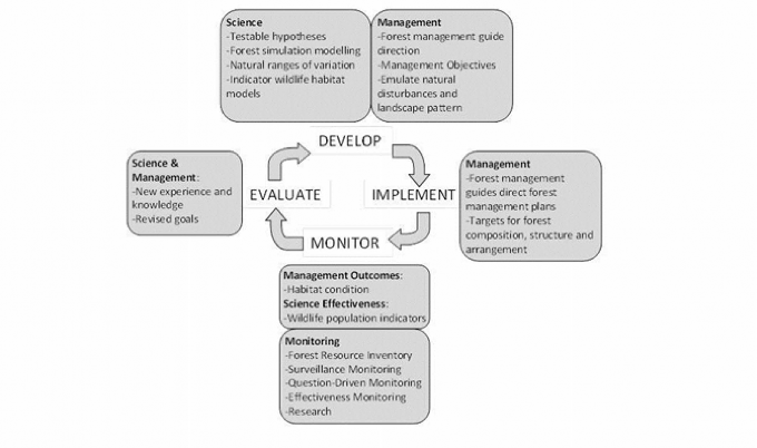
Figure 1. Conceptual framework of integrated wildlife population and habitat monitoring to support forest management.
The Forest EA directed that the species monitored include those which benefit from forests managed to maintain early successional stages, late successional stages, snags, dead and downed woody material, riparian areas, mature/over-mature stands, and large areas in a similar successional stage. Table 1 describes the primary forest conditions, forest management guides, and example species that form the basis for this monitoring program. Previous forest management guides directed management to provide habitat for featured wildlife species, which included species such as moose, marten, pileated woodpecker, and white-tailed deer (OMNR 1988; Naylor et al. 1996; Watt et al. 1996; Voigt et al.1997). The current forest management guides identify evaluative indicator species that represent the range of forest conditions managed for wildlife (OMNR 2010a; OMNR 2010b; OMNR 2012; OMNR 2014). Many more species will be monitored than are listed in Table 1 and the WPMP's internal surveys and external partnership surveys are expected to provide monitoring data for additional species of mammals, birds, and terrestrial reptiles and amphibians. The MSIM design is flexible to accommodate additional species protocols tailored to specific monitoring objectives and as permitted by available funding. The full list of species that can be detected with the existing protocols, and with sufficient reliability to assess status and trends, will be determined and reported following the initial implementation of the MSIM protocols across all monitoring areas.
The species listed in Table 2 have been identified as evaluative indicator species due to the availability of clearly defined habitat associations and quantitative targets to support forest management planning and assumed responsiveness to landscape-level variation in habitat conditions. Additional rationale for selection of these species is provided in OMNR (2012) and includes representation of the range of habitat currently being modelled in forest management planning, species at risk, socially desirable species, and the ability to monitor species.
In addition to the core objective to track long-term status and trends in wildlife species, the collection of long term population and habitat information will permit assessment of the usefulness and representativeness of selected indicator species, refinement of habitat associations, and ultimately, evaluation of the maintenance of biodiversity in Ontario’s managed forests.
Table 1. Forest EA habitat condition, guideline documents, and example species to be monitored under the MSIM program.
| Forest Condition / Forest Management Guides | Species or Groups |
|---|---|
| Early successional stage forest Current guides: Former guides: | Mammals: moose, black bear Birds: |
| Late successional stage forest Current guides: Former guides: | Mammals: marten, fisher, northern flying squirrel Birds: |
| Snags, dead and downed woody material; Riparian areas; Mature/overmature stands; Large areas in a similar successional stage Current guides: Former guides: | Mammals: woodland caribou, marten, southern red-backed vole, deer mouse Amphibians: Birds: |
Table 2. Species and species groups identified as evaluative indicators in forest management planning. The boreal songbirds were identified in Rempel (2007a). Species marked with an asterisk are expected to be detected using planned MSIM protocols.
| Great Lakes Saint Lawrence Forest Region | Boreal Forest Region |
|---|---|
| Moose (Alces alces)* | Lynx* |
| White-tailed deer (Odocoileus virginianus)* | Northern flying squirrel |
| Black bear (Ursus americanus)* | Snowshoe hare* |
| Lynx (Lynx canadensis)* | American marten* |
| Snowshoe hare (Lepus americanus)* | Moose* |
| Marten (Martes americana)* | Woodland caribou (Rangifer tarandus)* |
| Fisher (Martes pennanti)* | Alder flycatcher* |
| Northern flying squirrel (Glaucomys sabrinus) | Black-and-white warbler* |
| Southern flying squirrel (Glaucomys volans) | Bay-breasted warbler* |
| Spruce grouse (Falcipennis canadensis) | Blackburnian warbler* |
| Beaver (Castor canadensis) | Brown creeper* |
| Wood duck (Aix sponsa) | Common yellowthroat* |
| Red-shouldered hawk (Buteo lineatus) | Chestnut-sided warbler* |
| Northern goshawk (Accipter gentiles) | Kirtland’s warbler* |
| Barred owl (Strix varia) | Least flycatcher* |
| Ruffed grouse (Bonasa umbellus) | Ovenbird* |
| Pileated woodpecker (Dryocopus pileatus)* | Red-breasted nuthatch* |
| Pine warbler (Dendroica pinus)* | Red-eyed vireo* |
| Winter wren* | |
| White-throated sparrow* |
WPMP approaches to monitoring
The WPMP addresses its mandate using a combination of field-based surveys internal to the program, integration of existing monitoring and forest management information products from other MNRF programs, and partnerships with external organizations. Details of each component and a general summary of the organizational structure of the WPMP are described in subsequent sections. The monitoring approach generally includes a combination of broad and fine scale monitoring for making assessments of habitat and population trends and to support the evaluation of forest management planning and guide effectiveness. Existing coarse-scale surveillance monitoring activities may need to be augmented to achieve adequate spatial and/or temporal coverage and resolution to address its primary questions. The feasibility of augmenting surveys will be considered as needs arise and based on availability of additional resources.
Key components to our approach are the evaluation, assessment, reporting, and transfer of results in support of program goals (see Section 4.0 and 5.0). Population and habitat trends for species, guilds, communities, and functional assemblages will be evaluated against outcomes predicted from forest management planning tools and management guidelines. Evaluations of populations and habitats at broad scales and for long time periods will require a significant investment in data and information management processes and technologies in order to organize and maintain data from multiple sources.
MNRF's Provincial Wildlife Population Monitoring Program includes several integrated components:
- Monitoring of a wide variety of wildlife species
- Periodic assessment of species' status and trends
- Monitoring of habitat to inform assessment of the outcomes of forest management that may affect wildlife populations.
- Investigation and development of techniques and, as appropriate, protocols for detecting and collecting monitoring data for priority species
- Collaboration with technical experts within MNRF, or with external partners, on a variety wildlife population-related projects that can enhance the value of the program.
It is anticipated that the results of WPMP monitoring assessments will indicate additional monitoring and research needs to better address monitoring questions as well as to better inform Effectiveness Monitoring. Additional data collection may also be required for specific species, habitats, timeframes, or treatments of interest that are not adequately covered by the existing activities of the WPMP that can be achieved with currently available resources. For example, fine scale or more intensive monitoring may be needed to support testing the effectiveness of the Forest Management Guides and to inform assessment of population change for specific species where existing course scale monitoring is inadequate. If additional survey protocols or sampling effort are deemed necessary, planning will occur in co-operation with the relevant program areas, including the effectiveness monitoring program of the MNRF's Centre for Northern Forest Ecosystem Research.
7.1 Multiple species inventory and monitoring
The WPMP began implementing field-based Multiple Species Inventory and Monitoring (MSIM) protocols in 2013. These protocols acquire population information for terrestrial vertebrate species and fill a substantial prior gap in both geographic and taxonomic coverage. The MSIM protocols are a modification of an approach first developed by the U.S. Fish and Wildlife Service to monitor wildlife species on federal forest lands in the United States (Manley et al. 2004, 2006). The purpose of MSIM is to provide population data (presence and/or relative abundance) and associated habitat condition for a large number of species over a broad scale in both time and space using a consistent set of protocols. Benefits of this approach for species with adequate detection rates may include estimates of status and trends in species presence or relative abundance, detection of spatially explicit changes in distribution, changes in wildlife community composition, and contribution to habitat modelling that can improve existing forest management planning tools. The MSIM approach, with its multiple protocols, is designed to detect as many species as possible, maximizing the return on monitoring dollars. The core survey protocols currently include camera traps to record presence of medium to large mammals, audio recorders for forest birds and calling amphibians, salamander coverboards, and small mammal live trapping. Additional protocols may be added where resources permit and based on priority information needs.
The permanent monitoring sites are a random sample from a systematic 20 km x 20 km grid overlapping the portion of Ontario’s Area of Undertaking (AOU) for forestry on Crown Lands. A grid based (systematic) approach was deemed a more suitable long-term approach than stratification by habitat type. The grid provides consistency in site location, multi-scale analysis opportunities, and the ability to post-stratify by any number of factors. The systematic location of the grid across the province overcomes biases associated with road-side sampling and, potentially, allows the extension of monitoring using the same approach and protocols into non-AOU parts of the province. For operational purposes, the current survey area is divided into three monitoring zones with field activities conducted in one monitoring zone per year, with each site resurveyed every three years.
The field component of Ontario’s MSIM started in the summer of 2013. During the initial 3 years of implementation, the WPMP plan to develop standard protocols and platforms for data management, statistical analysis and reporting in cooperation with staff in the Natural Resources Information Section. The first cycle of survey data collection will be completed in 2015 and used to provide initial summaries of population status and to evaluate the cost-effectiveness and statistical effectiveness of the proposed design to address the monitoring objectives, and to determine which species can be effectively monitored. This work will take place during the span of this plan. Availability of resources will determine the magnitude of change that can be detected and the number of required to detect those changes.The WPMP will evaluate opportunities to re-align sampling effort to permit annual sampling at sites distributed across the provincial study area. Annual sampling is expected to increase statistical power to detect long-term temporal trends, which is an important aspect of the WPMP mandate.
There are many benefits to adopting an MSIM approach, not least of which are existing protocols for data collection and computer programs for data analysis (Manley et al. 2006). The MSIM approach is scalable in terms of both species groups that can be monitored and number of plots where monitoring takes place. Nevertheless, there are challenges to implementing MSIM in Ontario. Because of the nature of wildlife activity patterns, not all species can be detected with a single visit to each grid plot. Thus, multiple visits to deploy multiple protocols will be needed to track trends for a maximal number of species, placing limits on the overall sampling effort and protocols that can be conducted using existing resources. Logistical challenges also exist in accessing many of the sites on the systematic grid.
An MSIM design and field manual is under preparation and will describe in greater detail the purpose of MSIM, specific monitoring objectives, survey design, technical details for conducting standardized survey protocols, and direction for analysis and reporting on population data.
7.2 Linkages with other MNRF monitoring programs and initiatives
The WPMP has important linkages to other MNRF programs involved in provincial inventory, monitoring, and research. The wildlife surveys described below are programs where the survey designs are tailored to other monitoring objectives (e.g. to inform hunter harvest) but where the information generated can be effectively used as a component of Surveillance Monitoring for the WPMP. Generally, these surveys cover a large area of the province and overlap most or all of the area of forest management. Effective integration of monitoring information from these surveys requires cooperation across multiple Branches and Divisions of the MNRF that share responsibility for those programs, including field data collection, information management and data access. The WPMP will also need to be responsive and engaged in changing corporate priorities that may result in changes to the design and implementation of monitoring activities. Any such changes will be documented in future program plan updates.
7.2.1 Provincial inventory and monitoring
The MNRF implements a number of provincial trend inventories in support of wildlife program initiatives. The inventories are not the responsibility of the WPMP, but are related to and provide information to the program. Examples include population surveys and / or hunter surveys for moose, black bear, and white-tailed deer.
7.2.1.1 Moose population surveys
Aerial surveys for moose have been conducted across moose range in Ontario using a standardized design since 1975. Surveys are conducted using either a plot-based stratified random sample design or systematic transects. Inventories are conducted annually with the current aim of sampling each of the Wildlife Management Units (WMUs) in the main core of moose range at least every third year. This information is used for tracking moose populations and age-sex structure, preparing annual moose harvest plans, assessing habitat suitability and evaluating management strategies. The WPMP makes use of survey information (e.g. population densities) by compiling the data across WMUs that overlap the area of forest management. Analysis of long term trends at regional and provincial scales enables assessments in relation to changes in forest habitat conditions.
7.2.1.2 Hunter surveys for large mammals
The Natural Resources Information Section of MNRF co-ordinates hunter surveys for black bears, moose, and white-tailed deer and conducts data compilation, analysis, and reporting. The surveys provide information on hunter effort, harvest rate and hunter observations of wildlife, providing insight into the condition of populations of these species to support sustainable harvest allocations. This information has potential to be used to support trend assessments for the WPMP; however, it is anticipated that the MSIM camera survey will generate more consistent and direct population indices for these species. The hunter survey data may be used as corollary information to MSIM to support assessment and reporting activities.
7.2.2 Other wildlife monitoring
Some wildlife species that are under the mandate of the WPMP are addressed by existing monitoring effort or require specialized surveys (e.g. species at risk) that may be beyond the scope of the WPMP under existing resources and priorities (e.g. woodland caribou and wolverine). MNRF released a Woodland Caribou Conservation Plan (OMNR 2009) that identified monitoring requirements to meet recovery objectives, support research on the effects of anthropogenic disturbance on caribou persistence, and to inform policy development and management decision-making. Ontario conducted population range monitoring for caribou between 2010 and 2013 at the local population range level to support a range management approach to caribou recovery. Wolverine (as well as woodland caribou, moose and wolves) have been surveyed following the methodology of Magoun et al. (2007) as part of OMNR's Far North Planning Initiative. In addition to aerial surveys, wolverine monitoring efforts focused on the evaluation and implementation of remote camera and hair snagging surveys in conjunction with Red Lake District staff and research staff. A manual of wolverine monitoring techniques and protocols has recently been published (Koen et al. 2008).
The long term commitment to collect population monitoring information for caribou and wolverine is currently unknown. The WPMP will make use of available monitoring information that overlaps the area of forest management. Effective use of such information will require evaluation to determine whether it can be effectively integrated with existing assessment and reporting activities.
7.2.3 Forest management planning
Addressing monitoring goals that link assessment of trends in wildlife populations and habitat will require cooperation with the Crown Forests and Land Policy Branch of MNRF. There will be value to assess wildlife trends in relation to habitat supply targets established by existing forest management planning tools (e.g. simulated ranges of natural variation in habitat indices). These assessments will require collation and summary of information across data sets (Forest Resource Inventory [FRI], field-collected forest vegetation data, wildlife data) that may be internal and external to the WPMP. The assessment products will be directly relevant to updates to the Landscapes Guide planning tools (wildlife habitat models in the science packages, evaluation standards) as coordinated by Crown Forests and Land Policy Branch.
Access to FRI data will be integral to the WPMP goal to track changes in wildlife populations and habitat at broad scales. FRI products will be provided through the Natural Resources Information Section of Science and Research Branch and Crown Forests and Land Policy Branch. Details of the use of FRI for habitat monitoring are provided in Section 7.4.
7.3 Partnership with external organizations
MNRF values the opportunity to work with partners and continues to develop and expand these relationships. The Provincial Wildlife Population Monitoring Program has developed a strong partnership with Bird Studies Canada over the past two decades by supporting and co-operating in the ongoing implementation of several monitoring surveys. The main products and partnership monitoring activities have included the Ontario Breeding Bird Atlas, Nocturnal Owl Survey, and Migration Monitoring surveys. This partnership has benefited both parties by contributing to the present state of knowledge on the status and trends of many bird species, and by maximizing volunteer participation in bird surveys. The program has also had several short- and long-term partnerships with universities, including a long-term small mammal study in Algonquin Provincial Park with the University of Guelph. Opportunities to expand existing partnerships and initiate new partnerships within the context of this plan will be evaluated as they arise.
The partnership with Bird Studies Canada relies on volunteers to collect survey data. While this approach has proven highly useful, the distribution of the human population in Ontario makes it difficult to engage citizens in northern areas of Ontario. For example, during the production of the last Breeding Bird Atlas, arrangements had to be made to transport volunteer experts from southern Ontario into remote locations and expert level field crews had to be hired to ensure representative coverage across the north. Similarly the Breeding Bird Survey relies upon a limited number of volunteers in Northern Ontario -- resulting in poor ability of this survey to detect trends for most bird species north of North Bay (Ontario Partners in Flight 2006). Attempts to expand Breeding Bird Survey coverage by offering volunteers reimbursement for expenses has recently shown some promise and is currently being evaluated in partnership with Bird Studies Canada. The difficulty of engaging citizens in wildlife surveys is much greater for mammal, reptile, and amphibian surveys. Badzinski et al. (2008) assessed data from four volunteer-based frog and toad monitoring programs, and found that there was very poor coverage in both central Ontario and northern Ontario.
The partnership surveys with Bird Studies Canada provide Surveillance Monitoring information at generally broad scales and were not designed to evaluate the effects of forest management. Despite known limitations, the existing partnership surveys will be useful for calibration and validation of the MSIM sampling program and also fill a taxonomic gap for owls that are not covered by MSIM. Notably, it will take many years for the MSIM program with its current survey effort to acquire enough information to inform long term trends. The annual information collected by Bird Studies Canada partnership surveys will provide essential information to aid in meeting the objectives of the WPMP. The Nocturnal Owl Survey and Breeding Bird Survey are especially valuable as they are spatially explicit, and collect annual data at permanent monitoring sites that overlap much of the area of forest management in Ontario.
7.4 Habitat monitoring
The ability to compare wildlife population monitoring results with changes in habitat condition at broad scales provides the WPMP's key support to inform the effectiveness of forest management in sustaining wildlife populations at regional and provincial scales. Habitat monitoring will be conducted using the Forest Resources Inventory (FRI) program (external to the WPMP) and the WPMP's own MSIM protocols that include vegetation habitat sampling. Vegetation structure, composition, and distribution that will be monitored for wildlife species may include landscape elements (e.g., patch size, patch density, edge density, nearest neighbour distance, patch diversity, and contagion), stand elements (e.g., tree species composition, canopy age, height, and stocking; vertical and horizontal structure) and site elements (e.g., herb and shrub layer, vegetation composition and structure, soil type, abundance of woody debris, and abundance of cavity trees).
The FRI provides repeat measures every ten years on forest composition, structure, and distribution across the entire landscape as well as through repeated measures of conditions on a standardized grid network of permanent ground plots. Landscape dynamics simulation models use FRI as the primary land cover inventory (e.g., Rempel et al. 2007b). The prescriptive targets set in the Landscape Guide will provide a relevant set of benchmarks/standards for evaluating trends in wildlife habitat supply. Broad-scale habitat information will provide important context for the interpretation of wildlife population trends as determined from both surveillance and effectiveness monitoring.
Methods will be evaluated for making inferences among the FRI datasets for broad-scale habitat assessment. As the FRI program functions independently of the WPMP, close co-ordination and integration of these data sources will be critical to the success of habitat monitoring. WPMP staff will co-ordinate mutual activities to ensure the value of collected data is maintained for different programs and to ensure timely and direct access to data as needed for the completion of monitoring reports.
Although the interpreted FRI and existing permanent sample plot data are expected to be adequate for broad scale surveillance monitoring of habitat trends for indicator wildlife species in the forest management guides, EA Condition 30 requires monitoring of wildlife species assumed to benefit from guide direction, but not explicitly described using guide indicators. For many of these species, wildlife-habitat relationships are poorly understood and attributes available in the FRI may not capture habitat features that are important to wildlife population dynamics and that are affected by forest management (e.g. shrub and ground layer attributes). The MSIM protocols will provide detailed, site- specific habitat information that is temporally paired with the collection of wildlife population data. Wildlife species respond to habitat quality, quantity, and configuration at multiple spatial and temporal scales. The specific elements and scale of measurement employed for wildlife habitat monitoring will reflect the scales at which those habitat components are deemed most influential to animal behaviour, population response, or population range occupancy. Priority will be given to measures that are commonly used, easily employed, have standardized data collection methods, and are least expensive to measure.
Considerable additional effort will need to be put towards scoping the WPMP's approach to analysis, assessment, and reporting on habitat. At the surveillance scale, WPMP staff will need to work closely with FRI program staff to ensure that FRI measurements are accessible in a manner that allows them to be used for habitat analyses. Fine scale habitat variables not included in FRI datasets will be collected through the MSIM design, and assessment of the feasibility of habitat assessment at fine scales will be incorporated into the evaluation and update of MSIM protocols if necessary.
7.5 Addressing gaps in monitoring
Where uncertainty exists in a species' status or trend using existing WPMP activities, more rigorous, fine-scale data collection may be necessary to verify population trend. This would generally require greater statistical power and confidence levels than can be obtained from existing surveillance monitoring, including MSIM. Such targeted monitoring may be required to answer specific questions about a population, habitat feature, or species group of interest (akin to Question-Driven Monitoring, Section 3). Specialized surveys may be used to reduce uncertainty and improve information for a particular species, and may involve more intensive sampling effort, smaller study areas, more limited time periods, specific habitat types, special techniques, or a combination of the above. Such targeted monitoring can be focused on ecosystem components selected because of risk, concern, or interest; it can be focused on components that are likely to change; it can be tied directly to management activities; it is relatively efficient and cost effective; it has a high probability of detecting the targeted changes; and, it can be used to compare existing conditions to both past conditions and desired future conditions.
7.5.1 Amphibians and reptiles
There has been little in the way of long-term, broad-scale monitoring undertaken for amphibians and reptiles in Ontario, both because there has traditionally been less interest in these taxa and because many of them are difficult to detect. The MSIM protocols currently include a survey directed at red-backed salamanders, which also provides incidental observations of other salamander species. Digital audio records are used to collect information on calling amphibians. The range of species for which adequate data exists to reliably track population trends will be evaluated following the completion of the first round of MSIM surveys in 2015. Other than MSIM, only one surveillance monitoring program, the Marsh Monitoring Program (co-ordinated by Bird Studies Canada and aimed at both birds and amphibians), is currently active in the area of forest management. The Marsh Monitoring Program provides statistically reliable surveillance monitoring trends for seven species in primarily coastal marshes of the Great Lakes basin (Crewe et al. 2006). The Marsh Monitoring Program may have potential for extending the design for amphibian monitoring to a larger geographic area, beyond the Great Lakes nearshore areas, and to include a wider variety of wetland types (in addition to marshes). The WPMP may consider the feasibility of expanding this survey as a component of existing surveillance monitoring.
Amphibian Road Call Counts and Backyard Frog Surveys, two programs that have been in place since 1992 in southern Ontario, have recently been evaluated by Environment Canada – Environmental Monitoring and Assessment Network and BSC staff (Badzinski et al. 2008) to determine their utility and potential for expansion. This analysis revealed differences in the direction of species trends among the monitoring programs evaluated. This may be due to a number of different factors such as differences in species detectability between protocols used in the two programs and type of habitat being sampled. Badzinski et al. (2008) noted that the issue of species detectability needed to be addressed, particularly for the Amphibian Road Call Counts and also the Marsh Monitoring Program. Geographic coverage was also noted as an issue as none of the programs have intensive sampling in northern Ontario and only weak coverage in central Ontario.
Lakehead University recently completed a project evaluating monitoring techniques for reptiles and amphibians in the Lake Superior basin for the Lake Superior Bi-National Program (Hecnar and Casper 2009). This project is based on detection/non-detection data and calculation of percent area occupied statistics. Results from this effort will be examined to inform the MSIM evaluation and will be incorporated into WPMP monitoring efforts where appropriate. Ontario Nature is currently leading a renewed Ontario reptile and amphibian atlasing project in which the MNRF and the WPMP are partners. This effort should increase our baseline knowledge of species distributions in the province over the next few years.
7.5.2 Bats
Many species of Ontario bats are reliant on a variety of forest conditions relevant to the forest EA Condition 30. See Lacki et al. (2007) for a comprehensive description of forest bat ecology. Further, from a broader MNRF and biodiversity context several forest bats have experienced severe declines resulting from white-nose syndrome and are now listed as species at risk by Ontario and Canada.
The WPMP may consider a bat monitoring component within the MSIM framework. MSIM plot selection is partially consistent with that suggested by the North American Bat Monitoring Program (Loeb et al. 2015) and resultant data may well contribute to their objectives in addition to the objectives of this plan.
7.6 Organizational structure to support program delivery
The Provincial Wildlife Population Monitoring Program is coordinated and delivered through the Science and Research Branch. Program staff work together with the science community, advisors, and partners to develop and integrate program direction, work plans and budgets, sampling designs, and field protocols. Field operations are implemented on a regional basis. Data management, analysis, assessment, and reporting are typically centralized functions. The Terrestrial Assessment Unit of the Forest Research and Monitoring Section is currently responsible for overall provincial coordination of the program, including technical science support in program design, maintenance of the program plan, administration of external partnerships, Forest EA related reporting requirements, and integration of monitoring information with forest management planning tools and processes. Permanent regional staff of the WPMP, currently housed within the Biodiversity and Monitoring Section, are responsible for coordination and delivery of field activities in each of the three MNRF administrative regions. Data collection is conducted by seasonal employees working under the supervision of permanent WPMP staff. Where opportunities arise, logistical support is provided from various MNRF offices across the province where field work is conducted. Permanent staff of the WPMP across regional and provincial sections of Science and Research Branch share responsibilities for annual work planning and budgeting, analysis, interpretation and reporting of monitoring information.
Methods evaluation and development
The WPMP will continue to explore opportunities to enhance existing surveys where known deficiencies exist. For example, the WPMP is working with Bird Studies Canada to enhance the Breeding Bird Survey in northern portions of the survey area were sample sizes are inadequate to reliably track population trends for many species. As described previously, the WPMP will evaluate the adequacy of the MSIM design to address its objectives following the first round of field work in 2015. Proposed changes will be identified in subsequent technical publications and updates to the Program Plan.
An important existing gap is the need to develop standardized analytical procedures to support assessment and reporting. This is especially needed to support comparison of wildlife trends to habitat conditions and predictions within existing forest management planning processes. Staff in the WPMP will work with other specialists and research scientists to develop these tools.
During the period covered by this plan, staff of the WPMP will continue to contact species experts as appropriate and to perform regular scans of the scientific literature to determine whether new techniques appropriate to detecting Ontario wildlife species have been developed. Other agencies within Ontario and Canada are also concerned with monitoring wildlife populations and are working on the development of improved techniques, particularly for forest birds and amphibians. WPMP staff will continue to liaise with staff of these agencies. Tests of available equipment or techniques also will be conducted by WPMP staff, as appropriate.
Assessment of species status
The intent of the habitat direction in the forest management guides is to maintain forest communities within ranges of natural variation, with the assumption that associated wildlife communities will also be sustained. An important role for the WPMP is to identify when populations appear to be declining or increasing in directions inconsistent with desired management objectives for wildlife. An objective evaluation of risk is needed to assist in determining when changes in wildlife population indices or habitat features may require additional monitoring, management or conservation intervention (Figure 2). The WPMP staff will work with other specialists and scientists to develop methods to identify important magnitudes of changes in monitoring indicators. Although program staff can support work on species at risk, leading the extremely targeted research and monitoring required for rare species is beyond the scope of the WPMP.
In instances when there is high uncertainty in the available population and/or habitat supply data, additional investigation may be required. Species, guilds, habitat units, or structural features identified by this evaluation may undergo more rigorous investigation (targeted monitoring) to confirm their status and, if necessary, research studies may be recommended to elucidate the causal mechanism of population change.
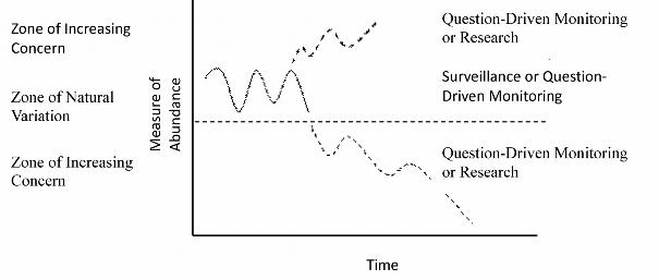
Figure 2. A conceptual representation of types of monitoring and associated risk assessment for the Wildlife Population Monitoring Program.
Program outputs
There are a variety of outputs from the WPMP including: sampling methodologies; field manuals and monitoring protocols; population data for selected species; and reports. These program outputs can be grouped into seven categories:
- Monitoring infrastructure
- Standardized sampling techniques
- Long-term trend data
- Database development and maintenance
- Expertise and knowledge transfer
- Reports
- Information management
10.1 Monitoring infrastructure
A monitoring infrastructure consisting of the permanent MSIM sample plot network will continue to be established, maintained, and augmented as required. Sample plots will be geo-referenced and have consistent baseline descriptions. The plot network will represent a valuable resource for present and future wildlife population monitoring and will serve programs other than the WPMP, including wildlife research and forest management guide testing. Infrastructure also includes the significant initial investment and regular replacement of the electronic recording devices necessary for undertaking the MSIM protocols.
10.2 Standardized sampling techniques
Sampling techniques that are evaluated and adapted as needed for successful application under the range of conditions found in Ontario will be documented. These sampling techniques will provide the basis for field manuals that guide the collection of high quality standard wildlife population data in Ontario and that meet the goals and objectives of the WPMP.
10.3 Long-term trend data
The WPMP collects population and population related data through data collection from permanent sample plot measurements, or through collaborative projects with its partners.
These measurements produce time-series data for the time period that the project has operated, with each new season of data collection adding to the time series. The time series can be analyzed for trends, the lengths of which are determined by a management question or the length of the period of interest. This period may also be influenced by the ecology of the particular species (e.g. population cycles) and variability in the data.
10.4 Database development and maintenance
The WPMP will continue to develop and maintain a number of databases for wildlife population and population related data. The data in the databases are collected to provincial standards, cleaned, validated, and are complete with meta-data based on a data management and maintenance schedule. These databases provide information for products produced by Natural Resources Information Section staff and many other science and research investigators.
10.5 Expertise and knowledge transfer
The program will provide expertise related to wildlife data collection and analysis. This expertise supports the WPMP and the MNRF as a whole in other resource management programs involved with wildlife-related management issues as well as other types of sampling and monitoring.
Knowledge related to the sampling and monitoring of wildlife populations will be transferred to practitioners, other resource professionals, collaborators, and partners through seminars, workshops, reports, and field training. Communication will be an ongoing process relying on a variety of techniques and products that reach the widest possible audience to ensure that data and information products are available to support resource management activities.
10.6 Reporting
It is essential that the work of the WPMP be communicated through a formal reporting process to effectively inform policy decisions and management direction. This process will consist of the production and dissemination of annual reports, five year reports, input into other reporting processes, technical reports on the results of individual activities, and long-term assessment reports.
The WPMP will produce an annual report that will describe the annual accomplishments of the program; provide interim interpretation of monitoring signals, if appropriate; and make recommendations for future work. These annual reports will form the basis of the WPMP's input to the annual report of the Science and Research Branch. It will also constitute the WPMP's report to Crown Forests and Land Policy Branch for the Provincial Forest Technical Committee.
The Program will produce technical reports as they are completed. These reports will document such things as processes, interim data analyses and assessments, assessment of sampling methods, feasibility studies, and recommendations. Reports will include objective evaluation of data and information for some species that may be declining or increasing. Technical reports could focus on individual species or functional groups. This information will provide the basis of input to other reporting requirements within MNRF.
The Provincial Wildlife Population Monitoring Program will produce a five-year report that covers the period 2015 to 2020. The report will be an assessment of all Program activities to form the basis of input into the State of the Forest Report (Crown Forests and Land Policy Branch), summarize what has been learned over the five-year period, and contain the next five-year implementation schedule.
The program will provide input as required into other five-year reporting requirements. These other requirements include the Five-Year Environmental Assessment Report, the next Canadian Council of Forest Ministers' Report and MNRF's input into the report on the State of Ontario’s Biodiversity.
10.7 Information management
Information management is an essential component of the program. The following methods and principles are intended as integral elements of information management activities within the program.
- Data entry and management applications will be developed concurrently with new or updated sample designs and field data collection protocols;
- Data entry and management applications will be developed in a form compatible with other Natural Resources Information Section applications;
- Data entry and management applications will be transparent in their function;
- Data entry and management application development will be:
- affordable by the program
- readily useable by program staff, and
- consistent with corporate policy
- Data entry and management applications will be updated and maintained to current software standards;
- Responsibility for data collection will include responsibility for supplying cleaned and validated data to the administrators of central databases;
Information management will require collaboration between WPMP and Natural Resources Information Section staff. Program data and information will be shared under formal agreement with a requirement of correct acknowledgement of the source and receipt of a copy of the end product. Co-authorship may also be a requirement for the data share under some circumstances. Information management will be accomplished in a fashion that reflects the vision, values, goals, and key actions outlined in the Ministry of Natural Resources Information Management Strategy (OMNR 2007).
Implementation schedule: 2015-2019
The Provincial Wildlife Population Monitoring Program will continue to implement wildlife surveys, evaluate and develop monitoring methods, and conduct analysis and reporting of monitoring information (Table 3).
In the initial years of this Program Plan implementation, the WPMP will need to invest in the development of data management, assessment and reporting tools to support delivery of MSIM. Following the MSIM 2015 field season, and dependent on resources, the WPMP will evaluate the need for methodological improvements in MSIM and develop standardized approaches to track indicator wildlife species and their habitat targets consistent with forest management planning processes. Such tools will be important to determine whether changes in population indices are consistent with predicted outcomes of forest management and will help to identify whether additional monitoring, research, management or conservation effort may be needed to verify or respond to observed trends.
Table 3. Implementation activities for the Provincial Wildlife Population Monitoring Program for the period 2015-2020.
| Activity | 2015 | 2016 | 2017 | 2018 | 2019 |
|---|---|---|---|---|---|
| Surveillance Monitoring | |||||
| Breeding Bird Survey enhancement | Yes | Yes2 | Tentative | Tentative | Tentative |
| Migration Monitoring | Yes | Yes | Yes | Yes | Yes |
| Nocturnal Owl Survey | Yes | Yes | Yes | Yes | Yes |
| Multiple Species Inventory and Monitoring (MSIM) | |||||
| Field implementation | Yes | Yes | Yes | Yes | Yes |
| MSIM Additional Protocol Development and Assessment | Yes | Yes | Yes | Yes | Yes |
| MSIM Database Development, Analysis, and Reporting Framework | Yes | Yes | Yes | ||
| Reporting | |||||
| Annual Report on Wildlife Assessment | Yes | Yes | Yes | Yes | Yes |
| Intermittent Technical Reports | As completed | ||||
| Wildlife Assessment Five-Year Report | Yes | ||||
| Input to other MNRF Five-Year Reports | As needed | ||||
| Reporting | |||||
| Annual Report on Wildlife Assessment | Yes | Yes | Yes | Yes | Yes |
| Intermittent Technical Reports | As completed | ||||
| Wildlife Assessment Five-Year Report | Yes | ||||
| Input to other MNRF Five-Year Reports | As needed | ||||
Literature cited
Badzinski, D. S., R.W. Archer, S.T.A. Timmermans, K.E. Harrison and K.E. Jones, revised by M. Doyle. 2008. Assessment of Trends in Frog and Toad Populations in Ontario using Citizen Science Monitoring Data. Bird Studies Canada. Prepared for The Ecological Monitoring and Assessment Network Coordinating Office, Environment Canada. 14 pp.
Blancher, P.J., R.D. Phoenix, D.S. Badzinski, M.D. Cadman, T.L. Crewe, C.M. Downes, D. Fillman, C.M. Francis, J. Hughes, D.J.T. Hussel, D. Lepage, J.D. McCracken, D.K. McNicol, B.A. Pond, R.K. Ross, R. Russell, L.A. Venier and R.C. Weeber. 2009. Population trend status of Ontario’s forest birds. Forestry Chronicle 85: 184-201.
Crewe, T.L., S.T.A. Timmermans and K.E. Jones. 2006. The Marsh Monitoring Program 1995- 2004: A decade of marsh monitoring in the Great Lakes region. Bird Studies Canada in cooperation with Environment Canada. 28 pp.
Hecnar, S.J. and G.S. Casper. 2009. Development of a Lake Superior Basin Amphibian and Reptile Monitoring Program. Final Report of E.P.A. Great Lakes Grants Program Project #2004-0005-202. 67 pp.
Holthausen, R., R.L Czaplewski, D. DeLorenzo, G. Hayward, W.B. Kessler, P. Manley, K.S. McKelvey, D.S. Powell, L.F. Ruggiero, M.K. Schwartz, B.V. Horne and C.D. Vojta. 2005. Strategies for monitoring terrestrial animals and habitats. General Technical Report RMRS-GTR-161. Department of Agriculture, Forest Service. Rocky Mountain Research Station, Fort Collins.
Koen, E.L., J.C. Ray, J. Bowman, F.N. Dawson, and A.J. Magoun. 2008. Surveying and monitoring wolverines in Ontario and other lowland, boreal forest habitats: Recommendations and protocols. Ontario Minstry of Natural Resources., Northwest Science and Information. Thunder Bay, Ont. NWSI Field Guide FG-06.
Lacki, M.J., J.P. Hayes, and A. Kurta (Eds.). 2007. Bats in forests. Johns Hopkins University Press, Baltimore, MD. 329 pp.
Lindenmayer, D.B. & Likens, G.E. 2009. Adaptive monitoring: a new paradigm for long-term research and monitoring. Trends in Ecology and Evolution. 24: 482-486.
Lindenmayer, D. B. and G.E. Likens. 2010. The science and application of ecological monitoring. Biological Conservation. 143: 1317–1328.
Loeb, C.L., T.J. Rodhouse, L.E. Ellison, C.L. Lausen, J.D. Reichard, K.M. Irvine, T.E. Ingersoll, J.T.H. Coleman, W.E. Thogmartin, J.R. Sauer, C.M. Francis, M.L. Bayless, T.R. Stanley, and D.H. Johnson. 2015. A plan for the North American bat monitoring program (NABat). US Forest Service Research & Development Southern Research Station General Technical Report SRS-208.
Magoun, A. J., J.C. R. Devin, S. Johnson, P.K Valkenburg, F.N. Dawson, and J. Bowman. 2007.
Modeling Wolverine Occurrence Using Aerial Surveys of Tracks in Snow. Journal of Wildlife. Management. 7: 2221-2229.
Manley, P.N., B. Van Horne, J.K. Roth, W.J. Zielinski, M.M. McKenzie, T.J. Weller, F.W. Weckerly, and C. Vojta. 2006. Multiple species inventory and monitoring technical guide. Gen. Tech. Rep. WO-73. U.S. Department of Agriculture, Forest Service, Washington, DC.
Manley, P.N., Zielinski, W.J., Schlesinger, M.D., and Mori, S.R. 2004. Evaluation of a multiple-species approach to monitoring species at the ecoregional scale. Ecological Applications. 14: 296-310.
Naylor, B.J., Baker, J.A., Hogg, D.M., McNicol, J.G. and Watt, W.R. 1996. Forest Management Guide for the Provision of Pileated Woodpecker Habitat. Queen’s Printer for Ontario.
OMNR. 1988. Timber Management Guidelines for the Provision of Moose Habitat. Queen’s Printer for Ontario.
OMNR. 2007. Ministry of Natural Resources Information Management Strategy.
OMNR. 2009. Ontario’s woodland caribou conservation plan. Queen’s Printer for Ontario, Toronto.
OMNR. 2010a. Provincial Wildlife Population monitoring Program Plan. Version 2.0, June 2010. Ministry of Natural Resources. Science and Research Branch. 53 pp.
OMNR. 2010b. Forest Management Guide for Great Lakes - St. Lawrence Landscapes. Queen’s Printer for Ontario, Toronto.
OMNR. 2012. Science and Information in Support of Ontario’s Forest Management Guides for Landscapes: Science Package Series A. Queen’s Printer for Ontario.
OMNR. 2014. Forest Management Guide for Boreal Landscapes. Queen’s Printer for Ontario, Toronto.
Ontario Partners in Flight. 2006. Ontario Landbird Conservation Plan: Boreal Softwood Shield (North American Bird Conservation Region 8), Priorities, Objectives and Recommended Actions. Version 1.0. Environment Canada and Ontario Ministry of Natural Resources.
O'Malley, S., C. Wilkinson, and G. Miller. 2013. "Nothing to report": the failure of Ontario’s provincial wildlife population monitoring program for commercial timber harvesting. Journal of Environmental Law and Practice.24: 29-47.
Rempel, R. S. 2007a. Selecting focal songbird species for biodiversity conservation assessment: response to forest cover amount and configuration. Avian Conservation and Ecology 2: 6.
Rempel, R. S., J. Baker, P. C. Elkie, M. J. Gluck, J. Jackson, R. S. Kushneriuk, T. Moore, and A.H. Perera. 2007b. Forest policy scenario analysis: sensitivity of songbird community to changes in forest cover amount and configuration. Avian Conservation and Ecology 2: 5.
Rempel, R. S., J. Baker, G. Brown, J. Churcher, M. Gluck, and B. Naylor. 2011. Guide Effectiveness Monitoring: Strategic Direction. Information Paper CNFER IP-006. Ontario Ministry of Natural Resources, Centre for Northern Forest Ecosystem Research, Thunder Bay, Ontario, Canada. 18 pp.
Voigt, D.R., Broadfoot, J.D. and Baker, J.A. 1997. Timber Management Guidelines for the Provision of White-Tailed Deer Habitat. Queen’s Printer for Ontario.
1Schedule A, Term and Condition 81 of the Environmental Assessment Board approval (April 5, 1994) for the "Class Environmental Assessment by the Ministry of Natural Resources for Timber Management on Crown Lands in Ontario"; Term and Condition 30 of the Declaration Order MNR-71 granted June 2003 regarding MNR's "Class Environmental Assessment Approval for Forest Management on Crown Lands in Ontario"
2Decisions regarding continued support for the Breeding Bird Survey enhancement will be conducted in collaboration with Bird Studies Canada and based on an evaluation of cost-effectiveness.