1.0 Introduction
The Guide for Crown Land Use Planning (the Guide) provides guidance to the public, ministry and others about Crown land use planning. It provides consolidated direction for Crown land use planning which supports transparency and accountability in planning and establishes the primary policies and guidelines for Crown land use planning, as referenced under Section 12 of the PLA.
The Guide consists of two main parts. Part I focuses on Crown land use planning processes, and outlines requirements and suggested approaches for planning carried out on Ontario’s Crown lands administered under the PLA, as well as the context for Crown land use planning. Part II of the Guide presents or summarizes the provincial level policies for Crown land use designations.
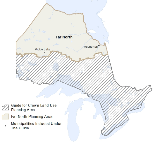
The Guide applies to land use planning for Crown lands that cover about 45% of Ontario including the beds of the Ontario portion of the Great Lakes. It applies to land use planning south of the Far North boundary and to land use planning on Crown land within the two municipalities located north of the Far North boundary (Pickle Lake and Moosonee), but does not apply to community based land use planning under the Far North Act.
In the Guide, the term “Crown land” is used to refer to all lands, including lands under water, administered under authority of the PLA. This term is used rather than “public lands” to avoid confusion with lands that are managed by the federal government and other public agencies, such as conservation authorities.
The Guide does not deal with the involvement of MNRF in land use planning carried out by other government agencies.
Standard:
The Guide must be applied in all Crown land use planning carried out under the authority of the PLA south of the Far North boundary, and to land use planning on Crown land within the two municipalities that are located north of the Far North boundary (Pickle Lake and Moosonee) (Figure 1 – MNRF’s Crown land use planning areas).
The Guide outlines a broad planning framework, with some key mandatory requirements referred to as “standards”. There are other requirements when working with Indigenous communities that may apply to some Crown land use planning projects, if the duty to consult is engaged on specific proposals.
Standard:
Within the portion of Ontario where the Guide applies, the direction outlined as a “standard” is mandatory.
Crown land use planning processes can range from a land use amendment that makes minor changes to the policies for a small parcel of Crown land, to comprehensive planning for large areas. Specific planning processes need to be tailored to fit the scope and nature of the issues that are being dealt with, the geographic scale of the planning, and the nature of public interest. As a result of this range in planning situations, most of the Guide provides advice or suggested best practices.
Standard:
All Crown land use planning within the area where the Guide applies must follow the direction outlined in the Guide.
The Guide is supported by various land use planning procedural documents which provide advice to MNRF staff involved in planning projects.