Dog River Conservation Reserve Management Statement
This document provides policy direction for the protection, development and management of the Dog River Conservation Reserve and its resources.
May 2002
W. Pamela Whyte
Resource Manager – Information Management
Thunder Bay
Approval statement
I am pleased to approve this Statement of Conservation Interest for the Dog River Conservation Reserve.
This Statement of Conservation Interest provides guidance for the management of the Conservation Reserve and the basis for the ongoing monitoring activities. More detailed direction is not anticipated at this time. Should significant facility development be considered or complex issues arise requiring additional studies, more defined management direction, or special protection measures, a more detailed Conservation Reserve Management Plan will be prepared with full public consultation.
The public was widely consulted during the designation and regulation of the site and further consultation is not required at this lime.
The Conservation Reserve will be managed under the jurisdiction of the Shebandowan and Spruce River Area Teams, Thunder Bay District, Ministry of Natural Resources.
Signed by:
W.D. Baker
District Manager
Thunder Bay District
Date: October 7, 2002
Charlie Lauer
Regional Director
Northwest Region
1.0 Background information
The purpose of this document is to identify the natural heritage values of Dog River Conservation Reserve, the activities which occur there and through a set of management guidelines, lay out the activities which will be permitted and not permitted and the direction of management for the area. From this, the management direction can be determined.
Background information
| Name | Dog River Conservation Reserve |
|---|---|
| Site Region / Site District | 3W-2 |
| OMNR Administrative Region/District/Area | Northwest / Thunder Bay / Shebandowan, and Spruce River Areas |
| Total Area (ha) | 2,658 hectares |
| Regulation Date | 2001 |
| First Nations | Fort William First Nation |
| OBM | 20163205410, 20163005420, 20163105410 |
| Lat./Long. | 48’55 °N 89’37 °E |
| Basemap | 32541, 30542, 31541 |
| Forest Resource Inventory | Found partly within the Sustainable Forest License of the Spruce River and the Dog River- Matawin Forests |
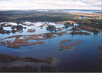
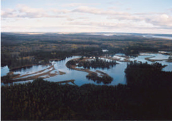
| General Location Description | Dog River Conservation Reserve is located at the Northwest end of Dog Lake. The reserve stretches from where Block Creek flows into the Dog River, extending down the Dog River shoreline, to its outlet into the Northwest Bay of Dog Lake. It is approximately 55 kilometers northwest of Thunder Bay. |
| Access | The conservation reserve can be accessed by boat at access points found on Dog Lake (Silver Falls Provincial Park, Dog Lake Resort, and North side of East Bay). The site can also be accessed by foot and ATV from the road network established in the Abitibi Freehold Block (#3) found to the west of the site and that established to the east of the site, also by Abitibi. |
Overview map: Dog River Conservation Reserve.

Enlarge overview map: Dog River Conservation Reserve.
1.2 Representation targets
This section provides a summary of the earth and life science system and values and cultural resources represented; and recreational opportunities available or possible.
Life Science Representation: The site is provides a provincially significant representation of a low gradient, strongly meandering river with numerous well developed fluvial features such as meander loops, oxbow lakes, meander scars and point bars.
Extensive and complex wetland communities provide provincially significant moose habitat.
Significant Walleye spawning habitat along the majority of the river length.
Earth Science Representation : Provincially significant examples of post-glacial fluvial lacustrine deltaic deposits associated with spillways to glacial Lake Kewenaw (current day Lake Superior) and recent fluvial processes.
Cultural Resource Representation : The Dog River is of historical importance as it was a canoe route to the northwest used by fur traders. Numerous archeological sites, and cultural remains and artifacts related to voyageurs are found there.
Recreational Opportunities : Hunting, Fishing, Nature appreciation.
1.2 Survey information
This section provides an overview of the inventories completed their level of detail and any further inventories that are needed.
| Survey Level | Completed | Future Requirements |
|---|---|---|
| Life Science | Fall 2000 – Geowest Environmental Consultants Ltd. | No further Requirements |
| Earth Science | Fall 2000 – Geowest Environmental Consultants Ltd. | Detailed Earth Science Inventory to preserve fluvial landforms and assess fluctuating water levels on the Fluvial landforms. |
| Cultural | Confirmed with Ministry of Culture, Recreation, and Citizenship (2001). | Aboriginal Consultation |
| Recreational | September 2000. Recreational Inventory Assessment completed | Ongoing monitoring of use and impact to values being protected. |
2.0 Values to be protected
This section provides a description of the key natural heritage values on the site, and their condition relative to past resource use and management activities and their sensitivity to future land use and management activities.
The intent of this Statement of Conservation Interest is to protect values by establishing management guidelines for existing and potential uses in this area given the level of past disturbance and the nature of the existing features.
2.1 Forest values
The forest consists of a variety of mixed cover types contributing to a diverse assemblage of wildlife habitats. Forest stands tend to be fairly mature throughout the site, with a few younger age classes represented.
The Eastern side of the conservation reserve (Spruce River Forest Portion) has been previously harvested (1980’s) but a 200 m buffer protected the river. The Dog River Matawin Forest portion of the site has also been previously harvested (early 1980’s) but the river was protected with a 200 m buffer. The adjacent forest communities are highly diverse, including jack pine stands, and mixed-wood stands with components of pine, spruce, aspen and birch, and deciduous-dominated stands of aspen and birch.
2.2 Wetland values
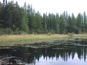
A highly diverse assemblage of wetland communities has developed in the complex fluvial environment of the Dog River floodplain. These vary from open water marsh communities to conifer and thicket swamps. Plant species are highly variable, depending on the water flow regime, water depth and substrate type.
2.3 Wildlife
Records of the Thunder Bay District show that the area has attraction due to the wildlife found there.
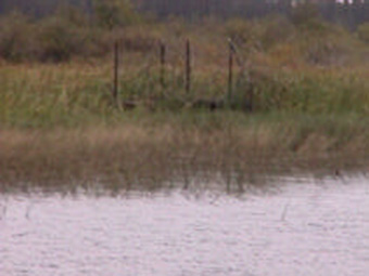
Dog River is a known aquatic feeding area for moose and deer. Three land use permits (hunt camps/rec camps) are found within the conservation reserve. The area is also home to ducks, geese and other migratory birds. The area is used during waterfowl-hunting season and a hunting blind is a permanent fixture on the landscape. Additionally, the area is used during the bear hunt.
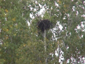
In addition to those species that are usually hunted, other species are also found in the area. Beaver lodges and an Eagles nest are found along the shoreline of the river. Fur trappers have recorded harvesting beaver, otter, fisher, marten, and muskrat from this area.
3.0 Management guidelines
3.1 Land tenure and candidate acquisition
Dog River conservation reserve consists entirely of Crown Land. Land owned by Abitibi Forest Products Ltd. forms the majority of the western boundary. The remainder of the boundary is generally a 500-metre buffer from Dog River.
- No new land use permits or crown leases will be issued for this site.
- current land use permits will continue.
- should any land use permit within the conservations reserve boundry lapse, the permit will be deemed forfeited and structures found within removed by the leand use permit holder and then the Ministry of Natural Resources.
3.2 Existing and proposed development
Forest access roads do cross into the boundary of the conservation reserve. They are now abandoned by harvest operators but used by the holder of a land use permit on the shoreline of the Dog River.
- these roads will not be maintained or upgraded by MNR.
- new improvements to this road by an land use permit holder on the Dog River must consult with the Shebandewan Team at the Ministry of Natural resources, Thunder Bay district.
- new access roads will not be permitted.
- non-motorized trail developmetn may be considered where it might enhance nature appreciation but only if it will not intererfere with natural processes
- the marshes found within the Dog River Conservation reserve, while not yet evaluated, are considered to be provincially significant and should be managed to protect wetland values. The area also has documented (with the Ministry of Culture, Tourism and Recreation) sensitive cultural and archeological values.
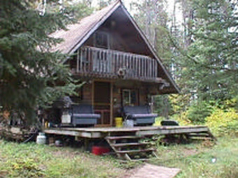
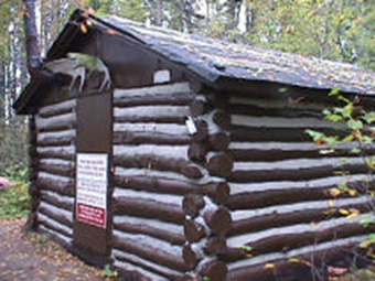
Currently there are three hunt camps and two trapper cabins constructed and maintained within the boundary of the Dog River Conservation Reserve.
- no new trapper cabins will be allowed in the conservation reserve.
- new private hunt/recreation camps are not permitted.
- site rehabilitation of currently identified land use permits and trap cabins will be allowed.
3.3 Recreational activities
The wetland vegetation and its associated species are the highest risk to recreational use through both over-fishing and hunting or shoreline damage.
- recreational activities that have been previously enjoyed in this area can continue provided they are not damaging wetland vegetation or its associated species.
- canoeing and general nature appreciation are non-restricted permitted uses.
- hunting and fishing is subject to Ontario Hunting and Fishing Regulations.
- motorized vehicle will be permitted to continue where they do no adversely affect the values being protected.
- use off trails is not permitted except for the retrieval of game.
3.3.1 Hunting
Hunting restrictions do apply in this conservation reserve. The Eastern Shore and the surrounding Creighton Bay Area are included in a proposed wildlife sanctuary. At this time, the area is closed to hunting until a plan has been developed or the area abandoned as a sanctuary area. The southern shore is part of a legalized wildlife sanctuary area (Michener-Perry Wildlife Sanctuary) and has been closed to hunting since 1992)
- sport hunting is not permitted in the sourthern and eastern shores of the conservation reserve, subject to the Ontario Hunting Regulations.

Enlarge Eastern Shore and Creighton Bay Area
3.4 Commercial activities
3.4.1 General
- activities, such as mining, commercial forest management, hydroelectric power development, new transmission lines (e.g. power or communications), pipelines, highways or roads,and the extraction of aggregate or peat will not be permitted
3.4.2 Forestry
The Dog River Conservation Reserve was located within two Sustainable Forest Licenses. In 1999, Dog River Conservation Reserve along with all other Ontario Living Legacy sites was protected from forest management activities and upon regulation will be permanently removed from the sustainable forest license.
- no forest management activities will be permitted within the conservation reserve.
- personal use permits for wood harvesting will be granted only for land use permit holders without road access and activities will be monitored for negative impacts.
3.4.3 Mining
The conservation reserve has been withdrawn from all mining exploration and extraction activities by MNDM.
- mining is not permitted
- careful mineral exploration may occur in areas that have provincially significant mineral potential. If a portion of the new conservation reserve is to be developed for a mine, it would be removed from the reserve, and appropriate replacement lands would be placed in regulation.
3.4.4 Trapping
This conservation reserve is a part of two-registered traplines, which are presently active.
- present trapping activities will be allowed to continue, unless there are significant demonstrated conflicts.
- new operations can be considered subject to
the text of compatibility
as outlined in the politcies for conservation reserves (PL 3.03.05).
3.4.5 Bear management
The area is part of a Bear Management Area and Wildlife Management Unit 13.
- bear hunting operations, as they are now, may continue in this conservation reserve.
- new operations will not be permitted
- transfers will be considered on a case-by-case basis. Where a BMA (license) lapses, it will not be re-instated.
3.4.6 Baitfish
The reserve is part of three baitfish licenses.
- existing use will be permitted to continue, unless there are significant demonstrated conflicts.
- new operations may be considered subject to a test of compatibility.
3.4.7 Commercial tourism
There are currently no facilities in the site. Tourism on the shores of the Dog River would increase the number of visitors to the area. This would impact the cultural heritage sites and the wetland vegetation and species.
- new tourism facilities may be considered subject to a test of compatibility.
3.5 Aboriginal interests
Dog River Conservation Reserve lies within the Robertson-Superior Treaty and the Fort William First Nation Traditional Land Use Area. This Statement of Conservation Interest in no way affects any existing or future aboriginal or treaty rights.
3.6 Natural resources stewardship
3.6.1 Vegetation management
Management within the conservation reserve will allow for the continuation of natural ecosystem processes and functions with minimal human interference.
The forest in the entire area is to be protected from any human alteration and forest fire protection will be carried out on the conservation reserve and on surrounding public lands with a light on lands
approach (i.e. no bulldozers, no camp construction, minimal tree cutting).
Forest insect and disease management will continue as on surrounding crown lands.
3.6.2 Fish and wildlife management
No new wildlife habitat management will be permitted until more detailed planning occurs. New management plans will result in an amendment to this planning document or a contained within a resource management plan.
Dog River Conservation Reserve has been identified as significant fish habitat. An attempt to obtain more information about first populations and their spawning behaviors should be made. Should it be determined that the fish habitat found within the conservation reserve requires additional protection an amendment to this planning document must be made or outlined in a resource management plan.
3.6.3 Landforms
Management guidelines for resources and activities in this document will protect the landform features.
3.7 Cultural resources stewardship
The Ministry of Culture, Citizenship and Recreation will be consulted if development should occur along the shoreline of the Dog River. Artifacts relating to the fur trade have been recovered.
- removal of artifacts is not permitted.
3.8 Client services
Given the focus on low key management, client information will be given on an inquiry basis only and will deal with basic level of information with respect to access, natural heritage appreciation, recommended activities and boundaries.
3.9 Research and education
Non-destructive research by qualified individuals will be encouraged to provide a better understanding of the natural values protected by the conservation reserve and to advance protection, planning and management.
- a detailed earth science inventory shall be completed to investigate the impact of fluctuating water levels on the fluvial landforms protected in the reserve.
- more information is needed about the fish species and their spawning behaviours in the Dog River.
- all research will require the approval of the Ministry of Natural Resources as will the removal of natural or cultural specimen.
- no permanent fixtures on the landscape will be permitted without the approval of the ministry of natural resources.
- it is the responsibility of the researcher or research group to rehabilitate as closely as possible to its previous state.
Educational activities will be encouraged provided that they are consistent with the protection of values of the reserve.
3.10 Marketing
No management activity is required at this time. A fact sheet has been created and is readily available to the public through the Internet or area offices.
4.0 Implementation
The Thunder Bay District implements these management guidelines and enforced by two management areas, the Spruce River/Armstrong and Shebandowan Areas. Any affected clients will be immediately informed of proposed changes to this Statement of Conservation Interest.
- district staff will make all effort to complete the research recommended for this site as described in section 3.9.
- recreation and tourism levels will be monitored in a n effort to protect the integrity shoreline and habitat species.
Any new information and discovery of negative impacts should result in amendments to this statement of conservation interest as mitigative measures or the initiation of a resource management plan for this conservation reserve
5.0 Review and revisions
5.1 Review and revisions
The Dog River Conservation Reserve Statement of Conservation Interest will be reviewed on an ongoing basis.
If changes in management direction are needed at any time, the significance of the changes will be evaluated. The District Manager may approve minor amendments, which do not alter the protection objectives or management direction of this statement of conservation interest. Any major amendments will require full public consultation and the approval of the District Manager and the Regional Director. This Statement of Conservation Interest complies with all requirements of the Environmental Assessment Act and the Environmental Bill of Rights.
5.2 Public consultation
5.2.1 Results of past consultation
Consultation on the proposed Dog River Conservation Reserve was conducted as part of the consultation on the Ontario Living Legacy Land Use Strategy, July 1999. Subsequent consultation for the purpose of boundary refinement was held for this site between June 15th and July 15th, 2001. Affected and interested parties were mailed fact sheets for those sites affecting them or of concern to them along with a map that illustrated its location and the proposed boundaries. The invitation to participate in the boundary refining process was also advertised in the Thunder Bay Chronicle Journal. The District Planner was available for consultation during this period.
No boundary refinements were made a result of public consultation and no specific concerns with Dog River Conservation Reserve were identified during this period.
A pre-consultation letter was sent to the Fort William First Nation the representative First Nation in June 2001. The Fort William First Nation was mailed a package similar to those sent in regular public consultation with the inclusion of a request to participate in the boundary refinement process, fact sheets and maps illustrating the boundaries of all sites associated with the First Nation. Several meetings were scheduled, and subsequently cancelled. Fort William First Nation was advised in December 2001 that the Ministry of Natural Resources would proceed with regulation of the boundary without their input.
5.2.2 Future consultation
Future consultation may occur should policies affecting the activities in the conservation reserve be changed.
5.2.3 Authors
This Statement of Conservation Interest was prepared by Pamela Whyte, Resource Manager – Thunder Bay District.
6.0 References
Geowest Environmental Consultants Ltd., Earth Science Report – Dog River Conservation Reserve (2001).
Geowest Environmental Consultants Ltd., Life Science Report – Dog River Conservation Reserve (2001).
Ministry of Natural Resources, Activities/Use policies in Conservation Reserves (April 2000) Ministry of Natural Resources. Conservation Reserves Policy and Procedure. PL 3.03.05. 1997
Ministry of Natural Resources, Natural Resources Values Information System (2001) Ministry of Natural Resources, Ontario’s Living Legacy – Land Use Strategy (July 1999)
Ministry of Natural Resources, Natural Heritage Information Centre, 2001.
Provincial Policy Statement (1996) Bill Ross, Regional Archeologist, Northwest Region, Ministry of Culture, Recreation and Citizenship (2001).
Whyte, Pamela, Resource Manager, Ontario Ministry of Natural Resources, Dog River Conservation Reserve Recreation Resource Assessment (September 2000).
Appendix I: Revised policy report
[link no longer active]
Appendix II: Recreation inventory report
Dog River Conservation Reserve C2264
Recreation resource inventory
September 2000
Prepared for OMNR – Northwest Region
Pamela Whyte
Thunder Bay District, 2000
1.0 Introduction
This report constitutes a summary of background information and fieldwork pertaining to the recreational resource inventory conducted for the proposed Dog River Conservation Reserve. This report is intended for internal use as background information for future planning and management decisions regarding Dog River Conservation Reserve.
A recreational resource assessment was conducted for the proposed conservation reserve in order to identify all existing, or possible future, recreational activities as well as any landforms or features, which may lend themselves to recreational use. The most prevalent features and recreational opportunities are described in this report, more explanation can be found in the background recreational inventory completed prior to this exercise. The activities and features listed here are not exhaustive.
2.0 Site description
The Dog River Conservation Reserve is located approximately 55 kilometers northwest of Thunder Bay. The conservation reserve can be accessed by boat from the North Bay of Dog Lake. Numerous forest roads running from highways 17 and 527 provide access to the adjacent upland areas. The conservation reserve is approximately 2,658 hectares in size.
The Dog River Conservation Reserve is comprised of the Dog River and associated fluvial features and adjacent uplands from its outlet into Dog Lake upstream for approximately 10 kilometers to the vicinity of Block Creek.
The low gradient of the river and the underlying sandy material have resulted in a strongly meandering channel pattern with numerous serpentine meander loops, point bars, oxbow lakes, meander scars, and abandoned channel segments. In filling of these features has led to the development of wetland communities in and around the Dog River.
For more information on the earth and life science features of Dog River Conservation Reserve the reports prepared by Geowest Environmental Consultants Ltd. should be consulted.
3.0 Map overview

4.0 Methodology
Two methods of research were conducted to complete this recreation inventory. Primary research consisted of a field visit and discussion with district staff including, Area Technicians, Biologists, and Conservation Officers responsible for the management of this area. Due to the lack of road access to the Dog River Conservation Reserve, the site was visited twice by boat and once by a helicopter. The consultation of internal records and documents was considered secondary research. This secondary research was conducted prior to any site visits and guided the exploration of the site. The subsequent exploration of the site in turn initiated further questions that were answered back at the district office.
Table 1: Summary of Information Sources
Primary Research:
- Discussions with Conservation Officers, Area Technicians, Biologists
- Field Visit (September 4th, 2000, October 3rd, 2000, October 4th, 2000)
Secondary Research:
- NRVIS Values
- Baitfish Records Bear Management Area Records Trapper Records (FRMIS)
- Land Use Permit Records
- OMB, FRI, OLL Maps
- 1996 Aerial Photography
- Canadian Land Inventory Data
Three separate site visits were conducted. The first was a day visit to the site by boat. The bottom third of the reserve was inventoried at that time. Land Use permit locations were recorded with GPS units and photographed to update NRVIS information and other structures were noted (nesting boxes, a hunters’ blind, boat caches, etc.). The consultants completing earth and life science inventories performed the second visit accompanied by district staff. This was the second visit to the site by boat. The majority of the site was covered during that visit and features were recorded with GPS units and noted on maps to add to earlier information. The final visit was by helicopter during which photos were taken of the landscapes found in the Dog River Conservation Reserve. During this process, features that were documented by Ministry of Natural Resources’ staff were distinguished from those that remain unconfirmed and this differentiation was included in that map’s legend
5.0 Recreation features
5.1 Fluvial, meandering channel (L11)
The Dog River is an extraordinary example of a meandering stream channel found in North Western Ontario. The low gradient of the river and nature of the sandy deltaic material has resulted in a strongly meandering channel pattern with numerous serpentine meander loops, point bars, oxbow lakes, meander scars, and abandoned channel segments (Geowest, 2000). A Dam exists at the southern end of Dog Lake, moderating the flow of water into Kaministiquia River. It would appear from the 1996 and 1997 air photos and from the field survey (Geowest, 2000), the system appears to be very stable (today). The pattern to the meanders does not appear to have changed within the last five years.
5.2 Cultural trail or route (c04)
The Dog River has been recorded in a sensitive area report. The Savane River, Dog River, West side of Dog Lake and the Kaministiquia River were linked once as a major voyageur Route to the west. The area is considered a sensitive area because the route is full of evidence of its historical significance for wildlife and waterfowl, archaeological and scenic value. It remains a navigable waterway and a used canoe route.

5.3 Wetland vegetation (E08)
Gradual in-filling of old channel segments and oxbow lakes have led to the development of a highly diverse mosaic of wetland communities including various marsh complexes as well as black spruce, larch and cedar coniferous swamps and thicket swamps.
A highly diverse assemblage of wetland communities has developed in the complex fluvial environment of the Dog River floodplain. These vary from open-water marsh communities to conifer and thicket swamps. Various open-water vegetation communities occur in association with the river channel and the adjacent floodplain, including oxbow lakes and abandoned channel segments. Plant species composition is highly variable, depending on the water flow regime, water depth and substrate type. Field sampling was not conducted in these wetland sites, therefore only a general description of community types can be provided based on casual observations and a review of the aerial photos.
Open-water marsh communities occur in the shallow oxbow lakes and stagnant water environments that have been permanently cut off from the main river channel. Species composition varies with water depth and flooding regime, but frequently includes various submergents and floating-leaved plants such as pondweeds (Potamogeton spp.), milfoils (Myriophyllum spp.) and pond lily (Nuphar variegatum).
Marsh communities are also common and are often dominated by a single species. Cattails (Typha spp.) or sedges (Carex spp.) often dominate fringes of oxbow lakes, stagnant pools, and backwater channel areas. Bulrushes (Scirpus spp.) are more common along channel margins and also form extensive beds at the mouth of the river as it flows into Dog Lake. (Geowest, 2000)
6.0 Recreational activities
6.1 Nature activities – general (n00) / hunting/trapping general (h00)
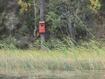
The Dog River is a good area for the observation of bald eagles. Nests have been documented and sightings were made during the first field excursion to the river. Additionally, sightings of Kingfishers, waterfowl, herons, osprey, and numerous other smaller birds are not uncommon. The area is ideal for migratory bird hunting due to its associated wetlands. Nesting boxes have been placed extensively throughout the reserve.
The area is also well known for its moose habitat and is subsequently ideal for moose hunting. There is a long history of moose hunting on the Dog River by traditional groups of hunters.
6.2 Fishing – General (f00)
Dog Lake and Dog River have documented populations of Walleye and Northern Pike. The fishing season on Dog Lake is May 4th to September 30th and February 15th to March 15th. There is some excellent Walleye fishing on the Dog River, with average size fish being 2 lbs, with larger fish up to 8-10 lbs.
Dog Lake has been researched for the reason of stocking this lake with Lake Trout and Splake in order to increase the recreational opportunities of a notably, underused lake for its size. An Environmental Assessment with public consultation, determined that the lake could sustain the increase activities associated with stocking this lake. The project was to go ahead in May 1999. The lake was stocked in 1999 and 2000. The lake is stocked on a put-grow-take basis; and no known natural reproduction is believed to occur.
6.3 Canoeing (B02)
The Dog River remains a navigable waterway and canoe route. The Savane River, Dog River, the West Side of Dog Lake, and the Kaministiquia River at one time was a major voyageur route to the west. Also associated with this activity is back country camping defined as canoe tripping, and backpacking in remote areas, accessible only on foot or by manually powered craft
(Thunder Bay District Land Use Guidelines, 1983). While no campsites were visible from the water or documented for the site there is potential for this, as has been suggested by the Ontario Land Inventory mapping project (1963).
7.0 Analysis
7.1 Feature significance – high
It is important to note that the new conservation reserves and parks identified through Ontario’s Living Legacy Land Use Strategy (1999) were chosen based on their representation of landforms and vegetation types found in Ontario. Inherently, the site has some feature significance. Geowest, 2000, suggests that the Dog River is one of the best, most complex examples of a meandering stream in Ontario
. Geowest has designated the site as provincially significant as it provides representative examples of post-glacial Lake Keweenaw and recent fluvial processes within the Quetico Subprovince.
7.2 Feature sensitivity to recreation use
Despite the dam at the head of the Kaministiquia River and Dog Lake, the river channel appears to be unchanged in at least the last five years (Aerial Photography, 1997). Changes to the amount of water flowing out of the Dog Lake System for an extended period of time may alter the present meandering pattern of the Dog River. The wetland vegetation and its associated species are at the highest risk to recreational use through either over fishing and hunting or shoreline damage.
7.3 Feature sensitivity to resource development
The Archeological Features found in the Dog River Conservation Reserve boundaries have already been disturbed by man-made changes to the water levels in the Dog River system, namely by the dam at the head of the Kaministiquia River. Tourism development on the shores of the Dog River Conservation Reserve would certainly increase the number of visitors to the area and the probability of further damage to these cultural heritage sites found on shoreline locations.
Wetland vegetation and species would be most impacted by Tourism Development on the shores of the Dog River conservation Reserve. Dog River and its associated provincially significant wetland is the habitat for migratory birds and both small and large land animals such as beavers and moose. At least one Bald Eagle nest has been located in the conservation reserve. A bald eagles nest is regarded as a sensitive site, which should be protected from future development or timber operations. While recreational camps do exist in the area, increased activity in this area may force the migration of these animals.
4.4 Cultural/historic and archeological features
The Dog River is a known heritage canoe route and contains numerous archeological sites associated with the voyageurs. Cultural remains and artifacts have been collected from these sites and should be protected from human interference.
8.0 Future considerations
8.1 Recommendations and future research
Present levels of usage should be allowed to continue. Increased usage should be monitored for effects.
An attempt to obtain more information about the fish populations and their spawning behaviors in the Dog River should be made in order to ensure sound resource management decisions.
A partnership with the hydro company should be established in an effort to maintain ideal water levels and habitat components during critical fish spawning times.
8.2 Future management
Management direction for the Dog River Conservation Reserve will be provided by a statement of conservation interest which will be prepared by the Thunder Bay District Office of the Ontario Ministry of Natural Resources in 2001.
9.0 References
Canadian Land Inventory Recreational Assessment 1968.
Mulrooney, Dan (2000) Ontario’s Living Legacy Guidelines for Recreational Resource Assessment Version 1 – September, 2000. Ontario Parks, Planning and Research Section.
O’Leary, Dennis et al. (2000) Earth Science Inventory Checklist – Dog River Conservation Reserve.
O’Leary, Dennis et al. (2000) Life Science Inventory Checklist – Dog River Conservation Reserve
Ontario Ministry of Natural Resources (1999) Ontario’s Living Legacy – Land Use Strategy. Ross, Bill (2000) Regional Archeologist – Ministry of Citizenship and Recreation.
Whyte, Pamela (2000) Whyte, Pamela (2000) Dog River Conservation Reserve Recreational Inventory. Ministry of Natural Resources, Thunder Bay District.
Appendix I: Recreation inventory checksheet
[link no longer active]
Appendix III: Dog River Conservation reserve recreation inventory C2264
September 2000
W. Pamela Whyte
Resource Manager – Thunder Bay district
Dog River Conservation Reserve Recreational Inventory
Employee Name: Pamela Whyte Date: September 26, 2000
Dog River Conservation Reserve C2264
Thunder Bay District – Shebandowan/ Spruce River Areas
Township : Part of Parry Township
Description of the site:
The Dog River Conservation Reserve (DRCR) is located approximately 60 km north-west of Thunder Bay beginning at the Northwest Bay of Dog Lake. The reserve is approximately 2,658 h2.
The land base of the Dog River Conservation Reserve is composed, superficially, of mostly lacustrine deposits. The vegetative cover is a mixture of open wetland, deciduous, coniferous, and mixed coniferous-deciduous forests. The area is documented as a provincially significant wetland, fisheries, and wildlife (moose) habitat.
Methodology:
This inventory was completed by a site visit by boat, Shebandowan and Spruce River forest value information maps, archaeological consultation, air photo’s, and district trapper and fishery information and input from District staff (Dennis Bonner, Peter Wiltsey, Tracy Moore and Rick Gollat).
Field notes:
The entire DRCR was not covered during the site visit. The southern shore of the site was traced by boat - human built structures and artificial changes to the natural landscape were noted, photographed and located using a GPS unit. The actual Dog River portion of the reserve was also inventoried for structures and changes noting the same information.
Summary of Area Description and Land Use Intent:
Summary of Area Description and Land Use Intent provided in Appendix A of the Land Use Strategy, July 1999, with specific reference to recreation uses and features states that no Land Use intent is recorded for this site.
Part 1 – Basic recreation opportunities
Backcountry camping. Yes
Backcountry camping is defined as including canoe tripping, and backpacking in remote areas, accessible only on foot, or by manually powered water craft (Thunder Bay District Land Use Guidelines, 1983).
Canoeing. Yes
The Savane River, Dog River, west side of Dog Lake and the Kaministikwa Rivers are linked in an established canoe route.
Hiking. Yes
Excellent hiking opportunities exist along old road networks located on the West Side of Dog Lake adjacent to the mouth of the Dog River. The Creighton Bay Closure offers access at a number of locations and is particularly attractive as there is no vehicle traffic on this road system a major culvert watercrossing has been removed to eliminate vehicle traffic .
Hunting. Yes
# of Hunters Seen: 2.
The area is ideal for migratory bird hunting due to the associated wetland. Nesting boxes have been placed extensively within the reserve (possibly by Ducks Unlimited). The area is also well known for its concentration of moose habitat and therefore ideal for moose hunting as well. There is a long history of moose hunting on the Dog River by traditional groups of hunters.
Fishing – recreational. Yes
Dog Lake and Dog River have documented populations of Walleye and Northern Pike. The fishing season on Dog Lake is May 4th to September 30th and February 15th to March 15th. There is some excellent walleye fishing on the Dog River, with average size fish being 2#+, with larger fish up to 8-10 lbs. reasonably common in the past.
Dog Lake has been researched for the reason of stocking this lake with Lake Trout and Splake in order to increase the recreational opportunities of a notably, underused lake. An Environmental Assessment with public consultation determined that the lake could sustain the increase activities associated with stocking this lake. The project was to go ahead in May 1999. The lake was stocked in 1999 and 2000. The lake is stocked on a put-grow-take basis; no known natural reproduction is believed to occur.
Concerns were raised about competition and habitat due to the Hydro dam that controls the level of the Lake. The annual water fluctuation of this lake 4 m with the annual high and low typically occurring in the late spring and late winter.
Lakes: Yes
The conservation is partially on Dog Lake (Northern Bay).
The lake has been classified as cool water, which is considered a suitable habitat for trout introduction
Swimming opportunities: Yes
The Reserve is made up mostly of wetlands along the water’s edge. Swimming may be an option in areas where beaches or bedrock outcrops exist (few beaches exist through the site – noted on values map). Other opportunities may exist where outposts and hunters have built cabins and docks. The Dog River itself would not be considered suitable for swimming.
Beaches: Yes
Small beaches do exist along some shorelines at the mouth of the Dog River and Dog Lake.
Rapids/waterfalls No Rapid exist much higher in the Dog River system, outside the bounds of the CR.
Bird Watching: Yes
The Dog River is a good area for sightings of bald eagles. Nests have been documented and sightings were made during the field excursion to the river. Additionally, a sighting of Kingfisher, waterfowl, herons, osprey, and numerous other smaller birds is not uncommon.
Part 2 – Human influences
Established campsites No Campsites were not visible from the water or documented throughout the site. There is potential for this and is outlined on the OLI map included (subclass n - lodging or k – camping).
Established canoe routes Yes The Dog River area is recorded in a sensitive area report. The Savane River, Dog River, west side of Dog Lake and the Kaminisikwia River were linked once as a major voyageur route to the west. The area is considered a sensitive area because the route is full of evidence of its historical significance. There are sites along it that are of considerable significance for their wildlife and waterfowl, archeologic and scenic value. It remains a navigable waterway and a used canoe route. (see values map)
Portages: No
There are no portages within the CR.
Snowmobile trails: Yes
Snowmobiles are used extensively on the Dog River in the winter months.
ATV trails: Yes
Former timber roads are being used for access to the Rec camp on the oxbow lake – The bridge has been removed and access is by ATV only.
Existing informal: Yes
Access points
Access can be made by any point along the shoreline of the reserve. Informal access points may also be found at the outside edge of the site by old forest operation roads (These roads have not been driven for this report and their condition is not known).
Existing formal access: No
Point (road & parking)
There are no formal access points to this site.
Existing boat caches: Yes
# of boat caches: 1
A limited number of shoreline locations are suitable for boat caches. (see values map) i.e. has to be a location accessible by road, which is the limiting factor.
Hunt camp/private: Yes
# of Camps 3.
Recreation camps
The area is a wetland and creates habitats for moose and waterfowl. Three cabins encountered each of which have Land use permits and leases held by private individuals.
Trapping: Yes
# trappers: 2
# trap lines: 2
The two traplines are active traplines. Beavers, Otters, Martens, fishers, and muskrats have been taken within the area.
Trapper cabins: Yes
# Cabins: 2
The trap cabins were not located on the field excursion however, are believed to exist by information kept by the ministry. (See values map)
Resort/lodge in park: No
Access to this reserve land is limited – no resorts have been established in the area.
Resort/lodge adjacent to park: Yes
Dog Lake Resort is located on a bay off at the south shore of East Bay on Dog Lake.
Outpost camp in park: No
Outpost camps are not found in this area.
Outpost camps adjacent to park : No
There are no outpost camps adjacent to this conservation reserve.
Historic sites/structures:Yes
As part of a major voyageur and native canoe route, the site has numerous archaeological sites. (see values map). Most of the sites have been damaged by artificially high water levels and are not easy to find.
Mining: No
There are no active claims in this area.
Mining adjacent to park: No
There are no active claims adjacent to the park. Current mining No exploration Current mining exploration is not evident or documented.
Evidence of past exploration: No
There is no evidence of past mining exploration.
Inholdings: No
There are no private lands within the boundaries of the conservation reserve.
Transmission lines: Yes
A hydro wire crosses the DRCR half way up the dog river system – crossing the river.
Rights-of-way. Yes
The hydro line will have an associated right-of-way (passage cleared) through the site.
Towers: No
There are no towers in the DRCR.
Wild rice harvesting: No
There is no wild-rice harvesting or areas known to exist in this area.
Roads: Yes
A number of old logging roads do cross into the boundary of the reserve. Roads are for the most part not driveable. They have fallen trees and vegetation is growing in. The roads indicated on the map (of any classification are most likely ATV trails at this time.
Additional comments:
The Dog River portion of the reserve lies on glaciolacustrine deposits and has construction challenges (poorly drained areas make it susceptible to flooding and compaction). The Southern shore of the Dog River meeting Dog Lake is bedrock, which has its own problems, related to construction (cost of bedrock excavation).
The Canadian Land Inventory Recreation Map has classified the shoreline of Dog River and Dog Lake to be of moderate to moderately low capability for recreational activity meaning it could sustain moderate to low dispersed land usage throughout the year. Recreational opportunities include: upland and waterfowl viewing, historic and prehistoric sites, affords the opportunity for angling and boating activities as well as camping and beach activities.
Recommendations:
The site would be sensitive to human development and abuse after evaluation of its surficial geology and results from the recreation index mapping. In addition, cultural heritage sites along the route should be protected from incompatible development and activity.
The activities will most likely be of an aquatic and shoreline nature (i.e. Canoeing, camping, fishing, duck hunting) in this reserve as opposed to a terrestrial based usage.
Present levels of use should be allowed to continue. Increased use should be monitored for effects.
A partnership with the hydro company should be established in an effort to maintain ideal water levels and habitat components during critical fish spawning times.
Sources:
Field Visit (September 2000)
MNR’s NRVIS values information
CLI Recreation Map Mollard and Mollard (1980) Ontario Geologic Survey – Northern Ontario Engineering Geology Terrain Study 40 – Kaministikwia Base Map.
Archeological Survey of Canada – Bill Ross (Archaeologist – Northwest Region)
Appendix IV: Natural heritage area – Life science checksheet
Natural heritage area - Life science checksheet
-
Name Dog River Conservation Reserve (C2264) Map Name Raith Map Number 52A13 UTM Ref. 5417000N 307000E County District of Thunder Bay Lat. 48° 55’ Long. 89° 37’ NAD 27 Min. Alt. 450 m Max. Alt. 460 m Locality Dog Lake Township N/A Area 2,658 ha Ownership Crown MNR Region Northwest Ecoregion and Ecodistrict 3W – 2 Landform Unit (s) Weakly to moderately broken ground moraine; fluvial lacustrine deposits; weakly broken beach and ice-contact deposits MNR District Thunder Bay Aerial Photographs Year - Roll – Flight Line – Numbers 97 4828 61 - 101 & 102 96 4829B 15 - 68, 69, 70 & 71 97 4829 61 – 55, 56, 57 & 58 97 4830 62 – 46 & 47 00 1 – 217 & 218 00 1 – 242, 243, 244 & 245 Location map

Physical and biological features
Representation
The Dog Lake Conservation Reserve (C2264) is comprised of the Dog River and associated fluvial features and adjacent uplands from its outlet into Dog Lake upstream for approximately 10 kms to the vicinity of Block Creek. The valley bottom is comprised of deltaic, sandy fluvial-lacustrine deposits flanked by weakly to moderately broken ground moraine. The low gradient of the river and nature of the sandy deltaic material have resulted in a strongly meandering channel pattern with numerous serpentine meander loops, point bars, oxbow lakes, meander scrolls, and abandoned channel segments. Gradual in-filling of old channel segments and oxbow lakes has led to the development of a highly diverse mosaic of wetland communities including various marsh complexes as well as black spruce, larch and cedar coniferous swamps and thicket swamps. Adjacent valley- bottom forest communities are also highly diverse including dense jack pine stands, mixedwood stands with various components of pine, spruce, aspen and birch, and deciduous-dominated stands of aspen and birch.
Dense coniferous stands dominated by jack pine with occasional occurrences of white and black spruce, aspen and birch occur on deep, well-drained fluvial lacustrine deposits bordering the river channel (Vegetation Type V17 – Jack Pine Mixedwood / Shrub Rich, and Vegetation Type V29 – Jack Pine / Ericaceous Shrub / Feathermoss; see Sims et al. 1997). The understory is generally diverse, dominated by shrub species such as Alnus crispa, Vaccinium myrtilloides, Ledum groenlandicum and Corylus cornuta, and herbaceous and low woody species such as Cornus canadensis, Linnaea borealis and Lycopodium spp. Feathermosses such as Pleurozium schreberi and Ptilium crista-castrensis are commonly significant components of the forest floor.
Mixedwood and deciduous-dominated forest stands are also common in the valley bottom and adjacent gently sloping morainal uplands (Vegetation Type V4 – White Birch Hardwood and Mixedwood, and Vegetation Type V9 – Trembling Aspen Mixedwood). Deciduous-dominated mixedwood stands tend to be quite variable in overstorey composition, with either trembling aspen or white birch being the dominant deciduous component, with lesser incidence of various coniferous species such as jack pine, white spruce and balsam fir. The understories are generally diverse, including species such as Corylus cornuta, Diervilla lonicera, Alnus crispa, Rubus idaeus, Prunus pensylvanica Cornus stolinifera, Cornus canadensis, Aster macrophyllus, Rubus pubescens, Pyrola spp. and Calamagrostis canadensis. Moss cover is generally low with patches of feathermoss such as Pleurozium schreberi and Ptilium crista-castrensis.
Depressional or lowland sites with thin to moderately thick organic veneers overlying morainal or lacustrine deposits are generally dominated by black spruce with occasional occurrences of jack pine, balsam fir, tamarack and white birch (Vegetation Type V33 – Black Spruce / Feathermoss, and Vegetation Type V34 – Black Spruce / Labrador Tea / Feathermoss (Sphagnum). Ericaceous species typically dominate the understory with a prevalence of Ledum groenlandicum, Vaccinium myrtilloides, and Gaultheria hispidula. Common herbaceous species, with generally lower cover, include Cornus canadensis, Lycopodium spp., Linnaea borealis and Carex spp. The forest floor is primarily covered by a continuous mat of feathermoss with patches, often extensive, of Sphagnum spp.
A highly diverse assemblage of wetland communities has developed in the complex fluvial environment of the Dog River floodplain. These vary from open-water marsh communities to conifer and thicket swamps. Various open-water vegetation communities occur in association with the river channel and the adjacent floodplain, including oxbow lakes and abandoned channel segments. Plant species composition is highly variable, depending on the water flow regime, water depth and substrate type. Field sampling was not conducted in these wetland sites, therefore only a general description of community types can be provided based on casual observations and a review of the aerial photos.
Open-water marsh communities occur in the shallow oxbow lakes and stagnant water environments that have been permanently cut off from the main river channel. Species composition varies with water depth and flooding regime, but frequently includes various submergents and floating-leaved plants such as pondweeds (Potamogeton spp.), milfoils (Myriophyllum spp.) and pond lily (Nuphar variegatum).
Marsh communities are also common and are often dominated by a single species. Cattails (Typha spp.) or sedges (Carex spp.) often dominate fringes of oxbow lakes, stagnant pools, and backwater channel areas. Bulrushes (Scirpus spp.) are more common along channel margins and also form extensive beds at the mouth of the river as it flows into Dog Lake.
Transitional areas between drier upland forest and wetter marsh habitats are often comprised of a narrow band of thicket swamps. Tall shrubs such as speckled alder (Alnus rugosa) or willow (Salix spp.) generally dominates these communities, as well as a variety of other shrubs such as Cornus stolonifera and Rubus idaeus. Graminoids such as bluejoint grass (Calamagrostis canadensis) and sedges (Carex spp.) generally dominate the herb layer, especially on more open sites.
Condition
The Dog River site is located approximately 55 km northwest of the City of Thunder Bay. The Conservation Reserve can be accessed by boat from the North Bay of Dog Lake. Numerous private forestry roads running from highways 17 and 527 provide access to the adjacent upland areas.
The Dog River floodplain and valley floor is generally undisturbed except for a transmission line right-of-way that traverses the valley to the south of the Block Creek confluence. The uplands to the east and west of the river have been extensively logged, and some of the cutblocks to the east occur within the Conservation Reserve boundary.
An Ontario Power Generation water control structure located at the outlet of Dog Lake on the Kaministiquia River maintains the stability of lake water levels, as well as those in the lower portions of the Dog River. Higher year-round water levels in the lower river reaches may have altered the vegetation succession dynamics in the floodplain to some extent.
Diversity
Table 1 provides a comparison of landform vegetation types identified in the gap analysis versus what was found during the reconnaissance field inventory program and through reviewing the forest cover maps and air photographs.
A variety of landform/vegetation complexes occur within the Dog River Conservation Reserve. Also present are numerous small water bodies and associated wetlands as well as extensive shoreline habitat within the floodplain of the Dog River. Upland forests are comprised of a variety of deciduous, deciduous mixed, conifer and conifer mixed stands. Landform types represented include weakly to moderately broken ground moraine, fluvial lacustrine deposits and sandy outwash deposits. Various wetland communities are also represented; varying from treed and semi-treed fens and thicket swamps to marsh and open water marsh communities. Numerous fluvial landform features are also present, as well as a number of small water bodies formed from meander cut-offs and abandoned channel segments.
Ecological considerations
Upland vegetation cover within the site is characteristic of the surrounding area and is predominantly fire- origin, mature mixedwood forest. Soil thickness, texture and drainage tend to influence forest species composition, with coniferous-dominated stands being more prevalent on well drained, sandy fluvial terraces, and poorer drained depressional areas, and deciduous-dominated stands occurring more commonly on warmer aspects and upper slopes. Forest stands tend to be fairly mature throughout the site, with few younger age classes represented.
The interspersion and gradient of open water, marshland, early seral floodplains, riparian forests, and upland forests within the Dog River site obviously provides habitat for a number of wildlife species and species guilds. The dense jack pine forests provide necessary habitat for forest-interior and forest-dependent upland species such as pileated woodpecker and flying squirrel. The fluvial system associated with the river and tributary creeks also provide early seral forested environments that are used by ecotonal obligates such as black bear and moose. Two registered traplines overlap with this site; showing recorded harvests of beaver, marten, muskrat, otter, and fisher. A number of wetland and riverine habitats provide extensive nesting and staging habitat for waterfowl. Numerous wood duck nest boxes have been erected along the length of the river. Although very little fisheries information is documented, there is extensive suitable habitat for spawning walleye in the form of seasonally flooded riparian marshes.
Dog River drains the area to the north of Dog Lake, including Lac des Iles and west to Muskeg Lake. The river is fed from the north by Block Creek, Riviere des Isles, East Dog River, Jordan, Muskeg, Jack, Mirage and Sharp creeks, and from the south by Fisher Creek. Dog Lake is drained by the Kaministiquia River, which flows south into Lake Superior.
Special features
No evidence of vulnerable, threatened or endangered species, or
S
ranked species were encountered during the reconnaissance survey of the site.Field survey
The Dog River Conservation Reserve was inventoried on October 3, 2000. Three sites were surveyed throughout the area, all by boat access. In addition, the area was viewed by helicopter and photographed on October 6, 2000. A surficial geologist, a vegetation ecologist and a wildlife biologist completed the reconnaissance inventory. An Earth Science Checklist has also been prepared for the Dog River Conservation Reserve.
table 1. landform/vegetation types Landform Types: Parent Material Landform Types: Surface Expression Vegetation Types: Deciduous Vegetation Types: Deciduous Mixed Vegetation Types: Conifer Mixed Vegetation Types: Conifer Vegetation Types: Sparse Forest Vegetation Types: Treed Wetland Vegetation Types: Opened Wetland Ground Moraine Weakly broken * ✔* ✔* ✔* ✔* * Ground Moraine Moderately broken * * * * * Ground Moraine Strongly broken Bedrock Weakly broken ✔ ✔ Bedrock Moderately broken Bedrock Strongly broken End Moraine Weakly broken End Moraine Moderately broken End Moraine Strongly broken Outwash Deposits Weakly broken Outwash Deposits Moderately broken Outwash Deposits Strongly broken Beach/Aeolian Deposits Weakly broken * Lacustrine Deposits N/A * ✔* ✔* ✔* ✔* ✔* Esker N/A ✔Indicates that LV type found within study area during reconnaissance survey.
*Gap Analysis suggests that particular Landform/Vegetation (LV) type occur within study area
Major information sources
Baldwin, K. A. and R. A. Sims. 1997. Field guide to the common forest plants in northwestern Ontario. Ont. Min. Natur. Resour., Northwest Sci. & Technol. Thunder Bay, Ont. Field Guide FG-04. 359 pp.
Harris, A.G., S.C. McMurray, P.W.C. Uhlig, J.K. Jeglum, R.F. Foster and G.D. Racey. 1996. Field guide to the wetland ecosystem classification for northwestern Ontario. Ont. Min. Natur. Resour., Northwest Sci. & Technol. Thunder Bay, Ont. Field Guide FG-01. 74 pp. + Append.
Noble, T.W. 1979. Life Science report, Phase II, Site Region 3W, North Central Region. Ontario Ministry of Natural Resources.
Sims, R.A., W.D. Towill, K.A. Baldwin, P. Uhlig and G.M. Wickware. 1997. Field guide to the forested ecosystem classification for northwestern Ontario. Ont. Min. Natur. Resour., Northwest Sci. & Technol. Thunder Bay, Ont. Field Guide FG-03. 176 pp.
Field Reconnaissance, Oct. 2000.
Ontario Ministry of Natural Resources trapline information for 1999.
Significance Level (Provincial/Regional/Local) and Brief Summary of Major Representative Values
Provincially Significant: The site provides a good example of a low gradient, strongly meandering river with numerous well developed fluvial features such as meander loops, oxbow lakes, meander scrolls and point bars. It is also representative of upland areas within Site District 3W - 2.
The extensive and diverse complex of wetland communities provides provincially significant moose habitat.
Significant walleye spawning habitat along majority of the river length.
The Dog River is of historical importance as it was a canoe route to the west used by fur traders.
Date Compiled: November 1, 2000
Compiler (s):
J. Bentz, A. Saxena, D. O’Leary
Geowest Environmental Consultants Ltd.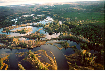
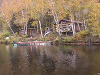
Plate 1. Dog River Conservation Reserve. 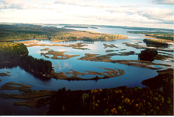
Plate 2. Mouth of Dog River at the inlet to Dog Lake. 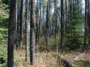
Plate 3. Vegetation Type V17 – Jack Pine Mixedwood / Shrub Rich on sandy, fluvial lacustrine sediments adjacent Dog River 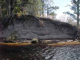
Plate 4. Fluvial lacustrine (deltaic) sediments exposed near the mouth of the Dog River. Conifer dominated mixedwood forest types common along river. Dog River Conservation Reserve (C2264) - Species List
footnote 1 Trees
Scientific Name
Common Name
Abies balsamea
balsam fir
Betula papyrifera
white birch
Larix laricina
tamarack
Picea glauca
white spruce
Picea mariana
black spruce
Pinus banksiana
jack pine
Populus tremuloides
trembling aspen
Shrubs
Scientific Name
Common Name
Alnus crispa
green alder
Alnus rugosa
speckled alder
Arctostaphylos uva-ursi
bearberry
Chamaedaphne calyculata
leather leaf
Cornus stolonifera
red osier dogwood
Corylus cornuta
beaked hazel
Diervilla lonicera
bush honeysuckle
Kalmia polifolia
bog laurel
Ledum groenlandicum
Labrador tea
Linnaea borealis
twinflower
Oxycoccus microcarpus
small cranberry
Prunus pensylvanica
pin cherry
Ribes spp
currant
Rosa acicularis
prickly wild rose
Rubus idaeus var. strigosus
wild red raspberry
Rubus pubescens
dwarf raspberry
Salix spp
willow
Vaccinium myrtilloides
velvet leaf blueberry
Viburnum edule
squashberry
Herbs
Scientific Name
Common Name
Aster ciliolatus
ciliolate aster
Aster macrophyllus
large-leaved aster
Circaea alpina
dwarf enchanter’s nightshade
Clintonia borealis
blue bead lily
Cornus canadensis
bunch berry
Fragaria virginiana
common strawberry
Galium triflorum
fragrant bedstraw
Petasites palmatus
sweet coltsfoot
Pyrola asarifolia
pink pyrola
Pyrola secunda
one-sided pyrola
Graminoids
Scientific Name
Common Name
Calamagrostis canadensis
blue-joint grass
Carex spp
sedge
Schizachne purpurascens
false melic grass
Scirpus spp
bulrush
Typha latifolia
cattail
Ferns and fern-allies
Scientific Name
Common Name
Athyrium filix-femina
lady fern
Dryopteris carthusiana
spinulose wood fern
Equisetum arvense
field horsetail
Lycopodium annotinum
stiff clubmoss
Lycopodium complanatum
ground cedar
Lycopodium obscurum
ground pine
Bryophytes and lichens
Scientific Name
Common Name
Aulacomnium palustre
ribbed bog moss
Brachythecium
salebrosum
Cladina spp
reindeer lichen
Dicranum spp.
broom mosses
Hylocomium splendens
stair-step moss
Pleurozium schreberi
Schreber’s moss
Ptilium crista-castrensis
plume moss
Sphagnum spp
Appendix V: Earth science inventory checklist
Earth science inventory checklist Name: Dog River Conservation Reserve (C2264) Map Name: Raith NTS No. 52A13 UTM Reference: 5417000N 307000E OBM No. 163205410 163005420 163105410 Latitude: 48°55’ Longitude: 89°37’ Elevation (Max) 460 m Elevation (Min) 450 m County: District of Thunder Bay Township: NA Lot: NA Concession: NA Area: 2,658 ha Air Photos 97 – 4828 61 – 101 and 102 96 – 4829B 15 – 68, 69, 70 and 71 97 – 4829 61 – 55, 56, 57,and 58 97 – 4830 62 – 46, and 47 00 – 1 – 217 and 218 00 – 1 – 242, 243, 244 and 245 MNR Region: Northwest MNR District: Thunder Bay Park Zone: Northwest Survey Type: Reconnaissance Location map
An image of Northwestern Ontario Earth science features
The Dog River Conservation Reserve (C2264) is approximately 55 km northwest of the City of Thunder Bay, Ontario. The Conservation Reserve is generally accessed by boat from the North Bay of Dog Lake. Numerous private forestry roads running from both highways 17 and 527 provide access to the adjacent upland areas.
The area is comprised of the Dog River and associated fluvial features and adjacent uplands from its outlet into Dog Lake upstream. The low gradient of the river and nature of the sandy deltaic material have resulted in a strongly meandering channel pattern with numerous serpentine meander loops, point bars, oxbow lakes, meander scars, and abandoned channel segments. Gradual in-filling of old channel segments and oxbow lakes has led to the development of a highly diverse mosaic of wetland communities including various marsh complexes as well as black spruce, larch and cedar coniferous swamps and thicket swamps.
Dog River drains the area to the north, including Lac des Iles and west to Muskeg Lake. It is fed from the north by Black Creek, Riviere des Isles, East Dog River, Jordan, Muskeg, Jack, Mirage and Sharp creeks and from the south by Fisher Creek. Ontario Power Generation (OPG) has a long-term monitoring station at Silver Falls which provides a historical record of water levels within Dog Lake from 1959 to present. These records suggest that Dog Lake has varied 4.01 m, with a minimum value of 417.50 m (April 15 – 17, 1980) and a maximum value of 421.51 m (September 22, 1977). Minimum values generally occur in April (~ 418.64 m) with maximum levels being obtained in July (~ 420.72 m). OPG established a remote monitoring station in Dog River upstream where Jordain Creek flows into the river. Records since August 4, 1999 show water levels within the river have fluctuated between 98.59 m and 98.90 m, a difference of only 0 .31 m. Minimum values were reached on August 29, 30 and 31, 1999 and maximum values were recorded on May 6, 2000.
The Dog River Conservation Reserve is found within the Quetico Subprovince of the Superior Structural Province (Thurston 1992a; Ontario Geological Survey 1991(a); Card et al. 1993). The Superior Province is the largest Archean craton in the world and is characterized by easterly trending belts of Archean supracrustal volcanic and sedimentary rocks separated by large areas of granitic rocks (Thurston 1992b; Davidson 1981). The Quetico Subprovince is a sedimentary basin characterized by linear structures that tend easterly contrasting with the curvilinear structures in the granitic terrains beyond the borders of the subprovince (i.e., Wabigoon and Wawa Subprovinces). The rocks are highly metamorphosed sediments, migmatites, granitized gneisses, and gneissic or massive grantic rocks of approximate granodiorite composition (Stockwell et al. 1968).
Regionally, the Quetico Subprovince is composed of highly metamorphosed sediments, migmatites, granitized gneisses, and gneissic or massive grantic rocks of approximate granodiorite composition (Stockwell et al. 1968. However, the Dog River Conservation area is underlain mainly by muscovite bearing granites, granodiorite and metasediments (Ontario Geological Survey 1991(b)). Some differences (of opinion) were noted in the northern portion of the Conservation Reserve. While Kaye (1969) has mapped the upper end of the Conservation Reserve (near the confluence of Dog River and Block Creek) as being underlain by metasediments and metavolcanics consisting of boulder conglomerate, feldspathic sandstone, greywacke, and biotite quartz, the Ontario Geological Survey (1991(b)) has mapped the area as being underlain by granodiorite and granites. Pye and Fenwick (1965) also support this mapping. With the exception of the far southern portion of the Conservation Reserve, the bedrock is overlain by thick post-glacial sediments and does not influence site characteristics.
Various hypothesis regarding the exact glacial history of the area have been put forward, much of it quite contradictory. Recent work by Barnett (1992) suggests that the Dog River area was ice-free somewhere around 10 kaBP (end of the Late Wisconsinan). Labrador Sector ice covered the area from 18 kaBP (Nissouri Stade) until approximately 11 kaBP (post Greatlakean Stade) and 10 kaBP (initiation of Holocene). Around 10 kaBP, the ice sheet was located to the north and east of the Dog Lake / Dog River area. As well, glacial Lake Kaministikwia was formed at the lower end of Dog Lake along the Kaministikwia River. By 9 kaBP, the ice had retreated north of Lake Nipigon. Barnett (1992) suggests that outlets along the Seine-Kashabowie and possibly Dog River valleys allowed glacial Lake Agassiz waters to drain into the Lake Superior basin. However, earlier work by Prest (1968) suggests that the area may have been ice-free as early as 11.25 kaBP, coinciding with the late Wisconsinan North Bay Interstadial and Algonquin Stadial (Davidson 1981; the North Bay Interstadial and Algonquin Stadial are not recognised by Barnett (1992). Circa 12.2 kaBP, the Dog Lake area represents the northern extent to glacial Lake Keweenaw, formed in the far-western portions of the Lake Superior basin (Prest 1968). Zoltai (1965b) has mapped the Dog River as a glacial spillway leading into Dog Lake and subsequently into the Kaministikwia spillway, south into Lake Keweenaw (current day Lake Superior). Field observations by Zoltai (1965b) do not support Elson’s (1957) or Barnett’s (1992) hypothesis that the Dog – Kaministikwia spillway was an outlet of Lake Agassiz. At that time, glacial Lake Agassiz (Norcross to Campbell phase) extended eastward to approximately 50 km north and west of Dog Lake and appeared to reach its most eastern extent near Lac des Milles Lacs. Zoltai (1963) states
my preliminary investigations north of Dog Lake indicate that the Kaministikwia – Dog River spillway was functioning to carry away the meltwater from the neighbourhood of the Kaiashk moraine, rather than serving as an outlet of Lake Agassiz.
The gap analysis suggests that mainly lacustrine deposits surrounded by weakly broken ground moraine characterise the Dog River Conservation Reserve. Table 1 provides a comparison of materials identified in the gap analysis versus materials identified during the reconnaissance field inventory and subsequent air photo interpretation exercise.
Barnett et al., (1991) and Mollard and Mollard (1981) have mapped the area as consisting primarily of a sandy alluvial plain (in the main channel) with adjacent sandy lacustrine plains and sandy ground moraine on adjacent upland areas. Zoltai (1965a) has mapped the area as deltaic sands and adjacent upland areas as being silty to sandy ground moraine. Field surveys by Geowest support the previous mapping completed for the area, however, bedrock controlled topography with thin morainal materials is typical at the south end of the Conservation Reserve near
Table 1. Comparison of landform types identified by gap analysis and reconnaissance inventory and mapping Landform Types Parent Material Landform Types Surface Expression Landform Types Suggested by Gap Analysis Landform Types Found During Reconnaissance Inventory and Mapping Ground Moraine Weakly broken yes yes Ground Moraine Moderately broken yes no Ground Moraine Strongly broken no no Bedrock Weakly broken no yes Bedrock Moderately broken no no Bedrock Strongly broken no no End Moraine Weakly broken no no End Moraine Moderately broken no no End Moraine Strongly broken no no Outwash Deposits Weakly broken no no Outwash Deposits Moderately broken no no Outwash Deposits Strongly broken no no Beach/Aeolian Deposits Weakly broken no no Lacustrine Deposits N/A yes yes Esker N/A no no Fisher creek
All sites visited suggested that the materials (adjacent the channel) were of a fluvial/lacustrine (possibly deltaic) origin. The upland areas adjacent the mid-section of the river consist of moderately coarse- textured ground moraine. Other significant features delineated include a major beach ridge, and numerous ice contact features.
The fluvial lacustrine materials were well drained and consisted of yellowish brown to reddish brown, very fine to fine sand. No coarse fragments were noted at any of the sites. The materials were often well stratified and are expected to be greater than 5 m in thickness as exposures of 3 m (Plate 1) were noted near the mouth of the river. These materials have been mapped as unit 4b(d) (see attached map legend). It is speculated that finer- textured lacustrine materials occur towards the northern end of the Conservation Reserve, where topography is flat and the area appears to be poorly drained. The presence of fine-textured lacustrine materials would result in a permanently high water table, giving rise to sub hydric conditions which support black spruce dominated communities (unit 4a).
Although no sites were established within the adjacent morainal areas, the tills described by both Zoltai (1965a) and Mollard and Mollard (1981) in the Dog Lake areas are texturally consistent with those surveyed in the Dog Lake area by Geowest (East Bay Conservation Reserve C2265). These tills have been mapped as unit 1a.
At the south end of the Conservation Reserve, thin (and often discontinuous) morainal veneers overlie moderately broken bedrock (unit 7b). It is assumed that the till materials are of similar origin as those found to the north, and hence, they most likely moderately coarse-textured (i.e., sandy loams with > 20 % coarse fragment content). Adjacent the existing shoreline, it appears that thin, discontinuous lacustrine veneers overlie smoothed granitic bedrock (unit 7d)
A significant beach ridge (unit 4e) is mapped along the western shoreline of the Conservation Reserve. This beach ridge parallels the existing channel and is approximately 950 m in length. Based on Barnett’s (1992) theory, it is speculated that this beach ridge may have been formed during a higher stage of glacial Lake. The beach ridge is approximately 20 m in height.
A number of ice contact features occur along the eastern edge of the Conservation Reserve, including an esker and three kame-like features. A small sinuous esker (unit 3c) is found adjacent the small lake in the middle of the Conservation Reserve. This esker is oriented in a northeast/southwest direction, giving support to the direction which ice retreated within the Dog Lake area. The deglacial mass wasting features kames (units 3a) occur in the far northern portion of the Conservation Reserve. It appears that these deposits are unmodified by overriding ice or by lake-action as they have maintained their classical conical form. They area approximately 50 - 75 m in height.
Numerous organic accumulations have developed immediately adjacent to the existing shoreline (unit 8b). This area is subject to annual flooding following snowmelt.
Field survey
The Dog River Conservation Reserve was inventoried on October 3. Three (3) sites were established throughout the area, all by boat access. In addition, the area was flown by helicopter on October 6, 2000. A surficial geologist (Dennis O’Leary), a vegetation ecologist (Jerry Bentz) and a wildlife biologist (Amit Saxena) completed the reconnaissance inventory. All three individuals all are from Geowest Environmental Consultants Ltd.
Mapping
A reconnaissance surficial geology map has been prepared for the Dog River Conservation Reserve at 1:20 000 to accompany this checklist. The mapping legend follows Zoltai’s (1965a) classification scheme, however, it has been modified somewhat to account for additional parent materials and topographic considerations.
Sensitivity
Access to the Dog River Conservation Reserve is limited to boat access and a number of private forestry roads from the east and west. Some of these forestry trails occur within the Conservation Reserve.
Due to the nature of the site, it should be considered highly sensitive to disturbances. A small control structure exists at the southern end of Dog Lake, moderating the flow of water into Kaministikwia River. It would appear from the 1996 and 1997 and from the field survey, the system appears to be very stable (today). There appears to be virtually no changes to the meander patterns over the past five years.
Significance
Dog River is one of the best, most complex examples of a meandering stream in Ontario. It has been designated as a provincially significant site as it provides representative examples of post-glacial fluvial lacustrine deltaic deposits associated with ancient spillways of glacial Lake Keweenaw and recent fluvial processes within the Quetico Subprovince.
Recommendations
The Dog River Conservation Reserve has been recognised as containing provincially significant wetlands (Ontario’s Living Legacy 1999). The site provides representative examples of post-glacial fluvial lacustrine deltaic deposits associated with ancient spillways to glacial Lake Keweenaw (current day Lake Superior) and recent fluvial processes. Dog River Conservation Reserve protects sediments that are representative of the Late Wisconsinan and Holocene periods. It is also recommended that water levels within Dog Lake be maintained at their current levels so as to maintain this significant feature.
References
Barnett, P.J. 1992. Quaternary geology of Ontario; in Geology of Ontario, Ontario Geological Survey, Special Volume 4, Part 2, Ontario Ministry of Northern Development and Mines. p. 1011 – 1088.
Barnett, P.J., A.P. Henry and D. Babuin. 1991. Quaternary geology of Ontario, west-central sheet; Ontario Geological Survey, Map 2554, scale 1:1 000 000. Ontario Ministry of Northern Development and Mines.
Card, K.D., J.A. Percival and B.V. Sanford. 1993. Bedrock Geology Lake Nipigon Ontario - USA, Map NM-16-G, Scale 1:100 000. Geological Survey of Canada, Energy, Mines and Resources Canada.
Davidson, R.J. 1981. A framework for the conservation of Ontario’s earth science features . Ontario Ministry of Natural Resources.
Davidson, R.J. and P.S.G. Kor. 2000. Research, mapping and reporting guidelines for earth science inventories in provincial parks, conservation reserves and areas of natural and scientific interest. Ontario Ministry of Natural Resources, Ontario Parks. Open File Earth Science Report 2000-3.
Geologic Survey of Canada. 1968. Geological Map of Canada 1250A, 1:5 000 000. Department of Energy, Mines and Resources (Geology compiled by R.J.W. Douglas, 1966, 1967).
Kaye, L. 1969. Eayrs Lake – Starnes Lake Area, Thunder Bay District Map 2172, 1:63 360. Ontario Department of Mines.
Mollard, D.G. and J.D. Mollard. 1981. Northern Ontario Engineering Geology Terrain Study 57: Kaministikwia Area, (NTS 52A/NW) District of Thunder Bay. Ontario Geologic Survey, Ministry of Natural Resources.
Ontario Geological Survey. 1991(a). Bedrock Geology of Ontario, Explanatory Notes and Legend. Map 2545. Ontario Ministry of Northern Development and Mines.
Ontario Geological Survey. 1991(b). Bedrock Geology of Ontario, West-Central Sheet. Map 2542. Ontario Ministry of Northern Development and Mines.
Ontario’s Living Legacy. 1999. Ontario’s Living Legacy Land Use Strategy July 1999. Ontario Ministry of Natural Resources.
Margaret McMahon. 2000.Ontario Power Generation, Water Resources Division. Personal Communication. Prest, V.K. 1968. Quaternary geology of Canada. in Geology and Economic Minerals of Canada. R.J.W. Douglas, Scientific Editor. Geological Survey of Canada, Department of Energy, Mines and Resources. Economic Geology Report No. 1. pp. 676 – 758.
Pye, E.G. and K.G. Fenwick. 1965. Atikokan-Lakehead Sheet Geological Compilation Series Map 2065, Scale 1:253 440. Ontario Department of Mines.
Stockwell, C.H., J.C. McGlynn, R.F. Emslie, B.V. Sanford, A.W. Norris, J.A. Donaldson, W.F. Fahrig and K.L. Currie. 1968. Geology of the Canadian Shield. In Geology and Economic Minerals of Canada. R.J.W. Douglas, Scientific Editor. Geological Survey of Canada, Department of Energy, Mines and Resources. Economic Geology Report No. 1. pp. 45 – 145.
Thurston, P.C. 1992(a). Geology of Ontario: Introduction; in Geology of Ontario, Ontario Geological Survey, Special Volume 4, Part 1, Ontario Ministry of Northern Development and Mines. p. 2 – 26.
Thurston, P.C. 1992(b). Archean Geology of Ontario: Introduction; in Geology of Ontario, Ontario Geological Survey, Special Volume 4, Part 1, Ontario Ministry of Northern Development and Mines. p. 73 – 78.
Thurston, P.C., H.R. Williams, R.H. Sutcliffe and G.M. Stott. 1992. Geology of Ontario. Ontario Geological Survey, Special Volume 4, Parts 1and 2. Ontario Ministry of Northern Development and Mines.
Williams, H.R. 1992. Quetico Subprovince; in Geology of Ontario, Ontario Geological Survey, Special Volume 4, Part 1, Ontario Ministry of Northern Development and Mines. p. 383 – 403.
Zoltai, S.C. 1963. Glacial features of the Canadian Lakehead areas. Can. Geograph. Vol. 7, No. 3, pp. 101 – 115.
Zoltai, S.C. 1965(a). Surficial Geology, Thunder Bay, Map S265 Scale 1:506 880. Ontario Department of Lands and Forests, Research Branch.
Zoltai, S.C. 1965(b). Glacial features of the Quetico-Nipigon area, Ontario. Can. J. Earth Sci. Vol. 2, No. 4, pp. 247 – 269
Date Compiled : November 1, 2000
Compiler: Dennis O’Leary, B.A.,
Surficial Geologist, Geowest Environmental Consultants Ltd.List of Plates:
Plate 1. Fluvial/lacustrine sediments near the mouth of Dog River
Plate 2. Mouth of Dog River
Plate 3. Meandering pattern typical of Dog RiverField Notes :
Site: Dog River (C2264) Plot No. 1 Date: October 3, 2000
UTM Co-ordinates: 5420005N and 307040E
Picture No. Disk 2, pictures 9 – 11 Surveyor: Dennis O’Leary, Geowest Environmental Consultants Ltd.
Notes: Thick fluvial / fluvial-lacustrine deposits; possible old beach ridge (check photos); yellowish brown to reddish brown; very fine sand to fine sand; no coarse fragments; moderately fresh; undulating (to possibly ridged - check photos) topography (0 - 5 % slopes) at site, however walked up steep embankment from river to get to site; well to rapidly drained; representative of uplands in area; site accessed by water.
Site: Dog River (C2264) Plot No. 2 Date: October 3, 2000
UTM Co-ordinates: 5417075N and 307090E
Picture No. Disk 2, pictures 12 – 13 Surveyor: Dennis O-Leary, Geowest Environmental Consultants Ltd.
Notes: Well drained fluvial-lacustrine materials; yellowish brown; loamy fine sand overlying very fine sand; no coarse fragments; moderately fresh materials; level to undulating topography (slopes < 5 %) ; Need to review photos as cutblock boundaries along east side may be within OLL boundary; discussions with OLL personnel suggest that although site may have been harvested, site will be restocked and will not be available for harvesting in future; land will remain in OLL designation; site accessed by water.
Site: Dog River (C2264) Plot No. 3 Date: October 3, 2000
UTM Co-ordinates: 5415030N and 308020E
Picture No. Disk 2, pictures 14 – 15 Surveyor: Dennis O’Leary, Geowest Environmental Consultants Ltd.
Notes: Deep fluvial-lacustrine deposits; beach ridge in site (see photo 14, disk 2); brown to reddish brown, well drained, fine sand; no coarse fragments, level topography with slopes < 5 %; moderately fresh; site accessed by water. Scirpus beds throughout water, especially in mouth; very few scirpus beds in river channel; water commonly < 2 m in depth at mouth.
System appears to be extremely stable as there was no apparent difference in photos (1996 and 1997) and today’s conditions; river and lake apparently controlled by Ontario Hydro for Kekabeka Falls hydro station.
Site may be considered provincially significant due to extensive meandering of river - although noted this pattern in a few other areas, they were nowhere as extensive and well developed with. Interesting to note the lack of visible wildlife - apparently moose are quite common, however, there was no significant evidence of populations (i.e., no hedging of desirable browse species); excellent waterfowl habitat, however very few species noted - apparently area is not on a major flyway.
Plate 1. Fluvial/lacustrine (deltaic) sediments exposed near the mouth of Dog River. Note the bedding of the sandy materials.
Plate 2. Mouth of Dog River flowing into Dog Lake.
Plate 3. Meandering pattern of Dog River (mid-section). Key words / glossary
- Alluvium:
- The detrital materials that are eroded, transported, and deposited by streams.
- Algonquin stadial:
- A short-lived cold period occurring approximately 11,000 to 10,000 years ago.
- Archean:
- A term, meaning ancient, which has been applied to the oldest rocks of the Precambrian; as more physical measurements of geological time are made, the usage is changing; the term Early Precambrian is preferred.
- Craton:
- The large, relatively immobile portion of continents consisting of both shield and platform areas.
- Deltaic:
- Sedimentary deposits in a delta; an alluvial deposit usually triangular in shape, at the mouth of a river or stream.
- Erosion:
- The loosening and transportation of rock debris at the earth’s surface; the wearing away of the land, chiefly by rain and running water.
- Esker:
- A sinuous ridge of constructional form, consisting of stratified accumulations, glacial sands, and gravel.
- Fluvial:
- Pertains to or produced by the action of a stream or river.
- Glacial striae:
- Scratches commonly parallel, on smooth rock surfaces due to glacial abrasion.
- Glaciation:
- Alteration of any part of the earth’s surface by passage of a glacier, chiefly by glacial erosion or deposition.
- Greatlakean stade:
- The Greatlakean Stade, which followed the Two Creeks Interstade approximately 11,800 years ago, was a period of glacial advance; this stade is recognized in Michigan, but not in Ontario.
- Ground moraine:
- Rock material carried and deposited in the base of a glacier; also known as bottom moraine, subglacial moraine.
- Holocene:
- An epoch of the Quaternary Period from the end of the Pleistocene, around 10,000 years ago, to the present; also known as post-glacial; recent.
- Interbedded:
- Having beds lying between other beds with different characteristics.
- KaBP
- Thousand years before present
- Kame:
- A low, long, steep-sided mound of glacial drift commonly stratified sand and gravel deposited as an alluvial fan or delta at the terminal margin of a melting glacier.
- Lacustrine:
- Belonging to or produced by a lake; sediments that are deposited in a lake.
- Landform:
- All the physical, recognizable, naturally formed features of land, having a characteristic shape; includes major forms such as a plain, mountain, or plateau, and minor forms such as hill, valley, or alluvial fan.
- Meander:
- A sharp, sinuous loop or curve in a stream, usually part of a series.
- Meander belts:
- A zone along the floor of a valley across which a meandering steam periodically shifts its channel.
- Meander scar:
- A crescentic, concave mark on the face of a bluff or valley wall formed by a meandering stream.
- Metamorphic rock:
- The earth’s crust as well as being intruded by magma, is from time to time subjected to huge stresses which are sufficiently great to cause it to break to form faults, and also to bend forming folds; these forces are generally concentrated near to subduction zones; at these destructive plate margins, the rocks that form the plates are compressed, folded and heated; the result is a broad, linear zone of rocks which are altered, to varying degrees, by the high temperatures and pressures.
- Metasediment:
- A sediment or sedimentary rock which shows evidence of metamorphism.
- Moraine:
- An accumulation of glacial drift deposited chiefly by direct glacial action and possessing initial constructional form independent of the floor beneath it.
- Nissouri stade:
- The Nissouri Stade is the initial stade of ice advancing during the Late Wisconsinan; during the stade, the Laurentide ice sheet reached the Niagara Escarpment by about 23,000 years ago.
- North Bay interstadial:
- A period characterized by warmer climate and subsequent deglaciation; ~ 12 kaBP – 11 kaBP.
- Organic soil:
- Any soil or soil horizon consisting chiefly of, or containing at least 30 % of organic matter; examples are peat soils and muck soils; results from the activity of organisms such as the secretion of skeletal matter.
- Outwash:
- Sand and gravel transported away from a glacier by streams of meltwater and either deposited as a floodplain along a pre-existing valley bottom or broadcast over a pre-existing plain in a form similar to an alluvial fan; also known as glacial outwash; outwash drift.
- Oxbow:
- A closely looping, U-shaped steam meander whose curvature is so extreme that only a neck of land remains between the two parts of the stream; also known as abandoned channel.
- Oxbow lakes:
- The crescent-shaped body of water located alongside a stream in an abandoned oxbow after a neck cut-off is formed and the ends of the original bends are silted up.
- Parent material:
- The unconsolidated mineral or organic material from which the true soil develops.
- Point bar:
- One of a series of low, arcuate sand and gravel ridges formed on the inside of a growing meander by the gradual addition of accretions; also known as a meander bar.
- Relief:
- The configuration of part of the earth’s surface, with reference to altitude and slope variations and to irregularities of the land surface.
- Sedimentary rocks:
- A rock formed in the sea, rivers, lakes, glacial deposits, etc.; processes, which are active at the earth’s surface, form sedimentary rocks.
- Supracrustal:
- Rocks that overlie basement rock.
- Till:
- Unsorted and unstratified drift consisting of a heterogeneous mixture of clay, sand, gravel, and boulders which is deposited by and underneath a glacier.
- Volcanic rock:
- Finely crystalline or glassy igneous rock resulting from volcanic activity at or near the surface of the earth; also known as extrusive rock.
- Wisconsinan:
- A period between 115,000 years before present and 10,000 years before present; preceding the Holocene; divided into three stages, including Early Wisconsinan (115,000 – 60,000 years before present), Middle Wisconsinan (60,000 – 30,000 years before present) and Late Wisconsinan (30,000 – 10,000 years before present).
Footnotes
- footnote[1] Back to paragraph Partial plant species list based on a reconnaissance field survey conducted on October 3, 2000. Three field plots were established in the study area.