Esker Lakes Provincial Park Management Plan
This document provides direction on the management of Esker Lakes Provincial Park.
Approval statement
Esker Lakes Provincial Park is an area of high recreational and natural value and has since 1957 served as a popular destination point for camping, canoeing, hiking and angling enthusiasts.
We are pleased to approve the Esker Lakes Provincial Park Management Plan, as official policy for the management and development of this park. The plan reflects this Ministry’s intent to protect natural features of Esker Lakes and maintain high quality opportunities for outdoor recreation and heritage appreciation for both residents of Ontario and visitors to the Province.
R. A. Riley
Regional Director
Northern Region
N. R. Richards
Director,
Parks and Recreational Areas Branch
1.0 Introduction
Esker Lakes Provincial Park is a 3,237 hectare Natural Environment class park established in 1957 by Regulation 144/57. It is situated in Northeastern Ontario, 37 kilometres northeast of the Town of Kirkland Lake and approximately 600 kilometres north of Toronto (Figure 1). The park is located in Kirkland Lake District, part of the Northern Administrative Region of the Ministry of Natural Resources. The park is accessed via the Harker Holloway resource access road, running 17 kilometres north from Highway 66 (Figure 2).
Esker Lakes is an area of high recreational and natural value and has for three decades served as a popular destination point for carping, canoeing, biking and angling enthusiasts.
The varied topography of Esker Lakes contains a rich diversity of landforms and significant geological and vegetative features. The park is underlain by Early Precambrian volcanic bedrock, although extensive Quaternary deposits almost completely cover the park. These deposits include unconsolidated glaciofluvial sand, gravel and eolian material. The park is dominated by the segmented Munro Esker, parabolic sand dunes and numerous small dry kettles and kettle lakes. Thirty-eight of these scenic clear-water lakes dot the park landscape, providing excellent trout fishing opportunities.
Esker Lakes is located in a vegetation transition zone between the Boreal Forest Region and the Great Lakes - St. Lawrence Forest Region. The park is on the southern margin of the Northern Clay Belt, providing representation of Hill’s (1959) Site District 3E-6. Vegetation varies throughout the park from coniferous, deciduous and mixed forest stands to significant peat bog communities.
Figure 1 - Provincial setting
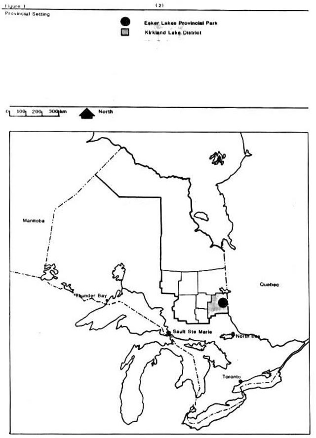
Enlarge Figure 1 - Provincial setting map (PDF)
Figure 2 - Regional setting
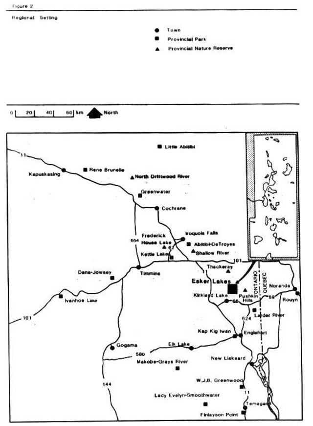
Enlarge Figure 2 - Regional setting map (PDF)
2.0 Classification
Esker Lakes is classified as a natural environment park in accordance with the 1978 Ontario Provincial Parks Planning and Management Policies. Natural environment parks contain outstanding recreational landscapes with representative natural features to provide high quality recreational and. educational experiences. The varied topography of Esker Lakes contains a rich diversity of significant geological and vegetative features including the Munro Esker, sand dunes, peatland bogs and mixed forest stands, while the park’s campground, trails and numerous lakes provide excellent recreational and educational opportunities.
3.0 Goal
The goal of Esker Lakes Provincial Park is to protect the existing park environment consisting of a rich diversity of significant geological and vegetative features while providing excellent outdoor recreational and educational opportunities.
4.0 Objectives
Esker Lakes will contribute to all four objectives of the Ontario provincial parks system including protection, recreation, heritage appreciation and tourism.
4.1 Protection
Esker Lakes contains a variety of earth and life science features, which will be protected through appropriate zoning and management.
The park contains various earth science features dating to Precambrian volcanic bedrock, but is primarily representative of surficial. Processes including unconsolidated glaciofluvial, sand, gravel and eolian features.
Features to be protected include those segments of the nationally significant Munro Esker found within the park and provincially significant dune complexes originating from unvegetated post- glacial esker ridges and Lake Barlow-Ojibway glacial sediment.
Esker Lakes is situated in Site District 3E—6 of Hills’ (1959) Ontario soil-climate- vegetation association, providing good representation of the Lake Abitibi Site Region. Twenty seven site types are present including significant representation of lake bogs, bog and dune complexes, white pine and jack pine complexes and old mixed forest stands.
4.2 Recreation
The existing Sunny Point car campground provides 33,000 camper days at 60% optimum capacity (July/August) for resident and non-resident use during the 134 day annual operating season. Existing day use facilities provide for 31,000 day user days, while more remote areas of the park provide for backcountry travel.
4.3 Heritage appreciation
The park offers structured and unstructured opportunities for visitors to appreciate the natural and cultural features of the Kirkland Lake area including glacial geomorphology, forest fire ecology and local mining camp history.
4.4 Tourism
Esker Lakes will continue to provide day-use and carping opportunities for both local residents and tourists, principally than northeastern Ontario and northwestern Quebec. Through publications and staff contacts, park users will be encouraged to explore the park as well as other sites and attractions in the Kirkland Lake area.
5.0 Zoning
Three zones have been designated to guide the management of Esker Lakes Provincial Park: nature reserve, natural environment and development (Figure 3).
5.1 Nature reserve zone
Nature reserve zones are designated to protect earth and life science features of regional or provincial significance and of sufficiently high quality to warrant preservation and recognition. These significant earth and life science features may require management distinct than that in adjacent zones. Four nature reserves have been designated within Esker Lakes to include a total area of 868 hectares (Figure 3).
The old mixed forest nature reserve (NR-1) is 475 hectares in size and located in the north part of the park, with its boundary roughly corresponding to the limits of the old mixed forest and jack pine complexes north of Pall and Bea Lakes. Three nature reserve components are found within this zone: the old mixed forest, the jack pine forest and a dune complex.
Figure 3 - zoning
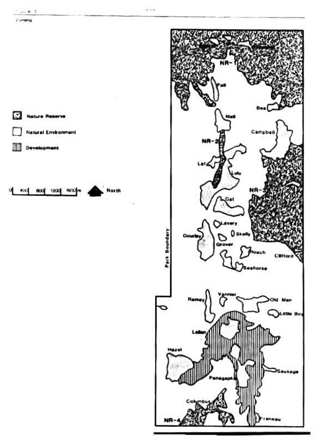
Enlarge figure 3 - Zoning map (PDF)
The old mixed forest complex, the park’s oldest upland forest stand, is the most significant feature in this zone. It is a provincially significant representation of forest fire succession, renowned for its diverse range of site, age, history and successional development including pre- fire relics. Other significant features include jack pine forest and numerous sand dune structures.
A second nature reserve (NR-2) incorporates a 1.4 kilometre long section of the Munro Esker extending from Mall Lake south to Lulu Lake, representing the beaded ridge morphology of the central esker. The 29 hectare reserve provides representation of this 249 kilometre long esker, renowned for its unusual size, construction and probable genetic relationship to underlying bedrock topography. The esker complex is a significant contribution to the provincial nature reserve system given negligible human impact, absence of aggregate mining and the absence of similar features south of the limit of the Late Wisconsin re-advance of continental glaciation within the provincial parks system.
The Campbell Lake nature reserve (NR-3) occupies a 284 hectare area adjacent to and approximately 2.8 kilometres south of Campbell Lake. The boundaries of this zone correspond to the western edge of the east-central bog and parabolic dune complex. These eolian (wind formed) dune complexes are the most valuable earth science feature the park can contribute to the provincial nature reserve system, given the quality of their structure. Although similar dunes are present in other areas of Northern Region, few have been left undisturbed than logging, road construction or recent fire. The zone also contains significant floating bog areas around Little Esker Lake and mature jack pine stands.
The fourth nature reserve (NR-4) includes the 77 hectare regionally significant Columbus Lake Bog. It is situated along the south boundary of the park encompassing those wetland areas along the northern periphery of Columbus Lake. This zone represents a mature peatland habitat, especially notable for its quaking bogs, patterned fen and open bog. The peatland is surrounded by mixed forest as well as jack pine and black spruce and is underlain by a wind-deposited sand dune field.
Nature reserves will be managed for the protection of significant earth and life science features. Park Management will encourage natural evolution of resource features; active management prescriptions will not be undertaken. Areas adjacent to the park are available for commercial forest management.
The park boundary, particularly where nature reserve zones are located, has been identified as an area of concern in the adjacent Iroquois Falls South Timber Management Plan. This plan will incorporate identified forest management practices along the park boundary including harvest, regeneration and access. Development will be limited to trails, portages, necessary signs and minimal interpretive facilities to compliment such compatible recreational activities as hiking, canoeing and nature viewing. Fish stocking is not permitted in nature reserve lakes. Forest extraction and mechanized travel is prohibited. Non-destructive nature interpretation and research is encouraged.
5.2 Natural environment zone
The natural environment zone encompasses much of the park area at 2,105 hectares. This zone protects the natural landscape of Esker Lakes while permitting minimal; development required to support such low- intensity recreational activities as hiking, canoeing, fishing and designated backcountry camping. Additionally, the natural environment zone serves as a buffer between the nature reserves and development zone. Minor tree removal will only be permitted where there is a threat to human safety and property or where it is necessary in order to meet such other park objectives as the provision of recreational trails.
Nineteen lakes are located within this zone including Lulu, Gaf, Lavery, Skelly, Grover, Gourlay, Roach, Pall, Mall, Bea, Seahorse, Vannier, Ramey, Old Man, Little Boy, Sausage, Primeau, Campbell and one unnamed lake. Fish stocking of native species will continue in designated lakes, to satisfy sportfishing demand. With the exception of winter snowmobile use, mechanized travel is prohibited in this zone. Non-destructive nature interpretation and research is encouraged.
5.3 Development zone
This 264 hectare zone encompasses the existing developed area adjacent to Panagapka and Lallan Lakes and the potentially developable area adjacent to Hazel Lake. The Sunny Point campground includes 32 electrically serviced sites and 105 non-electrically serviced sites. Group camping is available for approved groups at two sites. Beach facilities have been developed on Panagapka Lake at Sunny Point Campground and the day use area. Such day use activities as picnicking, swimming and field activities will be confined to designated areas. The park concession and restaurant are located in this zone. Such support facilities as the interpretive building, entrance control booth, park office, staff quarters, Junior Ranger camp, woodyard, maintenance and storage buildings are also located in this zone (Figure 4).
6.0 Resource management policies
The park will be managed in accordance with the general planning and management policies for natural environment class provincial parks (Ontario Provincial Parks Planning and Management Policies 1978). Specific management direction is provided below, to fleet specific resource requirements.
Figure 4 - Park development
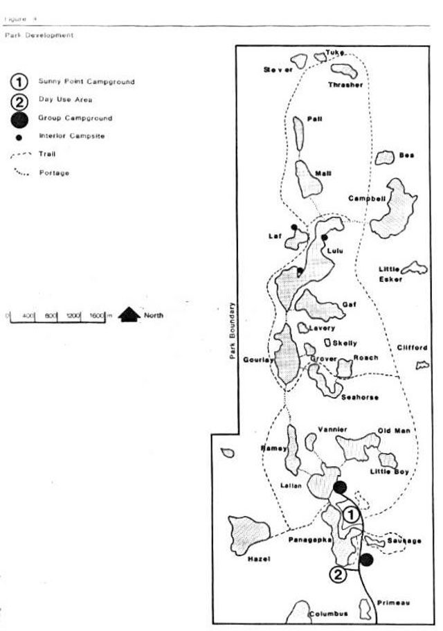
Enlarge figure 4 - Park development map (PDF)
It is important to note that although individual resource policies are described under a series of separate headings, all planning and management will recognize that these components are highly interdependent. An integrated approach to resource management will be required to achieve park objectives.
6.1 Fisheries management
Various lakes within the park provide a popular local sports fishery.
Fisheries management programs undertaken in the park will be consistent with the Kirkland Lake District Fisheries Management Plan (1986) and the Ontario Provincial Park Planning and Management Policies (1978). Fish stocking strategies will continue to provide optimum angler opportunities on a put and take or put and delayed take basis in Natural Environment Zone lakes. Fish stocking is conducted on the basis of individual lake and species requirements. Fish stocking dating to 1954, has been carried out in Gaf, Lallan, Lulu, Mall, Pall, Panagapka, Raney, Roach, Seahorse, Bea and Hazel Lakes. The lakes in the park are primarily managed for cold water species such as lake trout, brook trout, rainbow trout and splake, but cool water (walleye, northern pike) or warm water (smallmouth bass) species may be stocked to satisfy angler demand.
Powerboats are prohibited from all park lakes to ensure water quality in the sensitive kettle lakes and to provide for low- intensity recreational opportunities. Electric boat motors are permitted on Panagapka and Lallan Lakes. These motors do not adversely affect the water quality of these cold water fishery lakes and given their proximity to existing park development, do not represent a noise impact.
Use of live baitfish is prohibited to prevent fish community changes and non-indigenous species introduction. Additional park specific angling regulations may be developed if conditions warrant.
6.2 Vegetation management
Vegetation in the park will be managed to fulfill the protection and recreation objectives of a natural environment class park. The removal of trees will be permitted where a threat to human safety and property exists or where required to meet such park objectives as the provision of recreational opportunities.
Three nature reserve zones have been established in part to protect three regionally and two provincially significant life science communities. Vegetation management in these zones will be directed by the management policies for nature reserves.
Two areas of the park present specific vegetation management concerns. Clear cutting in areas adjacent to the park has exposed boundary stands to windfall in both nature reserves and natural environment zones. In most cases, such windfall sites are located in remote areas, distant from recreational activity areas. Proposed management is to permit windfall to occur and to allow natural aspen and birch succession, creating a wind barrier for remaining conifer stands. Forest extraction in areas adjacent to the park will occur exclusive of the park’s peak operating season of July and August. Modified forest management practices have been incorporated into the adjacent Iroquois Falls South Timber Management Plan.
The development zone requires more intensive vegetation management due to soil compaction, loss of ground cover, overmature jack pine and die -back common to the pure birch stands. Prescriptive silviculture has been employed to improve stand diversity and aesthetics.
Vegetation necessary for slope and soil stability will be maintained and enhanced through hand tending if necessary. Activities found to be causing severe erosion or slope failure will be prohibited or removed to more stable site locations. Rehabilitation work will be undertaken on degraded sites. A Vegetation Management Plan will be prepared in particular to address such noted development zone concerns as tree planting and campsite rehabilitation.
The Ministry of Natural Resources is responsible for fire control and fire equipment is provided in the park to allow park staff to respond to any fire outbreak. Wild fires in all zones will be suppressed.
The existing Sunny Point campground access road serves as a firebreak between the campground and adjacent forest stands. No park facilities will be developed east or north of this road.
Aerial spraying for the release of vegetation is prohibited. Spraying of pathogens/chemicals will not be permitted unless the park is seriously threatened by insects or disease. At such time, spraying will follow guidelines established by the Ministry of Natural Resources and the Ministry of Environment.
Non-native plants will not be introduced into the park. Berry picking and limited personal consumption of edible wild plants other than those found in nature reserves will be permitted.
6.3 Wildlife management
Hunting and trapping are prohibited within the park. Trapping of nuisance animals is permitted for park management purposes only. Non-native wildlife species will not be introduced into the park.
7.0 Operating policies
A Park Operations Plan has been prepared to provide park staff with the information required to operate the park on a day-to-day basis.
In addition to addressing the operations policies, which follow, the plan includes such topics as budget, staffing, maintenance schedules, enforcement and emergency services. The provisions of the strategy will be consistent with the approved Ontario Provincial Parks Operating Standards and will be reviewed annually and updated as required.
7.1 Visitor services
Esker Lakes Provincial Park will provide visitor services at the seasonal level through staff contact and self-use facilities, with emphasis upon the interpretation component, as outlined in the Northern Region Visitor Services Strategy.
The Visitor Services Plan currently being updated will guide the delivery of this program. Utilizing the excellent visitor activity facilities and the beautiful recreational environment of Esker Lakes, visitor services staff will continue to offer varied programming to the main park clientele of family -oriented destination campers. The Visitor Centre houses interpretive exhibits/displays and hosts a variety of visitors services, especially during inclement weather.
7.1.1 Information
Key elements of information conveyed to park visitors will centre upon the natural, cultural and recreational resources of Esker Lakes Provincial Park, with minor focus upon nearby Tbackeray and Pushkin Hills Provincial Nature Reserves. Local tourist attractions and the management policies, facilities and attractions of. The Ontario Provincial Parks system will be highlighted, particularly those parks located in Northern Region.
This information will be conveyed by park staff and will be available at key points throughout the park including the gatehouse and visitor centre. Park brochures will be available for public distribution. Local media will be advised of park programming while park staff will provide extension programs for local communities.
7.1.2 Interpretation
Interpretive programming provides an opportunity to foster a greater appreciation of the natural, cultural and recreational values of Esker Lakes Provincial Park and the local area including nearby Thackeray and Pushkin Hills Provincial Nature Reserves. Major interpretive themes identified for Esker Lakes include local mining camp history, glacial geomorphology, the Northern Transitional Forest and recreational skills development. Interpretation of the provincial nature reserves will focus upon local Precambrian bedrock geology.
Interpretation will be based upon self- use facilities and staff contact. Visitor services staff will conduct nature hikes, recreational skills demonstrations, resource management presentations and other programming.
Self- use facilities include the Prospector’s Trail, Lonesome Bog Trail and Trapper’s Trail. The visitor centre displays various interpretive exhibits. Park staff will provide assistance to groups or individuals utilizing the park for educational purposes.
7.1.3 Recreation
Esker Lakes is particularly well suited to provide a variety of outdoor recreational opportunities including hiking, canoeing, fishing, swimming and nature appreciation. These activities will be emphasized in programs offered to park visitors.
The existing three loops of the Trapper’s Trail will be maintained to accommodate all levels of hiking ability. The Fitness Trail provides an alternative recreational hiking activity. Programs, which develop recreational skills in canoeing, boating safety, overnight hiking and campfire safety will be promoted.
7.2 Marketing
Marketing initiatives are currently developed on an annual basis. Upon completion of a Regional Strategy, a Park Marketing Plan will be developed. Esker Lakes will be promoted in regional and provincial marketing initiatives as a destination campground, offering a full range of facilities and services. Such local tourist attractions as the Museum of Northern History, Englehart and Area Historical Museum, Northern Frontier Zoo du Nord, Hill’s Lake Fish Culture Station, Swastika Forest Station and the Ministry of Northern Development and Mines mineral core library will be highlighted, in an effort to enhance tourism in the Kirkland Lake Area.
7.3 Tourism services
Commercial tourism services within the park consist of a concession/restaurant located in the day use area and canoe/paddle boat rentals on Panagapka Lake. Expansion of existing tourism services is not planned but proposals will be assessed on a case by case basis, consistent with provincial park policies. The park will likely continue to serve as a destination campground. Local area tourist establishments will continue to derive benefit ran these park users.
Figure 5 - Park facilities
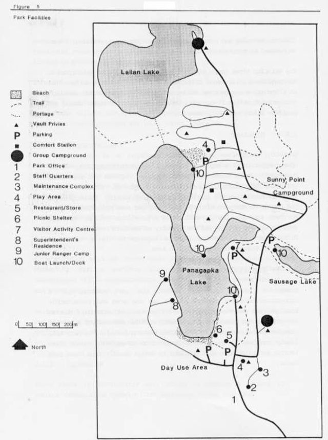
Enlarge figure 5 - Park facilities map (PDF)
7.4 Research
The Ministry of Natural Resources encourages research activities, which increase knowledge and assist in the management of park resources. All research must be approved by the Ministry of Natural Resources and conducted in accordance with the policies guiding research in provincial parks. Research opportunities in Esker Lakes include glacial geomorphology (Munro Esker, kettle lakes, dune complexes), forest ecology, fire succession and local cultural history. A copy of all research reports must be submitted to the Kirkland Lake District office.
8.0 Development policies
This component of the management plan outlines park development in light of current and future recreational needs. Development will proceed in accordance with zone policies established in this management plan, provincial park development standards, approved development plans and the Environmental Assessment Act.
Development focuses upon enhancing many of the existing park facilities including additional vault privies, comfort station, electrically serviced campsites and replacement of the maintenance building. Additional recreational trails and interpretive facilities will be provided. Group camping popularity necessitates upgraded camping facilities. Should park visitation increase appreciably, further park development will be undertaken on Hazel Lake.
Development projects will be implemented as funding permits, according to the outlined “9.0 Implementation Priorities”.
8.1 Camping
8.1.1 Campground
Sunny Point campground has 32 electric and 105 non-electrically serviced sites (Figure 5). As funding permits, ten additional existing sites will be provided with electrical outlets.
Six existing vault privies will be replaced with a small comfort station. If increased visitation warrants additional campground development, it should be undertaken on Hazel Lake to include 20 non-electrically serviced campsites and 2.0 kilometres of internal roads to provide an additional 2,500 camping opportunities. These additional opportunities will assist in achieving recreational targets outlined in the Kirkland Lake District Land Use Guidelines.
8.1.2 Interior sites
Two existing interior campsites on Lulu Lake and the one site on Laf Lake will be maintained for use along the Trapper’s Trail. Utilization of interior sites remains low, additional development is not required.
8.1.3 Group campgrounds
Group campgrounds will be upgraded and landscaped. The group campground at Lallan Lake will be expanded to accommodate increased visitation. Vault privies will be upgraded and expanded.
8.2 Day use area
Day use visitation has remained stable, but has not surpassed optimum use. Further development is not required. Existing developed beach and picnic area will be maintained.
Figure 6 - Proposed development
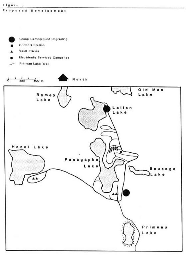
Enlarge figure 6 - Proposed development map (PDF)
8.3 Trails/portages
Use of the various trails and portages have remained popular. All existing trails and portages will be maintained. The “Prospector Trail” focusing on local mining history is currently being completed between the Visitor Centre and the park concession. New trails will be developed to encircle Primeau Lake.
8.4 Administration/operation facilities
A superintendent’s residence has been constructed on Panagapka Lake. The existing residence will be utilized as a park administrative office. Vault privies will be constructed adjacent to the laundromat facility. Dock facilities on Panagapka Lake will be replaced. The maintenance building will be reconstructed.
The former diesel generator building will be remodeled to house interpretive displays for the Prospector’s Trail. Upgrading of exhibits/displays in the Visitor Centre will continue.
9.0 Implementation priorities
The following section provides a prioritized schedule for the implementation of park management policies for resource management, operations and development upon approval of this management plan. Projects will be undertaken subject to availability of funding (Figure 6).
Phase one
Completion of this phase will provide upgraded park facilities.
Priorities
- Reconstruction of the maintenance building.
- Landscaping and upgrading group campgrounds.
- Completion of Prospector’s Trail.
- Filters to be added to existing water system.
- Construction of vault privies adjacent to laundromat/concession area and reconstruction of Panagapka Lake dock.
Phase two
Completion of this phase will provide additional electrically serviced campsites, an improved water system and management direction for life science resources.
Priorities
- Provision of electrical outlets to 10 campsites located along Sunny Point campground “B” road.
- Reconstruction of existing water system to accommodate additional water flow for proposed comfort station and potential development in Phase IV
- Preparation of a Vegetation Management Plan.
Phase three
Completion of this phase will provide additional park services.
Priorities
- Development of Primeau Lake trail.
- Replacement of six Sunny Point campground vault privies with a small comfort station.
Phase four
Completion of this phase will provide 2,500 additional camping opportunities if demand warrants, through development of a Hazel Lake campground.
Priorities
- Preparation of a site and development plan.
- Development of access road and internal circulation road network.
- Development of 20 non-electrically serviced campsites and vault privies.
10.0 Summary of public involvement
Public involvement in the Esker Lakes park management plan was initiated June 1, 1988 with written notices and feature articles in local media. Similar notices were mailed to local individuals and provincial and local interest groups. The 1978 Esker Lakes Provincial Park Master Plan, background reports and resource inventories were available for public review. Few components were received during this initial stage of the planning process.
Public information centres for release of the preliminary park management plan were held August 13-14, 1988 at Esker Lakes and August 15-16, 1988 at the Kirkland Lake District Office in Swastika. Copies of the plan were mailed to interest groups, government agencies and interested parties. All parties were requested to submit by October 9, 1988 comments regarding the preliminary plan to the District Manager in Kirkland Lake. Public comment focused upon future park development priorities and resource management strategies. Park users favoured the maintenance of Esker Lakes as a moderately developed provincial park, with emphasis upon the natural environment setting. Copies of all comments received are available at the Kirkland Lake District Office. The final park management plan incorporates comments received during public consultation stages of the planning process and was released for final public comment in April 1989.
This management plan will be reviewed at least once every 10 years to re-confirm all resource management, operations and development policies. Minor amendments may be made in the interim as required.
Major amendments having broad implications for park management will include public involvement.
11.0 References
Frey, E. 1977 Inventory and Assessment of Earth Science Features in Esker Lakes Provincial Park. Environmental Planning Series. Parks and Recreational Areas Branch, Ontario Ministry of Natural Resources, Toronto.
Hills, G. A. 1959 A Ready Reference to the Description of the Land of Ontario and It’s Productivity. Ontario Ministry of Natural Resources, Toronto.
Macdonald, I.D. 1978 Parks Systems Life Science Analysis - Preliminary Report. Northern Region, Division of Parks, Ontario Ministry of Natural Resources, Cochrane.
Noble, T. 1981 Esker Lakes Provincial Park - Life Science Inventory. Parks and Recreational Areas Branch, Ontario Ministry of Natural Resources, Toronto.
Ontario Ministry of Natural Resources 1978 Ontario Provincial Parks Planning and Management Policies. Parks and Recreational Areas Branch, Toronto.
Ontario Ministry of Natural Resources 1978 Esker Lakes Provincial Park Master Plan. Kirkland Lake District, Swastika.
Ontario Ministry of Natural Resources 1983 Kirkland Lake District Land Use Guidelines. Swastika.
Ontario Ministry of Natural Resources 1986 Kirkland Lake District Fisheries Management Plan. Swastika.
Ontario Ministry of Natural Resources 1987 Northern Region Visitor Services Strategy. Cochrane
Ontario Ministry of Natural Resources 1988 Thackeray Provincial Nature Reserve Management Plan. Kirkland Lake District, Swastika.
Ontario Ministry of Natural Resources 1988 Pushkin Hills Provincial Nature Reserve Management Plan. Kirkland Lake District, Swastika.
Ontario Ministry of Natural Resources 1989 Timber Management Plan 1989-1999, Iroquois Falls South Timber Management Unit. Kirkland Lake District, Swastika.
Perraton, D. 1975 Inventory and Assessment of Life Science Features in Esker Lakes Provincial Park. Environmental Planning Series, Parks and Recreational Areas Branch, Ontario Ministry of Natural Resources, Toronto.
Pollock, J. 1974 The Cultural History of Kirkland Lake District, Northeastern Ontario. M.A. Thesis, McMaster University, Hamilton.