Garden River Forest Conservation Reserve Management Statement
This document provides policy direction for the protection, development and management of the Garden River Forest Conservation Reserve and its resources.
Statement of Conservation Interest
Ministry of Natural Resources
Sault Ste. Marie District
Algoma Area
February 2004
Ce document est seulement disponsible en anglais.
Approval statement
I am pleased to approve this Statement of Conservation Interest (SCI) for Garden River Forest Conservation Reserve (C263).
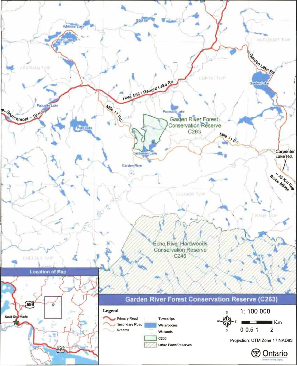
Garden River Forest Conservation Reserve was established to protect balsam fir and yellow birch mixed forests growing on glacial deposits in low hilly terrain. Scattered oldgrowth white pine, as well as white spruce and sugar maple, are additional components of the Garden River forest. Garden River flows through the conservation reserve providing approximately 4 kilometers of riparian conditions within the protected area. Regulated on December 21, 2000, this 299 hectare conservation reserve is situated in Curtis Township, approximately 5O kilometers north of the Town of Bruce Mines and 25 kilometers east of the community of Searchmont.
Direction for establishing, planning and managing conservation reserves is defined under the Public Lands Act, the Ontario’s Living Legacy Land Use Strategy, and other applicable policies. The specific direction for managing this conservation reserve is in the form of a Statement of Conservation Interest, which defines the area to which the plan applies, provides the purpose for which the conservation reserve has been proposed, and outlines the Ministry of Natural Resources' management intent for the protected area. This SCI will provide both the foundation for the continued monitoring of activities and guidance for the management of the conservation reserve. More detailed direction at this time is not anticipated. However, should significant facility development be considered or complex issues arise requiring additional studies, more detailed management direction in the form of special protection measures, or a detailed Resource Management Plan, will be prepared with full public consultation.
Public and Aboriginal consultation occurred prior to the regulation of this conservation reserve. An additional 15-day consultation period took place in December 2003 that provided stakeholders with an opportunity to comment on the draft SCI. Comments from the review period have been considered in the completion of this document.
The management guidelines outlined in this SCI will be implemented by the Algoma Area Supervisor, and will be reviewed every five years and amended as required by the District Planner, Sault Ste. Marie District, Ministry of Natural Resources.
Written by:
Sheila Walsh
OLL Planner
Date: January 26, 2004
Submitted by:
Erin Nixon
District Planner
Date: February 5, 2004
Recommended For Approval by:
Ron Reffle
Algoma Area Supervisor
Date: February 24, 2004
Recommended For Approval by:
Serge Tenaglia R.P.F.
District Manager, Sault Ste. Marie
Date: February 24, 2004
Approved by:
Rob Galloway
Regional Director, Northeast Region
Date: April 2, 2004
1.0 Introduction
The following document is a Statement of Conservation Interest (SCI) for Garden River Forest Conservation Reserve (C263). The purpose of this SCI is to identify and describe the natural, recreational, and cultural values of Garden River Forest Conservation Reserve, and to outline the Ministry of Natural Resources' management intent for this area. The first three sections of this document highlight the provincial context in which it was produced, state its goal and objectives, and summarize the planning process for conservation reserves. Sections 4 through 7 are specific to Garden River Forest Conservation Reserve and provide background information and management direction for the site. Section 8 outlines the requirements for continued implementation and review of this document.
Management direction specified in this SCI will serve to protect the conservation reserve for the benefit of all Ontario residents. This direction will comply with the land use intent stated in the Ontario’s Living Legacy Land Use Strategy (LUS) (OMNR 1999) and associated policy clarification statements. Additionally, this conservation reserve will be managed under the Public Lands Act (OMNR 1997a), and will comply with all legal requirements as specified under the Environmental Assessment Act (RSO 1990, Chapter E.18).
1.1 Provincial context
Ontario’s network of natural heritage areas has been established to protect and conserve areas representative of the diversity of the natural regions of the province, including the species, habitats, features, and ecological systems which comprise that natural diversity. Protected natural heritage areas are a key component in the sustainable management of natural resources. They ensure that representative sites within the larger managed landscape are retained in as natural a state as possible.
On July 16, 1999, the Ontario’s Living Legacy Land Use Strategy was released to guide the planning and management of much of Ontario’s Crown lands. Extensive consultation was conducted during the development of the LUS. The objectives of the LUS are to complete Ontario’s system of parks and protected areas; recognize the land use needs of the resource-based tourism industry; provide forestry, mining and other resource industries with greater certainty around land and resource use; and, enhance hunting, angling and other Crown land recreational opportunities (OMNR 1999).
The LUS (OMNR 1999) contributes to Ontario’s system of protected natural heritage areas by designating 378 new areas to be protected. These areas are considered to be significant and require protection from incompatible activities in order for their values to endure over time. Garden River Forest Conservation Reserve now forms part of Ontario’s network of natural heritage areas. It protects yellow birch (Betula alleghaniensis Britton) and balsam fir (Abies balsamea L.) dominated forest stands growing on glacial deposits in low, hilly terrain. The site also protects old-growth white pine (Pinus strobus L.) and small areas of medium-aged white spruce (Picea glauca (Moench) Voss) and sugar maple (Acer saccharum Marshall). Approximately four kilometers of riparian communities along the Garden River are also protected.
The Ministry of Natural Resources has established conservation reserves as a tool to protect natural heritage areas on public lands, while permitting most traditional public land uses to continue. These uses include recreational activities, such as hunting and fishing, and the traditional activities of Aboriginal communities, as defined under applicable Aboriginal treaties. Lands designated as conservation reserves in the LUS (OMNR 1999) are removed from the Sustainable Forest License area, and mining and surface rights are withdrawn from staking under the Mining Act (RSO 1990 Chapter M.14).
The LUS (OMNR 1999) and subsequent policy clarification statements outline the general land use policy and management direction for new conservation reserves. Each new conservation reserve will have a planning document, either a SCI or, in more complex situations, a Resource Management Plan, that details site-specific management direction.
2.0 Goal and objectives of the SCI
2.1 Goal
The goal of this SCI is to provide the framework and the direction to guide management decisions affecting Garden River Forest Conservation Reserve.
2.2 Objectives
The following objectives are identified as the means to achieve the above stated goal:
- To describe the site’s current state of the resource in terms of its values and existing uses and activities
- To outline the Ministry of Natural Resources' management intent for the protected area
- To determine the land use compatibility of current land uses, and to develop specific guidelines and prescriptions to manage these uses
- To create public awareness of the values within this conservation reserve by providing information on the resources it contains and protects, and to support responsible stewardship through partnerships with local stakeholders
- To identify research, client services, and/or marketing strategies that may contribute to sound long-term management of the conservation reserve
- To identify the monitoring and/or research necessary to maintain the integrity of protected values
- To provide direction for the evaluation of proposed new uses or economic ventures through the application of the Test of Compatibility (Appendix C) and applicable Environmental Assessment Act legislation. This test will evaluate the impact of suggested use(s), either positive or negative, on the protected values of the conservation reserve
3.0 Management planning
3.1 Planning for a Conservation Reserve
The planning process for a conservation reserve consists of regulating the site and preparing a site specific management plan. Consultation with the public, Aboriginal communities, and industry occur during site identification, boundary finalization, and management planning. Regulation of a conservation reserve involves preparing a legal description of site boundaries, removing the site from the Sustainable Forest License area, and withdrawing the site from staking under the Mining Act (RSO 1990 Chapter M.14). Once a conservation reserve is regulated, the level of management planning required to fulfill the protection targets is determined, and either a basic or enhanced SCI or a Resource Management Plan is prepared.
A basic SCI is prepared when there is no deviation from the land use direction provided in the LUS (OMNR 1999) and there are few to no issues that require resolution. Alternatively, a Resource Management Plan (RMP) is prepared in situations where one or more complex issues have to be addressed, or where there is widespread public interest in a site. An enhanced SCI is an intermediary document which is used when a site requires more detailed management direction than would be provided by a basic SCI, but does not have issues significant enough to warrant the preparation of a RMP. Whichever the determination, the plan must be completed within three years of the conservation reserve’s regulation date. The guidelines for the preparation of these documents are provided in Procedural Guidelines A - Resource Management Planning (Conservation Reserves Procedure PL3.03.05, Public Lands Act) and the Northeastern Region Guidelines on the Planning Process for Conservation Reserves: Statement of Conservation Interest and Resource Management Plan (Thompson 2001).
A SCI is essentially a management plan, which receives its direction from the LUS (OMNR 1999). The purpose of a SCI is to identify the state of the resource in terms of the site’s values and its current land use activities, and to outline the Ministry of Natural Resources' management intent for the conservation reserve. Basic SCIs typically have a 15-day public consultation period, whereas enhanced SCis and RMPs have a longer consultation period. Upon completion of this public review, the SCI, or RMP, is revised as necessary and approved by the appropriate Regional Director.
Existing permitted uses within conservation reserves may continue, unless they are shown to have a significant negative impact on the values protected by the site. A review/evaluation mechanism is in place to address proposed new permitted uses or land use proposals. The Test of Compatibility (Appendix C) as outlined in the Public Lands Act Policy PL 3.03.05 (OMNR 1997a), and/or other standard Ministry of Natural Resources environmental screening processes, are used to screen future proposals. Where cultural resources may be impacted, proposals may be screened through Conserving a Future for our Past: Archaeology, Land Use Planning & Development in Ontario, Section 3 (Ministry of Culture 1998).
Public comment may be solicited during a review of any future land use proposals that require new decisions to be made. Appropriate Environmental Assessment Act (RSO 1990, Chapter E.18) requirements and amendment processes will apply to any future proposal and/or any significant change in management direction being considered for a site.
3.2 Planning Process for Garden River Forest Conservation
Reserve
Garden River Forest Conservation Reserve was proposed as a conservation reserve in the LUS (OMNR 1999). Consultation has occurred with the public, Aboriginal communities, and industry, and the boundary of the site has been regulated through an amendment to Ontario Regulation 805/94 of the Public Lands Act on December 21, 2000, by Ontario Regulation 686/00. A copy of public consultation information can be found in Appendix E.
To date, no significant issues related to land use in this area have been identified. For this reason, it was determined that a basic SCI will adequately identify the site’s significant features and will serve as an appropriate format for delivering the management guidelines. It should be noted that this document addresses only those issues or land use proposals currently known to the District Manager. The direction provided by this SCI, and future management decisions, will work to resolve any potential land use conflicts and to ensure that identified values continue to be adequately protected.
3.2.1 Planning area
The planning area for this SCI consists solely of the regulated boundary for Garden River Forest Conservation Reserve (Figure 1). However, to fully protect values within the conservation reserve, the area beyond the regulated boundary may require additional consideration when larger land use planning initiatives pose potential negative impacts on the conservation reserve. The forest management planning process is an example of when adjacent land management activities may consider sensitive features within the conservation reserve boundary.
4.0 Background information
4.1 Location and site description
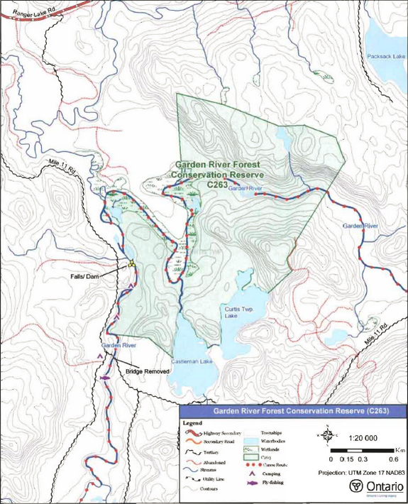
Garden River Forest Conservation Reserve is located in Curtis Township, approximately 50 kilometers north of the Town of Bruce Mines and 25 kilometers east of the community of Searchmont (Figure 1). This site was regulated on December 21, 2000 and is 299 hectares in size. Table 1 summarizes the administrative details of the site.
Whenever possible, recognizable natural and cultural features, such as creeks, shorelines or old roads, have been used to delineate conservation reserve boundaries to facilitate on-the-ground identification. The western and southern boundaries of Garden River Forest Conservation Reserve follow natural features: the west boundary is defined by the east shore of the Garden River, and the south boundary, in part, follows the northern shores of Castleman Lake and Curtis Township Lake #3 (locally known as Strums Lake). Vectored boundaries (straight lines connecting two points) have been used to define most of the remaining boundaries (east and northeast sides) because there were few suitable natural or cultural features in these areas (see Map 1, Appendix A).
Garden River Forest Conservation Reserve can be approached via the Mile 11 Road, south off of the Ranger Lake Road (Figure 1). Mile 11 Road once connected Ranger Lake Road and Carpenter Lake Road, southeast of the conservation reserve. However, in 2001, the bridge crossing the Garden River on Mile 11Road was removed, thereby disconnecting the two roads. While the west arm of the Mile 11 Road continues to be used to gain access to the Garden River, it is no longer maintained. In this area, the east shore of the Garden River forms part of the boundary of the conservation reserve. Access into the conservation reserve from this location requires crossing the river.
Access to the conservation reserve may also be possible from Carpenter Lake Road, via the east arm of Mile 11 Road. Although not confirmed, it is probable that this stretch of the Mile 11 Road has deteriorated and may only be navigable by all-terrain vehicle (ATV).
A network of old logging roads, south of the Ranger Lake Road, approaches the northwest corner of the conservation reserve. Through access on these roads is also expected to be limited due to the removal of water crossings following the cessation of forestry operations.
Table 1. Location and administrative details for Garden River Forest Conservation Reserve.
| Name | Garden River Forest Conservation Reserve (C263) |
|---|---|
| Site Region -Site District (Hills 1959) | 4E-3 Missisagi |
| Eco Region -Eco District (Crins and Uhlig 2000) | 4E-3 |
| OMNR Administrative Region/District/Area | Northeast Region/Sault Ste. Marie District/Algoma Area |
| UTM co-ordinates | 285900 E, 5179231 N (Zone 17 NAD 83) |
| SCI Completed | January 26, 2004 |
| Regulated | December 21, 2000 |
| Area | 299 ha |
| Nearest Town | Approximately 50 km north of the Town of Bruce Mines; approximately 25 km east of the community of Searchmont |
| Township(s) | Curtis |
| OBM Numbers | 2017280051800, 2017280051700 |
| Topographical Map Number / Name | 41 J/12 Echo Lake |
| Wildlife Management Unit | 36 |
| Forest Management Unit | Algoma Forest |
Garden River Forest Conservation Reserve is located within Hills' Site District 4E-3 (Hills 1959), an ecological unit extending roughly from Gogama and Chapleau in the north to Sudbury and Elliot Lake in the south. The conservation reserve is typical of conditions in the site district as it consists of mixed hardwood-dominated forests on rolling, rugged topography. Garden River Forest is not high in diversity; it is a relatively small site with only two main landform conditions (Kristjansson 2003) and a limited variety of forest stand types (Burkhardt et. al. 2003). The Garden River flows through the northern portion of the conservation reserve and forms part of its western boundary. The riparian zone associated with this river contributes to the site’s overall diversity. A headwater pond and tributary stream situated in the north part of the conservation reserve feed the Garden River. Steep-sided slopes on both sides of the river in the north part of the conservation reserve, and the forest communities therein, provide recharge functions for the river. Photos of the conservation reserve can be found in Appendix B.
Figure 1. Location of Garden River Forest Conservation Reserve.
4.2 History of the site
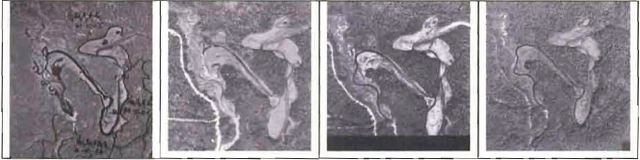
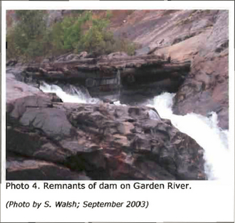
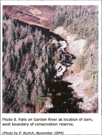
Logging has played an important role in the area surrounding Garden River Forest Conservation Reserve, although most of the stands within the conservation reserve appear to have been unaffected by logging activities, at least within recent history. Historical activities along the Garden River are of interest, particularly along the stretch where the river forms the conservation reserve’s western boundary. A dam on this stretch of the Garden River was constructed to facilitate log drives on the river. The dam was located at the top of a waterfall through a natural gorge where the river is only a few meters wide. Bedrock on both sides of the river at this location plunges steeply into the water (Figure 2). The dam structure is still visible in the river (Figure 3). With the dam in place, water levels upstream were subject to variation thus contributing to the development of river features such as oxbows and point bar forms (Kristjansson 2003). Over time, these features have become less pronounced, and increasingly vegetated (Figure 4), suggesting that water levels are more stable now that the dam is no longer used to control flows.
Figure 2: Dam location on Garden River, looking eastward over conservation reserve.
(September 2002; Photo by T. Latulippe)
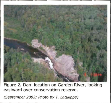
Figure 3: Remnants of Garden River dam.
(September 2003; photo by S. Walsh)
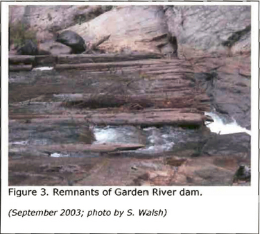
Figure 4: Aerial photos showing Garden River above the dam in (left to right) 1964, 1973, 1981, 1994.
4.3 Inventories
Below, in Table 2, the current status of natural heritage inventories is summarized for Garden River Forest Conservation Reserve. Recommendations for future inventory needs are located in Table 3, Section 7.2.
Table 2: Existing inventory and survey information for Garden River Forest Conservation Reserve.
| Type of Inventory | Inventory Method | Date(s) of Inventory | Report |
|---|---|---|---|
| Life Science | Aerial reconnaissance | 9 Sept. 2002 | Burkhardt, B., L. King, and S. Longyear, 2003. Garden RiverForest Conservation Reserve, Life Science Checksheet - Step 2. Unpublished Information. Ontario Ministrv of Natural Resources. |
| Earth Science | Aerial reconnaissance | 9 Sept. 2002 | Kristjansson, FJ., 2003. Earth Science Science Inventory Checklist for Garden River Forest Conservation Reserve. Unpublished Information. Ontario Ministry of Natural Resources. |
| Recreation | Ground and aerial reconnaissance | Ground: 22 Sept. 2003 Aerial: 9 Sept. 2002 |
Latulippe, T. and M. Hall, 2003. Recreation Inventory Report – Garden River Forest Conservation Reserve (C263). Unpublished Information. Ontario Ministry of Natural Resources. |
5.0 State of the resource
5.1 Key values
Key values are those values that make this site unique and have led to its designation as a conservation reserve. Their protection is paramount. The key values found within Garden River Forest Conservation Reserve include the following:
- Riparian communities associated with the Garden River
- Fishing opportunities within the Garden River
- Yellow birch and balsam fir dominated stands on weakly broken valley train deposits (*This vegetation/landform combination led to the area’s designation as a conservation reserve; the yellow birch and balsam fir stands are represented but the landform was not adequately captured in the conservation reserve boundary. See Section 5.2 and Section 7.1 for additional information)
Additional values as listed in Section 5.2 through Section 5.6 are also important. Descriptions in this section are not necessarily complete. If new values, key or otherwise, are identified, they will be added to this section. If any new value is considered significant, management guidelines may be modified, if required, to ensure its protection.
5.2 Earth sciences values
Garden River Forest Conservation Reserve is located in a broad geologic area known as the Abitibi Uplands, which is characterized by an undulating, rocky landscape of uplands and valleys with an abundance of lakes, folds and faults. The Abitibi Uplands are largely underlain by gneiss and granitic rocks. This bedrock geology is covered generally by stony sandy tills with frequent flats and ridges of water-laid sand (Crins 1996).
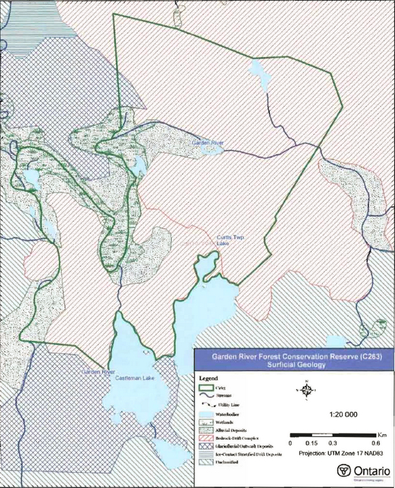
Within the conservation reserve, the topography varies from relatively flat lowlands along stretches of the river to steep and rugged hills. According to Kristjansson (2003), the site is immediately underlain by four main deposit features: bedrock-drift complex; ice-contact stratified drift deposits; glaciofluvial outwash deposits; and alluvial deposits (see Map 2, Appendix A). The bedrock-drift complex dominates the site’s surficial geology. Most of the northern half and part of the southern half of the conservation reserve is immediately underlain by an extensive area of bedrock-drift complex. In the northern portion, the area is rugged and is characterized by high local relief. Moderate to steep bedrock slopes, including a bedrock cliff with substantial talus accumulation at its base (Figure 5), are associated with the Garden River in the northern half of the conservation reserve. The bedrock-drift complex in the southern half of the conservation reserve is also rugged, but local relief here is best described as moderate and topography is described as gently rolling.
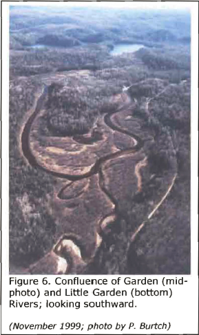
Lowland features occupy the remainder of the conservation reserve (Kristjansson 2003). These include ice-contact stratified drift deposits, glaciofluvial outwash deposits, and alluvial deposits from both recent and glacial activities. The alluvial deposits associated with the Garden River are especially noteworthy. Well-defined alluvial terrace remnants are situated immediately adjacent to or in the vicinity of the Garden River. In addition, well-developed point bar forms, with obvious scroll bar development directly related to the meandering style of the Garden River, add considerably to the interpretive value of this conservation reserve (Figure 6).
Kristjansson (2003) describes in more detail the bedrock and surficial geology of the site in the Earth Science Inventory Checklist. According to Burkhardt et. al. (2003), this conservation reserve does not adequately capture the earth science feature that contributed to Crins' (1996) provincially significant designation. Kristjansson’s (2003) interpretation of aerial photographs for the site indicated that the significant "weakly broken valley train" features are located outside of the regulated boundary, along the Garden and Little Garden Rivers, north and south of the site.
Figure 5: Bedrock cliff with talus accumulation.
(September 2002; photo by T. Latulippe)
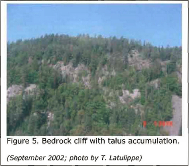
Figure 6: Confluence of Garden (mid-photo) and Little Garden (bottom) Rivers; looking southward. (November 1999; photo by P. Burtch)
5.3 Life Sciences Values
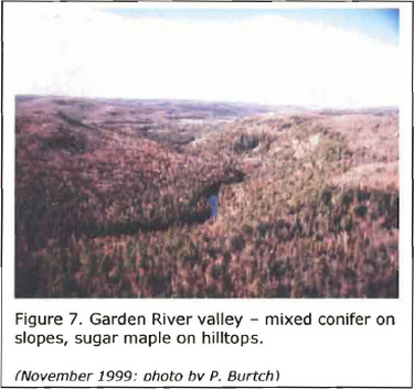
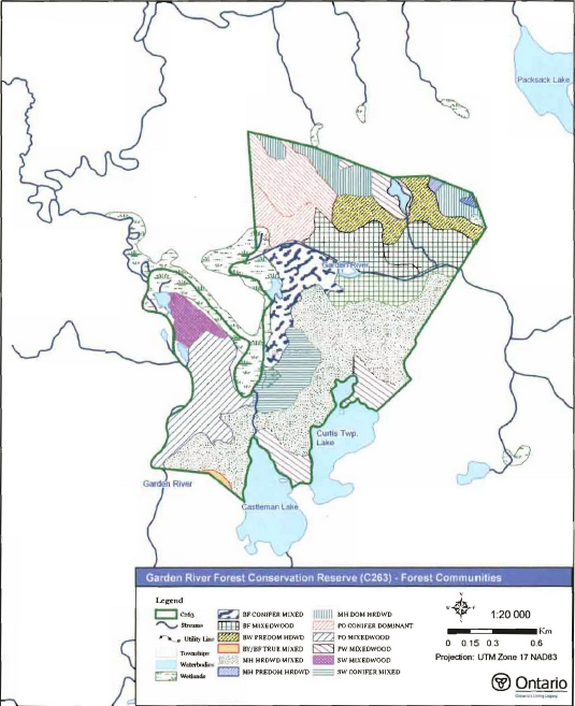
The forest communities in Garden River Forest Conservation Reserve consist primarily of sugar maple and balsam fir mixed stands with some white pine, poplar (Populus tremuloides Michx.) and white spruce stands (see Map 3, Appendix A). The most dominant forest community is sugar maple mixedwood that is associated with the upper reaches of the rugged hills found throughout the site. Balsam fir and red maple (Acer rubrum L.) dominated mixedwoods are also associated with the rugged hills, particularly the steep slopes bordering the Garden River (Figure 7). Sugar maple dominated mixed stands have developed on gentler slopes in the site, while white pine dominated stands tend to be located adjacent to the site’s lakes. Where topography is flatter around the Garden River in the western portion of the conservation reserve, forest communities consist of trembling aspen and white spruce dominated mixedwoods.
Stocking in stands within the conservation reserve ranges from 50 to 100% (Burkhardt et. al. 2003). The northern half of the conservation reserve tends to have well-stocked stands, typically in the range of 70-80%. Some sugar maple and white birch stands on ridge tops north of the Garden River are reported to be fully stocked (100%). A mixed sugar maple stand near the two lakes in the southern half of the conservation reserve, has also been identified as 100% stocked. Compared to other stands, stocking in the white spruce mixed stands in the western portions of the conservation reserve is lower (50-60%); this may be due to the stands' proximity to the Garden River’s floodplain (Burkhardt et. al. 2003).
Although diversity in tree species composition is limited, forest stands within this conservation reserve demonstrate a high diversity of ages, ranging from about 30 to 140 years (Burkhardt et. al. 2003). The youngest stands are situated on the north shore of the Garden River, where selective harvesting took place in the 1960s and 1970s. The oldest stands (approximately 120 to 150 years) contain white pine and sugar maple and are located south of the Garden River, mid-site, as well as surrounding Castleman Lake. These stands, along with balsam fir and red maple dominated mixedwood stands, have been identified as possible old-growth stands (Burkhardt et. al., 2003).
Wetland features within the conservation reserve are not abundant, although the riparian/floodplain zone along the Garden River contributes small patches of marsh and shore fen. Only minor amounts of sedges and floating vegetation have established along the shorelines of the lakes in and adjacent to this conservation reserve.
The conservation reserve has several important fish and wildlife values. The Garden River’s gravel and cobble substrate provides ideal spawning habitat for a number of fish species including brook trout (Salvelinus fontinalis), rainbow trout (Oncorhynchus mykiss) and salmon (Oncorhynchus spp.). During an inventory flight over the site in September 2002, salmon were observed in abundance near these spawning beds. In addition to the river’s fish populations, Castleman Lake and Curtis Township Lake #3, although outside the conservation reserve boundary, are known to contain brook trout, as well as a number of baitfish species. Curtis Township Lake #3 was stocked with brook trout up to 1985.
Burkhardt et. al. (2003) identified the western portion of the site where the Little Garden River flows into the Garden River as a moose aquatic feeding area and a moose wintering area. Bald eagles (Haliaeetus leucocephalus) have been observed in flight over the conservation reserve but there has been no confirmation of breeding within the site’s boundaries. Wood turtles (Clemmys insculpta), which are classified by the Committee on the Status of Endangered Wildlife as "Species of Special Concern", have been observed in the vicinity of the conservation reserve. It is possible that wood turtles inhabit some parts of the site, though this has not been confirmed. The wood turtle has characteristics that make it particularly sensitive to human activities and natural disturbances.
Other values identified in Garden River Forest Conservation Reserve include portions of two bear management areas and part of a registered trapline.
Figure 7: Grand River valley – mixed conifer on slopes, sugar maple on hilltops. (November 1999; Photo bv P. Burtch)
5.4 Recreational Values
Garden River Forest Conservation Reserve currently supports a variety of recreational pursuits, and offers potential opportunities for a number of others. Several recreational features have been identified (Latulippe and Hall 2003), including: the Garden River and its associated falls and riparian zone; rolling to steep hills; a variety of mixed forest stand types; an abundance of popular sport fish in the Garden River and adjacent lakes; and bald eagles, as well as other bird and wildlife species.
Fishing is the most common existing recreational activity, although the greatest concentration of fishing activity takes place in the Garden River where it is adjacent to the conservation reserve’s western boundary (Figure 8 . Fly-fishing is particulary popular in the Garden River, as demonstrated byfishermen crowding the waterway during the fall migration of salmon. The river is a popular fly fishing destination at other times of the year as well. Although the lands west of the river are excluded from the regulated boundary, it is important to recognize the recreational uses that exist adjacent to the conservation reserve. These include numerous campsites and shoreline trails that have been developed over the years by fishermen (Figure 9). Hunting is also recognized as an existing activity within the site.
Canoe-tripping on the Garden River is a less common activity, although the river is part of a recognized canoe route. Portage trails around falls and rapids, as well as into adjacent lakes, are reported to exist although they are not formally documented or maintained. Other existing, but less formal recreational pursuits include hiking, nature appreciation, bird and wildlife observation, and picnicking. Additional activities might include river kayaking or climbing on the steep slopes and rugged topography.
Recreational use tends to increase with the availability of motor vehicle access to a site. Although the conservation reserve is surrounded by roads, there are no known trails into the interior of the conservation reserve. As well, the most direct access to the area around the conservation reserve, the Mile 11 Road, has been limited by the removal of the bridge across the Garden River. Access to the site from the east side is uncertain and is likely restricted to all-terrain vehicles. The use of watercraft to cross the Garden River appears to be essential for accessing this conservation reserve.
A more detailed analysis of the recreational values associated with Garden River Forest Conservation Reserve is presented in Recreational Inventory Report for Garden River Forest Conservation Reserve (Latulippe and Hall 2003).
Figure 8: Fishing for salmon in Garden River, west side of conservation reserve (September 2003; Photo by S. Walsh)
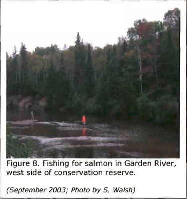
Figure 9: Campsite on west shore of Garden River, outside of conservation reserve. (September 2003; Photo by S. Walsh)
5.5 Cultural values
This site falls within the Robinson-Huron Treaty area. To date, no First Nation community has identified any specific Aboriginal values within this conservation reserve.
5.6 Research values
There are no known research and/or monitoring activities occurring within this conservation reserve.
5.7 Site condition
The area within the regulated boundary of this conservation reserve is described as pristine (Burkhardt et. al. 2003), because it is estimated that less than 1% of the site has been disturbed by human or natural activities in recent years. Human activities within the conservation reserve (ie. possibly short portage trails around difficult stretches of river) have had minimal effect. Incidents of natural disturbance within the site include the sloughing of bedrock into an accumulation of talus on the north side of the Garden River, and seasonal flooding at the three sharp bends in the Garden River at the northwest corner of the conservation reserve (Burkhardt et. al. 2003). Human disturbance, in the form of roads and forest harvest operations, is evident and widespread beyond the regulated boundary of the site.
6.0 Management guidelines
All management guidelines in this SCI are based on direction contained in the LUS (OMNR 1999) and associated policy clarification statements. The management guidelines outlined in this section are specific to Garden River Forest Conservation Reserve and are intended to protect the site’s unique values. The guidelines in this document may be subject to change and may be amended as necessary. If a conflict between management guidelines exists, the conservation reserve will be managed to protect the integrity of its natural values, while permitting compatible land use activities (Public Lands Act, PL 3.03.05).
Proposed new uses and/or development, as well as research and education activities, will be reviewed on a case-by-case basis. Before new proposals can be permitted, the Test of Compatibility (Appendix C) must be passed as well as consideration of cultural values according to Conserving a Future for our Past: Archaeology, Land Use Planning & Development in Ontario, Section 3 (Ministry of Culture 1998). In addition, all new proposals are subject to applicable Environmental Assessment Act (RSO 1990, Chapter E.18) requirements.
The following management strategies have been devised to achieve the goal and objectives of the SCI for Garden River Forest Conservation Reserve. A summary table of the management guidelines for this site can be found in Appendix D. For the most up-to-date version of this summary table, please refer to the Crown Land Use Atlas, located on the Internet at Crown Land Use Policy Atlas, or contact the local Ministry of Natural Resources office. The Crown Land Use Atlas is a consolidation of existing local land use policies for Crown lands within the OLL planning area, an area that covers 45% of the province, extending from Lake Simcoe in the south to the Albany River in the north.
6.1 Industrial activities
6.1.1 Commercial timber harvest
The area contained within this conservation reserve (299 ha) has been withdrawn from the Algoma Sustainable Forest License area and no commercial timber harvesting will be permitted. Please refer to Section 6.4.3 for information regarding non-commercial wood harvesting.
6.1.2 Mining and exploration
There are no existing mining claims or leases within this conservation reserve. Mining and surface rights within the conservation reserve’s boundaries have been withdrawn from staking under the Mining Act (RSO 1990 Chapter M.14). Mineral exploration is not permitted,
6.1.3 Extraction of peat, soil, aggregate and other material
Extraction of peat, soil, aggregate and other material is not permitted.
6.1.4 Energy generation
Hydropower development and windpower generation are not permitted.
6.2 Existing and proposed development
6.2.1 Transportation corridors
6.2.1.1 Roads
According to the LUS (OMNR 1999), new roads for resource extraction will not be permitted except for those identified in Forest Management Plans prior to March 31, 1999. No new or existing roads for resource extraction were identified.
6.2.1.2 Trails
Currently, no major organized winter or summer trails have been identified.
Any proposed new trails will be subject to the Test of Compatibility (Appendix C) and applicable Ministry of Natural Resources policies and procedures. Trail development in low-lying areas and wetlands will be discouraged, as will trail development over shallow soils on rock outcrops. All new and existing trail heads and trail routes must be recorded using new technologies (ie. global positioning systems) to ensure an accurate record of the location of the feature. This location information must be provided to the Sault Ste. Marie District, Ministry of Natural Resources.
6.2.2 Other corridor development/Maintenance
No communication, energy transmission, or other non-road corridors are located within this conservation reserve. New corridor developments will be actively discouraged. Proposals for new corridors will be subject to the Test of Compatibility (Appendix C) and applicable Ministry of Natural Resources policies and procedures.
6.2.3 Natural heritage appreciation facilities/Recreational structures
There are currently no existing authorized natural heritage appreciation facilities or recreational structures (ie. boardwalks, bird viewing platforms, kiosks, ski shelters, or interpretative signs). New natural heritage appreciation facilities and recreation structures are permitted, subject to the Test of Compatibility (Appendix C) and applicable Ministry of Natural Resources policies and procedures. No such structures are being considered at this time.
6.2.4 Land Disposition
Sale of Crown lands is not permitted, except for those situations described in the policy clarification tables (OMNR 2000).
Presently, no Land Use Permits (LUPs) have been issued within this conservation reserve for private or commercial recreational facilities. New leases or LUPs may be issued for approved public uses (ie. not for private recreation camps), subject to the Test of Compatibility (Appendix C) and applicable Ministry of Natural Resources policies and procedures. These leases/permits will not be sold but may be eligible for enhanced tenure or transfer.
Enhanced tenure is defined as anything beyond the term and form of current tenure. All requests for transfer or enhanced tenure will be subject to the following screening criteria:
- Is the transfer or enhanced tenure consistent with the conservation reserve’s land use intent, which is the protection and enhancement of the site’s natural, recreational and cultural values?
- Is it consistent with the land disposition policies outlined in the District Land Use Guidelines, the Crown Land Use Atlas, this SCI and any other applicable document?
- Does it adversely affect the values as identified in Section 5.0, and/or conflict with other uses?
- Is land needed by the Crown to protect significant natural or recreational values outlined in this SCI?
- Does the transfer or enhanced tenure clash with traditional Aboriginal uses, land claims or agreements?
- Are all rents, taxes, fees, rates or charges paid up for the existing LUP or lease?
6.3 Commercial activities
6.3.1 Commercial bait harvesting
Curtis Township is currently allocated to one commercial bait harvesting operation. New operations can be considered subject to the Test of Compatibility (Appendix C) and applicable Ministry of Natural Resources policies and procedures.
Under Public Lands Act PL 3.03.08 "Buildings for Bait Harvesting Management" (OMNR 2002), cabins for the purposes of bait harvesting may be constructed on Crown land. However, such buildings should be avoided within this conservation reserve wherever possible and be established on Crown land outside of the protected area.
6.3.2 Commercial fishing
There are currently no commercial fisheries. New operations may be considered subject to the Test of Compatibility (Appendix C) and applicable Ministry of Natural Resources policies and procedures.
6.3.3 Commercial fur trapping
Garden River Forest Conservation Reserve is located within Registered Trapline Area SS44, which is currently allocated to a head trapper. If a head trapper surrenders a registered trapline, or the head trapper’s privileges are revoked, the registered trapline may be transferred to another trapper following established allocation procedures. If the registered trapline is not transferred in due course, or remains unallocated for a significant period of time, reallocation of the trapline may occur following applicable district screening processes.
The establishment of new trapline trails will be considered following the procedure and criteria for new trails as outlined in Section 6.2.1.2. No trap cabins currently exist within Garden River Forest Conservation Reserve. The establishment of new trap cabins will not be permitted.
6.3.4 Bear management areas
The conservation reserve area north of the Garden River is within Bear Management Area (BMA) SS-36-005. The remainder of the conservation reserve is situated in a BMA that is registered but not currently allocated. Guided hunting activities associated with a BMA may continue. Transfer of the BMA within this conservation reserve may be permitted in cases where the current operator sells their bear hunting business to another operator and the BMA transfer is approved. If an operator surrenders the BMA or the BMA is revoked, reallocation of the BMA may occur following applicable district screening processes.
6.3.5 Commercial food collection
There are currently no existing commercial food harvesting ventures. Any new ventures requiring permits from the Ministry of Natural Resources will be subject to the Test of Compatibility (Appendix C) and applicable Ministry of Natural Resources policies and procedures.
6.3.6 Commercial non-timber forest products
Commercial harvesting of non-timber forest products is not consistent with the intent of conservation reserves and will not be permitted.
6.3.7 Outpost camps/Main base lodges
There are currently no existing authorized outpost camps or main base lodges in the conservation reserve. New outpost camps and main base lodges may be considered and will be subject to the Test of Compatibility (Appendix C) and applicable Ministry of Natural Resources policies and procedures. The form of land tenure for these new uses will remain as a land use permit or a lease. Sale of Crown land for new outpost camps or mainbase lodges will not be permitted.
6.4 Non-commercial activities
6.4.1 Nature appreciation/Recreation activities
Off-trail hiking, cross-country skiing, snowshoeing, and other non-motorized activities will be permitted within this conservation reserve. However, should the impact of these activities degrade the landscape, the Ministry of Natural Resources will re-evaluate these permitted uses and decide upon a new strategy for this site. New trails to support these activities may be considered. Please refer to Section 6.2.1.2 for more details related to trail development.
6.4.2 Camping
There are no maintained campsites or campgrounds within this conservation reserve; numerous informal campsite locations exist outside the site, along Mile 11 Road on the west shore of the Garden River. Crown land camping policies apply, unless significant adverse effects on protected values necessitate further planning and management for this activity. Existing campsites should be used where they exist and campers should avoid sensitive areas.
6.4.3 Non-commercial consumptive resource use
Cutting of trees for non-commercial purposes may be authorized via a permit issued by the local Ministry of Natural Resources office, subject to review and determination of the impact that such cutting would have on the values identified in Section 5.0. Such permits are intended only for leaseholders or Land Use Permit holders within the conservation reserve who do not have road access to their property and have no alternate wood source outside of the conservation reserve. This permit is intended to cover fuelwood, dock stringers, and other occasional small scale uses.
Non-commercial harvesting of non-timber forest products such as berries, mushrooms, sphagnum moss (Sphagnum spp.), and wild rice (Zizania sp.) can occur provided the values of the site, identified in Section 5.0, are not jeopardized.
6.4.4 Hunting and fishing
Hunting and fishing are traditional activities within this conservation reserve. In conjunction with current hunting and/or fishing regulations and conservation reserve policy, both hunting and recreational fishing are permitted to continue.
6.4.5 ATV and snowmobile use
No authorized snowmobile trails have been identified. Please refer to Section 6.2.1.2 for more information on trails. In general, off-trail use of ATVs and snowmobiles is not permitted. However, off-trail use is permitted for licensed trappers to access their traplines and for licensed bait harvest operators to conduct bait harvest operations. Off-trail ATV and snowmobile use are also permitted for the direct retrieval of large game by hunters. In all these cases, off-trail use is only permitted provided the protection of the site’s values is not compromised. Should the impact of off-trail ATV and snowmobile use degrade the landscape, the Ministry of Natural Resources will re evaluate these permitted uses and determine a new strategy.
6.5 Resource management activities
Resource management activities refer to those tools used to protect and enhance the values of this conservation reserve. Some management activities may require the use of intrusive techniques. Under normal circumstances, some of these techniques would not be permitted to occur in the conservation reserve; however, if they are found to be necessary, they may be applied under controlled conditions, to achieve a desired result. Infrastructure such as roads, trails and buildings may need to be constructed to support activities such as prescribed burns, forest regeneration, wildfire control, and insect and disease control. Activities described in this section will be deemed acceptable if the ultimate outcome is in compliance with the management intent for this conservation reserve.
6.5.1 Insect and disease control
This conservation reserve will be maintained in as natural a state as possible. Insect and disease control measures should only be considered if the identified values are significantly threatened.
6.5.2 Fire management
The Ministry of Natural Resources recognizes fire as an essential process fundamental to the ecological integrity of conservation reserves. In accordance with existing conservation reserve policy and the Forest Fire Management Strategy for Ontario, forest fire protection will be carried out as on surrounding lands.
Whenever feasible, the Ministry of Natural Resources' fire program will endeavor to use "light on the land" techniques, which do not unduly disturb the landscape, in this conservation reserve. Examples of light on the land techniques may include limiting the use of heavy equipment or limiting the number of trees felled during the fire response efforts.
Opportunities for prescribed burning to achieve ecological or resource management objectives may be considered. These management objectives will be developed with public consultation prior to any prescribed burning, and will be reflected in the document that provides fire management direction for this conservation reserve. Plans for any prescribed burning will be developed in accordance with the Ministry of Natural Resources Prescribed Burn Planning Manual (OMNR 1997b) and the Environmental Assessment Act (RSO 1990, Chapter E.18).
6.5.3 Fish and wildlife management
New fish and wildlife management activities may be considered, but will require the approval of a separate fish/wildlife management plan which must be referenced in this SCI and/or an amendment to this SCI to include specific management prescriptions. New fish and wildlife management activities are also subject to the Test of Compatibly (Appendix C) and applicable Ministry of Natural Resources policies and procedures.
6.5.4 Vegetation management
New vegetation management activities may be considered, but will require the approval of a separate vegetation management plan which must be referenced in this SCI and/or an amendment to this SCI to include specific management prescriptions. New vegetation management activities are also subject to the Test of Compatibly (Appendix C) and applicable Ministry of Natural Resources policies and procedures.
6.5.5 Forest renewal
Preference will be given to natural regeneration following any disturbance in the conservation reserve. In some cases, regeneration may be artificially assisted when it is deemed appropriate to mitigate against human disturbances (e.g. illegal occupation and trespass).
6.6 Research
Scientific research is encouraged, by qualified individuals or institutions, that contributes to a better understanding of the natural and cultural values protected by this conservation reserve, or that advances the protection, planning and management of these values. The Sault Ste. Marie District Planner should be contacted for information on research and/or monitoring opportunities within this conservation reserve. Proposals to conduct research should be directed to the Algoma Area Supervisor, Ministry of Natural Resources, Sault Ste. Marie District Office, and will be subject to the Test of Compatibility (Appendix C) and applicable Ministry of Natural Resources policies and procedures. Any site that is disturbed during research activities is to be rehabilitated as closely as possible to its original condition. Collecting may only be permitted as part of an authorized research project and may be subject to appropriate permits and conditions.
Existing Forest Resource Inventory surveys and approved resource monitoring activities are permitted to continue.
6.7 Marketing
No active marketing of this conservation reserve is anticipated.
6.8 First Nations
Traditional activities and Aboriginal rights, as defined in the Robinson-Huron Treaty and other applicable legislation, will not be affected within or by the boundaries of this conservation reserve.
Any First Nation land claims within this area will be addressed according to appropriate Ministry of Natural Resources procedures. When possible, the Ministry of Natural Resources will continue to work with the Ontario Ministry of Culture to identify archaeological sites to be protected.
7.0 Recommendations
7.1 Additions to the Reserve
The boundary for Garden River Forest Conservation Reserve captures some representative values for this area, including a portion of the Garden River and a range of mixed hardwood and conifer stands on rugged topography. However, it has failed to capture balsam fir and yellow birch mixed stands occurring on weakly broken valley train. This combination was identified by Crins {1996) as provincially significant because it was poorly represented elsewhere in the site district. While the current site boundary does capture balsam fir and yellow birch mixed stands, it does not capture the valley train feature, in part because, at the time the site was regulated, accurate information about the location of this earth science feature was lacking. To improve the representation function of this conservation reserve, its boundaries should be expanded south along the Garden River to the Mile 11 Road, and/or north along the Little Garden River in order to capture this vegetation/landform combination. Shifting the southern boundary to the road would also make it easier to identify on the ground. Shifting the northern boundary would capture more of the valley train deposit, as well as improve protection of the wetland area at the confluence of the two rivers. Additionally, the northern expansion of the boundary could capture a small kettle hole that lies next to the Little Garden River and has been identified as an interesting feature in an icecontact stratified drift deposit (Kristjansson 2003). However, the northern additions would also result in the inclusion of an area that has been disturbed by past harvesting.
These additions would improve the boundary by removing some vectors. Any other boundary revisions that reduce the number of vectors should also be considered. In addition to assisting with boundary recognition, the replacement of vectors could prevent biological features from becoming artificially truncated. Currently, much of the yellow birch and balsam fir stands that were identified as key values have been fragmented and are not protected beyond the site’s boundaries.
7.2 Future Needs and Considerations
The values protected by the site should be considered in land use management activities on adjacent properties to ensure sufficient protection of the site’s core values. Table 3 highlights future needs and considerations for Garden River Forest Conservation Reserve.
Table 3. Future needs and considerations for Garden River Forest Conservation Reserve.
| Future Needs/Considerations | Details |
|---|---|
| Detailed Life Science Inventory | A more detailed life science inventory report (to Step 5) should be prepared, including gap analysis of current site to determine its significance based on what has been captured within the regulated boundary. Analysis should use provincial data sets to determine the site’s contribution to the parks and protected areas program. |
| Boundary Marking | Vectored boundaries should be clearly marked for long term recognition, so that the site’s values are protected from surrounding land use activities. |
| Partnership Development | Efforts should be made to work with partners (such as the Ontario Forest Research Institute (OFRI), Sault College of Applied Arts and Technology) to gather baseline data on this site to assist with future rnonitoring and inspection activities. |
| Education | Efforts should be made to educate those who use Crown lands in/around this conservation reserve (eg. fishermen) about the site’s natural heritage, the protection intent of the conservation reserve, permitted uses etc. |
| Funding | Efforts should be made to obtain funding to support the above listed items, including monitoring, assessment, and inspection requirements for this site. |
7.3 Monitoring
Periodic monitoring of human activities and/or their impacts within this conservation reserve will be conducted. A schedule for cursory field monitoring will be identified within the District’s annual compliance plan and an IFM (Integrated Field Monitoring) inspection report will be filed at the Sault Ste. Marie District Office. The Algoma Area Supervisor will oversee these activities. In addition, Conservation Officers will complete periodic compliance monitoring to ensure the protection mandate is maintained. If at any time human activities are deemed to be negatively impacting the protected features, the activities will be reviewed and measures taken to mitigate any disturbance.
Approved inventory, monitoring, assessment, or research activities that are compatible with protection objectives are encouraged. Any area that is disturbed during research activities is to be rehabilitated as closely as possible to its original condition. The Algoma Area Supervisor may apply additional conditions.
8.0 Implementation, review and revisions
8.1 Responsibility
The Sault Ste. Marie District will be responsible for implementing the management policies and guidelines for Garden River Forest Conservation Reserve. The primary role will be to provide public information and compliance monitoring to ensure adherence to current policies and guidelines.
8.2 Review and revisions
The SCI for Garden River Forest Conservation Reserve will be reviewed every five years by the District Planner to confirm and update the information in this document. Revisions to this document will be subject to requirements as specified in the Environmental Assessment Act (RSO 1990, Chapter E.18). If changes in management direction are needed at any time, the significance of the changes will be evaluated. Minor amendments to the plan that do not alter the overall protection objectives may be considered and approved by the Area Supervisor without further public consultation. All minor amendments to the SCI will be documented in Appendix F. In assessing major amendments, the need for a more detailed Resource Management Plan (RMP) will first be considered. Where a RMP is not considered necessary or feasible, a major amendment to management direction may be considered with public consultation. Major amendments will be recommended by the District Manager and approved by the Regional Director, and will follow the appropriate guidelines (OMNR 2001).
Literature cited
Burkhardt, B., L. King and S. Longyear 2003. Garden River Forest Conservation Reserve (C263), Life Science Checksheet- Step 2. Unpublished information. Ontario Ministry of Natural Resources.
Crins, W.J. 1996. Life Science Gap Analysis for Site District 4E-3. Unpublished information. Ontario Ministry of Natural Resources. Crins, W.J. 2000. Ecoregions of Ontario: Modification to Angus Hills' Site Regions and Site Districts - Revisions and Rationale.
Hills, G.A. 1959. A Ready Reference for the Description of the Land of Ontario and its Productivity. Preliminary Report. Ontario Department of Lands and Forests. Maple. Ontario.
Kristjansson, F.J. 2003. Draft Earth Science Inventory Checklist for Garden River Forest Conservation Reserve (C263). Unpublished information. Ontario Ministry of Natural Resources.
Latulippe, T. and M. Hall. 2003. Recreation Inventory Report for Garden River Forest Conservation Reserve (C263). Unpublished information. Ontario Ministry of Natural Resources.
Ministry of Culture. 1998. Conserving a Future for Our Past: Archeology Land Use Planning and Development in Ontario. Ministry of Culture, Heritage and Libraries Branch - Heritage Operations Unit.
Ontario Ministry of Natural Resources. 1997a. Conservation Reserves. Lands and Waters Branch Policy. Public Lands Act, PL 3.03.05. Date Issued: February 11, 1997.
Ontario Ministry of Natural Resources. 1997b. Prescribed Burn Planning Manual. AFFMB Publication No. 313. Ontario Ministry of Natural Resources.
Ontario Ministry of Natural Resources. 1999. Ontario’s Living Legacy Land Use Strategy. Queen’s Printer for Ontario: Ontario, Canada.
Ontario Ministry Natural Resources. 2000. Conservation Reserve Policy as Amended by the Ontario Living Legacy Land Use Strategy. Policy clarification tables, dated September 26, 2000. Unpublished information.
Ontario Ministry Natural Resources, 2001. Procedures for the Amendment of Ministry of Natural Resources Land Use Direction. Ontario Ministry of Natural Resources.
Ontario Ministry of Natural Resources, 2002. Buildings for Bait Harvesting Management. Public Lands Act, PL 3.03.08.
RSO 1990, Chapter E.18. Environmental Assessment Act. [Accessed: September 15, 2003] http://www.e-laws.gov.on.calDBLaws/Statutes/English/90e18_e.htm.
RSO 1990, Chapter M.14. Mining Act. [Accessed: September 15, 2003] http://www.elaws.gov.on.calDBLaws/Statutes/English/90m14_e.htm.
Thompson, J. 2001. Northeast Region Guidelines on the Planning Process for Conservation Reserves: Statements of Conservation Interest and Resource Management Plan. Unpublished information. Ontario Ministry of Natural Resources.
Appendix A: Supplementary maps
Map 1. Recreational Values of Garden River Forest Conservation Reserve
Map 2. Surficial geology of Garden River Forest Conservation Reserve
Map 3. Forest communities of Garden River Forest Conservation Reserve
Appendix B: Supplementary photos
Photo 1. Garden River along west boundary of conservation reserve.
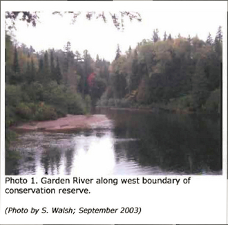
Photo 2. Garden River upstream from old dam; west side of conservation reserve.
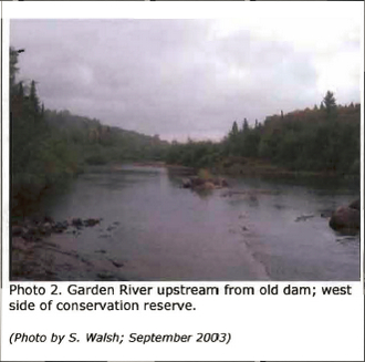
Photo 3. Remnants of dam on Garden River. (Photo by S. Walsh; September 2003)
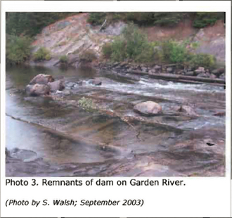
Photo 4: Remnants of the dam on Garden river (Photo by S. Walsh; September 2003)
(Photo by S. Walsh; September 2003) (Photo by S. Walsh; September 2003)
Photo 5. View over conservation reserve from northeast corner toward west/southwest. Lake is on northern boundary of site. (Photo by P. Burtch; November 1999)
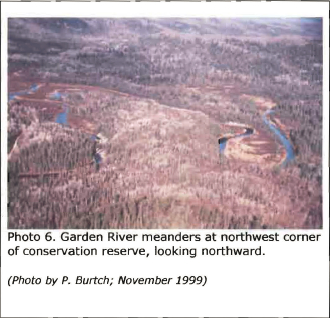
Photo 6. Garden River meanders at northwest corner of conservation reserve, looking northward. (Photo by P. Burtch; November 1999)
Photo 7. Mile 11 Road at Garden River. (Photo by S. Walsh; September 2003)
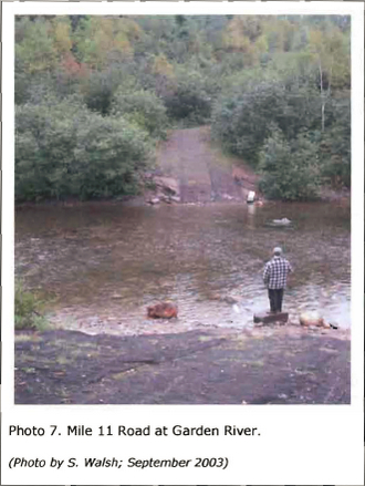
Photo 8. Falls on Garden River at location of dam; west boundary of conservation reserve. (Photo by P. Burtch; November 1999)
Appendix C: Test of Compatibility
Test of Compatibility
The Conservation Reserve policy provides broad direction with regard to the permitted uses. The policy provides only an indication of the variety of uses that will be considered acceptable in conservation reserves. Any new uses, and commercial activities associated with them, will be considered on a case by case basis, and, subject to the following test of compatibility. To ensure a standard screening process is followed, reviews of all current and new activities will be subject to the screening criteria as specified by the Environmental Assessment Act (RSO 1900, Chapter E.l8).
The following outlines the two steps involved in performing a Test of Compatibility. An assessment of current activities would only follow step two, which focuses on the impacts. An assessment of any new activity would consider the impact of the activity and its conformity to the SCI/RMP.
1. Conformity to SCI/RMP: SCI describe values for which an area has been set aside and the range of appropriate uses that will be permitted in the area. SCI may also speak to the acceptability of other 'new' uses currently not occurring in the area.
The first 'test' is: "do proposed new land uses and/or commercial activities conform to the direction of the SCI/RMP for the conservation reserve? Would the new use(s) depart from the spirit of appropriate indicator land uses in the SCI/RMP?"
2. Impact Assessment: If the proposed use(s) pass test 1 it is important to determine their impact on the area before they are approved. This should include the following:
- Impact on natural heritage values: "will the new use(s) impact any natural values in the area? If so how and to what degree? Is it tolerable?"
- Impact on cultural values: "will the new use(s) impact historical or archaeological values in the area?"
- Impact on research activities: "will the new use(s) affect research activities in the area?"
- Impact on current uses: "will the new use(s) have any negative impact on the array of current uses?"
- Impact on area administration: "will the new use(s) increase administrative costs and/or complexity?" (For example, the cost of area monitoring, security and enforcement).
- Impact on accommodating the use outside the conservation reserve: "Could the use(s) be accommodated as well or better outside the conservation reserve?"
- Impact on socio-economics of the area: "will the new use(s) affect the community(ies) surrounding the area in a positive or negative way?" (For example, will the new use make an area less remote thereby affecting a local tourism industry that is dependent on the area’s remoteness for its appeal?"
- Impact on area accessibility: "does the new use(s) give someone exclusive rights to the area or a portion of the area to the exclusion of other existing uses?"
Appendix D: Summary of permitted uses
The following Policy Report was obtained from the Crown Land Use Atlas website during completion of this SCI (fall 2003). Changes may have been made to this policy report since that time. For the most recent version of this policy report, please refer to the Crown Land Use Atlas on the Internet at http://crownlanduseatlas.mnr.gov.on.ca or contact your local Ministry of Natural Resources office.
Crown Land Use Atlas - Policy report
ID: C263
Area Name: Garden River Forest
Area (ha): 299
Designation: Conservation Reserve (Ontario’s Living Legacy)
District(s): Sault Ste. Marie
Description:
This conservation reserve, in Site District 4E-3 contains yellow birch and balsam fir dominated forest types growing on low hills of glacial deposits. The site also contains an old growth white pine forest that stretches up the slope into more rugged country, and small areas of medium aged white spruce and sugar maple forest. There is a four km stretch of riparian (shoreline) vegetation along the river that is also significant.
Garden River Forest was regulated as a conservation reserve on December 21, 2000.
Land use intent:
Management of this area is also governed by the general policies contained in the Land Use Strategy (1999).
Management direction:
Those uses and management activities not listed in the following table are governed by existing conservation reserve policy. Over time the management direction will be elaborated in a Statement of Conservation Interest or Resource Management Plan. Any new uses, and commercial activities associated with conservation reserves, will be considered on a case by case basis, and they must pass a test of compatibility to be acceptable. Compatibility is normally determined through a planning process.
Commercial activities
| Activity | Permitted | Guidelines |
|---|---|---|
| Aggregate Extraction | No | |
| Bait Fishing Existing: | Yes | Existing use permitted to continue, unless there are significant demonstrated conflicts. |
| Bait Fishing New: | Maybe | New operations can be considered, subject to the "test of compatibility". |
| Commercial Fishing Existing: | Yes | Existing use permitted to continue, unless there are significant demonstrated conflicts. |
| Commercial Fishing New: | Maybe | New operations can be considered, subject to the "test of compatibility". |
| Commercial Fur Harvesting Existing: | Yes | Existing use permitted to continue, unless there are significant demonstrated conflicts. Existing trap cabins can continue; new cabins are not permitted. |
| Commercial Fur Harvesting New: | Maybe | New operations can be considered, subject to the "test of compatibility". |
| Commercial Hydro Development | No | |
| Commercial Timber Harvest | No | |
| Commercial Tourism Existing: | Yes | Existing authorized facilities can continue, unless there are significant demonstrated conflicts. |
| Commercial Tourism New: | Maybe | New tourism facilities can be considered during the planning for an individual reserve. |
| Bear Hunting by Non-residents (guided) Existing: | Yes | Existing authorized operations permitted to continue. |
| Bear Hunting by Non-residents (guided)New: | No | New operations not permitted. |
| Outfitting Services Existing: | Yes | Existing authorized operations permitted to continue. |
| Outfitting New: | Maybe | New Existing: M operations can be considered during the planning for an individual reserve. |
| Outpost Camps Existing: | Yes | Existing authorized operations permitted to continue. |
| Outpost Camps New: | Maybe | New operations can be considered during the planning for an individual reserve. |
| Resorts/lodges Existing: | Yes | Existing authorized facilities permitted to continue. |
| Resorts/lodges New: | Maybe | New facilities can be considered during the planning for an individual reserve. |
| Boat Caches (Managed): | ||
| Energy Transmission and Communications Corridors Existing: | Yes | These facilities should avoid conservation reserve lands : wherever possible. |
| Energy Transmission and Communications Corridors New: | No | These facilities should avoid conservation reserve lands : wherever possible. |
| Food Harvesting (Commercial) Existing: | Maybe | |
| Food Harvesting (Commercial) New: | Maybe | |
| Mineral Exploration and Development | No | |
| Peat Extraction | No | |
| Wild Rice Harvesting Existing: | Yes | |
| Wild Rice Harvesting New: | Maybe |
Land and resource management activities
| Activity | Permitted | Guidelines |
|---|---|---|
| Crown Land Disposition Private Use: | Maybe | Sale of lands is not permitted, except for minor dispositions in support of existing uses (e.g. reconstruction of a septic system). Renewals of existing leases and land use permits are permitted. Requests for transfer of tenure will be considered in the context of the Statement of Conservation Interest or Resource Management Plan. |
| Crown Land Disposition Commercial Use: | Maybe | New leases or land use permits permitted for approved activities. Tourism facilities can apply to upgrade tenure from LUP to lease. |
| Fire Suppression | Yes | Fire suppression policies are similar to adjacent Crown lands, unless alternative fire policies have been developed through a planning process. |
| Fish Habitat Management | Maybe | |
| Fish Stocking | Maybe | Conservation Reserves policy indicates that "featured species management" may be permitted. |
| Insect/disease Suppression | Maybe | |
| Inventory/Monitoring | Yes | |
| Prescribed Burning | Maybe | |
| Roads (Resource Access) Existing: | Yes | Existing roads can continue to be used. Continued use will include maintenance and may include future upgrading. |
| Roads (Resource Access) New: | Maybe | New roads for resource extraction will not be permitted, with the exception of necessary access to existing forest reserves for mineral exploration and development. |
| Vegetation Management | Maybe | Conservation Reserves policy indicates that Featured Species Management and Natural Systems Management may be permitted. Vegetation management can be considered in a planning process. |
| Wildlife Population Management | Maybe |
Science, education and heritage appreciation
| Activity | Permitted | Guidelines |
|---|---|---|
| Collecting | No | |
| Historical Appreciation | Yes | |
| Nature Appreciation | Yes | |
| Photography and Painting | Yes | |
| Research | Yes | |
| Wildlife Viewing | Yes | |
Recreation, activities and facilities
| Activity | Permitted | Guidelines |
|---|---|---|
| All Terrain Vehicle Use On Trails: | Yes | Existing use permitted to continue where it does not adversely On Trails: affect the values being protected. |
| All Terrain Vehicle Use Off Trails: | No | ATV use off trails is not Off Trails: permitted except for direct retrieval of game. |
| Campgrounds | Maybe | |
| Food Gathering | Yes | |
| Horseback Riding (trail) | Yes | Existing use on trails permitted. |
| Hunting | Yes | |
| Mountain Bike Use | Yes | Existing use on trails permitted. |
| Motor Boat Use Commercial: | Yes | |
| Motor Boat Use Newl: | Yes | |
| Non-motorized Recreation Travel | Yes | |
| Private Recreation Camps (Hunt Camps) Existing: | Yes | Existing camps permitted to continue, and may be eligible for enhanced tenure, but not purchase of land. |
| Private Recreation Camps (Hunt Camps) New: |
No | |
| Rock Climbing | Maybe | |
| Snowmobiling On Trails: | Yes | Existing use permitted to continue where it does not adversely affect the values being protected. |
| Snowmobiling Off Trails: | Maybe | Snowmobile use off trails is Off Trails: not permitted, except that snowmobiles may be used for direct retrieval of game. |
| Sport Fishing | Yes | |
| Trail Development Existing: | Maybe | Development of trails for a variety of activities (e.g. hiking, cross-country skiing, cycling, horseback riding, snowmobiling) can be considered as part of planning for an individual reserve. |
| Trail Development New: | Maybe | Development of trails for a variety of activities (e.g. hiking, cross-country skiing, cycling, horseback riding, snowmobiling) can be considered as part of planning for an individual reserve. |
Note: The policies outlined in this table do not supersede any Aboriginal or treaty rights that may exist, or other legal obligations.
Management of this conservation reserve is carried out within the context of Conservation Reserve policy as amended by the policies for new conservation reserves outlined in the Ontario’s Living Legacy Land Use Strategy.
Source of Direction:
Ontario’s Living Legacy Land Use Strategy (1999)
Conservation Reserves Policy (1997)
Sault Ste. Marie District Land Use Guidelines (1983)
Appendix E: Regulation public consultation materials
Note that some information in these materials is no longer current - the documents are provided here as a matter of historical record.
***Unreadable Letter - cannot remediate***
Garden River Forest Conservation Reserve (c263) fact sheet
January, 2001
Background
On July 16. 1999, the Ontario Government released Ontario’s Living Legacy Land Use Strategy to guide the planning and management of Crown lands in central and parts of northern Ontario. A major part of Ontario’s Living Legacy Land Use Strategy was a government intent to establish 378 new protected areas. This commitment marks the biggest expansion of provincial parks and conservation reserves in Ontario’s history.
The Garden River Forest Conservation Reserve is part of this significant expansion of Ontario’s protected areas system. Following public and aboriginal consultation in late 1999 and early 2000 on refining the boundary of this protected area, Ontario Regulation 805/94 of the Public Lands Act was amended on January 6, 2001, by Ontario Regulation 686/00, to formally establish this conservation reserve.
Size and location
The Garden River Forest Conservation Reserve is located approximately 50 km north of the Town of Bruce Mines in Curtis Township. It extends north from Castleman Lake, and is 299 ha in size.
Area highlights
This conservation reserve is located in an area known by resource managers as "ecological site district 4E-3," an ecological unit extending roughly from Gogama and Chapleau in the north to Sudbury and Elliot Lake in the south. Located on the Precambrian Canadian Shield, site district 4E-3 is characterized by a rocky landscape disected by numerous folds and faults.
The Garden River Forest Conservation Reserve contains landform and vegetation combinations which are poorly represented in the province. Yellow birch and balsam fir dominated forests are found growing on low hills formed of glacial deposits left behind during the last Ice Age. The site also contains an old growth white pine forest that stretches up the slope into more rugged country, and small areas of medium-aged white spruce and sugar maple forest.
Also included within the reserve is a 4-km stretch of riparian (shoreline) vegetation bordering the Garden River, a small headwater pond and tributary feeding into the river, and adjacent steep slopes and forests that provide recharge functions for the river.
While a detailed biological study has not been conducted within the conservation reserve, a number of significant and/or sensitive species are known to be present within site district 4E-3. The regionally significant three-toed woodpecker breeds here, as do the sedge wren, pine grosbeak, and northern rough-winged swallow. This site district also forms the northern limits of the range of the increasingly rare snapping turtle, the four-toed salamander, the bullfrog, and the chorus frog. Rare vascular plants recorded in the area include the limestone oak fern. Clinton’s club-rush. and the monkey flower.
Land use intent
Conservation reserves are areas of Crown land set aside by regulation under the Public Lands Act.
Conservation reserves complement provincial parks in protecting representative natural areas and special landscapes. Most recreational activities (e.g. hiking, skiing, tourism related uses. nature appreciation) and non-industrial activities (e.g. fur harvesting, commercial fishing and bait harvesting) that have traditionally been enjoyed in the area will continue, provided that these uses do not impact on the natural features needing protection. Hunting and fishing are also permitted within all new conservation reserves proposed through Ontario’s Living Legacy.
Commercial timber harvesting, mining, aggregate extraction and commercial hydroelectric development are prohibited in conservation reserves. Careful mineral exploration may occur in specific new conservation reserves proposed through Ontario’s Living Legacy. in areas that have provincially significant mineral potential. If a portion of a new conservation reserve is to be developed for a mine, it would be removed from the reserve, and appropriate replacement lands would be placed into regulation. Please refer to Table 4 from the Land Use Strategy for a detailed summary of permitted uses in conservation reserves.
Next steps
This regulated area has been withdrawn and protected from resource extraction activities such as timber harvesting, hydroelectric development, aggregate extraction and new mineral exploration.
In the future, the Ministry of Natural Resources will prepare a long-term management plan for this area. Depending upon the complexity of issues within this conservation reserve, management planning may take the form of a simple Statement of Conservation Interest or a more detailed Resource Management Plan. Please let us know if you would like to be notified when planning begins.
Planning, management and the uses permitted within this conservation reserve would be consistent with the commitments of Ontario’s Living Legacy Land Use Strategy.
For more information
For further information on the Garden River Forest Conservation Reserve, please contact Erin Nixon, District Planner, Ministry of Natural Resources, Sault Ste. Marie District (
64 Church Street
Sault Ste. Marie, ON P6A 3H3
August 22, 2001
Regulation of Ontario’s Living Legacy Protected Areas in Sault Ste. Marie District
In July 1999, the Ontario Government released the Ontario’s Living Legacy Land Use Strategy, a broad land use approach to the planning and management of Crown lands in central and parts of northern Ontario. A large component of the Ontario’s Living Legacy Land Use Strategy was a government commitment to add 378 new provincial parks and conservation reserves to Ontario’s protected areas system.
In November 1999 and again in September 2000, we provided you with the opportunity to comment on the proposed boundaries for the park and the conservation reserves in Sault Ste. Marie District. Iam pleased to inform you that, as of January 2001, the park and fifteen of these conservation reserves have been regulated. The new park and conservation reserves in the District are:
P285 Sandy Islands Provincial Nature Reserve
C243 Wagong Lake Forest Conservation Reserve
C244 Rawhide Lake Conservation Reserve
C245 Jollineau Conservation Reserve
C246 Echo River Hardwoods Conservation Reserve
C258 Thessalon River DeltalRock Lake Red Oak Conservation Reserve
C260 Rose Lake Dune Peat/and Complex Conservation Reserve
C262 Stuart Lake Wetland Conservation Reserve
C263 Garden Lake Forest Conservation Reserve
C281 Tilley Creek West Conservation Reserve
C284 Wabos North Conservation Reserve
C286 Wabos South Conservation Reserve
C289 Searchmont South Forest Conservation Reserve
C294 O'Connor Conservation Reserve
C298 Harmony Forest Conservation Reserve
C307 lie Parisienne Conservation Reserve
Regulation means the park and conservation reserves are now legally mapped and recognized as protected areas of crown land under the jurisdiction of the provincial government. As such, these areas will be protected from industrial activities, including commercial forestry, hydroelectric development, mining, and aggregate and peat extraction. Traditional recreational and resource uses such as hunting, fishing, hiking, canoeing, boating, and fur trapping, will generally be permitted to continue within the conservation reserves. In nature reserve class provincial parks (eg. P285, Sandy Islands), hunting and fur trapping are not permitted; other traditional recreational uses (fishing, hiking, canoeing, boating) may continue.
Ontario Parks staff is responsible for the planning and management of Sandy Islands Provincial Nature Reserve and they will prepare an Interim Management Statement to guide the management of this property. Sault Ste. Marie District is responsible for the management of the conservation reserves and will develop Statements of Conservation Interest (SCI) to guide the management of each new conservation reserve. There will be opportunity for the public to review and comment on draft SCIs for each conservation reserve. Depending upon the complexity of issues related to the sites and their management, more detailed Management Plans may, in due course, be required.
Detailed maps of the regulated boundaries for these new protected areas are available for viewing in the Sault Ste. Marie District office and the Blind River Area office of the Ministry of Natural Resources.
If you have any questions or concerns about the management of Sandy Islands Provincial Nature Reserve, please contact Chris Caldwell, Ontario Parks at the Sault Ste. Marie District Office. Concerns regarding any of the conservation reserves, should be addressed to Sheila Walsh (OLL Resource Planner) also at the Sault Ste. Marie District Office.
Thank you for your interest in Ontario’s Living Legacy. Yours truly,
Tom Mispei-Beyer
acting District Manager
Sault Ste. Marie District
Telephone:
Facsimile:
E-mail: tom.mispelbeyer@mnr.gov.on.ca