Jog Lake Conservation Reserve Management Statement
This document provides policy direction for the protection, development and management of the Jog Lake Conservation Reserve and its resources.
Statement of Conservation Interest
December, 2001
Approval statement
I am pleased to approve this Statement of Conservation Interest (SCI) for the Jog Lake Conservation Reserve (CR).
Direction for establishing, planning and managing conservation reserves is defined under the Public Lands Act and current policy. “Ontario’s network of natural heritage areas has been established to protect and conserve areas representative of the diversity of the natural regions of the province, including species, habitats, features and ecological systems which comprise that natural diversity.” (Policy 3.03.05, MNR 1997).
This SCI will provide guidance for the management of the conservation reserve and the basis for the ongoing monitoring of activities. More detailed direction at this time is not anticipated. Should significant facility development be considered or complex issues arise requiring additional studies, more defined management direction or special protection measures a more detailed conservation reserve Resource Management Plan (RMP) will be prepared with full public consultation.
The public was consulted prior to Jog Lake Conservation Reserve’s regulation. Comments and concerns registered then are reflected in this Statement of Conservation Interest.
The conservation reserve will be managed under the jurisdiction of the Missinaibi West Area Supervisor of the Ministry of Natural Resources, Hearst District.
Submitted and signed by:
Kathryn Durst
Plan Author
Date: December 04, 2001
District Manager Recommendation
Date: December 04, 2001
Approved and signed by:
Rob Galloway
Regional Director
Northeast Region
Date: January 07, 2002
1.0 Introduction
Jog Lake Conservation Reserve (CR) totals 48,482 hectares (ha) in size and is located in Hills (1959) Site District 2E1 at the south edge of the Ontario Hudson Bay Lowland (OHBL). The Reserve is 70 km north of Highway 11 situated between the towns of Hearst and Longlac, Ontario. Jog Lake Conservation Reserve is located partly within the Hearst District in the Northeast Region and partly in Nipigon District, Geraldton Area in the Northwest Region at 50° 11′ N and 85° 20′ W (Section 8.1, Figure 1).
Jog Lake is a large, circular, bog-rimmed lake, which is the high point of the area and an excellent example of boreal muskeg. Drainage occurs in a radial pattern outwards from the lake. Graminoid bogs, fens, open and treed bogs are prevalent in the area of the reserve. A small rock outcrop, which lies close to the center of the conservation reserve between unnamed lake and the Watistiguam River, was once considered created by a meteor. However, discussions with Phil Kor, Ontario Parks Conservation Geologist and John E. Thompson, Ontario Parks natural heritage specialist, suggest that both lakes and the small rock ridge are not the results of a meteor impact (P. Kor pers. comm.). The mountain within the conservation reserve rises to a high point over 100 meters (approximately 220m contour) overlooking the peatand.
In 1988, an area of 50,500 ha centered around Jog Lake was proposed as an Area of Natural and Scientific Interest (ANSI). In 1994, the Jog Lake proposed ANSI was one of the 30 proposed protected areas brought forward for regulation under the Keep It Wild (KIW) protection plan and at that time was listed as a Nature Reserve. However, the entire proposed ANSI and the Nature Reserve classification did not come forward under the Keep It Wild program. Some 2,018 ha along the site’s current regulated northern boundary were dropped in response to mining activity present at that time within this northern portion. Furthermore, the provincial park’s nature reserve classification was changed to the then new conservation reserve classification to enable a wider suite of recreational activities including sport hunting. Finally, Jog Lake was regulated as a conservation reserve in January 1997.
Conservation reserves complement provincial parks in protecting representative natural areas and special landscapes. Most recreational (e.g. hiking, skiing, tourism related uses and nature appreciation) activities that have traditionally been enjoyed in the area will continue, provided that these uses do not impact on the natural features needing protection. Consumptive recreational activities such as sport hunting and fishing are permitted activities within all new conservation reserves as per policy PL 3.03.05 (Section 9.6).
Statement of Conservation Interest (SCI) documents are the minimum level of management direction established for any conservation reserve and generally are brief management plans. This SCI will govern all the lands and waters within the regulated boundary of Jog Lake Conservation Reserve. The purpose of this SCI is to identify and describe the values of Jog Lake Conservation Reserve as well as provide management direction that will protect its natural and cultural heritage values and demonstrate its compatibility within a larger landscape. In addition, to ensure MNR protection objectives are being fully met within the conservation reserve, the surrounding landscape and related activities must consider the site’s objectives and heritage values. Finally it is the intent of this SCI to create a public awareness that will promote responsible stewardship of the protected area and surrounding lands.
2.0 Goal and objectives
2.1 Goal of the Statement of Conservation Interest (SCI)
The goal of Jog Lake Conservation Reserve is to describe and protect natural heritage and cultural values on public lands while permitting compatible land use activities.
2.2 Objectives of SCI
2.2.1 Short term objectives
The short-term objectives will focus on the identification of the current State of the Resource with respect to natural heritage values and current land use activities within the conservation reserve. A priority will be placed on the protection of the site’s natural values via specific guidelines, strategies and prescriptions detailed in this plan. Finally, planning requirements, as legislated, will be met (e.g. SCI development within three years of regulation).
2.2.2 Long term objectives
The long-term objectives will be to maintain representative targets (e.g. future peatland conditions) and validate the site as a potential scientific benchmark. To ensure protection of natural and cultural heritage features and values, this SCI will establish an evaluation process to address future new uses and commercial activities associated with them (e.g. Test of Compatibility Procedural Guidelines 8 in conservation reserve policy PL 3.03.05). Finally, this SCI will identify research/client services delivery and marketing strategies.
3.0 Management planning
3.1 Planning area
The planning area as previously discussed is the regulated boundary as illustrated in Figure 1, Section 8.1. This landbase will form the area directly influenced by this Statement of Conservation Interest. The plan will recognize the protection of values within the planning area, however, to fully protect values within the conservation reserve additional consideration within larger land use or resource management plans may be required. Never the less, any strategies noted within this plan related to the site’s boundary or beyond will need to be presented for consideration within a larger planning context.
3.1.2 Management planning context
The Jog Lake site has been an area of interest to the Ministry of Natural Resources since at least the early 1960’s (McEwan 1964). However, the first comprehensive review of the area occurred in 1981 as part of a larger set of candidate parks reviewed by J.L. Riley (Riley 1981). In 1988, D.F. Brunton completed a Statement of Interest for Jog Lake Area of Natural and Scientific Interest (ANSI) with the establishment of the proposed ANSI of some 50,500 ha in size. However by the early 1990s MNR listed the site as still a proposed ANSI (MNR 1992). In 1993 this area was reported on through the Endangered Spaces Candidate Area Report series with future ministerial and public consultation occurring during the early 1990’s resulting in a reduced area (48,482 ha) and a change in protection mechanism from provincial park nature reserve to conservation reserve. Eventually, Jog Lake Conservation Reserve was regulated under an amendment of Ontario Regulation 805/94 made under the Public Lands Act on January 1, 1997.
The regulation of this conservation reserve predates MNR’s Ontario Living Legacy Land Use Strategy (MNR 1999) therefore the direction for this SCI will be governed by the Public Lands Act and associated policy PL 3.03.05 dated February 11, 1997. By regulation this conservation reserve cannot be used for mining, commercial forest harvest, hydroelectric power development, the extraction of aggregate and peat or other industrial uses. The Hearst District Land Use Guidelines (DLUG) specifies that the conservation reserve is part of its Resource Utilization area. However, Geraldton Area does not have an approved DLUG. Currently the surrounding landscape is not managed for timber production and is not committed to harvesting.
Traditional uses within the conservation reserve will continue to be permitted, therefore, such activities as sport hunting, fishing and existing bear hunting is permitted to continue. This SCI and future management will continue to try and resolve conflicts regarding incompatibility between uses and to ensure that identified values are adequately protected.
Once a Conservation Reserve is passed into regulation, it must be determined what level of management planning is required to fulfill the protection targets. This Statement of Conservation Interest will only address known issues or current proposals with respect to permitted uses or potential economic opportunities brought forward to the District Manager during this planning stage. However, in terms of approving future permitted uses and/or development(s), there are established mechanisms in place to address such proposals. Any future proposals will be reviewed using the Procedural Guideline B - Land Uses - Test of Compatibility Public Lands Act Policy PL 3.03.05 (MNR 1997) or other MNR environmental screening processes.
Consideration for proposals pertaining to cultural resources may be screened through Conserving a Future for our Past: Archaeology, Land Use Planning & Development in Ontario, Section 3 (MCzCR, 1997) and MNR’s history in establishing Area of Concern (AOC) descriptions and prescriptions for cultural heritage resources within forest management plans (FMPs)
These planning tools will help refine the review process once the proposal satisfies the direction and intent of the Public Lands Act, associated policies and this planning document.
3.2 Planning process
There are two policy documents that address the planning process; a Statement of Conservation Interest (SCI) is the minimal requirement for providing planning direction and a Resource Management Plan (RMP) that deals with more complex issues (where several connicting demands are placed on the resources). The guidelines for the preparation of these documents is outlined in Procedural Guideline A - Resource Management Planning (Conservation Reserves Procedure PL 3.03.05 Public Lands Act). The appropriate plan must be completed within three years of the regulation date.
For current planning purposes, the Jog Lake Conservation Reserve will be managed under the auspices of a SCI. In 1994, 30 areas were proposed for protection under KIW campaign - Jog Lake was one of these areas and was covered by an Environmental Assessment Exemption Order (MNR 61). As part if its KIW program, the Ministry of Natural Resources invited the public to comment on the proposal to create a Provincial Nature Reserve (NR). Public consultation, in the form of an open house and information center, took place in 1994. Eventually the site’s size was reduced from the original ANSI and its designation changed 'from nature reserve to conservation reserve and regulated in 1997.
The intent of this SCI is to fulfil the commitments made under the Public Lands Act and associated policies. The public was consulted during the conservation reserve’s creation and final regulation. The responses and concerns brought forward during that consultation period are reflected in this Statement of Conservation Interest.
Public consultation will be solicited during a review of any future land use proposals that would require new decisions to be made. In addition, any future proposal and/or any new, significant management direction considered will be published on the Environmental Bill of Rights registry (EBR).
The SCI is a policy document that will provide background information, identify values to be protected and establish management guidelines for use in the administration of the reserve.
The implementation of the policy will be the mandate of the MNR at the district level, however associations with various partners may be sought to assist in the delivery. It must be noted that this SCI is a working document and it will be necessary to make revisions to it from time to time.
4.0 Background information
4.1 Location and site description
4.1.1 Location
Table 1 and Figure 2 in Section 8.0 describe the location and provide administrative details of the site:
Table 1: Location and administrative details for Jog Lake
[Table 1 converted into a list
- Name: Jog Lake Conservation Reserve
- Site Region - Site District (Hills): 2E James Bay- 2E1 Albany
- Site Region - Site District (Crins and Uhlig):
- MNR Administrative Region/District/Area: Northeast/Hearst/Kapuskasing
- Total Area: 48,482 ha
- Regulation Date: January 1, 1997
- First Nations: Constance Lake, Martin Falls and Ginoogaming (Longlac)
- OBM map sheets: No Coverage
- UTM Coordinates: 191540E 5585479N
- Municipality: Nil
- Township: Nil
- Status: 100% Crown lands
4.1.2 Site description
4.1.2.1 Physical description
Jog Lake Conservation Reserve is a 48,482 ha parcel of Crown land that is situated in northeastern Ontario 70 km north of Highway 11 between the towns of Hearst and Longlac, within the Ontario Hudson Bay Lowland (OHBL). With the passing of the last ice age and the final retreat of the Wisconsin age glaciers that covered this area about 8000 years ago, the Lowland was invaded from the north by seawaters. The Tyrell sea, an expansion of the present Hudson and James Bay, covered the Lowland an slowly receded as the lands rebounded from the weight of the glacial ice. This left a wide flat seabed plain composed mainly of lacustrine deposited clays and silts. Gradually deep peat and organic overburdens resulting from accumulated vegetative buildup occurred and primitive drainage systems began to develop.
Jog Lake Conservation Reserve is located within unorganized townships, divided between Hearst District within the Northeast Region and Geraldton Area in Nipigon District, within the Northwest Region. The conservation reserve lies within Hills (1959) Site Region 2E and Site District 2E-1 an area that is characterized by muskeg plain underlined by clay. This landscape is treeless wetland or sparse spruce forests or spruce-poplar forests relegated to riverbanks, occasional eskers or moraine ridges where drainage is generally improved. Overall drainage is poor with peat and peat glei
The key values within the conservation reserve include the following:
- A large, pristine, provincially significant landscape of continuous patterned and raised peat plateau complex typical of the Hudson Bay Lowland;
- A radial patterned drainage out flowing from Jog Lake
- The presence of a deciduous swamp/forest located on a hill south of the Watistiguam River.
Such a large lake as Jog Lake captured within the conservation reserve is somewhat unusual for the OHBL. The small “mountain” south of Jog Lake, is a major irregularity in this area and is a single nodal, high point of over 30 meters overlooking the peatlands. On top of the hill is a small deciduous swamp/forest that is unusual in this type of wetland pattern.
Much of the area remains with primitive drainage in place. Jog Lake is the high point in the area. A conical drainage pattern occurs but mainly through a subsurface seepage in all directions through the peat soils. The contour lines tend to circle Jog Lake for many kilometers out from the Lake to the south falling only a meter in the first 1.5 kilometers. A small stream that flows south into the Watistiguam River drains Jog Lake. The larger Watistiguam River generally flows east to southeast crossing the southern portion of the site and with the Mundino River eventually the conservation reserve is drained by the Kenogami and Albany rivers, which are part of the arctic watershed.
The Jog Lake area gently slopes outwards in all directions from the lake, which is situated at 628 ft. (191 m) above sea level. The 625 ft. (190 m) contour lies close to an average distance of 6 km out from and circling Jog Lake. The 600 ft. (183 m) contour lies about 12 km average distance out from Jog Lake indicating a very gentle, almost flat, outwardly sloping plain from the lake. South of the Watistiguam River and approximately eight kilometers to the southwest of Jog Lake lies a noticeable hill, which towers up to 725 ft. (221 m) above sea level. This is the highest point on the site and is a major irregularity in this area and probably created after the recession of the Tyrell Sea.
There is a 9 km long and 2 km wide belt around Jog Lake of randomly scattered deposits that lie above the surrounding peatlands.
Just to the north of the Mundino River, a second small parallel belt of randomly scattered raised deposits lay in an east-west orientation some 14 km to the southwest of Jog Lake. These airborne deposits are much smaller than the northerly group. The parallel lineament of the two deposits belts, about five kilometres apart, lie southwest of Jog Lake and may well be the reason for the magnetic band indicated on aeromagnetic mineral surveys in this area and to the south of Jog Lake.
4.2 Administrative description
The legal boundaries of the Jog Lake Conservation Reserve were certified by the Ministry of Natural Resources and the Surveyor General of Ontario on the 31st of January 1997. It was passed into regulation on January 1st, 1997 (O.Reg. 259/97 Schedule 12). Presently the conservation reserve is located north of the “Area of the Undertaking” and therefore the site and surrounding landscape are not currently licensed for forest harvesting. See Figure 5, Section 8.0.
4.3 History of the site
First Nations of the area may have wandered onto and utilized Jog Lake or some of the larger streams during winter hunting or trapping trips within the Jog Lake Conservation Reserve and proposed ANSI to the north. There are no identified aboriginal campsites or any other indication of any extensive time spent within the current conservation reserve. It may be that the lake and area were not known prior to being intersected by survey crews in the early 1900’s. This due to the lack of direct navigable waterways and vast stretches of wetland separating the conservation reserve from any of the traditional gathering places of those bands that in the past traveled that area. Further investigations of First Nation use may be warranted.
4.4 Inventories
The following table indicates what Survey work has been done and what is required:
Table 2: Inventory and survey information for Jog Lake
| Survey Level | Earth Science | Life Science | Cultural | Recreational | Other | |
|---|---|---|---|---|---|---|
| Reconnaissance Survey (RS) | N/A | 1981 Riley, J.L. Site information and Surveys: McEwan 1964 Veg Map @ scale 1:1000000 and Sparling 1973. |
N/A | N/A | OCRS Reconnaissance, July 11, 12, 1979 Fact Seet for Jog Lake by MNR Statement of Interest for Jog Lake ANSI, March 1988. Endangered Spaces Report, Ontario’s Natural Heritage |
|
| Detailed | N/A | N/A | N/A | N/A | N/A | N/A |
| Requirement | RS required | RS required | Update required with Local First Nations | RS required | Life science inventory should include completing aquatic habitat inventory for the major lakes and rivers within the site, if time and dollars permit. |
5.0 State of the resource
Representation:
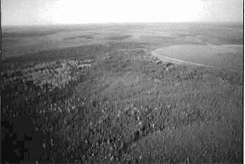
Jog Lake Conservation Reserve is located within the Moose River Basin of the Hudson Bay Lowland - a huge area of Precambrian rock which is largely covered by flat lying younger Paleozoic, Silurian sedimentary rocks. These sedimentary rocks are in turn covered with extensive surface deposits of peat, clay and sand (Bostock 1970 and MNR 1985). Early vegetation reconnaissance mapping was completed by Riley (1981) (see Section 8.3 Figure 3). This analysis identified nine broad vegetative classes. Most of the site is characterized as a pristine, patterned and raised peat plateau complex comprised of raised and open bogs
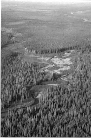
Figure A: The Watistiguam River area
(i) South shoreline of unknown lake south of Watistiguam River showing treed bog vegetation along southern shore and patterned open low shrub bog and fen areas in the near background.
(ii) Shoreline fens located along the Watistiguan River. (Photographs by Phil Kor).
Quality of present representation:
The quality of the representation or the current characteristics of the natural features found within the conservation reserve are as important as the overall representative features that are being protected. A number of factors are considered in evaluating a site and they include the following criteria; diversity, condition, ecological factors, special features and current land use activities.
a) Diversity:
Diversity is evaluated in terms of the number and range (i.e. amount of richness and evenness) of vegetative communities currently present within the conservation reserve. Natural landscapes and known generalized vegetative communities will be the scale used for this SCI. Future aerial or ground reconnaissance surveys will enhance the MNR’s knowledge of these features and possibly allow verification at a lower scale (e.g. species assemblages).
Based on Riley (1981) vegetative classifications Jog Lake Conservation Reserve contains a fair number of vegetative communities, considering it is located within the large wetland feature known as the Hudson Bay Lowland. Such vegetative diversity is in response to water flows within the lakes, creeks, and rivers or through surface water or topography - especially on the small hill to the south that contains deciduous forest. In addition, the site is dominated by landscape elements that contribute to the natural heritage richness of Ontario. For Jog Lake the following are considered; Jog Lake a raised peat-margined lake, raised peatland complex (Figure C) that has radial drainage patterning (Figure B) out from Jog Lake and ground moraine hill associated with deciduous swamp. In addition, the pristine nature of the conservation reserve, its location within the remote Hudson Bay Lowland and the absence of industrial activity within this wilderness setting all contributes significantly to the richness of Ontario’s natural heritage features.
Figure B: Jog Lake looking southwest showing typical radial drainage pattern out flowing from the lake. (Photograph by Phil Kor)
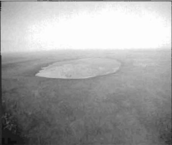
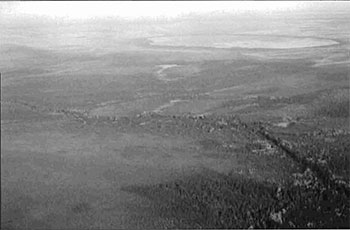
Figure C: Large, pristine, raised peatland complex south of Jog Lake. (Photograph by Phil Kor)
[Missing text] predominately open and treed bog but that dominance is reduced somewhat by the presence of the other vegetative communities mostly concentrated south of Jog Lake. These additional communities increase the evenness of the diversity found within the site’s borders. Finally, much of the predominately open graminoid fen rests within the proposed ANSI to the north of the site. This fen diversity is rather restricted to the conservation reserve’s northeastern sections and would be increased if the northern proposed ANSI was ever added to Jog Lake Conservation Reserve.
b) Condition:
Condition is the degree of past human and natural disturbances observed or recorded for the site. The site is generally in a pristine condition with the exception of the east-west cutting and survey of the 7th baseline and the northsouth survey line along 85° 20′ west longitude. These lines were established over a number of years approximately 100 years ago (i.e. 1900) and have not been retraced since those times. There are no existing facilities or road access witt1in the conservation reserve.
c) Ecological factors:
Ecological factors refer to the current design of the conservation reserve as noted by its size, shape, buffering capacity to adjacent land use activities. In addition the site’s current linkage to undisturped landscapes also contribute to the conservation reserve’s ecological integrity. Presently, Jog Lake Conservation Reserve size of 48,482 ha would not meet a wilderness standard on its own and its overall straight line boundaries have severed the 625 ft. contour line and associated open fen communities north of the site. However the fact that the site rests within the larger, remote OHBL and currently has no industrial uses occurring along its borders or within the adjacent landscape allows the site to be completely linked to this vast, undisturbed landscape and compensates for the generally poor design of the site.
The site’s ability to buffer use within its borders is limited due to the sensitivity of the wetlands and landscapes found here. These old communities and landscapes that qr processes of low biological productivity are sensitive to most recreational activities that would be normally allowed within conservation reserves (PL 3.03.05). If low impact recreational activities were allowed to occur tight controls and probably a much larger area than the current site would be required to allow managers the flexibility to distribute use within the site.
d) Special features:
Special features include interesting landscapes, habitats or vistas, Species at Risk (SAR) and other earth and life science features including broader [missing text]
e) Current land use activities
Present activities are limited to possibly trapping; however the extent of this use is not well known.
5.1 Social/ economic interest in area
Heritage estate contributions:
Jog Lake Conservation Reserve contributes to the province’s parks and protected areas system by its regulation, representation and long term management of the site’s natural heritage values.
By allocating these lands to the parks and protected areas system through regulation the province has ensured a certain level of permanence by identifying the site and its values from the surrounding landscape.
The site’s representation makes a number of contributions to the provinces natural heritage estate. Firstly, as a relatively large, pristine site that contains patterned and raised peat plateau complex typical of the Hudson Bay Lowland. The fact that these lands have not been captured in any other protected area in the province makes this area provincially significant. The radial drainage pattern associated with Jog Lake and the deciduous swamp located on the hill south of the Watistiguam River are additional special features that increase the diversity of the site.
The conservation reserve’s relative remoteness and lack of current uses established within the site may help ensure that its fragile vegetative communities, waters and old growth systems are protected into the future. Furthermore its distinctiveness as an example of the larger OHBL landscape may distinguish this site as an important scientific benchmark in the years to come. Future managers will have to balance the need to maintain the quality of the current representation and the needs of current or future users.
Aboriginal interests:
First Nations may have, from time to time, used Jog Lake or some of the larger streams associated with the conservation reserve and the proposed ANSI to the north during winter hunting or trapping trips. There are no identified aboriginal campsites or any other indication of any extensive time spent by First Nations within the conservation reserve. This may be due to the lack of direct navigable waterways and vast stretches of wetland separating the conservation reserve from any of the traditional gathering places of those bands that, in the past, traveled the area. The Reserve falls in the area of Nishnawbe-Aski Nation (N.A.N) Treaty #9 (1905-06).
According to the contact person for Constance Lake trap lines, the trapper whose trap area includes the east part of the reserve has not trapped in the reserve. During public consultation in 1996, concern was that trapping and hunting by Natives might be restricted. Concern was expressed that fly-in hunting might decrease the market for Native guiding (guiding has not yet occurred). Existing activities such as trapping, hunting, fishing and guiding will continue, as per existing policy and Aboriginal and Treaty Rights will be respected.
Current land use and mining interest:
This reserve rests on Crown Land and is unencumbered. by any land use permits, leases or mining claims. An area just to the west of the reserve was staked, investigated and abandoned without any success a number of years ago. Mining and surface rights have been withdrawn from staking on the conservation reserve; however the proposed ANSI is still open to staking and mining (MNDM pers. comm.).
There are no commercial activities at present in the reserve, except for occasional fly-in hunting. There is no merchantable forest in the reserve.
5.2 Natural heritage stewardship
Riley (1981ab) evaluated Jog Lake Conservation Reserve for its life science representation. In that analysis of candidate life science areas, sites within the OHBL were evaluated on a regional basis using appraised published and unpublished site data, field visits and comparative analysis of biophysical and regional representation by candidate areas. Preliminary analysis of the life science targets showed that the site contained nine vegetative communities present on organic deposits. The variety, pattern and pristine nature of the wetland and forested communities achieved provincial significance status as a representative landscape of the Ontario Hudson Bay Lowland. Weakly broken and moderately broken ground moraines were associated with the small, unknown lake and hill south of the Watistiguam River (OFRI 1994) where a unique deciduous forest was also located. For details, see the life science check sheet in the Appendix 9.1 in the back of this plan.
No known significant earth science features are associated with this site; however, further investigations including a ground visit is warranted (Kor pers. comm.).
5.3 Fisheries and wildlife
Presently no fisheries data has been collected within the conservation reserve. The extent of the wetland communities, the probable bog like nature of the few lakes present within the site and the lack of access do not make the reserve a high priority for district fisheries staff to complete assessments or promote sport fishing.
To date, no detailed wildlife studies have taken place within the conservation reserve; hence the importance of the site to wildlife species particularly Species at Risk and their habitats have yet to be determined. Landscape, wildlife studies associated with Wildlife Management Unit 188, in which Jog Lake is located, include aerial moose surveys. The moose inventory study conducted in 2000 reported no moose within the Jog Lake boundaries.
Caribou data is sparse around the area of Jog Lake. Jog Lake lies in FL18 and no caribou have been reported in that mercator. Surrounding areas have shown caribou as follows:
Table 3: Caribou data for Jog Lake and surrounding area
Table 3 converted into a list
- FL09 - 1997
- FL19 - 1997
- FL29 - 1979 & 1980’s
- FL08 - None
- FL18 - None Jog Lake
- FL28 - 1985
- FL07 - 1985
- FL17 - None
- FL27 - None
5.4 Cultural heritage stewardship
There are no known cultural resources in the conservation reserve, as it has had little human use other than land surveys in 1908 and 1929, occasional aircraft landing on the lake, Native hunting and trapping and mineral exploration. There has been no cultural research to date. However, since Natives traditionally traveled via the large rivers and this reserve does not include a large river, there is probably low potential for cultural resources.
5.5 Land use/existing development
This reserve rests on Crown Land and is unencumbered by any land use permits, leases or mining claims. An area just to the west of the reserve was staked, investigated and abandoned without any success. Mining and surface rights have been withdrawn from the reserve; however the proposed ANSI is still open to staking and mining. Currently no mining tenure is associated with the proposed ANSI or within the immediate surrounding landscape of the conservation reserve (MNDM G-Pian G-0278 November 9, 2001). No further management actions, such as acquisitions or restrictions on existing use, are needed.
At present, there are no existing facilities or road access wit lin the conservation reserve. In addition, there are no known recreational activities that occur in the reserve aside from occasional Native trapping/hunting and fly-in hunting. There is no merchantable forest within the reserve or with respect to the immediate surrounding landscape. Under the Public Lands Act any potential timber harvesting is excluded from Jog lake Conservation Reserve.
5.6 Commercial use
There are no commercial activities at present in the reserve, except for occasional fly-in hunting. A fly-in outfitter has landed hunters on the unknown lake south of Jog Lake about once every year or two for the past 10-15 years and has no land use permits (LUPs) in the area (they use tents). Trapping, hunting and sport fishing are probably conducted on a limited basis if at all. The reserve falls within three Native trap line areas but trapping has not occurred in the reserve recently. Trapping should be able to continue to occur with little impact on area. No Bear Management Areas (BMAs) are present within the reserve. Lakes and rivers present within the conservation reserve and their lack of access are not considered suitable for commercial fishery or bait fish operations and probably have very limited potential in supporting fly-in sport fishing. There are no known wild rice (Zizania palustris) beds in the area.
5.7 Tourism/ recreation use/ opportunities
There are no known recreational activities that occur in the conservation reserve aside from those mentioned previously. Access is only possible by snowmobile and aircraft since the nearest road is 27 km away across extensive stretches of muskeg. The boggy terrain is not generally attractive for recreation. Fishing, hunting and wildlife viewing are not spectacular, seasons are short, weather harsh and access limited and expensive. Jog Lake Conservation Reserve is not located on any current canoe route. The closest canoe routes are Wababimiga Downing River canoe route located to the southwest and the Limestone Rapids to Fort Albany canoe route to the east of the site. No canoe route flows through or close to the Jog Lake Conservation Reserve.
5.8 Client services
Visitor services will primarily deal with responding to inquiries about the basic level of information such as natural heritage representation and appreciation, wildlife viewing opportunities, access and boundaries. The role that Jog Lake Conservation Reserve plays as a natural heritage estate and within the greater provincial parks and protected area system will be addressed.
6.0 Managemnet
6.1 Management planning strategies
Commitments identified in current policy (PL 3.03.05) will form the basis for the management planning strategies presented within this SCI. Further management direction will be formulated to address short and long term objectives for the reserve. For up to date information on permitted uses refer to the Crown Land Use Atlas.
Proposed uses and development will be reviewed on a case by case basis. However, a Test of Compatibility, Procedure Guideline B - Land Use, Public Lands Act (PL 3.03.05) must be passed before any uses or developments are deemed acceptable. A similar test with a refined scope for environmental issues will be used. For the template, refer to Appendix 9.5, taken from the SCI Test of Compatibility NER Guideline in Planning process for Conservation Reserves Statement of Conservation Interest (SCI) and Resource Management Plans (RMP) Northeast Region Guidelines Version 2.1 September 17, 2001, Appendix 4, page 44. The Test of Compatibility will address, but not be limited to, the proposal’s effect on vegetation, soil, ground and surface water quality and quantity, air quality, critical habitat and any other known representative earth or life science feature. The quality, significance and current sensitivity of any feature will also be addressed.
6.2 State of the resource management strategies
The development of this SCI and the long term management and protection of Jog Lake Conservation Reserve will be under the direction of the MNR’s Hearst District, Missinaibi West Area Supervisor. The following management strategies have been created to achieve the goal and objectives stated earlier in this management document.
Natural heritage stewardship:
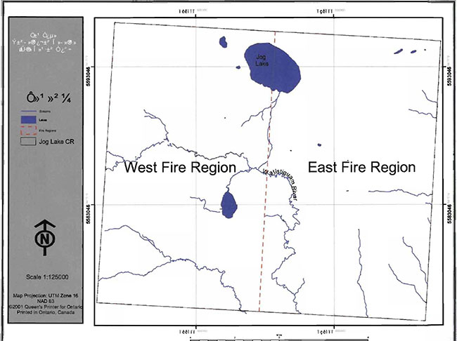
The Jog Lake Conservation Reserve falls within the fire management zones of Nipigon and Hearst (Section 8.4, Figure 4). The management intent is that the conservation reserve will be managed according to the existing fire management guidelines Figure 4.
All earth and life science features will be protected by defining compatible uses, enforcing regulations (Ont. Reg. 805/94 PLA) and monitoring and mitigating issues. Industrial activities such as; timber harvesting, prospecting, mining, and new hydro generation will not be permitted within the boundaries of the conservation reserve as per Policy 3.03.05. Energy transmission, communication and transportation corridors or resource roads or construction of facilities are discouraged, through existing planning process.
Exceptions based on a Test of Compatibility may be made for minor structures for Inventory Monitoring and Assessment Reporting (IMAR) or scientific research (see section 6.4).
The introduction of exotic and/or invasive species will not be permitted. Programs may be developed to control forest insects and diseases in the conservation reserve where these threaten significant heritage, aesthetic, or economic values. Where control is desirable and possible, it will be directed as narrowly as possible to the specific insect or disease. Biological control will be used wherever possible.
The collection/removal of vegetation and parts thereof will not be permitted. However, subject to a Test of Compatibility, the Area Supervisor may authorize the collection of plants and/or parts for the purposes of rehabilitating degraded sites within the reserve if required and for research or scientific study.
Additional life and earth science inventories should be completed that include ground visits at Jog Lake, along the major rivers and at the unknown lake and associated hill landform if possible. Ratification of moraine formations ascsociated with the latter unknown lake and landform is warranted. Additional wetland classification using modern technologies (i.e. satellite imagery, aerial photographs, or other remote sensing technologies) or future classification systems (Ecological Land Classification (ELC)) should be considered.
MNR will provide leadership and direction for maintaining the integrity of this site as a natural heritage estate. Research, protection education and understanding and interpretation of the natural heritage features of the site will be encouraged and fostered through local and regional natural heritage programs and initiatives.
Fish and wildlife:
Fish and wildlife resources will continue to be managed in accordance with policies and regulations prevailing in the area and under the direction of the Area Supervisor. Provincial legislation and policies will dictate management and enforcement objectives for this conservation reserve.
Existing trapping, hunting and sport fishing will be permitted by outfitters and the general public. Access by snowmobile and aircraft are still permitted. First Nation treaty rights will be respected (see Aboriginal Interest, Section 6.2). No new commercial outfitting, outpost, hunting camps or new trap cabins will be permitted within the boundaries of the conservation reserve.
Cultural heritage:
At present, there is no need to survey cultural resource, since there is probably a low potential for cultural resources and since any such resources are in no danger of being affected by existing use.
Land use /existing development:
Land disposition and the construction of commercial facilities or road access will not be permitted as per policy PL 3.03.05, since no facilities or road access within the conservation reserve exist presently (see Commercial Use Management Strategies below).
The north-south Niven survey line and the 7th Baseline that were originally cut early in the last century will continue to be allowed to be rehabilitated naturally.
Commercial use/tourism and recreation:
Current level of commercial fly-in hunting and trapping will be allowed to continue. However, no new commercial outfitting camps or activities, including Bear Management Areas (BMAs) will be allowed as per policy PL 3.03.05.
Jog Lake Conservation Reserve is not considered suitable for commercial fishery or bait fish operations- so no new commercial fishing operations will be allowed within this protected area.
Currently, no recreational/interpretive facilities exist within the conservation reserve. Future recreational developments such as campsites, privies or access points including boardwalks, trails or aircraft landing sites will not be considered until a Test of Compatibility is conducted.
Finally, Jog Lake Conservation Reserve will not be considered as a wild rice planting or potential harvesting area due to its current wetland resources and isolation.
Aboriginal interests:
There are several First Nation communities within the vacinity of the Jog Lake CR. Constance Lake First Nation and Long Lake 58 First Nation are located within range of the boundaries. Information indicates that Ginoogaming First Nation and Aroland First Nation interests tend to be slightly beyond the boundaries.
Aboriginal and treaty rights will be recognized.
Client services:
Under the direction of the Area Supervisor, Hearst District natural heritage staff will respond to public, non-government organizations (NGOs), industry and MNR partner requests for basic information on the site. Such requests could include but are not limited to the following; regulated boundaries, values, current access and infrastructure, permitted uses, role that Jog Lake Conservation Reserve plays as a natural heritage estate and within the greater provincial parks and protected area system and any additional information that is required to meet good customer service.
6.3 Specific feature/ area/ zone
Natural Heritage Stewardship:
Natural heritage stewardship will deal with site speci·fic management concerning the deciduous forest associated with the hill northeast of the unnamed lake, the vegetative communities - especially the large open fen areas that extend across the site’s boundary into the proposed ANSI to the north as Well as the need in the future for management zones.
a) Deciduous forest community:
Little is known about this vegetative community which is unique to the conservation reserve and possibly this portion of the OHBL in general. Further life and earth science work is warranted for this area within the conservation reserve. The vast amount of wetland within Jog Lake Conservation Reserve makes this hill and vegetative community possibly susceptible to an access point (e.g. campsite or helicopter access point) for future inventory or research programs.
To protect this community the following will be encouraged:
- This community and its earth science features should be further studied to determine its significance. The community will be disturbed as little as possible to ensure its integrity and long term protection;
- If any portion of the community has to be disturbed to allow for inventory, research or recreation to take place it will undergo a Test of Compatibility to determine if such a proposal is warranted;
- Any future proposal that is entertained by the MNR and that could reduce the quality of the representation associated with the hill and its vegetative community or communities will require additional planning that could include public consultation.
b) Open fen communities and regulated boundary configurations:
Jog Lake Conservation Reserve presently captures few of the initial open fen vegetative communities that straddle and occur beyond the northern regulated straight-line boundary. Currently this is not a significant problem, since the conservation reserve lies within the OHBL and within a landscape that is not being developed by industry. However, if industrial development approaches this and the other straight-line boundaries of the site, MNR’s ability to protect these wetlands from associated land use will become more difficult. To address these issues the following strategies will be conducted if the need arises:
- District Office to assess the wetland vegetative communities with respect to the site’s ecological considerations that include, size, shape, limit of wetland core areas and sensitivities of communities within the conservation reserve or their abilities to buffer adjacent land use. Such an analysis will help to determine what additional considerations will need to occur if industrial development approached the site’s regulated straight-line boundary;
- MNR to work with industrial community to resolve boundary issues and ensure that the wetlands represented within the current conservation reserve are protected.
c) Management zones:
If, during the course of data collection it is deemed necessary to regulate access or uses in certain areas, management zones may be developed. These zones will facilitate permitted/restricted activities for the protection of certain features or to resolve conflicts between uses. The creation of management zones will require additional planning beyond this SCI, public consultation and eventual plan amendment if accepted.
6.4 Promote Inventory, Monitoring and Assessment Reporting (IMAR), and research
The natural state of Jog Lake Conservation Reserve and the biological process that occur in this old growth landscape support the site as a possible regional, provincial or global benchmark- especially in terms of old growth, wetland and peat communities, climate and other parameters. However the lack of road access limits the site’s capabilities.
Scientific research by qualified individuals, which contributes to the knowledge of natural and cultural history and to environmental and recreational management, will be encouraged. Research related to the study of natural processes will also be encouraged provided it does not harm the values of the reserve. All research programs will require the approval of the Ministry of Natural Resources and will be subject to ministry policy and other legislation. Those interested in pursuing research within the conservation reserve must apply to the Area Supervisor for approval. Applications to complete the research will follow guidelines established by Ontario Parks for research within provincial parks (see Appendix 9.6, Procedural Guidelines C - Research Activities in Conservation Reserves from PL 3.03.05) or equivalent direction formulated by the Hearst District. Approvals will meet all terms and conditions established by the MNR Hearst District Office.
Additional life and earth science inventories are required to refine values and management guidelines. These are considered to be a priority. At this present time, further cultural inventory and assessment is not required.
The ministry may approve on a case by case basis the removal of any natural or cultural specimen by a qualified researcher. All such materials removed remain the property of the Ministry of Natural Resources.
Long term monitoring and assessment may occur, however at the present time road access to the site limits long-term sample plot development. However, future permanent plots or observation stations may be established to which researchers can return over time. Any long term sampling plot design and implementation will require MNR, Area Supervisor approval.
New research developments such as campsites, privies, trails or developed access points will not be considered until a Test of Compatibility is conducted. The Test of Compatibility or environmental screening process could include a review of the demand for structures or may require more detailed life or earth science or cultural information and possibly a more detailed management plan.
6.5 Implementation and plan review strategies:
Implementation of this SCI will primarily involve monitoring activities to ensure adherence to the management guidelines. Other activities will include funding future life and earth science inventories, preparing a fact sheet highlighting the important natural heritage values of the reserve and responding to inquiries about the site.
Implementation of the SCI and management of the reserve are the responsibility of the Area Supervisor. Partnership may be pursued to address management needs. Jog Lake Conservation Reserve SCI will be reviewed on an ongoing basis. If changes in management direction are needed at any time, the significance of the changes will be evaluated. Minor changes, which do not alter the overall protection objectives, may be considered and approved by the Area Supervisor without further public consultation and the plan will be amended accordingly. In assessing major changes, the need for a more detailed Resource Management Plan will first be considered. Where a management plan is not considered necessary or feasible, a major amendment may be considered with public consultation. The Regional Director will approve major amendments.
This SCI or future RMP, if required, plus the Land Use Atlas and associated website will be amended to reflect any changes in management direction.
6.6 Marketing strategies
Jog Lake CR will be marketed as a distinctive natural area having significant life science values. In this regard, a fact sheet may be prepared to inform the public about these values and their role within the greater parks and protected area system and current access. Marketing efforts to increase use are not a priority at this time and will be kept to a minimum.
7.0 References
Bostock, H.S. 1970. Physiographic subdivisions of Canada; in Geology and Economic Minerals of Canada, Geological Survey of Canada, Economic Geology Report no. 1:11-30.
Grins, W.J. and Peter W.C. Uhlig. 2000. Ecoregions of Ontario: Modifications to Angus Hills' Site Regions and Districts. Revisions and Rationale. 7pp and map.
Harris, A.G., et. al. 1996. Filed Guide to the wetland ecosystem classification for northwestern Ontario. Ont. Min. Natur. Resour., Northwest Sci & Technol. Thrunder Bay, Ont. Field Guide FG-01. 74 pp. + Appendices
Hills, G.A. 1959. A ready reference to the description of the land of Ontario and its productivity: Division of Research Ontario Department of Lands and Forests. Maple, Ont. A-4.
Kor, Phil., Personal interview by John E. Thompson, 2001.
OFRI. 1994. Keep It Wild Jog Lake Landforms - map.
Ontario. Minsitry of Natural Resources. 1981. Hudson Bay Lowland: Nature Reserve Life Science Check-sheet for Jog Lake.
Ontario. Ministry of Natural Resources. 1985. Moosonee District: Background Information. 60-63.
Ontario. Ministry of Natural Resources. 1995. Geology and Principal Minerals of Ontario- map. Ontario, Canada, Queen’s Printer for Ontario.
Ontario. Ministry of Natural Resources. 1981. Canoe Routes of Ontario. The definitive guide to more than 100 canoe routes throughout the province. Parks and Recreational Areas Branch in cooperation with McClelland and Stewart. Toronto, Ontario. The Canadian Publishers.
Ontario. Ministry of Natural Resources. 1988. Statement of Interest for Jog Lake. Area of Natural and Scientific Interest.
Ontario. Ministry of Natural Resources. 1994. Research Activities in Provincial Parks, PM 2.45.
Ontario. Ministry of Natural Resources. 1997. Regulation to Amend Ontario Regulation 805/94 Made Under the Public Lands Act.
Ontario. Minsitry of Natural Resources. 1983. Hearst District Land Use Guidelines.
Ontario. Ministry of Natural Resources. 1993. Ontario’s Naturai Heritage. Endangered Spaces Candidate Area Report.
Poer, Scott. 1992. Report on the Status of Provincial Parks in the Site Regions and Districts of Ontario - Draft Report.
Riley, J.L. 1981. Candidate Life Science Nature Reserves for Ontario’s Hudson Bay Lowlands.
Rowe, J.S. 1972. Forest Regions of Canada. 20 pp.
8.0 Maps
8.1 Figure 1: Jog Lake Conservation Reserve map
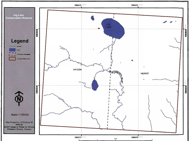
Enlarge 8.1 Figure 1: Jog Lake Conservation Reserve
8.2 Figure 2: Jog Lake Conservation Reserve location map
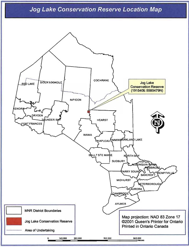
Enlarge 8.2 Figure 2: Jog Lake Conservation Reserve Location Map
8.3 Figure 3: Jog Lake Conservation Reserve vegetation map
8.4 Figure 4: Jog Lake fire region map
9.0 Appendicies
9.1 Life science check sheets and associated documentation
- Candidate Life Science Nature Reserves for Ontario’s Hudson Bay Lowlands, J.L. Riley, March 1981, MNR Parks and Recreation.
Hudson Bay Lowland- Nature reserve life science checksheet
Riley 1981b
- Name: Jog Lake
- Map Name: Kenogami River
- Map Number: 42K
- UTM Reference: 16UFL2085
- County, District: Cochrane
- Latitude: 50°24′ N
- Longitude: 85°20′ W
- Altitude Minimum: 600′
- Altitude Maximum: 725′
- Township: N.A.
- Ownership: Crown
- Area: 124800 acres 560500 ha
- Forest Region District: B.5
- Site Region and District: 2E.l
Aerials photographs
| Year | Roll | Flight Line | Numbers |
|---|---|---|---|
| N/A | N/A | A15090 A14060 |
137-140 59-63 |
Physical and Biological Features
Significance
Provincial. Unusually large, raised peatland complex, with radial patterning centred on a raised, peat-margined lake.
Resource conflicts
Mining claims by Selco Mining may still be outstanding in the immediate area; conflict indeterminate.
Recommended Management
[No information provided]
Data sheets included
- Vegetation Map
- Bibliography
Major information sources
[No information provided]
Evaluation and priorities
1st priority candidate; critical.
Jog Lake Information Sources
- I.B.P. site, Co. 1.
- McEwan 1964 (vegetation mapping at 1: 1000000).
- O.C.R.S. reconnaissance; II, 12 July 1979.
- Saprling 1973.
- Riley (in prep.).
9.2 Earth science check sheets and associated documentation
Jog Lake ANSI fact sheet
Location and significance:
The lake ANSI is located in unsurveyed territory and is situated equally divided between the territorial districts of Cochrane and Thunder Bay along the line of 85.20 west longitude, approximately 180 km north of highway 11 in the Hearst district. The 50,500 hectare site is a provincially significant raised peatland and wetland complex that is in pristine condition and of great scientific value related to a number of the vegetative complexes and habitats of the Hudson and James Bay lowlands.
National topographic map series: 42K
Scale: 1:250,000
UTM 16UFL2085
Bedrock geology:
The Archaen (crystalline rocks) aged bedrock is deeply overburdened in much of the Lowlands by younger sedimentary deposits that sometimes exceed 800 meters in depth. In the Jog Lake mea the sediments are related to the Palaeozoic era and were laid down some 400 million years ago. This period was termed the mid-silurian and is characterized by dolostone, limestone, sandstone and shale deposits formed from marine sediments of ancient seabeds.
Very little is known of the archaen formations below the sedimentary bedrock in this area. The true mineral potential of this ANSI is generally considered unexplored. Very little information has been gathered and little can be verified without actually sinking drill holes to sample the basement strata. Airborne electromagnetic surveys have indicated the presence of a potential mineralized zone stretching across the southerly portions of the ANSI in an east-west direction. Part ofthis area just to the West ofthe ANSI was staked, investigated and abandoned without any measure of success in finding sufficient minerals. Records of this block of 20 cancelled claims are available through the Mining recorders office in Thunder Bay.
Surfical features:
With the passing of the last ice age and the final retreat of the Wisconsian age the glaciers that covered this area date back about 8,000 years ago when the lowlands were invaded from the north by seawaters. The Tyrell Sea, an expansion of the present Hudson and James Bay covered the lowlands and slowly receded as the lands rebounded from the weight of the glacial ice. This left a wide flat seabed plain composed mainly of lacustrine deposited clays and silts. Gradually deep peat and organic overburdens resulting from accumulated vegetative build-up occurred and primitive drainage systems began to develop.
Primitive drainage remains in place in much of the area. Jog Lake is the high point in the area. A conical drainage pattern occurs but mainly through a subsurface seepage in all directions through the peat soils. The contour lines tend to circle Jog Lake for many kilometres out from the lake. One small surface overflow stream drains Jog Lake to the South falling only a meter in the first 1.5 kilometres. This stream continues on to meet with a number of easterly and north-easterly flowing streams that cross the peatlands within narrow elevation ranges eventually joining major tributaries of the Kenogami (Albany River) drainage.
One theory on the formation of Jog Lake indicated that it was a very sudden happening probably cause by a large meteorite striking the earth from a low angle of about 20 degrees. This impact caused the massive disintegration of the object into many smaller parts, many of which shotgunned outward in a south-westerly direction from the main impact point at Jog Lake along with huge amount of displaced surfical lacustrine and organic deposits. The main body of materials passed through the softer clay and silt overburdens and well into the paleozic rocks. At the same time, the impact forced a slight rise in the immediate area surrounding the crater of the newly formed Jog Lake. This was caused from the influx and compaction of materials at the craters and outwards and the plasticity of the newly rebounding seabed. Indications of the force of the impact are found to the southwest where much of the displaced material came to rest.
The Jog Lake area gently slopes outwards in all directions from the lake that is the area high point at 628 ft (191 m) about sea level. The 625 ft (190 m) contour lies close to an average distance of6 kms out from the circling Jog Lake. The 600 ft (183 m) contour lies about 12 km average distance out from Jog Lake indicating a very gentle, almost flat outwardly sloping plain from the lake. South of the Watistiguam River and approximately 8 km to the southwest of Jog Lake lies Biggar Mountain which towers up to 725 ft. (221 m.) above sea level. This is a major irregularity in this area is believed to have been created after the recession of the Tyrell Sea. There is a belt 9 km long and 2 km wide of randomly scattered deposits that lie west of Biggar Mountain that rise up to 20 ft (6 m) above the surrounding peatlands. These deposits are believed to be remnant material from the meteorite and airborne locally displaced material from the Jog Lake crater impact, which probably occurred 2000 years ago.
Lake Biggar lies in the shadow of Biggar Mountain and is believed to have been created at the same time as Jog Lake either from second meteor or more likely a large fragment of the Jog Lake meteor. It is believed that Biggar Mountain is part of the fragment that remains above ground towering over the gently sloped peatlands. Just to the north of the Mundio River, a second small parallel belt of randomly scattered raised deposits, believed displaced from one of the lake craters, lies in an east-west orientation some 14 km to the south-west of Jog Lake, and about 3 km from Lac Biggar. These airborne deposits are much smaller than the northerly group and it is proposed that they were displaced from the secondary Lake Biggar impact point. This is explained due to their proximity and alignment to that crater, their smaller average and uniform size suggests a less severe contact and the obvious lack of deposits lying between the two belts.
The parallel lineament of the two deposit belts (about 5 km apart south-west of Jog Lake) may well be the reason for the magnetic band indicated on aeromagnetic mineral surveys in this area and to the south of Jog Lake. These reading may be created due to mineralization of broken meteorite fragmentation deposits aione or a magnetic field created by the opposing lines of deposits.
At such time as a detailed study of the Jog Lake area can be undertaken, there would be immense value in coring many of the lower deposits and even drilling Biggar Mountain to further evaluate the origin of these unusual formations. The earth science features of this site may well be of more significance than previously considered.
All of the above features can readily be identified on the Jog Lake map sheet 42K/6, Canada map series, scale 1:50,000.
A second theory resulting from the conical drainage pattern of the Jog Lake area is that Jog Lake is actually a volcanic pipe. The volcano being very ancient and very large was overburdened with paleozoic and lacustrine deposits over millions of years and only the top of the cone is visible. There are no signs of volcanic bedrock at or near the edges of the lake and this theory is most unlikely to be true.
The third possibility of the area origin is that a large recessional moraine or ice crevasse ridge located to the south of the Watistiguam River was later covered by the waters of the Tyrell Sea. The wave action washed the finer grained sands and gravel of the till materials and eroded the moraine to a few low plateau-like formations with the exception of Biggar Mountain. This remaining outcrop on the flat peat was actually a large kame formation that rose above the old seawaters and was of such a size that it was not fully eroded prior the waters of the Tyrell Sea receding. Deep peatland formations have since formed over the entire area hiding the remains of heavier broken rock and boulder beds remaining from the eroded glacial tills of the moraine This is the best alternative theory of the formation of the raised contour areas but does not address the formation of Jog Lake, a very large and raised circular lake in a broad lake-scarce landscape.
Only the drilling of the rim area of Jog Lake, Biggar Mountain and other related outcrops can verify the true earth science history of this area and which theory or combination of theories are correct.
Vegetation:
Early vegetation reconnaissance mapping at a scale of 2 inches= 1 mile (1:126,720) was completed for the Jog Lake ANSI in 1981 by J. Riley working from mapping by McEwan, 1964@ 1:1,000,000 scale and information from other sources (O.R.C.S., 1979; Sparling, 1973).
This mapping identified up to nine broad vegetative landscape complexes within the ANSI catagorized as mainly treed bogs or open, graminoid, and lowbush fens and bogs.
Some conifer swamps were present in the better-drained locations primarily in narrow belts around lakeshores and liner drainages.
Most unusual is the presence of a small deciduous swamp atop Biggar Mountain to the south of Jog Lake. This vegetative grouping is quite rare in this area and may host a number of rare species of plants and plant communities. As well, the site may be a potential host habitat to a number ofraptors, some of which may be quite rare in Ontario.
It is essential that this site should be visited as early as possible and inventoried for life science values before the site being cleared to accommodate a helicopter land site for exploration drilling. This outcrop will no doubt be a prime drill target in future investigations ofthe magnetic anomaly readings present across the southerly portions of the ANSI. It would appear that a floatplane could land close to the base of the mountain. A suitably detailed reconnaissance inventory of the deciduous swamp forest as well as the adjacent landscapes could be carried out from a central camp in just a few days. A small mammal trapping program, bird nesting and herpetile viewing could be accommodated in a spring time survey of the site. A similar camp located on Jog Lake could effectively inventory the remaining vegetative landscapes and lowland habitats.
Disturbances:
The Jog Lake vegetative complex is essentially in pristine condition with a minimal amount of disturbance to the earth and life science values. Only a few irregular aircraft landings are believed to occur from time to time on the two main lakes.
The area is not known to be utilized for tourism purposes being limited in scope to wetland habitats and rather uninteresting for traditional northern tourism activities. Fishing, hunting, and viewing are not spectacular, seasons are short, weather harsh an access limited and expensive.
Inland, the vegetative landscape remains untouched with the excerption of the east-west cutting survey of the 7th baseline and the north-south survey line along 85.20 degrees west longitude. These lines were established over a number of years in a period of the tum of the century and have not been retraced since those times.
No roads exist close to the Jog Lake ANSI, those closest being only of low quality and extending southerly from Pagwa River on the CNR northern line to Highway 11. The slope of the lands create a large number of wide river crossings and the lack of suitable road construction aggregates offer major obstacles to any all-weather road access developments to the north of Pagwa River. The decline of merchantable timber growth on the lowlands also precludes investment in winter road access for forestry operations.
Only the mining industry could have sufficient reason at some future time to consider pushing access to the north and, if so, the roads would most likely be restricted to winter travel. Should the necessity of winter road construction occur, it should be aligned with the existing north-south and east-west survey lines that are presently established within the ANSI. Widening the lines and establishing short feeder trails as necessary across the more stable landscapes should lessen impacts to existing values.
First Nations, Aboriginal values:
The Jog Lake ANSI is located on the outside edge of two and possibly three traditional hunting and trapping areas. The Calstock (English River), Long Lake and Martin Falls First Nations may have at some time wandered onto Jog Lake or some of the larger streams within the ANSI during winter hunting and trapping trips. There are no identified aboriginal campsites or other indications of any extensive time spent within the ANSI. It may be that the lake and area was not known prior to being intersected by survey crews in the early 1900’s. This due to the lack of direct navigable waterways and vast stretches of wetlands separating the ANSI from any of the traditional gathering places of those bands that, in the past, travelled the area.
Human intervention:
Discounting the possibility of Hudson Bay Company employees engaged in the fur trade (near Mammamattawa House established in 1796 near the junction of the Nagagami and Kenogami Rivers), the first recorded intervention by man into the Jog Lake area occurred in 1870 when Robert Bell, a geologist employed by the government, explored the Kenogami River from its headwaters to James Bay looking for minerals and potential settlement lands. Bell’s trip took him close to the southern limits of the Jog Lake ANSI and he may have made a side trip up some of the smaller streams into the southern section of this area (Mindino and Watistiguam Rivers). In all likelihood, his reconnaissance survey would not have taken him any great distance off the waterways.
Following Robert Bell, the next major intervention was the cutting and survey of the boundary line between the then territorial districts of Algoma and Port Arthur (now Cochrane and Thunder Bay). This line was surveyed by Niven in 1907 and 1908 - northward from Lake Superior beyond the Grand Trunk Pacific proposed right of way (CNR north line) almost to the Albany River, the northern limits of Ontario at that time. Nivens survey runs along the meridian line 82 degrees, 20 minutes, west longitude. This line passes through the center of Jog Lake and the ANSI.
The north-south survey by Niven was later followed by the survey and cutting of the 7th baseline. This survey stretched across Ontario from Manitoba to Quebec following much of the northerly limits of the Province as set out in 1881. The 7th baseline was cut and surveyed by several different parties over a number ofyears. That portion ofthe 7th baseline on either side of the Nevins meridian survey of 1907-08 was surveyed under the direction of O.L.S. F.W. Beatty in 1929. Narration relates that separate field parties proceeding eastwards from the Nakina area were to meet up with westerly bound cutters at the north-south territorial boundary line at or near a point that ran through a large circular lake. The party from the west arrived first in late October. Due to an early freeze, and after one small mishap, they were able to establish a cairn tie on the ice in the center of the lake where the 7th baseline intersected the meridian 82.20 west longitude. They were then able to establish camp on the south shore of the lake on the territorial boundary line to await the arrival of the cutters from the east. Two members of that group in addition to F.W. Beatty that are worthy of mention were D.P. Paleczny, a new immigrant to Canada, and Angus Biggar, recently returning to Ontario after establishing a small farming community in northern Saskatchewan. Both of these men were down on their luck due to the stock market crash of 1929 and were hired onto a survey party in Port Arthur. They both were soon trusted lead cutters, blazing trail eastward and scouting the way ahead for the main field party. The large round unnamed lake was thought to be dubbed Paleczny Lake in the field notes of the westerly survey group in honour of the first man to reach it, D.P. Paleczny, who was later sent out to test the ice thickness and did not return. Later, in the same month, it was Angus Biggar, while walking south on Nivens line, who noted and explored the highpoint, termed Biggar Mountain. From this viewing place, it is said he and members of the party were able to observe Paleczny Lake in the distance across the open flat wet lands. This was where the camp smoke from the easterly party that had reached the territorial boundary line well to the north of Paleczny Lake was first thought to be observed. Once the field parties linked up it was noted that a jog of some 10 kilometres was evident on the 7th baseline at the points of intersection with the Nivens Meridian line. After great deliberation, it was suggested that it was no one’s fault and that it was unlikely that anyone would notice for quite some time. Field notes suggest the final point that was resolved was that the name of Paleczny Lake was changed to Jog Lake to better reflect the actual field conditions of the survey. It was believed that no one could pronounce Paleczny anyhow.
The combined field party then probably secured a large amount of hardwood saplings from the crest of Biggar Mountain, the only source of hardwood for many miles around, and making snowshoes for each man, prepared to walk out. After trekking out to the Grand Trunk Pacific R.R. (CNR north line), some cutters decided to return home and others wintered near Pagwa working in the track-side pulpwood camps.
Angus Biggar left and taking his earnings is reported to have invested in flying lessons, becoming a bush pilot, flying survey crews and prospectors into the Red Lake area during the gold mining boom through the 1930’s. He was believed lost in 1940 during the height of action in the Battle of Britain when he supposedly died a hero saving his Spitfire squadron over the English Channel.
Tourism:
The Jog Lake area is reported to have been looked at as a potential wilderness outpost camp location by different groups over the years. No official licensed camps have located on the lake. It is believed that parties have flown into the lake in the past to try hunting and fishing with the idea of establishing a permanent base but found both the site and resources unsuited to investment. It is unlikely that tourism will ever play any form of a major role in this area.
Trapping:
Jog Lake does have some trapping resources but is difficult to work except in the dead of winter when the lowlands are frozen. Waters on Jog Lake are very rough during storms or even light winds and water travel to check traps is not reliable. Access to the site is expensive by aircraft. Better trapping conditions are available on the river systems to the south and north of the ANSI where access may be obtained by direct boast travel from existing communities, roads or rail lines. The ANSI is unlikely to ever become a high use trap line area although it now forms part of a number of existing traplines.
Other development:
Other than mining related, there are not other developments that are forecast to occur at this remote location.
Boundaries:
The ANSI boundaries should be slightly expanded o the fall between 85:10 North latitude from the present boundaries. The boundary relates to existing 1:50,000 mapping on three sides and is far easier to determine on smaller map scales more commonly used in the lowlands. The new proposed boundaries also incorporate the majority of the raised plateau-like ground formations near the westerly and southerly boundaries.
9.3 Recreational check sheets and associated documentation
- None on file
9.4 SCI amendments
- None on file
9.5 SCI Test of Compatibility
- Taken from the SCI Test of Compatibility NER Guideline in Planning process for Conservation Reserves Statement of Conservation Interest (SCI) and Resource Management Plans (RMP) Northeast Region Guidelines Version 2.1 September 17, 2001, Appendix 4, page 44.
SCI Test of Compatibility
NER guidelines
- Conformity to SCI - This is not applicable to evaluating current or new uses that come forward during the SCI planning process. However, the SCI should include a statement that speaks to the required screening of any future use or uses that are not covered in the current SCI.
-
Screening Process- proposed uses for the area must be assessed before they are approved. To establish a minimum standard, NER recommended that the Screening Process identified in Section 4.2 of A Class EA for Provincial Parks and Conservation Reserves Phase IIB: Draft Class EA (subject to approval by MOE) be used to screen projects and options.
The Screening Criteria from the draft Class EA (Table 4.1) are further details below within the context of SCI planning.
-
Impact Assessment-The Test of Compatibility from the Conservation Reserve (CR) Policy PL 3.03.05 identifies the classes of values and main concepts that need to be considered in determining the impacts of uses on a specific CR.
These include:
- Natural Heritage
- Cultural
- Research activities
- Current uses
- Area administration
- Accommodating the use outside the CR
- Socio-economics
- Area accessibility
The Class EA (Table 4.1) presents similar values and concepts under the following considerations:
- Natural environment
- Land use, resource management
- Social, cultural and economic
- Aboriginal
The above considerations and classes of values are meant to assist planning staff in answering the following questions for any potential use:
- Will the new use impact any values within the CR?
- If so how?
- To what degree?
- It is tolerable?
The new screening process and associated criteria identified in Table 4.1 of the draft Class EA give planning staff more direction than the CR policy 3.03.05. However, this section attempts to assist planning staff by providing some direction for further interpreting the criteria to complete a Test of Compatibility for uses within a CR,
The following information for each CR is available and can be use Do asses the required criteria:
- Background information and current inventory data;
- Current inventory evaluations (e.g. earth, life and recreational check-sheets); and
- Future ongoing analysis on the site.
Background information files, summaries and other data can be beneficial in determining additional criteria that could be added to address criteria already mentions in the EA screening process. Criteria that are linked to habitat needs for specific life or earth science features are often first recorded during a District’s initial review of a site. Databases such as NRVIS or documents such as Lake Survey files, Site District Reports or Forest Management Plans can identify the location of values and sometimes determine a value’s significance or sensitivities.
Current inventory evaluations:
The most current state of the resource for a specific OLL CR will be the earth, life and recreational check sheet. These documents determine the current earth and life science values, their present state and their significance. The recreational check-sheets determine current recreational features and current and potential recreational activities and feature significance and sensitivity to present and future uses.
For earth and life science check-sheets, five (5) major sections are completed that include; representation and the quality of the representation (e.g. based on condition, diversity and ecological considerations) and special features. There are five categories that are reflected within the screening criteria presented in the draft Class EA document or could be used to develop additional criteria. The five categories are listed below:
- Representation
- Condition
- Diversity
- Ecological Considerations
- Special Features
9.6 Procedural guideline C - Research activities in Conservation Reserves from Policy 3.03.05
- Compiled by - Branch: Lands & Natural Heritage
- Section: Natural Heritage
- Date Issued: February 11, 1997
1.0 Definitions
In this policy,
- "Conservation Reserve" means a class of zone established by O. Reg. 805/94, made under authority of section 4 of the Public Lands Act (see Appendix "A);
- "designated" means having been formally identified as an area of public lands to be a Conservation Reserve, by incorporation under O. Reg. 805/94;
- "land use occupational authority" includes a lease, licence of occupation, land use permit, beach management agreement, or easement, and excludes a work permit,
2.0 Introduction
This policy provides direction for establishing, planning and managing conservation reserves. Guidelines are provided in Procedure PL 3.03.05 (Conservation Reserves) to help in applying the policy to individual conservation reserves.
Ontario’s network of natural heritage areas has been established to protect and conserve areas representative of the diversity of the natural regions of the province, including species, habitats, features and ecological systems which comprise that natural diversity. Protected natural heritage areas are a key component in sustainable management of natural resources. They ensure that representative sites within the larger sustainably managed landscape are permanently retained in their natural state.
These areas are considered to be sensitive, requiring protection from incompatible activities if their values are to endure over time. The Ministry of Natural Resources has established conservation reserves as a new tool to offer protection for natural heritage areas on public lands, while permitting many traditional public land uses to continue. Such uses include the traditional activities of Aboriginal peoples.
Protection means legal, permanent exclusion of industrial resource extraction activities, specifically: mining, commercial forest harvest and hydro-electric power development. Two tools for protecting natural heritage values currently exist under provincial legislation.
- Provincial Parks, which have in the past been the principal means to protect Ontario’s significant natural heritage areas, are protected by regulation under the Provincial Parks Act.
- Conservation Reserves, which are protected by regulation under the Public Lands Act and by withdrawal of lands from staking under the Mining Act (the subject of this policy).
Natural heritage values are identified and special management considerations are given through:
- Withdrawals from timber allocations in Forest Management Plans for natural heritage areas on public lands (such as Areas of Natural and Scientific Interest - ANSI). Partial protection from mining and mineral exploration may be provided by withdrawal under the Mining Act.
- Areas of Concern (AOC) on public lands. In land use planning and forest management planning, Area of Concern designations are placed or. identified values for vaiying periods of time.
3.0 Program direction
3.1 Application
This policy will be applied on any public lands where natural heritage values require protection and where Conservation Reserves are seen to offer the best approach to protecting those natural values.
3.2 Goal
The goal of Conservation Reserves is to protect natural heritage values on public lands while permitting compatible land use activities.
3.3 Objectives and strategies
- To identify Conservation Reserves through a science process.
All natural heritage areas, including potential conservation reserves, are identified through a science based inventory, evaluation and selection process. The ministry has two methodologies to determine natural heritage representation requirements;
- A Framework for the Conservation of Ontario’s Earth Science Features
- A Framework for the Conservation of Ontario’s Biological Heritage
Both frameworks describe systematic approaches to inventorying the diversity of the natural landscape, identifying the requirements for representing that diversity, selecting potential candidate areas, and picking the ‘best’ as the preferred candidate area for consideration by the subsequent planning process for long term protection. as part of a permanent natural heritage areas system.
Candidate areas can range from very small, representative samples of the natural diversity (e.g. old growth white pine sites or bedrock exposures) to more extensive areas which provide a cross section of representative landscape diversity.
-
To ensure that potential Conservation Reserves are withdrawn from staking.
Once a candidate natural heritage area is proposed as a conservation reserve, the Ministry is to request that the surface and mining rights for the area be withdrawn from staking, pursuant to section 35 of the Mining Act, in accordance with approved Ministry policy. Consideration is to be given to reopening the surface and mining rights to staking, if the conservation reserve is rejected following land use planning.
Policy Directive PL 3.03.03 (Withdrawal and Reopening of Surface and/or Mining Rights- Section 35, Mining Act) is to be followed for withdrawing lands from staking or allowing the lands to be reopened for staking.
-
To confirm Conservation Reserves through a Ministry land use planning process.
Once preferred candidate areas have been identified, these areas are advanced through a land use planning process. This process identifies all other land uses (e.g. forestry, mining, tourism, recreation, development, etc.) on the same land base and the socio-economic implications of setting aside areas for natural heritage area protection.
Public views are sought on options through a variety of consultation mechanisms. Public advice is considered in making final decisions on which areas are to be finally selected and how they are to be protected.
-
To afford Conservation Reserves legal protection.
Once a Conservation Reserve is confirmed through a land use planning process, it will be added to the Schedule under O. Reg. 805/94 made under the Public Lands Act.
-
To manage Conservation Reserves to protect the integrity of their natural values.
Conservation Reserves will be managed in accordance with section 4.0.
4.0 Management of Conservation Reserves
Conservation Reserves will be managed in accordance with this policy and appropriate restrictions determined through Statements of Conservation Interest or Resource Management Plans.
Management of a Conservation Reserve is the responsibility of the Ministry of Natural Resources field organization at the District level. Management includes initiation of regulation under the Public Lands Act, provision of public information, stewardship and area security as a minimum. It also includes authorization and setting of conditions on permitted uses and ongoing monitoring of compliance with approved plan direction.
4.1 Regulation of Conservation Reserves
Once an area has been confirmed as a Conservation Reserve through the land use planning process, Area Supervisors will notify the District Manager, Regional Director, and Director, Lands and Natural Heritage Branch. The Natural Heritage Section, Lands and Natural Heritage Branch, will work with regional staff to facilitate: preparation of a reference map and area description, with the Office of the Surveyor General; and, development of a draft amendment to the schedules under O. Reg. 805/94 of the Public Lands Act with Legal Services Branch. Lands and Natural Heritage Branch will be responsible to move the proposal forward to Regulations Committee after the Regional Director has approved the area description and plan provided by the Surveyor General.
4.2 Statements of Conservation Interest /Resource Management Plans
The management and administration of each Conservation Reserve will be guided by either:
- an approved Statement of Conservation Interest or,
- if deemed necessary as a result of the need to resolve complex issues, a Resource Management Plan.
These statements/plans will consider public consultation held prior to regulation of an area as a Conservation Reserve. They will identify permitted and restricted uses. New uses will be considered through amendments to these statements/plans based on a test of compatibility.
Statement of Conservation Interest (SCI) - A statement of Conservation Interest is the minimum level of direction for a Conservation Reserve. It will identify the purpose for which a Conservation Reserve has been proposed and outline the Ministry’s management intent for the Conservation Reserve.
Resource Management Plan (RMP) - For a Conservation Reserve with complex issues, a comprehensive resource management plan may be required. A resource management plan may require additional steps, including additional background information, management options, a draft plan and a final plan.
Area Supervisors are to ensure that a SCI is completed within 3 years of regulation.
Statements of Conservation Interest and Resource Management Plans will be prepared following Ministry planning guidelines with appropriate consultation. See Guideline A - Resource Management Planning in Procedure PL 3.03.05 (Conservation Reserves).
4.3 Forest fire protection
Forest fire protection will be carried out on a Conservation Reserve as on surrounding public lands, unless alternative direction for the control of fire, or the use of fire for management purposes is approved through a Statement of Conservation Interest or a Resource Management Plan.
4.4 Insects and disease
Control of insects and diseases may need to be addressed separately for each Conservation Reserve, depending on the nature of the resources or features being protected, and the nature of the management problem.
4.5 Wildlife management
Wildlife population management, including the management of nuisance animal activity, may need to be addressed separately for each Conservation Reserve, depending on the nature of the resources or features being protected, and the nature of the management problem.
4.6 Permitted activities
(See Guideline B-Land Uses- Test of Compatibility in Procedure PL 3.03.05)
4.6.1 Recreational activities
Most recreational activities that have traditionally been enjoyed in an area can continue provided they pose little threat to the natural ecosystems and features protected by the Conservation Reserve. These permitted activities include wildlife viewing, hunting, fishing, walking, snowshoeing, cross country skiing and boating.
Activities such as snowmobiling and the use of all-terrain vehicles will generally be permitted to continue where they do not adversely affect the values being protected.
4.6.2 Commercial activities
Some commercial uses (such as commercial fishing and trapping) may be acceptable if they do not impact the natural heritage values for which the area is established.
4.6.3 Research
Non-destructive research related to the study of natural processes will be encouraged in Conservation Reserves.
4.6.4 Education
Educational activities will be encouraged provided that they are consistent with the protection ofvalues of the reserve.
4.7 Restricted activities
Subject to section 4.8, specific activities which are incompatible with the protection of natural valus are precluded by O. Reg. 805/94. These include industrial uses such as mining, commercial logging, hydro-electric power development, and the extraction of aggregate, peat, or other industrial uses. Other uses may be determined to be incompatible through preparation of a SCI, resource management plan, or by consideration of a ‘Test of Compatibility’.
Area Supervisors will ensure that, in Conservation Reserves:
- commercial forest management activities are terminated through processes established under the Crown Forest Sustainability Act;
- no grants of water power privileges are made under the Public Lands Act;
- industrial uses are not authorized under the Public Lands Act;
- the extraction of peat, soils or other material is not authorized under the Public Lands Act;
- permits are not issued for the extraction of aggregate under the Aggregate Resources Act;
- land will not be sold or leased for private or commercial use;
- new resource access roads within the mandate of MNR are not permitted; and
- new transmission lines (e.g. power or communications), pipelines, highways and road corridors are discouraged, through existing planning processes.
Other activities which do not pass a test of compatibility will be prohibited (Procedure PL 3.03.05 Guideline 2 - Test of Compatibility). Where such uses would otherwise be allowable on public land, signs advising of the prohibition must be prominently posted in accordance with subsection 28 (1) of the Public Lands Act, as needed. The posting of signs would be decided on the basis of the Statement of Conservation Interest or Resource Management Plan.
4.8 Existing uses
Existing uses determined, through a SCI or resource management plan, to be incompatible with protection of natural values, will be phased out in an equitable manner.
Where incompatible uses are currently permitted through land use occupational authority, such uses will be phased out by either:
- cancellation of occupational authority in accordance with the terms and conditions of the authorizing documents; or
- acquisition as funds are available.
4.9 New land disposition
Land within a Conservation Reserve will not be sold or leased. Permitted uses may be authorized by land use occupational authority excluding a sale or lease.
4.10 Infrastructure
Only minimal facilities will be constructed in Conservation Reserves, and only when necessary to ensure conservation of the natural values and to help visitors participate in outdoor activities.
4.11 Boundary identification
There is no stated policy requirement to mark the boundaries of a Conservation Reserve. Local management discretion can be used to determine where boundary marking may be appropriate.
In order for restrictions to be enforceable, signs must be placed in accordance with the Trespass to Property Act or subsection 28 (1) of the Public Lands Act to advise of any restricted recreational activities.
5.0 References
5.1 Legal references
- Public Lands Act, section 4, 28 (1)
- Public Lands Act , O. Reg. 805/94
- Mining Act, subsection 35 (1)
- Trespass to Property Act
5.2 Directive cross references
- PL 3.03.03 (P&P) Withdrawal and Reopenings of Surface and/or Mining Rights Section 35, Mining Act
- PL 3.03.05 (PRO) Conservation Reserves
6.0 Review date
February 1, 2002
Appendix ‘A’
O. Reg. 805/94 means Ontario Regulation 805/94, as amended, made under section 4 of the Public Lands Act. That regulation reads:
The lands described in the Schedules are designated as conservation reserves with the purposes of protecting natural heritage areas and natural features on public land and preserving traditional public land uses including wildlife viewing, hunting, fishing, walking, snowshoeing, cross country skiing and boating.
Land within a conservation reserve shall not be used for mining, commercial forest harvest, hydro-electric power development, the extraction of aggregate and peat or other industrial purposes.
Purpose:
The purpose of this procedure is to provide procedural guidelines for:
- resource management planning;
- the application of the test of compatibility for uses; and
- the approval of research activities within conservation reserves. Users of this procedure should also reference appropriate other policies, procedures and bulletins in undertaking the above tasks.
Procedural guideline A - Resource management planning
1.0 Purpose:
To guide the management of individual conservation reserves, resource management planning will be undertaken for all reserves within three years of approval and regulation under the Public Lands Act. Plans may take one of two forms - statements of conservation interest or resource management plans. They will be approved by the regional director.
2.0 Preparation of Statements of Conservation Interest
2.1. Introduction
A Statement of Conservation Interest (SCI) is the policy document for a conservation reserve. It should identify area values and provide clear direction on management activity and appropriate/compatible land use. In most cases, where there are no complex issues, the SCI will serve as the only planning document that is required to guide the management of the Conservation Reserve into the future.
For conservation reserves with complex planning issues, a Resource Management Plan may be required to provide policy direction for comprehensive long term management. It will be prepared through the MNR planning process which will include public consultation.
There will be instances where a lack of information precludes making some management decisions.
This should be acknowledged in the SCI, along with means to enhance the information, and a timetable for review/revision. SCI should, as a general rule, adopt a cautious approach, recognizing that the planning exercise is based on limited information. Major decisions, particularly those which could be considered permanent or irreversible, should be left to more comprehensive resource management planning.
Where possible, the SCI should identify specific undertakings needed for interim management (e.g. distribution of public information, access control, canoe route maintenance) and set priorities for them. This will assist in integrating such projects/activities into the work planning process. Statements of Conservation Interest will be brief, normally not more than a dozen pages plus maps.
Statements of Conservation Interest may require some level of public consultation. If SCI land use direction does not differ substantively from that which was provided during consultation on area protection, then additional consultation will not be needed. However, with more complex issues, SCI may require broader public discussion (e.g. including Local Citizens' Committees, special interest group meetings, etc.) before being approved.
2.2. Content/format- Statements of Conservation Interest
Each Statement of Conservaton Interest will consist of:
- a cover page
- the Regional Director’s Approval Statement
- a summary of background information
- map(s) indicating the conservation reserve’s boundaries and significant features
- a series of management prescriptiens, including briefbackground and guideline(s).
2.3. Examples of information sources
The following are suggested sources of information for use in preparing a SCI.
- District Land Use Guidelines/Amendments
- Earth Science Inventory Report/Checksheet
- Life Science Inventory Report/Checksheet
- Cultural Resources Inventory maps
- Air photographs
- Tenure maps (various scales)
- Topographic sheets (various scales)
- Forest Resource Inventory Reports
- local surveys/reports on hunting, trapping, fishing
- leasehold agreements, L.U.P.s, Licences of Occupation, patents
- work permit applications, site development plans
- Sustainable Forestry Licences, FMP values mapping
2.4. Background information
This section, in the form of a checksheet, will include reference information on name, site district/region, size of area and regulation date. Then, two subsections will be included - targets and inventory status.
2.4.1 Representation targets
This section will provide a summary of the earth and life science system values and cultural resources represented; and recreational opportunities available/possible.
2.4.2 Inventories
This section will provide an overview of the inventories that have been completed and their level of detail. It may also identify additional inventories that are needed.
2.5. Values to be protected
This section will provide a description of the key natural heritage values, their condition relative to past resource use and management (e.g. forest management, etc.) activities and their sensitivity to future land use and management activities.
2.6. Management guidelines
The following are potential topics which may have to be dealt with in the SCI. For each management concern, briefly indicate the background or existing situation, followed by the management guideline to be followed.
2.6.1 Land Tenure:
- Deals with Crown or public lands, licences of occupation, land use permits, leases, easements; may also address patent lands which are surrounded by, or adjacent to conservation reserve holdings.
- Management guidelines should deal with tenure, agreements, controls and access restrictions; may address potential land acquisition or disposal, if appropriate.
2.6.2 Development
- Describes existing facilities (e.g. roads, campsites, launch ramps, privies, parking lots, waste disposal sites, etc.); where appropriate, this will be supported by mapping.
- Guidelines should deal with the management of existing facilities and any capital projects required to support interim management (e.g. resource protection). Significant capital development projects will not normally be addressed in a SCI.
Provincial policies which guide development (e.g. water hazard management, shoreline development, wetlands) are applicable in conservation reserves as on other Crown land, unless other specific direction is provided in a SCI or management plan.
2.6.3 Recreation activities
- Describes existing recreational uses (e.g. canoeing, hiking, camping, boating, hunting, fishing, etc.) including any recreational uses permitted/encouraged through land use plans.
- Guidelines should deal with the management of recreational activities, and should consider any potential conflicts. Proposals for regulation amendments specific to the conservation reserve should be identified (e.g. camping prohibitions, posted road closures, horsepower restrictions, slot limits, designation of sanctuaries, etc.)
2.6.4 Commercial activities
- Briefly describe any existing/potential commercial uses, or proposed uses in the land use plan. (e.g. lodges/outpost camps, bait fish licences, bear management areas, etc.)
- Guidelines should identify measures required to ensure protection of conservation reserve values. Where possible, criteria for evaluating proposals for expanded or new commercial uses should be included.
2.6.5 Aboriginal interests
- Identify land claims, traditional use areas, or other claims based on treaty or aboriginal rights which may have a bearing on conservation reserve management (e.g. trapping, wild rice harvesting, hunting/fishing)
- Management guidelines should reflect MNR’s position on aboriginal uses and promote management agreements with affected First Nations.
2.6.6 Natural Resource Stewardship
- This category may be sub-divided into a number of items that deal with specific categories of natural resource management (e.g. wildlife, fisheries, aquatic resources, landforms, fire, vegetation, etc.)
- Management prescriptions should identify known features/values requiring protection, as well as special studies or inventories required to support management decisions. Specific management prescriptions, oriented to resource protection, should be provided.
2.6.7 Cultural resource stewardship
- This section will focus on archaeological sites/artifacts, as well as landscape-related historical features.
- Guidelines should clearly identify the nature of known values, further research requirements and provide management prescriptions. However, consistent with understandings between the ministries of Citizenship, Culture and Recreation and MNR, specific site locations should not be disclosed to the general public.
2.6.8 Client services
- This includes information, interpretation and recreation services and facilities, either existing or proposed.
- Management prescriptions should identify which client services are appropriate and how they will be provided. Given the focus on low key management, it is likely that the provision of only basic information will take priority.
2.6.9 Research
- Research may deal with any aspect of conservation reserve management, including natural heritage values, cultural resources and recreational activities.
- Management prescriptions should state the types of research that are considered appropriate, or will be actively encouraged; where practical, research priorities should be identified.
2.6.10 Marketing
- Marketing deals with the development of a strategy to promote awareness (though not necessarily visitation and recreational use) of the conservation reserve.
- The current and anticipated role of the reserve within the natural heritage areas system will be identified.
- The need for specific resource management messages will be identified.
2.7. Implementation
This section provides a general indication of how the ministry will implement the direction of the SCI and what the priorities will be over the short term. It will also identify where administrative responsibility will be located for this conservation reserve.
2.8. Review and revision of the Statement of Conservation Interest
This section will identify how minor and major amendments to the SCI will be dealt with as issues are identified. It will clearly identify that any major amendments will require full public consultation and the approval of the Regional Director before implementation.
2.9. Sources/references
This will include a bibliographic listing of all material cited in the SCI.
2.10. Supporting maps
At the minimum, a map should be provided showing the boundary of the conservation reserve in the context of the surrounding area. Where possible, additional mapping of known resources/values should be provided as a supplement.
2.11. Environmental Assessment requirements
Environmental Assessment Exemption Order MNR - 61, dated October 31, 1994, permits designation of specific listed areas as Conservation Reserves, and allows for interim management those areas. The undertaking of management of Conservation Reserves will be in conformity with this policy and all other existing Crown land E.A. exemptions.
2.12. Environmental Bill of Rights
Compliance requirements will be met.
3.0 Preparation of Resource Management Plans
3.1. Introduction
A comprehensive Resource Management Plan is the policy aocument for a conservation reserve prepared when there are complex issues that require resolution and values that need more detailed management decisions.
3.2. Content
A Resource Management Plan follows the same format as that for SCI. A RMP is more complex than a Statement of Conservation Interest because it includes additional stages, including the preparation of background information reports, management options, a draft plan and a final plan. The planning program will follow the current ministry resource management planning process including public consultation at the key stages in the process. (See A Framework for Resource Management Planning in MNR or its successor).
The Resource Management Plan will identify all the resource values in the area, the sensitivities of those values to use and will provide management direction to ensure their long term continuation.
Procedural Guideline B - Land Uses - Test of Compatibility
The Conservation Reserve policy provides broad direction with regard to the permitted uses. The policy provides only an indication of the variety of uses that will be considered acceptable in conservation reserves. The only caution is that “any new uses, and commercial activities associated with them, will be considered on a case by case basis, and, they must pass a test of compatibility to be acceptable.” What does a ‘test of compatibility’ mean?
An examination of this must start from the premise of why an area is set aside - specifically, its representative natural heritage values. Criteria are then identified to guide compatibility considerations. These criteria apply to the long term acceptability of both existing uses and new uses.
-
Conformity to SCI/RMP: SCI describe values for which an area has been set aside and the range of appropriate uses that will be permitted ih the area. SCI may also speak to the acceptability of other ‘new’ uses currently not occurring in the area.
The first ‘test’ is: “do proposed new land uses and/or commercial activities conform to the direction of the SCI/RMP for the conservation reserve? Would the new use(s) depart from the spirit of appropriate indicator land uses in the SCI/RMP?"
- Impact Assessment: If the proposed use(s) pass test one it is important to determine their impact on the area before they are approved. This should include the following:
- impact on natural heritage values: “will the new use(s) impact any natural values in the area? If so how and to what degree? Is it tolerable?”
- impact on cultural values: “will the new use(s) impact any historical or archaeological values in the area?”
- impact on research activities: “will the new use(s) affect any research activities in the area?”
- impact on current uses: “will the new use(s) have any negative impact on the array of current uses?”
- impact on area administration: “will the new use(s) increase administrative costs and/or complexity?” (For example, the cost of area monitoring, security and enforcement).
- impact of accommodating the use outside the conservation reserve: “Could the use(s) be accommodated as well or better outside the conservation reserve?”
- impact on socio-economics of the area: “will the new use(s) affect the community(ies) surrounding the area in a positive or negative way?” (For example, will the new use make the area less remote thereby affecting a local tourism industry that is dependent on the area’s remoteness for its appeal)?
- impact on area accessibility: “does the new use(s) give someone exclusive rights to the area or a portion of the area to the exclusion of other existing uses?”
The following table provides a guide of indicator uses for the consideration of uses that may be permitted within conservation reserves. For any specific conservation reserve the test of compatibility should be applied to determine which specific uses are acceptable.
Indicator uses for Conservation Reserves
Recreation
| Activity | Permitted? Existing |
Permitted? New |
|---|---|---|
| Sport fishing | Yes | Yes |
| Sport hunting | Yes | Yes |
| Food Gathering | Yes | Yes |
| Facility infrastructure | Maybe | Maybe |
| Non-trail Snowmobiling | Maybel | Maybel |
| Non-trail ATV use | Maybel | Maybel |
| Rock climbing/caving | Maybe | Maybe |
| Canoeing/kayaking | Yes | Yes |
| Motorized boating | Yes | Yes |
| Picnicking | Yes | Yes |
| Camping | Maybe | Maybe |
| Trails: Hiking | Yes | Maybe |
| Trails: X country ski | Yes | Maybe |
| Trails: Cycling | Yes | Maybe |
| Trails: Horse riding | Yes | Maybe |
| Trails: Snowmobiling | Yes | Maybe |
Science, education & heritage appreciation
| Activity | Permitted? Existing |
Permitted? New |
|---|---|---|
| Research | Yes | Yes |
| General Walking | Yes | Yes |
| Photography & Painting | Yes | Yes |
| Wildlife Viewing | Yes | Yes |
| Outdoor Education/Interpretation | Yes | Yes |
| Collecting | No | No |
Commercial activities
| Activity | Permitted? Existing |
Permitted? New |
|---|---|---|
| Food harvesting | Maybe | Maybe |
| Fishing | Maybe | Maybe |
| Baitfish harvesting | Yes2 | Maybe |
| Trapping | Yes2 | Maybe |
| Trap cabins | Yes | No |
| Resort - outpost camp | Yes2 | No |
| Outfitting - ber management | Yes2 | No |
| Wild rice harvesting | Yes2 | Maybe |
Resource management
| Activity | Permitted? Existing |
Permitted? New |
|---|---|---|
| Inventory Monitoring | Yes | Yes |
| Featured Species Management | Maybe | Maybe |
| Natural Systems Management | Maybe | Maybe |
Industrial activities
| Activity | Permitted? Existing |
Permitted? New |
|---|---|---|
| Timber harvesting | Maybe | Maybe |
| Prospecting | Maybe | Maybe |
| Mining | Yes2 | Maybe |
| Hydro generation | Yes2 | Maybe |
| Energy transmission corridors | Yes | No |
| Communication corridors | Yes2 | No |
| Transport corridors | Yes2 | No |
| Resource roads (MNR) | Yes2 | Maybe |
Other activities
| Activity | Permitted? Existing |
Permitted? New |
|---|---|---|
| Land disposition | ---* | No |
| Hunt camps | Yes3 | No |
1for retrieval of game only
2Transfer requests will be considered in the context of the Statement of Conservation Interest or Resource Management Plan for each Conservation Reserve.
3Transfer requests will be considered in the context of the Statement of Conservation Interest or Resource Management Plan for each Conservation Reserve.
*Existing dispositions will continue, however, as opportunities arise the Ministry will acquire and/or remove them outside the Conservation Reserve.
Procedural guideline C - Research activities in Conservation Reserves
Purpose
To encourage contributions to the goal of conservation reserves by:
- providing direction for research activities associated with conservation reserves; and
- establishing a process for the review and approval of proposals by researchers, which could have an impact on the values protected by the conservation reserve.
Definition
Research means any investigation or study of the natural, cultural, social, economic, management or other features or characteristics of conservation reserves.
Guidelines
Research will be encouraged to provide a better understanding of the natural values protected by a conservation reserve and to advance their protection, planning and management.
The Statement of Conservation Interest will define, for each conservation reserve, the key research issues, set out the parameters within which research may occur and identify research needs.
Applications and approvals
Researchers must apply in writing to the Area Supervisor for permission to conduct research. The request letter must contain a statement explaining why the proposed research should be undertaken in the particular conservation reserve in preference to another location.
Proposals will be reviewed and approved by the Area Supervisor, guided by the Statement of Conservation Interest prepared for each reserve (see Guideline 1 - Resource Management Planning) and using Guideline 2 - Land Uses - Test of Compatibility. Permission must be granted in writing, including any conditions to be met in conducting the research, prior to the undertaking of any research project.
Terms and conditions
Permission to conduct research under this policy will be valid for a period of 12 consecutive months from date of issue. Permission to continue a research project for additional periods of 12 months or less may be granted upon submission of a written request and progress report. The Ministry may require the posting of collateral to assure that the terms and conditions of granting permission are met.
The Area Supervisor may suspend or revoke permission at any time for failure on the part of the researcher to meet:
- The intent or conditions of this policy.
- The requirements under the Public Lands Act, including all amendments, where applicable.
- The requirements under any other Act or Regulations of Ontario or Canada, including those governing the taking, handling, storing, confining, trapping, excavating and marketing any specimen, artifact, information or action (for example, scientific collector’s permit).
- The conditions and agreements specified in granting permission.
Final report
The researcher will submit copies of reports, publications and theses following from the results of the project to the Area Supervisor.
Footnotes
- footnote[1] Back to paragraph Glei or gley soils refer to a sticky waterlogged soil, grey to blue in color working in an anaerobic or oxygen free environment.
- footnote[2] Back to paragraph Bog: Peatland with water table at or near the surface with surface often rising above surrounding terrain. Sites are strongly acid and nutrient poor. Bogs contain peat accumulations of more than 40 cm deep. Species include Sphagnum spp. or Peat Mosses and ericaceous shrubs including Bog Rosemary (Andromeda glaucophylla), Leatherleaf (Chamaedaphne calyculata), Creeping Snowberry (Gaultheria hispidula), Bog Laurel (Kalmia polifolia) and Labrador Tea (Ledum groenlandicum) (Harris et al. 1996).
- footnote[3] Back to paragraph Fen: Peatland with water table at or above the surface with very slow water movement through communities via seepage that results in a more mineral, nutrient and oxygen- rich environment than bogs. Generally fens contain peat accumulations greater than 40 cm deep. Sometimes floating mat with sedges, mosses, shrubs and sparse tree layer present. Indicator plants include; Larch (Larix laricina) and Eastern White Cedar (Thuja occidentalis) over Black Spruce (Picea mariana), Speckled Alder (Alnus incana), Dwarf Birch (Betula pumila), Bluejoint Grass (Calamagrostis canadensis), assorted sedges, Sweet Gale (Myrica gale) with ericaceous shrubs present- especially in more nutrient poor fens (Harris et al. 1996).