Kettle Lakes Provincial Park Management Plan
This document provides policy direction for the protection, development and management of Kettle Lakes Provincial Park and its resources.
Office of the Minister
Ministry of Natural Resources
416/965-1301
Whitney Block
Queen’s Park
Toronto Ontario
March, 1980
Minister’s Approval Statement
Kettle Lakes Provincial Park, classified as a recreation park, is located 40 km east of Timmins. Offering a wide range of recreational activities, Kettle Lakes is best known for its day-use, camping and fishing opportunities. Kettle Lakes also offers opportunities to learn and experience many facets of the environment through its very successful interpretive program.
In the future, as the Master Plan indicates, camping and day-use areas will be separated from one another to better accommodate these two important user groups. The plan also identifies several policies and management strategies designed to guide future management of park resources.
In accordance with The Provincial Parks Act, Sections 1d and 7a, I am pleased to approve the Kettle Lakes Provincial Park Master Plan as the official policy for the future development and management of the park.
James A.C. Auld
Ontario Ministry of Natural Resources
Your file:
Our file:
(705) 267-7951
896 Riverside Drive
Timmins, Ontario.
P4N 3W2
1980 06 18
Dear Sir/Madam:
Please find enclosed a copy of the master plan for Kettle Lakes Provincial Park as approved by the Minister of Natural Resources. This plan is the official policy approach for the management of the park.
Full implementation of this plan must await approval under the Environmental Assessment Act or an exemption from the provisions contained therein. In the interim, existing management policies will be continued.
A. F. Papineau
District Manager
Timmins District
Master plan highlights
The master plan for Kettle Lakes Provincial Park commenced in April, 1977. By the following April (1978), a background information document for the park was released for public scrutiny, and by October, 1979 a Preliminary Master Plan. After receiving and considering all public comments, Ministry of Natural Resources field staff completed the master plan and forwarded the plan to the Minister of Natural Resources for approval.
Major highlights of the plan are:
- The separation in the park of camping and day use areas.
- The implementation of a campsite rehabilitation program in conjunction with a campsite rotation program.
- The development, as demand and funding permits, of 200 new campsites and thirty kilometres of cross-country ski trails.
- The prohibition of hunting.
- The exclusion of timber harvesting except for aesthetic, safety and therapeutic reasons.
- The modification, where possible, of recreation facilities to accommodate handicapped visitors.
1.0 Introduction
The Kettle Lakes Provincial Park Master Plan establishes policy for the planning, preservation, development and management of park resources. It outlines the user and recreational market; it describes the biophysical cultural and recreation resources and identifies the goal, objectives and policies for the park. The plan also provides resource management strategies for the park.
1.1 Park location
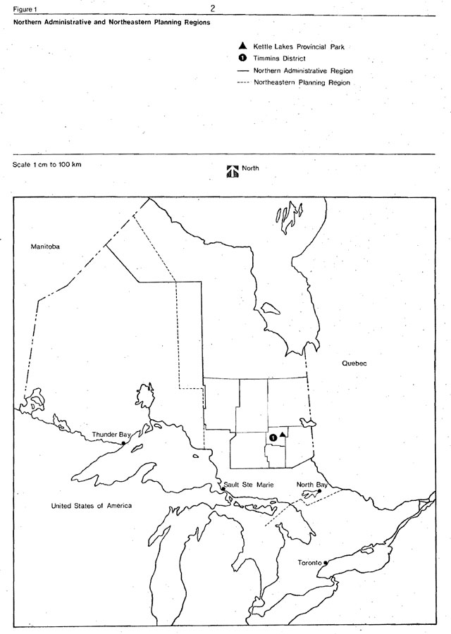
Kettle Lakes Provincial Park is situated in Northeastern Ontario, 645 km north of Toronto (U.T.M. coordinates, E509750, N5379320) and is located 40 km east of Timmins in German Township within the City of Timmins. The park is found within the Timmins District which is part of the Northern Administrative Region, Ministry of Natural Resources and in the Northeastern Planning Region as defined by the Strategic Land Use Plan of the Ministry of Natural Resources (Figure 1).
Figure 1: Northern administrative and northeastern planning regions
2.0 Regional setting
2.1 Climate
Kettle Lakes Provincial Park is situated in the Northern Clay Belt Climatic Region (Chapman and Thomas, 1968). Northern Ontario has been identified as modified continental, the climatic modification due largely to the influence of the Great Lakes and Hudson Bay. In summer, warm, humid air masses from the south alternate with cooler, drier air from the north to produce periods of clear, dry weather followed by warmer humid weather. In winter, there are numerous days of snow squalls and high winds alternating with clear, dry weather. On the average, summer days in this region receive one more hour of daylight than those of Southern Ontario.
The mean annual temperature for the climatic region is 1.1°C with a mean annual minimum temperature of -40°C. Mean daily maximum temperatures for January and July’ are -11.7°C and 23.9°C respectively and mean daily minimum temperatures for January and July are -24.4°C and 10.6°C respectively.
The mean annual frost free period is 92 days from June 8 through September 7 and the 160 day mean annual growing season extends from May 7 through October 13. The mean annual precipitation is 78.74 cm comprised of 40.64 cm rainfall and 215.9 cm of snowfall.
2.2 Physiography
The Northern Region contains a very diversified part of Ontario’s geological record. Two major structural provinces of the Precambrian Shield, the Superior and Southern are extensively exposed in the region. The Early Precambrian volcanic and intrusive rocks of the Superior Province have been the targets of decades of mineral exploration and are sources of vast economic mineral deposits. As such they have attracted continuous study on an increasing scale of detail.
The extensive Paleozoic record of Northern Ontario, mostly marine carbonate and evaporite sediments, comprises about half the area of the Northern Region. Although much of the record is confined to riverbank exposures in the Hudson and James Bay Lowlands, the stratigraphy is well known through numerous Federal and Provincial government surveys and subsurface drilling for oil and gas exploration.
The limited Mesozoic stratigraphy of Ontario is uniquely confined to the Cretaceous Basin, in the centre of the Northern Region. Here a variety of unconsolidated terrestrial sediments have survived postdepositional and glacial erosion. Their economic potential and scientific interest has stimulated much detailed investigation in recent years. They are exposed in only a few small areas on the surface and in river valleys.
The Late Cenozoic (Quaternary) record of the region is richly varied but, relative to southern Ontario, has riot been studied extensively in detail. Unconsolidated sediments and landforms of several continental glaciations blanket most of the land surface of the region. On an areal basis, less than thirty-five percent of the Precambrian Shield and less than two percent of the Paleozoic and Mesozoic areas are exposed at the surface. However, vertical exposures of Quaternary sediments, necessary for observation of stratigraphic relationships and sedimentary structures, are confined to valley walls and sand and gravel quarry operations. The numerous and varied landforms of glaciation and meltwater deposition are usually large and difficult to perceive by ground level observation in forested terrain.
Study of the Quaternary record has revealed the earliest glacial deposits known in the province, are rally extensive deposits of the last interglacial period, and major portions of the deglaciation history of the last 12,000 years. Most of the Northern Region was ice covered until about 8,000 years ago and details of this younger part of the record are particularly complete, including the widespread deposition of marine clay when. Most of the Hudson and James Bay Lowlands were flooded following complete glacial recession into Hudson Bay.
2.3 Vegetation
The vegetation of the Northern Region (M.N.R.) includes the Great Lakes - St. Lawrence Forest Region in the extreme south with the Boreal Forest Region occupying the major northern portion of the area. Within the Hudson and James Bay Lowlands occurs a transitional zone between the Boreal forest and the tundra.
The Timmins area is described as part of the Northern Clay Forest Region (Rowe, 1972). It is also described as occupying the central portion of the northward slopes of the Laurentian plateau in Quebec and Ontario. The forests of the section are conditioned by widespread surface deposits of water-worked tills and lacustrine materials and by a nearly level topography - inheritances from glacial Lake Barlow-Ojibway.
The impressive characteristics of the Northern Clay Forest Region is the seemingly endless stands of black spruce which cover the gently rising uplands as well as the lowland flats, alternating in the latter position with extensive sedge fens and sphagnum-heath bogs. Tamarack is an infrequent companion of the black spruce except in young stands. Extensive areas of spruce and cedar swamp occur, but eastern white cedar reaches tree size at only he better drained sites.
Improvement in drainage due to either changes in relief, shallowly buried coarse drifts, or position along water courses reflects good hardwood or mixed wood stands of poplar, white birch, balsam, fir, white and black spruce and jack pine. Jack pine has a dominant position on the drier sites created by glacial outwashes; eskers and moraines. Isolated groups of red pine and white pine are not uncommon on the more sheltered slopes of glacial-fluvial origin.
2.4 Population
In 1971, the Northeastern Planning Region (S.L.U.P. 1976) consisted of 559,850 people or 7.3 percent of the population of Ontario. Population projections indicate that by 2001 the planning region will exceed 775,000 people. Unlike most of the province, the census districts of Cochrane and Timiskaming experienced a decrease in population (-1.4 percent and -1.3 percent respectively) between 1961 and 1971 (Census of Canada 1976). The major population centres are located primarily along the Highway 11 corridor with the exception of Timmins. The major centres are associated with the mining and forestry industries.
Timmins designated as a sub-regional growth centre, has a population of 45,000. In the late fifties and early sixties the population of Timmins declined with a wanning gold mining operation. However, this was short lived because all available manpower from the declining gold producers was soon absorbed with the discovery of base metals by Texas Gulf.
In the Northern Region the degree of development declines rapidly away from the main travel corridors. Numerous small settlements of under 1,000 population are scattered throughout with several Indian communities located along the coasts of Hudson and James bays. The population of the unorganized areas consists of ten percent of the total population of the region (Treasury, Economics and Intergovernmental Affairs, 1976).
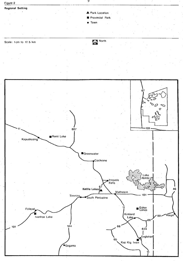
Major population centres within 60 km of Kettle Lakes include Timmins, Black River-Matheson, Iroquois Falls and Cochrane, with a total population including outlying areas of 60,000 persons. Within a 200 km radius of the park, which is the considered market area for the facilities offered in Timmins, lives a population in excess of 150,000 persons.
This includes centres such as Kapuskasing in the north, Englehart in the south.Chapleau in the west and Rouyn-Noranda, Quebec in the east. (Figure 2).
Population projections for the City of Timmins alone for the period 1976-2001 show an increase of 15,000 to a population of 60,000. It is anticipated that various forms of secondary industry will result from the establishment of a smelter complex within the city and create an expanded local economy (Timmins Official Plan, 1976).
2.5 Access
The major traffic artery is Highway 11 linking the Northern Region to Southern Ontario and Northwestern Ontario via North Bay and Thunder Bay respectively. Alternate routes to the region include Highway 144 and Highway 129 running north from the Trans-Canada route 17 from Sudbury and Thessalon respectively. These routes provide a circle routing to Highway 101, the major east-west connection route between Wawa and points west through Chapleau and Timmins to Rouyn-Noranda in Quebec and points east (Figure 2).
Kettle Lakes Provincial Park is located on Highway 67 which is a short north south connection between Highway 11 and Highway 101, situated 40 km east of Timmins City Centre.
The Ontario Northland Railway runs daily train service between Toronto and northern points. The park is situated 15 km south of Porquis Junction and 40 km east of Timmins, regular daily stops for the Ontario Northland Railway.
Bus connections are available into and out of Timmins to most northern communities and from Southern Ontario on a daily basis to any of these routings pass in front of the park gate or within 2 to 5 km at the junction of Highway 101 - 67 or the Village of Connaught respectively.
The Timmins Transit bus system has for the last two years run a shoppers, service for outlying residents of the city. This service passes the park gate at 10 a.m. and 5 p.m. each Friday. As local demands increase, the municipal service may be extended.
Air transportation is a major factor in northern travel patterns due to distance and time relationships. Timmins is served daily from Toronto by regular Air Canada flights. Daily NorOntair connection flights originate out of Timmins to other northern centres as well as other commercial carriers with scheduled runs to the far northern settlements on Hudson Bay and James Bay and other more remote inland areas.
The park is well situated to serve the local needs of the resident populations of Timmins, Iroquois Falls and Matheson, as well as travellers passing through the James Bay Frontier tourist region. The park’s strategic location close to all major northern access routes provides an excellent dormitory base for the out of region visitor to explore the area’s many unique attractions combined with in-park activities at a leisurely pace.
Figure 2: Regional setting
3.0 Market analysis
3.1 Region
Tourism has become a major industry in the north where a wide variety of public and private campgrounds, private tourist establishments and vast amounts of Crown land occur. Approximately 327 commercial tourist establishments are located in the region, 26 in Timmins District. Most of these businesses are located adjacent to major traffic arteries. Twenty fly-in outfitters and 37 commercial tent and trailer campgrounds also operate in the region. Four outfitters and 8 campground operators are located in Timmins District.
Although the Northern Region has good potential for tourism, it faces the problem of distance from major markets. This is compounded by recent increases in gasoline costs and a recent trend by Canadians arid Ontarians to take fewer domestic trips in favor of non-domestic trips. Since the early 1970s, the length of domestic vacation trips have shown declines. When all these factors are combined it suggests that in the future fewer tourists can be expected to travel to the Northern Region and secondly that the percentage of local Kettle Lakes use should show an increase over the next few years The Kettle Lakes Provincial Park area, with a population of 60,000 persons within 60 km, is deficient in lodging and water oriented opportunities. This is particularly evident in the shortage of sand beaches and available campsites in July and August in both the commercial and public sectors.
Kettle Lakes Provincial Park contains close to 50 percent of the best available public and potential beach resources in the Timmins District as well as a large percentage of the available public campsites. The park, therefore, serves as the major day-use facility for the City of Timmins and provides a portion of the camping needs for the local population. Out of region visitation in 1976 averaged 5 percent United States, 4 percent out of province, 29 percent Southern Ontario and 20 percent other Northern Ontario (Sudbury, Thunder Bay, et cetera). United States visitation has dropped an estimated 1-1/2 percent since 1974. Southern Ontario visitation has remained stable and is expected to remain at approximately twenty-nine percent of the total camper-days for at least a couple more years.
In summary, park visitation at Kettle Lakes reflects 92 percent local day-use and 41 percent local camper use - making it an important public recreational asset to the surrounding communities.
3.2 Provincial parks
There are at present 17 provincial parks in the Northern Region (M.N.R.). Of these, 12 are available to highway oriented camping units. Of the remaining five parks, Polar Bear is a Wilderness park located on the shore of James Bay and Hudson Bay and is accessed only by aircraft or boat. Tidewater, a Natural Environment parkis located on an island in the Moose River near Moosonee and is accessible by train and boat. Three waterway parks - Chapleau-Nemegosenda rivers, Mississagi River (Chapleau District) and Winisk River (Moosonee District) occur in the region. The first two are accessible by vehicle, the latter by aircraft only. All three provide good backcountry camping and canoeing experience.
Of the 12 regional parks located along major road corridors, five are recreation parks with total of 426 campsites and seven are natural environment parks with a total of 630 campsites. Extensive day-use facilities are also available at all road access parks. The occupancy rates are substantially higher in these parks located adjacent or near the larger population centres.
Several provincial park reserves are present in the region. The La Motte Reserve near Gogama and Dana-Jowsey Reserve west of Timmins would have, if developed, a noticeable effect on Kettle Lakes.
3.3 Municipal and private parks
The majority of private and municipal parks within 100 km of Kettle Lakes Provincial Park tend to complement and supplement park uses and recreation needs of the area (Table 1). Clients often alternate between private and provincial parks as conditions change and campsites in provincial parks become scarce, particularly on weekends. Generally a deficit of camping areas, both provincial park and private park is evident for the Timmins area. Most existing facilities are generally heavily over-used. Some private campground expansion is in progress.
A good deal of day-use activity occurs in the private and municipal parks, but there is little room for beach oriented expansion for present facilities and a noticeable shortage of good beach areas is appearing in and around Timmins. The problem is further compounded when good beach areas are in private ownership or suffer from contaminant leaching.
Table 1: Private and municipal camping parks within 100 km of Kettle Lakes
| Highway access | Parks | Area | Number of Campsites | Municipal | Private |
|---|---|---|---|---|---|
| 101 | Reid Lake Campground Stock Township | 2 | 70 | X | |
| 576 | Horseshoe Lake Campground | 8 | 75 | X | |
| 629 | All Seasons Park Mountjoy Township | 32 | 56 | X | |
| 11 | Drury Park Cochrane | 30 | 140 | X | X |
| 11 | Pull-in Campground Matheson | 11 | 5 | X | |
| 11 | Terry’s Campground Cochrane | 220 | 20 | X | |
| 11 | Vi-Mar Campgrounds | 1 | 7 | X | |
| 11 | Hi-way Beach Nellie Lake | 121 | 90 | X | |
| 655 | Texagulf Campgrounds Bigwater Lake | 200 | 50 | X | |
| 655 | J.C. Park Charlebois Lake | 200 | 15 | X | |
| 101 | Wawaitin Lodge Waiwaitin Falls |
10 | 15 | X | |
| 101 | Nighthawk Lake | 3 | -- | X |
3.4 Other outdoor recreation opportunities
Six canoe routes occur either completely or partially within the Timmins District. All provide a variety of outdoor challenges as does - hunting for big and small game; waterfowl and upland birdsand fishing for most major game fish. Additional opportunities are provided by picnicking and swimming areas and winter outdoor sports and a number of tours associated with the mining and forestry industries. Activities in the upswing in the area appear to be cross-country skiing, rockhounding, backpacking and nature photography.
3.5 Regional And Local Recreational Needs
In 1973 the Northeastern Ontario Recreation participation survey collected and presented information regarding the outdoor recreational patterns of Northeastern Ontario residents.
!n the Timmins area, survey results indicate 53 percent of the total recreational occasions were oriented to outdoor activities. Of these outdoor activities the greatest participation in the Northern Administrative Region was for nature appreciation, 20 percent, bathing 15 percent, picnicking 20 percent and fishing 17 percent. The lowest rates of participation were for skiing and snowmobiling.
The survey also indicated 67 percent of the total outdoor recreational occasions occurred in conjunction with a day trip as opposed to an extended trip where at least one night was spent away from home.
In the Northeastern Planning Region and the Northern Administrative Region respectively private lands received the most use for outdoor activities (46 and 30 percent) followed by Crown lands (37 and 34 percent), commercial and municipal parks (5 percent each) and provincial parks (6 and 8 percent).
Background studies for the Northeastern Planning Region identified public concern for certain recreational and cultural facilities for the region. They identified the preservation of historic sites and buildings and the need for increased camping and boating facilities. Other concerns were expressed for increasing provincial parks) hiking trails and other year-round recreational and tourist facilities.
In the Timmins area) a more specific need centres on adequate bathing beaches and overnight accommodation in the form of overnight campsites and housekeeping cabins.
4.0 The park
The Ontario provincial park system of which Kettle Lakes Provincial Park is a component, makes a very distinctive contribution to recreation in Ontario.
The goal and objectives of the provincial parks system are:
Goal
To provide a variety of outdoor recreation opportunities, and to protect provincially significant natural, cultural and recreation environments in a system of Provincial Parks.
Objectives
Protection
To protect provincially significant elements of the natural and cultural landscape of Ontario.
Recreation
To provide Provincial Park outdoor recreation opportunities ranging from high intensity day-use to low intensity wilderness experiences.
Heritage appreciation
To provide opportunities for exploration and appreciation of the outdoor natural and cultural heritage of Ontario
Tourism
To provide Ontario’s residents and out of-province visitors with opportunities to discover and experience the distinctive regions of the Province.
Kettle Lakes Provincial Park contributes specifically to the recreation and tourism objectives by providing intensive recreational opportunities to both the local and non-local resident.
4.1 Legal status
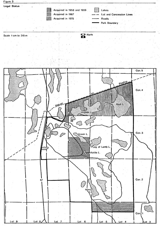
Kettle Lakes Provincial Park was formally established by Ontario Regulation 144/57 and designated as a Recreation Class Park under the 1967 Park Classification System. Two inholdings of .40 and 64 ha were acquired in 1958 and 1959 respectively. In 1967 65.6 ha of Crown land was acquired in the north half of the north half of lots 4 and 5, Concession, German Township. A further acquisition of three properties and an inclusion of additional Crown lands, totaling 173.2 ha, across the northerly expanse of the park proper and including all of Hughes Lake and Mud Lake was completed in 1975. The park is now established by Ontario Regulation 517/78 and includes all the lands acquired in 1967 and 1975. (Figure 3)
4.2 Park boundaries
Kettle Lakes Provincial Park is contained entirely within German Township and is comprised of a total of 1,261 ha. Partial boundary surveys, as well as interior references, were established in 1958 by J. Lonergan, Ontario Land Surveyor, between Concession II-III and Lots 3-8 in German Township covering the majority of the original boundary as well as interior roads and lakes. The original boundary was re-cut in 1975-76 with several of the original survey corner posts being tied in.
Figure 3: Legal status
4.3 Land disposition
No patented lands, leases or unauthorized buildings exist within Kettle Lakes Provincial Park.
Patented lands which abut the park are mainly 64 ha blocks in a checkerboard fashion.
A recreational cottage subdivision exists on McInnis Lake adjacent to the northwest boundary. Two adjacent parcels of land, one on the north and one on the west boundary presently have year-round residents. The remainder of alienated lands are unoccupied.
4.4 Access Roads
The main park entrance is located on Highway 67. Two low quality emergency service roads exist in the park - one from the south and .the other from the east boundary. Both roads are controlled by locked gates at the park boundaries. A third service road presently touches Hughes Lake. This is the continuation of the McInnis Lake subdivision road and services recent acquisitions located on Hughes Lake.
4.5 Forest activities
The park area was harvested for timber and fuelwood for several decades prior to 1950 and has since burned over several times. A concentrated planting program in the park area from the 1950s through to the present day has seen over 1-1/2 million trees planted within the park. The majority of planting occurred between 1957-1972 and consisted mainly of jack pine growing stock. Other species planted in smaller numbers included white pine and red pine, larch, white spruce and cedar. An attempt at establishing scotch pine was completely unsuccessful.
Scleroderris Canker (Sclerederris logerbergii gremmen) was recognized in the park plantation in the late 1960s and serious infestation noted in 197. A removal program for highly infested trees began in 1973 and continues to the present. The disease has destroyed the scotch pine plantings and has had serious effect on many of the jack pine plantations. It affects mainly young trees but many areas have reached an age and height class where the disease may be controlled by the occasional removal.
Minor plantings and infillings have taken place in the park since 1973. Planting stock is obtained from the tree nursery in Kirkland Lake and planted according to a pre-planned ten year schedule. The plan specifies that only a mix of species, age classes and native species be planted.
Cutting operations in the park are not allowed except for the removal of dangerous trees or in conjunction with planned development or forest protection activities.
4.6 Mineral exploration
Bedrock mineral potential within Kettle Lakes Provincial Park is high, particularly for the discovery of gold deposits.
Most major gold occurrences are associated with mafic metavolcanic and metamorphosed ultramafic rocks south of the Porcupine-Destor Fault; and with predominantly coarse clastic metasedimentary rocks (conglomerate and greywackes) immediately north of the fault. These environments lie outside the park boundary. Of particular relevance to the park is the series of gold occurrences in Hoyle and Matheson townships (west of park) situated along the contacts between mafic metavolcanic and metasedimentary rock units. At least one mafic metavolcanic lens probably extends through the park. Such lenses are thought to be favourable targets for gold exploration.
No major mineral occurrences have been reported in the immediate vicinity of Kettle Lakes Provincial Park. Hollinger Mines Limited has conducted a gold exploration program throughout a large block of claims directly south and west of the park during the past few years but no important discoveries have been reported to date. It is possible that the rate of gold exploration in the Timmins area will increase in the next few years (depending on the price of gold and the general economic climate). The discovery of significant gold mineralization immediately east or west of the park in future could result in pressure to allow mineral exploration or mining within the park (D.S. Hunt, 1978). Currently mining is not permitted by regulation under The Provincial Parks Act.
A south-southwest striking esker outwash complex dominates most of the park. This esker is expected to contain a large volume of good quality gravel and sand.
4.7 Wildlife
The park area is entirely within and part of Timmins District Trapline #44.
Although hunting is prohibited within Kettle Lakes Provincial Park, hunters may use the park campground while hunting outside the park. Also, controlled trapping of nuisance beaver has always been an important management strategy for the park.
4.8 Fisheries
The 21 lakes in Kettle Lakes Provincial Park are managed as part of the District Sport Fishery under the Kettle Lakes Management Plan. Legislation has been in effect for several years which prohibits the use of outboard motors on all park lakes except for Hughes Lake (Reg. 696/29-(11) P.P.A.).
Introductory stockings of brook and rainbow trout have been made in many park lakes since 1950 in order to diversify and expand the local trout fishery and to improve the park experience. Warm water species such as smallmouth bass, northern pike and yellow perch are also present in some lakes.
The use of live bait fish is permitted in all park lakes. Recently some lakes have been reclaimed in order to re-establish a trout fishery.
The heaviest fishing pressure in the park occurs during the summer months on Green Lake and Irrigation Lake. These two lakes have been used to the greatest degree because of the picnic and swimming areas around their periphery and the excellent angling they provide.
4.9 Winter recreation
The only winter recreational facility available at Kettle Lakes Provincial Park is a system of cross-country ski trails. Three prepared loop trails are groomed and made available to the public from December to March.
Activities such as snowmobiling are also permitted on roads, parking lots and lakes while snowshoeing has no restrictions. Winter angling is very popular, especially in Green, Heart, Deer and Irrigation lakes.
The park road up to the concessionaire store is plowed on a regular basis to provide access and parking for the winter recreationalist.
4.10 Visitor services
The first formal attempt to provide a visitor services program at Kettle Lakes was during the summer months of 1972. The program was limited to gathering information and background material. The program provided one self-guided trail, two nights of movies and three guided hikes a week.
Currently, the program is operated daily by a minimum of two visitor services staff. It is a recreation intensive program which provides guided hikes, two self-guided trails, children’s programs, evening programs, star watches, bush skill demonstrations, wilderness cooking, orienteering, school programs plus a wide array of exhibits and information boards.
4.11 Park development
Camping, day-use and support facilities are mainly concentrated around four lakes within the park (Bullfrog, Island, Green and Slab). Fifty campsites are located around Bullfrog Lake and 117 around Island Lake. Table 2 provides a list of facilities available in the park. Fourteen km of nature and fitness trails and thirty km of service and emergency roads provide access to park values and facilities. The park emergency exit roads provide avenues of escape in the event of forest fires. Even though the emergency roads are gated to prevent vehicular access, some problems exist with motorcycles entering via these routes (Figure 4).
Table 2: 1979 Inventory of park facilties
| Park facilities | Area/capacity |
|---|---|
| Swimming Beaches Camper’s Beach - Dry |
936 m2 |
| Swimming Beaches Camper’s Beach - Wet |
927 m2 |
| Day-use Beach - Dry | 5,404 m2 |
| Day-use Beach - Wet | 7,426.3 m2 |
| Internal Roads | 30 km |
| Camping Units | 167 |
| Organized group camping areas (a) Number of ha |
.62 |
| Organized group camping areas (b) Total Capacity |
150 |
| Picnic Areas | 6.56 ha |
| Picnic Tables | 650 |
| Parking Area | 500 vehicles |
| Wells | 3 |
| Water Pressure Systems | 4 |
| Docks | 3 |
| Boat Launching Ramps | 1 |
| Hydro Lines | 1.9 km |
| Trails, walking, nature and other | 14 km |
| Cross-country Ski Trails | 9 km |
| Park Office | 1 |
| Summer Staff Living Quarters | 3 |
| Maintenance Building | 1 |
| Concession Building | 1 |
| Change Houses | 6 |
| Comfort Stations | 2 |
| Earth Pit Toilets | 2 |
| Vault Toilets | 6 |
| Vault Privies | 37 |
| Picnic Shelters | 2 |
| Outdoor Exhibit Centres | 2 |
| Amphitheatre | 1 |
| Pumphouses | 4 |
| Shower Building and Laundromat | 1 |
| Wood Yard | 1 |
| Trailer Dumping Station | 1 |
| Visitor Services Office (Temporary) | 1 |
Figure 4: Park facilities
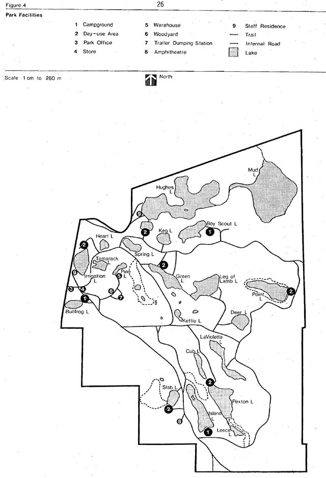
Table 3: Capacity of existing recreational facilities*
| Existing Development | Annual Optimum User-day Potential |
1979 User-Day Consumption |
Surplus or Deficit of User-Day |
|
|---|---|---|---|---|
| Campsites | 167 | 40,080 | 24,848 | + 15,232 |
| Day-Use Area Picnic Area |
6.56 ha | 46,330 | 15,272 | + 36,835 |
| Day-Use Area Day-use Beach - Dry |
5,405.0 m2 | 20,849 | 15,272 | + 11,354 |
| Day-Use Area Day-use Beach - Wet |
5,855.4 m2 | |||
| Trails Kettle Trail (nature) |
2.5 km | 3,900 | 4,250 | 350 |
| Trails Beaver Trail (nature) |
2.0 km | 3,125 | 3,200 | 75 |
| Trails Point Lake(nature) (guided) |
3.0 km | 4,700 | 128 | + 4,572 |
| Trails Leece Lake Trail (guided nature) |
2 km | 3,125 | 133 | + 2,992 |
| Trails Physical Fitness Trail** |
2 km | 20,000 | 16,000 | + 4,000 |
| Trails Cross-country Ski Trail*** |
9 km | 18,000 | 5,320 | + 12,680 |
*based on a 100 day season.
**20 person/1 km for Fitness Trail (Legouffe, 1977).
***10 person/1 km for Cross-country ski trail (Legouffe, 1977).
4.12 Facility capacity
With 167 campsites, Kettle Lakes can annually provide 40,080 camper-days based on a 60 percent campsite occupancy rate - 4 persons per campsite and 100 day season (Table 3). Over a 62 day July/August season, the park can provide an optimum of 24,850 camper-days as compared to a present use, over the same time period, of 19,491 camper-days.
The day-use beach areas can supply 20,849 user-days, over a 75 day season. The picnic areas can supply 46,331 user-days over a 100 day season (Appendix 1).
Kettle Lakes has approximately 23 km of nature, fitness and crosscountry ski trails with a potential to provide 30,200 user-days during the calendar year.
4.13 Park use
Twenty years of park operations and statistics indicate that the greatest percentage of park visitors are day-users. A large percentage of the visitors plan their stay for a very short period - usually averaging four hours per day.
Indeed, the park has traditionally attracted a great deal of dayuse; this is reflected in the fact that daily vehicle permits sold average 3,500 each year. In 1979, 3,420 day-use and 44 annual permits were sold, representing a substantial number of people (Table 4). Dayuse sales can vary considerably from year to year - depending on the weather conditions. During the park seasons of 1978 and 1979, day-use totalled 9,500 and 15,272 user-days respectively. During fall, winter and spring, for the same years, it is estimated that an additional 18,000 user-days per year were consumed by fishermen, campers, picnickers, snowmobilers, snowshoers, cross-country skiers and educational groups.
Table 4: Park use statistics
| Variables | 1970 | 1971 | 1972 | 1973 | 1974 | 1975 | 1976 | 1977 | 1978 | 1979 |
|---|---|---|---|---|---|---|---|---|---|---|
| Visitors | 70,527 | 68,826 | 43,119 | 76,844 | 58,175 | 42,318 | 58,703 | 48,760 | 38 195 | 46,163 |
| Campers | 9,761 | 13,944 | 11,330 | 17,452 | 11, 877 | 15,237 | 12,733 | 12,380 | 9,216 | 9,591 |
| Camper-days | 20,204 | 27,318 | 21,979 | 29,050 | 26,357 | 31,597 | 35,388 | 36,710 | 23,791 | 24,848 |
| Average length of stay | - | 2.3 | 2.1 | 2.1 | 2.1 | 2.1 | 2.8 | 3.0 | 2.6 | 2.3 |
| Average property size | 4.0 | 4.0 | 4.2 | 4.2 | 4.0 | 3.9 | 3.9 | 2.9 | 2.9 | 2.6 |
| July/August Occupancy (%) | 51 | 66 | 52 | 67 | 54.6 | 73 | 73 | 71 | 47 | 56 |
| Family vehicle permits | – | – | – | – | 3,608 | 4,475 | 4,426 | 3,261 | 2,814 | 3,420 |
The majority of campers (90 percent) are from Ontario, some (4 percent) came from other provinces, and the remaining six percent originate in the United States.
Of the Ontario campers, 48 percent originated from the Timmins centred region, reflecting the trend for people to stay in the area during their summer holidays.
The park has been attracting a great deal of interest from organized groups for either day-use or camping. In 1979, 1687 campers in 56 groups stayed in the park while 4,356 people in 274 groups used the dayuse facilities.
In 1979, senior citizens utilized 2,111 camper-days which represents a 20 percent increase over 1978. Also in 1979, senior citizen day-use amounted to 1,116 visitors) an increase of 6 percent.
The Kettle and Beaver’ self-guided trails received 7,450 visitors while the guided trails received 361 visitors. The heaviest use occurred on the fitness trail which received 16,000 visitors. The cross-country ski trails were utilized by 5,320 persons during the winter of 1979.
Fishing, recreational paddling, photography, recreational driving, snowshoeing, snowmobiling and nature appreciation are also popular in the park.
5.0 Biophysical resources
5.1 Climate
Climate is regarded as an important factor influencing recreational pursuits. Visitor statistics often reflect this fact particularly in Kettle Lakes Provincial Park where May and September weather conditions become unpredictable and park visitation statistics show great variability.
Mean July daily temperatures range from l0.6°o to 23.9°C with an average daily temperature of 17.2°C. Extremes of over 38°C and less than 0°C have been recorded. January mean daily temperatures range from -24.4°C to -11.7°C with an average daily temperature of -18°C. Extremes of -l0°C and -46°C have been recorded. Annual precipitation (rain plus rain equivalent of snow) averages about 78 cm. Average annual snowfall in Timmins is 216 cm. July and August rainfalls average 7 cm and 8 cm respectively.
Kettle Lakes lies in an area which is influenced by several air masses including moist sub-tropical air moist or dry arctic air and dry continental air masses. For this reason extreme and rapid variations in weather often occur. The variable weather and relatively cool average daily temperatures in summer are offset by long hours of daylight and low humidity.
5.2 Geology
Bedrock is not exposed within the park. On the basis of bedrock outcrops in surrounding townships, the park is assumed to be underlain by Early Precambrian (Archean) metasedimentary rock (2.5 billion years old) consisting of sandstones, siltstones; slates, and conglomerates and one or more thin zones of mafic volcanic flows and pyroclastic rocks. These once stratified rock units have been deformed into a subvertical position and trend east-west through the park. Their combined stratigraphic thickness, including repetition due to folding, is more than nine km from north to south. Linearly the zone of metasediments is identifiable from Holloway Township, 23 km east of the park, to Denton Township, 15 km west of it.
The Precambrian bedrock topography of the park is unknown because of the masking cover of unconsolidated Quaternary and glacial meltwater sediments that completely obscures the bedrock surface. The thickness of unconsolidated sediments has not been measured in the park. Data from mineral exploration drilling about 8 km north of the park in Dundonald Township indicates that the thickness of glacial debris is variable, frequently exceeding 15 m and up to 75 m at a few sites.
The Quaternary sediments on the surface of the park are dominated by fine to medium grained sand and minor amounts of silt. A detailed survey probably would outline several gravel occurrences. A small area northeast of Duck Lake is covered with silt and silty clay. Scattered throughout the park are numerous glacially transported boulders of many Precambrian lithologies. They range in size from one half to four meters in diameter.
These sediments were deposited by meltwater streams flowing within and beyond the northward receding margin of the last continental ice sheet into proglacial lake Barlow-Ojibway, approximately 9,500 years ago. They form an outwash plain and a small esker that trends southeastward through the park part of an esker-delta complex that extends from Frederick House Lake to Michie Township, west to Watabeag lake. Most of the park lakes are kettle lakes formed by the collapse of outwash sediments that buried dislodged blocks of glacial ice. As ice recession progressed northward, the water level of Lake Barlow-Ojibway lowered and wave activity modified the surface land of the park, reducing the height of the esker to that of the surrounding outwash plain.
Today, the gently hummocky plateau of the outwash plain is disrupted only by negative relief of the steep walled kettle lake basins. The plateau surface is commonly five to fifteen metres above the surface of the park lakes.
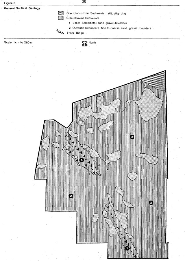
Vertical exposures of the Quaternary sedimentary record is poor within the park. Slumped exposures of fine sand occur on the north shore of Hughes lake. Large excavations for sand and gravel south of the park along Highway 101 reveal the south dipping, deltic structure of the outwash sands. Adjacent to the outwash sediments of the park and the southeast trending glaciofluvial complex, deeper basins of proglacial lake Barlow-Ojibway accumulated thick deposits of varved silt and clay. Frederick House Lake is a contemporary remnant and contains numerous vertical sections of varved sediments on its north and northeast shore. Within the park, the glaciolacustrine record is obscurely represented by the silt and clay deposits of Mud Lake (Frey, 1977)(Figure 5).
Figure 5 General surfical geology
5.3 Hydrology
One of the most notable features of the park is a series of 21 lakes scattered along the outwash plain associated with the esker system. The majority of the lakes in the park are believed to be kettle lakes formed by depressions made by large blocks of ice which became embedded in till left by the retreating glaciers. Heltwater from these ice blocks and groundwater infiltration eventually filled these depressions to form steep, sloping kettle lakes. Characteristically, most of these lakes are land-locked, having no surface inflow or outflow and, consequently, are entirely dependent upon rainfall and groundwater infiltration for recharge. The generally flat topography of the park ensures that this recharge is confined to slow seepage rather than vigorous flushing, with the result that residence time in these lakes is substantial. High retention time and, consequently, limited assimilative capacity render kettle lakes highly susceptible to inputs.
Two of the largest lakes in the park, Hughes and Mud lakes, are quite different from the rest as they have a known surface outflow. These two lakes are connected to each other and the Frederick House Lake system (Arctic Watershed) through a series of beaver controlled outlets (Griffiths and MacDonald, 1977).
In the past, the overriding concern with the park’s aquatic system was the threat of eutrophication and bacteriological contamination resulting from the various park activities. Recently, concern has been expressed over the possibility of acidification and heavy metal contamination, arising from a proposed Texasgulf copper smelter and refinery to be located at Hoyle, approximately 10 km west of the park. In view of this potential problem an intensive water monitoring program has been initiated jointly by the Ministry of Natural Resources and the Ministry of the Environment in an attempt to monitor possible changes in acidity (ph), heavy metal content and nutrient levels. Results of this study will be invaluable in assessing the present quality status of the lakes.
Table 5: Hydrological data
| Name | Area (ha) | Maximum Depth (M) | Mean Depth (M) | Oxygen Top |
Oxygen Middle |
Oxygen Bottom |
Secchi (M) |
pH |
|---|---|---|---|---|---|---|---|---|
| Boy Scout | 5.02 | 22.00 | 4.58 | 6.8 | 9.8 | 0.0 | 4.5 | 7.0 |
| Bullfrog | 2.29 | 5.19 | 2.47 | 9.0 | 2.8 | 7.0 | ||
| Deer | 3.81 | 16.47 | 4.82 | 9.0 | 10.0 | 9.0 | 4.0 | 5.5 |
| Green | 5.99 | 10 68 | 3.78 | 10.0 | 7.0 | 3.0 | 4.8 | 8.0 |
| Heart | 1.26 | 11.34 | 3.08 | 10.0 | 12.0 | 9.0 | 2.8 | 6.5 |
| Hughes | 32.40 | 16.47 | 2.29 | 10.2 | 8.6 | 0.0 | 3.0 | 8.0 |
| Irrigation | 6.32 | 24.40 | 8.14 | 11.0 | 9.0 | 0.0 | 7.4 | 8.0 |
| Island | 9.36 | 10.98 | 3.14 | 8.4 | 7.4 | 4.7 | 8.0 | |
| La Viollette | 6.32 | 10.98 | 2.44 | 10.0 | 7.2 | 5.7 | 7.5 | |
| Leg-of-Lamb | 7.94 | 18.61 | 5.49 | 8.6 | 4.4 | 0.2 | 5.7 | 7.0 |
| Pexton | 8.99 | . n/a | n/a | n/a | n/a | n/a | 3.0 | n/a |
| Pine | 1.30 | 5.19 | 1.83 | 7.0 | 2.4 | 6.0 | ||
| Point | 8.71 | 5.49 | 1.01 | 8.2 | 6.6 | 1.9 | 8.0 | |
| Slab | 2.75 | 11.29 | 5.49 | 8.8 | 2.9 | 6.5 | ||
| Spring | 2.63 | 16.17 | 5.12 | 8.0 | 6.0 | 0.0 | 3.5 | 6.5 |
| Cub | 2.19 | 1.83 | 0.67 | 2.0 | 7.0 | |||
| Mud | 36.77 | 1.53 | 0.82 | 10.2 | 1.5 | 8.0 |
The lakes can support different fisheries (cold or warm) depending on the established water criteria.
Unfortunately, temperature regimes in the park lakes have not been extensively studied and, consequently, the suitability and capability of these lakes to support various fish species cannot be accurately determined. However, data collected to date suggests the shallower lakes (e.g. Bullfrog mean depth 2-4 m, Island 3.0 m) are more suitable for warm water fish species (perch, bass) and that the deeper lakes (e.g. Slab 5.5 m) appear to be better habitats for cold water species (e.g. brook, kamlnops trout) (Griffiths, MacDonald, 1977).
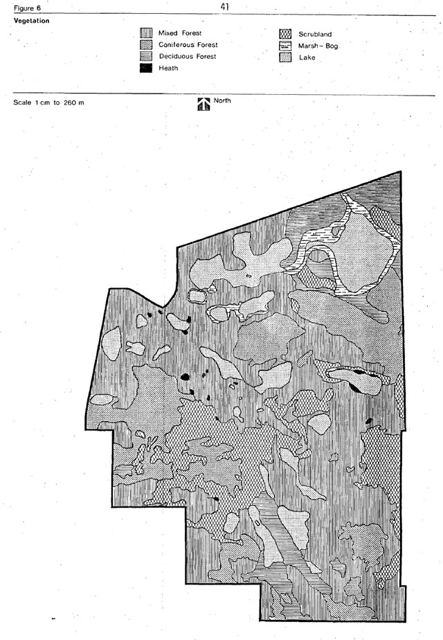
5.4 Vegetation
Plant communities in the park vary with topography, soil type and moisture and range from those adapted to dry, sandy upland conditions to ure anthose adapted to low, damp bog and open water habitats. The biotic communities in the park primarily owe their characteristics to the park’s location on an outwash complex, which characterizes sandy situations and, to the northeastern clay belt zone, which characterize wet to very wet clays. However, other natural and unnatural occurrences have influenced these habitats such as forest fires, beavers, logging, planting and recreation.
Kettle Lakes Provincial Park is located in the southern extremity of the northern clay section (B4) of the Boreal Forest Region defined by Rowe (1972) and the Clay Belt region described by Baldwin (1958) and Halliday (1937). Black spruce dominates poorly drained areas of the clay belt while jack pine is found extensively on well drained eskers and outwash plains. Both white and black spruce are common understory associated on wet soils. Trembling aspen often occurs in pure stands on well drained finely textured soils or in association with white birch.
Jack pine dominates the tree cover and accounts for approximately 60 percent of the forested park area. It occurs as scattered growth on severely burned areas (sanbarrens), as pure forest stands on sand flats and in association with poplar and or birch on well drained, rolling sand lands.
Trembling aspen is the second most common tree in the park, accounting for approximately 20 percent of the tree cover. It occurs as pure stands on the esker complex and in association with white birch and occasionally jack pine on rolling sand lands.
White birch occupies only 5 percent of the forested park area and occurs largely in associat on with trembling aspen, with the exception of a small pure birch stand located southeast of Leg of Lamb Lake.
White spruce is a common, but subordinate member of most deciduous and mixed forests in the park, occurring on sand lands and clay plains in association with aspen, white birch and jack pine. No major white spruce stands have been discovered in the park and it appears likely that such development has been curtailed by frequent fire occurrence in the area.
Although black spruce is common in the clay belt (Baldwin, 1958) it has a very limited distribution in the park. It occurs occasionally as small dense groves on wet sand land heaths along the southeastern boundary of the park and as an uncommon associate in a poplar-balsam fir white spruce forest located on a clay plain, northeast of Mud Lake. Occasional presence of black spruce has also been recorded on sand plains in a jack pine forest association.
Balsam fir is a minor, but widely distributed tree in the park occurring as a dominant with white birch on the clay plain (northeastern section of the park), as a successional species after logging east of Mud Lake and as an associate in the jack pine-black spruce on tundraheath sand lands.
Eastern larch is uncommon in the park and is found only occasionally in kettle lake bogs and on peatlands in association with pure black spruce and cedar-black spruce stands.
Despite a history of disturbances and extensive development, the park supports a considerable variety of plant species. A preliminary species list compiled, records a total of 378 plant species, 355 of which are vascular plants. These numbers compare favourably with 236 vascular plant species reported by Perraton (1975) in Esker Lakes, a natural environment park located approximately 100 km southeast of Kettle Lakes Provincial Park. It should be noted, however, that a majority of habitats in Kettle Lakes Provincial Park are represented by sand barrens, jack pine stands and rolling sand land deciduous forests, all of which support a limited variety of plant species. It is only through the presence of kettle lakes, kettle bogs and the clay plain communities that the species, richness for the park as a whole is greatly increased (Figure 6).
5.5 Fauna
Moose and black bear are the principle large mammals in Kettle Lakes. Moose are most evident in the Mud Lake area. The abundance of berries, as well as the location of a garbage dump near the park, attracts bears to the area. The timber wolf, lynx and snowshoe hare are seen occasionally.
Other mammals in the park include beaver, weasel, mink, otter, fox and muskrat. Squirrels and chipmunks are abundant. Brown bats and garter snakes are particularly numerous around the developed areas. Also common are several species of toads and frogs.
Figure 6: Vegetation
A wide variety of avian species are known to nest in Kettle Lakes. Ruffed and spruce grouse are common. Major waterfowl nesting areas are situated in the Mud Lake area. Kettle Lakes is also used as a stopover during the spring migration of song birds, notably warblers. The best bird-watching opportunities are in early summer when grackles, blackbirds, cedar waxwings, yellow warblers, boreal and black-capped chickadees, eastern phoebes, downy and pileated woodpeckers, gulls, woodcocks, grouse, coopers and red tailed hawks, common loons and great blue herons can be seen.
Fish species include brook trout, kamloop trout, northern pike, smallmouth bass, yellow perch and white suckers.
6.0 Cultural resources
6.1 Prehistory
With the exception of a chert knife found near Slab Lake no other archaeological finds have been located in the park area.
However, an important discovery was made near Moose Lake several kilometres east of the park boundary. These finds were found to be provincially significant (Pollock, 1975). Archaeological research was conducted for several years at the Moose Lake site by Paul Sweetman, Dr. J. V. Wright, John Pollock and assistants.
Research to date indicates that the Moose Lake area (Kettle Lakes Provincial Park would fall within the hunting territory of the band) was first occupied by a band of Nomadic hunters called the Shield Archaic Peoples about 5,000 years ago. Around 2,000 years ago, a second group - the Laure Z Tradition People - occupied Moose Lake. This group used different tools from their predecessors including decorated, pointed bottom clay pottery vessels.
Moose Lake is accessible directly from the Abitibi River system and by portage from the Frederick House system. An overland trail is believed to have existed linking Moose Lake to the Frederick House system via Kettle Lakes Provincial Park (Pollock, 1976).
At present, no definitive study of the prehistory of the park area has been undertaken. It is, however, conceivable that the general area of the park was used in historic times by Abitibi Algonkians or Moose River Cree. Caribou were abundant on the flat sandy area of the esker complex, and this may have prompted the people to travel into the park area.
6.2 Fur trade
The first white man appeared in the area in the early 1700s. These were French traders from New France who exploited the area’s vast resources. It is postulated that the region was trapped by the famous explorers, Radisson and Groseillers, who had an outpost on Night Hawk Lake. Further information on this subject is difficult to obtain because of its location in the Archives of Paris, France and Rome, Italy.
The Hudson’s Bay and North West companies established several trading posts in the area during the late 1700s - the most notable being the Kenogamissi Hudson’s Bay Company Post in 1794, Mattagami North West Company Post (founded 1785) and the North West Company Post on Devil’s Island at Frederick House in 1786 (Figure 7).
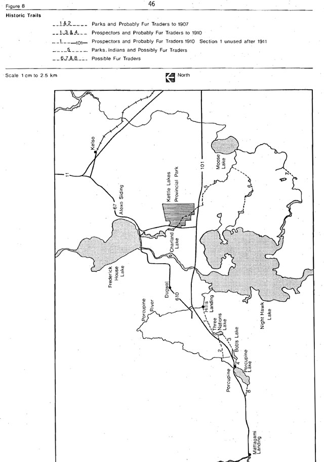
Access between Frederick House and Kenogamissi Post was accomplished by a series of water and land routes - either following the Porcupine Trail route from Hill’s Landing or utilizing the Porcupine River to its headwaters at Porcupine Lake and travelling overland to the Mattagami River. Competition between the North West Company and Hudson’s Bay Company became intense and mutually unprofitable and by 1821 very little remained of the trading post network in the area (Figure 8).
Figure 7: Fur Trading Posts 1776-1821
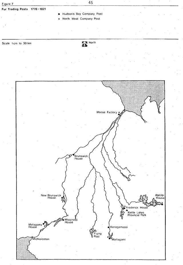
Figure 8: Historic trails
6.3 Mining
The first real discovery of gold in Ontario’s Precambrian Shield came in 1866 at the Richardson Mine near Madoc. The first hint of the vast wealth of the Sudbury Basin came in 1883 during the construction of the Canadian Pacific Railway. Yet, it was only at the beginning of the present century that the opening of the silver camp at Cobalt created any real interest in the potential mineral riches of Northern Ontario.
The first mining claim in the Timmins area was staked in May, 1905. The earliest ’1 bona fide discovery in the general Porcupine area was made in 1907 on Gold Island in Night Hawk Lake by two Finnish prospectors. By 1907, the Timiskaming and Northern Ontario Railway (T. & N. O.) had been pushed as far northward as Matheson. Prospectors began to swarm into the area. Great discoveries that year included the Dome Mine, which is still in operation today. In 1908-09 the Hollinger and McIntyre Mines were discovered, which set the pace for economic development in the Timmins area.
Such were the earliest developments in the saga of wealth that has made Timmins the centre of one of the world’s richest gold producing areas. There have been a great many other discoveries in the intervening years. Several of them have resulted in major mining enterprises, while others have been less fortunate.
The district centering on Timmins grew and prospered as more discoveries were made year after year, and more gold mines came into being. Porcupine Paymaster started up in 1922; the Buffalo-Ankerite in 1932; Coniaurum 1928 and the Pamour Mine in 1936. Delnite started in 1937, Preston East Dome in. 1936, Broulan Reef, Hallnor and Moneta were added in 1939. The Aunor went into production in 1940 and the Hugh-Pam in 1948. As is inevitable, all mines must eventually come to the point where the ore is so depleted that continued production is no longer economically possible. The Porcupine area is no exception, and by mid- 1968 only six remained in operation.
From time to time, prospectors in the area in their search for gold had come upon scattered outcroppings of copper and the presence of deposits had been indicated in geological reports. However, it was not until 1943 that any successful efforts were made to capitalize on this knowledge.
Early April, 1964, Texasgulf Inc. announced that it had discovered a major orebody about 24 km north of Timmins in Kidd Township. It must be said that the real estate boom that followed the discovery was of a spectacular nature. Also, in 1969, work started on -new refinery followed in 1976 with a start on a huge smelter complex still under construction.
Kettle Lakes Provincial Park is situated in the midst of what many geologists believe is one of the richest mineral concentrations in the province, “The Porcupine Camp”.
All aspects of life, whether economic, historical or cultural, reflect in some way, the mining theme. Our most interesting and colourful history involves the search for minerals in the Porcupine area. Still, today, the air is filled with yarns of early prospectors, the gold rush and speculation about when the next big find will be made.
6.4 Early settlement
During the period 1889-1905, surveys were conducted to determine the development of the Great Clay Belt. The last major colonization attempt in Ontario’s history was triggered by a proposed railroad to James Bay. In 1909, a railroad was completed to Cochrane from New Liskeard. With the railway tame settlers looking for agricultural lots.
Following the discovery of gold in Tisdale and Whitney townships, the T. & N. O. (Timiskaming and Northern Ontario Railway) was extended from Porquis Junction to Timmins and settlers moved into these adjacent townships (Ontario Lands and Forests, 1959).
The farm lots made available to the first settlers were approximately 160 acres in area and were usually well covered with merchantable timber. These lots were given to Boer War and First World War veterans for services rendered to the Crown. The first settlers probably took up land with enthusiasm but, with little knowledge of the difficulties that they would encounter. Some settlers were unable to endure the hardships of pioneer conditions, others took up land only for the timber thereon - having very little interest in farming.
In 1912, to provide some assistance to settlers, improvement loans and seed grain loans were made available. These were administered by the Northern Development Branch of the Department of Highways (Ontario Lands and Forests, 1959).
Some attempts at farming were made in the park area near Leg of Lamb Lake. However, all traces have been erased by the subsequent logging and forest fires.
Viable farming operations are located to the north and east of the park where the clay soils are more productive. Small subsistence and part-time operations are located in the Connaught area and to the west of the park.
6.5 Forest operations
Originally, the forest of Kettle Lakes Provincial Park consisted of mature stands of pines, which suffered major damage during the fires of 1911 and 1916.
Logging activity was common in the park area until about 1927. A small portable sawmill was located on the shore of Slab Lake which is now one of the day-use areas. This mill can still be seen in Connaught and is owned by a Mr. Seguin.
The “Coup de grace” was delivered in late 1927 when a forest fire swept through most of the remaining park timber. During the 1930s and ’40s, Kettle Lakes was used mainly as a source of firewood by the inhabitants of nearby Connaught. Gradually, post fire growth, such as poplar, white birch and jack pine reclaimed the fire scarred areas.
A major reforestation program was carried out from 1958-1972 and approximately one and one half million trees were planted. Minor plantings occur each year of large root stock and two or three thousand seedlings to infill small heavy use areas of the park.
6.6 Park development history
Due to its location and accessibility to the more populated areas, namely, Timmins, Iroquois Falls and Matheson, Kettle Lakes became an ideal recreational area for fishing, picnicking and camping. Cognizant of this recreational potential, the Department Of Lands and Forests.(now the Ministry of Natural Resources) established the area as a Provincial Park in 1955.
In 1956, work commenced at Kettle Lakes Provincial Park with the development of camping grounds and picnic areas, followed in 1957 with the construction of an office and warehouse building. Each year improvement projects have been undertaken and at the end of the 1963 season, 95 campsites and facilities for 200 picnic parties were available. Today, the pork has 167 campsites, comfort stations, an amphitheater, a shower and laundromat building, a store and several lakes geared for day-use visitors.
6.7 Area resources
A wide variety of local attractions are available to the inquisitive visitor to the park region The mining story of the Porcupine is best seen by taking one of the mine tours offered by Texasgulf, Pamour, Dome and McIntyre mines. Rock displays situated at several locations are more than enough to satisfy any rock hound’s curiosity. Historical sites and the museum in South Porcupine offer a glimpse into the area’s colourful history.
Logging operations can be visited in Iroquois Falls (Abitibi) and Timmins. (Malette Lumber, McChesney Lumber), while the Polar Bear Express based in Cochrane brings tourists to the last frontier in Ontario - Moosonee.
Finally, the area itself offers some of the most varied winter outdoor recreational opportunities found anywhere in the district.
The outdoor recreation resources for bathing, picnicking and camping are, however, in short supply in the Timmins area. There are very limited beaches and very few of these are open to the general public. The majority of lakes are small and very deep. Most large lakes are flooded water bodies which are very shallow, dangerous and turbid.
Kettle Lakes Provincial Park has more than 60 percent of the total available developed bathing areas within a 40 km distance of the centre of Timmins.
7.0 Environmental analysis
Kettle Lakes Provincial Park has the capability of providing a wide variety of recreational opportunities such as camping, day-use activities, canoeing, fishing, and backcountry and winter activities. However, an optimum level of development, based on recreational quality standards and environmental constraints must be reached beyond which it would not be advisable to develop.
7.1 Sensitive features
Water quality
Most of the park lakes are small, landlocked, having no surface inflow or outflow and consequently are entirely dependent upon rainfall and groundwater infiltration for recharge.
Soils
Erosion and soil compaction are two major obstacles facing campsite and trail development within the park. Most soils in the park consist of only a thin organic veneer overlaying sandy, well drained lower horizons. Erosion is pronounced on pathways and on slopes leading to most lakes. Gullying has been observed throughout the park, but most notably on slopes leading to Leg of Lamb, Boy Scout and Irrigation lakes.
Soil compaction in the park is most severe at Bullfrog, Island and Boy Scout lake campgrounds and, to a lesser extent, the trail system. Severe soil compaction and erosion usually result in an almost complete loss of the shrub and herbaceous strata from the area. Furthermore, the soil compaction has led to a substantial decrease in water permeability and an increase in root exposure resulting in mortality of numerous jack pine.
In order to alleviate these problems in the present and future campgrounds, campsite rotation will be necessary.
Faunal resources
The cold water trout fishery in the park is most sensitive to water quality change. Because this cold water fishery is not self-sustaining, it must be maintained on a “put and take” basis. Self-sustaining warm water fisheries in the park such as northern pike, bass and yellow perch are much less sensitive.
7.2 Significant floral features
With the possible exception of the clay plain mixed upland forest and the peatland cedar-spruce Kettle Lake bog, all floral associations represented in the park area are common to the district. Consequently, the value of natural communities in Kettle Lakes Provincial Park lies largely in their representation rather than in their uniqueness (Griffiths, MacDonald, 1977).
Described below are the locally significant floral communities found in Kettle Lakes.
Clay plain mixed upland forest
This association is found north of Mud Lake and represents a mature clay loam forest dominated by balsam fir and white birch in which trembling aspen assumes secondary importance. This is one of the very few sites in the park which has survived the 1927 fire and has been allowed to mature although has not as yet reached a climax stage.
Species diversity of this community is high as a result of considerable species richness and evenness of their distribution. The shrub stratum is well developed and supports a large variety of species including balsam fir, mountain maple, beaked hazel, ground hemlock and mountain ash. The transition of this balsam fir - white birch stand from a poplar-birch association to a climax spruce-fir forest is of considerable interpretive value.
Peatland cedar spruce forest
This association is found southwest of Mud Lake and represents a well developed, relatively undisturbed black spruce-white cedar forest. With the exception of a small stand on the north shore of Point Lake, this area is the only one in the park containing mature white cedars.
The importance of this community lies in its representativeness of a mature, undisturbed black spruce-white cedar forest which supports a forest bog flora including shinleaf, a species believed to be rare in the clay belt area.
Sand flat tundra - heath with black spruce groves
The distribution of this association in the park is restricted to an area of raised sandflats found along the park’s southeastern boundary. The area has been invaded by scattered black spruce which occasionally forms small impenetrable groves.
It is believed that this association represents a pot-fire succession stage following a burn of a black spruce-jack pine tundra site. The successional process leading to the formation of the present community has good potential interpretive value.
Wetland communities
The wetland component of the vegetation affords some of the best interpretive opportunities in the park. The best representative of lake shorelines and kettle bogs are briefly described below and their distribution is given in Figure 9.
Point Lake shoreline
The shoreline of Point Lake is highly diverse. Several communities adjoin the lake and include a black spruce-white cedar forest similar to that identified south of Mud Lake, a spruce heath tundra and a black spruce stand.
Mud Lake shoreline
The shoreline along Mud Lake is one of the most extensive and well developed in the park. It is believed that the marsh encircling the lake has been formed within the last few years as a result of beaver activity or possibly natural fluctuations in the water table. Typically, the plant community found here consists of a mixture of remnant bog species and invading marshy vegetation.
This extensive wetland area represents a significant habitat for waterfowl as well as mammals - including beaver and moose. The ongoing transition from a bog to a marsh community is of considerable interpretive interest.
Figure 9: Locally significant features
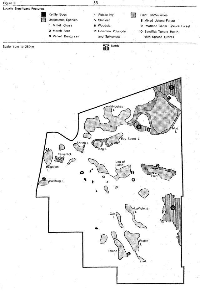
Keg Lake and Boy Scout Lake
A well developed flooded heath association joins the western portion of Boy Scout Lake to Keg Lake. The characteristics and values of this association are similar to those discussed for Mud Lake.
Spring Lake
The leatherleaf bog heath associated with the eastern end of Spring Lake represents one of the best developed marsh shorelines found in the park.
Tamarack Lake
This is the only circle bog lake in the park. Tamarack Lake affords an excellent opportunity to study vegetation patterns characteristic of downdrained shorelines.
Kettle bogs
The bogs found within the kettle depressions scattered along the esker are remnants of former glacial lakes. A typical kettle bog is composed of a quaking fibrous hummocky mat of peat composed of sphagnum moss and supporting a dominant cover of leatherleaf. Scattered within this mat are sundews, pitcher plants, irises, swamp laurel, bog rosemary and several species of sedges and grasses. Some of the more important bogs occurring in the park are shown in Figure 9.
7.3 Significant geological features
Kettle Lakes does not contain any geological features of regional or provincial significance.
The only features of district significance are the small, isolated bogs which provide typical representation of postglacial vegetational patterns (Figure 9).
7.4 Environmental concerns
Water quality
At present, the trophic status
Noise pollution
The absence of controls governing all terrain vehicles, tail bikes and snowmobiles does at times lead to conflicts between certain park users (e.g. noise in campsites). Also devices such as portable generators, chainsaws and stereo sets lead to conflicts among park users.
Winter ice fishing
Winter ice fishing is creating management problems in Kettle Lakes Provincial Park. It is believed that debris (wood, ash, oil, gas) left on lake ice during winter months may be contributing to water quality deterioration. Further, the primary purpose of the winter trout stocking program has been to increase the quality of fishing opportunities during the following summer park season. To date heavy winter fishing has reduced the effectiveness of this program.
Forests
Many of the 900,000 trees planted in the park over the last several years are affected with Scleroderris and sweetfern blister rust. Also the red pine and white pine are susceptible to winter burn and many stands of poplar are of poor quality due to the profusion of dry sites and the presence of the forest tent caterpillar.
Our of park influences
The possibility of airborne pollution exists from the Ecstall Mining refinery and smelter near Hoyle. Westerly winds are most common in the area and some airborne waste from the complex could be carried to the park area.
Beaver
Beaver activity around park lakes can at times cause damage to camping and dayuse areas.
7.5 Environmental carrying capacity
To ascertain the park’s ability to sustain use both land and water based carrying capacities are examined. The land based capacity is determined on the basis of the presence or absence of four elements: natural features, sensitive features, soil constraints and landscape constraints. The water based capacity on the other hand is measured on the basis of the trophic and bacteriological capacity of the lakes.
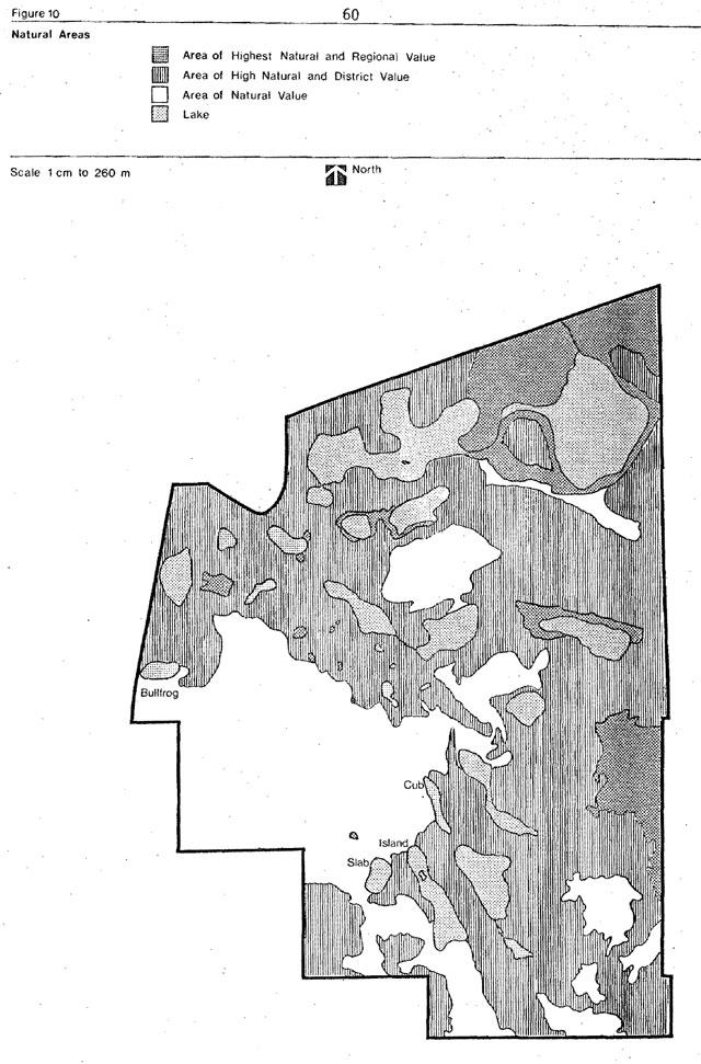
Natural/sensitive values
Figure 10 identifies areas of (1) highest natural and regional value, (2) high natural and district value and (3) natural value. Areas of highest natural values on a regional basis include the clay plain mixed upland forest and the peatland cedar-spruce kettle lake bog. Twenty-five areas exist of high natural value on a district basis. These include sand lands, clay plains, kettle bogs and kettle lake shorelines. Most of the remaining park area is classed as having natural value.
Figure 10: Natural areas
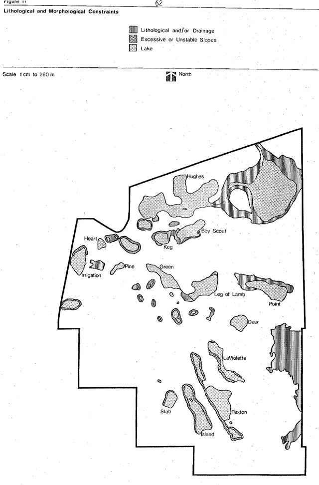
Soil constraints
Figure 11 identifies lithological and morphological constraints to development. The fine sand to course gravelly sand that composes more than three quarters of the park land surface is well drained and would provide a suitable base for most construction purposes. An excavation in these materials might encounter individual or clusters. Of erratic boulders whose large size could impose unexpected development costs and delays. The abrupt vertical and horizontal changes in dominant sediment grain size that characterize most of the esker and complex create the need for site specific sub-surface evaluations in any area of proposed development. Such testing could be in the form of deep augering or mechanical excavation.
Soil types unsuitable for development include the very find sand, clays and the saturated organic terrain of the bogs. Sands tend to shift once their thin soil cover is removed; clays have low permeability and the organic areas are often deep and their high moisture content create an unpredictable and difficult medium for construction activities.
Landscape constraints
Steeply sloping surfaces are mostly confined to the kettle lake basins. None of these areas can sustain extensive removal of the vegetative cover without rapidly deteriorating into gully development. Even trail development must be monitored carefully to evaluate its effect on erosion. These areas require particular maintenance to ensure the preservation of the high quality of the lakes in the park.
Figure 11: Lithological and morphological constraints
Trophic status
Most lakes in Kettle Lakes Provincial Park contain low (oligotrophic) to moderate (mesotrophic) nutrient levels.
Water quality scale
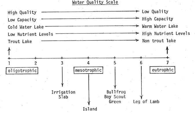
Over very long periods of time, natural process gradually transforms lakes from low nutrient concentrations (oligotrophic) to high nutrient concentration (eutrophic). This transformation process can be speeded up as a result of any one of a number of factors. In the case of Kettle Lakes, overuse would be the major contributing factor. As a result, it is imperative that existing and future use levels and water qualities be monitored to ensure that no major variations occur.
An examination of the existing trophic status, capacity and use of park lakes, reveals that Island and Bullfrog lakes are mesotiophic lakes, and have the capacity to sustain present use levels generated by campgrounds in their vicinity. Slab Lake on the other hand, with major day-use developments along a segment of its shoreline has an annual use ranging from 10,000 to 30,000 user-days. Continued use of Slab Lake at this intensity would result in its transformation from an oligotrophic to an eutrophic lake. Although Slab Lake has experienced this level of intensive use for 3 to 4 years, only very marginal water quality variations have been noted. To help rectify this overuse situation, day-use at Slab Lake will be phased out and a campground will be developed which will ultimately reduce the overall use of Slab Lake.
Table 6: Capacity and use of camping area lakes
| Campsite Development Existing |
Campsite Development Proposed |
Lake capacity1 | Lake use2 | Under or Overuse of lake1 | Projected Lake Use2 | Under or Overuse of Lake1 | |
|---|---|---|---|---|---|---|---|
| Bullfrog | 50 | 100 | 4,125 | 4,050 | + 75 | 8,000 | -3,975 |
| Island | 117 | 152 | 11,550 | 9,450 | +2,100 | 12,285 | -735 |
| Slab | - | 100 | 1,632 | -3 | - | 8,100 | -6,468 |
1expressed in user-opportunities
2determined by the following formula: (season length x 60% campsite occupancy x average person/party who swim)
3existing day-use on Slab Lake ranges from 10,000 to 30,000 user-days annually with increased campground development around Slab, Bullfrog and Island lakes, a slight deficit of camper day-use opportunities can be expected.
However, of these three lakes, Slab is expected to bear the heaviest camper use because of its highly attractive swimming and picnic area. Also, future emphasis will be placed on concentrating a major portion of camper day-use opportunities on Slab Lake, thereby centralizing possible water variation to one lake.
Lakes associated with existing and future day-use developments (Green, Irrigation, Point, Boy Scout, Hughes Lakes and Leg of Lamb) can on the basis of water quality analysis accommodate both existing and projected future day-use. The present and future strategy for day-use in Kettle Lakes is to decentralize use over a number of lakes as opposed to concentrating use to just one or two lakes. Existing day-use annually averages 12,000 user days while the park has been developed to accommodate 20,849 user-days. When required, future expansion of day-use facilities will concentrate on Boy Scout, Hughes and Leg of Lamb. Combined these three lakes can more than triple the day-use capacity of the park. Pexton and Slab lakes will be phased out as day-user lakes.
Table 7: Lake and beach capacity of day-use area lakes
| Beach Capacity* Existing |
Beach Capacity* Projected |
Lake Capacity** | Surplus Lake Capacity*** Existing |
Surplus Lake Capacity*** Existing |
|
|---|---|---|---|---|---|
| Green | 7,679 | 7,679 | 10,804 | + 3,125 | + 3,125 |
| Irrigation | 3,686 | 3,686 | 3,744 | + 58 | + 58 |
| Point | 3,190 | 3,190 | 22,000 | + 18,810 | + 18,810 |
| Boy Scout | - | 732 | 9,052 | - | + 8,320 |
| Hughes | - | 58,542 | 78,000 | - | + 19,458 |
| Leg of Lamb | - | 19,140 | 19,600 | - | + 406 |
| Slab | 4,839 | - | 1,632 | - 3,207 | - |
| Pexton | 1,455 | - | 11,000 | + 9,545 | - |
| Total | 20,849 | 93,023 | 155,832 | + 28,215 | + 50,069 |
*based on the physical capacity of the beach to sustain use nad measured in annual number of opportunities
**optimum number of user opportunities which a lake can accomodate
**determined by subtracting beach capacity from lake capacity
Bacteriological capacity
At present levels of use on Slab, Bullfrog, Island and Green lakes, bacteriological concentrations are considered to be very low. With a 100 percent increase in use of Bullfrog and Island lakes, bacteria densities will increase but not surpass the acceptable levels for total coliform, fecal coliform and enterococcus of 1000, 100 and 20 per ml respectively. In the case of Slab Lake, fecal levels should improve with proposed reduced use.
Summary
Although, the trophic status of Slab Lake may slightly vary in the future, bacterial concentration will be monitored to ensure that it remains within acceptable limits for water contact recreational activities.
8.0 Park policy
The Kettle Lakes landscape has evolved over many thousands of years through the complex interaction of natural forces. Early man left little evidence of his hunting, fishing and food gathering in the park.
Presently, the landscape provides a variety of recreational opportunities. The following policy statements provide direction for the conservation, management and development of the park resources.
8.1 Park goal
To provide a wide range of intensive year-round recreational opportunities with an urban oriented park of recreational and outdoor education significance.
8.2 Park objectives
Camping
To annually provide 54 000 camper-day opportunities for provincial and non-resident use.
Day-use
Summer
To annually provide 35,000 user-days of swimming and picknicking opportunities and 60,000 user-days of hiking, walking, bicycling and fishing opportunities.
Winter
To annually provide 25,000 user-days of quasiintensive winter day-use opportunities such as cross-country skiing, snowshoeing and snowmobiling.
Visitor services
- To provide personnel, programs, media and facilities to aid the visitor in recognizing, using and enjoying the full recreational, interpretive and educational potential.
- To explain the various resource management practices present within Kettle Lakes Provincial Park and the par region.
Development
To construct sufficient park facilities to support the quality and quantity of opportunities to be provided.
8.3 Park name and classification
The name Kettle Lakes Provincial Park will remain in recognition of the numerous kettle lakes which cover the park area.
Kettle Lakes is designated a Recreation Park in accordance with the Ontario Provincial Park Classification System. Kettle Lakes is well suited as a recreation park because it provides day-use and camping opportunities to a large local population. In this respect, the park fulfills the leisure needs of local residents as well as provincial and out of province visitors.
9.0 Management policies
The following management policies are designed to help achieve park objectives.
9.1 Fish and wildlife
Hunting
Hunting will not be permitted in the park to ensure the safety of the general public and to maximize wildlife viewing opportunities.
Wildlife management
Where possible, wildlife management practices will be pursued to provide wildlife viewing opportunities. Stocking of game will not be permitted and wildlife specimens may be taken for scientific purposes only under written authority of the Ministry of Natural Resources.
Only the trapping of beaver on a highly controlled basis will be permitted within the park. Nuisance beaver problems are a constant threat to access roads and deciduous tree screens around campsites.
Rather than depend on an unreliable system of responding to individual problem animals, sufficient trapping pressure will be used to maintain levels as prescribed in the wildlife management plan. Enough animals will be allowed to inhabit the development zone so that park visitors will be able to see beaver workings. This trapping policy will be implemented by designating Kettle Lakes Provincial Park as a separate trapping area subject to intensive management control. The Park Superintendent will convey to the District Fish and Wildlife Supervisor on an annual basis all relevant concerns regarding specific trapping controls. These concerns will then be passed on to the trapper in writing and he will be required to comply.
Black bears which enter campgrounds will be removed immediately. The animals will be live-trapped or drugged with a tranquilizer gun and removed from the park. These bears will be marked with paint and ear-tagged. Paint marked or tagged animals which return to camping areas and nuisance bears that are difficult to live-trap or tranquilize will be destroyed.
Fishing
The present fisheries management plan will be reviewed every five years. Incorporated in the plan are strategies to maintain a quality fishery consistent with the objectives of the park. High quality trout lakes will be maintained where possible by means of approved management practices. Other lakes not suitable for a trout fishery will be used for the introduction of native warm water species.
The fisheries management plan provides direction for winter and summer fishing and fish stocking practices.
9.2 Vegetation management
Forest harvesting
There will be no harvesting of timber within the park. Trees may be cut for recreational development purposes, aesthetics, safety and therapeutic reasons, and marketed if economic. Therapeutic cutting may be permitted to eliminate a disease or a pathogen infestation.
No cone collection will be allowed within the park.
Planting
Planting of native tree species will continue where needed. The vegetation management plan will be reviewed every five years to ensure maintenance of the best species for shade, buffers, erosion control, aesthetics, and other possible uses.
Forest insects and disease
Aerial release spraying (e.g. deciduous elimination to promote evergreen growth) will not be allowed in the park. Pathogen spraying will not be permitted unless the park area is seriously threatened by insect or disease and then only under the auspices and guidelines set out by the Ministry of Natural Resources and the Ministry of the Environment.
9.3 Fire management
Prescribed burning as a means of regeneration will not be permitted. Wildfire will be extinguished; the present system of fire protection will continue. This will include staff training, regular maintenance of fire equipment and fire roads and staff reviews of the park evacuation plan. No campfires will be allowed in the park when a fire warning has been posted. At other times campfires will only be permitted in approved areas. The park evacuation plan will be reviewed every two years.
9.4 Lands
Land management
All lands within the park are now reserved under the Provincial Parks Act. Surficial extraction will not be permitted except for limited park purposes.
9.5 Environmental quality
Biocides
Application of biocides will not be permitted except by individuals for personal use and in acceptable quantities, and for lake reclamation under the auspices of the Ministry of Natural Resources and the Ministry of the Environment.
Water quality
The water monitoring program will be continued to ascertain variations in water quality. Special attention will be given to developed lakes within the park.
Utility corridors
Non park related utility corridors will not be allowed.
9.6 Visitor services
Educational and recreational programs will be initiated by park visitor services staff. This same staff will relate management messages to park patrons through a variety of ways, e.g. publications, audio visual programs, films, exhibits, guided walks, personal contacts, et cetera.
Programs and facilities developed will be consistent with the regional and district visitor services plans.
9.7 Waste disposal
Ministry of the Environment standards for waste disposal will apply. Park user solid waste and sewage will be disposed outside the park.
9.8 Visitor safety and public health
Ministry of Natural Resources and Ministry of Health standards pertaining to visitor safety and health will be observed and maintained.
9.9 Other management guidelines
Handicapped visitors
Recreational facilities will be developed in specific areas to accommodate handicapped visitors (e.g. ramps to building entrances, showers, toilets, and trails for the handicapped.)
Edible plants
Harvesting of edible plants will be allowed by park users. However commercial operations will not be allowed.
Motorized vehicles (all-terrain vehicles)
All motor powered machines (snowmobiles, motorcycles, all-terrain vehicles) will be regulated and/or restricted to areas and zones compatible with their use. In all cases this will only be park roads. Unlicensed units will not be allowed to operate within the park.
Motor-powered boats shall not be used on park waters except for emergency aid or essential park functions by Ministry staff.
9.10 Park management and operating plan
Upon approval of this master plan, a park management and operating plan will be compiled. This plan will provide full and detailed information on operational and management functions of the park. The content will include information on personnel, safety, financial management, park maintenance, facility operations, visitor services, law enforcement and security. The plan will contribute to efficient and effective internal administration and will provide quality services to the public.
10.0 Park zones
There are five possible zones in a recreation park: development, natural environment, nature reserve, historic and access. In Kettle Lakes Provincial Park, the zone designations applied are the development, and natural environment (Figure 12).
10.1 Natural environment zone
Nine natural environment zones have been delineated in the park covering an area of 270 ha.
Contained within these zones are clay plain mixed upland forest, the peatland cedar-spruce kettle lake bogs, aquatic offshore communities and kettle lake shorelines.
These zones provide opportunities for extensive, non-facility dependent recreational activities. Development will be limited to trails (fitness, walking, bicycle, exhibits, shelter and blinds).
10.2 Development zone
The development zone in Kettle Lakes encompasses an area of 991 ha and includes all existing development areas and all areas where development is proposed. To date, day-use and camping activities have been interspersed. In the future they will be segregated wit in the park.
Campsites with electrical outlets and group camping facilities will be provided. Limited modifications may be made to the landscape to permit higher levels of use.
The removal of diseased and hazard trees may be required in this zone. Similarly trees may be removed for facility development. Lake reclamation and fish stocking will be permitted. Tests will be taken during peak use periods to monitor against water degradation. These tests will be comparatively analyzed from year to year so as to detect any trends in water quality.
Figure 12: Zoning
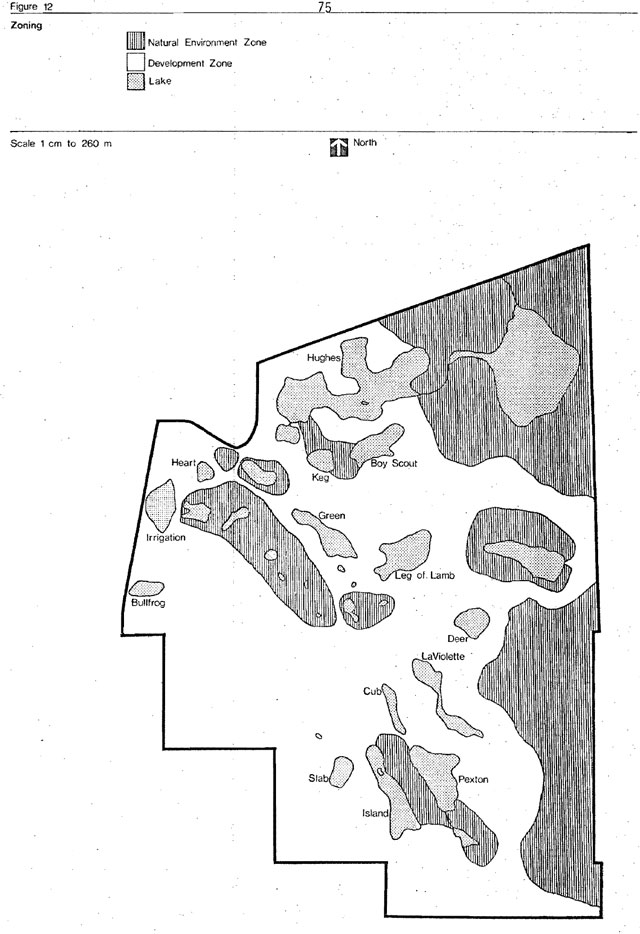
11.0 Visitor/resource relationship
11.1 Visitor services
The master plan has identified park resources, their sensitivity -and significance - and made suggestions regarding their management.
Park resources can be experienced on-site or vicariously. Visitor services will help to promote a user-resource relationship by communicating the park to the visitor. The visitor services goal for Kettle Lakes Provincial Park is to aid the people of Ontario and its visitors to obtain optimum benefit and enjoyment from Kettle Lakes and to ensure public understanding and Support for the management objectives and programmes of the park. The visitor services programmes will be fully integrated with all other park functions and operations in order to provide the optimum level of service. Visitor services is composed of four components: information, interpretationrecreation and outdoor education. All four are present to some degree in every provincial park; the degree depending on park classification, provincial and regional visitor services plans and other park region values and influences.
For Kettle Lakes, the information, outdoor education and recreation programs have high potential.
Interpretive program
The objective of the interpretive program is to offer interpretive opportunities to park visitors through self-use media and facilities, and organized activities.
Interpretive opportunities for visitors include traditional organized activities, such as, guided hikes and evening programs. Future emphasis will be placed on self-use trail facilities.
Self-use trail facilities appealing to the visually handicapped and those with special interests in geology and hiking will be used to relate interpretive messages at Kettle Lakes.
The park brochure and trail guides are, at present, the only interpretive publications at Kettle Lakes; however, two new trail guides are being prepared along with several other publications to convey interpretive messages to park visitors.
A visitor centre is planned for Kettle Lakes. It is expected that this centre will become the focal point for park interpretation. Displays will be an important interpretive component in this centre.
Recreation program
With regard to recreation, visitor services at Kettle Lakes will be responsible for: (a). providing input to decisions on the recreational facilities to be provided in the park; (b) planning and programming staff-organized recreational activities in the park.
Outdoor recreation is defined as: all those outdoor activities which individuals or groups choose to engage in during free or leisure time to satisfy social, physical, intellectual or emotional needs.
The greatest flexibility for facilities is required at Kettle Lakes Provincial Park. Facilities such as horseshoe pits, lawn sports, courts, baseball backstops, indoor activity centre and creative play areas will be considered. At present, the only recreational facilities available in the park are a fitness trail and cross-country ski trails.
Programming (staff-organized activities), on the other hand, will be developed with the following in mind:
Since Kettle Lakes is classified as a recreation park, recreation programming will be much broader in scope than in other classes of parks. By definition, this classification is intended to provide opportunities for a variety of intensive year-round activities, be reflective of and adaptive to changes in outdoor recreation behaviour.
There is still a requirement, however, to programme within the criteria suggested above, some activities like jogging, exercising discussion groups, painting, photography, theatre, puppetry, music, art creative play, sleigh rides, recreation hall activities will be considered for Kettle Lakes. The campfire program is the only activity of this kind now present at Kettle Lakes.
Priority will be given to evolving a system of programmes for the development of knowledge and skills associated with the outdoors. Typical activities will include camping skills associated with the outdoors such as canoeing, cross-country ski tours, hunting safety, wildlife identification, hiking skills, backpacking. At present, Kettle Lakes offers such programs as orienteering, bush skill demonstrations (axes, knives, survival gear), wilderness cooking and children’s programs. These programs relate directly with such parks as Wakami Lake, Polar Bear and Missinaibi Provincial Park.
11.2 Outdoor education program
Visitor services at Kettle Lakes will aid school groups in making optimum use of the park system for outdoor education. Aid will be provided in a manner compatible with our management policies, the students’ curricula and provincial policy.
At the present time, our assistance consists of providing:
- Resource Information packages,
- Guidance when planning field trips,
- Organizing field trips,
- Lectures and slide presentations on area and park resource at the local schools,
- Teaching of various outdoor recreation skills, (e.g. orienteering, survival)
Presently, our assistance is limited to providing teachers with a limited outdoor education program. However, future policy may well lead to much greater involvement as the full potential of the park system is recognized by educators.
Information program
Objectives of the information program are to inform park visitors about park and nearby area resources, facilities, services, programs and regulations and to provide necessary information to the local communities and media. Finally, visitor services will provide means by which people can communicate their comments to management and receive an appropriate response.
The communications program at Kettle Lakes consists of publications, word of mouth, signs, exhibits, audio-visual and slide presentations, personal contact (between visitors and park staff) and messages using the mass media. The park leaflet contains basic information concerning park resources, facilities, services and programs. Distribution points consist of the district office, other provincial parks in the northern region, local Chamber of Commerce and the park office. Other information (visitor services programs, etc.) may be obtained from cluster areas within the park.
Publications and audio visual presentations inform visitors of park rules, camping policies and related information.
Prime contact points for information dissemination will be the park gatehouse and in the future the visitor services building. When these contact points are inoperative, several information boards are available containing the park map, park rules, visitor services program and leaflet dispensers at the park gate, the concession area and the shower building. Similar information boards will be located at the comfort stations, beaches, parking areas or elsewhere as required. The feasibility of establishing a park radio station could also be looked into.
11.3 Other visitor services functions
The Regional Visitor Services Plan recommends that Kettle Lakes Provincial Park operate a major seasonal activity program. The program will require one regular staff member, a major building and support facilities, and a moderate seasonal staff (2 - 3) It will provide high quality, year-round activities and programs emphasizing both personal and media contacts.
12.0 Development
No simple formula exists for future development at Kettle Lakes. Topography, access, lake size, present use patterns and development, stress the need for alternatives in the planning process. Several development concepts were investigated which reflected varying potentials for recreational development. Based upon lengthy investigations, discussions and responses from the public, it was decided that the park would be divided so as to separate day-users from the camping population. Access to dispersed recreational opportunities would also be provided to these two different user groups. (Figure 13) The system will also facilitate the closing of park units when the need to do so is indicated. Environmental capacities and constraints have been taken into consideration for all proposed development especially the possibility of marginal water quality deterioration as a result of increased campsite development.
12.1 Campgrounds
Presently Kettle Lakes is able to provide 40,080 camper days of opportunity based on a one hundred day season and assuming a 60 percent occupancy rate.
The same capacity formula indicates that 150 campsites would be needed to provide an additional 24,000 camper days of opportunity during a regular park season. However, to safeguard against campsite deterioratio due to over-use, an additional fifty sites should be constructed over and above the 150 to allow for campsite deterioration.
Figure 13: Development concept

Campsite density will not exceed ten sites per hectare. Each campground will have a central play area.
Of the 200 sites 50 will be located at the existing Bullfrog Lake campground and will be non-electrical. One hundred will be located in the Slab Lake area and 50 in the Island Lake area. The number of electrified sites will be based on an analysis of user demand at the time of construction. During redevelopment at Slab Lake, the day-use area will be phased out. An extra 100 meters of beach will be constructed at Island Lake while the Slab Lake and Bullfrog beaches will be designated as camper beaches.
12.2 Day-use (picnic area)
Presently Kettle Lakes can provide approximately 20,849 user-days of opportunity for day-use activities such as swimming and picnicking. Several development concepts exist reflecting varying potentials for this type of development. However, following the strategy already discussed in this plan day-use development will occur in the north section of the park. Day-use facilities at Green Lake will be redesigned in conjunction with development of day-use facilities on Leg of Lamb.
Good beach potential exists along the north shore of the lake. Once the new beach area is completed Slab Lake will be phased out as a day-use area. A playground tennis courts and an open multi-use playfield are proposed in the vicinity to the day-use development.
Since the dry beach calculations seem to reflect the best patterns of use, it is estimated that an additional 300 meters of beach will be necessary to produce the required number of user days (Figure 13).
12.3 Trail development and associated facilities
Recreational activities, such as, hiking, fishing, and canoeing, play an important role in the recreational experience of most visitors in the park. An additional 30 km of trails is proposed for the park area. Once developed, these trails will provide an additional 30,000 user days of opportunity (Figure 13).
12.4 Winter facilities
Winter use presently consists mainly of snowmobiling, snowshoeing, and cross-country skiing. Demand for winter recreational activities is increasing rapidly in the area. The long range goal is to provide additional user-days of opportunity and facilities depending on demand and availability of funds. At present the park has approximately 12 km of cross-country trails, a wax shack, two privies and one picnic shelter available for lunch stops while skiing.
12.5 Access roads
The present granular and tar base roads will be replaced by an asphalt surface to overcome dust and washboard problems. Priority will be given to the road leading to Island and Green lakes. Also, all future paved road construction within the park will include side lanes reserved for bicycling. Also, all non-essential one lane roads will be closed to regular traffic and be converted to walking or bicycle trails. Road closure may be necessary, especially in spring, for road maintenance purposes.
12.6 Visitor services centre
A multipurpose visitor services building along with an outdoor theatre will be constructed. Support staff, equipment and facilities will be provided according to the staffing schedule included in this plan.
12.7 Utilities service area
At present the main utilities service areas are located at Pine Lake and on the north side of Bullfrog Lake. Hydro lines also enter the park in five different areas. All service areas will be redeveloped to fit the planning strategies as outlined in this master plan. This will include such things as:
- central metering of hydro service,
- all services utilities areas grouped in one section,
- underground services (hydro, water) will be preferred.
Phasing and development descriptions
Phase I
| Priority | Description |
|---|---|
| 1. | Bullfrog Lake campground rehabilitation, site planning and redesign for 50 additional sites (non-electrical), expansion of wet and dry beach and provision of parking area for additional vehicles. |
| 2. | Construction of one Type 9 comfort station with shower extension at Bullfrog Lake campground. |
| 3. | Relocation, redesign and construction of a new park maintenance complex and living quarter facilities (includes parking areas, landscaping, etc.) |
| 4. | Expansion of day-use facilities at Green Lake including construction of one Type 9 comfort station. |
| 5. | Changeover to central metering including primary line relocations. |
| 6. | Extension of hydro line to Green and Leg of Lamb lakes to service comfort stations and junior ranger camp. |
| 7. | Design and construction of a new park entrance complex to accommodate a separation of day-use and camping area. (This will include three lanes, new control booth, new entrance logo, etc.) |
| 8. | Design and construction of playground complex in the Slab-Island lake areas. |
| 9. | Relocation, design and construction of a new park amphitheatre. |
| 10. | Design and construction of 6 km of bicycle trails (used as cross-country trails in winter). |
| 11. | Design and construction of a hiking trail in the Mud Lake area. |
| 12. | Upgrade the Point and Irrigation Lake day-use areas. |
Phase II
| Priority | Description |
|---|---|
| 1. | To design and construct 150 campsites in the Slab-Island Lake area, along with associated facilities. The percent of electrified sites will be based on an analysis of user demand at the time of construction. |
| 2. | To construct a Type 9 comfort station at Leg of Lamb Lake day-use area. |
| 3. | To upgrade and pave 7 km of park roads leading to Island Lake and Green Lake. |
| 4. | To construct a new visitor services multipurpose centre. |
| 5. | To design and develop one new nature trail and one outdoor exhibit. |
| 6. | To design and develop 6 km of bicycle trails (to be used for cross-country skiing during the winter). |
| 7. | To upgrade the road system leading to Pexton Lake. |
Phase III
| Priority | Description |
|---|---|
| 1. | To redesign and upgrade the facilities of the park concession (store). |
| 2. | Relocation of the group camping area from Boy Scout lake to Slab Lake. |
| 3. | Redevelopment and upgrading of the Hughes Lake day-use area. |
| 4. | To design and develop 6 km of bicycle trails (used as cross-country trails during winter). |
| 5. | To design and construct one outdoor exhibit. |
13.0 Park operations and management
13.1 Staffing
All park staff members must be knowledgeable of the park goal and objective, particularly as they relate to management of park resources.
Similarly, park staff must be trained to carry out resource management strategies as outlined in this plan. The existing and proposed staff structure in Kettle Lakes Provincial Park is:
| Present | Phase I | Phase II | Phase III | Total | |
|---|---|---|---|---|---|
| Complement | |||||
| Park Superintendent | 1 | 1 | |||
| Assistant Park Superintendent | 1 | 1 | |||
| Maintenance Foreman | 1 | 1 | |||
| Park Warden | 1 | 1 | |||
| Visitor Services leader | 1 | 1 | |||
| Total | 3 | 1 | 1 | 5 | |
| Seasonal | |||||
| Maintenance Foreman | 1 | 1 | |||
| Maintenance Worker | 4 | 2 | 2 | 2 | 10 |
| Maintenance Mechanic | 1 | 1 | |||
| Maintenance Carpenter | 1 | 1 | |||
| Washroom Cleaner | 2 | 2 | 2 | 6 | |
| Park Clerk | 1 | 1 | |||
| Gate Attendant | 2 | 1 | 3 | 6 | |
| Traffic Control at Gate | 2 | 2 | |||
| Security Officer | 1 | 1 | 2 | ||
| Assistant Visitor Services Aid | 2 | 2 | |||
| Total | 9 | 9 | 10 | 4 | 32 |
In addition, there will be 25 to 30 students working in the park on the Experience program during all three phases.
Park superintendent
A park superintendent’s primary responsibilities are to supervise operations, management and development of park resources according to the park master plan and to ensure park objectives are attained through staff awareness of management guidelines and proper staff training.
Assistant park superintendent
An assistant park superintendent will assist the park superintendent in the operations, management and development of park resources.
Maintenance foreman
A maintenance foreman will supervise operational maintenance and assist in improvement and development projects under the direction of the superintendent and assistant superintendent.
Park warden
A park warden will assist and supervise in the operations, management and development of the park security program under the direction of the superintendent.
Visitor services leader
The visitor services leader will organize and carry out a visitor services program under the supervision of the park superintendent that is in accordance with the park visitor services plan and the master plan.
13.2 Park services
Water supply: Kettle Lakes primary water sourcesare three drilled wells located near Bullfrog, Slab and Island lakes and one pumping station located on the shore of Spring Lake. Water quality standards and usercapacities have been identified for these areas as to maintain existing water quality standards. Water quality testing is carried out by the park staff and sent to the Ministry of Health lab for analysis every week. All future water projects will have well systems as their sources.
Electricity
Five hydro transmission lines deliver power to the park office, maintenance and staff buildings, comfort stations, shower building, water pumping systems and eighty-three campsites. Both surface and underground lines are located in the Bullfrog, Island and Spring lake area. An extension of 3 km and 2 km is planned for Green and Pexton lakes.
Communications
Telephone service is provided by Northern Telephone Limited. The park has two units within the park. These are situated at the store, park office and the superintendent’s residence.
Radio communications are provided through a network of radio links consisting of one base station at the park office and two mobile units. Communications are also possible with the Ontario Provincial Police via a special channel on all radios.
Fire protection
Fire suppression within the boundaries of Kettle Lakes and surrounding Crown land is the responsibility of Fire Control at the Timmins District office. In the event of a fire blocking the park entrance, two emergency exit roads can be used to evacuate park visitors if the need arises. The park evacuation plan is reviewed with park staff and a fire-fighting training course is held annually.
Emergency services
The Ontario Provincial Police detachment office is located in South Porcupine (27 km).
Ambulance services are available from Timmins (38 km), Iroquois Falls (25 km) and Matheson (35 km).
Hospital services are available in South Porcupine (27 km),Timmins (38 km) and Iroquois Falls (25 km).
Sanitary facilities
The Ministry of Natural Resources and the Ministry of Health standards regarding public health are being followed.
Rowdyism and vandalism control
Problems of rowdyism and vandalism will be dealt with by control programs stressing education and public contact by all staff. Enforcement will be carried out as required by designated park wardens and the Recreation Control Officer, with backup in difficult situations by the South Porcupine Ontario Provincial Police detachment, who are in 24 hour radio contact with the park.
13.3 Park operating plan
A park operations plan is presently being prepared; It will contain more detailed financial management and park maintenance requirements.
13.4 Park visitor services plan
A park visitor services plan does exist for Kettle Lakes. It contains more detailed information concerning programming, financial management, maintenance and facility requirements. This plan will be reviewed and updated every five years.
13.5 Park enforcement plan
A park enforcement plan is available for Kettle Lakes. It contains detailed information concerning enforcement problems, staff training and manpower distribution.
14.0 Program implementation
14.1 Monitoring
This master plan will be reviewed every five years following approval by the Minister. Data collection and assessment will be conducted regularly to detect environmental variations.
14.2 Development
As user demand and funds permit, future park developments will be carried out in accordance with the phasing program identified in this plan. Each phase must be completed before the next phase begins.
14.3 Wildlife management
After approval of this plan, the park area is to be withdrawn from trapline #44 and established as a separate wildlife management area.
The park superintendent will be responsible for conveying to the District Fish and Wildlife supervisor, on an annual basis, management proposals related to the management area. An example of one such management proposal would be the trapping of nuisance animals.
14.4 Fisheries management plan
The fisheries management statement which appears in this plan is a précis version of a more detailed plan to be completed in the near future.
Resource management plan summary
15.0 Vegetation management plan
To achieve the resource management objectives of this plan, the following goal and objectives are put forth.
15.1 Goal
To maintain a natural vegetation resource that will be beneficial to both short and long term recreational and educational needs.
15.2 Objective
To protect and manage the vegetation resource so as to enhance recreational, interpretive and wildlife viewing opportunities.
15.3 Management strategies
- Therapeutic cutting, hazard tree removal and tree planting will be the principle management strategies used in the park campgrounds.
- A long term campsite rotation cycle will be implemented to permit vegetation rehabilitation processes to take place.
- A 10 year planting plan for the park will be prepared and will emphasize the maintenance of the park’s conifer understory.
16.0 Wildlife Management Plan
16.1 Objective
To outline policies and procedures that will be used to manage the wildlife resources within Kettle Lakes Provincial Park in accordance with the environmental, recreational and educational objectives of the park. All management programs will be consistent with the policies for recreation class parks in the Ontario. Provincial Park Planning and Management Policies.
16.2 Management strategies
The following management strategies will be utilized to manage the wildlife resources of the park •.
- No hunting will be permitted.
- Habitat improvement projects will be encouraged to retain and attract fauna traditionally associated with the park.
- The park area will be removed from its registered trapline status and all trapping will cease with the exception of nuisance species or populations out of control.
- Scientific study and research will be encouraged where conflicts do not arise with the park objectives.
- Wildlife viewing will be encouraged.
- Wildlife management interpretation will be encouraged
17.0 Fisheries Management Plan
17.1 Objective
To outline necessary fisheries management practices that will provide park users and local residents with a quality recreational sports fishery within the boundaries of Kettle Lakes Provincial Park.
17.2 General management strategies
The park lakes that are capable of supporting sport fish are divided into two broad categories:
- Lakes best suited to the production of warm water species (bass, perch, pike, pickerel).
- Lakes best suited to the production of cold water species (brook trout, rainbow trout).
The lakes categorized for warm water species are listed below:
- Island Lake
- Hughes Lake
- Mud Lake
The lakes categorized for cold water species are listed below:
- Green Lake
- Heart Lake
- Irrigation Lake
- Leg-of-Lamb
- Deer Lake
- Slab Lake
- Pine Lake
- Bullfrog Lake
Cold water species management: The lakes designed for the production of brook trout will be further categorized as:
- Put and delayed take lakes
- Put and take fisheries
The put and delayed take fisheries will be select on the basis of water fertility (TDS 60 ppm+).
The put and take fisheries will be on lakes with water quality capable of maintaining trout for various periods but with poor trout growing potential (TDS 59 ppm ).
The put and delayed take lakes will be stocked with young fish (3-6 months) to utilize the productive capabilities of the water, at a rate consistent with the lake size.
The put and take fisheries will be stocked with catchable sized fish at a rate that will give an angler success rate of 2 fish per angler day.
The stocking schedule will be arranged to maintain the success rate throughout the summer season.
Irrigation Lake will be used for the production of Rainbow Trout and will be stocked at rates consistent with the lake size and production potential.
General Recommendations: A creel census program will be carried out at regular intervals to determine the success rate of anglers and the return from hatchery stocking.
Reclamation projects will be carried out to maintain acceptable production rate in the put and delayed take lakes.
Appendices
Appendix 1
The calculation of lake capacities in development zones of provincial parks has long been a problem. This problem is further accented when one considers kettle lakes which are spring fed and have small surface acreages. Such lakes are very prone to deterioration in water qualities and, therefore, maintaining their water quality is of utmost importance.
In the Northern Region this problem is particularly acute where ten provincial parks and park reserves are situated on esker and outwash systems. Already, five of these park areas have park development concentrated around Kettle Lakes.
Essentially, then, a formula is required which allows planners to determine and compare a lake’s optimum annual user-day capacity to the backshore capacity which in turn allows for the computation of environmentally sound levels of development..
The methodology outlined here is the method currently being used by Northern Region planners. It is basically a modification of a water quality index formula currently used by Land Use Co-ordination Branch, Ministry of Natural Resources in its lake planning manual (1976). The following description excerpted from the manual best describes this methodology.
A lake’s water quality is defined here in terms of its trophic status. A lake’s trophic status depends on the amount of naturally occurring nutrients available to stimulate biological activity. Human development may significantly increase the quantity of available nutrients. On the other hand, natural nutrient input may be so great that human activity would cause a negligible increase. Thus, the more productive (eutrophic) lake is, the more natural nutrients are available and the more human activity it can sustain without drastically lowering its trophic status. At the same time a biologically productive lake is less attractive for contact recreation.
Determining the existing water quality of a lake will therefore indicate the sensitivity of the lake to the addition of nutrients through human activities. The water quality is classed and ranked according to an aggregate of six water quality parameters. The rank will indicate its existing trophic status and thereby determine the amount of use the water can sustain while remaining at approximately the same trophic level. The number of user-days that specific quality can sustain without deteriorating has not been proven, but the estimate is thought to be conservative. Furthermore, in the absehceof historical information on a lake’s water quality, the index cannot indicate whether the water quality is due to natural influences or due to human development. To determine the Water Quality Index, these steps should be followed:
- Look up the recorded information for each parameter and relate it to the score tables for each measurement.
- When the score for each parameter has been noted, add these to get the aggregate score.
- The aggregate score will indicate the lake rank according to the Water Quality Index.
- The water. Quality Index can then be interpreted into an allowable figure of use, given in user-days/ha/year.
- To obtain the total use capacity for the lake, multiply the number of user-days/ha/year as dictated by the rank times the gross hectares, i.e. user-days/ha/year X gross hectares = total user days.
Further:
- Iron/phosphorous ratio is only relevant under anaerobic conditions.
- If either the secchi disc or chlorophyll parameters are unavailable, they can be estimated from the Vollenwieder curve.
- In some cases, lake survey forms will give no T.D.S. readings but rather conductivity readings. A conductivity/T.D.S. conversion chart is indicated in the manual for such cases.
- If any other parameter is unavailable, the index may be used, but the results will be considerably more conservative in terms of the real capacity and the degree of confidence that can be afforded the index will be somewhat limited (Lake Planning Manual, p 61).
Water Quality index - score tables:
Mean Depth
| Distribution | Score |
|---|---|
| 0 - .9 metres | 10 |
| 1 -1 .9 metres | 8 |
| 2 - 3.9 metres | 6 |
| 4 - 7.9 metres | 4 |
| 8 - 14.9 metres | 2 |
| 15 + metres | 0 |
Oxygen Distribution
| Distribution | Score |
|---|---|
| Clinograde and anaerobic conditions | 10 |
| Melolimnetric maximum and hypolimnion depletion | 8 |
| Metalimnetric maximum | 6 |
| Clinograde | 4 |
| Orthograde | 0 |
Chlorophyll a
| Distribution | Score |
|---|---|
| 14.1 – ug/l | 10 |
| 9.1 - 14 | 7 |
| 4.1 - 9 | 4 |
| 2.1 - 4 | 2 |
| 0 - 2 | 0 |
Secchi Disc Reading
| Distribution | Score |
|---|---|
| 0 - .9 metres | 10 |
| 1 -1 .9 metres | 8 |
| 2 - 2.9 metres | 6 |
| 3 – 3.9 metres | 4 |
| 4 - 4.9 metres | 3 |
| 5 – 6.9 metres | 2 |
| 7 + metres | 0 |
Morpho Edaphic Index
| Distribution | Score |
|---|---|
| 10+ | 10 |
| 6 – 9.9 | 8 |
| 4 – 5.9 | 7 |
| 2 – 3.9 | 6 |
| 1 – 1.9 | 5 |
| 0.5 – 0.9 | 2 |
| Less than 0.5 | 0 |
Iron Phosphorous Ratio (mg/L, iron/mg L, phosphorous)
| Distribution | Score |
|---|---|
| 30+ | 10 |
| 25 – 39.9 | 8 |
| 20 – 24.9 | 6 |
| 15 – 19.9 | 4 |
| 10 – 14.9 | 2 |
| 0 – 9.9 | 0 |
(Lake Planning Manual, p.62)
| Total Score | Water Quality Index | User-day/ac./year | User-day/ha/year |
|---|---|---|---|
| 0 - 3 | 1 Oligotrophic | 30 | 74 |
| 4 - 8 | 2 | 61 | 151 |
| 9 - 13 | 3 | 240 | 592 |
| 14 - 19 | 4 Mesotrophic | 500 | 1,293 |
| 20 - 27 | 5 | 730 | 1,803 |
| 28 - 39 | 6 | 1,000 | 2,470 |
| 40 - 60 | 7 Eutrophic | 1,400 | 3,557 |
Bullfrog Lake (Kettle Lakes Provincial Park)
| Score | |
|---|---|
| Mean Depth – 2.4 m | 6 |
| O2 Distribution - orthograde | 0 |
| Chlorophyll a – 6 ug/l | 4 |
| Secchi Disc Reading – 1.8 m | 8 |
| Morpho Edaphic Index – 6.7 | 8 |
| Iron Phosphorous - 0 | 0 |
| Total | 26 |
Bullfrog Lake is classed as Mesotrophic and is able to support 1803 user-days/ha/year or 4,125 user-days.
Boy Scout Lake (Kettle Lakes Provincial Park)
| Score | |
|---|---|
| Mean Depth – 4.5 m | 4 |
| O2 Distribution – Metalimnetic maximum and hypolimnion depletion | 8 |
| Chlorophyll a – 2 ug/l | 0 |
| Secchi Disc Reading – 4.4 m | 3 |
| Morpho Edaphic Index – 3 | 6 |
| Iron Phosphorous - 0 | 0 |
| Total | 21 |
Boy Scout lake is classed as Mesotrophic and is able to support 1803 user-days/ha/year or: 9,460 user-days.
Irrigation Lake (Kettle Lakes Provincial Park)
| Score | |
|---|---|
| Mean Depth – 8 m | 2 |
| O2 Distribution – Metalimnetic maximum and hypolimnion depletion | 8 |
| Chlorophyll a – 1 ug/l | 0 |
| Secchi Disc Reading – 9-2 m | 0 |
| Morpho Edaphic Index – 0 | 0 |
| Iron Phosphorous - 0 | 0 |
| Total | 21 |
Irrigation Lake is classed as Oligotrophic and is able to support 593 user-days/ha/year or 3,744 user-days.
Island Lake (Kettle Lakes Provincial Park)
| Score | |
|---|---|
| Mean Depth – 3.1 m | 6 |
| O2 Distribution – Orthograde | 0 |
| Chlorophyll a – 1 ug/l | 0 |
| Secchi Disc Reading – 8.4 m | 0 |
| Morpho Edaphic Index – 7.6 | 8 |
| Iron Phosphorous - 0 | 0 |
| Total | 14 |
Island Lake is classed as Mesotrophic and is able to support 1293 user-days/ha/year or 11,550 user-days.
Leg of Lamb Lake (Kettle Lakes Provincial Park)
| Score | |
|---|---|
| Mean Depth – 1 m | 8 |
| O2 Distribution – Clinograde with anaerobic conditions | 10 |
| Chlorophyll a – 4.5 ug/l | 4 |
| Secchi Disc Reading – 2.1 m | 6 |
| Iron Phosphorous – 0 | 0 |
| Total | 28 |
Leg-of-Lamb Lake is classed as Mesotrophic and is able to support 2470 user-days/ha/year or 19,600 user-days.
Slab Lake (Kettle Lakes Provincial Park)
| Score | |
|---|---|
| Mean Depth – 5.4 m | 4 |
| O2 Distribution – Orthograde | 0 |
| Chlorophyll a – 2 ug/l | 0 |
| Secchi Disc Reading – 4.4 m | 3 |
| Morpho Edaphic Index – .6 | 2 |
| Iron Phosphorous - 0 | 0 |
| Total | 21 |
Slab Lake is classed as Oligotrophic and is able to support 593 user-days/ha/year or 1,632 user-days.
Green Lake (Kettle Lakes Provincial Park)
| Score | |
|---|---|
| Mean Depth – 3.72 m | 6 |
| O2 Distribution – Clinograde | 4 |
| Chlorophyll a – 2 ug/l | 0 |
| Secchi Disc Reading – 6 m | 2 |
| Morpho Edaphic Index – 7.3 | 8 |
| Iron Phosphorous - 0 | 0 |
| Total | 20 |
Green Lake is classed as Mesotrophic and is able to support 1803 user-days/ha/year or 4,307 user-days.
Appendix II
Existing Day-use Beach Capacity
Day-use Beach
| Dry Beach | Length (m) | Width (m) | m2 | Instant Capacity | Daily Capacity | Seasonal Capacity |
|---|---|---|---|---|---|---|
| Slab Lake | 76.8 | 15.0 | 1,152.0 | 80.64 | 80.64 | 6,048 |
| Pexton Lake | 67.5 | 15.0 | 1,013.0 | 70.91 | 70.91 | 5,318 |
| Point Lake | 135.0 | 4.5 | 607.5 | 42.53 | 42.53 | 3,190 |
| Green Lake | 195.0 | 7.5 | 1,462.5 | 102.38 | 102.38 | 7,679 |
| Irrigation Lake | 78.0 | 15.0 | 1,170.0 | 81.90 | 81.90 | 6,143 |
| Wet Beach | Length (m) | Width (m) | m2 | Instant Capacity | Daily Capacity | Seasonal Capacity |
|---|---|---|---|---|---|---|
| Slab Lake | 76.8 | 6.0 | 460.8 | 32.26 | 64.52 | 4,839 |
| Pexton Lake | 15.4 | 9.0 | 138.6 | 9.70 | 19.40 | 1,455 |
| Point Lake | 100.0 | 31.5 | 3150.0 | 220.50 | 441.0 | 33,075 |
| Green Lake | 195.0 | 9.0 | 1755.0 | 122.85 | 245.70 | 18,428 |
| Irrigation Lake | 78.0 | 4.5 | 351.0 | 24.57 | 49.14 | 3,686 |
*Average number of people/m2 = .07 person/m2 Turnover rate = 2 dry beach; 4 wet beach
K Factor = .5 dry beach; .5 wet beach
Season = 75 days
Carrying Capacity Formulae:
Bathing (wet beach)
Instant Daily Capacity = area of wet beach x average number people/m2 of wet beach.
* Ministry of Natural Resources “Planning Guidelines and Design standards for the Ontario Provincial Parks System” (March, 1977)
Theoretical Daily Capacity = Instant Daily Capacity x turnover x K factor Theoretical Average Capacity = Theoretical Daily Capacity x length of season
Bathing (dry beach)
Instant Daily Capacity = Area of dry beach x average number of people/m2 of dry beach
Theoretical Daily Capacity = Instant Daily Capacity x turnover x K factor
Theoretical Average Capacity = Theoretical Daily Capacity x length of season
Appendix III
The preliminary master plan for Kettle Lakes Provincial Park was released for public review on October 23, 1979. Copies were available at the District Office, Timmins, Parks and Recreational Areas ranch, Toronto and the Government bookstore, Toronto.
Public involvement in the plan was solicited through a District Manager’s news release and through advertisements in the Timmins, Iroquois falls, and Cochrane newspapers. In addition, two recorded interviews related to the Master Plan were aired on November 5, 1979 and November 13, 1979 at the local television station. In total 130 copies of the plan were distributed to interested groups and individuals. All comments were to be forwarded to the District Manager by November 24, 1979.
Seven individuals responded to the preliminary master plan, which is not truly indicative of efforts to stimulate public response put forth by Ministry staff. Their comments were reviewed and where possible, instituted into the plan.
Glossary
- Archean
- older term, approximately corresponding to the Early Precambrian (q.v.)
- Camper-days
- is defined as one camper staying in a Provincial Park for one night
- Creel census
- is a survey (interview) of anglers where data allowing estimates of fishing pressure, catch rate (C.U.E.) and harvest is collected
- Dry-beach
- from the high water mark back to the vegetation line
- Early Precambrian (Period)
- oldest subdivision of the Precambrian (Era); processes and rocks formed more than 2.5 billion years ago.
- Eutrophic lakes
- lakes that are relatively shallow and rich in organic matter and nutrients. They are seasonally deficient in oxygen.
- Fluvial
- pertaining to flowing water processes, deposits, or landforms
- Glaciofluvial
- pertaining to meltwater streams flowing from glacial ice, their deposits, landforms, et cetera
- Glaciolacustrine varved clays
- thinly laminated clays composed of alternating layers of light (fine sand, silt) and dark (clay, organic debris) coloured sediments; each pair of laminations is interpreted as an annual deposit accumulated in a proglacial lake
- Instantaneous daily capacity
- the number of people which an area can accommodate at a specific point in time
- Lacustrine
- pertaining to, produced by, or formed in a lake
- Lake Barlow-Ojibway
- a Late Wisconsinan proglacial lake that flooded a large area of northeastern Ontario and northwestern Quebec as the Laurentide ice sheet receded northward
- Lake reclamation
- describes the removal of all fish from an aquatic community (normally the water body contains pest species) and the reintroduction of one or more desirable species
- Lithology
- description of rocks by their physical characteristics
- Littoral zone
- a shallow water zone where light penetrates to the bottom allowing rooted plants such as water lillies, sedges and rushes to grow
- Live bait fish
- are most members of the Cyprinidae family (excluding some species) which are used alive for bait by fishermen
- Low stocked stands
- insufficient merchantable volume of wood per acre to warrant economic harvesting (e.g. less than 5 cords per acre)
- Mesotrophic lakes
- lakes with a moderate amount of dissolved nutrients and organic material
- Oligotrophic lakes
- lakes that are relatively poor in nutrient materials and organic life. These are deep, self-contained lakes which often have steep sides
- Optimum carrying capacity
- a level of use which is environmentally sound and which is normally less than the maximum possible level of use
- Outwash deposits
- stratified sediments removed from glacial ice by meltwater and deposited away from the ice sheet
- Paleozoic
- subdivision of geological time following the Precambrian (“ Paleozoic Era") or on its products (“Paleozoic”) from 600 million years to 230 million years ago
- Precambrian
- the oldest subdivision of geological time (“ Precambrian Era”) or the geological processes and products of that time interval (“Precambrian granite”); the Precambrian Era spans over 90 percent of geological time, ending approximately 600 million years ago, and its rocks are characterized by their nearly complete absence of evidence of organic life
- Proglacial
- in front of or near the outer limits of a glacier
- Put and delayed take fishery
- describes the situation where fish that are too Small to catch by angling are stocked in a water body and allowed to grow to a size that fishermen can harvest
- Quaternary
- youngest subdivision of geological time (“Quaternary Period”) or its products (“Quaternary glaciations”), from 2 million years ago to the present
- Recent
- the youngest subdivision of the Quaternary Period (“Recent Stage”) or its products (“Recent sediments”); presently active processes or their products
- Secchi Disc
- a circular metal plate, 20 cm in diameter divided in 4 quadrats which are painted black and white. The secchi disc is used to estimate the turbidity of the lake water.
- Silviculture
- the art and science of cultivating forest crops (e.g. a system of harvesting the timber by clear-cutting or modified cutting, site preparation, planting and tending)
- Site preparation
- the removal of logging debris and/or competition (such as older, willow, et cetera) to facilitate either the planting of nursery stock, container stock or the application of seed directly to the microsite (e.g. crawler tractor) equipped with a V-blade operating in parallel corridors)
- Site Region 3E
- a region defined in G. A. Hills’ land classification system (1959). Kettle Lakes Provincial Park is contained in this site region
- Stage spruce swamp
- a wetland with black spruce which will never attain merchantable size
- Stratigraphic
- pertaining to the arrangement of rock units, particularly their chronological order of sequence relative to each other
- Theoretical daily capacity
- the total possible use which an area can sustain or can accommodate in a day
- Theoretical site-types
- subdivisions of each site region which combine the factors of microclimate, soil texture and moisture regime to produce distinctive vegetation complexes and associations
- Thermocline
- a layer in a thermally stratified body of water that separates an upper warmer, lighter, oxygen-rich zone from a lower colder, heavier oxygen-poor zone. It is here that the emperature drops most rapidly (-1°C or each meter of depth)
- Wet beach
- the distance from the high water mark to the five foot depth mark
Bibliography
Baldwin, W. K. W. Plants of the Clay Belt of Northern Ontario and Quebec. Ottawa, National Museum of Canada, Bulletin 156, 1958
Chapman, L. J. and M. K. Thomas. The Climate of Northern Ontario. Climatological Studies Number 6, Department of Transport, 1968.
Griffiths, M. and I. MacDonald. The Vegetation of Kettle Lakes Provincial Park. Ministry of Natural Resources, 1977.
Halliday, W. E. D. A Forest Classification for Canada, Canadian Department of Mines and Natural Resources, Forestry Service Bulletin 89, 1937
Hunt, D. S. Geological Assessment, Kettle Lakes Provincial Park, Ministry of Natural Resources, unpublished report, 1978
Legouffe, B. Visitor Services Annual Report, Kettle Lakes Provincial Park, Ministry of Natural Resources, unpublished report, 1977
Ontario Department of Lands and Forests, History of the Cochrane Forest Region, unpublished report, 1959
Ontario Ministry of Natural Resources, Lake Planning. Land Use Co-ordination Branch, 1975
Ontario Ministry of Natural Resources, Ontario Provincial Parks Landscape Design, Principles and Guidelines: Park Planning Branch, 1977
Ontario Ministry of Natural Resources, Slup Research Report Timmins District, unpublished report, 1976
Ontario Ministry of Treasury, Economics and Intergovernmental Affairs, 1976 Statistics, Queen’s Printer, 1976
Perraton, D. The Vegetation of Esker Lakes Provincial Park. Environmental Planning Series V, 6, Park Planning Branch, Toronto, 1975
Pollock, J. W. & D. R. Ball Historical Archaeological Features at Hills Landing near Timmins, Ontario. Ministry of Culture and Recreation, 1976
Proctor and Redfern Ltd. Timmins Official Plan,.Ministry of Housing, 1976
Rowe, J. S. Forest Regions of Canada. Department of the Environment, Canadian Forestry Service, Publication Number 1300, 1972.
Footnotes
- footnote[1] Back to paragraph The trophic status is a classification used to define the nutrient level of a body of water. It ranges from oligotrophy, characterized by low nutrient content and low productivity, through mesotrophy to eutrophy which often results in higher nutrient content and nuisance aquatic growth.
- footnote[2] Back to paragraph Bacterial quality is a measure of the coliform, fecal coliform and/or enterococcus levels.