Lake Superior Highlands Conservation Reserve Management Statement
This document provides policy direction for the protection, development and management of the Lake Superior Highlands Conservation Reserve and its resources.
Statement of Conservation Interest
Prepared by Paul Gamble
Resource Planner, Wawa District
February 22, 2006
Approval statement
We are pleased to approve this Statement of Conservation Interest (SCI) for the Lake Superior Highlands Conservation Reserve (C1519). Recently, the Government of Ontario conducted a major land use planning exercise which resulted in the release of the Ontario’s Living Legacy Land Use Strategy (1999). The Land Use Strategy focuses on four specific objectives that were established to guide the planning process.
These are:
- to complete Ontario’s system of parks and protected areas
- to recognize the land use needs of the resource-based tourism industry
- to provide forestry, mining, and other resource industries with greater land and resource use certainty
- to enhance hunting, angling and other Crown land recreation opportunities
Direction for the establishment, planning and management of conservation reserves is defined under the Public Lands Act and the Crown Land Use Policy Atlas.
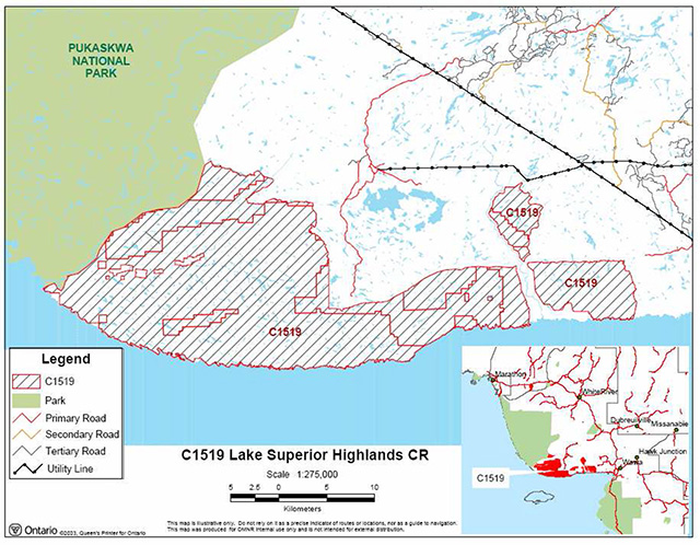
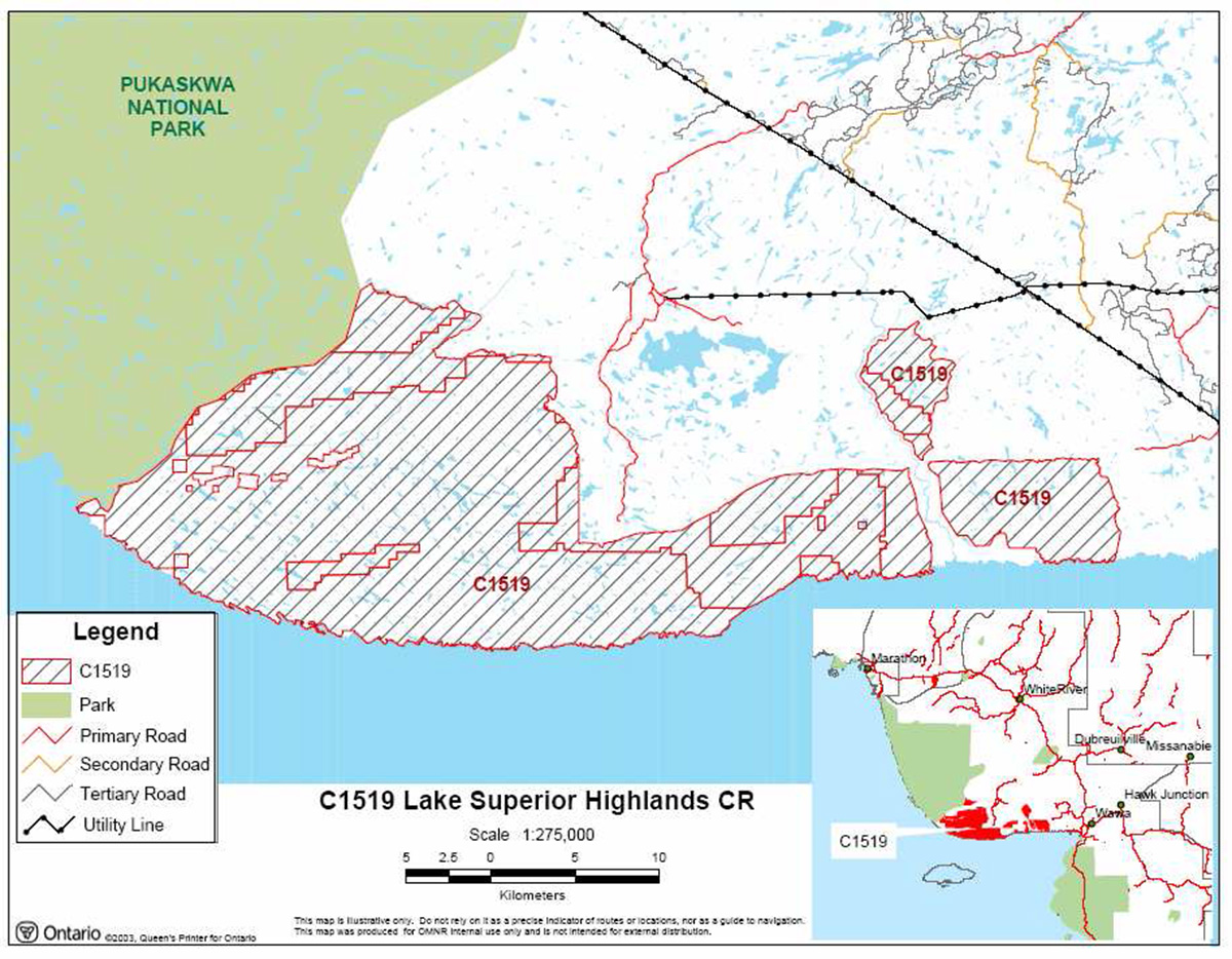
Lake Superior Highlands Conservation Reserve is located approximately 20 kilometers west of the town of Wawa and borders Pukaskwa National Park’s eastern boundary. The conservation reserve (CR) has an area of 62,122 hectares and is dominated by moderately broken bedrock with recent burns, mixed forests and sparse forest (Burkhardt 2004). The boundary was extended to follow a waterway down to Lake Superior’s shoreline as this creek was part of the natural drainage way, to facilitate gene flow to the shoreline and to maintain the connection of the upland to Lake Superior. The area also provides critical habitat for the woodland caribou. The CR is within the Wawa Forest Management Unit in the Wawa District.
The public was invited to comment on the proposed boundary of Lake Superior Highlands CR in August/September of 2000. The public will be invited to comment and review on the draft SCI in early 2005. Comments and concerns registered will be reflected in the final Statement of Conservation Interest. A final inspection opportunity will be provided for the public to review the approved SCI document. This document was prepared by an interdisciplinary planning team having expertise in forest ecology, biology, land management, and fire management. A draft was provided to the MNR Regional Planning Unit for review.
This basic SCI provides guidance for the management of the Lake Superior Highlands Conservation Reserve and provides the basis for the ongoing monitoring of activities. More detailed direction is not anticipated at this time. Should significant facility development be considered or complex issues arise requiring additional studies, more defined management direction, or special protection measures, a more detailed Resource Management Plan will be prepared with full public consultation.
Submitted by:
Paul Gamble
Plan Author
Date: February 22, 2006
Originally signed by:
Terry Taylor
District Manager
Date: February 23, 2006
Approved and originally signed by:
Rob Galloway
Regional Director
Northeast Region
Date: March 15, 2006
1.0 Introduction
Lake Superior Highlands Conservation Reserve is located within Wawa District of the Ministry of Natural Resources Northeast Administrative Region. It is a 62,122 hectare site that is currently being regulated as a Conservation Reserve (CR). Located within the Wawa Forest Management Planning Unit, it is approximately 20 kilometers west of the town of Wawa. The site was recommended for Conservation Reserve status in the Ontario’s Living Legacy Land Use Strategy, approved in July 1999.
Direction for establishing, planning and managing conservation reserves is defined under the Public Lands Act and the Crown Land Use Policy Atlas. Statements of Conservation Interest are prepared under the authority of Procedural Guideline A – Resource Management Planning. (Policy 3.03.05, OMNR 1997). “Ontario’s network of natural heritage areas has been established to protect and conserve areas representative of the diversity of the natural regions of the province, including species, habitats, features and ecological systems which comprise that natural diversity.”
In late 1999, consultation on boundary refinement was conducted with the current SFL holder Clergue Forest Management, local First Nations and the general public. Since public consultation regarding boundary refinement of the site generated little interest at the time and higher level planning documents provide direction on most activities in the reserve, a more detailed Resource Management Plan is not required.
The purpose of this Statement of Conservation Interest (SCI) is to identify and describe the values of the proposed Lake Superior Highlands Conservation Reserve. The SCI also outlines the activities that occur within the proposed reserve and provides guidelines for the management of current and future activities in the context of protecting the natural and cultural values.
Conservation reserves complement provincial parks in protecting representative natural areas and special features. Most recreational activities (e.g. hiking, nature appreciation, sport hunting and fishing) are permitted, provided they do not impact the natural features being protected. Mining, hydroelectric power development and commercial forestry are prohibited by legislation and the approved Ontario’s Living Legacy Land Use Strategy (OMNR 1999) guides many other activities. The Lake Superior Highlands CR helps to contribute to the representation of the province’s ecosystems and natural features.
2.0 Goals and objectives
2.1 Goal of statements of conservation interest
The goal of conservation reserves is to protect natural heritage and cultural values on public lands while permitting compatible land use activities.
2.2 Objectives of statement of conservation interest
2.2.1 Short term objectives
The short-term objectives are:
- To identify the state of the resource with respect to natural heritage values and current land use activities for the conservation reserve.
- To manage the conservation reserve to protect the integrity of its natural values via specific guidelines, strategies and prescriptions detailed in this plan.
2.2.2 Long term objectives
The long-term objectives are:
- To establish representation targets and validate the site as a potential scientific benchmark.
- To identify research/client services, and marketing strategies.
- To give direction to evaluate future new uses or economic ventures.
- To provide direction to evaluate new uses or economic ventures through the application of a Test of Compatibility (Procedural Guideline B – Land Uses PL 3.03.05 (Appendix 8.2).
- To create a public awareness of the values within the conservation reserve and promote responsible stewardship of the protected area through partnerships with local stakeholders.
- To identify scientific values on the site in relation to provincial benchmarks and identify the necessary monitoring and/or research to maintain the integrity of those values.
3.0 Management planning
3.1 Planning area
Conservation reserves are established by regulation under the Public Lands Act. Lake Superior Highlands Conservation Reserve is expected to be regulated as a conservation reserve in 2005. Upon regulation, Ontario Regulation 805/94 will apply. The planning area for this SCI is the proposed regulated boundary of the conservation reserve (Appendix 8.1 Site Map).
For purposes of Resource Management Planning and for other land uses, particularly for Forest Management Planning, the boundary of the conservation reserve in itself will not be treated as a ‘value’. Management Prescriptions presented in this plan will relate to the activities within the conservation reserve, will identify the location, shape, size, significance and sensitivity of natural heritage values, and will identify additional special features within the boundary of the site. Management actions outside the boundary of the conservation reserve will continue to consider the site’s natural heritage features, recreational values and protection requirements within larger landscape plans such as Forest Management Plans.
3.2 Management planning context
The Lake Superior Highlands Conservation Reserve and its associated permitted uses will receive its direction from the Ontario’s Living Legacy Land Use Strategy (OMNR 1999) and the Crown Land Use Policy Atlas. Subsequent planning will also follow the direction developed in this plan. By regulation, this reserve cannot be used for mining, commercial forest harvest, hydroelectric power development, peat/aggregate extraction or any other industrial use. The conservation reserve has been withdrawn from the Wawa Forest Sustainable Forestry License (SFL) and commercial forestry will no longer occur within its regulated boundaries. Since there has been no recent timber harvesting, post-harvest silvicultural activities will not be required as a non-conforming use.
Existing activities, such as sport fishing and hunting and existing bear management will continue to be permitted. The SCI and future management will attempt to resolve conflicts regarding incompatibility between uses and to ensure that identified values are adequately protected.
At present, there is no land in the CR under land tenure. In the future, land in the conservation reserve will not be sold or leased. New uses and potential commercial activities may be acceptable if they do not impact the natural heritage values of the site. Such activities will be considered on a case-by-case basis and reviewed using the Procedural Guideline B – Land Uses – Test of Compatibility PL 3.03.05 (OMNR 1997). Authorization for potential compatible uses will be in the form of a Land Use Permit or a License of Occupation.
Fish and wildlife management activities will generally occur in a manner similar to surrounding crown lands.
Fire Management is described in Section 6.3.
Specific land and resource use is described in Section 5.
3.3 Planning process
The level of management planning required to fulfill the protection targets is determined by the complexity of issues that need to be addressed. Guidelines for the preparation of this document are outlined in Procedural Guideline A for SCI and RMP PL 3.03.05 (OMNR 1997). The level of planning determined for this SCI was a Basic SCI as there were no known issues at the time of consultation for the boundary refinement. This basic SCI will only address known issues or current proposals with respect to permitted uses or potential economic opportunities brought forward during the planning process. Future proposals for development or land use will be reviewed through a Test of Compatibility.
This SCI was distributed to staff in the Wawa District OMNR office for their review and comments.
This SCI will be reviewed by the Wawa District Manager and upon approval will be presented to the Northeast Regional Director.
The planning process for the Lake Superior Highlands Conservation Reserve involves three public consultation phases. In January 2002, notices appeared in the Wawa, Manitouwadge and Marathon newspapers advising that planning for the CR was being initiated and inviting the public and interested organizations to supply background information and viewpoints. There was also a direct mail out to the public and to organizations known to be interested in or affected by the conservation reserve at the time.
The draft SCI will be available for public viewing and we will be incorporating any comments into the SCI that are necessary. In addition; newspaper notices have invited anyone interested to request a copy of the draft SCI.
The final public consultation phase will be an inspection of the MNR-approved SCI. The approved SCI will be available for public viewing at the District office. Following this consultation, the plan will be implemented.
Notices will not be placed on the Environmental Registry because this SCI is not considered a policy under the Environmental Bill of Rights.
4.0 Background information
4.1 Location and site description
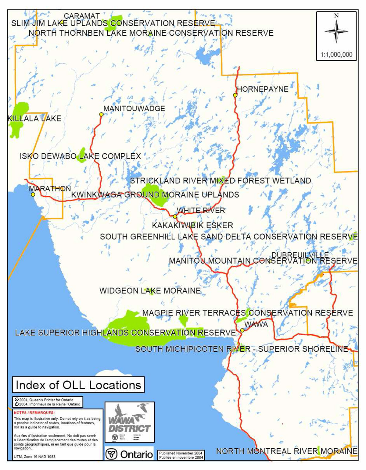
The Lake Superior Highlands Conservation Reserve is located adjoining Pukaskwa National Park’s eastern boundary. The closest access point is past the Eagle Gold Mines down the Paint Lake Road via Highway 17 west of Wawa. It is also approximately 50 kilometers northwest of the town of Wawa. Additional location and administrative information can be found in Table 1 as well as in Appendix 8.1 – 8.2 Location and Site Maps.
4.1.1 Physical description
Lake Superior Highlands Conservation Reserve is a 62, 122 hectare parcel of Crown land with its configuration comprised of vectored boundaries that dominate the northern boundaries of the site, Pukaskwa River to the western edge of the site, Lake Superior to the southern boundary and the Makwa River for the eastern boundary.
The site is located in the Tip Top Mountain ecodistrict (3E-4) of the Lake Abitibi ecoregion (3E). The Lake Abitibi Ecoregion is found to contain moderately to gently rolling bedrock, generally covered by deep deposits of clay, silt and sand (Hills 1959). The Tip Top Mountain ecodistrict is characterized by strongly to moderately broken upland of granite rock covered by a shallow layer of granitic sand and silty sand. Regional vegetation consists of stands of spruce, fir, poplar and birch on fresh sites on moderately sloping terrain. White and red pines are found on sand ridges and white cedar can be found in sheltered valleys. The forest climate type is mid-humid, mid-boreal (Hills 1959).
Table 1: Location and administrative details for Lake Superior Highlands Conservation Reserve
Table 1 reformatted into a list
- Territorial District: Algoma/Thunder Bay
- MNR Region / District: Northeast / Wawa
- Township: Homer, Groseilleirs, St. Germain, Franchere, Warpula and Unsurveyed
- Ecoregion – Ecodistrict: (Hills 1959) 3E-4
- Park Zone: Northeast
- Regulation Date: TBA
- Total Area: 62,122 hectares (of which 7 775.5 ha is in forest reserve)
- Ownership: Crown
- UTM Coordinates: 163532 (Zone 16)
- NTS Map Numbers: 42 C/3 (Mishibishu Lake) & 42 C/4 (Pukaskwa River), 41 N/13 Bonner Head and 41 N/14 Dog Harbour
- OBM Map Numbers: 6580053200 6590053200 6600053200 6610053200
6620053200 6630053200 6580053000 6590053100
66000531000 6610053100 6620053100 6630053100
6640053100 590053000 6600053000 6610053000
6620053000 - Wildlife Management Unit: WMU 33: Forest Management Unit: Wawa
4.2 History of the site
The conservation reserve is within the Michipicoten First Nation, the Ojibways of the Pic River and the Pic Mobert First Nation traditional land use area. The site is in the area covered by the Union of Ontario Indians (UOI) and the Robinson-Superior 1850 Treaty area. There are currently only native values collected and identified by Michipicoten First Nation. Most values are berry picking, traditional campsites, picnic areas and hunting fishing areas found along the coast of Lake Superior.
There are also some values identified by a First Nation trapper inland such as trails, portage routes, trapping routes, hunting areas and fishing lakes.
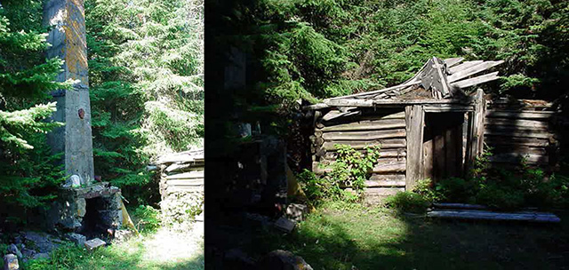
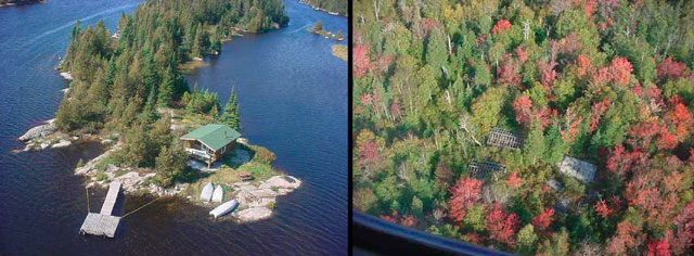
There are several abandoned mining exploration camps in the site (see Figure 3).
4.3 Inventories
Table 2 illustrates the inventories/surveys completed for Lake Superior Highlands CR, as well as any future requirements for earth and life sciences, cultural, recreational or other categories. The detailed Earth (Kor 2004) and Life Science Checksheets (Burkhardt 2004), and section 4.1 and section 5.0 describe the key features of the CR.
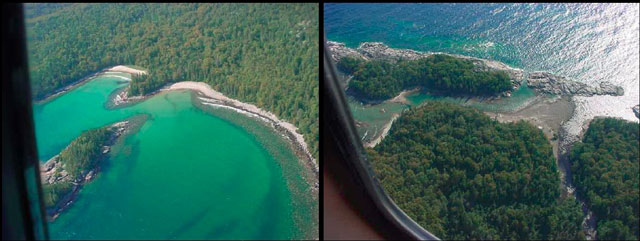
Table 2: Inventory and Survey Information for Widgeon Lake Moraine Conservation Reserve
| Survey Level | Earth Science | Life Science | Cultural | Recreational |
|---|---|---|---|---|
| Reconnaissance | Kor, P.S.G.., 2004, Lake Superior Highlands (C1519), Planning Summary of Bedrock Geology and Surficial Features | Burkhardt, B. Dec.21, 2004, Lake Superior Highlands Conservation Reserve (C1519) Life Science Checksheet. | Michipicoten Native Values Maps 2004 | Gamble, P., 2004, Lake Superior Highlands Conservation Reserve (C1519) Recreation Resource Inventory Report. |
| Detailed | None | None | None | None |
| Requirement | Recommend further review | Recommend further review | Recommend monitoring | Recommend monitoring |
5.0 State of the resource
This section will identify the state of the resource within, bordering or crossing the boundary of the site. The state of the resource will include the natural heritage values present within the site and those values that are adjacent to but within the CR boundary or that may cross the conservation reserve’s boundary within the general use area where an artificial vectored boundary exists. Current land use activities including tenure and past and current development within the planning area will also be discussed.
5.0.3 Features represented in this conservation reserve
The Lake Superior Highlands Conservation Reserve was recognized by the Ontario Living Legacy Strategy as regionally, if not provincially significant, earth science site based on air photo interpretation by Phil Kor and flight inventory observations by Kristjansson (2004). Located within Section B.9 (Superior) of Rowe’s Forest Regions of Canada, the site is characterized by variable forest, ranging from mixed types with luxuriant shrub undergrowth to floristically poor, single-dominant conifer types (Burkhardt, 2004). The site is dominated by white birch mixedwood, white birch hardwood mixed and white birch predominant hardwood stands. Old growth stands were scattered throughout the reserve, but not as prevalent as the stands in the 59 – 89 age range.
Wetlands only account for 2.54% of the reserve according to the FRI examined, but there are a lot more present such as meadow marsh and shore fens, open water marshes in the shallow lakes, and thicket swamps and the occasional conifer swamp (Burkhardt 2004).
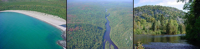
There are several major river systems within the site such as the Julia River, the Floating Heart, the Eagle, the Pipe and Little Pipe, and the East Pukuskwa which defines the western boundary, and the Makwa which defines the eastern boundary. Several of the rivers contain rapids and waterfalls that are visible from the air by helicopter or plane.
The western boundary of the reserve running roughly north south draining into Lake Superior is the East Pukuskwa River (see Figure 3). This river is a designated canoe route that contains numerous portages around waterfalls and deep gorges. There are several designated campsites along the way that are actually within Pukaskwa National Park. This river serves as a connection between two protected areas that can be shared by both the users of the conservation reserve and the National Park. Another connection to an adjacent land use area within the conservation reserve is the Nimoosh Provincial Park which encompasses the boundaries of the both the Dog River and the Jimmy Kash River. The Dog River is also a known designated canoe route more popularly known from Bill Mason’s travels. At the mouth of the Dog River there are Native pictographs that can be viewed from watercraft. Although there are other rivers within the conservation reserve that could be navigated by the experienced paddler, there is very little access points and no maintained portages (Gamble 2004).
The Lake Superior coastline consists of coves, bedrock, cobble/pebble or sand substrate, harbours or extreme rock faces with talus slopes (Burkhardt 2004). The most abundant surficial sediments in the CR consist of glaciolacustrine sands and silts (map unit 6), with distinct shoreline and nearshore features such as wave-cut bluffs and terraces, and bars and spits (map units 6f, 6e). These deposits occupy bedrock valleys and modern shoreline locations up to the highest levels of early postglacial lake levels in the Superior basin, and likely formed as deltaic valley fills (Kor 2004). The bedrock features within Lake Superior Highlands CR may be provincially significant, as there are very few examples of greenstone belts in the protected areas system to date. As such, the present boundaries of the CR enclose a fairly complete segment of a major greenstone belt, thereby encompassing its lithologies (variety of rock types), their associations, variations in metamorphic grades, and structural associations. A more detailed evaluation of the CR’s bedrock geology is required to determine the degree of representation and significance that occurs (Kor 2004).
5.0.2 Quality of features represented
The quality of the representation and the current characteristics of the natural features found within the conservation reserve are as important as the overall representative features that are being protected. A number of factors are considered in the evaluation of the site, including; diversity, ecological factors, condition, special features and current land use activities.
Condition
The disturbance around the site ’rated as low or the condition is good to excellent’ (Burkhardt 2004). There are several campsites, both designated and non-designated, along the coast of Lake Superior that are known of, but the impact from these sites is minimal. The only natural disturbance observed was some white birch decline in the east end and this was apparent outside the reserve as well (Burkhardt, 2004).
There are several abandoned mining exploration camps observed throughout the site (see Figure 4). Knowledge of the exact location and condition of these exploration camps is necessary to find out for safety.
Diversity
Diversity is a measure of the site’s life and earth science variability. It is based on the number and variety of natural landscape features and earth science values. According to the OLL Land Use Strategy (1999), the CR is very diverse. Based on the observations made by Barb Burkhardt in 2003, the Quarternary Geology and the NOEGTS (the Northern Ontario Engineering Geology Terrain Study); the site was given an initial rating of high. Since the majority of the communities account for less than 1%, it is suggested that the diversity rating be dropped to medium (Burkhardt 2004).
Several of the landform: vegetative communities are provincially significant as they contribute to the minimum amount required in the ecodistrict to be provincially significant (Burkhardt 2004). When examining Barb Burkhardt’s analysis of the site, she points out that there are many other features which contribute to the diversity of the CR. For instance, the rock faces that were not captured by the FRI (Forest Resource Inventory) exhibit communities that would not exist in any other forest habitat such as the artic alpine communities (see Special Features Section). As well, the diversity and different wetland types that are present in the site and the rivers and their varied structure and habitats.
Ecological factors
Ecological factors are significant to the quality of representation within the conservation reserve and include size, shape, sensitivity to potential disturbances, and current linkages to the larger landscape. The boundaries of Lake Superior Highland CR are composed of vectored, cultural and ecological boundaries. As suggested by Burkhardt in 2004, for protection of the coastline a marine area of protection should be added onto the southern boundary that follows the coastline. This would more accurately represent the true coast found in the reserve. In addition to the many small islands and shoals found there, there is one Heron rookery located on Crane Island near the western boundary on Lake Superior, several harbours and coves that have historical features such as shipwrecks.
The CR forms an important and critical natural landscape link with Lake Superior Provincial Park, Michipicoten Island Provincial Park, Michipicoten Post Provincial Park, Pukaskwa National Park, Nimoosh Provincial Park and several provincial conservation reserves. It creates a near continuous block of protected areas for the entire northeast and east shore of Lake Superior down to Montreal River. The potential is present to connect to the northwest up the eastern shore of Lake Nipigon north through Wabakimi Provincial Park in the OMNR Northwest Region and from there to the Hudson Bay Lowlands. This connection is important for the continued existence of many animal and plant species such as the woodland caribou and some rare arctic-alpine disjunct plants (Wade 2001) (Burkhardt 2004).
The site serves several hydrological functions. The many streams and rivers convey water very quickly to Lake Superior following spring thaw and inclement weather as insufficient wetlands are present to attenuate higher water levels. This was observed during the aerial reconnaissance survey following a major rainstorm. Erosion from wave action or higher water levels is reduced since the shorelines are vegetated. The site also contains many headwaters with the assumption that the water source is from the many slopes (Burkhardt 2004).
Special features
The area is important for some species identified on Ontario’s Species at Risk list (OMNR (1) 2004). Peregrine Falcons, listed as an endangered species, have been observed nesting (and monitored by the Wawa OMNR office) in three locations.
The Woodland caribou, rated as threatened, have been observed in the site. The Wawa Forest has been considered an important haven for caribou living along the coastal strip, from Pukaskwa National Park (PNP) to the Lake Superior Provincial Park to 5 km inland as this area has very little impact from human intrusion (Neale 2000). Presently caribou mainly occur on islands and in areas with rugged terrain which provide escape from predators. In C1519, caribou have been documented as far east as Mountain Ash Hill in the 1970’s and the Eagle River Area in the 1980’s. Most sightings west of Wawa are now confined to Pukaskwa National Park to the west of the conservation reserve (Wade 2001: Eason 2005: Burkhardt 2004).
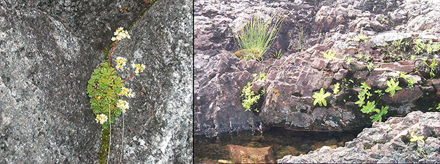
The Lake Superior coastline within the conservation reserve has long been known to support assemblages of arctic and alpine plant species, known as arctic-alpine disjuncts (see Figure 2 above). The convoluted shoreline has a wide range of microhabitats, moisture regime and temperature conditions.
They are present on base-rich rocks such as basalt and diabase and gaps in distribution occurs on acidic igneous rocks. Several of these species include encrusted saxifrage (Saxifraga paniculata), knotted pearlwort (Sagina nodosa), Bird’s-eye primrose (Primula mistassinica) and a butterwort (Pinguicula vulgaris). Many sources have listed the butterwort as rare (Soper & Maycock 1962; NHIC 1998; White 2000) (see Appendix 2 in the Life Science Checksheet for Arctic-Alpine Checklist, (Burkhardt 2004)).
Finally, as recorded in the Life Science Checksheet by Burkhardt in 2004, the bedrock lineaments which create cooler-than-normal habitat at the base of the slopes. On the upper slopes, the appearance of maple trees occur in the warmer-than-normal habitats.
Current land use activities
Current land use activities are limited to trapping, fishing and hunting (Gamble, 2004). The area is difficult to access due to no road access from the Wawa Forest Management Unit. The closest access is from the Eagle River Gold Mine roads located north of the site near Mishibishu Lake. The close proximity of Pukaskwa National Park will contribute to the use of the site being very low for the average person. There will likely see an increase in recreational activities along the coast for camping, boating, fishing and sailing. There is no foreseeable potential large impacts that may occur from recreation activities increasing. With 13% of the total area held in Forest Reserve status, there is possibility that mining activities including explorations and digs could occur within the perceived boundaries of the site.
5.1 Social/economic interest in the area
Linkage to local communities
This conservation reserve contributes to the local community by providing an ecosystem that supports the production of wildlife. Local trappers, hunters and fishermen who harvest within the site indirectly benefit the local community economy.
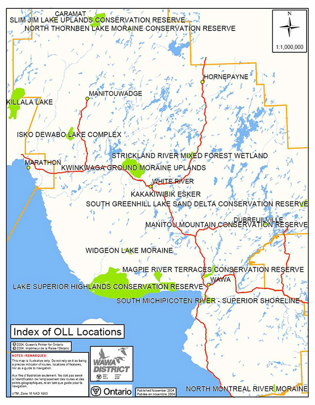
Lake Superior Highlands Conservation Reserve is located in close proximity to Pukaskwa National Park and Pukaskwa River Provincial Park, Nimoosh Provincial Park, as well as Widgeon Lake Moraine Conservation Reserve. Future opportunities to link the recreational value of these areas may also contribute to the local communities of Wawa, White River, and Marathon. The linkages will also support the production and sustainability of wildlife throughout the landscape.
Heritage estate contributions
Lake Superior Highlands CR contributes to the province’s parks and protected areas by preserving a number of natural heritage values mentioned in the previous section (5.0). The lack of industrial disturbance and current land use in the CR will help to ensure that fragile vegetation communities, significant geological features and waters are protected into the future. Furthermore, the site’s distinctiveness as a record of glacial recession may distinguish this site as an important scientific benchmark in the years to come. Future managers will have to balance the need to maintain the quality of the current representation and the needs of present and future users.
Aboriginal groups
The conservation reserve is within the Michipicoten First Nation’s traditional land use area. There are several traplines that are currently registered to Michipicoten First Nation members and access to these areas is either done by foot or snowmobile on unmaintained trails. Traditional Values Mapping exercises are taking place currently and if more values are identified within or adjacent to the site, they will be properly mapped and documented to avoid disturbance and maintain discretion and protection.
Mining industry and Ministry of Northern Development and Mines
There are several active mining claims that fall within the borders of the site, all of which are contained in the Forest Reserve portions. Currently, discussions are taking place between Ontario Prospector Association (OPA) and Partnership for Public Lands (PPL) concerning the disentanglement issues for the Forest Reserve portions. Mineral potential is considered to be very high.
5.2 Natural heritage stewardship (vegetative/plant community management and earth science value protection)
There is no present monitoring or research program being conducted in conjunction with this conservation reserve by the Ministry of Natural Resources. There are however several other studies that have and will continue to be completed within the conservation reserve. A research team headed by a Botanist from Guelph University has conducted Plot inventories on areas along the coast to study the rare arctic-alpine disjuncts species that are found there. Research papers are currently being written regarding these species. A species list is available as an appendix in the Life Science Checksheet, Burkhardt, 2004. As mentioned, there are Peregrine Falcons found along the coast and up the East Pukuskwa River. These sites along with any additional sites will continue to be monitored by volunteers.
Campsites that are designated or non-designated will continue to be monitored for quality and condition by the users, and additional areas for refuge from Lake Superior will be studied by the organizations that are currently using the site. If and when there appears to be impacts from high recreational use, a management strategy to handle the capacity may have to be amended into the plans.
Current fire management is concurrent with that practiced on adjacent crown land. Management strategies are described in section 6.2 State of the Resource Management Strategies.
5.3 Fisheries and wildlife
Lake Superior Highlands Conservation Reserve is home to large wildlife species such as black bear and moose. The conservation reserve is also inhabited by a number of small game species such as snowshoe hare, lynx, bobcat, beaver, and otter. Inventories have not been conducted to verify the other wildlife species that may utilize this site.
There have been no identified lake surveys in which water quality data was collected within the conservation reserve. However the Pipe river is identified as a Walleye spawning river from the OMNR Wawa NRVIS database.
As mentioned before, the Woodland caribou, rated as threatened, have been observed in the site. The Wawa Forest has been considered an important haven for caribou living along the coastal strip, from Pukaskwa National Park (PNP) to the Lake Superior Provincial Park to 5 km inland as this area has very little impact from human intrusion (Neale 2000). Presently caribou mainly occur on islands and in areas with rugged terrain which provide escape from predators. In C1519, caribou have been documented as far east as Mountain Ash Hill in the 1970’s and the Eagle River Area in the 1980’s. Most sightings west of Wawa are now confined to Pukaskwa National Park to the west of the conservation reserve (Wade 2001: Eason 2005: Burkhardt, 2004).
5.4 Cultural heritage stewardship
There are no known archaeological or cultural heritage values in the conservation reserve. Given the lack of evidence of prehistoric use, and the curtailment of industrial activities, an archaeological survey is not necessary at this time.
There are however sites where there is evidence of human disturbance and occupation within and bordering the site. For example, there is one known abandoned trapper’s cabin that is located outside of the boundary but along the coast of Lake Superior (see Figure 4 below).
There is an archaeological site located just west of the site in Pukaskwa National Park. An old settlement known as Pukuskwa Depot was located at the mouth of the Imogene River at Imogene Cove. The settlement was home to 300-400 residents who were involved in forestry, logging, fishing, hunting and trapping lifestyles.
5.5 Land use/current or past development
As described in previous sections, past land use has been low. There are evidence of mining exploration camps throughout the site, such as northwest of Mountain Ash Hill, the north end of Floating Heart River and north of the east Pukuskwa River. Associated with these camps were blazed trails (gridlines). Most of the trails are visible on 1:20000 scale aerial photos as the vegetation was removed from the bedrock (Burkhardt 2004). The conservation reserve rests on Crown Land.
There are numerous mining claims held within the Forest Reserve sections of the site. As recommended by Burkhardt in 2004, a corridor should remain intact and devoid of any mining activity during the OPA/PPL discussions to protect the values found along the coast and to provide a link with other protected areas adjacent to the reserve.
There are two known Land Use Plans (LUPs) within the conservation reserve. One is a remote tourist camp operated by Hawk Air located on Jackfish Lake. The other is located within Ganley Harbour Wilderness Area along the coast for a commercial fishing operation to dock. The other human disturbance noticeable from air when flying along the boundary of the reserve and the adjacent Pukuskwa National Park is a cut 8 feet wide defining the boundary line between the park and conservation reserve.
5.6 Commercial use
There are portions of four Bear Management Areas (BMAs) within the CR; WA-33-012, WA-33-013 and WA-33-010. Three of these BMAs are active; however, the activity of the portions within the CR is not determined (returns are reported for the entire BMA). The last portion that is not active is a reserve area located mostly in the eastern part of the conservation reserve and includes Nimoosh Provincial Park.
There are six trapline areas within or bordering the reserve; WA-69, WA-68, WA-66, WA-70, WA-71 and WA-51. All are currently Native traplines. Michipicoten First Nation has a long traditional use activity within the area of the conservation reserve.
There are currently only 4 baitfish areas located in the eastern part of the conservation reserve; WA-107, WA-108, and WA-105. The other area that comprises the remainder of the site falls into an area that has no allocated Baitfish Zones.
5.7 Tourism/recreation use/opportunities
Tourism and/or recreational opportunities in this conservation reserve are currently very low due to its inaccessibility (see Appendix 8.1). There is however potential for this type of use to develop in the future. Some trails have been blazed in association with traplines that may potentially be used for hiking trails. Hiking trails and canoe routes could potentially be developed in the future and camp sites could be cleared to allow for back country camping experiences. A Test of Compatibility (Appendix 8.3) must be passed before they are deemed acceptable. There are no current proposals submitted for recreational development since there is currently very limited access to the site.
There is great potential for more campsites to be developed along the coast for boaters, kayakers and sailboats. For more information on existing and potential campsites see Lake Superior Recreational Inventory Report completed by Joel Cooper in 1998.
5.8 Client services
No infrastructure or interpretive facilities are proposed for the site. Informal wildlife viewing and nature appreciation can continue without further development.
6.0 Management guidelines
6.1 Management planning strategies
The land use intent outlined in Ontario’s Living Legacy Land Use Strategy and the Crown Land Use Policy Atlas provides context and direction to land use, resource management, and operational planning activities on Crown Land. Commitments identified in the above strategy and current legislation (PL Procedure 3.03.05) will form the basis for land use within Lake Superior Highlands Conservation Reserve. For up-to-date information on permitted uses refer to the Crown Land Use Policy Atlas at Crown Land Use Policy Atlas. See Appendix 8.5 for a summary of permitted uses in Lake Superior Highlands Conservation Reserve.
Existing permitted uses within the conservation reserve may continue, unless they are shown to have a significant negative impact on the values within the site.
Proposed uses and development within the conservation reserve will be reviewed on a case-by-case basis. A Test of Compatibility (Appendix 8.2) must be passed before they are deemed acceptable. The emphasis will be on ensuring that the natural values of the conservation reserve are not negatively affected by current or future land use activities. Therefore, any application for new specific uses will be carefully studied and reviewed. The Ministry of Natural Resources (MNR), partner organizations and/or proponents may undertake such studies. Applicable environmental assessment requirements will also be met according to A Class Environmental Assessment for Provincial Parks and Conservation Reserves. Authorization for potential compatible uses will be in the form of a Land Use Permit or a License of Occupation.
6.2 State of the Resource Management Strategies
Natural Heritage Stewardship – Vegetative/plant community management and earth science value protection
This conservation reserve will be managed by allowing vegetative communities to develop naturally while existing traditional and recreational uses continue. Monitoring of sensitive wetland complexes may be necessary depending on the degree of recreational use.
The MNR recognizes fire as an essential process fundamental to the ecological integrity of conservation reserves. In accordance with the existing Conservation Reserve Policy and the Forest Fire Management Strategy for Ontario, forest fire protection will be carried out as on surrounding lands.
Whenever feasible, the MNR fire program will endeavor to use “light on the land” techniques, which do not unduly disturb the landscape, in this conservation reserve. Examples of light on the land techniques may include limiting the use of heavy equipment or limiting the number of trees felled during fire response efforts.
Opportunities for prescribed burning to achieve ecological or resource management objectives may be considered. These management objectives will be developed with public consultation prior to any prescribed burning, and reflected in the document that provides management direction for this conservation reserve. Plans for any prescribed burning will be developed in accordance with the MNR Prescribed Burn Planning Manual, and the Class Environmental Assessment for Provincial Parks and Conservation Reserves.
Personal use permits for wood harvesting are not permitted. Salvage of standing, fallen, or sunken dead trees will not be permitted, except when authorized in conjunction with approved maintenance activities.
The collection/removal of vegetation and parts thereof (including Taxus Canadensis) will not be permitted. However, subject to a Test of Compatibility (Appendix 8.2), the Area Supervisor may authorize the collection of plants and/or parts for the purposes of research or scientific study.
Forest renewal by artificial means will not be appropriate for a natural area. Similarly control of native pests will not be permitted. Programs may be developed to control invasive non-native forest insects and diseases in the conservation reserve where these threaten significant values in or adjacent to the site. Where insects or disease threaten significant values, in or adjacent to the site, control will be directed as narrowly as possible to the specific insect or disease. Biological control will be used whenever possible. If this circumstance should arise the control method would undergo a Test of Compatibility (Appendix 8.2).
All earth and life science features will be protected by defining compatible uses, enforcement direction through applicable legislation, and monitoring and mitigating issues. Industrial activities such as; timber harvesting, prospecting, mining, and new hydro generation will not be permitted within the boundaries of the conservation reserve. Energy transmission, communication and transportation corridors or resource roads or construction of facilities are discouraged, through existing planning process. Exceptions based on a Test of Compatibility (Appendix 8.2) may be made for minor structures.
Ontario Ministry of Natural Resources will provide leadership and direction for maintaining the integrity of this site as a natural heritage estate. Research, protection education and understanding and interpretation of the natural heritage features of the site will be encouraged and fostered through local and regional natural heritage programs and initiatives.
Fisheries and wildlife
Fish and wildlife resources will continue to be managed in accordance with policies and regulations prevailing in the area and under the direction of the Wawa/White River Area Supervisor. Provincial legislation and policy will dictate management and enforcement objectives for this area.
Existing hunting and sport fishing will be permitted by outfitters and the general public. No new commercial outfitting, outpost, hunting camps or new trap cabins will be permitted within the boundaries of the conservation reserve. The introduction of exotic and/or invasive species will not be permitted.
Cultural Heritage
Should the MNR consider new structural development, significant clearing of vegetation or altering of land within this conservation reserve, the MNR will adhere to the cultural heritage resource screening process as is identified in its Memorandum of Understanding (MOU) with the Ministry of Culture (MCL). While the purpose of this MOU is to provide a process to identify and protect cultural heritage resources when the MNR is reviewing work permits or disposing of Crown rights under the authority of the Public Lands Act, the considerations and criteria would also enable the MNR to identify high potential cultural heritage areas for other purposes within conservation reserves. If the screening process indicates that the site of a proposed activity is within an area of high cultural heritage potential, the MNR will consult with the MCL to determine the appropriate cultural heritage assessment requirements and will undertake a preliminary archaeological assessment if appropriate.
All aboriginal and treaty rights will continue to be respected and are not affected by the establishment of this conservation reserve.
Any future proposals or decisions that have potential impact(s) on the individual or aboriginal or community values will involve additional consultation with the affected aboriginal groups.
Social/economic
Under the Ontario Living Legacy Land Use Strategy, mining and related access will be allowed in a forest reserve. For those activities that could negatively influence the natural heritage values within or adjacent to the CR, the district will work with the proponent to identify and mitigate potential mining or natural heritage concerns.
Mining will not occur in any portion of the regulated conservation reserve boundary.
Land Use/past and existing development
Conservation reserve regulations do not permit mining, commercial forest harvesting, hydroelectric power development, the extraction of aggregate and peat or other industrial uses (Public Lands Act, Ontario Regulation 805/94).
The sale of Crown Lands within the conservation reserve is not permitted.
New recreation camps will not be permitted however; existing recreation camps will be permitted to continue. Existing camps may be eligible for “enhanced” tenure, but are not eligible for purchase of land. There are two forms of enhanced tenure that may be considered:
- Upgrade in the nature or type of tenure (e.g. from Land Use Permit to a lease)
- An extension in the term of the tenure (e.g. from 1 year to 10 years)
Applications for enhanced tenure will be approved if determined acceptable using a screening criteria. A change in tenure does not convey a commitment to provide for, or agree to, a change in the type or the standard of existing access to the recreation camp.
Unauthorized occupations of lands within the conservation reserve will be handled in accordance with approved policy, and any required structural removal will be at the owner’s expense.
New roads for resource extraction and/or private use will not be permitted, nor will additions to existing roads or upgrading of existing private roads be permitted.
New trails are not encouraged, however they may be considered when compatible with other recreational uses and the maintenance of environmental integrity. Any new trail development must go through a Test of Compatibility (Appendix 8.2) to ensure the quality of the life and earth science representation and any additional values (e.g. aesthetics, landscape views, sensitive areas) are maintained.
Use of existing authorized All-Terrain Vehicles (ATV) and snowmobile trails will be permitted to continue as long as they do not impair the natural features and values for which the area is identified and there are no significant environmental impacts. Consideration for new ATV and snowmobile trails will occur on a case-by-case basis. Public consultation will be an important part of the process. Non-trail snowmobile and ATV use will be permitted only for the direct retrieval of game and/or bait.
The use of existing unauthorized trails will be monitored to ensure that conservation reserve values are not being adversely impacted. Depending on the results of the monitoring, some of the unauthorized trails may need to be redirected from sensitive areas or eliminated completely.
The district may sometime in the future consider developing a trails strategy to ensure the values within the conservation reserve are fully protected while maintaining current permitted uses to occur.
Facility infrastructure and development for recreation may be considered in the future if there is a demonstrated need for such facilities. A more detailed management plan would be required prior to construction.
Commercial Use
Existing non-industrial commercial uses such as trapping and baitfish harvesting will be permitted to continue. Renewals and transfers will also be permitted. These activities will continue to be monitored in order to ensure they do not deplete natural resources and that they impose a minimal impact on the features identified for protection.
New non-industrial commercial activities (i.e. traplines) which overlap with the conservation reserve may be considered subject to a Test of Compatibility, consistent with provincial direction. Any new trails associated with the new non-industrial commercial activities must also be considered subject to a Test of Compatibility.
Existing commercial bear hunting operations are permitted to continue but the introduction of new operations will not be allowed. Lapsed BMA’s will not be reactivated, and transfer requests will be dealt with on a case-by-case basis.
Commercial wild rice harvesting will not be permitted. Other commercial food collection will also be prohibited; particularly mechanical blueberry harvesting methods that can damage plants and deplete the crop available for recreational pickers. The harvesting of Canada Yew will not be permitted within the conservation reserve.
Tourism/recreation
Tourism proposals will be assessed on a case-by-case basis and approved if compatible with natural values and other uses that may exist at the time.
Blueberry picking and other food gathering will continue to be permitted on a recreational basis.
Client services
The focus will remain on low key information and self-interpretation of conservation reserve features. Messages should focus on the area’s natural heritage features, recreation opportunities, nature appreciation and education.
At the present time there are no plans for structural development within this conservation reserve.
6.3 Specific feature/area/zone management strategies
The Lake Superior Highlands CR has not been delineated into zones for management of a specific resource. The site’s primary value is the coast as described by Gamble (Recreational Resource Inventory Report, 2004) and Burkhardt (Life Science Checksheet 2004).
Research in the CR will be encouraged, and some research activities could conceivably require special conditions such as elimination of noise or restrictions on harvesting of wildlife. Zoning of the CR for management of special features will require an amendment to this SCI.
The corridor that exists along the coastline linking protected areas such as Lake Superior Provincial Park and Pukuskwa National Park should remain during the OPA/PPL discussions as it provides a link with other protected areas and provides protection for special features. A marine environment should also be added to the site to include the islands and protect historical values.
6.4 Monitoring, assessment and research
Ongoing evaluations and reports will have to rely on current and new technologies such as satellite imagery, global positioning systems (GPS), supplementary aerial photography (SAP) and/or aerial/ground reconnaissance surveys/assessments conducted periodically and placed within a GIS database. Such tools could help managers spatially record areas affected, severity of perturbations or management action as well as consider the sensitivity of values, the design of CR and determine the future desired condition of the site. Monitoring efficiencies could be enhanced via partnerships and internal coordination within MNR (Burkhardt 2004)
Consideration will be given to inventory and documentation of natural and cultural values, and the assessment of use/activity impacts. All research will be carried out in a non-destructive manner. Research proposals must follow Procedural Guideline C – Research Activities in Conservation Reserves (PL 3.03.05).
Research, education and interpretation will be encouraged to provide a better understanding of the management and protection of the natural heritage values and will be fostered through local and regional natural heritage programs, initiatives and partnerships.
6.5 Implementation and plan review strategies
Management of the CR will be done largely using a “hands-off” approach. For the short term, the forest community will develop without intervention, and low impact activities described in the plan will continue. Emphasis will be placed on awareness information highlighting conservation reserve values and appropriate uses.
Priorities will include:
- Maintaining the quality of life science representation features, such as the wetland complex surrounding the site and the tributaries of the Dog River, Jimmy Kash, Makwa, East Pukuskwa River and other major watersheds, while providing for the needs of recreation and other users
- Monitoring impacts of existing recreation use on the conservation reserve to ensure adherence to the management guideline and mitigating any negative effects
- Working with adjacent SFL holders and stakeholders to protect important values (e.g. old growth forest) that are cut as a result of the vectored boundaries
Lake Superior Highlands Conservation Reserve SCI will be reviewed on an ongoing basis as there is no formal review or expiry date for the document. This SCI will be amended through a standard process of minor and major amendments. Minor amendments will be processed in a relatively informal manner and will require the approval of the Wawa/White River Area Supervisor. These amendments will deal with uses and activities that do not affect any of the policies in this SCI (e.g. new uses and/or activities that are consistent with existing permitted uses).
Uses and/or activities that were not anticipated in the approved SCI and which may have an impact on the values of the conservation reserve will require a major amendment. In assessing major changes, the need for a more detailed Resource Management Plan will first be considered. This will include an opportunity for public comment and input and will require the approval of the Wawa District Manager and the Regional Director.
This SCI or future RMP, if required, plus the Crown Land Use Atlas and associated Crown Land Use Policy Atlas website will be amended to reflect any changes in management direction.
6.6 Marketing strategies
The site will be more generally promoted as part of the Parks and Protected Areas initiative, and at the current time information on the Lake Superior Highlands CR is available worldwide on the Crown Land Use Policy Atlas website.
Nearby Pukaskwa River Provincial Park, Nimoosh Provincial Park, Lake Superior Provincial Park and Pukaskwa National Park may be useful tools for making park users aware of the conservation reserve.
Any future economic or development proposals should go through a Test of Compatibility to ensure the natural heritage features are well protected. For example, any future trail development must consider the values found within the boundaries of the site, the rationale for developing trails within the site and the availability of current access through the site and surrounding areas. Furthermore, any new trail development will require a ‘Test of Compatibility’. Sensitive areas should be avoided.
Marketing activities will be kept to a minimum and there are no plans to actively promote the area for research or commercial purposes such as tourism at this time.
7.0 References
Bostock, H.S. 1970. Geology and economic minerals of Canada – Part A.
Burkhardt, B. December 21, 2004. Lake Superior Highlands Conservation Reserve (C1519) Life Science Checksheet – Step 2
Cooper, J. 1998. Lake Superior Highlands Conservation Reserve - Campsite Inventory Crins, W.J. 2000. Ecoregions of Ontario: Modifications to Angus Hills’Site Regions and Site Districts Revisions and Rationale. /page/crown-land-use-policy-atlas
Dersch, Carol. 2004. Lake Superior Provincial Park natural heritage specialist. Personal Conversation.
Eason, Gord. 2005. Area Biologist for Wawa OMNR District. Personal Conversation.
Gamble, P. 2003. Aerial Reconnaissance Notes.
Hills, G.A. 1959. A Ready Reference to the Description of the Land of Ontario and its Productivity. Ontario Ministry of Natural Resources.
Kor, P.S.G. 2004. Lake Superior Highlands C1519, Planning Summary of Bedrock Geology and Surficial Features.
Kor, Phil, 2004. Senior Conservation geologist, Main Office. Personal Communication.
Kristjansson, Rik 2004. Personal Communication.
Mulrooney, D. 2002. Ontario’s Living Legacy Guidelines for Recreation Resource Inventory, Version 3. Ontario Ministry of Natural Resources, Ontario Parks Planning and Research Section. pp. 30.
Neale, Graham K. 2000. Affects of snow depths on seasonal movements and homerange distributions of wolves, moose and woodland caribou in and around Pukaskwa National Park, Ontario, Canada. Thesis paper.
Ontario Ministry of Natural Resources (OMNR). 1974. Watershed Divisions Algoma, Sudbury and Timiskaming.
Ontario Ministry of Natural Resources. 1999. Ontario Living Legacy Land Use Strategy. Queen’s Printer for Ontario.
Ontario Ministry of Natural Resources. 2004. Crown Land Use Policy Atlas – Policy Report. C1519 Lake Superior Highlands. http://crownlanduseatlas.mnr.gov.on.ca/ Updated: June 30, 2004.
Ontario Ministry of Natural Resources (1). 2004. Species at Risk in Ontario List. Internal report.
Ritchie, G. and J.E. Thompson. 1998. Lands for Life Natural Heritage Reference Binder. Boreal East Planning Area.
Rowe, J.S. 1972. Forest Regions of Canada.
8.0 Appendices
8.1 Site map
8.2 Location Map
8.3 Procedural Guideline B – Land Uses – Test of Compatibility (PL Procedure 3.03.05)
The Conservation Reserve policy provides broad direction with regard to the permitted uses. The policy provides only an indication of the variety of uses that will be considered acceptable in conservation reserves. The only caution is that “any new uses, and commercial activities associated with them, will be considered on a case by case basis, and, they must pass a test of compatibility to be acceptable.”
What does a ‘test of compatibility’ mean?
An examination of this must start from the premise of why an area is set aside – specifically, its representative natural heritage values. Criteria are then identified to guide compatibility considerations. These criteria apply to the long-term acceptability of both existing uses and new uses.
-
Conformity to SCI/RMP: SCI describe values for which an area has been set aside and the range of appropriate uses that will be permitted in the area. SCI may also speak to the acceptability of other ‘new’uses currently not occurring in the area.
The first ‘test’ is: “do proposed new land uses and/or commercial activities conform to the direction of the SCI/RMP for the conservation reserve? Would the new use(s) depart from the spirit of appropriate indicator land uses in the SCI/RMP??”"
- Impact Assessment: If the proposed use(s) pass test 1 it is important to determine their impact on the area before they are approved. This should include the following:
- Impact on natural heritage values: “will the new use(s) impact any natural values in the area? If so how and to what degree? Is it tolerable?”
- Impact on cultural values: “will the new use(s) impact an historical or archaeological values in the area?”
- Impact on research activities: “will the new use(s) affect research activities in the area?”
- Impact on current uses: “will the new use(s) have any negative impact on the array of current uses?”
- Impact on area administration: “will the new use(s) increase administrative costs and/or complexity?” (For example, the cost of area monitoring, security and enforcement).
- Impact on accommodating the use outside the conservation reserve: “Could the use(s) be accommodated as well or better outside the conservation reserve?”
- Impact on socio-economics of the area: “will the new use(s) affect the community(ies) surrounding the area in a positive or negative way?” (For example, will the new use make an area less remote thereby affecting a local tourism industry that is dependent on the area’s remoteness for its appeal?"
- Impact on area accessibility: “does the new use(s) give someone exclusive rights to the area or a portion of the area to the exclusion of other existing uses?”
8.4 Summary of permitted land and resource uses
| Use | Permitted - (New) | Permitted - (Existing) |
|---|---|---|
| Commercial timber harvest, commercial hydro development | No | No |
| Mineral exploration and mining | No | No |
| Bait fishing, commercial fur harvesting | Maybe | Yes |
| Sport hunting | Yes | Yes |
| Sport fishing | Yes | Yes |
| Seasonal recreation camps ("hunt camps") | No | Yes |
| Commercial bear hunting | No | Yes |
| Tourism Facilities (for resource based tourism) and recreational trails | Maybe | Yes |
| Land Disposition | Maybe | Maybe |
| Roads | Maybe | Yes |
| Energy Transmission and Communications Corridors | No | No |
| Commercial Food Harvesting | Maybe | Maybe |
| ATV and Snowmobile use on trails | Maybe | Yes |