Little Current River Provincial Park Management Statement
This document provides policy direction for the protection, development and management of Little Current River Provincial Park and its resources.
Regional director’s approval statement
This revised Interim Management Statement will provide interim direction for the management of the above Provincial Park until a comprehensive Park Management Plan is prepared.
This statement will provide the basis for the subsequent preparation of the Park Management Plan.
I am pleased to approve this Interim Management Statement.
M. S. Millar
A/Regional Director
North Central Region
Revised March 1991
Background information
- Date: 27.05.89
- Name: Little Current River
- Class: Waterway
- M.N.R. district: Geraldton
- M.N.R. region: North Central
- Total area (ha): 9,930
- Land:
- Water:
- Site region: 3W;2W;2E
- Site district: 1; 3; 1
- Date in regulation: May 27, 1989
Little Current River Provincial Park map
Targets
Life science representation
Site type/landscape unit
Undocumented
Species/communities
NA
Earth science representation
- Geological theme
- Timiskaming Interstadial
- Driftwood Stadial
- Others undocumented
- Feature
- Cochrane Advance clay till, fluted terrain shoreline features and lake clays of Barlow-Ojibway.
Cultural resource representation
- Theme
- Unknown (high potential for sites)
- Theme segment
- NA
Recreation opportunities
- Day use
- N/A
- Car camping
- N/A
- Wilderess/back country
- 7,000
Inventories
| level/type | reconnaissance/completion date | detailed completion date | required? |
|---|---|---|---|
| earth science | detailed Inventory | ||
| life science | detailed Inventory | ||
| cultural | detailed Inventory | ||
| recreational | detailed Inventory | ||
| other |
Little Current River Provincial Park Interim Management Statement
I Land tenure
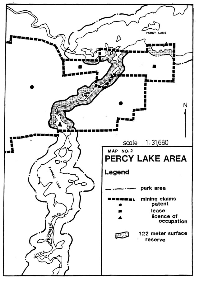
The Park boundary commences where the Little Current River flows eastward out of Superb Lake. The boundary is defined as an area 200 metres on either side of the waterway from the point of commencement to the eastern boundary of the Geraldton District. However, the area between Farrell Lake and Percy Lake does not constitute a portion of the park (see Map No. 2). This area is covered by leased and patented mining claims, and the land under water is covered by licence of occupation. Portions of 9 leased and 16 patented claims fall within this 200 metre area. All of these claims, except one, have the surface rights 122 metres from the waterway reserved to the Crown. The surface rights were reserved at the time the patents and leases were granted.
In addition, there are 4 land use permits that have been issued for outpost campsites along the Park waterway. Each site occupies about 0.4 hectares.
A portion of the Little Current River was designated as a Crown Reserve for the purpose of a wild river Park, in 1975 (see Appendix A).
Guideline:
The Crown will not acquire any of the patented or leased land within the Park area. However, the area will be withdrawn from staking within 200 metres of the waterway so that the land will revert to the Crown should the tenure lapse for any reason.
M.N.R. will meet with the company and/or individuals involved, to discuss opportunities for maintenance of scenic values through patented and leased areas.
Annual renewal of land use permits will occur until a Management Plan is completed.
II Land acquisition/disposition
N/A
III Existing/proposed development
Access may be gained to the Park by flying in, or from an access point on the Kawashkagama River (west of O’Sullivan Lake), through O’Sullivan Lake and Superb Lake. It is possible that trails might develop into the river system from logging road development adjacent to the Park. It is also likely that if this occurred, unauthorized boat caches would develop.
The locations and conditions of the campsites along the river system are unknown. The conditions of the portages are also unknown.
Guideline:
It is not possible to prevent walk-in trails to the river from adjacent roads. However, new boat caches will not be permitted to develop within the Park area.
An inventory of existing campsites and portages will be carried out.
Various methods of carrying out regular Park maintenance will be investigated.
IV Recreational activities
Canoeing, sport fishing and hunting are the primary recreational activities that occur within the Park. There is no direct road access. Consequently, the level of use is not thought to be very high.
Guideline:
Sport fishing will continue to be permitted in the Park except where fish sanctuaries are established.
Hunting will be permitted in the Park on an interim basis until a Management Plan is prepared. Decisions and hunting will be made with public involvement.
Motor boating associated with these uses is also permitted, subject to Guidelines in the Management Plan.
Mechanized travel will be addressed in the Management Plan.
V Commercial activities
Tourism
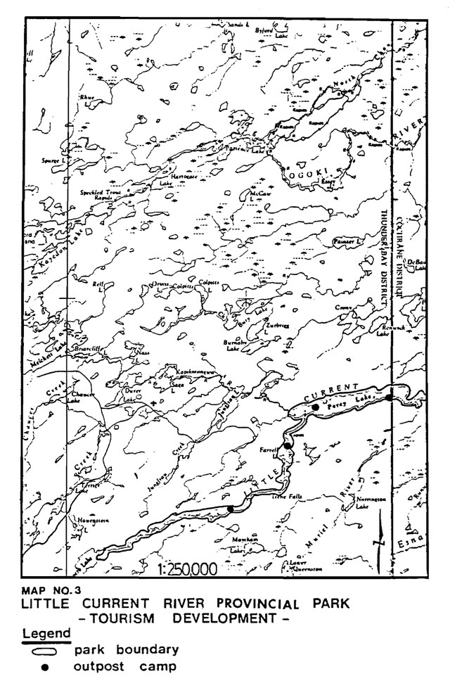
There are four outpost camps within the Park boundary, two on Percy Lake and one on each of Farrell and Two Mile Lakes (see Map No. 3). The camps on Percy and Farrell Lakes are fly-in access locations. The camp on Two Mile Lake is accessed by boat from the tourist camp on the Kawashkagama River. There are several commercial boat caches along the Park to ease the travel over the portages. There is no land tenure or authorization associated with these locations. In addition, the tourist operator on Esnagami Lake outfits parties who travel along the Esnagami River to the Little Current River where they are picked up by plane.
Guideline:
The outpost camps will be permitted to continue their operations. The boat caches by the commercial operator will be a permissible use, but no other commercial boat caches may develop until addressed in the Management Plan.
Aircraft landings will be permitted in the entire Park area. However, other than at the outpost camp locations, no additional docking facilities or associated uses will be permitted, pending the completion of a Management Plan.
Outpost camps may be transferred from one operator to another but no expansion of use is permitted pending completion of a Management Plan.
No additional commercial tourism development will occur, pending completion of a Management Plan.
Trapping
There are portions of five traplines within the Park boundary. There are no known trapper’s cabins although there may be some unrecorded locations.
Guideline:
Licenced commercial trapping will be phased out of all classes of Parks except for trapping by Status Indians. The phase out will occur by January 1, 2010 or when the trapper retires or dies, whichever is sooner. The phase out period is based on a reasonable time for a trapper to recover his/her investment/amortization and provides time to plan for retirement. Only Status Indians enjoying treaty rights will be permitted to continue commercial trapping in the Parks. Transfers of existing traplines inside Provincial Parks will only be allowed between or to Status Indians. Only Status Indian trapper helpers are permitted to assist Status Indian trappers.
No new traplines will be established in Provincial Parks. The transfer of traplines must be approved by the Ministry.
Where a trapper’s licence lapses, the licence will not be renewed.
Any existing trapping cabins will be permitted to remain, however all new developments will be encouraged to locate outside of the Park boundary.
Forestry
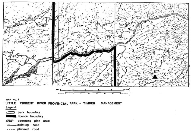
Little Current River Provincial Park passes through two management units, the Kimberly-Clark of Canada Incorporated Management Unit and the Little Current Crown Management Unit (see Map No. 4). The Little Current C.M.U. is not scheduled for harvesting in the foreseeable future.
Harvesting has taken place adjacent to the Park and more is scheduled to occur within the period of Kimberly-Clark’s operating plan (see Map No. 4). Road development (the Hauenstein and Farrell Road systems) is also occurring and will come to within 300 meters of the waterway at the closest point. The Hauenstein Road has been gated where it joins the Anaconda Road and this also controls access on the Farrell Road. The purpose of the gate is to ensure that the Terrier Lake gate is not circumvented and public access gained to the mining facilities at Melchett Lake.
Guideline:
No timber harvesting will occur within the Park boundary other than for use as firewood.
No road development will occur within, or across, the Park. The gate on the Hauenstein Road serves the Park management objectives at the present. The presence of the Park will be considered during any discussions to open the road to public travel.
In the event that the Hauenstein Road is open to public travel, access to the Park will be controlled as stated in Section II.
Mineral resources
The patented and leased land between Percy and Farrell Lakes covers an identified iron ore deposit. There has been some recent staking around the north end of Superb Lake but none has occurred within the Park area. The Park area is now withdrawn from staking.
Guideline:
Although the area covered by the leased and patented lands does not constitute part of the Park, should any development of the identified ore body occur, M.N.R. will attempt to protect the aesthetic value of the river system along this stretch.
New mining activity, including prospecting, staking of mining claims or development of mines will not be permitted in the Park.
VI-V Natural resources/cultural resources
Superb Lake has a lake trout population and there are many areas along the Park which have sensitive brook trout populations. No other sensitive areas have been identified.
No archaeological inventory has been carried out.
Guideline:
Sensitive areas will be recorded and appropriately managed as they are identified.
VIII Client services
The Little Current River is not documented as a canoe route and it is not listed in Ministry publications as Canoe Routes of Ontario.
Guideline:
Geraldton District will document the Little Current River as a canoe route. The information will be used to prepare a canoe route pamphlet for public distribution.
Geraldton District will request that the Little Current be listed in any subsequent canoe route publications.
Fire
Guideline:
Fires occurring within the Park will be managed according to the Regional Fire Management Policy.
Use of the Park for access to a fire will require the approval of the District Manager.
IX Research/inventories
N/A
References/sources
Ontario Ministry of Natural Resources. Map No.’s G-193, G-201, G-212, G-305, G-309, G-336, G-377, G-414, G-429. Scale 1" = 4 chains. 1981.
Ontario Ministry of Natural Resources. Trapline Map, Commercial Fishing Map. Scale 1:250,000. 1984.
Ontario Ministry of Natural Resources. Geraldton District Land Use Guidelines (unreleased). 1983.
Ontario Ministry of Natural Resources. Forest Resource Inventory Map No. 505863, 505864, 506861, 506862, 506863. Scale 1:15,840. Revised 1974.
Ontario Ministry of Natural Resources. Geraldton District Office Files, Geraldton. 1984.
Park Impact Assessment Sheet - Little Current River.
Appendix A: Little Current River Crown reserve inventory record
- District: Geraldton
- Name of area/reserve: Part of Little Current River
- Type (A, B or C): B
Order number (for type B & C): WRR-4: W64/75 - Land:
- Acres: + water 6,208
- Hectares: 2,512
Water:
Total:
- Acres: 6,208
- Hectares: 2,512
- Location description: Start Long. 86°29' Long. 85°20'
- Latitude:
- Longitude: 86°29' Start
- Map plan No.: T- M-
- Area name:
- Purpose of reservation: Wild River Park Reserve
- Date laid down (reserved): November 14, 1975
- Requested by whom (user group): Parks Branch
- Present use (A) same as No. 10 or same as No. 10
- Confirmation - site will meet criteria of purpose: Site meets criteria of purpose.
- General description of physical features:
- Topography: Information not available
- Forest cover: Jack pine, black spruce, white birch and poplar
- Soil depth & texture: information not available
- Wet beach: Sand and boulders
- Dry beach: Sand and boulders
- Means of access: Canoe or aircraft
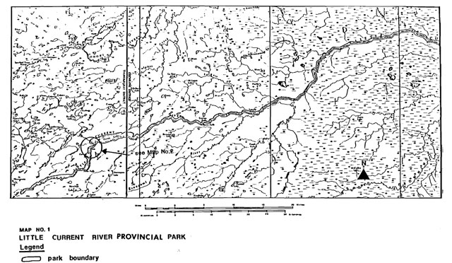
Little Current River Provincial Park map No. 1
Little Current River Provincial Park map No. 2 - Percy Lake area
Little Current River Provincial Park map No. 3 - Tourism development
Little Current River Provincial Park map No. 4 - Timber management