MacGregor Point Provincial Park Management Plan
This document provides policy direction for the protection, development and management of MacGregor Point Provincial Park and its resources.
Minister’s approval statement
Following a directive in 1972 from the Atomic Energy Control Board that camping would have to be phased out of Inverhuron Provincial Park because of the construction of the Bruce Nuclear Power Station, the need to develop a provincial park along the Lake Huron shoreline became apparent. For this reason and to satisfy the growing demand for recreational opportunities on Lake Huron, the decision was made to establish MacGregor Point Provincial Park.
In addition to providing year-round recreation, the establishment of the park protects representative and significant natural and cultural features associated with ancestral Lake Huron shorelines. I am pleased to approve this plan in accordance with Sections 1d and 7a of The Provincial Parks Act as the official policy for the protection, development and management of MacGregor Point Provincial Park.
As well, I would like to thank the Saugeen Township Council, and residents and interest groups, particularly those around Port Elgin, for their valuable contribution to the master plan through the public participation program. In addition, I would like to acknowledge the financial assistance provided by Ontario Hydro for land acquisition, planning and development related to the park.
Through the implementation of this master plan, I am confident that the natural and cultural attributes of the park will be protected and that a variety of recreational opportunities will be available to the citizens of Ontario and visitors to the province.
Hon. James A. C. Auld Minister
December, 1978
| Unit | Equivalent |
|---|---|
| centimetre (cm) | 0.3937 inches |
| metre (m) | 3.2808 feet |
| kilometre (km) | 0.6214 miles |
| square kilometre (sq km) | 0.3861 square miles; 100 ha |
| hectare (ha) | 2.4710 acres |
| cubic metre (cu m) | 35.3148 cubic feet |
| litre (l) | 0. 2200 gallons |
| kilogram (kg) | 2.2046 pounds |
| kilowatt (kw) | 1.3410 horsepower |
Master plan highlights
- The park will be designated as a recreation park under the Ontario Provincial Parks Classification System.
- The park will be operated on a year-round basis.
- The park will be divided into two zones a development zone and a natural environment zone. Resource management practices consistent with this zonation will be carried out.
- The campgrounds, which make up the recreational core area of the park and act as the focus for other recreational facilities and activities, are oriented towards Lake Huron.
- Access from the main recreational activity areas to the natural and cultural features of the park will be provided by a system of carefully designed and designated pedestrian and bicycle trails.
- Resulting from the physiographic constraints and the existence of sensitive areas within the park, facilities will focus on extensive recreational activities, such as hiking, nature appreciation and cross-country skiing.
- Significant geomorphological features (i.e. the Nipissing Bluff), and sensitive natural wetlands containing fragile plant communities and wildlife habitats will be protected and conserved.
- A visitor services program will be developed according to the guidelines outlined in the master plan.
- Resource management programs will be undertaken to ensure the presence of abundant wildlife in the park, such as deer, upland game and waterfowl.
- Park development will occur in two phases.
- The park theme will concentrate on the physiographic and ecological elements of this segment of Lake Huron and the Huron Fringe and their effect on historical and present-day settlement and transportation patterns.
- Certain areas and facilities will be designed to meet the requirements of the handicapped.
Introduction
The need for additional recreational development and camping facilities along the Lake Huron shoreline in Bruce County, became most apparent in 1972. Because of the location of the Bruce Nuclear Power Compleat Douglas Point, the Atomic Energy Control Board, in the interest of safety, issued a directive to phase out camping in Inverhuron Provincial Park. Consequently, the construction of MacGregor Point Provincial Park, 16 km to the north, became a priority in meeting the growing demand for camping and other outdoor recreational opportunities in this touristoriented region of Southern Ontario.
Part of the MacGregor Point landbase had been set aside by the province in 1968 in recognition of the need for the provision of increased access to Great Lake shorelines. Increased access would sustain public outdoor recreational activities, a measure made necessary by the rapid increase in private shoreline development, which was considerably restricting opportunities for public use of Lake Huron, especially in the Port Elgin, Southampton and Kincardine corridor. From the time of purchase, this block of undeveloped land was operated as a wildlife management unit to enhance the traditional hunting activities in the immediate area. Early in 1972, a preliminary analysis was undertaken to ascertain the capability of the MacGregor Point landscape to meet the requirements of the Provincial Parks System. During 1973, an inventory team consisting of two archaeologists, an historian, a geologist and an ecologist undertook numerous field surveys to identify interesting or sensitive areas that should be taken into account during the early stages of the master planning process for MacGregor Point.
The details of the agreement required between the Ministry of Natural Resources and Ontario Hydro are outlined in Appendix C. In summary, MacGregor Point Provincial Park was established to replace the 324 Inverhuron Provincial Park campsites, which were closed at the end of the 1975 operating season. Subsequently, Inverhuron has been operated strictly on a day-use basis free of charge to the public.
Following completion of the initial resource inventories and market area analyses, a draft master plan was compiled. This plan was reviewed by the Ministry of Natural Resources and presented to the Saugeen Township Council for comment. A public meeting was also held in Port Elgin to allow interested groups and individuals to make recommendations concerning the activities and development required at MacGregor Point Provincial Park. The plan was then rewritten with these comments in mind. The result is the present master plan, which will be reviewed and updated, as necessary, after a five-year period. In general, the plan calls for a low intensity, high quality recreational experience for visitors.
Purpose of a master plan
A provincial park master plan establishes detailed policy guidelines for long term preservation, development and management of a park. Within this context, the purposes of the master plan are:
- To define the role and significance of a particular park in relation to the total provincial parks system.
- To examine and ascertain the existing supply of recreational opportunities, the type and extent of facilities offered, transportation linkages and population projections for the surrounding market area.
- To analyze and identify resource values and the environmental limitations of the park property.
- To determine the appropriate classification and zoning system for the park.
- To define the goal and objectives that will establish the individual character of the park.
- To outline concept plan alternatives and recommend the plan to be pursued.
- To define visitor services guidelines and concepts.
- To establish management and site planning guidelines.
This master plan, as approved by the Minister of Natural Resources, will direct the development and management of MacGregor Point Provincial Park. In keeping with Ministry Policy, the plan will be reviewed at regular five year intervals.
Regional context
Resource characteristics and land use
MacGregor Point Provincial Park is an outdoor recreation area situated on the eastern shore of Lake Huron within the southwest corner of Saugeen Township, Bruce County. It is located at some distance from the major population centres and transportation routes of southwestern Ontario (Figure 1). The park lies within a part of the rural western area of the Georgian Bay region (TEIGA, 1972), which includes the counties of Grey, Bruce, Dufferin, Simcoe, Muskoka and Parry Sound. The western section (Grey and Bruce Counties) of this region is a territory historically dependent on agriculture, fishing and forestry. Today, it is still a rural landscape with much productive crop-growing and beef cattle-raising farmland, as the soils in this region are well suited to general agriculture. However, abandoned farms are common on some of the scattered sections of rugged terrain and less fertile soils. Although commercial fishing remains a minor influence on the economy of the area, sport fishing has increased and has become a major attraction and consequently, an important asset to tourism in this part of Southern Ontario. The lumber industry has declined because of poor management and overcutting of the forests.
One of this area’s greatest assets is its natural environment. North from MacGregor Point Provincial Park tourism, a major industry, is generated by the existence of sand beaches, rocky headlands, lookout points and clear waters along the Lake Huron and Georgian Bay shorelines. The prime recreational waterfronts, centred around Sauble Beach, attract considerable camping and day-use. From here, the clear water extends around the Bruce Peninsula, inclusive of the waterbase of Fathom Five Provincial Park. This entire area is expected to continue to attract a predominance of nature-oriented users, especially from the Toronto, Kitchener-Waterloo and London centres, as it contains some of the most scenic spots in Ontario. In addition, Lake Huron is one of the few shorelines in the entire Georgian Bay region that can still accommodate more recreational development. Population in the western section of the Georgian Bay region followed a downward path during the first half of the 20th century. Since 1951, it has shown a slight increase, and over the past ten years it has been accelerating fairly rapidly.
The main reason for the latest increase relates to the 1959 arrival of the Douglas Point Nuclear Power Centre and the Bruce Nuclear Power Centre in 1967. Owen Sound, the largest urban centre in the area has a variety of manufacturing industries as well as professional arid business services, shopping malls and a major general hospital.
The smaller towns and villages within the area have developed as service centres for the tourist, the farm community and locations for small manufacturing companies. Although trends toward urbanization (Kincardine, Port Elgin and Southampton) of the countryside are apparent, Bruce County still maintains a pleasant rural atmosphere.
Population centres
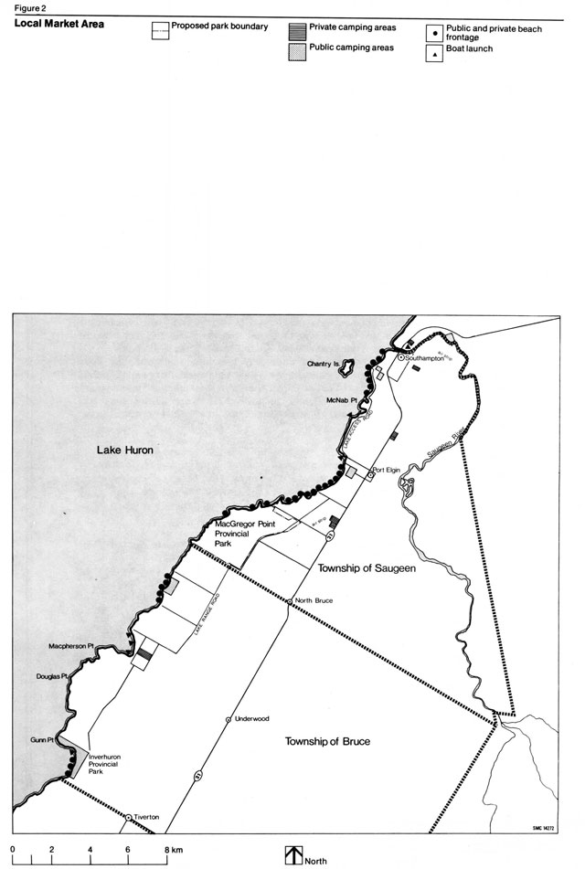
Port Elgin, a town of just under four thousand people, is the closest urban centre to MacGregor Point (Figure 2). It lies approximately 5 km northeast of the park off Highway 21. Port Elgin, which initially developed as a port for Upper Great Lakes Shipping, is today a tourist-oriented as well as a rapidly developing residential community. Consequently, it is expected that the local merchants will have no trouble in coping with the influx of additional business created by the development of MacGregor Point Provincial Park.
Southampton’s early development paralleled that of Port Elgin, but ultimately it failed to compete with the faster developing harbours of Kincardine and Owen Sound as a result of physical limitations which constrained port developments. It is the second nearest urban centre to the park lying 9 km further north of Port Elgin. Southampton’s population is just over two thousand.
The towns of Southampton and Port Elgin are two of the four communities along Lake Huron most directly affected by the Bruce Nuclear Power Development. Their share of the Primary Urban Community population (Official Plan for the Bruce County South Planning Area, (Draft) 1975) is expected to increase by eight percent between 1974 and 1978.
Access
The park is within a relatively short travelling time of sizeable population areas. Communities to the south have direct access to the park by way of Highway 21 and from the west by Highways 4, 8 and 21. Those travelling from the Hamilton, Toronto, London and Windsor areas to the park have a more time consuming journey resulting from passage through and around small towns and villages on minor highways as well as larger urban centres on the major travelled routes.
During the summer months, nearly doubled traffic volumes attest to the heavy recreational use of roads within the MacGregor Point area. Traffic congestion is not a problem except during periods that correspond to shift changes at the Bruce Nuclear Power Centre.
The 1966 regional highway traffic study recommended the provision of an arterial highway between the highly populated Regional Municipality of Waterloo and the Port Elgin-Southampton tourist region.
If this construction and upgrading of the existing roads are carried out, the route will vastly improve access to the park.
Although a local bus line travels daily past MacGregor Point on Highway 21 to Toronto, it is not anticipated that many park visitors will use this service. Access is also possible via a grass strip airfield situated 0.8 km east of the north eastern corner of the park. At present, it is mainly used for local recreational flying. Port Elgin, with its large harbour, is a popular stopover point for boats cruising on Lake Huron. Again, however, boating is not expected to be a significant mode of travel to the park.
Park area
MacGregor Point Provincial Park is bounded by the lake to the west, the township line between Bruce Township and Saugeen Township to the south, the Lake Range Road to the east and part of Concession IV and Lot 20 of Saugeen Township to the north. Although the complete park property will eventually include approximately 1,050 ha, it presently contains only 433 ha. The park will be fully developed in stages once the land base is completely acquired. Future park expansion, if desirable, must be southward along the shoreline into Bruce Township, where, to date, the land has not been subdivided. Such action is not recommended for the immediate future.
Two Saugeen Township road allowances cross the property. One is the extension of the second concession road, and the other is the 20-m right-of-way along the water’s edge. Neither road has ever been approved for vehicular traffic, although sections of the old shore road do follow the township allowance.
Residential holdings include a cottage subdivision on the shore of Lot 12 and Lot 13, another summer residence on the shore of Lot 6 and two cottages on Lot 20 along the fourth concession road. The existence of the cottage subdivision is the main factor restricting optimum utilization of the park in the future. All private cottage lands and buildings within the proposed park boundary will eventually be acquired. Life leases will not be granted to the owners, but short term leases are acceptable during the cottage acquisition program or as deemed necessary by provincial park policy. When the cottages have been acquired, several hundred kilometres of beach will become available to general park users, and the expansion of camping opportunities will be possible. Until that time, an agreement, as outlined in Appendix C, has been drawn up between the MacGregor Point Cottagers Association and the Ministry of Natural Resources to control access for cottagers, their guests and park visitors.
Except for these seasonal residential homes, recent use of the park property has been minimal. Minor logging and wood cutting, especially in Lot 10, Lot 11 and Lot 20, have been carried out. Hunters in search of waterfowl, upland game and deer, in season, have made light-to-moderate use of the MacGregor Point area. In recent years, snowmobile enthusiasts have used the park site considerably during the winter season.
In 1975, MacGregor Point Provincial Park became subject to regulations under The Provincial Parks Act to be managed as a recreation park. On November 6, 1975, the then Minister of Natural Resources, Leo Bernier, announced that the park would be open for camping by July 1, 1976, at which time about 150 campsites would be available to the public, with a further 200 campsites scheduled for completion by midsummer. The Minister also stated that the new park, when completed, would contain more than four times the area of Inverhuron Provincial Park, thereby expanding day-use and camping opportunities for the 4,000,000 Ontario residents who live within a three-hour drive of this part of Lake Huron’s scenic shoreline.
Market analysis
Market areas
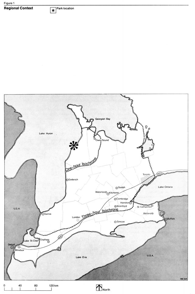
A primary market area and secondary market area have been designated for outlining the existing and proposed recreational facilities within the MacGregor Point Area. The former area includes the land demarcated by the one-hour isochrone and is equivalent to the area that will generate the majority of day-use visitors for the park. The latter area is bounded by the three-hour isochrone and is the user-area from which most campers can be expected to originate (Figure 1).
The primary market area includes Saugeen Township and Bruce Township. This immediate area was chosen because the wide variety of excellent beaches and other facilities existing on the land base defined by the day-use isochrone will undoubtedly attract some potential users away from the low capacity beaches at MacGregor Point. Exclusive of the MacGregor beaches, several thousand metres of public beach currently exist, particularly in Saugeen Township. However, although the townships own a 20-m wide road allowance along most of the shoreline, only portions of the shoreline are readily available to the public.
Other problems related to the use of public beaches in this area are a lack of parking and unsatisfactory sanitary facilities. While no figures presently exist to indicate the level of recreational use of the township’s public beaches, it is safe to assume that they experience heavy usage when the local population doubles during the summer months.
Local public and private camping areas are shown in Figure 2. Eight of these camping areas together provide approximately 494 public and 495 private campsites. The majority of the municipal and Private campgrounds are fully serviced. They cater to social or stopover camping and are generally crowded. Travel trailers occupy many of these sites on a regular yearly rental basis. Two camping facilities, the River Vue Tourist Camp and the Denny’s Dam Conservation Area, have recently been developed north of the Saugeen River on the periphery of this market area. Both of these campgrounds, which together provide 325 sites on approximately 5.3 ha, are used primarily during the spring and fall when fish runs occur in the Saugeen River.
The availability of both public and private campsites is limited, and minimal expansion is planned within the latter group. This, plus the fact that the Inverhuron campgrounds were closed after the 1975 operating season, led to the conclusion that any increased recreational camping opportunity within the primary market area would be limited to MacGregor Point Provincial Park.
The analysis of the secondary market area places special emphasis on the Owen Sound Administrative District of the Ministry of Natural Resources by comparing it to the rest of the province. Only provincial parks are considered within the comparison.
Approximately two-thirds of the Owen Sound District is bounded by Lake Huron and Georgian Bay waters. The District can be separated into three fairly distinct sectors: the southwest, the Bruce Peninsula and the southeast. The first sector is Lake Huron-oriented and extends from Point Clark to Oliphant. Its prime recreational features are sand beaches, which attract a majority of users from southwestern Ontario. Inverhuron, Sauble Falls and MacGregor Point are the three provincial parks in the southwest division.
The Bruce sector is the part of the peninsula north of Wiarton. Possessing a variety of provincially unique features associated with the Niagara Escarpment and the Lake Huron shore, it attracts visitors from the entire province as well as visitors to the province. At present, provincial parks within the Bruce sector include Cyprus Lake and Fathom Five. The last sector is dominated by the Niagara Escarpment. It has the greatest potential for sustaining fairly extensive year-round us The southeast sector currently includes only Craigleith Provincial Park, but this area will undoubtedly rival the Bruce sector in recreational growth over the next 20 years.
Of the 13 existing provincial parks within the three-hour travel time area, 11 contain campgrounds. Although the July-August percentage occupancy rate for 1975-77 varied from a low of 37 percent at Devil’s Glen to a high of 93 percent at Bass Lake, the average occupancy rate was about 70 percent. Two recently planned provincial parks, Boyne Valley and Mono Cliffs, will contain some facilities for camping once park development takes place. The preliminary master plan for Boyne Valley recommends the development of 600 campsites. At Mono Cliffs, however, emphasis is placed upon the development of a trail-oriented day-use recreation area providing for only 50 walk-in campsites.
Based on the 1974 TEIGA census, populations within the primary and secondary market areas of MacGregor Point Provincial Park include 89,000 residents within the day-use isochrone and 4,700,000 within the camping-use isochrone. While the secondary market area includes the highly populated areas of Toronto, Hamilton, London and the Waterloo-Kitchener-Guelph-Cambridge centre, it is significant that the secondary market area does not reach the United States border. Population growth of centres within the market area is rapid, particularly in the metropolitan Toronto area. The trend for regional population growth is illustrated by the 1976, 1981 and 1986 population projections, which indicate an expected increase within the primary market area from 87,723 to 92,338 to 101,618 persons and within the secondary market area from 4.9 million to 5.3 million to 6.0 million, respectively. While the percentage increase for this period within the primary market area is 13.7 percent as compared with 18.3 percent in the secondary market area, these figures do not totally account for the high population increase in the immediate MacGregor Point area (Kincardine to Southampton), which is a direct result of the Bruce Nuclear Power Development at Douglas Point. From 1974 to 1981, the population in the three townships of Kincardine, Saugeen and Bruce is expected to increase from approximately 16,000 to about 20,000. Four urban-centred regions, Sarnia, London, Kitchener and Oakville, as defined by Vrancart (1970), fall partially within the camping isochrone of MacGregor Point. According to Vrancart’s second alternative, which involves sustaining the present size of the market served by the province and allocating future growth to deficient areas, Windsor and Oakville indicate a net need for additional campsites by the years 1976 and 1981. While the Oakville-centred region requires the greatest proportion of additional camping facilities, that is, 15,803 sites, it is expected that several proposed parks within the southern part of the Niagara Escarpment will provide for much of this demand. However, by 1981, the Kitchener, London and Oakville-centred regions will require an additional 38,000 campsites.
Apart from the fact that MacGregor Point was initially proposed to replace the campsites at Inverhuron, it is evident from the market analysis that camping would be emphasized at this park. MacGregor Point lies within two market areas that are experiencing rapid population growth, which will continue in the immediate future. Camping continues to be popular, as indicated by the higher than average July-August occupancy rates for provincial parks in this area as compared to the latest provincial average of 62 percent.
In addition, MacGregor Point offers an alternative to the high density, socially-oriented opportunities for camping available in the immediate area of Port Elgin, Southampton and Kincardine. MacGregor Point will not appeal to the highway stop-over user, but to those desiring a destination user-oriented camping experience. While MacGregor Point cannot substantially eliminate the overall lack of campsites in Southern Ontario by 1981, it can alleviate a small percentage of this deficiency.
Park use and user projection
For many years, except for minor annual fluctuations, the use of provincial parks has been growing steadily. Variance in park use can generally be attributed to a combination of poor weather, shortterm reaction to fee increases the conservation of fuel and the shorter work week.
The classification of five provincial parks in the Owen Sound District includes two recreation parks, Sauble Falls and Craigleith, and three natural environment parks, Cyprus Lake, Inverhuron and Fathom Five. Visitation at these parks has increased remarkably in the last few years, partially in response to publicity about the Niagara Escarpment and the Bruce Peninsula. Statistics for these Owen Sound District parks do not indicate a shift in popularity from recreation to natural environment parks or vice versa. The Owen Sound District is maintaining a slightly higher camper day-campsite ratio than is prevalent within the rest of the province. Inverhuron Provincial Park user statistics can be utilized to identify the characteristics of potential users at MacGregor Point. Camper surveys have shown that Inverhuron is primarily a destination park for family campers from southwestern Ontario. The majority of users own their own residence and are quite well educated. The average camper age grouping by comparison with the provincial average indicates a somewhat higher proportion in the under 12 group, as shown in the following table:
| Location | 1-12 Age Group | 13-19 Age Group | Over 19 Age Group |
|---|---|---|---|
| Inverhuron camper age group | 36 percent | 10 percent | 52 percent |
| Provincial camper age group | 30 percent | 14 percent | 55 percent |
Source: Ontario Provincial Park Statistics 1974-75
Tent-trailers are the most popular form of camping equipment used, with tents almost as popular. House·trailers and camper-backs are a distant third. Only eight percent of the campers bring boats to the park, and one-half of these are canoes.
Park use in the Owen Sound District can be expected to continue to grow. The development of several new parks on the Niagara Escarpment should not affect the growth of parks on Lake Huron, because the majority of users of these latter parks originate from southwestern Ontario, rather than from the Hamilton-Toronto area.
The number of camper days in the Owen Sound District has increased more than five-times in the past 10 years. Straight line projections from such statistics would be somewhat speculative, but an expected doubling of use over the next three years is not an unrealistic anticipation. The existing park facilities would be unable to accommodate this increase. It should be noted, however, that the MacGregor Point area will probably not see such a substantial rise in use in the immediate future, because much of the increased demand will initially occur north on the Bruce Peninsula. The Ministry of Natural Resources and the Grey Bruce Tourist Council monitor the factors closely and make recommendations concerning their findings both to the Ministry of Natural Resources and to private industry.
Biophysical resources
The identification and analysis of the biophysical elements of a park help to determine the future development themes which will be compatible with the site’s natural and cultural resources. Resource analyses carried out within MacGregor Point during the late summer and fall of 1973 indicated a lack of biologically, geologically or geomorphologically unique features of provincial significance. The park land base is characterized by little variation in relief or overstory variety of mature tree species (Cuddy, 1973). However, the extensive forested land, wildlife populations and certain plant communities have a regional and local significance. The site is also important at this level because it constitutes a good representative example of the Huron Fringe, a physical sub-unit (Chapman and Putnam, 1966) composed of an area between the ancient Lake Algonquin shoreline and the present Lake Huron shore. Because the essential features of this lake plain are well preserved and occur in close proximity to one another, the opportunity for interpretation of changing lake levels in the Huron Basin is quite good.
Geology and geomorphology
The Palaeozoic sedimentary rocks underlying MacGregor Point are a Middle Devonian formation referred to as the Bois Blanc limestone. Structurally, this material, as part of the Michigan Basin, appears to be a western equivalent of the Onondaga Formation of New York State. Within the park, this chert rich, highly fossiliferous limestone only outcrops along the Lake Huron shoreline (Warren 1973, p. 4) and has little influence on the surface features elsewhere. The best exposures of Bois Blanc limestone boulders occur in the small bays south of MacGregor Point (Warren 1973, p. iii). Bedrock outcrops are generally a controlling feature of the shoreline configuration with its many points and bays.
The geological features within the park, such as the Nipissing bluff, Algoma shoreline, Lake Huron shoreline, boulder pavement and sand plains, are representative of the Huron Fringe (Figure 3). The sand, gravel and cobble beaches and the marly bays characteristic of the present shoreline act as interpretive aids from which the geomorphic evolution of bluffs, beaches, swamps and boulder pavement of the inland lake plain can be discerned.
These features resulted directly from a process involving the succession of high post-glacial lake levels first depositing and then eroding a thick bed or clay and boulder-rich glacial till. These features and the resultant physiography are associated with the retreat of the Wisconsin ice sheet (13,000 years B.P.) into the Huron Basin.
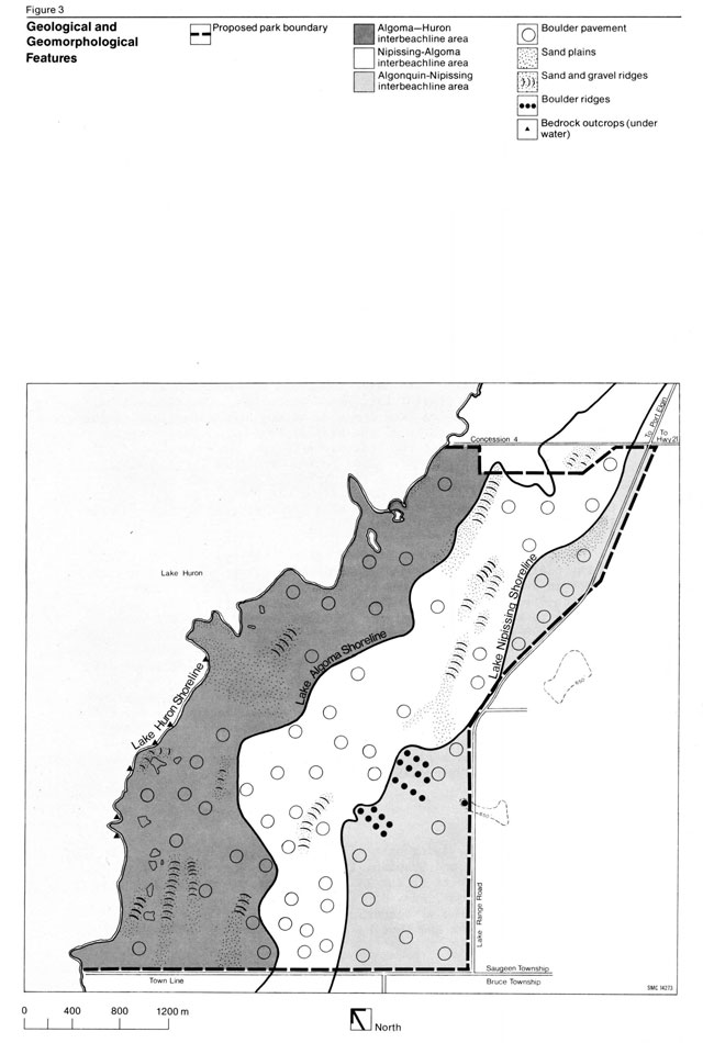
The first glacial lake stage to affect the area (Warren, 1973, p. 15), Lake Algonquin (12,000 years B.P.), left a steep erosional west-facing slope, which averages 30 m in height. Although this prominent bluff lies 1.6 km east of the park boundary, it dominates the topography of the region and is the best site example of the initial development and preservation of this feature in the entire Huron Basin. Below this bluff and extending into the park is an undulating lake plain dominated by boulder pavement, a feature created as a result of wave action on the underlying till plain material. Because of the clay deposits that are often intermingled with the boulder pavement, the lack of relief and the scattered boulder ridges, the Algonquin Plain exhibits extensive poorly drained areas.
As the ice continued to retreat north from this area, the Lake Nipissing stage (stabilized around 5,500 B.P.) was initiated.
It, too, cut into the till plain. In contrast to the Algonquin shoreline, this is a relatively minor erosional beach terrace which averages 4.6 m to 6.1 m in height. Within the park, this feature extends from the north to the south boundary and provides the greatest relief on the property. The major headlands or points in this bluff roughly parallel the present Lake Huron shoreline. The almost 1 km - wide lake plain extending from the base of the Nipissing bluff to the present beach is indicative of the gradual retreat of the shoreline into the Huron Basin over the last 4,000 years. Although its features are of greater variety and better preserved (Warre 1973, p. 21) than its older counterpart, the Nipissing lake plain exhibits the same poor drainage as the upper Algonquin Plain. It is, nevertheless, an excellent example of a beach erosion feature (Warren, 1973, p. 21).
A discontinuous variety of sand, gravel and boulder ridges left on the plain by receding shorelines reflects either storm beaches or pauses in the retreating shore front. The largest beach ridge, although discontinuous within the park, (Warren 1973, p. 23), is believed to represent Lake Algoma (3,200 years B.P. to 2,500 years B.P.), a 700-year stationary phase in the lakeshore’s retreat. It is approximately 180 m above sea level in the MacGregor Point area. These beach ridges, together with the ancient shorelines, lake-bottom soils and gentle slope of the land, impede natural drainage courses by impounding the surface waters within the areas between the beachlines.
Ponds or damp depressions which dry out by mid-summer occupy one-third of the lake plain’s surface. Permanent ponds, which are a further expression of poor drainage, are a combination of open water and grassed-over muck and marl. Farther inland, these areas are covered by more vegetation (Warren, 1973, p. 38).
Climate
MacGregor Point, lying within the Lake Huron-Georgian Bay climatic region (Brown, McKay and Chapman, 1968), is heavily influenced by the ameliorating effects of the lake. Temperature extremes are less than at inland stations, and, in fact, this region experiences the lowest mean daily range of temperatures in Southern Ontario. The mean date of the first and last snow cover is November 18 and April 8, 17 respectively, with an average of 266.7 cm falling throughout the winter. As no weather station exists at MacGregor Point, climatic data for the park site has been derived from a nearby geographically similar location, the Douglas Point Weather Recording Station, known since 1970 as Bruce Ontario Hydro. Most data used is taken from the period 1961 to 1974.
Weather at a park is one of the most critical factors influencing the pattern of visitation. This point is illustrated by the Ontario Provincial Parks Statistical Report, 1972. This report indicated a fairly large province-wide decline in the number of campers, camper days and July-August occupancy rates for that year, a summer of cool, wet weather, in contrast to the almost continual increase in these statistics from 1963 to 1971. This pattern was also evident at the park specific scale. Inverhuron, which was used in the market analysis as an indicator of potential MacGregor Point visitation characteristics, showed a major decrease in camper days and occupancy rate in 1972. The prime causal factor is deduced to have been that the mean summer precipitation, June through September, which is usually 34 cm increased to 50 cm for the four month period, while the mean daily summer temperature dropped 1.1°C.
The dominant visitation period at MacGregor Point is expected to occur during the summer season. The average mean maximum temperature during the summer is 21.1°C, a pleasant daytime temperature for the camping enthusiast, sunbather, angler or hiker. The average mean minimum temperature of 13.3°C provides an indication of the level of night temperatures to be experienced at the park. The mean annual percentage of total daylight hours with bright sunshine is 43 percent. Precipitation in this area, which annually averages about 91.4 cm, is fairly evenly distributed, with a slight concentration occurring in the fall and winter seasons. For July and August, the mean monthly rainfall total is 6.5 cm and 7.6 cm, respectively. The winds during the late spring and summer months are the lightest experienced in the year and are off the lake. These light breezes, with speeds averaging between 13.5 kmph and 14.6 kmph , alleviate oppressive temperature and humidity conditions for the most part. Although the prevailing wind direction is from the west, higher wind velocities, especially from the northwest, can occur. Thus, pleasant summer weather conditions are conducive to the enjoyment of numerous outdoor recreation activities at MacGregor Point.
Winter weather is also favourable for some outdoor recreation sports. The mean maximum temperature for this season averages -6°C. Although snowfalls are sufficient for participation in many winter recreation activities, because of a mean annual total of 120 days with snow cover, wind velocities can be somewhat problematic.
Soils
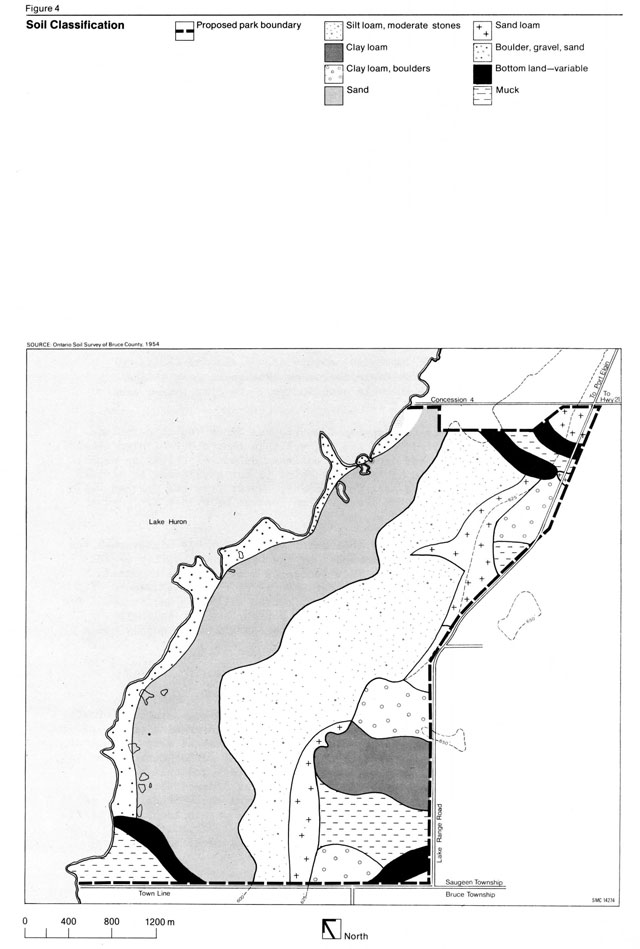
The soils of MacGregor Point Provincial Park are predominately sands and gravels, with numerous clay-loam lenses derived from lacustrine and alluvial reworking of the underlying clay-rich till.
Subsequent soil forming processes have acted on these materials to produce the existing soil types (Figure 4). The surface veneer of soil is generally shallow over the poorly drained glacial till, especially above and just below the Lake Nipissing shore bluff.
The Soil Survey of Bruce County (Hoffman and Richards, 1954), indicates two major soil series in the park below the Nipissing bluff. These are a stoney phase of the Parkhill silt-loam belonging to the Dark Grey Gleysolic great soil group and the plainfield sand series. Several less extensive soil types include mainly mucks, sands, gravels and loams. Above the Nipissing bluff are a variety of generally poorly drained clays, loams, clay loams and mucks.
Hydrology
MacGregor Point occupies an exposed position on the highly erosional shoreline of Lake Huron, where prevailing winds are from the west, and currents are from the southwest. In this area, the Huron Fringe is bordered by an irregular shore cliff created by previous glacial lake activity. Although there is little terracing below this shore bluff, the prevailing surface water currents sweep along the shore, carrying the finer material to the north and causing sand to accumulate sparingly in the sheltered bays. Narrow strips of beach also occur on the south side of headlands which jut out into the lake. One headland in particular, extending 0.4 km into the lake just north of the MacGregor Point itself, obstructs currents and forces them to slow down. The resulting deposition of part of their load at the head of the point and on the south side creates beaches. Lake Huron is continually shaping parts of the immediate shore through storm and ice action. The extensive offshore shallows caused by shelving bedrock and numerous boulders act as a partial protection preserving the immediate shoreline. Nevertheless, with a strong onshore wind there is both moderate to heavy wave action and a strong seiche.
The lake water in the vicinity of the park is quite pure and clear according to the Ontario Water Resources Commission survey of Saugeen Township (1969). Two stations tested off MacGregor Point revealed total coliform counts of only zero and two. By contrast, the Lake Huron water off Port Elgin and Southampton was reported to be the most contaminated of the entire Bruce County shoreline, but it was expected to show improvement following the installation of municipal sewage systems in both towns.
Field studies uncovered substantial amounts of organic detritus on portions of the beaches. This may pose a minor problem if it is of a recurring nature. In general, the water off the park property is clear and cool with sufficient circulation.
As described in the geomorphology section, several permanent and semi-permanent ponds lying adjacent to the present shore result from the construction of storm beaches. General characteristics of these ponds or depressions include flooding and inundating at high water levels, high susceptibility to flooding by seiche currents and changing water levels of up to 0.6 m or 0.9 m in response to shifting winds. In dry years, only two or three of these landlocked ponds retain water all year round.
There are numerous seasonal streams within the park, but only one permanent stream, which flows out of the millpond in Lot 18, on the south side of the Lake Range Road, crosses under the road and flows through the extreme northeast corner of the property. While the gentle gradient and flow limit its erosive power, gullying by this stream has caused a deep indentation of the Nipissing bluff (Warren, 1973, p. 34). The gully nearly reaches the Lake Range Road. This is the only major modification of the Nipissing bluff within the park property. The stream, fed by springs below the bluff, is a cold water stream which supports trout. The major intermittent stream drains the beaver ponds at the southwest corner of the property. The other small intermittent streams drain ponds adjacent to the shore.
Because of the impervious nature of the glacial till, an apparent perched water table is common throughout much of the park. A perched water table also occurs where clay lenses rest on the unconsolidated till.
Water sources for Saugeen Township and Bruce Township include sand points, drilled wells and dug wells in that order of significance. While sand points are one of the easiest methods of obtaining water, the supply available at MacGregor Point is not sufficient to sustain the requirements of a park development. Water from the drilled wells is quite hard, having an average iron content of 0.15 p.p.m. and an average hardness of 700 p.p.m.
The phenol content of this water is considerably higher than the maximum of 1.0 p.p.b. recommended by the OWRC (now Ministry of the Environment) 1969 report. This indicates a minor petro-chemical problem evidenced by the fact that when added to a small amount of chlorine, it produces a taste effect. Three wells dug during the development of Campground A indicated a high level of magnesium sulphate in that area. As a result, the park’s water supply comes from the lake.
Vegetation and wildlife
MacGregor Point is covered largely by mixed regenerating forests, with white birch, trembling aspen and white cedar growing on the ridges, while ash and balsam poplar occupy the poorly drained areas. Much of the aspen-birch forest appears to be undergoing replacement by the more shade tolerant species, such as white cedar and balsam fir.
Above the Lake Nipissing bluff, on the better drained sites, maple, ash and beech predominate. Although the sugar maple-beech hardwood forest is supposedly the dominant forest type within the Huron-Ontario Great Lakes St. Lawrence Forest Region (Rowe, 1972), within which the MacGregor Point area lies, a combination of factors, such as high water table or poorly drained soils, dry nutrient deficient soils or browsing by deer populations, seem to prevent the widespread regeneration of these species.
Evidence of past human habitation is apparent from numerous apple trees and clearings on the dry beach ridges. The entire property at one time was logged. Some areas were cleared for cultivation. The presence of charred pine stumps provides proof of past fires although it seems that, in the past as today, pines were only secondary species in the forest composition.
The five vegetation complexes of forests, parklands, shrublands, grasslands and non-flowering plants (Cuddy, 1973) which have been identified in MacGregor Point Provincial Park are illustrated in Figure 5. Although distinctive plant communities have been listed within these complexes, there is considerable integration of many of the plant communities in the field.
The most interesting plant communities are within those complexes associated with the ponds, marshes and, to a lesser extent, the sand dunes near the lakeshore. The ponds show a successional gradient from open water, with abundant marl forming algae through sedge marsh and shrub phases to closed black ash and silver maple swamps. Two ponds near the north end of the park boundary are of interest. In one, abundant pitcher plant and sundew grow in marl among frost-heaved boulders, while an acid royal fern mat and basic sedge fen grow in the second. A small cool bog with sphagnum moss and black spruce is located farther inland below the Nipissing bluff. A stream arising from the Campbell mill pond is spring-fed in this area and winds through the bog. A beaver pond, containing a cattailwillow-cottonwood swamp complex found only in the south part of the property, sustains wildlife. Although these plant communities are not provincially significant, they are of site specific interest and consequent value to the park. For this reason and because of their inherent ecological fragility, some of these wetland communities should be protected.
Because of the variety and youthfulness of much of the vegetation, as well as the fact that this area has remained relatively isolated from human habitation, the entire park property contains abundant wildlife (Cuddy, 1973, p. 36). The young forest, with a variety of old fields interspersed throughout, provides good summer range for white-tailed deer. Other common animals include rabbits, hares, raccoons, squirrels, chipmunks, porcupines, woodcock, snip and foxes. There is an active beaver pond in the southwestern corner of the property, and muskrats are found in association with many of the small ponds in the park. There is a minimum of 105 bird species in the MacGregor Point area (Cuddy, 1973). Grouse are abundant in the aspenbirch parkland area, while woodcock prefer the wooded swamps and thickets. Puddle ducks, namely teal and mallards, are known to nest on the park’s inland ponds. Diving ducks are quite common along the shoreline during the spring and fall migrations. Numerous song birds also find the park an excellent habitat for feeding and nesting.
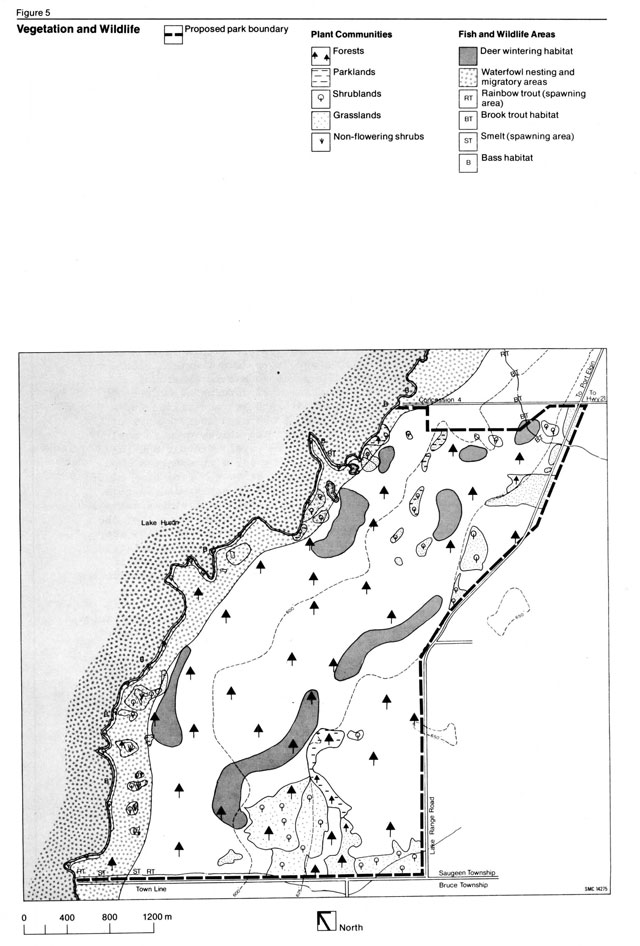
Hunting has been a common recreational pursuit in this area since the days of the early settlement. The deer population is represented along with other game species (Cuddy, 1974). The deer hunt in the fall of 1973 harvested approximately 20 to 25 deer and generated an estimated 300 hunter-days of recreation over a threeday period.
A small cold water stream in the northeast corner of the property contains speckled trout. Smallmouth bass are the most common game fish occurring within the section of Lake Huron adjacent to the park. Carp have successfully spawned in a pond at the northeast end of the property. Rainbow trout are often observed in the small inlets leading from the lake into small ponds along the shoreline. For both game and non-game species, habitat improvement should be considered in the management of the park.
Cultural resources
Historical context
Although MacGregor Point is not a great historical landmark, it does present some special opportunities within the southwestern Ontario parks system for the historical interpretation of several sites (Figure 6). The features are representative of an agriculturally settled area, which is located on poor land, but which is in close proximity to two ports on Lake Huron. The park lies in an area which was the northwestern “frontier” of Southern Ontario during the last half of the 19th century.
Prehistory
Archaeological studies within MacGregor Point during the summer of 1973 uncovered a large number of quartzite and a few chert flakes in a cultivated field on Lot 13 near the edge of the Nipissing bluff. The surface finds were identified as material from an Early Archaic site. While these artifacts are not related to hunting, it is speculated that they portray a vegetal food gathering, fishing or hide processing station. The occupation of this flat area was probably of short duration or of a recurring nature, because the soil, which is basically clay, causes excessive wet conditions, which would preclude continual habitation. Occupation of this site may have been contemporaneous with occupation sites to the north and south of the park.
While no other trace of prehistoric settlement was discovered during the original archaeological investigations, the survey team believes that an indefinite number of small temporary habitation sites and special activity sites inevitably once existed, especially in the location of the Nipissing bluff. However, pending an additional research program, the present evidence suggests that the prehistoric archaeological resource potential of MacGregor Point is minimal.
Early settlement history
The MacGregor Point area is an historically settled farm community strongly influenced by factors relating to local conditions of terrain, the development of transportation and communication and the establishment and growth of two fishing and commercial ports. Although European activity was present occasionally during the fur trade era, the first permanent occupation did not occur until 1848, when the Queen’s bush, a tract of some 40,000 ha lying between Huron County and the Saugeen River, was opened for settlement. Needless to say, an early survey which described this area as an extensive cedar swamp did not help to attract great numbers of settlers to Saugeen Township. The situation was not aided by the fact that the township was in a remote location and was the northwest boundary of Bruce County for many years. The late arrival of good road and/or railroad transportation networks, especially when areas to the south and east had these facilities at a much earlier date, was a further constraint to development in this area.
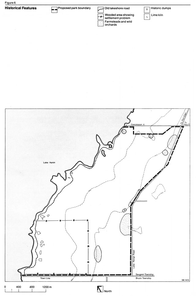
As agriculture expanded during the second half of the 19th century, the developing ports of Port Elgin and Southampton created a second economic interest. Large sums of money were spent by the federal government to improve harbours for coastal and trans-lake shipping. With the advantages associated with water-based transportation, Saugeen Township became the most densely settled area in Bruce County during the 1860s. Although road transportation had minimal effect on early trade or settlement, the first road through MacGregor Point still exists along the lakeshore. For years, this old shore road provided the only land route between Southampton and Kincardine. The arrival of the railway in the 1870s superceded the effect of road transportation, and the local economy rapidly diversified from the initial preoccupation with fishing and agriculture. Rail service is also believed to be responsible for the establishment of summer tourist recreation, as well as a fall recreation season for those who came to hunt deer and waterfowl in the MacGregor Point area.
Unfortunately, the anticipated development of Port Elgin and Southampton never transpired for several reasons. Their location proximate to one another caused the two ports to be competitive within an all too limited market area. Their harbours declined with the end of the sailing ship and were insufficient in size for large steamships. In addition, the adjacent shoreline made approaches harzardous for shipping. Shortly after World War I, a local depression led to a decline within the area.
Within the MacGregor Point area, the historical resource inventory identified six historical themes which relate to the Historical Systems Plan for Ontario, 1973: European settlement, transportation, fisheries, ports, fur trade and recreation (Greenland, 1973). The physical representation of these themes within the park, as evidenced by the mill and millpond on the Campbell farmstead, an old lime-kiln and former dumps and orchards, the lakeshore road, shipwrecks off the point, beaches, deer yards and waterfowl migration are important locally and should be preserved and enhanced as part of the park’s interpretive program.
Environmental assessment
An evaluation of the environmental limitations of the park and an assessment of their impact upon development through an analysis of the land base under the following development constraints is important to the master planning process: sensitive areas, physiographic constraints and capabilities of developable areas. Sensitive areas are those features of the park which are considered to be both significant in value and sensitive to intensive use. Physiographic constraints include the physical parameters, such as swamps and shallow or stony soils, which impede park development. Capabilities of developable areas provide guidelines for site planning and an overview of the intensity of development (e.g. measurements related to beach size or the percentage of area of campgrounds which are potentially developable (Figure 7).
Sensitive areas
Geology
While the majority of geologic and geomorphic features are intrinsically durable, they can be destroyed by massive earth removal, as in the case of sand and gravel quarries. The more sensitive geomorphic features at MacGregor Point include the raised beaches and beach bluffs. The Nipissing beach bluff, in particular, because of its very steep slope and clay loam mixture, should not be disturbed any more than necessary. Roads, for example, should follow natural breaks down the slope. The Algonquin bluff is similarly fragile, but lies entirely outside the park.
Another valuable resource is the fossils along the southwest shore of the park. Fossil collecting is not permitted as it is contrary to The Provincial Parks Act. Visitors will be advised of this and encouraged to preserve this and other park resources.
Vegetation and wildlife
Wetlands within the park either contain interesting plant communities or wildlife habitats or pose purely physical contraints to the possibilities of facility construction (Figure 7). They are most sensitive to changes in drainage, but occurrences, such as high nutrient effluent from an adjacent septic bed, compaction resulting from motorized vehicle traffic or poorly located trails, would adversely affect them. The construction of nature trails through and around these wetlands should include boardwalks. Less damage will be done to the marshes and ponds if only shaded lookouts or short boardwalks are built. Most wildlife species require seclusion for the successful raising of offspring.
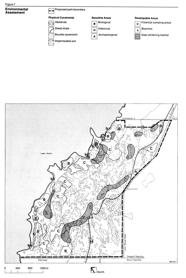
Two low sand dune areas behind and northeast of the main beach have been designated as sensitive areas, because they contain a variety of dry-land plants generally associated with Lake Huron. These dunes, plus a small marshy depression on the lake side of the northeastern area, can be used to great effect in an interpretive program to relate MacGregor Point to the ecology of the Bruce Peninsula.
Deer-yarding and wintering areas, identified by cover-type, are designated in Figure 7. Deer yards should not be subjected to excessive clearing. Snowmobiling and other winter recreation activities which could disturb the deer should not be allowed in the yarding areas which will be maintained by an active management program.
Archaeology
The one archaeological site discovered on the park property has been disturbed by repeated ploughing. The extent of the site is not known; consequently, any earth removal in this area should be avoided. The possibility of the existence of additional sites along raised beaches makes it desirable to monitor construction excavation where this activity coincides with the ancient shores.
History
The most important historical feature of the park, the old shore road, should be retained in its present state. The south end, which is little disturbed from its early days, is ideal for interpretive programs related to land transportation. Additional fragile features of local significance include the Campbell millpond and old mill, which should be preserved. The foundations of an old farmstead in the south portion of the park and its associated orchard and lime kiln and an old fieldstone lime kiln located on the boundary between Lot 19 and Lot 20 are park specific features worthy of retention. It should also be recognized that the shipwrecks located off the shores of MacGregor Point have interpretive value.
Physiographic constraints
Water table
Because of the existence of a high water table, much of the MacGregor Point land base is swampy. Near Lake Huron, the swampy characteristic is the result of poor vertical and lateral drainage occasioned by the parent till material and the flat topography.
The wettest areas are generally troughs lying just above and parallel to the beach ridges. There are no extensive areas of better drained water-sorted sands and gravel soils either above or inland from the Algoma beach. One possible exception is the cleared field beside the old access to the park property above the Nipissing bluff. The limited area of sand and gravel soil interspersed with wet areas between the Algoma beach and the present shore constitutes the major potential development site (Figure 7). While drainage of these areas is possible, the underlying soil is generally too rich in marly clay to accommodate heavy use. Development should occur around these wet areas, leaving them as natural buffers between the camping areas. Most wet depressions dry up in the early summer, but some remain wet long enough to cause problems with mosquitoes. It may be necessary to drain a few areas, but only if they are not biologically important. The swamps and ponds inshore from Lake Huron are generally affected by the lake’s level. They are all biologically significant to the park and therefore should not be drained or treated with oil for mosquito control.
Stoniness
The underlying glacial till is stony. Over much of the property there is a surface scattering of boulders of different sizes (Figure 7). In certain areas, these boulders have been aggregated by storm action along former shorelines. The resulting boulder ridges impose a severe constraint upon development. Boulder pavement and ridges are most common above the Algoma beach. Slope Slope is a constraint along the Nipissing beach bluff, since construction of a road, for example, would require considerable embankment work. There are presently several breaks in the bluff, some of which have already been utilized for road placement.
The lesser beach ridges constitute minor obstructions requiring detailed topographic survey prior to their accommodation within final site development plans.
Unstable soils
These soils include clay soils found outside the wet areas and restricted to the general area above the Algoma beach (Figure 7).
Dry sands might also be classified as unstable soils. The small sand deposit areas lying behind the four small beaches on the property should be protected from excessive pedestrian activity. Because of the destruction of vegetation, there is already considerable wind erosion behind the beach in the township park and to a lesser degree in the cottage subdivision area.
Capabilities of developable areas
Campgrounds
The potential campgrounds for MacGregor Point are designated in (Figure 7). Campground density will vary from four sites per ha in Campground A to three sites per ha in Campground B to 2.5 sites per ha in Campground C. These low campsite densities, which will be replicated in campgrounds D and E, were selected to suit the somewhat variable to flat terrain of the camping areas. Such standards permit flexibility in campground design and should create a quality camping experience while minimizing damage to the environment, which might ensue where the campsites are more crowded. On the other hand, the average density for these campgrounds is not low enough to raise adversely the development costs per site.
Shoreline
Much of the shore is composed of gravel and cobbles and is durable relative to pedestrian use. Storm pebble shore beaches are generally unstable, if they are steep-sided, and the pebbles are well-rounded. Damage to the vegetation covering the pebbles is certain to occur. The stable surface of grassed over sands and gravels on the old shore road will unavoidably disappear with constant use. While the ability of the shoreline to withstand the pressures of various activities is difficult to assess, its biophysical capacity is probably equal or superior to that of the interior.
Land base
The overall capacity of the land base to facilitate recreational activities varies enormously from site to site. Ground capabilities vary between low and high areas from the present shore to the Algoma beach, while from this area to the Nipissing bluff, much of the land has a low overall capacity for trails or similar developments. The moderately dense cover of trees and underbrush is important for screening activities, especially because of the flat topography. Any extensive clearing of underbrush will lower the capacity for quiet, extensive recreational activities.
Park policy
Park philosophy
MacGregor Point Provincial Park, as one unit within an overall system of provincial parks, will assist in meeting the three objectives of the outdoor recreation program for the province. The emphasis of this park will be on the provision of a wide range of outdoor recreational opportunities ranging from camping and bicycling to snowmobiling and cross-county skiing. The physical constraints of this site, in combination with the local and regional significance of certain physical, biological and historical features, dictate that the allocation of activities and facilities of an extensive nature in order to ensure that the natural character of the park is retained. Because the prime recreational activity will focus on destination camping, park visitors will undoubtedly contribute to the local tourist economy at nearby Port Elgin and Southampton.
Park goal
MacGregor Point Provincial Park will provide a variety of quality, low intensity, year-round recreational experiences within a natural environment. The facilities created will be compatible with the physical, ecological and cultural attributes of the park and will complement the more intensive recreational opportunities already existing within the immediate market area.
Park objectives
- To provide, only on land of moderate to high use capability, recreational developments which will harmonize with the terrain and will not cause noticeable deterioration of the natural land base.
- To provide a variety of destination camping experiences, including single and double family sites and walk-in and group camping areas. Other activities, especially in the prime camping season, will orient themselves toward this central recreational theme.
- To retain the peaceful atmosphere of the park environment through the careful site planning of road placement and the encouragement of pedestrian circulation within the development zone. This will obviate the need for large parking facilities near the activity areas.
- To provide a visitor services program based on a strong central theme relating to the Huron Fringe physiographic and ecological features represented within the park.
- To preserve the continuity of the Lake Huron shoreline by prohibiting the development of parking lots, boat launches and campsites within the historic shore road corridor so that visitors can enjoy the shoreline features in peaceful, visually unobstructed surroundings.
- To minimize future maintenance and control problems through well designed park development. For example, the total number of campsites will be kept to a level which can be handled from a maximum of two campground offices.
- To provide opportunities for a variety of seasonally distinctive recreational activities, such as hunting and snowmobiling, which will be constructively programmed, managed and reviewed within the park.
Park classification
MacGregor Point Provincial Park will be classified as a recreation park in accordance with the criteria established by the Ontario Provincial Parks Classification System. Although the park’s size and capability for sustaining extensive, as opposed to intensive, recreational activities indicate that it might be considered a natural environment park, its lack of provincially significant ecological features, combined with the flexibility inherent in the recreation classification, has made MacGregor Point most suitable for this category.
Park zoning
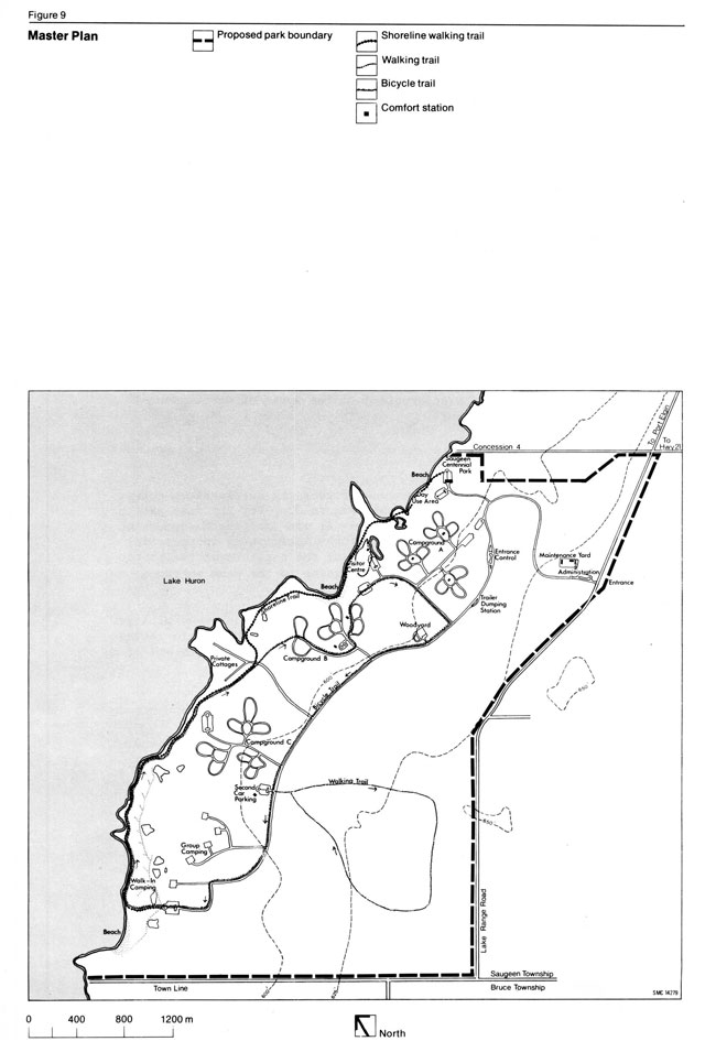
The zoning system, as set forth in the park classification system, is essential to ensure the orderly development and effective management of parklands. MacGregor Point has been divided into three zones designated according to the criteria of values for preservation, conservation and recreational uses (Figure 8).
Development zone
The development zone covers approximately half of the park area and includes the recreational core of the park, which will provide facilities for a wide range of day-use and camping activities. The extent of this zone relates to MacGregor Point’s classification as a recreation park. However, because the physical and biological conditions are generally constant throughout the park property, the greatest amount of development will occur within the sections of least conflict with such identified sensitive areas as the deer yards and the physiographic constraint areas, (i.e. wetlands or steep slopes). Consequently, a major recreation core, which was planned to fulfill MacGregor Point’s purpose of re-establishing the camping facilities removed from Inverhuron Provincial Park and also to provide for possible future expansion, will include a day-use area in the northwest corner of the park and five campgrounds oriented toward Lake Huron. Several hiking trails will penetrate the remainder of the development zone in order to provide free pedestrian flow to and from the camping areas, the visitor centre, the day-use area and the natural environment zones of the park.
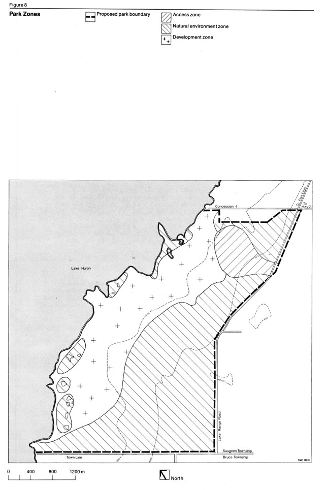
No commercial timber extraction will be allowed in this zone, and all necessary clearing operations will be restricted to trails, road right-of-ways, campsites and service areas, as specified in the site plans. However, as outlined in special management plans, small plots may be cleared in restricted areas to maintain the wildlife habitat. Some timber management may be allowed for demonstration purposes in conjunction with the visitor services program. Dead, injured or fallen trees will not be removed unless they threaten safety, mar the aesthetic setting, are located immediately adjacent to high use areas, or, in the latter case, if they also obstruct a trail or road.
All activities which might cause extensive environmental damage or which conflict with other activities will either be prohibited or will be programmed by visitor services staff in consultation with the park superintendent. Snowmobiles will be permitted to use some of the park roads and part of the bicycle trail subject to a control and education program. No all-terrain vehicles or off-road motorbikes will be allowed in the park. Hunting in the development zone will be in accordance with established guidelines.
Natural environment zone
The natural environment zone designation includes most of the eastern half of the park property, including several small areas situated along the shoreline.
Establishment of the major natural environment zone relates to the recognition of the ecological and cultural values of such features as deer yarding areas, the Lake Nipissing bluff and biological, historical and archaeological sites lying within the eastern section of the park. Only limited extensive recreational opportunities will be provided in this zone.
Management will be necessary to maintain existing habitats for wildlife and plant species. Although emphasis will be placed on maintaining existing species, habitats in some cases may be altered to encourage the establishment of native species, such as wood duck.
The several small natural environment designations will protect and preserve sensitive natural wetlands that contain a combination of locally unique, fragile plant communities and wildlife habitats. With the exception of walking trails, no development will occur in these small natural environment zones. Along the walking trail, where it is necessary to protect the fragile ground cover, boardwalks will be built for viewing purposes. The placement of trails will be designed to minimize detrimental impacts upon wildlife and significant plants. Activities related to fishing, trapping, collecting or other forms of resource extraction and the use of vehicles, including bicycles, will not be permitted.
Access zone
This zone was established to provide the minimum facilities required to support access to and/or through an area having the attributes consistent with a natural environment zone designation.
The access zone site was selected because it possesses marginally fewer physical and cultural restraints with respect to development and recreational use. In addition, the site permits easy access for visitors from the Lake Range Road to the day-use and camping areas of MacGregor Point.
Development program
Six concept plan alternatives were compiled for MacGregor Point Provincial Park (Appendix B). Only alternatives which included camping as the core activity in the park were considered, reflecting the Ministry’s commitment to replace the campgrounds removed from Inverhuron Provincial Park.
Following discussion of the recommendations from the public meeting held to review the alternative concepts for the park and following contact with the Saugeen Township Council, Concept 4 was selected as the desirable concept on which to base future park development. This concept was refined and became the basis for the park master plan.
The following is a description of the types of development to occur in MacGregor Point:
Access
The park entrance will be located near the northeastern corner of the park on the Lake Range Road (Figure 9). For the most part, park traffic will proceed from Highway 21 via the fourth concession road of Saugeen Township. Because of the anticipated increase in the volume of traffic along these roads, the sections of the fourth concession road and Lake Range Road leading to the park entrance have been improved and paved (Appendix C).
A separate access road leading from the main park road will be developed for the cottage subdivision. Access to the single cottage near the walk-in camping area will be through a locked gate and along the walk-in camping route and service road.
Internal road circulation
The main park road will extend from the park entrance, westward to the entrance control booth, then southward through the park to terminate at the parking area designated for walk-in and group camping (Figure 9). Secondary park roads will provide access from the main road to the day-use area, Campgrounds A, B and C and the visitor centre. These roads will be paved. Tertiary roads, used for group camping access and cottage access, and possibly some camping areas will be paved where feasible. Additional roads will be built as determined by site plans, but no roads will be constructed within 90 m of the shoreline.
Parking areas
Parking areas will be separated from the visitor use sections of the park. Second car parking lots for campers will be located in each of campgrounds A, B and C and in the walk-in Campground. Parking lots in the day-use area (approximately 50 vehicle spaces)will be located at least 90 m from the shore to ensure the preservation of this area. A small visitor parking lot will be situated close to the campground control office. All sites will be appropriately landscaped. Pedestrian flow from the main parking centres will be channeled along durable paths to other sections of the park property.
Camping areas
The campgrounds at MacGregor Point will consist of group camping areas, walk-in sites and single and double family campsites. Campgrounds A, B and C, located south of the day-use area between the shoreline and the main park road, will contain approximately 400 campsites, comfort stations, second car parking areas and a children’s playground. In general, the campsites will be buffered from each other to ensure privacy. Campground A will consist of special large sites for house trailers and camper-backs, plus 50 sites with electrical outlets, as this area will be used for winter camping. These sites will be located in the southern part of Campground A to enable easier winter access and to reduce conflict with deeryarding areas farther north and south. The other two campgrounds will be designed to accommodate small equipment, such as tents and tent trailers. Campground B will contain specially designed pedestrian routes which will direct visitors around the sensitive sand dunes lying behind the beach. If paths must proceed through these areas to the visitor centre, they should be reinforced with paving stones or stone chips. In Campground C, trail design will be oriented toward respecting the privacy of the cottage subdivision. It is recommended that this campground also contain a small parking area for campers wishing to launch canoes.
The walk-in campground, having a maximum of 30 sites, will be operated on a pre-registration basis. The sites will be located within 30 m of the shore and, where possible, will be screened from the old shore road. A service road with a locked gate will be provided for maintenance purposes. The group camping area will accommodate about 200 people on four sites. The anticipated clientele will be Boy Scouts, Girl Guides and other special organization groups. The walk-in and group camping areas will be provided with vault toilets and a tap water supply.
Day-use areas
The day-use area of the park, combined with Saugeen Township’s Centennial Park, will offer a complete free day-use facility for approximately 440 users. Management of this area will be governed by the agreement outlined in Appendix C.
Two 50-unit car parking lots will service this area. Access to the beach and various hiking trails and bicycle paths emanating from the parking lots will provide day-users with free non-vehicular arteries to the rest of the park and its visitor services program. Other facilities in the day-use area will include picnic tables, fireplace grills, garbage cans and possibly an adventure playground, constructed of natural material.
It has been recommended that a picnic shelter be located in the day-use area for use during inclement weather and to provide a focal point for certain organized activities. The design of the shelter may permit enclosure for winter use.
Permit control structures
The main control and campground office will be located at the entrance to the campgrounds. It will comply with pre-registration needs and will be used for distributing campsite permits and park information to visitors.
Visitor centre
The visitor centre will be constructed near the lake between Campground A and Campground B, where it will be accessible to both campers and day-users. It will contain a staff workroom with storage and library facilities, washroom facilities, an exhibit room and an indoor theatre.
Signage
The signs used within the park will correspond to the standard form used in the provincial parks system. They will be used to orient park visitors, to inform them of public safety measures and to assist in visitor services programs. The number of signs will be kept to a minimum.
Washrooms
Three comfort stations, each with a laundry and shower, will be constructed in Campground A. Two similar stations will be located in campground B and one in Camping area C. The walk-in and group campgrounds and the day-use area will be developed with vault toilet facilities. In addition, vault toilets will be located throughout the other campgrounds and near the beaches. A former Saugeen Township building will be renovated to provide washroom and change house facilities at the day-use area.
Woodyard
The woodyard is located between Campground A and Campground B, having parking facilities for a limited number of cars and a turning circle to minimize traffic congestion. To discourage the removal of excessive quantities of fuelwood, the woodyard has been designed so that campers must carry their firewood approximately 30 m to their vehicles. A separate service entrance has been provided off the traffic turning circle.
Trails
Within the development zone, a system of trails will be developed to promote non-vehicular visitor circulation throughout the park. This system will consist of a variety of linear recreation routes, including a bicycle trail and nature and hiking trails. Many of these will double as winter activity trails, accommodating snowmobiling, snowshoeing and cross-country skiing (Figure 9).
The 3,000-m bicycle trail will utilize a major part of the main internal park road and a southern section of the old shoreline road. A complete loop will be formed by directing the path through part of Campground B to link with the main park road again between the woodyard and trailer dumping station.
The park’s walking trails will contain two main elements, the shoreline walking trail and a series of looped walking trails winding through (a) a major section of the western natural environment zone and (b) a cross-section of the shorelines east of the access road.
Most of the old shore road will be used for hiking. It will be maintained to resemble the current appearance of the road in the south part of the park, since this section is reminiscent of the typical appearance of the entire road during the latter decades of the 19th century. Footpaths will connect this trail to the day-use area and the campgrounds. Barriers will be used on the main trail to prevent the use of motorized vehicles; however, the barriers will be removed during the winter to permit snowmobilers the use of parts of the trail.
The walking trail within the natural environment zone will be used as both a self-guided trail and a trail on which interpretive hikes will be conducted periodically. Site planning will determine the precise location and design of the loop trail by considering in order of priority the protection of the natural features in the zone, the educational value of the walk and the recreational value of the trail. Boardwalks will be necessary along parts of the trail.
Architectural theme
The overall approach to building construction in MacGregor Point Provincial Park will be to blend each structure harmoniously into the landscape. This will be achieved through careful site design, location of buildings and sensitivity in the choice of building materials. Construction design will remain consistent throughout the park.
Park administration building
A centralized service area, composed of maintenance and administration facilities, will be located to permit easy access from this area into the public-use areas of the park and to the park entrance. The administration building will contain offices for the superintendent, the assistant superintendent, the visitor services programmer, the park enforcement officer and a clerk. Other necessary facilities will include space for a first-aid room, a drafting and map storage room, washrooms, a staff coffee room and a public reception lobby. The heated maintenance building will include the foreman’s office, a lunch room, washrooms, three work area service bays, a painting room and a vehicle maintenance area. A second maintenance shed will serve as storage for vehicles, equipment and supplies. The site design of the centralized service area and main campground control office will be such that these facilities will be within easy walking distance of one another to minimize staff vehicle movement within the park. Restricted road access in this area will also help to lessen traffic congestion and aid in achieving the park objective of restricting and controlling all motor travel.
Park design capacity
As visitors will almost assuredly travel by personal vehicle to the day-use area and the campgrounds of MacGregor Point, the number of parking spaces in the day-use area and the number and type of campsites in the park determine the upper maximum total number of users that can enjoy the park at any one time.
Consequently, with approximately 90 parking spaces planned for the combined Saugeen Township and MacGregor Point day-use area, plus a total of fewer than 450 family, walk-in and group campsites, the total number of visitors that the park could accommodate instantaneously during a typical summer day would be a maximum of 3,500 people.
If the results of monitoring programs do not record signs of excessive use, then additional parking facilities could be provided up to the maximum outlined for certain visitor and second car parking lots. However, the park should not be allowed to become congested, nor should environmental degradation resulting from overuse of the site be tolerated.
Implementation phasing
Development of the park will be phased to provide for the establishment of functional units within the development zone. Actual site development began in September 1974 and will continue over a period of several years until park development is completed. Phase I is nearing completion. Phase II should be completed prior to 1983. Site plans have been prepared for the development of facilities as part of the implementation of the master plan.
Phase I
- Access: The main road has been constructed with a gravel surface from the park entrance to the day-use area and as far as Campground C.
- Central Service Area: The administration, maintenance and campground control office facilities have been completed.
- Day-use Area: The site has been made operational with picnic tables, parking and washroom and change house facilities. The trails have been cut out.
- Campground A and Associated Parking Area: The site has been made operational with all service facilities, including barbecue grates, picnic tables, comfort stations, roads, sewage, water and primary electrical conducts.
- Visitor Centre and Parking Lots: This complex has been completed. Two parking lots for a total of 100 cars, vault toilets, and trails around the lots and to the beach area have been constructed.
- Campground B and Campground C: Development of campsites, roads and most services will be completed.
- Cottage Access Road: To be complete from main park road to cottage subdivision.
- Trailer Dumping Station: This site has been made operational with a septic tank and waterline.
- Comfort Station: A comfort station has been located in the day-use area.
- Park Services: The electrical system has been completed for Campground A. The central water system has been constructed and all lines laid in Campground A. The sewage system for Campground A is operational. Telephones have been installed and all cables laid.
- Signage: Orientation information will be located throughout the park.
Phase II
- Access: The main road will be paved and landscaped.
- Woodyard: The site will be fenced and landscaped.
- Campgrounds: B and C camping areas, the group campground and the walk-in sites will be completed with full service facilities.
- Visitor Centre: This complex will be made operational.
- Comfort Stations: Two Type 9 stations and one Type 4 station with laundry and shower facilities will be constructed in Campground B and Campground C, respectively.
- Park Services: Electrical outlets will be installed in 50 Campground A sites. Water and sewage facilities will be completely installed.
- Playground: A playground will be constructed between the beach and the visitor centre.
- Trails: A 4.8 km to 6.4 km bike path and short walking trail will be completed in the southeastern part of the property. Two paths will be cleared and will lead out from the visitor centre.
- Picnic Shelter: A picnic shelter will be constructed when demand for this facility necessitates such action.
- Tree Planting: A five-year program will be initiated for aesthetic and wildlife management purposes, especially in the heavily used area.
- Signage: Interpretive material and displays will be placed throughout the park.
| Area | Cost |
|---|---|
| Phase I | $1,960,000.00 |
| Phase II | 1,730,000.00 |
| Equipment | 56,000.00 |
| Total | $3,756,000.00 |
Site plans
Required plans will be designed and formulated by the Site Planning Section in consultation with field staff, to direct the construction of campsites, parking lots, service buildings, play areas, roads and trails within the park.
Tree planting program
A tree planting program, which will be drawn up as part of the site plans, will begin as soon as possible in order to break up large open areas and to cover roads which will no longer be used. In conjunction with the wildlife management program, a variety of species native to the area will be used. Following park development:, tree planting will continue in the heavy use areas such as the campgrounds and day-use areas. Trees which die as a result of age or trampling will be replaced.
Park operations
Staffing
This section of the master plan will provide an outline of the staff requirements and organization, necessary for the operation of the park (Figure 10). The park superintendent, upon whom the overall operation and management of the park depends, will be experienced and qualified in numerous fields, ranging from the natural and cultural history of the MacGregor Point area to staff management and maintenance work. Other complement staff required to operate the park on a year-round basis will include an assistant park superintendent, a n intenance foreman, a clerk and a visitor services programmer, who will plan, implement and co-ordinate the visitor services program. The MacGregor Point office, in addition to operating the park, will be responsible for managing the Inverhuron day-use area plus other adjacent Crown lands, such as the Denny’s Darn area on the Saugeen River. Aside from these five full-time staff members, a conservation officer assigned to park enforcement duties, will be available during the main camping season (mid-May to mid-September) to provide information to park users and to ensure the protection of park facilities and resources. A seasonal staff consisting of approximately 20 maintenance, gate, beach patrol, night patrol, office and visitor services personnel will initially be required during the summer months.
Park services
Water
A central water system for the park will be constructed on a large headland, which juts out into Lake Huron just north of MacGregor Point itself. From this pumphouse which contains a 4,322.5 litre chlorine contact tank, the water is pumped to a secondary station with a 113,750 litre reservoir in Campground B.
From this point, it is distributed to other points in the park. This method of pumping water from the lake was necessary, because three wells drilled during the development of Campground A contained water which, when tested by the Ministry of the Environment, was found to be unacceptable for human use.
Sanitary facilities
To service Campground A, a large remote tile bed, containing four small beds, was constructed approximately 610 m from the camping area. Depending on the ground conditions, tile beds will also be used for Campground B and Campground C. In this case, they will be located right at the comfort station. This sanitary system, if feasible, is preferable to a sewage lagoon mainly for cost reasons.
Figure 10: Staff organization
- Park Superintendent
- Assistant Park Superintendent
- Inverhuron Seasonal Staff
- Clerk
- Seasonal Office Staff
- Foreman
- Seasonal Maintenance Staff
- Visitor Services Programmer
- Seasonal Visitor Services Staff
- Park Enforcement Officer
- Seasonal Beach Patrol and Night Patrol
- Assistant Park Superintendent
Download printer-friendly organization chart (JPG)
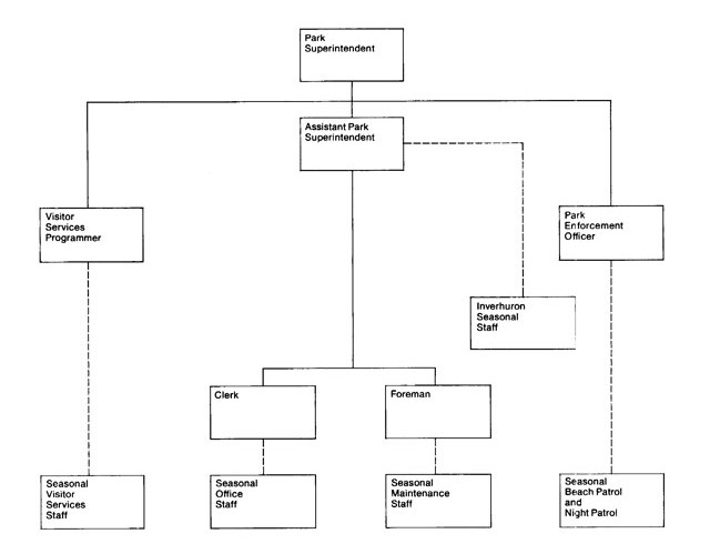
Hydro
Wherever possible, power lines in the park will be located underground. Lines which must be constructed above the ground will not have cleared rights-of-way. The hydro for Campground A has been laid completely underground. Electricity will not be required beyond the cottage area, as the facilities in Campgrounds C, D and E need not be illuminated. The existing overhead line along the shore will be removed once new lines have been laid to the cottage subdivision.
Telephone
Telephone cables, also buried underground, have been installed in the central service area to allow incoming and outgoing calls to and from all major park offices as well as internal calls between the maintenance, administration and main control office areas. A public phone booth has been provided at the Campground control office.
Fire protection
MacGregor Point is serviced by the Saugeen Township fire department, which is located approximately 3 km northeast of the park entrance. Agreements will be negotiated between the Township and the Ministry of Natural Resources for fire protection within the park.
Emergency services
All reasonable precautions will be taken to ensure the safety of park visitors. An emergency services plan will be put into operation, including a communications network, a park first-aid station and police, fire and ambulance service to the park.
The park will provide its own policing service, supplemented by the O.P.P. detachment located in Walkerton. Ambulance service is available at Southampton, and Port Elgin is the location of a coastguard rescue unit.
Visitor services
This section outlines the scope and intent of the visitor services program for MacGregor Point Provincial Park and acts as a guideline for the future compilation of a comprehensive visitor services program plan.
Program outline
The park area is an important link in the Huron Fringe physiographic unit connecting the developed agricultural and industrial south with the frontier and tourism-oriented north. Visitors will be informed about the area of influence stretching roughly from Goderich in the south to the Sauble-Rankin area on the Bruce Peninsula in the north. The physiographic, ecological and historical elements which have affected settlement and transportation patterns along this segment of Lake Huron constitute the basis of the park theme.
Programming will focus on providing a high quality, low intensity recreational experience in a natural environment. Facilities will be compatible with the physical and cultural attributes of the park and will complement the more intensive recreational experiences already available in the immediate area.
The park will operate a major activity program based on provincial visitor services policy. Although the major programming emphasis will occur from May to September, a visitor services programmer will be available on a year-round basis to accommodate a wide range of user groups and to provide programs reflecting seasonal activities, such as spring fishing, fall hunting and winter recreation. Use of the visitor centre will be encouraged during all seasons. School groups will utilize this facility primarily in the fall, winter and spring seasons. The centre may also be used as a focus for the completion of park-related research projects in the winter months.
MacGregor Point will serve as a nodal park within the context of other surrounding Ministry-operated facilities. The visitor program at MacGregor will provide occasional technical expertise, training, equipment and staff Point Farms Provincial Park, Sauble Falls Provincial Park and Denny’s Dam.
The role of communication, recreation, interpretation and outdoor education within the park will be as follows:
Communication
In order to orient visitors to the park’s operations, regulations, facilities, programs and points of interest in the local areas, a wide variety of publications, audio-visual productions and signage will be utilized at various levels of detail. General park information should be available at the administration office and campgrounds, and more specific information will be available from the visitor centre. All park employees will place strong emphasis on personal contact and communication.
Publications distributed will include park brochures, individual campground guides, newsletters, resource reports relating to the park theme, management messages, recreational and educational brochures, natural history checklists, other relevant Ministry literature and local interest information.
The park theme is graphically portrayed in the park logo (Figure 11). The background of the design is the interface of land and water comprising the Huron Fringe. The parallel waves represent the post-glacial Nipissing and Algoma shorelines as well as the old shoreline road, which winds its way through the park. The sail represents historical navigation as well as contemporary recreational boating, while the cart depicts pioneer travel, and its wheel suggests bicycling.
Recreation
In accordance with the park’s recreational classification, the visitor services program will emphasize low intensity recreational opportunities, consistent with the natural environment and the park theme. Intensive and/or urban-oriented activities found in the local area will be considered inappropriate.
Emphasis will be placed on the provision of self-use facilities that help visitors to explore the park. The old shoreline road will accommodate varied trail activities, including bicycling, jogging and snowmobiling, and can be used by those wishing to visit some of the park’s biological, physical or historical features. The shoreline are as will also be used for swimming, canoeing and fishing, and an adventure playground located behind the beach in the day-use area will provide challenging play opportunities in a natural setting. Other facilities will include a visitor centre, walking trails, a bicycle trail, a cross-country ski trail, photography blinds and a campfire area.
Staff-organized programs will include resource-oriented recreational programs, such as walks, campfire cooking, crafts, bicycle hikes and photography and painting sessions. A fully integrated recreational skills program, emphasizing the resource nature of the area, will be encouraged. Particular emphasis should be placed on programs promoting the use of various field guides for identification purposes and for nature viewing and photography.
Figure 11: Park logo

Recreational activities which would be considered appropriate are listed below:
- Angling
- Archery
- Boating
- Camping
- Children’s Program
- Cycling
- Day camping
- Handicraft instruction
- Hiking
- Historical appreciation
- Hunting - deer waterfowl
- Interpretation
- Kite flying
- Nature study
- Orienteering
- Painting
- Performing arts
- Photography
- Picnicking
- Playground activities
- Recreational driving
- Sailing
- Scientific study
- Scuba diving
- Skating
- Skin diving
- Cross-country skiing
- Snowmobiling
- Snowshoeing
- Swimming
- Tobogganing
- Wildlife viewing
The intent of the interpretive program is to arouse the visitor’s interest in the natural and cultural values of the park, to encourage individual exploration of all aspects of the park and to interpret the park’s goal and objectives, thus creating a background against which specific management decisions and special regulations can be articulated.
The park contains a fine representative sample of Huron Fringe physiographic features (Chapman and Putman, 1966) which have influenced the natural and historical developments in the park and surrounding areas; hence the derivation of an interpretive program theme incorporating several subject areas which relate to the park’s geology and history.
Much of the interpretation within MacGregor Point will be accommodated through self-use facilities. The visitor centre will serve as the focal point for the distribution of interpretive media and park information. It will contain exhibits, displays, an indoor theatre and a library for reference material relating to the park and regional resources. During the summer months, the centre will accommodate such activities as children’s programs, workshops, handicraft instruction and photography sessions. During the school year, the centre will be utilized by school groups and will be available as a service centre for winter recreation enthusiasts.
Other self-use interpretive facilities include wayside story boards on certain trails, exhibits and publications. Such publications as A Children’s Guide to the Birds, Looking at Reptiles and Amphibians and A Different Look at Hunting could be prepared.
Because of the significance of the resource base and the fact that as a provincial park, MacGregor Point offers the best representation of the Huron ringe in the province, some interpretive programming is essential. Programs should retain the recreational flavour of the park, but could include historical and archaeological explorations, physical geography programs and nature appreciation.
Outdoor education
The use of MacGregor Point for educational opportunities of a day-trip nature will be encouraged because of the resource base, available facilities and the high potential student user population in the area. All educational activities and instruction will be the responsibility of the local school boards, although park staff will be prepared to outline background information, points of interest, topics for further study and park regulations to teachers wishing to tour school groups through the park.
Extra outdoor education programs will be conducted to assist special user groups to utilize the park wisely and to full advantage, while minimizing potential conflict with other park visitors. For example, programs might focus on hunting clubs and snowmobile clubs to provide personal contact and outline park regulations.
Visitor services staff
Visitor services at the park will be co-ordinated by a yearround visitor services programmer who will work under the direction of the park superintendent. The programmer should have a strong interpretive and recreational background. Seasonal programmers will be required to provide additional services to park visitors. In order to fulfill its nodal visitor services function, the park’s staff will be responsible for providing a limited amount of assistance to surrounding satellite programs.
Research and planning
Monitoring of users and environment
An ongoing ecological assessment of the impact of various recreational activities on the environment will be carried out within MaeGregor Point. A detailed plan will outline a number of sample plots which will be established in the heavy-use areas, such as the campgrounds and beaches, before and during park development.
Information pertaining to the density and age structure of the tree cover and understory, species composition and depth of litter and humus in the soil profile will be recorded. The plots will then be re-examined at one - to five-year intervals to assess the impact of park use on the biota and soil in order to make appropriate adjustments, if necessary, to the plan, park operation and management of MacGregor Point. Data obtained will be analysed during the required periodic review of this master plan.
Resource management plans
Resource management programs ensure that all ecological cultural and physical aspects of the park which are significant or highly sensitive environments are not disturbed or destroyed. Within MacGregor Point, resource management techniques will be outlined for such areas as the Nipissing bluff, the inland ponds and the deer yarding areas. Ongoing research into visitor capacities for MacGregor Point will undoubtedly lead to management techniques in the future. All resource management plans are drawn up in conjunction with the visitor services program plan.
Visitor services program plan
This plan defines the program which will enable park visitors to enjoy the natural and cultural features and other attributes of the environment at MacGregor Point. The visitor services program plan, will define a specific level of communication, interpretation, outdoor recreation and outdoor educational services to be offered at MacGregor Point following the direction outlined in the visitor services section of this master plan.
Wildlife management policies
Wildlife management at MacGregor Point will be directed towards maintaining wildlife populations for uses such as education, viewing and photography. All of the wildlife management programs, which will be in harmony with the philosophy of the park goal, will be articulated within a management plan setting out the goal, objectives and management techniques for MacGregor Point. It will relate directly to the visitor services program plan for the park and will be reviewed annually.
As a result of the local historical precedence and the recreational significance of hunting as a pastime, certain forms of hunting will be allowed. White-tailed deer hunting will be permitted in season according to provincial regulations. Hunting for migratory waterfowl will be permitted in season along the shore of Lake Huron, but not on the inland ponds. While waterfowl hunting will be allowed all day on Saturdays, it will be restricted to the hours between dawn and 9 a.m. and between 4 p.m. and dusk on weekdays. Hunting of upland game and trapping of fur-bearing animals will not be permitted. According to directives prepared by the park superintendent, these regulations will be reviewed periodically by park, district and regional fish and wildlife personnel.
Deer management will involve maintaining a healthy herd at the existing population of 15 to 25 deer per sq. km. To fulfill this objective, existing clearings will be maintained and supplemented by additional small plots around the deer wintering areas; as directed by the park superintendent, limited controlled burning will be permitted as a management tool and possibly for interpretive purposes; snowmobile trails will not pass through deeryarding areas.
Upland game management for ruffed grouse, snowshoe hare and other species will include maintaining optimal populations by habitat manipulation for viewing purposes and interpretive programs only.
No hunting or trapping of upland game species for population control will be allowed. The management techniques practised for white-tailed deer will generally also benefit upland species. Male aspen may be selectively maintained in some areas to improve the ruffed grouse habitat, while the limited clearing of dogwood in the southeastern corner of the park will aid the woodcock habitat. Waterfowl management will involve encouraging nesting on some of the inland ponds by placing woodduck boxes in favourable locations, planting native species of trees, shrubs and herbs for waterfowl habitat and constructing nesting islands and clearing narrow forest indentations for browse and nesting areas.
Appendix A: Public participation program
The public participation program used to aid in the formulation of the MacGregor Point Provincial Park Master Plan involved a public meeting which was held in the spring of 1974 at Port Elgin High School. This open session, which was advertized through the media, was attended by approximately 400 people, including representatives from the Southampton and Port Elgin town councils and the Saugeen Township council. The viewpoints and recommendations presented by several interested groups were documented by the Ministry of Natural Resources planning team. As a result of these public submissions, changes were made in the preliminary master plan.
The Ministry planning team also held several separate meetings with the Saugeen Township council to introduce concepts for the park to the members and to discuss agreements regarding the location of the park entrance, the use of Centennial public beach lying adjacent to the northwest corner of the property and the replacement of electrical facilities. Other meetings were held between Ministry staff and the MacGregor Point Cottagers Association regarding agreements for a new access road into their subdivision, the installation of service facilities and other matters that caused concern among the cottagers. These meetings were necessary to ensure that the local residents were informed and satisfied concerning the plans for the park and to facilitate development of MacGregor Point Provincial Park as quickly as possible. Rapid development became necessary because of the safety factors associated with the closing down of camping facilities at Inverhuron by 1975 and the role that MacGregor Point was to play as a replacement park.
Appendix B: Concept plan alternatives
The preparation of concept plan alternatives involves the identification and evaluation of a variety of optional courses of action for the preservation, development and management of the park. Six alternatives were formulated all within the bounds established by the environmental impact assessment, except in one case. The sixth alternative, by locating the day-use area at the south end of the park, would destroy both the historical aspects of the shore road and the natural value of the wetlands lying just back from the shoreline. Although the first alternative formulated does not allow full replacement of the campsites lost at Inverhuron, this was not considered an absolutely essential criterion for development of the new park. An evaluation process was used to compare all alternatives; each alternative was ranked according to the degree to which it satisfied numerous criteria considered desirable for the park.
In general, the six alternatives, as itemized below, indicate variations only in the extent of their development. Each alternative provided for such facilities as group camping, a visitor centre and a system of walking trails.
- Alternative 1 would provide for 288 campsites in two campgrounds and a day-use area at the north beach adjacent to Centennial Park. The main development would be concentrated near the north end of the park, leaving the remainder of the property for extensive activity use, such as hiking or bicycling.
- Alternative 2 would provide for 366 campsites in three camping areas and a day-use area in the north end of the park. One of these campgrounds would provide 78 walk-in sites at an average density of about 4 per ha.
- Alternative 3 would provide for 315 sites, including 27 walk-in sites at the south end of the park. The day-use area would be located at the north end of the property.
- Alternative 4 would provide for 393 sites, including 288 standard car-camping units, 78 low intensity tenting sites and 27 walk-in sites. Day-use would be at the north beach.
- Alternative 5 would provide for 535 sites, including two campgrounds for standard trailer/tent sites and two areas for tents only. Day-use would be at the north beach.
- Alternative 6 would provide for 405 sites and a park entrance and day-use area at the south end of the park.
Concept 4 was selected as the desirable concept on which to base future park development.
Appendix C: Agreements
The Ministry of Natural Resources will make legal agreements with the following authorities and organizations pertinent to the establishment and development of MacGregor Point Provincial Park:
- Ontario Hydro: Ontario Hydro agreed to purchase Inverhuron Provincial Park when the Atomic Energy Control Board issued a directive, to phase out camping at the park for safety reasons. As owners, Ontario Hydro signed an agreement which prohibits the building of any hydro facilities at Inverhuron or the changing of any of the park’s wilderness characteristics or historical, archaeological or biological features. The Ministry of Natural Resources will, in turn, continue to operate the Inverhuron beach and picnic areas on a day-use basis, free of charge to the public. The second part of the negotiation involved Ontario Hydro’s payment for the establishment of MacGregor Point Provincial Park.
- Saugeen Township: This management agreement will allow the Ministry to manage the entire 122 m of sand beach frontage in Centennial Park to provide a combined free day-use area to the public, with access from MacGregor Point Provincial Park. Centennial Park was donated to Saugeen Township by the local chapter of the Women’s Institute. The area will remain under Township ownership with the Ministry assuming all maintenance, operational and policing responsibilities. The Township has been requested to close the Fourth Concession Road access to this beach to control future free day-use from within the park. In addition, the Township has been requested to release to the Ministry the 20-m road allowance which parallels the entire shoreline of the MacGregor Point Provincial Park property.
- MacGregor Cottage Owners Association: This agreement will be negotiated in order to alleviate park user and cottage owner conflict apparent in several other existing provincial parks. The association consented to give up their former right of access in return for a newly constructed and separate entrance to their cottage subdivision from the main park road. The Ministry accepted all of the costs of road construction and the replacement and installation of utility services, including hydro and telephone lines. The Ministry also agreed to provide the cottagers with free garbage pick-up and snow clearance during the winter. The park design will provide for a substantial buffer between the cottage subdivision arid general park development.
- Saugeen Township and Ministry of Transportation and Communications: Saugeen Township had expressed concern about the increase in traffic on Township roads adjacent to the park. Consequently, an agreement was reached whereby the Ministry of Natural Resources and the Ministry of Transportation and Communications would share the costs of upgrading and paving sections of the Fourth Concession Road and the Lake Range Road between Highway 21 and the park entrance. Further negotiations with the Township included the relocation of the park entrance from the Fourth Concession Road to the east side of the park along the Lake Range Road. This agreement was made in order to direct traffic away from a seasonal residential area and to avoid access control problems to Centennial Park.
References
Brown, D., G.A. McKay and L.J. Chapman. The Climate of Southern Ontario, Federal Department of Transport, Meteorological Branch, 1968.
Chapman, L.J. and D.F. Putman. The Physiography of Southern Ontario (2nd ed.), University of Toronto Press, Toronto, 1966.
Cuddy, D.C. Ecological Inventory of MacGregor Point, Bruce County, Ontario. Ontario Ministry of Natural Resources, Park Planning Branch, Environmental Planning Section, Toronto, 1973.
M.M. Dillon Ltd., Consulting Engineers and Planners, Official Plan, Bruce County South Planning Area, Draft No. 1, January 1975.
Environment Canada, Monthly Record: Meteorological Observations in Canada, 1961-1974.
Greenland, G. Brief Historical Inventory of MacGregor Point, Saugeen Township, Bruce County. Ontario Ministry of Natural Resources, Park Planning Branch, Environmental Planning Section, Toronto, 1973.
Hoffman, D.W. and N.R. Richards. Soil Survey of Bruce County. Ontario Soil Survey Report No. 16, Canadian Department of Agriculture and Ontario Agricultural College, 1954.
Ontario Ministry of Natural Resources, Ontario Provincial Parks Statistical Reports. 1971-1977.
Ontario Ministry of Natural Resources. MacGregor Point Provincial Park Preliminary Master Plan, Park Planning Branch, Toronto, 1974.
Rowe, J.S. Forest Regions of Canada. Department of Environment, Canadian Forestry Service publication No. 1300, Ottawa, 1972.
Thomas, S. and R. Zurba. The Initial MacGregor Point Archaeological Survey Project. Ontario Ministry of Natural Resources, Toronto, 1973.
Vrancart, R. and D. Simkin. Towards an Outdoor Recreation Policy for Ontario: Phase I. Ontario Ministry of Natural Resources, Toronto, 1970.
Warren, W. Geology and Geomorphology of the MacGregor Point Proposed Park Area, Saugeen Township, Bruce County. Ontario Ministry of Natural Resources, Environmental Planning Section, Toronto, 1973.