Marten River Provincial Park Management Plan
This document provides policy direction for the protection, development and management of Marten River Provincial Park and its resources.
© 2001 Queen’s Printer for Ontario
51244
(0.2k, 01 03 31)
ISBN 0-7778-8129-2
Cette publication est egalement disponible en francais.
Approval statement
I am pleased to approve this Management Plan for Marten River Provincial Park. It is a statement of policy for the protection, management and development of park resources. It also provides guidance for the preparation of plans for resource management, natural heritage education and development to implement park policies and achieve park objectives.
Adair Ireland-Smith
Managing Director
Ontario Parks
Statement of environmental values under the environmental bill of rights
The Ministry of Natural Resources' Statement of Environmental Values (SEV) was prepared in accordance with the provisions of the Environmental Bill of Rights (EBR). It describes how the purposes of the EBR are to be considered whenever decisions are made which might significantly affect the environment.
The primary purpose of the EBR is to protect, conserve and, where reasonable, restore the integrity of the environment. From the MNR's perspective, that broad statement of purpose translates into four objectives in its SEV:
- to ensure the long-term health of ecosystems by protecting and conserving our valuable soil, aquatic resources, forest and wildlife resources as well as their biological foundations;
- to ensure the continuing availability of natural resources for the long-term benefit of the people of Ontario;
- to protect natural heritage and biological features of provincial significance; and
- to protect human life, the resource base and physical property from the threats of forest fires, floods and erosion.
The Ministry’s SEV has been considered throughout the preparation of the Management Plan. The Management Plan for Marten River Provincial Park will further the objectives of managing Ontario’s resources on an ecologically sustainable basis.
1.0 Introduction
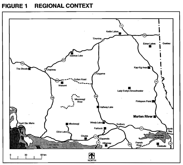
Marten River Provincial Park is located 56 kilometres north of North Bay (Figure 1). It encompasses 400.249 hectares of land which includes waters and shoreline of the Marten River. Situated between Highway 11 and Highway 64, the park provides camping and day use opportunities to destination travellers and to tourists travelling along the highways.
The park is located in a zone of transition between the Great lakesSt. Lawrence Forest of southern and centralOntario and the boreal forest of the north. The result is a diverse forest community exhibiting characteristics of both forest regions.
Marten River Provincial Park was taken over from the Department of Highways by the Department of Lands and Forests in 1956 to serve as a recreational park area. It was placed into regulation in 1960 (Ont. Regulation 204/60) until superseded by Ont. Regulation 154 in 1983.
The Marten River Provincial Park Management Plan outlines the management direction for the park and its development for the future, including the upgrading of its facilities and new marketing strategies.
2.0 Classification
Marten River Provincial Park is classified as a recreation park under the provincial park classification system. Recreation parks are areas which support a wide variety of outdoor recreation opportunities for large numbers of people in attractive surroundings.
Marten River Provincial Park provides a number of attractive campsites concentrated along the Marten River shoreline. These campsites provide access to sand beaches and the Marten River for boating and angling. The park’s existing recreation opportunities contribute to the achievement of the recreation targets outlined in the North Bay District Land Use Guidelines (1983) and to the provincial parks system objectives.
3.0 Goal
The goal of Marten River Provincial Park is:
To preserve the park’s environment and provide a variety of outdoor recreation opportunities for both destination and short stay visitors while protecting the park from the impact of human activity.
4.0 Objectives
As a recreation class park, Marten River Provincial Park contributes to the achievement of the protection, recreation, heritage appreciation, and tourism objectives of the provincial park system.
4.1 Protection
To protect the natural, recreational and cultural values of the park.
Marten River Provincial Park occurs in the Great Lakes-St. Lawrence Lowlands Forest Region. The park contains both upland and lowland plant communities along the Marten River.
Marten River Provincial Park’s forest communities consist primarily of red pine (Pinus resinosa) and white pine (Pinus strobus). Stands of white birch (Betula papyrifera) and poplar (Populus L.) are present and other common tree species include white spruce (Picea glauca) and black spruce (Picea mariana), eastern white cedar (Thuja occidentalis), sugar maple (Acer saccharum) and balsam fir (Abies balsamea). The park has significant life science features such as scattered large white pine, yellow birch(Betula alleghaniesis), a black spruce bog, white spruce and various maples (Acer sp.).
The park encompasses generally low rockland hills, coarse sediment deposits, local sandy lake plain features, a peatland basin and some small river features. The bedrock within the park has been shaped by glacial activity. The bedrock consists of rocks which were originally sedimentary conglomerates (rocks larger than 2mm, pebbles, boulders) and migmatites which have been altered through high temperatures and pressures. There are outcrops in the area that reflect these Precambrian rocks that were created over a billion years ago.
Protection of existing provincial and locally significant features is the highest priority among park objectives governing allpark planning, use and management. Natural, recreational and cultural values will be maintained and resources will be managed on a sustainable basis.
4.2 Recreation
To provide day-use opportunities in areas of outstanding recreational potential.
To provide facility-based camping opportunities in areas of outstanding recreational potential.
Marten River Provincial Park provides recreational car camping, day-use, picnicking, swimming, hiking, cycling, cross-country skiing, canoeing, boating, and angling on a seasonal basis. Individuals, families and groups have every opportunity for individual pursuits or if they choose, social interaction with fellow recreationists and to appreciate the park’s natural setting.
Marten River Provincial Park contributes toward the achievement of provincial targets by offering swimming, picnicking, and camping opportunities consistent with the North Bay District Land Use Guidelines (1983).
4.3 Heritage appreciation
To provide opportunities for exploration and appreciation of natural and cultural environments through interpretation and education based upon the character and significance of the recreation park.
The diverse array of natural landscapes in Marten River Provincial Park, in combination with its location along the Marten River affords opportunities for appreciation of the area. The park setting also lends itself well to interpreting the area’s logging history.
Marten River Provincial Park will provide opportunities for exploration and appreciation of natural· and cultural environments through information and guided tours of heritage facilities and hiking trails as· well as through selfguided trails. Some special events and programs will also be scheduled to encourage heritage appreciation and recreational activities.
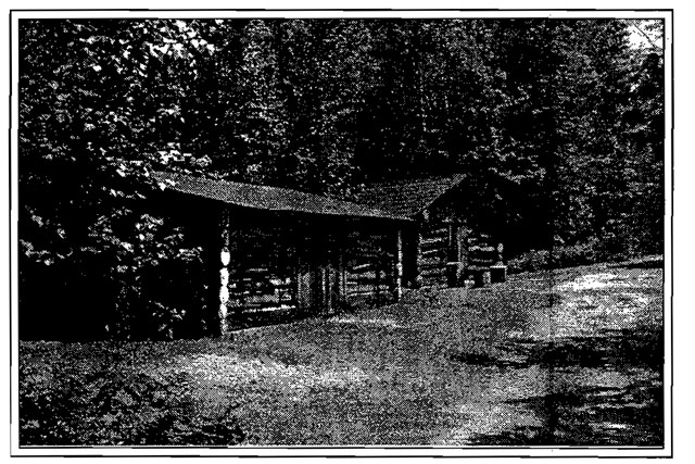
The replica 19th Century Logging Camp and museum consists of a restored cookhouse, office, bunkhouse, scaler’s shack, meathouse, horse stable, hay bam, and blacksmith shop. This setting contains original artifacts used during the square timber and saw-log eras of the logging industry. This exhibit also includes an out-of-doors display with logging sleighs, period snowplows, a water tanker, a jammer, a Barienger Brake, a roller, saw-log skidways and square timber. A feature film "The Winter Camp" takes the viewer back to the horse logging days of the turn of the century to tell the story of this important time in our cultural heritage. Guided tours of this exhibit are held regularly during the peak operating season. A guided nature walk on a 1,6 kilometre trail traverses the transitional forest and winds through remnant stands of virgin white pine, indicative of the pine forest logged here in the early 1900s.
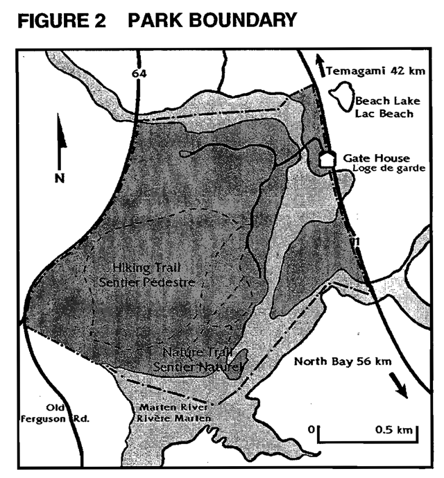
Figure 2 Park boundary
4.4 Tourism
To facilitate travel by residents of and visitors to Ontario who are discovering and experiencing the distinctive regions of the Province.
Marten River Provincial Park provides day-use and car camping for visitors travelling along Highway 11 or 64 as well as for those specifically destined for the park.
Marten River also offers an excellent opportunity through its shoreline sites and extensive trail system to enjoy the scenic beauty of the Marten River. Visitors to Marten River Provincial Park, especially long- term visitors, contribute to the local economy of the community of Marten River, North Bay and Temagami by purchasing goods and services in the area
5.0 Park boundary
Marten River Provincial Park is situated within the geographic Township of Siskin the District of Nipissing. Located along the Highway 11 corridor approximately 56 kilometres north of the City of North Bay and 42 kilometres south of the Town of Temagami (Figure 2). The park encompasses 400.249 hectares which includes waters and shoreline of the Marten River. The park is bordered by the Marten River to the north and south, the Old Ferguson Highway, Highway 11 to the east, and Highway 64 to the west. The eastern portion of the park is bisected by the Marten River.
6.0 Zoning
Recreation parks may contain five possible land use zones: access, development, nature reserve, natural environment and historical. Each zone permits certain land uses and outlines park management strategies. Through zoning policies, recreational areas are provided while features of biophysical and cultural significance are protected. The three types of zones that will guide resource management and development of the park are: development, natural environment and nature reserve zones (Figure 3).
6.1 Development zones (total 84 ha)
Development zones provide facilities and services for a wide range of day-use and camping activities. Marten River Provincial Park has two distinct development zones:
D1 Day-Use Zone (13 ha)
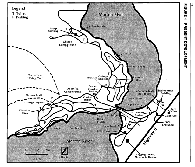
The Day-Use Zone is located between the eastern shoreline of the Marten River and Highway 11. The zone encompasses the park’s entrance, administrative offices, interpretive Logging Camp exhibit, maintenance buildings, staff residences,comfort station, pump house, main beach, and boat launch.
D2 Campground Zone (71 ha)
The Campground Zone is located along the western shoreline of the Marten River and encompasses two operational and one partially developed campground. Infrastructure includes paved roadways, a wood yard, hiking trailhead, two boat launches, two beaches, a comfort station with showers laundry facility, electrical sites and trailer dumping and water filling stations.
6.2 Natural environment zones (total 288 ha)
Marten River Provincial Park’s natural environment zones have been set aside in recognition of several significant features which exist in this area. A natural environment zone includes aesthetic landscapes in which there is a minimum amount of development required to support low intensity day use recreational activities. Permitted uses consist primarily of interpretive facilities such as trails, viewing platforms, signs or displays. The natural environment zones encompass four distinct areas:
NE1 Rolling Rockland (199 ha)
This uneven Rolling Rockland with a thin till mantle is located on the west-central side of the park and encompasses forests of balsam fir, red maple (Acer rubrum) and white birch. Scattered relic white pines are found in upland sites and a variety of wet shrub swamp forests and shrubs in small valley basin sites exist. The interpretive hiking trail passes through this area. This zone also includes the waters, within the park boundary, of the Marten River.
Figure 3 Zoning within Marten River Provincial Park
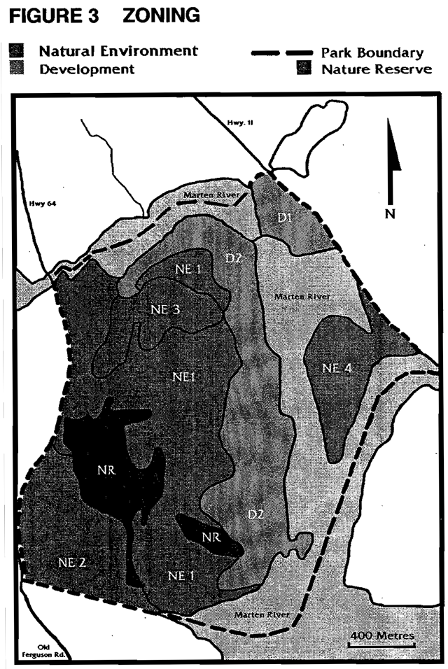
NE2 Southwestern Till Ridge Forests (44 ha)
The Southwestern Till Ridge Forests are located in the south west section of the park and are reported to be on deep till deposits forming ridges with little bedrock control(lumbers, 1971). The predominant forest types here are deciduous (maple-birch) and mixed (pine-maple),with intermediate age communities. Rocks carried a distance by glacial ice can be found in this zone. This zone is adjacent to the south boundary of the park where an extensive shallow lake bay exists. The hiking trail passes through this zone.
NE3 Northwestern Till Ridge Forests (19 ha)
The Northwestern Till Ridge Forest is located in the north central section of the park. This zone also is reported to have deep till deposits forming ridges with little bedrock control (lumbers,1971),but may have a higher diversity of forest community patterns than that exhibited in NE2. A small gravel borrow pit is located here.
NE4 Eastern Upland and Lowland Mixed Forests (26 ha)
East of the main park core, adjacent to Highway 11, there are no roads, trails or known cultural features in this area. This zone is centered on a point with two and one half kilometres of shoreline on an inside bend on Marten River. A lowland black ash swamp forest parallels the highway and provides a natural separation of upland stands to the south. The upland forest is mostly large diameter sugar maple and yellow birch with scattered tall emergent white pine.
6.3 Nature reserve zone (28 ha)
A nature reserve zone represents distinctive habitats and landforms and is protected for educational purposes, research and intrinsic value.
NR Peat/and Basins
The Peatland Basins are located on the south-central side of the park. The area depicts two separate, poorly drained basins where the peat is generally more than two metres thick but with local interior bedrock exposures. The larger of these two basins is dominated by low shrub growth with scattered black spruce trees. The smaller basin is wetter with more moss visible among the shrubs and only a few stunted spruce trees. Boardwalks along the interpretive trail take hikers through these basins. Past logging disturbance is evident in both basins.
7.0 Resource management policies
Management of the resources within Marten River Provincial Park will be implemented in accordance with the Management Plan and conform to the Ontario Provincial Parks Planning and Management Policies for a recreation class park.
Changes to provincial park policies as a result of Ontario’s Living Legacy Land Use Strategy (1999) do not affect trapping and baitfish management in Marten River Provincial Park as there are no traplines or baitfish licences within the park.
7.1 Mineral exploration
Mineral exploration and mining are not permitted within the park. Whensand or gravelis required for major maintenance and capital improvements, it will be brought in from an external source. An Aggregate Resources Rehabilitation Plan for the smallgravel borrow pit in NE3 will be prepared to provide for ongoing rehabilitation needs.
7.2 Adjacent land management
A provincial land use planning initiative, initially called Lands for Life, commenced in 1997 to identify various land use allocations and use management policies on Crown land in central Ontario. The next phase of this initiative produced Ontario’s Living Legacy Land Use Strategy (July 1999). Prevailing policies and the following protected areas, in proximity to the park, are identified in the Land Use Strategy:
McLaren Forest Conservation Reserve (C159)
This site of old growth white pine is the most accessible and the oldest old growth site in sitdistrict 4E-4. Some trees area at least 220 years old. The pine grows on rolling hills with bedrock and pockets of flat sedimentary deposits. It is located partly within the Nipissing Game Preserve, and southwest of Marten River Provincial Park. Mclaren Forest has excellent interpretation value and there is potential for Marten River Provincial Park to provide interpretation of the site.
McLaren Forest, approximately 369 hectares, will be regulated as a conservation reserve under the Public Lands Act. Values and permitted uses are described in more detail in Ontario’s Living Legacy Land Use Strategy (1999).
Temagami River Provincial Park (P139)
A 30 kilometre section of the Temagami River,a white water route, is located between Cross Lake and Red Cedar Lake to the bridge crossing north of River Valley. Rapid sections like Ragged Chutes, attract expert canoeists. This bedrock controlled drainage has some very scenic sections with small islands and a narrow gorge. Shorelands are forested with white pine, jack pine and poplar. The river is in site districts 5E-6 and 5E-4 and encompasses approximately 2,836 hectares. Values and permitted uses are described in more detail in the Land Use Strategy.
Marten River (E154r. recreation)
This area is southeast of the park and encompasses approximately 72,816 hectares. The Marten River enhanced management area includes a wide range of values including resource extraction, recreation, wildlife management, drive in and semi remote tourism, and natural heritage protection (existing and new protected areas). This area will be managed as an important tourism and recreation area. Further information on values, permitted uses and land use intent are described in more detail in Ontario’s Living Legacy Land Use Strategy (1999).
Marten River Kames (E155n. natural heritage)
This area of earth science significance in site district 4E-4 contains a significant kame field located adjacent to Marten River Provincial Park. The kame hills - massive unsorted piles of sand, gravel and boulders - are dissected by eskers and former stream beads. This enhanced management area encompasses approximately 590 hectares. Forest management is permitted, provided that it is consistent with the protection of earth science natural heritage values. Aggregate extraction is not permitted within this area, due to the significance and sensitivity of the earth science values. Values and permitted uses are described in more detail in Ontario’s Living Legacy Land Use Strategy (1999).
7.3 Vegetation management
A Vegetation Management Plan will be developed for the park. Commercial harvesting of timber is not permitted in the park. Trees removed for the purposes of management or development may be used for park purposes.
The Vegetation Management Plan will have different prescriptions for each zone. The following describes these different prescriptions:
Natural environment zones
Vegetation in these zones will follow a natural process of succession. Vegetation may be altered only for purposes of trail development, safety, and the establishment of viewpoints.
Development zones
Vegetation may be removed along park roadways and in the campgrounds for reasons of safety, trails, campsites and playground construction, and for improving viewpoints or aesthetic enhancement along the park entrance. Permanently closed sites will be reforested. Some over-used sites may be closed periodically for rehabilitation. Efforts will be made to establish natural screens between campsites. Vegetation management programs will be employed as required to maintain a healthy overstorey of varying ages in the campgrounds.
Forest and vegetative insects and diseases threatening values inside or outside the park may be controlled. Biological controls will be used in preference to chemicals, where feasible. Where control is desirable, it will be directed so as to have minimal environmental impact.
A vegetation survey will be completed for the park to provide baseline information for future monitoring purposes, to complement the natural heritage education programs and to assist with park boundary definition.
7.4 Fisheries management
Marten River and its tributaries provide excellent opportunities for sport fishing. Prevailing plans and regulations for monitoring, seasons, catch and possession limits will apply.
A proposed partnership agreement with the Marten· River Tourist Association (Economic Development Committee) will be evaluated to determine if small rearing ponds for walleye and a hatchery facility may be constructed in the park. These small rearing ponds and hatchery will help support the area’s fishery. The hatchery and ponds will be operated by · agreement with the interested party and will meet all regulations and guidelines. The proposed area for the pond is adjacent to the main park road on the north side of the river, in the development zone. The site was previously disturbed by development. If deemed feasible, a site plan will be developed for this small rearing pond and hatchery facility.
7.5 Wildlife management
Due to the limited size of the park and the availability of hunting opportunities in the surrounding area, no hunting will be permitted within the park.
Maintenance of park resources, property, as well as the safety of visitors may require the control of select animals. This will be carried out under the supervision of Ministry of Natural Resources personnel.
7.6 Water management
Water quality will be maintained for consumption and swimming. The parks water treatment and water quality sampling program will continue to ensure that provincial standards are met.
The beaches at Marten River ProvincialPark are subject to debris accumulation due to their location with respect to currents andprevailing winds. Some minor fluctuations (daily or seasonal) in water levels also occur.
While problems affect the water quality for recreation, this Ministry must deal with them as part of the normal maintenance program.
7.7 Fire management
The park will be managed for fire on the basis of the Fire Area Strategies for the land base. Approved methods of fire detection and suppression will be implemented to protect life, property and park resources.
8.0 Operations Policies
Marten River Provincial Park represents a variety of natural and cultural heritage resources which can provide excellent recreational and tourism opportunities. This Management Plan outlines the future development of the park resources as well as operational policies. A Park Operating Plan, consistent with the approved Ontario Provincial Parks Minimum Operating Standards, will be available for park staff. The Operating Plan will provide the necessary information required to operate the park on a day to-day basis. The Operating Plan includes such topics as budget, staffing, and maintenance schedules, enforcement and emergency procedures. Operations policies also incorporate natural heritage education, recreation management, tourism services, and marketing. These components are described in more detail in the following subsections. The Park Operating Plan will be reviewed annually and updated as required.
Any proposals that require funding in support of the development of new facilities must be supported by a business case.
8.1 Natural heritage education
Marten River Provincial Park will operate with a seasonal activity level of natural heritage education (NHE).The NHE program will meet the basic requirements and level of provincial standards for a seasonal classification.
A park Natural Heritage Education Plan will be prepared to organize park themes and methods to inform park visitors of the natural, cultural and recreational resources of the park and the local area. The plan will also outline park programs, facilities and rules, and encourage communication between visitors and park staff. Potential interpretation opportunities of adjacent protected areas (e.g. McLaren Forest Conservation Reserve) will also addressed. A new Visitor’s Centre may be constructed, in the Development Zone (01), to facilitate NHE staff and these programs.
Criteria for selecting programs will be based on their potential to encourage the appreciation and protection of the park and the appreciation of its natural and cultural themes. Programming will integrate staff in "period costumes" to create a working exhibit (e.g. an operational blacksmith’s shop).
Private sector opportunities to participate in natural heritage education activities through interpretive services or related business ventures may be considered.
Natural heritage education will consist of the following three components: information, interpretation and recreation.
Information
Information on the natural and cultural heritage of the area, recreational opportunities, park services and facilities will be available at the park office, in park publications and on bulletin boards.
Information about the park facilities, trails, Logging Camp exhibit and Natural Heritage Education camp tour times, special events, trail information, other ongoing programs, orientation to old growth as a managed resource today) will be available. Information on recreation trails, hunting and fishing opportunities in the local area outside the park will be available.
Park information may also promote the Logging Camp exhibit through the use of icons and posters etc. on park brochures, signs and other park publications. This will complement the heritage appreciation objective of the park.
A trailside site display system or signs will also be used to educate visitors of significant features along trails. Cultural resource information such as local history, and local events and activities will be provided in brochures and displays.
Interpretation
Marten River Provincial Park has considerable interpretive potential. A variety of life science, earth science and historical themes are represented in the park and vicinity. Interpretive programs will be offered on a seasonal basis. Self-use activities will also be present. Special programs or guest speaker events may be scheduled for park interpretation purposes.
Life science themes include: the transitional zone between the northern boreal forest and the deciduous woods of the south; and the ecology of Eastern White Pine.
Earth science themes include: some geological features adjacent to the park that represent aspects of the processes that formed the Canadian Shield; and glacial landforms on the local landscape.
Historical themes include: local settlement history represented by such features as a replica 19th Century Logging Camp exhibit, complete with nine buildings and numerous artifacts used by lumbermen at the tum-of-the century; the days of the massive log drive; and, the voyageurs and early explorers.
Recreation
Programs may be offered by park staff, interested groups and agencies to develop the outdoor skills of park visitors. Programs providing instruction of skills such as canoeing, backcountry travel and camping, angling, and bird-watching may be provided.
8.2 Research
Scientific research, by qualified individuals, that contributes to the knowledge of natural and cultural history and to environmental and recreational management, will be encouraged in the park. Ontario Parks will encourage institutions to undertake research projects. Park resources that may present opportunities for research include remnant old growth white pine and the vegetation contained in the peatland basins. Research that may be used to enhance the operations of the park and the delivery of natural heritage education programs will also be encouraged. All research programs will require the approval of Ontario Parks and will be subject to park policy and other applicable Legislation. Ontario Parks may approve the research of any natural or cultural specimens by qualified researchers. All such materials removed remain the property of the Ontario Ministry of Natural Resources.
Approved research activities and facilities will be compatible with the park’s protection objective. Any site that is affected will be rehabilitated as closely as possible to its original state.
8.3 Recreation management
Marten River Provincial Park has potential for both summer and winter trail use. It contains an array of scenic landscapes and forested areas are mixed and include old growth white pine. The park offers extensive water access, is close to a major travel corridor, Highway 11, and is located close to the potential development of a regional trail network. Trails originating in the NE2 zone may connect to such a regional network.
There are two existing trails in Marten River Provincial Park. The Transition Hiking Trail (5 km) provides a route through the transitional woodlands and a black spruce (Picea mariana) bog. It is marked by scattered remnants of old growth white pine (Pinus strobus), with one stun11ing example aged to be more than 300 years old; The Nature Trail (1.6 km) highlights succession in the transitional forest and the bird, animal and plant life it contains.
The trail system will be monitored for safety and environmental concerns. A number of unofficial trails (footpaths) have been created, causing gullying on the steeper slopes. Site planning will evaluate the trail system and redesign to identify strategies to manage areas where footpaths are not required where use is. causing erosion. Impacted areas will be closed off and rehabilitated. To facilitate winter access and augment existing cross- country skiing opportunities, trail extensions may be developed. Additional trails will be developed according to an approved trail plan.
Motor vehicles and motorized snow vehicles, as defined in the Highway Traffic Act, will be allowed in the park only on designated roads or trails except where required for development, management or emergency purposes by Ministry personnel. A partnership agreement, between the park and the Ontario Federation of Snowmobile Clubs, may be developed for the provision of a snowmobile trail through the park.
Group camping (e.g. boy scouts, girl guides, other organizations…) will be permitted in the group camping area. Groups of up to 100 can be accommodated. Groups wishing to camp must receive pre-authorization from the Park Superintendent.
8.4 Tourism services
Marten River Provincial Park serves as an information outlet, supplying tourism information to travellers along the Highway 11 corridor. It may also serve to market provincial parks further along the route. Marten River Provincial Park also functions as a perimeter park to the Temagami area backcountry parks, providing additional camping facilities as well as information concerning backcountry parks recreation. The park’s location along the Marten River plays a role in tourism services through the promotion of the river’s ·recreational opportunities and the local recreational services (e.g. outfitters, boat rentals, etc.).
There are businesses north and south of the park that provide gas and restaurant services and may be locations to promote the park.
8.5 Marketing
A Sign Plan will be developed tor the park. The park will also be marketed to its capacity. This will include promoting the park’s replica Logging Camp exhibit, cross-country skiing opportunities, access to the Marten River and other area waterways, angling opportunities, group camping and the park’s shoreline campsites. Park brochures will be supplied to other Provincial Parks, communities and tourist information centres north and south along the Highway 11 corridor.
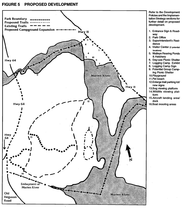
9.0 Development policies
Development policies use the resources of the park to allow for further recreational activities and interpretation opportunities while protecting the parks natural features. Development will proceed in accordance with the policies of this approved Management Plan, Management Policies, Provincial Park Development Standards, and approved site and development plans. In all instances, approved, detailed site plans will precede all development. The requirements of the Environmental Bill of Rights, the Environmental Assessment Act and other pertinent acts will be adhered to.
All proposed development is illustrated in Figure 5 and is described in the following sections:
9.1 Park entrance
The entrance roadway into the park will be realigned to afford ease of access to the park. Site evaluation and planning will determine the location of the road realignment.
A new park entrance sign will be designed and installed to replace the existing sign. Standard Ontario Parks road signs will be located on the Highway 11 corridor promoting the Logging Camp exhibit. These will be designed and installed so both north and south bound travellers are informed of this major attraction in the park.
A sign informing northbound traffic on Highway 11 about the Logging Camp exhibit will be located in the park along the shoreline of the Marten River. Site planning will determine how this sign will relate to the Logging Camp exhibit.
9.1.1 Gatehouse/park office
The existing gatehouse which contains the hydro distribution panel for the comfort station and park office, will be removed. The panel will be encased on its own or a direct hydro line may be connected to the comfort station and office.
Currently, gatehouse operations are located in the park office building. The existing office should be upgraded (e.g. heating and security systems, office space) or relocated to adequately support administrative functions. Should the existing building no longer meet standards a new building and support facilities will be constructed. Site plans will be developed to accommodate a larger parking area for registering visitors.
A functional assessment of the park entrance area (e.g. office, gatehouse, road, signage…) will be prepared.
9.2 Campground facilities
The Marten River Provincial Park Management Plan makes provisions for upgrading facilities in the existing campgrounds and for campground expansion. The majority of the park’s 190 campsites are concentrated along the west shore of the Marten River.
In 1997, campsite occupation was 3,517 with a revenue of $45,600. In 1998, the addition of 32 electrical sites contributed to the increase of occupied campsites (this includes seasonal leased sites) by 33% and the park’s revenue by 35%. (OMNR, Park Statistics, 1997 &1998)
9.2.1 Campground expansion
Campground expansion near Assinika may occur if a need is shown or to replace campsites removed for the purpose of rehabilitation or for the reason of negative aesthetics. A roadway in this proposed third campground (Ansig Campground) is partially constructed.
9.2.2 Boat mooring
The feasibility of developing a boat mooring facility in each of the campgrounds will be evaluated. Such facilities could be developed to reduce potential conflicts between boat launch users and for reasons of property protection and safety.
9.2.3 Vault privies
A number of existing vault privies in Assinika and Chicot campgrounds will be retrofitted with flush toilets.
9.2.4 Group camping area
A picnic shelter will be constructed in the group camping area to provide shelter for group campers.
9.3 Day-use facilities
Day-use facilities are located on the east side of the park between the Marten River and Highway 11. A grassy backshore area behind the beach contains washrooms, water taps, picnic tables, children’s swings, volleyball area and horseshoe pits.
9.3.1 Picnic shelter
Old privies altered for use as change houses will be removed in order to accommodate a picnic shelter which has been proposed in the backshore area. This will provide shelter for day users.
9.3.2 Boat launch/aircraft landing area
The present boat launch will be upgraded with a new dock and boat slip extensions to accommodate boaters.
An aircraft landing area with a dock for float planes has been proposed to accommodate fly-in visitors and emergency aircraft (e.g. firefighting aircraft, air ambulance). A heli-pad is also located across the Highway from Marten River Provincial Park.
9.3.3 Comfort station
The existing day-use comfort station will be upgraded.
9.3.4 Beach area
The backshore area of the beach will be rehabilitated to reduce steep sloping. Beach sand will be added. Both measures are aimed at increasing comfort and safety at the beach. To avoid possible damage to the environment a silt barrier will be put in place before any work begins.
A beach allowing domestic animals may be developed to accommodate the growing number of visitors who have pets.
9.3.5 Rearing ponds/hatchery
Construction of walleye rearing ponds and a hatchery facility may take place. These small ponds will increase visitors' awareness of the need to protect and enhance natural resources. This facility will be managed through agreement by the Marten River Tourist Association (Economic Development Committee) and constructed in conjunction with the Northern Ontario Heritage Fund.
9.3.6 Visitor centre
A multi-purpose Visitor Centre will include areas for local outfitters to display their businesses; reception area; NHE staff offices and archives; and audio-visual promotion displays. A store will be included retail park-related merchandise. This will not conflict with nearby private business.
9.3.7 Playground
Playground equipment (e.g. slides, teeter-totters) will be provided for the amusement of children. Site planning will determine a suitable location between the day-use beach and the Logging Camp exhibit for the playground.
9.4 Administrative and operation facilities
9.4.1 Park Superintendents residence
Renovations will take place at the Park Superintendent’s residence to replace deteriorating fascia and outside trim.
A security system may be installed in the Park Superintendent`s seasonal residence.
9.4.2 Maintenance building
A security system may be incorporated into the existing maintenance building to provide added security in the non operating season.
9.4.3 Park boundary
A resurvey and posting of the park’s south boundary is required.
9.4.4 Water lines
Older, smaller water lines within the park will be replaced with larger lines to adequately meet water circulation needs. Additional water taps will be provided.
9.5 Natural heritage education facilities
The park’s Logging Camp exhibit, a tourist attraction, built in the early 1980s has begun to show signs of deterioration in several of the nine buildings comprising the exhibit. The Logging Camp exhibit will be upgraded and enlarged and new artifacts added. Heating and ventilation will be installed at the camp’s museum/theatre and projection equipment will be upgraded.
Staff will explore any opportunities for shoulder season programs that include on site residency of the Logging Camp with interpretive programs.
The trail system within the park provides insights to a variety of earth and life science interpretive themes. The Transition Forest Hiking Trail which passes through a black spruce bog and transition forest containing remnant old growth white pine contains plaques interpreting various aspects of the forest An extension of this trail will be completed, passing through a small stand of old growth white pine which will contain interpretive plaques.
9.6 Recreation facilities
9.6.1 Trails
An effective trailhead sign with map, photographs and relevant text will be designed and erected for the existing Transition Forest Hiking Trail. A small parking lot at this trailhead will be expanded to accommodate the current overflow from those using the trail.
A wildlife viewing platform will be constructed on the Transition Forest Hiking Trail in the area where it meets an embayment of the Marten River. This will afford visitors a better opportunity to view the many species of wildlife which inhabit this extensive shallow lake bay. Construction of a trail through mixed forest containing old growth white pine will be completed. Viewing platforms will also be constructed in the nature reserve zone.
A trail designed specifically for mountain biking may be constructed within the park following studies to determine its impact potential and maintenance requirements. This trail may be linked to the Discovery Routes Partnership trails.
The feasibility of adding cross-country ski trails will be studied. This could include offering a winter program and opening some Logging Camp exhibit buildings for winter use.
9.7 Partnerships
Emphasis will be given to develop partnerships for such items as development proposals, recreation, and other activities.
This Management Plan encourages continued dialogue on matters including but not limited to the following:
- partnership agreement with the Marten River Tourist Association (MRTA) or its offshoot organizations on co development of facilities (e.g. fish hatchery and rearing ponds) at the park;
- agreement with MRTA (Economic Development Committee) to determine if small rearing ponds for walleye and a hatchery facility may be constructed in the park;
- agreement between the park and the Ontario Federation of Snowmobile Clubs on the provision of snowmobile trails through the park; and,
- promoting area businesses offering services compatible with park objectives.
10.0 Implementation strategy
The Marten River Provincial Park Management Plan will be reviewed as needed in the future. More frequent reviews may occur if deemed necessary. Once approved, amendments to the Management Plan may be made at any time should the need be identified, in compliance with the prescribed planning process and required public consultation. Meanwhile, the development of facilities as described in this Management Plan (Figure 5) will proceed and are based upon the availability and allocation of normal budget and capital funding each year.
Projects
Completion of this phase will provide basic guidelines for future development and operations:
Phase 1
- Update the park Operating Plan.(section 8)
- Prepare an Aggregate Resources Rehabilitation Plan for gravel borrow pit. (section 7.1)
- Prepare the Natural Heritage Education Plan. (section 8.1)
- Investigate various partnerships (e.g. hatchery and rearing ponds agreement, etc.). (section 7.4, 8.3 & 9.7)
- Prepare a park sign plan. (section 8.5)
- Prepare a park trial plan. (section 8.3)
- Complete a vegetation survey of the park and prepare a Vegetation Management Plan. (section 7.3)
- Park entrance complex functional assessment (e.g. road, gatehouse, park office, signage…). (section 9.1)
- New Entrance sign(s). (section 9.1)
Phase 2
Completion of this phase will provide basic facilities to encourage a more stable and positive financial contribution to the parks system.
- Renovations to the Park Superintendents residence to replace deteriorating, fascia and outside trim. A security system may be installed. (section 9.4.1)
- Construct picnic shelters at group camping and day-use beach. (section 9.2.4 & 9.3.1)
- Upgrade existing day-use area comfort station. (section 9.3.3)
- Upgrade of existing hiking trails following approved site plans and construct new trails which include: trailhead signs, interpretive plaques, raised viewing platform, wildlife viewing platform, parking lots, and cross country ski trails, and a potential linkage with Discovery Routes Partnership trails. (section 8.3, 9.6 & 9.7)
- A park entrance area will be re-designed as per the functional assessment. This will include renovations or reconstruction of the park office, rerouting of entrance roadway leading to office and expansion of parking lot. (section 9.1 & 9.1.1)
- The existing gatehouse will be removed. The distribution panel may be encased or a direct line may be connected to the comfort station and park office. (section 9.1.1)
- Upgrade and enlarge Logging Camp exhibit buildings; addition of heating and ventilation to museum; upgrading of projection equipment; provision for transforming exhibit into an operational camp. (section 8.1 & 9.5)
- Construct a multi-purpose Visitor Centre with NHE staff offices, archives, promotion display area, park merchandise store, and area for local businesses to display their services. (section 8.1, 9.3.6 & 9.5)
- Upgrade of water lines. (section 9.4.4)
- Retrofit existing vault privies with flush toilets. (section 9.2.3)
- Rehabilitate the day-use beach to reduce steep sloping. (section 9.3.4)
- Develop boat mooring facilities with boat slip extensions in campgrounds and day use areas. (section 9.2.2)
- Construct walleye rearing ponds and a fish hatchery facility. (section 9.3.5)
- Addition of playground equipment. (section 9.3.7)
- Develop a beach area for pets. (section 9.3.4)
- Expand campground by further developing Ansig campground. (section 9.2.1)
- Resurvey and post the southern park boundary. (section 9.4.3)
- Install a security system in the maintenance building. (section 9.4.2)
- Upgrade boat launch. (section 9.3.2)
- Consider feasibility and development of dock for aircraft. (section 9.3.2)
10.1 Social and economic impact analysis
Marten River’s visitation has fluctuated in recent years. In 1996, occupancy of the campgrounds during the July-August peak season averaged 57%. In 1997, July-August occupancy averaged 74%. During the 1998 operating season, occupancy during the peak July-August season averaged 64%.
Expenditures made by Ontario Parks to operate Marten River, and by park patrons who visit the park, translate into economic impacts (figures related to visitor expenditures were drawn from the 1998 Park User Survey). Based on an initial total expenditure of $574,000, the following economic impacts were generated using the Social and Economic Impact Model, (SEIM) licensed to MNR:
- Regional Gross Sales (or Regional Gross Output) - $1,461,600.00
- Wages & Salaries - $465,631
- Provincial Person Years of Employment - 15.7
- Regional Person Years of Employment - 8.8
The operation of the park and the related expenditures have a positive social and economic effect on the surrounding area.
11.0 Public consultation
The planning process followed several methods of consultation which enabled the public to comment during the management planning for Marten River Provincial Park.
These methods consisted of:
Mailing lists
- Mandatory mailing list (PM 11.02.02).
- Mail out of Preliminary Management Plan to those on the mandatory mailing list and to individuals who requested to be put on the mailing list.
- Mailing list of local residents and businesses.
- A notice indicating plan approval and where copies may be obtained was mailed to mailing list members.
Newspaper notice
- Newspaper notices in the: North Bay Nugget, Sturgeon Falls Tribune, Timiskiming Speaker, and the Kirkland lake Northern Daily News.
Public meetings
- Public meetings on request or as the Superintendent deemed necessary were held over the duration of the project.
Environmental Bill of Rights Registry
- EBR Notices were posted (during the Invite to Participate, Preliminary Plan and Approved Plan stages) which provided the opportunity for public comment.
Comment sheet
- The Preliminary Management Plan included a comment sheet for public input and submissions were directed to the Park Superintendent.
During the management planning process public comments were received. Many verbal comments were received as well as 22 written responses. Public response was positive.
All comments received were considered during the completion of this Management Plan.
12.0 References
Foot, David K., 1994. Boom, Bust & Echo, How To Profit from the Coming Demographic Shift, Macfarlane Walter & Ross, Toronto, 1996.
Lumbers, S.B., 1971. Geology of the North Bay Area Districts of Nipissing and Parry Sound. Ontario Department of Mines and Northern Affairs. Toronto, ON.
Ontario Ministry of NaturalResources,July 1999. Ontario’s Living Legacy Land Use Strategy. Queen’s Printer for Ontario.
Ontario Ministry of Natural Resources, 1996. Marten River Provincial Park Business Plan, Marten River.
Ontario Ministry of Natural Resources, 1994. Barrier Free Guidelines Design Manual, Vol. 3, Peterborough, 1996.
Ontario Ministry of Natural Resources, 1994. Ontario Provincial Parks Management Planning Manual, Parks Planning Section, Toronto.
Ontario Ministry of Natural Resources, 1994. Ontario Provincial Parks Statistics, Queen’s Printer.
Ontario Ministry of Natural Resources, 1992. Ontario Provincial Park Planning and Management Policies, Queen’s Park.
Ontario Ministry of Natural Resources, 1991. Visitor Services Plan, Northeastern Region, Sudbury.
Ontario Ministry of Natural Resources, 1987. Marten River Provincial Park Marketing Plan, Marten River.
Ontario Ministry of Natural Resources, 1983. North Bay District Land Use Guidelines, OMNR,North Bay.
Ontario Ministry of Natural Resources, 1980. Marten River Provincial Park Life Science Features, lan D. Macdonald, Northeastern Region Division of Parks.
Ontario Ministry of Natural Resources, 1976. Marten River Provincial Park Management/Operating Plan, OMNR.
Quinby, Peter A., 1993. Ancient Forest Exploration Guide, Ancient Forest Exploration and Research, Powassan.
Trapp, S., Gross, M. and Zimmerman, R., 1994. Signs, Trails, and Wayside Exhibits, University of Wisconsin Foundation Press Inc.