Nagagamisis Provincial Park Management Plan
This document provides policy direction for the protection, development and management of Nagagamisis Provincial Park and its resources.
July, 1980
Minister’s approval statement
In accordance with The Provincial Parks Act, Section ld and 7a, I am pleased to approve the Nagagamisis Provincial Park Master Plan as the official policy for the future development and management of the park. This plan signifies the culmination of several years of policy and management planning and public participation.
Nagagamisis Provincial Park, located 100 km southwest of Hearst, is situated on the western fringe of the Great Clay Belt of Northeastern Ontario. Since its official opening in 1957, Nagagamisis has served primarily as a destination camping area for both local and non-local visitors. While ensuring the provision of high quality recreational opportunities, the Master Plan stresses protection of the park’s significant cultural and natural resources.
Finally, I would like to extend my gratitude to those individuals and groups who provided the valuable commentary during the public participation program.
Signed,
James A.C. Auld
1.0 Introduction
The Nagagamisis Provincial Park Master Plan establishes policies for the planning, development and management of park resources. Three major sections make up the master plan: the background information section which describes the resources of the park, their significance and sensitivity; the park policy section which identifies general and specific park policies; and, the park development and management section which identifies the projected phases of development which the park will pass through and the management guidelines to be used to manage park resources.
2.0 Regional setting
2.1 Park location
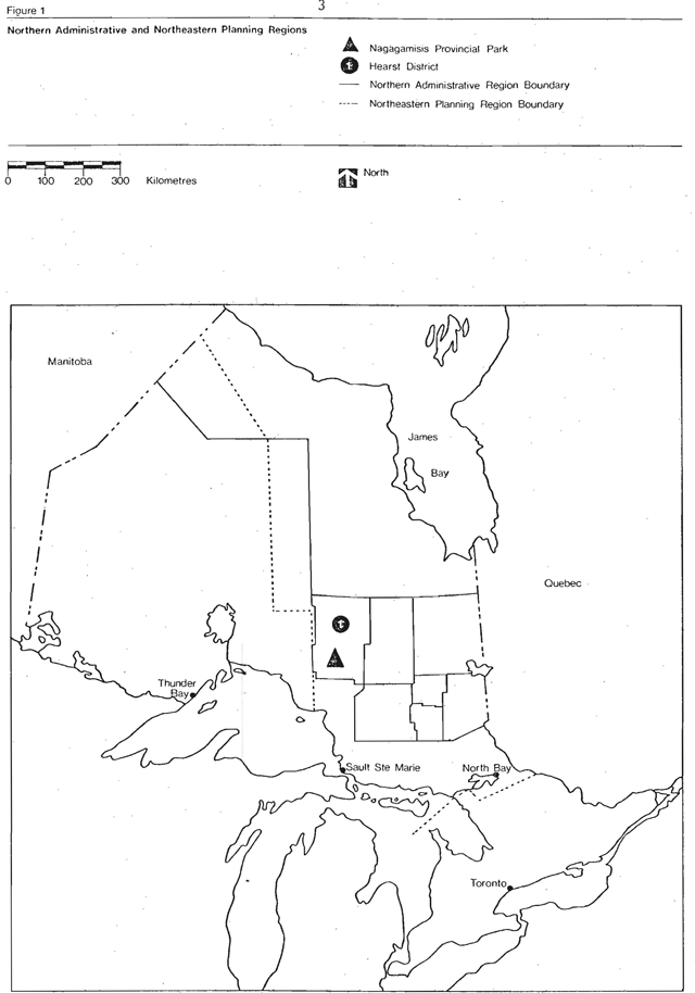
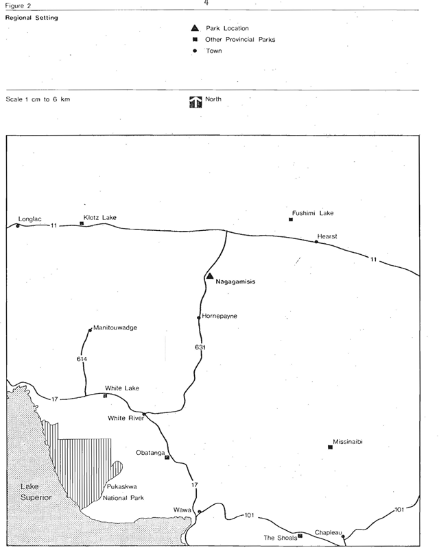
Nagagamisis Provincial Park is located in the Hearst District which is part of the Northern Administrative Region, Ministry of Natural Resources. The park is also found in the Northeastern Planning Region as defined in the Strategic Land Use Plan of the Ministry of Natural Resources (Figure 1). It situated on the western fringe of the Great Clay Belt of Northeastern Ontario, 100 km southwest of Hearst, 32 km north of Hornepayne and 440 km north of Sault Ste Marie (Figure 2).
2.2 Regional economy
A slow growing economy and few non-resource oriented manufacturing industries best typifies the Northern Administrative Region. The major sources of employment are forest and forest-based activities, mining and mine-based industries, agriculture and tourism. Commercial fishing and trapping provide employment on a seasonal or part-time basis. Secondary industries dependent on mining and forestry include transportation and construction. Government services also play an important role in the economic base of the region.
Figure 1: Northern administrative and northeastern planning regions
Enlarge figure 1: Northern administrative and northeastern planning regions (PDF)
Figure 2: Regional setting
Enlarge figure 2: Regional setting (PDF)
2.3 Population
The Northern Administrative Region of the Ministry of Natural Resources is within the Northeastern Planning Region of the Ministry of Treasury, Economics and Intergovernmental Affairs (TEIGA). In 1971, the resident population of the Northeastern Region was approximately 560,000 or 7.3 percent of Ontario’s population. The population of Cochrane Census District in 1971 was about 96,000 or 17 percent of the population of the region.
Within a radius of 200 km from Nagagamisis Provincial Park there are four major municipalities: Kapuskasing, Hearst, Hornepayne and White River with populations of 12,520, 5,000, 1,800 and 1,000 respectively. These centres were traditionally important to the forest industry, but have recently taken on additional roles. White River, Hearst and Kapuskasing have become important government centres while Hornepayne is a Canadian National Railway service depot.
Including the population of smaller centres as well as the scattered rural population, the total population within 200 km is approximately 30,000.
Local services including medical, shopping, police, churches, accommodation, food, fuel and entertainment are available at Hornepayne (32 km south of Highway 631) or at Hearst (100 km northeast via Highways 631 and 11).
2.4 Access
The Northern Route of the Trans Canada Highway (#11) provides access to Nagagamisis from the north while the Lake Superior Route of the Trans Canada Highway (#17) provides access from the south (Figure 2).
Secondary accesses include Highway 144 north from Sudbury, Highway 129 north from Thessalon and Highway 101, east to west, from Timmins to Wawa.
The nearest railway station is located at Hornepayne where the Canadian National Railway line provides daily service between North Bay and Longlac. The Canadian National Railway also runs adjacent to Highway 11, passing through Hearst and connecting in Kapuskasing with the Ontario Northland line from Cochrane to North Bay. Bus service is available at Hornepayne (Canadian National) and Hearst (Ontario Northland). The nearest municipal airport is located at Kapuskasing where NorOntair provides regular daily service. Float plane air bases exist on Carey and Johnson lakes while a municipal airstrip is located at Hornepayne.
Access to the park can also be gained via the Nagagami and Nagagamisis rivers or the numerous interconnected creeks and lakes flowing into Nagagamisis Lake.
3.0 Market analysis
3.1 Regional recreation supply
The trends in recreation demand for the Northern Administrative Region are changing. Several factors which are contributing to these changes are:
- lower reproduction rates;
- migration from Ontario;
- changes in the attractivity of Ontario as a tourist destination;
- increases in winter vacation trips; and
- increased energy costs.
Although recent survey data
Another factor which appears to be affecting tourism in the north is the decrease in the average length of vacation trips taken by car. Since the Northern Region requires a long trip from the main market sources, the effects have been noticeable. Further trends have occurred particularly in the purpose of the vacation trips and types of experiences sought. In the latter case, it seems that vacationers are interested in spending time at vacation spots. The north has a deficiency of these year-round attractions.
The Northern Administrative Region contains a substantial number of attractive well-equipped private and public campgrounds and parks and excellent fishing and hunting opportunities. The region also offers a wide range of commercial tourist establishments with 136 commercial cabins and cottages, 43 lodges and resorts and 29 hotels and motels (S.L.U.P., 1976). For visitors seeking fly-in hunting and fishing opportunities, 20 outfitters are available and for the travelling public approximately 37 commercial tent and trailer campgrounds exist.
Vast amounts of accessible Crown land are also available for those local and non-local users seeking a more unstructured recreational experience.
Though the region has considerable potential for tourism, it has faced problems of distance from major markets. This, coupled with increased fuel costs and a decrease in the average length of vacation trips taken by car, have resulted in quite noticeable effects. Given these factors, tourism still remains a major industry in the North. In fact, use of many northern parks cannot be directly correlated to the socioeconomic traits of the surrounding population. Rather, it is traced to a majority of users who travel north from Southern Ontario and the United States.
Seventeen provincial parks situated throughout the Northern Administrative Region, provide approximately 1,200 developed campsites. In addition, 123 access points and 46 designated canoe routes further supplement the regional recreational supply. Private recreation facilities also contribute to the total recreation supply. These include approximately 3,595 private cottages and 673 hunt and fish camps.
3.2 Local recreation supply
There are four provincial parks within a 150 km radius of Nagagamisis. Klotz Lake and Fushimi Lake provincial parks provide intervening opportunities for travellers on Highway 11 while White Lake and Obatanga provincial parks provide alternative opportunities for visitors travelling Highway 17. Only Obatanga is classed a natural environment park, the other three are classed as recreation parks. It remains uncertain whether any or all of these parks has any influence on visitor use at Nagagamisis.
There is only one park reserve located in the Hearst District:
Nagagami Lake Park Reserve (1,481 ha) located southwest of Nagagamisis on Nagagami Lake. The extent of influence that this park reserve will exert on the park should it become a provincial park, depends on the type of facilities provided and its relative ease of access.
Also within the Hearst District are 14 official access points and 7 designated canoe routes, all of which provide opportunities for backcountry travel on Crown land.
Highway corridor 631, linking Highways 17 and 11 offers both the local and touring public with a wide variety of recreation opportunities (The Crown Land Recreation Study, 1977). Approximately 89 percent of the land adjacent to this corridor is Crown land. The two largest private land holdings along Highway 631 are the town of Hornepayne and Nagagamisis Provincial Park. This corridor provides good access to both warm and cold water fishing, moose and small game hunting, good boating, cross-country skiing and snowmobiling and excellent picnicking, camping, sightseeing and access to wilderness.
There are 5 privately operated campgrounds within a 130 km radius of Nagagamisis.
| Highway Access | Park Name and Location | Area | # of Sites |
|---|---|---|---|
| #11 | Cecile’s Modern Campground, Hearst | 4 ha | 15 |
| #11 | Shallow Lake Trailer Park, Mattice | 4 ha | 40 |
| #17 | Hammer Lake Campground, White River | 2 ha | 35 |
| #17 | South White River Campground, White River | 1 ha | 10 |
| #17 | White River Trailer Park, White River | 6 ha | 88 |
3.3 Other recreational opportunities
Hearst District encompasses 2,524,431 ha of which 2,153,100 ha or 85 percent is Crown land. With such a vast amount of Crown land, several tourist outfitting and fly-in operations offer wilderness hunting and fishing opportunities.
3.4 Recreational needs
The Northeastern Ontario Recreation Participation Survey (1975) collected and presented information regarding the outdoor recreational patterns of its residents. The survey found that 52.7 percent of the total participation in recreation was oriented toward outdoor activities as opposed to structured activities. Of all outdoor activities, nature appreciation has the highest participation (24.8 percent) followed by bathing (17.25 percent), picnicking and barbecuing (16.1 percent) and fishing (14.3 percent). These four activities account for approximately three quarters (72.4 percent) of the total participation in outdoor activities. By comparison, it was found that nature appreciation and bathing were the major activities in Southern Ontario and nature appreciation, picnicking and boating in Northeastern Ontario. For the Northern Administrative Region, picnicking and barbecuing receive the most participation in the region (19.7 percent) followed by fishing (17.1 percent), bathing (15.4 percent) and nature appreciation (13.7 percent). In the Hearst service area the highest percent participation was for fishing followed by hunting and snovm10biling (Table 1).
Of note is the fact that the lowest rate of participation was for cross-country skiing, snowshoeing and snowmobiling. While only eleven percent of all recreation occasions were for these purposes, there has been and continues to be an increase in cross-country skiing and snowmobiling.
Other facts from the survey may be noted concerning the recreation habits of local residents. Over 67 percent of the total outdoor recreational occasions occurred in conjunction with a day trip as opposed to an extended trip (where at least one night is spent away from home). Thus, most outdoor recreation by local residents is experienced within a day’s journey of their homes. Private land in the Northern Administrative Region received the most use for outdoor activities (38.5 percent) followed by Crown land (33.7 percent). Provincial parks (7.8 percent) and commercial and private parks (5.5 percent) received the least amount of outdoor use (Table 2). However, in the Hearst area it was provincial parks which received the highest participation use followed by private land and Crown land.
In 1969, 14 percent of all American visits to Ontario, greater than one day in duration, were destined for Northeastern Ontario. Of all possible Ontario destination points Northeastern Ontario ranked second. Hunting, fishing, camping and tenting were identified by the Americans as the reason for their visit (United States Auto Exit Study, 1969).
| Regions and Area | Northeastern Ontario (%) | Northern Region (%) | Hearst Service Area (%) |
|---|---|---|---|
| Hunting | 6.8 | 10.8 | 16.7 |
| Fishing | 14.3 | 17.0 | 24.2 |
| Boating | 9.7 | 10.8 | 13.8 |
| Nature Appreciation | 24.8 | 13.7 | 6.1 |
| Picnicking | 16.1 | 19.7 | 11.3 |
| Skiing | 3.4 | 2.4 | 2.3 |
| Snowmobiling | 7.7 | 10.2 | 14.4 |
| Bathing | 17.2 | 15.4 | 11.2 |
| Total | 100.0 | 100.0 | 100.0 |
Source : Northeastern Ontario Recreation Participation Survey, 1975.Survey, 1975.
| Land use type | Northeastern Ontario (%) | Northern Region (%) | Hearst Service Area (%) |
|---|---|---|---|
| Private Land | 42.4 | 38.5 | 29.0 |
| Crown Land | 35.5 | 33.7 | 16.0 |
| Provincial Parks | 6.4 | 7.8 | 48.9 |
| Other Parks | 5.4 | 5.5 | |
| Access Points | 2 | 14.6 | 6.1 |
| Total | 99.9 | 100.1 | 100.0 |
Source: Northeastern Ontario Recreation Participation Survey, 1975.
The Design for Development Study, Northeastern Ontario Region has identified certain recreational and cultural needs for the region. It found a high need to preserve historic sites and buildings and to increase public facilities for camping and boating and a medium need to increase provincial parks, hiking trails and year-round recreation and tourist facilities.
4.0 The Park
4.1 Legal status
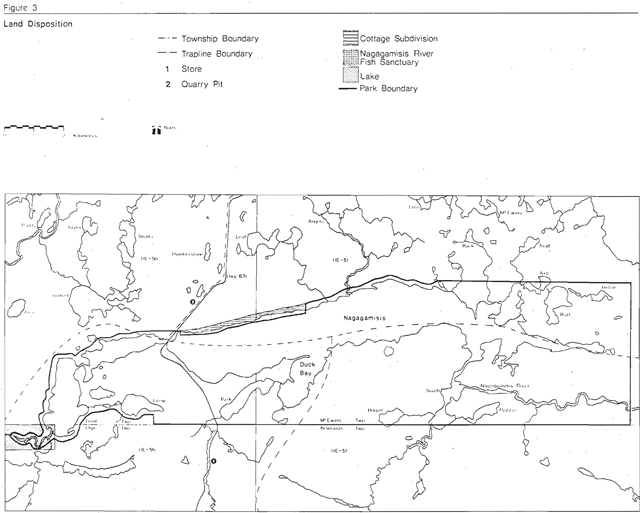
Nagagamisis Provincial Park was officially established by Order-InCouncil in 1957. It then consisted of 1,530 ha at the west end of Nagagamisis Lake and included the area now occupied by a cottage subdivision (Figure 3). At that time, a 3,160 ha historical reserve, declared in 1956, also abutted the lake, at the east end. In 1958, the park boundaries were revised, reducing the size of the park by eliminating land on the north shore of Nagagamisis Lake as well as part of the lake area. However, the increase in visitation resulting from the completion of Highway 631 to Hornepayne prompted an enlargement of the park in 1963 to include the historical reserve and the area between the reserve and the original park. The total park area after expansion was 4,810 ha.
In 1970, the park boundary was extended 400 m out into Nagagamisis Lake to allow for better shoreline control. This extension increased the park’s area by 1,040 ha to 5,850 ha.
In 1976 an additional 2,281 ha including all of Nagagamisis Lake was proposed as an addition to the park. This addition was finalized in 1978 and brought the total area of the park to 8,131 ha.
Nagagamisis was officially designated a Natural Environment Park in 1970 under the 1967 Ontario Parks Classification System and is registered by Ontario Regulation Sl7/78.
Figure 3: Land disposition
Enlarge figure 3: Land disposition (PDF)
4.2 Mining
The only mining activity within the park boundaries has been the extraction of sand and gravel from the Arnott Lake kame moraine deposits by the Ministry of Natural Resources and the Ministry of Transportation and Communications. This activity has taken place at 3 pits totaling 4 ha adjacent to Highway 631.
In 1975, use of the material was discontinued and the pits are presently being rehabilitated by the Ministry of Natural Resources.
4.3 Forest operations
No cutting has ever occurred in the park although the area has been under licence in the past. In 1943, Marathon Paper Mills of Canada Limited (later Marathon Corporation of Canada Ltd.) entered into an agreement with the Crown for the Naagami Concession, within which the park is located. This agreement came into effect in 1944 but a cruise (in-field evaluation of timber resources) was not undertaken until 1947 and the area was not mapped until 1948. In 1964, Marathon performed an inventory based on 1961 aerial photography and the 1946 cruise figures.
In 1967, the corporation was taken over by American Can of Canada Limited who cruised the area again in 1974. The park has since been deleted from American Can’s licence and is presently contained in the Pitopiko Crown Management Unit.
4.4 Fire history
The primary historical disturbance of the park’s timber has been fire. It is evident from the existence of the extensive mature stands of relatively even age that most of the park was burned over within a short (10 years or less) period of time by one large fire or several small fires (Perraton, 1973). Large fires are known to have burned over the area north of Hornepayne during and after the building of the railway, and it is likely that most of the present stands in the park date from that period. A large fire is also known to have occurred in the area about 1922, and this may have included the southern portion of the park.
4.5 Wildlife management
Four registered traplines (HE-50, HE-51, HE-56, HE-57) overlap the park area (Figure 3). Beaver is the principal fur-bearing species harvested on these lines from an economic standpoint. During the 1977-78 season, 219 beaver were obtained from the 4 lines. (The park constitutes a very small proportion of the total area of each licence.) Recent aerial surveys of active beaver colonies have indicated an annual quota of 204 beaver for the 4 traplines.
Other species trapped in significant numbers in 1977-78 included marten (130), muskrat (27), otter (22) and mink (12).
Since the park was established in 1957, hunting has been an off-season use. This water accessed hunting occurs mainly in the area most recently added to the park.
4.6 Fisheries management
Nagagamisis Lake contains an important District pickerel fishery. On the average, Nagagamisis Lake yields a high annual harvest of fish per year. The most prominent species caught is yellow pickerel followed by northern pike, yellow perch and lake whitefish. Creel census data from 1976 showed that between May 10 and August 31, 3,636 fish were caught (yellow pickerel, northern pike, yellow perch) over 22,878 hours.
In 1974, a 325 ha fish sanctuary was established at the west end of Nagagamisis Lake to protect a sensitive pickerel spawning area. In conjunction with the creel census, fish tagging programs were undertaken in 1975 and 1976.
4.7 Winter recreation
Because of its distance from major population centres winter use of Nagagamisis is very low, although the occasional visitor does come to ice fish, snowmobile and cross-country ski.
4.8 Visitor services
Since 1974, a seasonal park naturalist has carried out a visitor services program. Activities included: conducted walks, canoe hikes, campfire programs and campsite visitation. In 1979, all park trails and programs were being converted to self-use.
4.9 Park development
Camping, day-use and other support facilities are located on the east side of Highway 631 south of Nagagamisis Lake (Figure 4). All park facilities are listed in Table 3.
The park also provides canoe access to Nagagami and Shekak rivers, two important district canoe routes. Canoeing possibilities within the park are confined to Nagagamisis, Park and South lakes. Four canoe route loops of 8, 12, 13, 17 km long are also located in this area.
One walking trail and 2 nature trails totaling 5 km are found within the park. Both the park and the Nagagamisis Uplands directly north of the park, display good potential for hiking trail development.
During spring, winter and fall, Nagagamisis provides a variety of activities to both local and non-local visitors.
Figure 4: Park development

Enlarge figure 4: Park development (PDF)
| Facility | Quantity |
|---|---|
| Comfort Station (Type 8) | 1 |
| Vault Privies | 20 |
| Change Houses | 2 |
| Fish Cleaning Shelter | 1 |
| Boat Launch Ramps | 1 |
| Trailer Sanitary Station | 1 |
| Pressurized Water System | 1 |
| Wells | 1 |
| Trailer Filling Station | 1 |
| Trailer Pull Throughs | 48 |
| Tent and Trailer | 117 |
| Swimming Beaches Camper Beach dry |
410 m2 |
| Swimming Beaches Camper Beach wet |
819 m2 |
| Day-use Beach dry | 1 ,464 m2 |
| Day-use Beach wet | 2,928 m2 |
| Picnic Area | 115 ha |
| Parking Lot | 8 (120 car capacity) |
| Trails Interpretive (nature) | .8 km |
| Trails Hiking | 2.4 km |
| Park Office | 1 |
| Summer Staff Quarters | 1 |
| Maintenance Building (small) | 1 |
| Pump House | 1 |
| Diesel Generator Power House | 1 |
| Number of Generators | 2 |
| Underground Hydro Line | 1.6 km |
| Water Lines | 4.7 km |
| Garbage Dumps | 1 |
| Sewage Disposal Area | 1 |
| Boathouse | 1 |
| Gas Shed | 1 |
Camper origin statistics for 1974 indicate that over half of the camping visitors to Nagagamisis are Ontario residents (32 percent from Northern Ontario, 20 percent from Southern Ontario) while approximately 46 percent come from the United States. Only about l percent of campers originate in other provinces. The park serves two distinct types of visitors, the local weekend camper and the more distant vacation camper. Another small but important component is the use of the park by construction and bush workers while temporarily employed in the area.
Day-use: Day-use statistics for the past 2 years show a relatively low level of use compared to camping. Only 1,340 and 1,307 user-days were consumed in 1978 and 1979 respectively. This may be a reflection of the fact that there tends to be a fair amount of unmonitored use by travellers who park on Highway 631 and enter the day-use area directly, without passing through the park gates.
Senior citizens: In 1979, 26 senior citizens utilized the day-use facilities at Nagagamisis, a decrease of l over 1978. The number of campers decreased from 122 to 94 from 1978 to 1979.
Spring and fall use: During spring and fall, hunters and fishermen stay in the park while hunting in areas adjacent to the park and whil e fishing both within and adjacent to the park. During the winter months, the park is open for snowmobiling, ice fishing, cross-country skiing and snowshoeing.
4.10 Facility capacity
Nagagamisis Provincial Park provides the only source of intensive recreation opportunities along Highway 631. With 165 campsites, Nagagamisis has the capability to annually provide 33,650 camper-days. Day-use facilities can accommodate 4,929 user-days annually.
Traditionally, the heaviest use of campsite and day-use occurs during July and August. The July-August camper-day potential for Nagagamisis is 20,255 camper-days, the existing beach potential is 2,356 user-days and the picnic area 2,292 user-days. Because the picnic area is located adjacent to the beach area and because it can be assumed that 60 percent of all picnickers will use the beach, then only one capacity was calculated for the total day-use area. This was calculated to be 3,273 user-days for July and August (Table 4).
Motorboating along the 14 km of Nagagamisis Lake and the 6.4 km of Nagagamisis River which is situated within the park has good potential to provide extensive recreation opportunities. Generally, motorboating results from fishing excursions to the eastern mouth of the Nagagamisis River.
4.11 Park use
Camping: Statistics indicate that the majority of park users are campers. Since 1970, the number of camper-days consumed annually has exceeded 10,000 and increased to 16,475 in 1973. After the number of developed campsites was increased from 83 to 165 in 1974, camper-days consumed increased to 20,716 in 1976 and then decreased to 11,481 in 1979. The decrease in camper-days from 1976 to 1979 can be attributed to several factors, mainly weather. Table 5 lists park visitation (camping) statistics for Nagagamisis Provincial Park for the last 13 years of operation.
| Facility type | Existing Development | User-Day Potential (July/Aug.) | User-Day Consumption (July/Aug.) | Surplus of Deficit of User-Days |
|---|---|---|---|---|
| Campground | 165 campsites | 20,255 | 8,406 | + 11 ,849 |
| Picnic Area | 1.5 ha | |||
| Day-Use Beach | 1,464 m2 (dry) 2,928 m2 (wet) | 3,273 | 785 | + 2,488 |
| Nature Trail | 4.4 km | 3,410 | 250 | + 3,160 |
| Year | Developed Campsites | Number of Campers | Average Length of Stay | Camper-Days | July/August Occupancy |
|---|---|---|---|---|---|
| 1979 | 165 | 4,577 | 2.5 | 11 ,481 | 26 |
| 1978 | 165 | 6,155 | 2.0 | 12,533 | 28 |
| 1977 | 165 | 5,823 | 2.9 | 16,906 | 38 |
| 1976 | 165 | 6,253 | 3.3 | 20,716 | 44 |
| 1975 | 165 | 6,152 | 3.1 | 18,913 | 40 |
| 1974 | 165 | 7,643 | 2.4 | 18,470 | 38 |
| 1973 | 83 | 6,492 | 2.5 | 16,475 | 64 |
| 1972 | 83 | 3,912 | 3.4 | 13,336 | 55 |
| 1971 | 83 | 4,529 | 3.7 | 16,768 | 69 |
| 1970 | 83 | 3,925 | 3.7 | 16,428 | 58 |
| 1969 | 83 | 2,252 | 4.1 | 9,252 | 41 |
| 1968 | 83 | 2,591 | 2.6 | 6,677 | 48 |
| 1967 | 83 | 2,457 | 4.0 | 9.713 | 48 |
5.0 Biophysical resources
5.1 Climate
Climate is generally regarded as an influencing factor on recreational activities and visitor statistics often reflect this fact. In Northern Ontario, particularly during May and September when weather conditions are particularly unpredictable, park visitation figures show great variability. Weather conditions not only affect the rate of participation in outdoor activities but also influence the degree of participant satisfaction that can be obtained.
The average last spring and first autumn frosts occur on June 15 and September 2 respectively, giving an average of 80 frost-free days per year. Lakes and rivers are generally frozen over from mid-November to mid-May.The mean annual daily temperature for the area is 0°C while average daily temperatures for selected months are as follows: January: -19°C, April; -10°C, July; 17°C, October: 40°C.
Mean annual precipitation (rain plus rain-equivalent of snow) is 76 cm, half of which occurs from the beginning of May to the end of September. Average annual snowfall for the area is 292 cm.
In general, Northern Ontario is influenced by several air masses including moist sub-tropical, and dry arctic and continental. As a result, extreme and rapid changes in weather often occur. However, the variability and relatively cool average daily summer temperatures are offset by long hours of daylight and low humidity.
5.2 Geology and geomorphology
Nagagamisis Provincial Park is situated within the Quetico metasedimentary belt of the Canadian Shield’s Superior structural province (Ayres, et al., 1970). In the park, the bedrock consists of ancient sedimentary rocks which have been intruded and deformed by granitic igneous rocks (Davidson, 1973). This bedrock was formed over 2.5 billion years ago in the Early Precambrian Era.
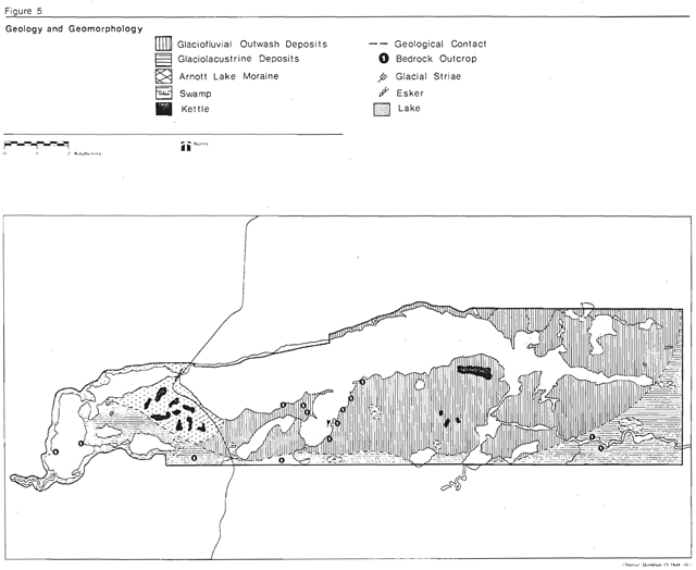
The landforms of the park are a product of the Precambrian bedrock, Pleistocene glaciation and Recent geomorphic processes. The erosional action of the advancing glacier is recorded in striae (scratches) and whale backs (streamlined hills) along the east shore of Duck Bay (Figure 5). The depositional action of the receding glacier is recorded by the Arnott lake moraine east of Highway 631. This moraine is comprised of stratified sand deposited during the Nakina phase of glaciation (approximately 9,000 years ago). The Arnott lake moraine has been correlated with similar features near the White Otter River in the west and Fraserdale in the east (Boissoneau, 1966).
The glacier’s margin and the Arnott lake moraine in the north and the Height of Land in the south acted as boundaries for glacial Lake Barlow-Ojibway. Meltwaters from the glacier deposited sands, silts and clays into this lake. Glaciolacustrine sediments can be observed in the eastern portion of the park. The erosional action of meltwaters along the margin of the glacier likely formed the trough in which Nagagamisis Lake is presently located. The northward retreat of the glacier was followed by a readvance during the Cochrane phase of glaciation (approximately 8,200 years ago). During this phase, material from the
Figure 5: Geology and geomorphology
Enlarge figure 5: Geology and geomorphology (PDF)
Arnott lake moraine and Lake Barlow-Ojibway were incorporated into the glacier. The resulting sandy till was deposited over top of the Arnott lake moraine. This till may be observed in the sand and gravel pits west of Highway 631.
Recent geomorphic processes are evident along the south shore of Nagagamisis Lake. The erosional action of waves and currents have created a bluff between the picnic area and the main dock. Sand eroded from the bluff has been transported easterly and deposited in the relatively calm water at the mouth of Duck Bay. The accumulation of these deposits has created a recurved sand spit. The long narrow spit which terminates with a small island resembles a tombolo (Figure 5). The accumulation of sand at the end of the bar provides an environment in which gastropods and molluscs are being buried and in time fossilized.
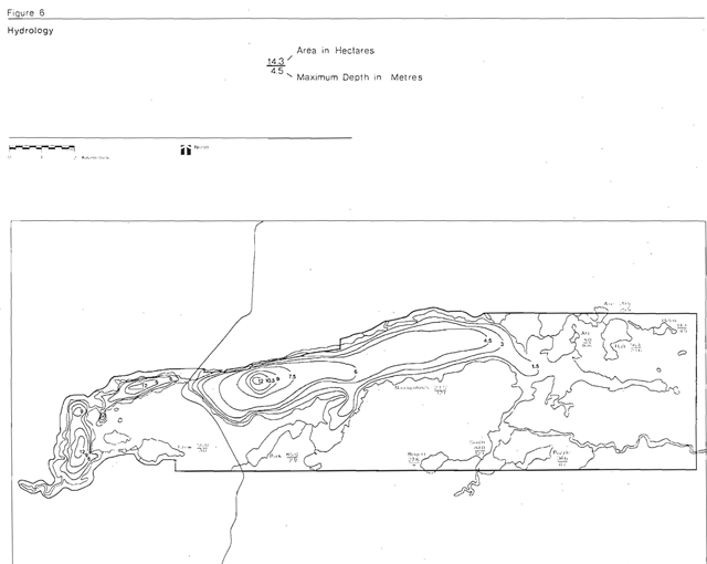
5.3 Hydrology
Nagagamisis Lake is the major water body within the park, occupying 2,330 ha of the park’s 7,542 ha. A number of smaller lakes within and outside the park boundaries feed Nagagamisis Lake (Figure 6). The lake and connecting stream system drains into James Bay via the Albany River Basin.
Data from lake surveys (Table 6) show that the lakes have a pH range of 7.7 to 8.5 which indicates the presence of calcareous (alkaline) materials. All the lakes host warm water fisheries.
Figure 6: Hydrology
Enlarge figure 6: Hydrology (PDF)
| Lake Name | Area | Depth (m) Mean | Depth (m) Max. | 0 *2 distr (ppm) | Secchi Disc (m) | pH |
|---|---|---|---|---|---|---|
| Axe | 21.0 | 8.5 | 23.8 | 7.2 | 4.7 | 8 .5 |
| Bogart | 27.6 | - | - | - | - | - |
| Crew | 56.0 | 0.9 | 3.0 | 7.6 | - | 9.0 |
| Helen | 14.3 | 1. 4 | 4.5 | 8.6 | - | 8.0 |
| Jog | 5.0 | 4.9 | 16.6 | 8.0 | - | 8.0 |
| Nagagamisis | 2330.0 | 3.8 | 12.2 | 6.0 | - | 7.7 |
| Park | 65.0 | 2.9 | 4. 6 | 7.6 | 3.7 | - |
| Puzzle | 36.6 | 1. 7 | 6.7 | 9.6 | - | 7.5 |
| Raft | 23.8 | 9.0 | 4.9 | 8.5 | ||
| South | 84.0 | 4.3 | 12.2 | 8.0 | 2.4 | 8.2 |
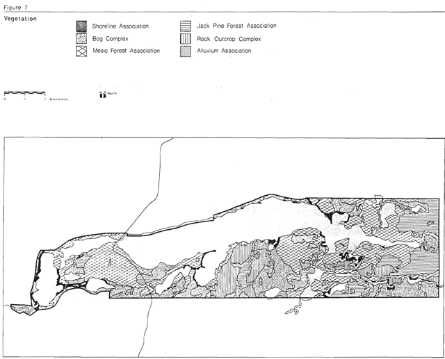
5.4 Vegetation
Nagagamisis Provincial Park is situated within the Central Plateau Section of the Boreal Forest Region (Rowe, 1959). The park lies on the southern edge of the Arnott Lake Interlobate Kame Moraine and is dominated by sandy glacial outwash deposits. Well-drained sites with podzolic soils are widespread and are marked by stands of jack pine, mixed stands and deciduous forests of white birch and trembling aspen. Large areas of rock outcrop also occur and are characterized by jack pine – spruce barrens. Much of the park has a generally undulating topography and peaty soils formed on the lowlands in the southeast section of the park are dominated by black spruce forests. Kettle-like depressions on the extensive sand plains may contain peat, which support bog or less commonly, fen communities (Perraton, 1973).
The flora of the park is primarily of boreal affinity. Affinities with the more southern site regions are also evident, particularly white elm and black ash communities. The extensive areas of deciduous woods, which support well-developed and diverse herbaceous flora and the extensive jack pine forests on the sand plain are more in keeping with the Great Lakes - St. Lawrence Forest than with the Boreal Forest.
Having been completely burned over in a relatively short period of time during the early part of the century, Nagagamisis is covered by mature stands of even-aged stands. This has resulted in a relatively simple pattern of vegetation within the park (Figure 7).
Figure 7: Vegetation
Enlarge figure 7: Vegetation (PDF)
5.5 Fauna
The general character of the terrain and vegetation of the park area has a considerable influence on the distribution of fauna within and outside the park. Dominated by either dry, open mature woods or by boggy, mature coniferous forest, the area has only local patches of shrub undergrowth. Animals which rely on twigs and shrubs for their diet are therefore not favoured. Recent wildlife surveys (January, 1975) have indicated a relatively low moose density for the park area (0.09/km2), although it is presumed to be somewhat higher within the park boundaries. Snowshoe hares, spruce hens and ruffed grouse are common although this may be due to their cyclic nature, in that their numbers tend to rise and fall, generally over a 10-year period.
The area of wetlands in the park is also very limited. .Beaver is locally distributed over the ponds and water courses surrounding Nagagamisis Lake and muskrats are restricted to the few marshes in the southeast portion of the park. Mink and otter can be found in the area as well.
Waterfowl are present in relatively limited numbers around the marshy shores in the east-central part of the park. Mallard and black ducks are the most common species. Birds, such as the great blue heron nest in shallow marshes in the more secluded reaches of the park. Since a large proportion of the existing wetland is shrubby in nature, the already restricted carrying capacity for waterfowl is further reduced.
Species preferring dry, open or boggy, mature coniferous woods are well represented in the park. Red squirrels, flying squirrels and eastern chipmunks are common and the pine marten is likely present. Black bears have been sighted and are likely attracted to the park by the bountiful berry crop in some sections.
The most numerous birds in the area are those breeding in mature, boggy coniferous forests, a habitat widespread in the southern part of the park. The yellow-bellied flycatcher, olive-backed thrush, rubycrowned kinglet and myrtle warbler are typical of this group.
In the dry mature woods, woodpeckers, particularly flickers, are common. Species such as the chestnut-sided nashville and magnolia warblers which require slash, heavy undergrowth, edge habitats, or young trees are rare. Occasional veerys and red-eyed vireos have been sighted in the aspen forests and the ovenbird in the birch forest in the northwest sector of the park.
Nagagamisis is located on the Mississipi flyway and partially on the Atlantic flyway. In this regard, it has been suggested (Perraton, 1973) that the park area is an important nesting and staging area for song birds during spring and fall migration.
The parks northern location greatly restricts the variety of amphibians and reptiles. The Hudson Bay toad is common through the moist or boggy woods and the boreal chorus frog is plentiful in the marshes. The only reptile likely present in the park is the eastern garter snake.
6.0 Cultural resources
Ontario’s past is divided in 5 distinct cultural periods or eras: the Paleo-Indian, the Archaic, the Middle Woodland, the Late Woodland and the Historic. In Nagagamisis Provincial Park, evidence of only the Late Woodland and Historic eras have been found.
An archaeological survey and an historic sites inventory of Nagagamisis Provincial Park (Pollock, 1973; Pendergest, 1973) identified 15 sites of interest, 5 prehistoric and 10 historic. Those considered to have high regional significance included 2 prehistoric and 8 historic sites while only one prehistoric site was considered to be highly significant provincially. None of the sites was regarded as nationally significant.
The various cultures that are presumed to have occupied the park area are:
| Time Period: | Era | Aboriginal Culture |
|---|---|---|
| 800-1650 A.D. | Late Woodland | Algonkian (Cree ?) |
| 1650-1900 A.D. | Historic | Algonkian (Cree ?) |
| 1900-1930 A.D. | Late Historic | Algonkian (Ojibway-Cree) |
6.1 Prehistory
Archaeological work has indicated that Nagagamisis was utilized, possibly on a seasonal basis, by small nomadic bands of Algonkianspeaking people, likely Cree, living a subsistence lifestyle of hunting and gathering. Among artifacts recovered within the park are flakes, bone fragments, body sherds, stone wedges, biface blades, scrapers, abraders, stone drill and trade beads (Pollock, 1973). The presence of flint scrapers and stone drills indicates the preparation and use of clothing made from animal hides. On the other hand, the absence of flint arrow heads (used for big game hunting) implies a relatively heavy reliance on fish and small game. Many fish bones have been recovered and the use of willow bark nets (used before twine was available) is probable. Food was apparently cooked in pottery vessels and moose paunch kettles and utensils were likely made of bone and wood.
Analysis of animal bones discovered in the park (Burns, 1973) suggested that the inhabitants were very dependent on the beaver population. Remains of caribou and related species have also been found but are less common. Also of interest is the discovery of wolverine bones, the first at an archaeological site in Ontario. Other species identified by bone analysis include snowshoe hare, muskrat, woodchuck, marten, otter, black bear, Canada goose, red-throated loon, ducks, northern pike, pickerel and sucker.
6.2 History
Research has indicated that, except for the activities of one or two white trapper/ traders for a short period of time, the main component of human history in the area was the presence of 4 Indian (Cree and Ojibway) families on the shores of Nagagamisis Lake. This group occupied the area in the early 1900s and although they resettled on Morrison River in the 1930s, Nagagamisis Lake continued as a winter campsite.
With the development of the Canadian National Railway in the early 1900s came the developn nt of Hornepayne as a divisional centre for railroad activities. The period during and after World War II brought a decline in isolation to the Nagagamisis area. The new focus of economic and community activity eventually drew many of the indigenous people out of the bush and away from their primitive lifestyle.
During the past 40 years, there has been a transformation in lifestyle of the local Indians from a subsistence economy of fishing, hunting and trapping to one based on employment by lumber companies, Ontario government ministries, et cetera.
The physical constraints of the area limited human occupation and activity. Historical remains illustrate this fact. Most of the historic sites within the park boundaries are not very unique to the Nagagamisis area and therefore represent its general historical character.
Field surveys by Pendergest (1973) noted the remains of several Indian campsites around the shores of Nagagamisis Lake. There are also two sites where Indian graves are located. These graves are characteristics of the area and are directly connected with Indian families who occupied the Nagagamisis area, the Morrison River Settlement and who presently form a large percentage of the Indian community at Hornepayne. One other site r cords a white trapper/ trader living in an Indian dominated area. Most sites relate to the history of the indigenous peoples v1hile the fur trade is a secondary theme. Mining, forestry and agriculture are not relevant themes to the area.
7.0 Enviromental analysis
The administrative policies for the Ontario Provincial Parks System identify the need to protect significant and representative natural landscapes of the province. Nature reserve parks and zones are intended to contain original plant and animal species native to Ontario, geological or geomorphological features representative of a specific period in the province’s geological history, features of scientific or interpretive value or benchmark areas against which environmental change can be measured. Nagagamisis Provincial Park contains candidates in all three of these categories.
Sensitive and significant features are the important parameters determining the degree of development to which a park should be developed. For Nagagamisis, an optimum level of development based on recreational quality standards and environmental constraints has been determined beyond which it may not be advisable to develop.
7.1 Sensitive features
Water quality: Nagagamisis Lake suffers from water contamination from a variety of sources. Outboard motors are a major contributor since there are no restrictions on the size or number of motors all owed on the lake.
The other lakes located within the park boundaries are relatively pollution-free. They are, however, susceptible to the effects of outboard motors and litter disposal due to their small size. Park Lake is closely monitored since it supplies drinking water to the campgrounds.
Vegetation: There are a number of environmentally sensitive vegetation complexes within the park which require protection.
The extensive complex of dry soil communities on the Arnott moraine system is sensitive due to its unstable habitat. The chain of bogs along the southern boundary of the park and in the extension area are also quite sensitive to the effects of heavy use and to abrupt changes in drainage. These bogs contain many fragile plant communities. A further biologically sensitive area is the white elm stand on the sand spit in the northeast section of the park. The stand has been identified as provincially significant and any degradation of its quality due to abuse should be prevented.
Duck Bay and the east end of Nagagamisis Lake are both important feeding areas for migrant birds and as such should be protected from changes in water levels.
Geological and geomorphological features: The tombolo bar at the mouth of Duck Bay is moderately fragile due to its limited area and sparse vegetation cover. Extensive use of the bar as a recreation area could eliminate vegetation and result in extensive erosion by wave and current action.
The kame moraine system, although already affected by sand and gravel extraction, is a valuable indicator of glaciation in Northern Ontario and should be protected from further utilization.
Archaeological features: All of the archaeological and historical features inventoried are sensitive to abuse by park visitors and must be protected.
7.2 Significant floral features
The representation of life science features, as outlined in the Ontario Provincial Parks Planning and Management Policies is based on the distribution and description of broad vegetative habitats within each of the province’s 13 site regions as described by G.A. Hills (1966). Within each site region different combinations of substrate, soil moisture regime and micro-climatic produce distinctive environments for vegetation development. Maycock (1976) has combined these site parameters in a matrix to outline 150 theoretical environments within a site region. Nagagamisis is located in Site Region 3E and has significant provincial representation for at least two of the possible 150 vegetation communities in Site Region 3E (Figure 8). The park area also has a number of significant regionally and locally representative sites. Only provincially and high-regionally significant features are considered as candidate nature reserves.
Black-ash and white elm stand: This area is considered provincially significant (Perraton, 1973). The stand itself is representative of the development of black ash on particular microsites and as such has some interpretive value. Physical damage could easily destroy the white elm stand since individual trees are few in number. Compaction of the soil through heavy visitor use might prevent regeneration of the stand (Figure 9). This is a candidate nature reserve.
Chain of bogs: This site is of high regional significance. In addition, it is exceptionally rich in orchids and is the only place in the park where the yellow lady’s slipper and the round-leaved orchids were observed. In addition, the presence of the plant, gaywings tends to increase the value of this site. It has moderate interpretive val ue as an exarnple of infilling of a depression by peat. This bog is a very high quality of its type (Figure 9). This is a candidate nature reserve.
| Substrate and temperature category | Mosture Reg. arid |
Mosture Reg. very dry |
Mosture Reg. dry |
Mosture Reg. |
Mosture Reg. mesic |
Mosture Reg. wet mesic |
Mosture Reg. wet |
Mosture Reg. very wet |
Mosture Reg. saturated |
Mosture Reg. open water |
|---|---|---|---|---|---|---|---|---|---|---|
| Colder Rock |
||||||||||
| Colder Sand |
Some Representation of Site Region 3E | |||||||||
| Colder Loam |
||||||||||
| Colder Clay |
||||||||||
| Colder Organic |
||||||||||
| Normal Rock |
Some representation of site region 3E | Some representation of site region 3E | ||||||||
| Normal Sand |
Some representation of site region 3E | |||||||||
| Normal Loam |
||||||||||
| Normal Clay |
||||||||||
| Normal Organic |
Chain of bogs Significant Representation of Site Region 3E |
|||||||||
| Warmer Rock |
||||||||||
| Warmer Sand |
Some representation of site region 3E | |||||||||
| Warmer Loam |
||||||||||
| Warmer Clay |
Black Ash/White Elm Significant Representation of Site Region 3E |
|||||||||
| Warmer Organic |
Source: Maycock matrix
Figure 9: Natural areas
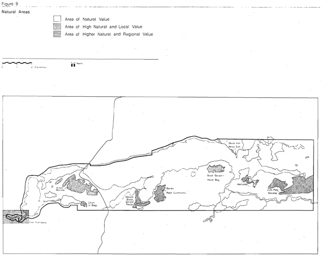
Enlarge figure 9: Natural areas (PDF)
Jack pine barrens: Regionally, this site has a certain degree of uniqueness since its location on a sand moraine has produced communities adapted to exceptionally droughty soils on a larger scale than one is likely to find easily elsewhere (Figure 9). It might in fact be difficult to find as extensive a complex of dry soil communities as exists on the Arnott toraine anywhere else within the Boreal Forest formation in the Province. It is very unlikely that another comparable complex exists within the Central Plateau Section.
Mature black spruce forest: This site has a floor of schreber’s moss and is very representative of the lowland forest of the park and of the surrounding region. It is an excellent example of a community which probably typifies the Boreal Forest more than any other single feature. Its interpretive value is considerable because of its purity and its climax position. This community is not particularly fragile under moderate use.
Barren rock community: East of Duck Bay is a representative barren rock community of substantial interpretive value as illustrated by the adaptation of the community to a lack of soil and moisture, the role of fire in extending the rock barrens down-slope and the fragility of the lichen mats which cover much of the rock surface. The area is large and movement is easy, however, damage caused by use should be minimized by careful management of the area.
Black spruce-heath bog: This area has excell ent interpreti ve potential as an example of the stages and succession of infilling of a depression by peat bog. The bog is locally unique in that it contains an exceptional abundance of cloudberry ground cover. The site is of very high quality, particularly the floating bog, a feature which is not common in the park. The latter feature is however, moderately fragile and any access points provided should be shifted from time to time to prevent local destruction.
Wetlands: This site is the most extensive area of well-developed wetlands in the area. It is not particularly unique, its value lies in its representativeness as a typical shoreline complex illustrating the relationship of the three major shore communities - emergent herbaceous vegetation, emergent shrub thickets and larch-cedar-alder forest. It has interpretive value in explaining and illustrating stages of succession the infilling of a pond, lake or marsh by non-peaty vegetation, and the respective roles of herbaceous, shrubby and aboreal vegetation.
Fish sanctuary: In 1974, a fish sanctuary was established at the west end of Nagagamisis Lake in an effort to protect an important yellow pickerel spawning ground. Enforcement measures had proved inadequate against illegal snagging and over-exploitation during the vulnerable spring spawning period. Fishing is now prohibited in the area from April 15 to June 15 each year.
7.3 Significant geomorphological features
The nature reserve system for earth science features is based on the identification and preservation of representative features in each of the 37 geological regions (Stockwell, 1964; Dreimanus and Karrow, 1972) in the province which best represent the geological and geomorphological history of Ontario.
A number of significant geological and geomorphological features have been identified within and adjacent to the park boundaries. Outcrops of greywacke metasediments, felsic intrusions and diabase dykes occur at various locations within the park, primarily along the shorelines of Nagagamisis Lake and Duck Bay.
Glacially derived features are also prominent, both inside and outside the park. Striae on diabase dykes provide evidence of the erosional powers of the ice sheet while a variety of landforms illustrates the extent of glacial and outwash deposits. The Arnott moraine deposits are found in the western part of the park and along the north shore of Nagagamisis Lake, and are traversed by an esker west of Highway 631. Lacustrine sediments from glacial Lake Barlow-Ojibway occur in the southern and eastern portions of the park. A thin blanket of Cochrane Till covers the surface of the kame moraine in the parks north and west sectors. In the extreme western end of the park, an interesting association of lacustrine, glaciofluvial and morainic deposits occur within an area of 2 km2. Glacial features are also found outside the park boundaries. Kames, kettles, eskers, lacustrine deposits, ancient shorelines, striae and till are all evident to the north and northeast of the park.
The products of recent geomorphic processes are also evident within the park in the form of sand spits and shoreline bluffs.
Kame moraines: The significance of the glacial landforms is indicated by the fact that Nagagamisis Provincial Park is geographically located at the interface of three distinct glacial environments which resulted in the deposition of a kame moraine system in one area and a lacustrine plain in an adjacent area (Figure 9). Interlobate kame moraines are rare in Nort hern Ontario as are moraines overridden by glacial readvances. The Arnott moraine is an interlobate kame moraine deposited during the Nakina Phase and then overridden and modified by the readvance of ice during the Cochrane Phase of the Wisconsinan glacial stage.
The geological and geomorphological features are especially valuable in that they help to identify particular stages in the geological history of the area.
7.4 Environmental carrying capacity
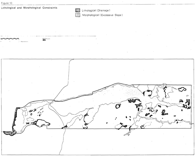
Optimum resource capacities must be identified for Nagagamisis which ensure protection of existing resource qualities and recreational experiences. Therefore, an optimum capacity must be identified for camping, day-use, interior use and lake use. Prior to establishing these capacities, sensitive and natural value areas must be separated from those areas displaying development potential.
Figure 10 identifies lithological and morphological constraints to development. Lithological constraints reflect soil conditions which are not favourable to development such as wet lowlying areas. Morphological constraints refer to landscape features which are not conducive to development. An example of this would be the kame moraine and the tombola spit.
With 165 campsites, Nagagamisis Lake can annually provide 33,650 camper-days, based on a 60 percent occupancy rate and a 103 day season. Traditionally, the months of July and August account for the heaviest use in Northern Ontario parks. A 60 percent campground occupancy is considered to be the limit for optimum use, taking into account environmental impact and user experience.
Figure 10: Lithological and morphological constraints
Enlarge figure 10: Lithological and morphological constraints (PDF)
Although there is the potential to provide a further 85 campsites within the present development area, this degree of development would have a serious effect on the pickerel fishery in Nagagamisis Lake. For this reason 200 sites have been set as the optimum level of campground development or 35 sites over and above the existing 165 sites. With 200 sites the park will be able to supply 40,788 camper-days annually.
The existing campground development is more than adequate to meet the present demand. Use by residents of the United States is expected either to stabilize or decrease slightly. The expansion of Fushimi Lake Provincial Park will absorb some of the demand from Hearst but the planned Canadian National Railway expansion in Hornepayne will focus an increasing demand from that direction.
Nagagamisis has an extensive, undeveloped day-use area. However, day-use has declined in recent years and this can be attributed to the development of Fushimi Lake Provincial Park close to Hearst. The town is planning additional facilities of its own, but with the expected increase in population of the Hornepayne area the overall day-use at Nagagamisis should at least remain stable in the future.
There are no developed extensive recreation facilities at the present time within the park. The park has a capacity for eighteen interior campsites. This will provide a maximum of 3,337 camper-days of opportunities during the summer. These sites will serve as overnight stopovers for canoeists and hikers but may also be used as destination campsites. An additional 2,700 user-days can be provided during the spring and fall by fishermen.
The park has 4.4 km of nature trails developed at the present time, providing 6,394 user-days of opportunity. In 1979, about 400 visitors used the three trails over the season. An additional 14 km of hiking is planned in conjunction with interior campsite development. This will provide 1,085 user-days of hiking opportunity.
8.0 Park policy
The park goal and objectives provide direction for protection, management and development of park resources.
8.1 Park goal
To provide high quality recreational and educational experiences within an outstanding natural environment setting.
8.2 Park objectives
Protection:
To protect provincially and regionally significant and representative earth and life science and cultural features.
To develop and initiate resource management plans which will specify optimum management procedures necessary to adequately protect the natural and cultural resources of the park.
Recreation:
To provide 47,998 destination camping opportunities for resident and non-resident users.
To annually provide 4,538 day-use opportunities while maintaining a high quality park experience.
To provide 3,337 and 1,085 interior camping and hiking opportunities respectively while preserving natural conditions in the park.
To construct facilities necessary to support the quality and quantity of recreation opportunities to be provided and to design these facilities in harmonious relationship with each other and with the character of the environment to be perpetuated.
Heritage appreciation:
To provide opportunities for unstructured exploration and appreciation of Nagagamisis’ natural landscape.
To provide park visitors with information about the park and other Ministry of Natural Resources programs.
To explain the rationale behind specific resource management strategies through the appropriate media, facilities and services.
Tourism:
To provide Ontario residents and non-resident visitors with opportunities to discover and appreciate a distinctive region of the province.
8.3 Park origin and name
The park is named after the lake it surrounds. Nagagamisis is a Cree word that means little sandy lake. This is the only name ever used for the lake and park.
8.4 Park classification
Natural environment parks which incorporate natural, cultural, and recreational features have formed a key element of the Provincial Parks system since its very beginning. Nagagamisis Provincial Park is classified as a natural environment park. The significance of its natural landscape merits the retention of this classification.
9.0 Management policies
The resources of the park will be managed with a view to maintaining the natural equilibrium which is considered desirable relative to the level of use and visitor experience to be provided. Careful consideration has been given to the protection of significant earth science and cultural historic landscapes.
9.1 Fish and wildlife management
Fishing:
The park fishery will be managed according to the fisheries management plan for the park. This plan will be reviewed every 5 years. The warm water fishery of Nagagamisis Lake is one of the most important in the district. It will be managed to provide high quality sport fishing opportunities for park users through careful monitoring of the resource and its habitat.
Hunting:
A decision to allow or not allow hunting will be made in March, 1981 based on forthcoming information. In the interim, hunting will be permitted in all areas of Nagagamisis Provincial Park except nature reserve and development zones. The March, 1981 decision will identify which areas will or will not be open to hunting and will be based upon the results from a 1980 park hunter survey and a 1979 master plan public participation program.
Trapping:
Trapping, by status Indians
- It will not be permitted in either the nature reserve zones or the development zone.
- It will not be permitted on developed park trail.
- Evidence of any trapping activities within the historic zones must be removed each spring.
- No new trapper’s cabins will be permitted.
- Existing trapline licences and cabins will be phased out of the park upon abandonment by status Indian trappers.
Management techniques:
Specific management techniques, such as pickerel tagging and creel censuswill be used in an effort to study and maintain a significant fishing resource within the park.
Aquatic resources:
Studies of the park’s aquatic communities will be undertaken to determine their importance to the fish and wildlife resources of the park. Habitat management may be undertaken for aesthetic, recreational and interpretive purposes in the development and natural environment zones.
Introduced species:
Non-native fish or wildlife species will not be introduced in the park.
Interpretation/education program:
The interpretive program will be used wherever desirable to explain to park visitors the rationale behind specific fish and wildlife techniques.
Wildlife viewing opportunities:
Wildlife viewing opportunities will be encouraged for park visitors. Wherever possible, suitable viewing areas will be identified.
9.2 Vegetation management
Management:
The park’s vegetative resources will be managed according to the vegetation management plan for the park. This plan will be reviewed every 5 years. The planting of native tree species will be carried out under a 5 year tree planting program to ensure the provision of adequate shade, campsite and use-area buffers and erosion and aesthetic control.
Harvesting:
Commercial forest operations will not be permitted.
Fire management:
Forest fires will be suppressed. However, the Hearst District Fire Plan will include provisions for prescribed burning of overmature and decadent areas in the nature reserve zones only if a fire does occur in these areas.
Pathogen spraying:
Intensive spraying inside the park will only be permitted in the event that the park is the primary source for a disease or insect which threatens timber resources outside the park, or where a major outbreak would create hazardous conditions inside the park. Selective spraying may be permitted in the deve1opment zone where an insect or disease becomes detrimental to the vegetative community.
Viewing areas:
Habitat management will be permitted to enhance
Interpretation/education program:
The interpretive program will be used wherever desirable to explain to park visitors the rationale behind specific vegetation management techniques.
9.3 Land management
Land disposition:
All lands within the park are now reserved from disposition under The Provincial Parks Act.
Utility corridors:
No new utility lines or rights-of-way may be developed except for those required for servicing the park. All future park utility lines will be installed underground.
Aggregates:
Surficial extraction of aggregate for either park or non-park purposes will not be permitted. The success of rehabilitating of the two pits within the park will be monitored and, if necessary, further seeding, fertilizing or planting will be undertaken.
9.4 Environmental quality
Herbicides:
Herbicides will not be used by park personnel. The Ministry of Transportation and Communications will be permitted to spray their highway corridor subject to the guidelines outlined in the directive to Ministry of Transportation and Communications 1977.
Waste disposal:
Ministry of Environment and Ministry of Health standards for waste disposal will apply within the park. When the present garbage dumpsite is filled, it will be closed and a new site located outside the park.
Water quality:
Water quality of lakes in accessible areas will be monitored to detect changes in chemical composition. During the operating season, tests for coliform levels in waters of Nagagamisis Lake adjacent to the development zone will be carried out as specified by Ministry of Natural Resources standards.
9.5 Visitor services
The visitor services program will be operated according to the Northern Region Parks System Visitor Services Plan. The plan will be reviewed every five years.
9.6 Other policies
Emergency plan:
This plan will be reviewed annually (Refer to Nagagamisis Park Management/Operating Plan).
Motorized vehicles:
Motor vehicles of all types will be regulated or restricted to areas and zones compatible with their use. No motor powered boats will be permitted on Park Lake except in emergency situations. Snowmobiles will be permitted, but restricted to park roads only in the development zone.
Safety and public health:
All relevant government standards relating to visitor safety and health will be observed.
10.0 Park zones
Zoning is a planning and management technique to delineate areas which require different management strategies to meet park system objectives. It is one very effective way to provide development and administrative control over areas designed to meet different protection and use objectives.
Zoning also provides a framework for management and enforcement. The tension between protection and use will be minimized and park management will be able to respond with a range of specific uses subject to appropriate management limitations.
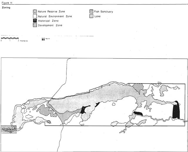
Four zones delineated for Nagagamisis are development, historical, nature reserve and natural environment (Figure 11).
10.1 Zone location and description
Development zone:
This is a 338 ha zone comprising the present campgrounds, day-use and support area facilities.
Day-use activities such as picnicking and swimming will be confined to designated areas. Campground services will include drinking water, central garbage pickup and a central woodyard. Group camping will be available to groups approved by the park superintendent. Staff quarters, maintenance and utility buildings will be located in this zone.
Figure 11: Zoning
Enlarge figure 11: Zoning (PDF)
Farest extraction which is aesthetically or therapeutically necessary and tree planting as required will be permitted. Trapping will not be allowed in this zone. The use of snowmobiles will be restricted to roads only, and outboard motors will not be permitted on Park Lake.
Historical zone:
Approximately 425 ha comprising 4 separate areas, have been designated as historical zones. Historical zones will provide laboratories for archaeological or historical research, educational and interpretive programs and cultural activities related to the history of the area.
Nagagamisis Provincial Park has a rich prehistory and subsequent history of indigenous peoples. Fifteen prehistoric and historic sites have been located within the park boundaries. Five of these are of prehistoric Algonkian cultural affiliation. The designated historical zones take in the 12 most significant sites as described and recommended for protection by Pollock (1973).
Within this zone no forest extraction Will be allowed. Evidence of any trapping activity must be removed each spring. Compatible recreation uses include viewing and photography. No camping of any kind will be permitted. The major emphasis will be on protecting these sites for interpretive, educational and research purposes. As part of the visitor services plan, a comprehensive program for site protection and interpretation through exhibit panel and publications will be developed.
Nature reserve zone:
Approximately 550 ha comprising three separate areas has been designated as nature reserve zones. These zones are designed to protect regionally and provincially significant geological and botanical features found in the park.
Within the nature reserves no forest extraction or aggregate removal will be allowed. Trap ping will not be permitted. Compatible recreation uses include hiking, viewing and photography. Access will be by either water or hiking trail. Non-destructive nature interpretation and scientific research will be encouraged.
Natural environment zone:
The remaining 6,229 ha of Nagagamisis has been designated as a natural environment zone. This zone provides good opportunities for extensive backcountry travel, canoeing and hiking.
Within the natural environment zone a number of areas, not of nature reserve quality, require more careful attention to minimize disturbance. Periodic monitoring will aid in following the changing state of these areas.
Forest extraction will not be allowed except for aesthetic or therapeutic reasons. Recreation activities permitted include hiking, canoeing, interior camping, fishing, vielwing, photography, cross-country skiing and snowmobiling. Snowmobile use is mainly by trappers and local residents and is confined by access generally to Nagagamisis Lake and the park roads.
11.0 Visitor/resource relationship
11.1 Visitor services
The visitor services goal for Nagagamisis Provincial Park is to aid its visitors in obtaining optimum enjoyment and benefit from the park, consistent with and complimentary to the park objectives.
The visitor services program at Nagagamisis will emphasize communication and interpretation. The program’s level of service will be at the basic or self-use standard. The existing self-guiding Time Trail
and hiking trail, together with proposed exhibits to develop the park’s major theme (aboriginal peoples), will be used in conjunction with the park leaflet to provide information and an interpretation of the park story. (The park leaflet will be revised during fiscal year 1979-1980).
Of recreational importance is the Nagagami River canoe route which begins in the park. Good speckled trout fishing is found in the Nagagami, Foch, Osawin and Shekak rivers as well as a number of small lakes off Highway 631 north of the park. Nagagamisis Lake provides good yellow pickerel and northern pike fishing.
Interpretation:
The interpretive component of the visitor services program will attempt to tell the park’s story to visitors. The major story or theme for Nagagamisis as identified in the Northern Region Parks System Visitor Services Plan is the park’s settlement over the centuries by aboriginal peoples. This theme will be developed using such devices and facilities as publications, exhibits and selfguiding trails. The differences and similarities between the themes at Nagagamisis and Missinaibi provincial parks should be explored.
Communication:
The communication component at Nagagamisis will be provided as required by all park staff - particularly those on gate duty. They will inform visitors of services and facilities at the park and in the surrounding area. They will utilize such media devices and facilities as publications ahd exhibits.
Recreation:
The recreation component of the program will assist visitors in taking advantage of the park and surrounding region1 S recreation opportunities. These include camping, swlimming, boating, fishing,
hiking and canoe tripping. Quite simply, the objective will be to provide the best, current information possible about these activities as required.
Outdoor education:
Direction for this component must be consistent with provincial policies which are not firm as yet. Nagagamisis Provincial Park should provide a basic level of service: this is to allow outdoor education groups the use of park resources (consistent with park rules and regulations).
Head Office has recently (September, 1977) provided some good interim direction in A Provincial Visitor Services System
(Ministry of Natural Resources, page 15).
All parks will provide information to teachers as an aid to their use of the park for school field trips. This will usually involve little more than the loan of resource reports related to the park and personal, informal advice…
Parks will generally leave the conducting of classes or tours to the teachers…
12.0 Development
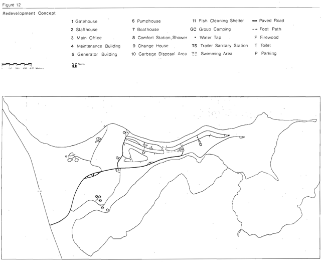
Three development concepts were evaluated for Nagagamisis. The recommended concept is outlined below. (Figure 12)
12.1 Development
Camping:
Once the optimum use of existing facilities has been reached, an additional loop will be added to Shaganash campground. Fifteen sites in the existing campground will be phased out and 50 new sites will be developed. This will bring the total campground development in the park to the desired maximum of 200 sites and will provide a total of 40,788 camperdays of opportunity. Additional support facilities will include a comfort station and an extended water system.
Two group camping areas will also provide an additional 7,210 camper-day opportunities based on a 100 percent occupancy rate, a 103 day season and 35 persons per area. The July-August group camping opportunities would provide 4,340 camper-days.
Day-use:
Present day-use facilities are located adjacent to Highway 631 approximately 4 km from the main park area. This area has suffered problems of unauthorized use from the highway as well as created inconvenience for park users and maintenance staff because of its distance. To alleviate these problems, the area will be phased out and a new day-use area developed west of the present boat launch.
Figure 12: Redevelopment concept
Enlarge figure 12: Redevelopment concept (PDF)
Because the major emphasis for Nagagamisis Lake is on low intensity recreation use and because large increases in total day-use is not expected, the capacity for the new area will only be modestly greater than that of the present area. Facility development will include :5 km of access road, a 60 car parking area, 2 change houses, 2 vault toilets, drinking water, 2,977 m2 of swimming beach (dry beach) and 1.1 ha of picnic area.
The daily capacity for the picnic area will be 28 users, the dry beach, 62 users. At any one time it is assumed that 60 percent of all picnickers will use the beach. Therefore, 73 people have been set as the optimum daily carrying capacity for the total day-use area or 4,538 user-days for July-August. The number of tables in the picnic area should not exceed 11. It is considered that this will be adequate to meet the expected demand.
Spring fishermen and hunters annually consume 175 user-days, fall fishermen and hunters consume 300 user-days and only about 50 user-days are consumed during the winter. This minimal winter use is not expected to increase as no facility or program development is planned.
Extensive recreation facilities:
The development of extensive recreation facilities will expand the available recreational experiences for park visitors. Eighteen interior campsites will provide 3,337 camper-days of opportunity. Eight of these will be linked by 14 km of hiking trail. The hiking trail will provide 1,085 user-days of opportunity. The existing garbage dump site, when phased out, will be rehabiliated and converted to a parking area for the trail.
Administration and operations:
In order to maintain the desired level of service and improve the operation of the park, additional support facilities are required. These include a maintenance building and a gatehouse. When the full complement of staff is reached, additional accommodations will be required and an extension to. the staff house will be constructed.
Access:
The present entrance road into the park is satisfactory, however, the park road before the park office will be rerouted to avoid steep slopes and to correct current traffic flow problems. A gatehouse will be located on this road and modifications will be made to the intersection by the trailer sanitary station to improve traffic circulation. In the final state, 3.6 km of main park road will be paved.
Visitor services:
Additional requirements are for the following items:
- exhibit panels to develop the theme; and
- redesign of the park leaflet (fiscal 1979-80).
Winter use:
Winter use presently consists of ice fishing, snowmobiling and cross-country skiing. Present use is low and there is no demand for facilities at this time. No official programs or activities are planned for the park, but cross-country skiing and snowshoeing will be encouraged on existing roads and trails.
Park development phasing
Phase I
- Maintenance Building
- Utility Systems construct
- .4 km transmission line
- construct .5 km water line
- Entrance Road
- construct 1.6 km of park road
Phase II
- Gatehouse
- Utility Systems
- construct .5 km of transmission and water lines
- Day-use Relocation
- construct .5 km of access road
- construct a 60 car parking area
- construct 2 vault privies
- construct 2 changehouses
- construct 2977 m2 of beach
- construct 1.1 ha of picnic area
Phase III
- Internal Road
- pave 1.6 km of park road
- Interior Development
- construct 14 km of hiking trails
- construct 18 primitive campsites
- construct 18 pit privies
Phase IV
- Utility Systems
- construct 350m of transmission and water lines
- Comfort Station, Shower
- Staffhouse Extension
- Campground Extension
- construct .6 km of internal roads
- develop 50 campsites
- construct 2 vault privies
Phase V
- Internal Road
- Group Campgrounds
- pave 2 km of park roads
- construct . 2 km of access road
- construct 2 camping areas
- construct 4 vault privies provide 2 water taps
13.0 Park operations and management
13.1 Staffing
All park staff members must be knowledgeable of the park goal and objectives, particularly as they relate to management of the park resources. The park staff must receive proper training in order that they carry out resource management strategies as outlined in this plan.
The staffing level required to operate Nagagamisis Provincial Park in its present stage of development is:
| Title | Classification | Status |
|---|---|---|
| Park Superintendent | Resource Technician 3 | Complement |
| Assistant Superintendent | Resource Technician 2 | Seasonal |
| Maintenance Foreman | Resource Technician 2 | Seasonal |
| 1 Maintenance Technician | Resource Technician | Seasonal |
| 1 Security Officer/Maintenance Worker | Resource Technician | Seasonal |
| 2 Manual Workers | Manual Worker | Seasonal |
| 2 Gate Attendants | Clerk 2 General | Seasonal |
| Cook | Cook 1 | Seasonal |
The optimum staffing level for the park is:
| Title | Classification | Status | Phase |
|---|---|---|---|
| Park Superintendent | Resource Technician 3 | Complement | |
| Assistant Superintendent | Resource Technician 2 | Seasonal | |
| Maintenance Foreman | Resource Technician 2 | Complement | I |
| 2 Maintenance Technicians | Resource Technician | Seasonal | IV |
| 3 Manual Workers | Manual Worker | Seasonal | IV |
| 2 Gate Attendants | Clerk 2 General | Seasonal | |
| 1 Security Officer | Security Officer 2 | Seasonal | IV |
| 1 Cook | Cook l | Seasonal |
13.2 Park services
Water:
Park Lake is used as the source to supply the park’s water system to all developed areas within the park’s development zone. The water quality of Park Lake will be closely monitored in order to maintain the required standards for potable water.
Electricity:
Since the closest Ontario Hydro source is in Hornepayne, two 30 KVA diesel generators provide electricity for all requirements in the development zone including maintenance and staff buildings and one comfort station. This system will also provide sufficient power as required by all development phases of the future.
All electrical transmission linewithin the park will be located underground in a manner as specified by the Rural Electrical Code.
Communications:
There are two methods of communications in the park for Ministry and emergency use, those being a radio-telephone connected into the Bell Telephone system and a Ministry two-way radio.
There are no provisions for public use of these systems other than in emergency situations. A park telephone system connects the park maintenance and staff buildings. All telephone lines should be located underground.
Mobile radios and portable units will also be provided for park communications between staff members.
In the future, a pay telephone should be considered for public use. This should be located near the entrance control booth.
Fire protection:
During the late spring and summer months there is a high risk of fire within the park, especially during periods of high and extreme fire hazard. Since there is no municipal fire protection facilities near the park, the Ministry is responsible for fire protection in the park. A fire pump unit is provided in the park for the park staff to use to take initial action on fires in the area. The Hearst District Office or Hornepayne field office is responsible for all other forest fire protection functions in the park and surrounding area.
Water filled pack pumps and shovels will be placed strategically throughout the campgrounds for use by park visitors in case of fire.
Emergency services:
A park emergency plan will provide park staff with the necessary instructions on how to handle any type of emergency situation which might arise. This plan will be updated as required to keep it current with park development.
Sanitary facilities:
Health and safety standards as specified by the Ministry of Natural Resources, the Ministry of Health and the Ministry of the Environment will be followed.
Central garbage collection sites will be used for all use areas.
Ministry of the Environment approved garbage and sewage disposal areas will be located outside the park on Crown land.
13.3 Park management/operating plan
The park management/operating plan contains detailed information on the management and operation of financial and maintenance requirements.
This plan will be revised as park development necessitates changes.
14.0 Summary of management plans
The following are precised versions of the management plans to be used to manage the resources of Nagagamisis Provincial Park.
14.1 Visitor services plan
Objective:
To provide programs, media and facilities to aid park visitors to recognize, enjoy and utilize the full interpretive, recreational and outdoor educational potential of Nagagamisis Provincial Park.
Strategies:
- A communications program will be provided by all parks staff, publications, exhibits and self-guided trails to inform visitors about all aspects of the park.
- Interpretation of the park’s aboriginal peoples theme will be accomplished by such self-use devices as publications, exhibits and self-guiding trails.
- Outdoor recreation information about Nagagamisis will be available to visitors through the communications program.
- Outdoor education groups will be provided with appropriate information for park field trips.
14.2 Cultural resources management plan
Introduction:
Nagagamisis Provincial Park has always been known for its historic value as indicated by a 3,155 ha historic reserve established on June 25, 1957. In 1973, archaeological and historic sites inventories were cond cted which identified several prehistoric and historic sites in the park. To ensure proper management of the park’s cultural resources, the following goal, objectives and strategies have been identified.
Goal:
To preserve significant cultural environments for the benefit of the people of Ontario and its visitors.
Objectives:
- To preserve significant prehistoric and historic sites.
- To provide opportunities for interpretation education and scientific research of the cultural resources.
Strategies:
Important cultural resources of the park will be included in historic zones. The management guidelines of these zones will be:
- No timber extraction will be permitted.
- Trapping will be permitted but all evidence must be removed each spring.
- No camping will be permitted.
- No developments will be necessary at the prehistoric or historic sites.
- Interpretation of the resources will be restricted to display panels in the development zone and publications.
- Restoration of the cultural resources will not be permitted.
- No signs will be posted at any cultural sites.
- Enforcement of the historic zones will be by park staff as often as the superintendent deems necessary.
- Wild fires in these areas will be abated if they jeopardize the cultural resources or any developments within the park.
- Artifact collection may be carried out only by licenced archaeologists.
- Scientific research of cultural sites must receive prior approval by the District Manager.
14.3 Management plan
Objective:
To maintain the current level of angling opportunities in Nagagamisis Lake.
All lakes within the park are warm water lakes. Of prime concern is Nagagamisis Lake since it is the principle park lake and shall be the only water body extensively managed at this time. Monitoring of water quality and angling pressure on the remaining lakes shall continue and should it become necessary, management guidelines will be established for the lake(s) involved.
General management strategies:
- The season for yellow pickerel will be closed from April 15 to the third Saturday in May to coincide with the spawning period.
- Future park developments will be carefully scrutinized to determine possible effect on the fishery.
- A creel census will be carried out whenever possible to determine changes in angling pressure, harvest and pickerel populations so that updated recommendations can be made prior to further reductions of the fishery.
- Increased enforcement will be instituted by having the park enforcement personnel check anglers during their routine park patrols.
- The present fish sanctuary will be maintained.
- Efforts will be made to redirect park angling pressure to other park lakes so as to ease fishing pressure on Nagagamisis Lake.
The relation of the sport fisher to park master plan zones:
All nine lakes found in Nagagamisis Provinical Park fall within the natural environment zone.
None of the activities associated with the park’s fishery conflict with provincial administrative policies for natural environment zones within natural environment parks.
14.4 Wildlife management plan
Objective:
The wildlife management objectives will be to maintain wildlife populations to permit viewing and trapping opportunities.
Management strategies:
The following strategies will be utilized to manage the wildlife resources of the park.
- Trapping will be permitted in all zones except the development and nature reserve zones.
- All evidence of trapping activities must be removed from the park by the end of the season.
- Developments will be prohibited in the 3 major moose viewing areas.
- Several waterfowl nesting boxes will be located in the park.
- Nuisance bear will be immediately removed from the park.
- A decision to allow or not allow hunting will be made in March 31, 1981 based on forthcoming information. In the interim, hunting will be permitted in all areas of Nagagamisis Provincial Park except nature reserve and development zones. The March, 1981 decision will identify which areas will or will not be open to hunting and will be based upon the results from a 1980 park hunter survey and a 1979 master plan public participation program.
- Wildlife research projects will be encouraged. All proposals must receive prior approval by District, Regional and Main Office Outdoor Recreation Groups.
14.5 Vegetation management plan
Objective:
To manage the forest resources n all zones except nature rese Je zones so as the enhance recreational educational and interpretive experiences.
General management strategies:
- All hazard trees will be discreetly removed from all hiking trails and use areas within the development zone.
- Wildfires will be abated. However, the fire plan will include provisions for burning overmature and decadent areas in the park if fire does occur in these areas.
- Any area within the park boundaries that has been destroyed by wildfire will be regenerated in a manner best suited for the conditions if and when natural regeneration fails.
- Any disease which could prove detrimental to the forests outside the park boundaries will be controlled in a method best suited for the conditions.
- Any disease which could seriously alter the aesthetics within the development zone will be controlled on a localized basis.
- All species within the park boundaries are to be indigenous to the park and vicinity.
Appendix 1: Existing day-use capacity
Table A: Existing day-use capacity
Beach capacity
Given conditions:
- Average number of people/m2- .0435 person/m2
- Turnover Rate - 1.2
- K Factor - 0.4
- Season (July/August) - 62 days
| Area | Instantaneous capacity | Daily capacity | Annual capacity |
|---|---|---|---|
| Dry Beach l,464 m2 | 64 | 38 | 2,356 user-days |
| Wet Beach 2,928 m2 | 127 | 61 | 3,782 user-days |
Picnicking capacity
Given conditions:
- Space Standard- 10 tables/ha
- Average number of people/tab1e- 3.5
- Turnover Rate - 1.4
- K Factor - 0.5
- Season (July/August) - 62 days
| Area | Instantaneous capacity | Daily capacity | Annual capacity |
|---|---|---|---|
| 1.5ha | 53 | 37 | 2,291 user-days |
Total day use capacity
Given conditions:
- For beach capacity calculation, use the smaller of the two figures if they are not equal.
- 60% of picnic users will use beach
Beach capacity
- 2,356 user-days
Picnicking capacity
- 2,292 user-days
Total Day-use capacity
- = 2,292 - (2,292 × .6) + 2,356
- = 3,273 user-days
Table B: Potential day-use capacity, new day-use area
Beach capacity
Given conditions:
- Average number of people/m2 - .0435 person/m2
- Average number of people/table - 3.5
- Turnover Rate- l.4
- K Factor - 0.5
- Season (July/August) - 62 days
| Area | Instantaneous capacity | Daily capacity | Annual capacity |
|---|---|---|---|
| Dry Beach 2, 977 m2 | 129 | 62 | 3,844 user-days |
| Wet Beach 2, 977 m2 | 129 | 62 | 3,844 user-days |
Picnicking capacity
Given conditions:
- Space Standard - 10 tables/ha
- Average number of people/table - 3.5
- Turnover Rate- 1.4
- K Factor- 0.5
- Season (July/August) - 62 days
| Area | Instantaneous capacity | Daily capacity | Annual capacity |
|---|---|---|---|
| 1.1ha | 39 | 28 | 1,736 user-days |
Total day-use capacity
Given conditions:
- For beach capacity calculation, use the smaller of the two figures if they are not equal.
- 60% of picnic users will use beach
Beach capacity-
- 3,844 us er -days
Picnicking capacity
- l,736 user-days
Total day-use Capacity
- = 1 ,736 - (1,736 × .6) + 3,844
- = 4,538 user- days
Appendix 2: Nagagamisis Provincial Park campground carrying capacities
Existing capacity
Given conditions:
- 165 campsites
- 60 percent campsite occupancy rate (optimum)
- 103 day season (May 28- September 7); 62 day peak season (July/August)
- 3 persons/campsite
We can provide:
- 165 × 103 × 3.3 × 0.6 = 33,650 camper-days for the whole season
- and 165 × 62 × 3.3 × 0.6 = 20,255 camper-days for July/August
Potential optimum capacity
Given Conditions:
- 200 campsites and 2 group camping areas
- 60 percent campsite occupancy rate
- 103 day season; 62 day peak season
- 3 persons/campsite
- 35 persons/group camping area
We can provide:
- 200 × 103 × 3.3 × 0.6 = 40,788 camper-days for the whole season
- or 200 × 62 × 3.3 × 0.6= 24,552 camper-days for July/August
- plus 2 × 103 × 35= 7,210 group camper-days for the whole season
- and 2 × 62 × 35= 4,340 group camper-days for July/August
Totaling 47,998 camper-days for the whole season and 28,892 camper-days for July/August
Appendix 3: Summary of development concepts
The main criteria used in formulating the development concepts were:
- Improve control of entry to the park.
- Day-use and camping should be separated.
- Resolve the problems of unauthorized use of the picnic area and parking at the bridge.
- Vehicular circulation should be consolidated and simplified.
- Administration and maintenance functions should be centralized.
- More campsites should be integrated into the present framework of the park.
- Existing roads, structures and campsites should be used if it is feasible, but other objectives should not be compromised.
Concept A
This concept meets all of the criteria. A new entrance and control booth are provided along an old cut right-of-way. There is major campground redevelopment to bring the total number of campsites to 225. A new day-use area is provided near the present boat launch. Vehicular circulation is much simplified. Additional facilities include a new maintenance building, comfort station, shower and laundramat building, amphitheatre, superintendent’s residence and group camping area. The long road to the present day-use area is closed. The major campground redevelopment makes this the most expensive concept.
Figure 13: Redevelopment concept A
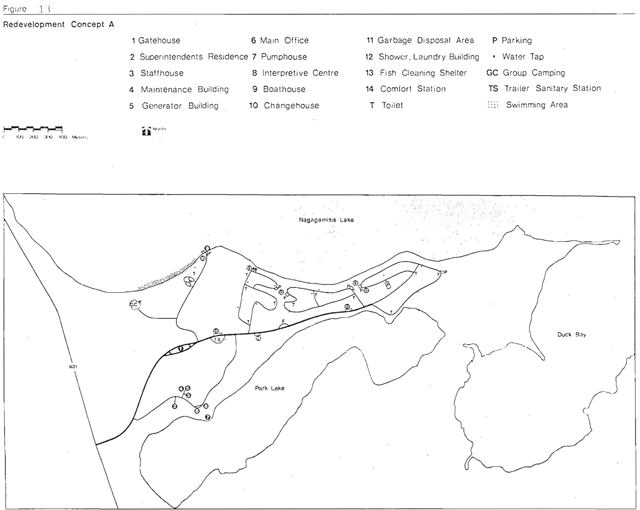
Enlarge figure 13: Redevelopment concept A (PDF)
Concept B
This concept also meets all of the stated criteria. The old park entrance and picnic road provide access to the park and an entrance control booth is provided. An additional 35 campsites are provided by adding a 50 site loop to Shaganash campground and phasingout 15 existing sites. Total campsite development is 200. Again a new day-use area is located west of the present boat launch. Additional facilities include a new maintenance building, shower-Laundromat building, comfort station, and group camping area. Two weak points are the location of the group camping area and access to the boat launch remains through the campgrounds.
Figure 14: Redevelopment concept B
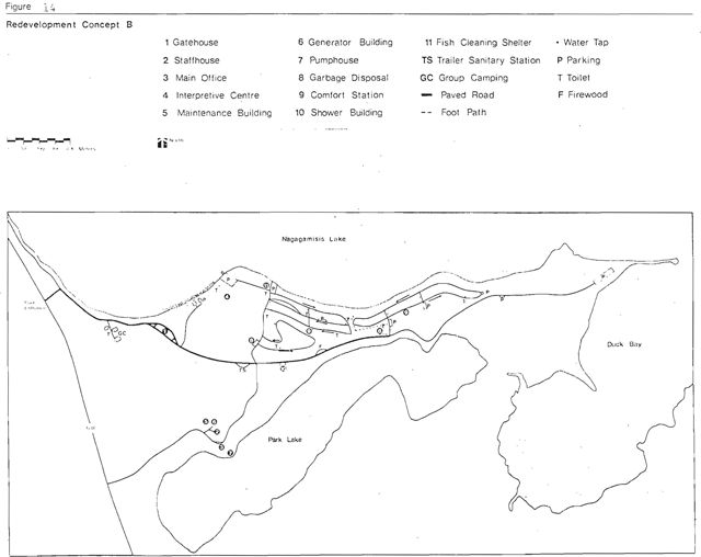
Enlarge figure 14: Redevelopment concept B (PDF)
Concept C
The present day-use area and entrance road are retained in this concept. Control of entry and use remains less than satisfactory. Fifty additional campsites bring the total campground development to 215 sites. Additional facilities include a new maintenance building, shower-laundramat building, comfort station, and group camping area. The greater use of existing roads and facilities makes this the least expensive concept.

Enlarge figure 15: Redevelopment concept B (PDF)
Concept selection
Concept B, with modifications, was selected as the one that best met the desired criteria at a reasonable cost. It was felt that an entrance road along the old cut right of way, as identified in Concept A, would be less expensive, avoid steep slopes and correct current traffic flow problems than the one proposed in Concept A and at the same time less expensive to upgrade. Major campground redevelopment was not considered justified from the point of view of cost where viable alternatives existed. Group camping and boat launch access locations were changed in order to avoid possible use conflicts. The shower building was deleted since the comfort station will contain shower facilities placed in a more central location for both campgrounds. All facilities will be removed from the existing day-use area and the road closed.
The potential for an additional 85 campsites and support facilities, was identified, but maximum development was set at 200 sites because of the limited ability of Nagagamisis Lake to sustain a large increase in fishing pressure.
Appendix 4: Summary of public participation
The Nagagamisis Provincial Park Preliminary Naster Plan was released to the public in July, 1979. Public notices advertising this event were placed in the local Hearst newspaper. Accompanying the plan was a questionnaire which brought to the reader’s attention several issues related to the plan. In total, 78 master plans were distributed with the questionnaire and 142 questionnaires were handed out at the park office. Overall 255 questionnaires were distributed.
Thirty-five percent or 90 copies of the questionnaire were returned.
Questionnaire
The questionnaire focused on 4 key items:
- park operating costs
- the Nagagamisis Lake fishery
- hunting
- trapping
Re: Reduction of park operating costs
Public opinion was requested for five alternatives designed to help reduce operating expenditures.
Alternative #l
Closing 50% of the total number of campsites
- Agree - 31%
- Disagree - 59%
- No Comment - 10%
The majority disagree with closing 50% of the campsites.
Alternative #2
Closing some of the preferred waterfront campsites for 2-3 years instead of the normal year to allow for campsite rehabilitation
- Agree - 40%
- Disagree - 47%
- No Comment - 13%
The majority disagreed with closing the waterfront campsites.
Alternative #3
Maintaining only self-use visitor services facilities
- Agree - 45%
- Disagree - 32%
- No Comment - 23%
The majority agreed with self-use visitor services facilities. The facilities which they favoured most were: self-guided trails, display boards/exhibits and publications while self-run audio visual displays were not favoured.
Alternative #4
Distributing firewood
- Sell wood- 43%
- Hand out wood free - 39%
- No Comment - 18%
No definite trend was evident.
Alternative #5
Having an honour system for fee collection
- Agree - 21%
- Disagree - 71%
- No Comment - 8%
The majority disagreed with an honour fee collection system.
Re: Improvement of the Nagagamisis Lake Fishery
The Ministry has become concerned over the last few years with the decline in size and number of fish caught in Nagagamisis Lake. Respondants were asked if they supported the outlined alternatives in an effort to rectify the situation.
- Having a shorter fishing season.
- Agree - 41%
- Disagree- 31%
- No Comment - 28%
- The majority that responded agreed to reducing the fishing season.
- Having a smaller catch limit.
- Agree - 41%
- Disagree - 23%
- No Comment - 36%
- The majority that responded agreed to a smaller catch limit.
- Having other restriction.
- Agree - 48%
- Disagree - 10%
- No Comment - 42%
- The majority felt that other restrictions were required (i.e. minimum weight or length).
Re: Hunting in Nagagamisis Provincial Park
Hunting, although occurring within the park, is not sanctioned by policy and current legislation. (However, an interim regulation permitting hunting is being sought.) Respondents were asked to select one of the alternatives outlined.
- prohibit in all of the park - 55%
- prohibit in only the development and nature reserve zones - 33%
- not prohibit at all - 7%
The majority felt that hunting should be prohibited in the park.
Re: Trapping in Nagagamisis Provincial Park
Trapping, by legislation, is permitted within the park. Respondants were asked to select one of the alternatives outlined.
- permit in all of the park- 21%
- permit in only non-significant areas of the park - 20%
- prohibit in al l of the park - 51%
The majority felt that trapping should be prohibited in the park.
References
Burns, J. A. Faunal Analysis of the Duck Bay Site (Dild - 12). Nagagamisis Provincial Paik, Hearst District, Ontario, 1973. (on file: Ministry of Natural Resources, Cochrane, Ontario)
Chapman, L. J. and M. K. Thomas. The Climate of Northern Ontario. Climatological Studies No. 6, Department of Transport, Meteorological Branch, Toronto, 1968.
Davidson, R. J. The Geology and Geomorphology of Nagagamisis Provincial Park, Northern Region. Resource Inventory Report, Ministry of Natural Resources, Park Planning Branch, Environmental Planning Section, Toronto, 1973.
Department of Lands and Forests. Planting and Landscaping for the Provincial Parks of Ontario. October; 1968.
Dreimanis, A. and P. F. Karrow. Glacial histor of the Great Lakes - St. Lawrence Region, the classification of the Wisconsin (an) Stage and its correlatives. XXIV International Geological Congress, Montrea1, Canada, 1972.
Land Use Co-ordination Branch. Lake Planning. Ministry of Natural Resources, 1975.
Maycock, P.F. A preliminary report on the life science systems: Interim report presented at the 6th Ontario. Provincial Park Planners Meeting, Cochrane, Ontario, February, 1976.
Ministry of Industry and Tourism. Camping, Ontario 1976. Toronto. Ministry of Natural Resources. A Method of Calculating Carrying Capacity, Potential Attractiveness and Management Input of a Site for Varied Use. Research Report #94, Forest Research Branch, Division of Forests.
Ministry of Natural Resources, Northern Region. Northeastern Ontario Recreation Survey Report. Timmins, 1975.
Ministry of Natural Resources. Planning Guidelines and Design Standards for the Ontario Provincial Parks System. November, 1973.
Ministry of Natural Resources. Technical Analysis of the Natural Resources: Northeastern Planning Region Strategic Land Use Planning Program, Toronto, 1973.
Norman, G. W. H. The last Pleistocene ice-front in Chibougamou district, Quebec: Royal Soc. Canada, Trans., series 3, v. 32, sect. 4, p. 69-86, 1938.
Pendergest, J. Historic Sites Survey and Inventory of Nagagamisis Provincial Park. Ontario Ministry of Natural Resources, Cochrane, Ontario, 1973.
Perraton, D. J. A Brief Ecological Survey of Nagagamisis Provincial Park, Algoma District, Ontario. Resource Inventory Report, Ministry of Natural Resources, Park Planning Branch, Environmental Planning Section, Toronto, 1973.
Pollock, J. Archaeological Surveys and Excavation in Nagagamisis Provincial Park. Hearst District, Ontario, 1973. (on file: Ministry of Natural Resources, Cochrane, Ontario)
Rowe, J. S. Forest Regions of Canada. Department of Northern Affairs and Natural Resources, Forestry Branch, Bulletin 123, 1959.
Stockwell, C. H. Fourth report on structural provinces, orogenies and time classification of rocks of the Canadian Precambrian Shield. Geological Survey of Canada, 1964.
Yarranton, G. D. Nagagamisis Provincial Park Background Information Package. Ministry of Natural Resources, Northern Region, Cochrane, 1975.
Footnotes
- footnote[1] Back to paragraph Canadian Government Office of Tourism, Vacation Travel by Canadians in 1976, CGOT August 1977
- footnote[2] Back to paragraph Indians having rights under Treaty 9
- footnote[3] Back to paragraph Inadvertently non-local hunters who traditionally use the park were not surveyed. A hunter survey during spring and fall 1980 will correct the situation.