Ontario’s Great Lakes Strategy 2016 progress report
This progress report outlines some of the key accomplishments and new scientific findings established during the first three years of Ontario’s Great Lakes Strategy. It represents the actions across 14 different Great Lakes ministries and numerous partners, including First Nation and Métis communities, municipalities, conservation authorities, environmental organizations, the science community, and the industrial, agricultural, recreational and tourism sectors.
Message from the Minister
On behalf of all of Ontario’s Great Lakes ministers, I am pleased to present this first Great Lakes Strategy progress report.
The Great Lakes are vitally important to the people of Ontario for our drinking water, quality of life and prosperity.
The Great Lakes and St. Lawrence River watersheds hold nearly one-fifth of all the fresh surface water on the planet. For Ontario, this global ecosystem is both a tremendous gift, and a great responsibility.
We rely on this remarkable system of lakes for the water we drink, for the energy that powers our communities, for industry and for moving goods to market. With over 98% of Ontarians now living in the watersheds of the Great Lakes and St. Lawrence River, these watersheds also give most of us our beaches, our waterfronts, our nature experiences and the places we call home.
When we released Ontario’s Great Lakes Strategy in 2012, we set out priority actions that the Government of Ontario, working with partners, would take to help keep the Great Lakes drinkable, swimmable and fishable for generations to come. Ontario’s Great Lakes Strategy included a commitment to reporting on progress after three years.
This progress report outlines some of the key accomplishments and new scientific findings during the first three years of Ontario’s Great Lakes Strategy. It represents the efforts across 14 different ministries and numerous partners.
Together, with our many Great Lakes partners, we are working to protect water, restore nature and focus efforts on priority geographic areas such as wetlands. We have been able to learn from and work with First Nations in implementing Ontario’s Great Lakes Strategy. We are helping Ontarians connect with and benefit from these majestic lakes. But there is still more work to be done. We need to continue to invest in science and monitoring of our Great Lakes waters to better inform us of threats to the lakes. We will use this science to ensure we are making informed decisions to better protect and improve the quality of the lakes.
New scientific research over the past few years also underscores the vulnerability of our Great Lakes. For example, in the summer of 2015 Lake Erie experienced its biggest harmful algal bloom ever recorded. This report shares some recent science on the causes of Lake Erie’s water quality issues and on other pressing issues such as the impacts of climate change in the Great Lakes.
In October of 2015, the Ontario Legislature passed a new law, the Great Lakes Protection Act. This act recognizes the diverse issues facing the Great Lakes, from invasive species to pollution to climate change. It provides new tools to better tackle these challenges.
The act enshrines Ontario’s Great Lakes Strategy as a living document and ensures that Great Lakes progress reports will be released every three years.
Healthy Great Lakes are essential to the success of our province. We need to work with all our partners to increase our efforts to protect and restore the Great Lakes. Only by working together can we ensure that our children will inherit a legacy of a healthy and resilient Great Lakes ecosystem.
I encourage all Ontarians to read this report and to get involved in protecting our Great Lakes.
Glen Murray
Minister of the Environment and Climate Change
Introduction
Lake Superior, Lake Huron, Lake Erie, Lake Ontario and the St. Lawrence River — nearly everyone who lives, works or travels in Ontario, knows at least one of these magnificent bodies of water, their watersheds and connecting rivers. In fact, whenever you catch a fish, bike along a trail, visit a provincial park, turn on the faucet to get a drink of water or enjoy a glass of wine from an Ontario vineyard, chances are you are enjoying the benefits of the Great Lakes. We have the world’s longest freshwater coastline − and more of the Great Lakes and St. Lawrence River’s water and coastline than all of the U.S. Great Lakes States combined.
The Province developed Ontario’s Great Lakes Strategy in response to new pressures that were putting the Great Lakes in jeopardy. Scientists who study the Great Lakes were warning us that the lakes were at “a tipping point” of irreversible decline. Our commitments in Ontario’s Great Lakes Strategy included a promise to report back to Ontarians in three years on our success in carrying out the Strategy as part of our shared responsibility to protect the Great Lakes.
In this report you will find highlights of Ontario’s Great Lakes achievements organized around the six goals of the Strategy:
- Goal 1: Engaging and empowering communities
- Goal 2: Protecting water for human and ecological health
- Goal 3: Improving wetlands, beaches and coastal areas
- Goal 4: Protecting habitats and species
- Goal 5: Enhancing understanding and adaptation
- Goal 6: Ensuring environmentally sustainable economic opportunities and innovation
The report spotlights developments in Great Lakes science, as well as some measures we are using to track our progress. Throughout the report you will find links to comprehensive resources about the Great Lakes, including detailed Ontario and binational technical reports on the health of the Great Lakes, their water quality and biodiversity.
This first progress report represents actions and efforts across the 14 Great Lakes ministries led by the Ministries of: Environment and Climate Change; Natural Resources and Forestry; Agriculture, Food and Rural Affairs; Municipal Affairs and Housing; Economic Development, Employment and Infrastructure; Aboriginal Affairs; Tourism, Culture and Sport; Health and Long-Term Care; Transportation; and Intergovernmental Affairs. Input has been provided by the Ministries of Education, Energy, Research and Innovation, and Northern Development and Mines. The report also represents some key actions of First Nations and Métis communities, municipalities, conservation authorities and watershed groups, environmental organizations, the scientific community and academia, the industrial, agricultural, recreational and tourism sectors and the general public.
We recognise that the Great Lakes are a shared system. Ontario’s partnerships with Canada and neighbouring jurisdictions are essential to achieving resilience for the Great Lakes. Ontario also recognises that with so much of the Great Lakes system within our province, we have a responsibility to take action to protect these shared waters. Although this report describes many positive developments since the release of the 2012 Strategy, it also contains recent scientific findings that remind us of the stress these lakes are under. More needs to be done to restore and protect the Great Lakes ecosystem.
We thank all of the organizations and individuals who have contributed to the progress and successes that this report describes.
The Great Lakes – the foundation of Ontario’s economy and quality of life
The Great Lakes are a source of enormous economic benefit to Ontario and the foundation of Ontario’s growth and development. They are vital to our well-being and provide invaluable amenities and services. The Great Lakes and their watersheds:
- generate 80% of Ontario power (hydro and cooling)
- provide recreational fishing opportunities to about 385,000 anglers whose total direct expenditures and investments wholly attributable to recreational fishing in the Great lakes are about $432 million annually
- are home to over 95% of Ontario’s agriculture and food production
- provide a navigable seaway to support base industries that depend on marine transport including the steel, construction, agriculture, energy and chemical industries
- provide sources of drinking water for a majority of Ontarians
Ontario’s new Great Lakes Protection Act, 2015
On November 3, 2015, Ontario’s Great Lakes Protection Act, 2015, received Royal Assent. This new law reflects the goals and principles of Ontario’s Great Lakes Strategy and enshrines it in law, setting out detailed requirements for Strategy contents, reporting and periodic review.
The act is designed to help address the significant environmental challenges facing the Great Lakes and St. Lawrence River Basin, including the changing climate. It identifies some initial priorities for immediate action, such as reducing harmful algal blooms. At the same time, this legislation enables public bodies to identify and target actions on priority issues and geographic areas. It provides new tools, including:
- establishing a Great Lakes Guardians' Council, a forum to help improve collaboration among Ontario’s Great Lakes partners
- the authority to set Great Lakes targets along with action plans
- enabling communities and governments to focus actions on local or regional problems through plans known as “geographically-focused initiatives”
- establishing or maintaining monitoring programs on key ecological conditions
This document fulfills the commitment in Ontario’s Great Lakes Strategy to report back after three years of the release of the Strategy. Our next progress report will deliver on Section 8 of the act’s detailed reporting requirements. In addition to reporting our progress we will provide details about a suite of environmental monitoring programs and include information on targets set. Under the act we have also committed to launching a review of Ontario’s Great Lakes Strategy by December 2018 and every six years thereafter.
Great Lakes Protection Act, 2015.
Goal 1: Engaging and empowering communities
Measuring progress on local community action
Since 2012, the Great Lakes Guardian Community Fund (GLGCF) has awarded $4.5 million to 221 projects, while partners have contributed over $15.8 million in support. It is our target to see continued increases in these figures as more individuals and communities become involved in the protection and restoration of the Great Lakes.
GLGCF project achievements include:
- engaging over 11,000 volunteers
- planting 85,125 trees (trees, shrubs and plants)
- releasing 2,133 fish
- collecting 586 bags of garbage
The high level of participation in GLGCF projects shows Ontarians are connecting with their Great Lakes and taking action to make a difference.
Local community action programs
Through hands-on activities, communities are taking action to protect the Great Lakes. In 2012 the Great Lakes Guardian Community Fund (GLGCF) was established, providing grants to not-for-profit organizations and First Nations and Métis communities to support projects with benefits to the Great Lakes and their connecting rivers and watersheds. For example:
- the Ontario Federation of Anglers and Hunters are helping to eradicate the water soldier - an aquatic invasive plant species - from the Trent Severn Waterway (the waterway which connects Lake Ontario and Lake Huron). Using a mechanical harvester approximately 192 cubic yards of water soldier was removed from the waters.
- Environmental Defence is a non-profit organization working with the community to create "The Living Beach," a rain garden project at Woodbine Beach in Toronto on Lake Ontario. Beach visitors will experience a rich and diverse natural habitat in an urban centre. The project also includes workshops to teach the benefits of creating home rain gardens (gardens that take advantage of rainfall and reduce stormwater runoff).
Building awareness
Ontario Parks and its partners offer programs that help people of all ages connect with the natural and cultural history of the Great Lakes. Each summer over half a million park visitors take part in over 9,000 staff-led natural heritage education programs. Millions more learn about Ontario’s natural and cultural heritage through museums, educational signage, publications and social media. Ontario offers a Learn to Camp and a Learn to Fish program at dozens of provincial parks and outdoor areas in Ontario. These programs introduce thousands of Canadians (often new Canadians) to camping and fishing experiences in a safe, fun and encouraging environment. The programs are consistent with the vision and principles of the Ontario Children’s Outdoor Charter. The Charter aims to get children outside to discover nature’s wonders.
Since the release of the Strategy, Ontario has been working with elementary and high school teachers to provide opportunities to use the Great Lakes and their watersheds as context for teaching and learning. In 2015, Ontario supported the Children’s Water Education Council in creating a new Great Lakes Activity Centre for the Children’s Water Festival. Twenty-eight festivals were held across Ontario with 60,000 student participants.
Ontario has supported new Great Lakes content for a one-of-a-kind program called EcoSchools. EcoSchools is an environmental education and certification program for students in kindergarten to Grade 12.
Ontario worked with local conservation authorities and other environmental partners to support teachers and school boards in creating Great Lakes learning opportunities. The result was a series of conferences for Grade 11–12 Specialist High Skills Major teachers and students across the Great Lakes Basin. More than 500 students met with Great Lakes professionals and took part in lakeside hands-on activities. More conferences are scheduled for 2016 due to the enthusiastic response from teachers, students and Great Lakes professionals. Ontario’s work has supported school boards, conservation authorities and other Great Lakes partners in forging relationships that will help build greater Great Lakes awareness and provide students with community-connected experiential learning opportunities.
Ontario’s conservation authorities: Protecting the Great Lakes watershed
In 2013, Conservation Ontario developed an interactive online Great Lakes watershed map that lets users identify their watershed and its connection to its Great Lake. The map showcases Great Lakes watershed features and functions, the water cycle, benefits of the Great Lakes, stressors on the lakes, and actions and activities taking place to help the lakes.
Measuring progress on building awareness
To support our efforts to build Ontarians’ Great Lakes awareness, Ontario assesses the number of participants in Ontario Parks natural heritage programs and the number of teachers engaged through Ontario’s Great Lakes initiatives. Each summer, 2.8 million park visitors take part in Ontario Parks education programs. Since the launch of the Strategy, approximately 2000 teachers have been engaged by Ontario’s Great Lakes initiatives.
Collaboration and partnerships
Ontario’s cultural institutions attract millions of visitors each year. They help to educate and engage visitors through experiences that deepen their connection to the Great Lakes. For example:
- The Toronto Zoo established the Toronto Zoo Great Lakes program in 2014 which provides students and teachers across seven school boards with resources that incorporate the Great Lakes into lesson plans and learning activities.
- The Ontario Science Centre is exploring a plan to redevelop the Great Lakes exhibit to make it more interactive and accessible to a wide range of visitors.
- The Royal Ontario Museum is a member of the Ontario Biodiversity Council and the Biodiversity Education and Awareness Network, helping to achieve the goals of Ontario’s Biodiversity Strategy. The museum supports biodiversity education and awareness including the development and distribution of curriculum-based lesson plans and other resources about the diversity of living things.
Investing in the Great Lakes
In addition to the base funding for core programs across all ministries, Ontario invests an additional $15 million annually toward projects that directly benefit the Great Lakes. Since 2007, Ontario has invested more than $140 million into 1,000 local Great Lakes protection projects that have reduced harmful pollutants, restored some of the most contaminated areas and engaged hundreds of partners and community groups to protect and restore the health of the Great Lakes. Since 2007, Ontario has also invested more than $660 million in upgrades to municipal wastewater and stormwater infrastructure in the Great Lakes Basin.
Engaging social scientists on the future of the Great Lakes
In 2015, the Great Lakes Futures Project was completed and featured in a special issue of the Journal of Great Lakes Research. The project engaged Great Lakes experts across many sectors, and 21 Ontario and U.S. research organizations and universities. The project identified driving forces that influence the air, watershed and water bodies of the Great Lakes region. Researchers examined these drivers of change and generated four potential future scenarios for the Great Lakes-St. Lawrence River Basin. Based on a structured scenario analysis and extensive stakeholder engagement, researchers proposed areas of governance and policy improvement to achieve a thriving and prosperous future for the region. The project also contributed to broadening and strengthening a network of Great Lakes experts across many sectors and regions.
Strengthening and building relationships with First Nations communities
"The Great Lakes are the heart of our Nation" Rhonda Gagnon, Anishinabek Nation
Ontario’s Great Lakes Strategy and the Great Lakes Protection Act, 2015 recognize First Nations’ relationship with the Great Lakes-St. Lawrence River Basin. For millennia, First Nations peoples have lived in the Great Lakes Basin – fishing, hunting, farming and trading, while maintaining a spiritual and cultural relationship with the Great Lakes.
In implementing the Strategy, we have engaged with and continued to strengthen and build relationships with First Nations communities and organizations. The act recognizes that First Nations maintain a relationship with water. The act re-affirms that it does not abrogate or derogate from the protection provided for existing Aboriginal and treaty rights. The act recognizes that First Nation may offer their traditional ecological knowledge to help carry out anything done under the act such as reviewing or amending the Strategy, establishing targets, preparing plans, deciding whether to approve a proposal for an initiative, and deciding to seek Cabinet approval of a geographically-focused initiative The act requires the Minister of the Environment and Climate Change to consider traditional ecological knowledge if offered.
Traditional ecological knowledge is already offered and considered in some provincial decisions. For example, Walpole Island First Nation was consulted on traditional ecological knowledge about species at risk affected by a new highway in the Windsor area. This knowledge has been valuable in mitigating the impacts of development on those species. Walpole Island First Nation collaborated on protection initiatives through various ecological circles (public gatherings on Walpole Island) to learn more about species at risk and their significance to the First Nation and Windsor communities. Walpole Island First Nation’s business, Danshab Enterprises, became a valuable partner with the Province in transplanting species at risk.
In early 2016, Ontario worked in partnership with Canada and the Chiefs of Ontario to host the first annual meeting with First Nations communities under the Canada-Ontario Agreement on Great Lakes Water Quality and Ecosystem Health, 2014.
Following in the footsteps of our ancestors - elders and youth gathering
Building on the success of an initial gathering in 2014, in March 2015 over 70 First Nation youth and Elders gathered in Sault Ste. Marie on the St. Marys River between Lake Huron and Lake Superior, to participate in a three-day traditional ecological knowledge gathering, “Following in the Footsteps of our Ancestors.”
The event connected youth and Elders in order to foster discussion on Great Lakes and water issues. The purpose was to provide youth with practical traditional ecological knowledge for addressing environmental concerns, empower youth with skills to get involved in their community and provide opportunities for Elders to share their knowledge with youth. The gathering opened with a traditional ceremony. A main highlight of the event was a four-kilometre water walk led by youth where they discussed hands-on, experiential learning opportunities on how to care for water.
Over the course of the three days, youth, Elders and other participants gave presentations on water and the environment. There was a strong desire to share and experience knowledge with others, as well as discuss topics such as water spills clean-up, student research, vulnerable areas and renewable energy. There were suggestions for identifying potential partnerships, networking, collaborating, sharing knowledge and empowering youth.
In early 2016, Ontario worked in partnership with Canada and the Chiefs of Ontario to host the first annual meeting with First Nation communities under the Canada-Ontario Agreement on Great Lakes Water Quality and Ecosystem Health, 2014.
Engaging Métis communities
The Great Lakes Protection Act, 2015, recognizes that the Great Lakes Basin is a historic location where Métis identity emerged in Ontario. In implementing the Strategy, we have engaged with and continued to build relationships with Métis communities and organizations in efforts to protect these waters together. Activities are underway with Métis people on the development of a pilot project to support the use of Métis traditional knowledge in contributing to understanding and addressing key Great Lakes issues.
A Great Lakes meeting with Métis people was held in early 2016 to discuss Ontario’s various Great Lakes initiatives, including the Great Lakes Protection Act, 2015 and Ontario’s Great Lakes Strategy. Ontario also partnered with Canada and the Métis Nation of Ontario to host the first annual meeting with Métis people under the Canada-Ontario Agreement on Great Lakes Water Quality and Ecosystem Health, 2014.
Renewing the Canada-Ontario commitment to the Great Lakes
In 2014, Canada and Ontario renewed their commitment to the Great Lakes by signing a new Canada-Ontario Agreement on Great Lakes Water Quality and Ecosystem Health, 2014 (COA), the eighth COA since 1971. The Ministries of the Environment and Climate Change, Natural Resources and Forestry and Agriculture, Food and Rural Affairs have signed this five-year agreement, along with seven federal departments.
The new COA has provisions to strengthen governance and accountability measures. It also includes new annexes on Engaging First Nations, Engaging Métis, Engaging Communities and Climate Change Impacts.
During the term of the 2014 COA, the governments hope to complete all actions toward delisting five Areas of Concern and make significant progress in the remaining Areas of Concern; take targeted action in priority nearshore areas; increase investment in nutrients reduction research and monitoring, and climate change science; undertake more focused invasive species work; and provide a more strategic approach to influencing future water infrastructure investments.
The COA supports Canada’s commitments under the Canada-U.S. Great Lakes Water Quality Agreement. Ontario also continues to support other related binational efforts on Great Lakes protection. For example, senior Ontario staff serve as members of the International Joint Commission’s Water Quality Board and Science Advisory Board.
Focus for future action
Building on the accomplishments of Goal 1, future directions to enhance community engagement and empowerment on Great Lakes over the next few years will include:
- supporting Great Lakes workshops and the creation of Great Lakes learning guides to help educators deliver the EcoSchools program. Students will have the opportunity to engage in Great Lakes projects that affect their whole community. We will also work with school boards and conservation authorities to bring Great Lakes workshops to more high school students in Ontario.
- continuing to strengthen and build Great Lakes relationships with First Nations communities and with Métis communities. The Minister of the Environment and Climate Change will consider traditional ecological knowledge, if offered, when implementing the new Great Lakes Protection Act, 2015.
- working closely with federal agencies and other partners as we deliver Ontario’s commitments under the Canada-Ontario Agreement on Great Lakes Water Quality and Ecosystem Health, 2014.
Goal 2: Protecting water for human and ecological health
Protecting drinking water
Source protection involves protecting the surface or groundwater that supplies municipal drinking water systems. Protecting water at its source is a crucial first step in Ontario’s approach to delivering safe drinking water.
Ontario has 19 source protection regions. Fifteen of these rely on the Great Lakes and their connecting channels as a source of municipal drinking water. Each region has a local source protection committee made up of multiple stakeholders. These committees have developed science-based plans to identify and address existing and potential risks to municipal drinking water in their communities. Ontario has approved all plans across the 19 regions. Small and rural municipalities have received funding to assist in the implementation of these plans.
With all source protection plans now approved, implementation is well underway. Ontario will be working with the conservation authorities, municipalities and other stakeholders to ensure future source protection plan updates consider other potential risks facing the Great Lakes nearshore waters.
Supporting drinking water source protection within First Nations communities
Ontario has collaborated through voluntary partnerships with First Nations who choose to participate in Ontario’s drinking water source protection program.
Of the 19 Source Protection Committees, 12 have seats dedicated to First Nations representatives. Six First Nations communities have appointed members to sit on source protection committees in an observer capacity. Three First Nations communities passed band council resolutions under the Clean Water Act, 2006 to include their drinking water systems in source protection planning.
Ontario has provided support to these First Nations communities to help them implement their plans and to others who are exploring the best approach to protect on-reserve sources of drinking water. Examples include funding for:
- technical studies that have supported the inclusion of three First Nations drinking water systems – Chippewas of Rama, Six Nations of the Grand River and Chippewas of Kettle and Stony Point – in local source protection plans to help ensure actions were taken off-reserve to protect the First Nations’ drinking water sources.
- capacity-building in First Nations communities, which help them review local source protection plans and provide input.
- Chiefs of Ontario to develop guidance on how First Nations traditional ecological knowledge could be integrated into local source protection plans.
- the Mohawks of the Bay of Quinte to develop and deliver education and outreach addressing community drinking water source issues.
Making Ontario’s drinking water standards even stronger
In late 2014 and early 2015, Ontario consulted with the public on proposed amendments to Ontario’s Drinking Water Quality Standards in consideration of the advice of the Advisory Council on Drinking Water Quality and Testing Standards (Ontario Drinking Water Advisory Council), specifically:
- adding four new substances (chlorite, chlorate, MCPA and haloacetic acids)
- stronger standards for four existing substances (arsenic, carbon tetrachloride, benzene and vinyl chloride)
In December 2015 Ontario posted a decision notice on the Environmental Registry outlining the implementation of testing and reporting requirements regarding these standards. These standards and the requirements for sampling and testing for each will come into effect over the next four years.
Measuring progress on protecting drinking water
Ontario has an award-winning drinking water safety net. This is why drinking water meets high performance benchmarks: since 2012-13, 99.9% of drinking water tests from municipal residential drinking water systems that draw surface water from the Great Lakes Basin have met Ontario’s drinking water quality standards. We are committed to continuing to work with our partners to protect our drinking water.
Protecting water quality and reducing toxic chemicals
Canada and Ontario have developed an assessment report on the status of Tier I (of immediate concern) and Tier II (of potential concern) Substances in the Great Lakes Basin. Planned for release in 2016, the report is expected to present findings on toxic substances that have been a focus for joint Canada-Ontario reductions in the Great Lakes. It is also expected to contain information on the use and release of each substance into the environment, on monitoring data and environmental trends in the Great Lakes Basin and on government actions to reduce the substances in the environment.
In 2014, Ontario ended coal-fired electricity generation across the province. By promoting renewable energy sources through the Feed-In Tariff program, the Province not only reduced greenhouse gas emissions, it also reduced pollutants such as mercury. This is contributing to cleaner air and to making Great Lakes fish safer to eat. To learn more about how Ontario is encouraging greater use of renewable energy sources, visit the Power Authority website.
Through the Canada–Ontario Agreement on Great Lakes Water Quality and Ecosystem Health, 2014, the governments are committed to identifying a renewed set of Chemicals of Concern for which priority actions will be taken to reduce their presence in the Great Lakes Basin. Canada and Ontario are currently developing the first list of Chemicals of Concern which will include any substances identified as Chemicals of Mutual Concern through the Canada-U.S. Great Lakes Water Quality Agreement.
Measuring progress on reducing toxic chemicals
Two measures we are using to gauge the reduction of toxic chemicals in the Great Lakes are the concentration of contaminants such as PCBs in Great Lakes fish, and the related restrictions on fish consumption. Since the 1970s there has been a dramatic reduction in contaminants in Great Lakes. Harmful pollutants have been phased out or banned resulting in over 90% reduction levels for some contaminants. As the ecosystem recovers, contaminant levels continue to decline at most locations, with some exceptions. For example, a slight upward trend in contaminant levels in some Lake Erie fish is occurring. As we learn more about the toxicity of contaminants, our standards for fish consumption have become stricter over time. Fish consumption advisories continue to be restrictive for many locations, species and size classes of fish. Ontario targets continued action toward long-term reductions in contaminants and fish consumption advisories.
Protecting Ontario’s rivers and streams from salt contamination
Road salt is used to clear ice and snow from roads, parking lots and sidewalks. However adding road salt to the environment risks contaminating drinking water sources. It can also harm the health of plants, animals and aquatic ecosystems. Several public- and private-sector programs encourage the responsible use of road salt. For example the Smart About Salt Council (affiliated with Landscape Ontario) has education and certification programs for landowners and private contractors. Ontario monitors salt levels in the environment and supports research to identify salt-vulnerable areas where added protections may be needed.
Road salt and snow storage best management practices have been developed by government and industry, primarily through the Transportation Association of Canada’s Syntheses of Best Practices: Road Salt Management framework, and Environment and Climate Change Canada’s Code of Practice for the Environmental Management of Road Salts. The best management practices typically included in a Road Salt Management Plan are proven and science-based.
Ontario continually reviews standards, new technology, equipment and materials to optimize winter maintenance practices. Maintenance operations have evolved significantly over time. New technology such as the Road and Weather Information Stations are used to predict winter storms and to assist with planning and deploying maintenance equipment and materials. New products such as pre-wetted salt and equipment innovations like automatic spreader controllers enhance the effectiveness of operations and decrease environmental impacts
Spotlight on science: road salt and our environment
Freshwater mussels are particularly sensitive to chloride (a component of road salt) exposure compared to other aquatic life, especially during their early life stages. As part of the Provincial Water Quality Monitoring Network, Ontario has been monitoring concentrations of chloride in streams for decades. Chloride concentrations in many of our rivers and streams have been increasing.
Our studies have found that the application of road salt resulted in significant increases in chloride in mussel habitats. The rates of increase in chloride concentrations were highest at urbanized sites and lowest at forested sites. While scientists weren’t expecting it, they found that chloride concentrations at some sites peaked in the summer several months after the last application of road salt. This suggests that a portion of applied road salt stays in the environment and moves slowly. This has implications for freshwater mussels and other aquatic species in the Great Lakes. High levels of chloride concentrations in the summer can overlap with sensitive early life stages. It also suggests that there may be a time lag before reductions in the use of road salt are reflected in the environment.
You can learn more about the effects of salt contamination in the Water Quality in Ontario, 2014 Report.
Reducing stormwater and wastewater impacts
Better stormwater management helps communities adapt to climate change impacts, reduces sewage overflows and bypasses, and enhances protection of Ontario’s streams, lakes and aquatic life.
With input from a number of stakeholders and experts, Ontario is developing guidance on low impact development to add to its Stormwater Management Planning and Design Guidelines. This document is expected to outline how low impact development can be integrated into the stormwater management framework. It will provide guidance on targets for runoff volume control, climate change adaptation considerations and avoidance of negative effects on groundwater. It will also address the operation, inspection and maintenance of low impact development stormwater management systems. This guidance is targeted for release by the end of 2016.
In 2014, the updated Provincial Policy Statement (PPS) came into effect following review involving extensive public consultation. The PPS directs municipalities to consider the impacts of climate change in infrastructure planning and take proactive measures to promote stormwater management best practices in their infrastructure plans, including green infrastructure, low impact development and stormwater attenuation and re-use.
Showcasing solutions to enhance stormwater and wastewater management
Ontario’s Showcasing Water Innovation (SWI) program supported leading edge, innovative and cost-effective solutions for managing drinking water, stormwater and wastewater systems in Ontario communities. With 263 partnerships formed, the SWI program leveraged $35 million in partnership investments from a $17 million provincial investment. SWI has fostered innovation, created opportunities for economic development and protected water resources.
SWI funded 32 projects, of which 19 were linked to improving the Great Lakes and 16 directly involving the development and/or implementation of novel technologies and approaches for stormwater management. Six projects involved innovative wastewater treatment technologies. Examples include:
- the Upper Thames River Conservation Authority conducted pilot projects to determine the effectiveness of several best management practices for reducing phosphorus loading and erosion associated with rural drainage, ultimately reducing the potential impact of rural drainage on Lake St. Clair water quality. As a result of their work, better data and information is available on the performance of best management practices, so that better decisions can be made about best value solutions for reducing phosphorous loading and erosion in agricultural settings.
- the City of Guelph installed a novel process at its wastewater treatment facility to convert ammonia to nitrogen gas using significantly less energy than standard processes. Outcomes include a reduction of approximately 25% of the ammonia load to the facility; saving 650 kilowatt hours [kWh] of electricity per day ($17,000 per year); an improvement of effluent water quality discharged from the wastewater plant into the Grand River watershed which flows into Lake Erie; and lower greenhouse gas emissions.
- Credit Valley Conservation Authority advanced low impact development practices in Ontario by demonstrating their effectiveness and creating a series of guides to facilitate their implementation on public and private land. These practices resulted in cost-effective stormwater control even during large storms, reducing stress on aging municipal infrastructure and reducing pollutant loading to Lake Ontario. Guidance documents were created to help practitioners implement low impact development in their communities.
Reducing excessive nutrients
Phosphorus is the primary nutrient responsible for Great Lakes algal blooms. Following extensive phosphorus reduction efforts in the 1970s, algal blooms that had been threatening Lake Erie were largely absent. However, harmful blue-green and nuisance algal blooms began to reappear in the mid-1990s. The 2015 harmful algal bloom in western Lake Erie was the largest on record. Other locations within the Great Lakes such as the Bay of Quinte, Hamilton Harbour, the mouth of the Thames River, and the nearshore area in Leamington are also experiencing this type of algal bloom. These blooms can affect drinking water quality and be toxic to fish, wildlife and people. The die-off of these blooms is causing oxygen depletion in the central basin of Lake Erie and contributing to massive fish kills.
In addition, scientists have observed increases in the extent of nuisance algae (such as Cladophora) growing on the lakebed, particularly in eastern Lake Erie and western Lake Ontario. When these algae detach and accumulate along the coast they decompose and foul beaches and shorelines. Cladophora has also been linked to the occurrence of botulism (bacterial food poisoning) in wildlife.
Scientists are continuing to examine the causes of recent algae problems in Lake Erie. The amounts of phosphorus entering the lake had been decreasing into the 1990s but have since levelled off. A contributing factor has been colonization of the lakes by zebra and quagga mussels since the late 1980s. These invasive species have changed the bio-availability and increased light penetration in the lakes. Scientists are concerned that as the climate changes, earlier winter thaws, increased spring stream flows, and more intense rainfall events may wash more nutrients into the Great Lakes. These, combined with longer warm water periods, have the potential to increase the amount of unwanted algae.
The International Joint Commission (IJC) issued “A Balanced Diet for Lake Erie: Reducing Phosphorus Loadings and Harmful Algal Blooms” in 2014. This document made 16 recommendations relating to setting phosphorus reduction targets, reducing phosphorus loadings from agriculture, urban sources and septic systems, and strengthening monitoring and research. The IJC also released “Economic Benefits of Reducing Harmful Algal Blooms in Lake Erie” in 2015, which estimates nearly $71 million (U.S.) in lost economic benefits from the 2011 harmful algal bloom in the western basin of Lake Erie, and an additional $65 million from the 2014 bloom (Canadian and U.S. sides).
Phosphorus targets and actions
Phosphorus sources to Lake Erie include point sources (e.g., municipal sewage and industrial wastewater discharges) and non-point sources (e.g., runoff from agricultural lands, drainage from rural land, and urban stormwater). Given the number of sources, multi-jurisdictional and multi-stakeholder collaboration is essential for reducing nutrient loads to Lake Erie.
To help drive action in the near term, Ontario signed the Western Basin of Lake Erie Collaborative Agreement with Ohio and Michigan in June 2015, collectively committing, through an adaptive management process, to a 40% reduction in phosphorus entering Lake Erie’s western basin by the year 2025 with an aspirational interim goal of a 20% reduction by 2020 (from a 2008 base year). Ontario has also worked with the U.S. Lake Erie states of Ohio, Michigan, New York, and Pennsylvania through the Great Lakes Commission to develop a Joint Action Plan for reducing nutrient loadings to Lake Erie, which was released on September 29, 2015. Commitments arising from these initiatives will be incorporated into and implemented under the Domestic Action Plan for Lake Erie being developed by Ontario and Canada. Ontario actively worked with Canada and the U.S. to establish binational nutrient targets for Lake Erie, which were formally adopted in February 2016. Ontario is currently working with Canada to develop a Domestic Action Plan for Lake Erie, and plans to engage the Great Lakes community in 2016 to identify actions to address excessive nutrients and algal blooms.
Binational targets have been established to address harmful algal blooms in the western basin of Lake Erie (by addressing the Maumee River in Ohio), localized harmful algal blooms observed in the vicinity of several river mouths (the Maumee River in Ohio, five other watersheds in the U.S. and the Thames River and Leamington tributaries in Ontario), and oxygen depletion in the central basin of Lake Erie. In general, the targets call for a 40% reduction in phosphorus loads using 2008 as a base year. While scientists agree that the majority of the loadings to Lake Erie’s central basin are from U.S. sources, Ontario must do its fair share of reducing phosphorus loads by 40%, which translates to approximately 212 tonnes.
Ontario is taking action at home to complement these efforts. The Great Lakes Protection Act, 2015, requires the Minister of the Environment and Climate Change to set at least one target to support the reduction of algal blooms within two years, and Ontario will be consulting on a target.
Ontario’s 12-Point Plan on blue-green algal blooms outlines how we are working with our many partners to prevent and respond to algal blooms in the Great Lakes and other lakes and rivers, and protect drinking water supplies.
While current efforts are focussed on Lake Erie, future efforts will next be directed to establishing targets for Lake Ontario.
Measuring progress on Lake Erie nutrients
Ontario and its partners will work to achieve our binational phosphorous load reduction targets, and improved ecosystem outcomes for Lake Erie. We will continue to evaluate our progress on Lake Erie nutrients by ensuring that phosphorus loads into western and central Lake Erie from Ontario sources are measured. Ontario and its partners are working to determine how to best measure phosphorus at the mouths of key tributaries to track progress. We will also track the frequency and magnitude of Lake Erie western basin algal blooms and central basin hypoxia (oxygen depletion). Western basin algal blooms are increasing in frequency and severity. Phosphorus concentrations measured at drinking water intakes in the western basin have significantly decreased in comparison to the 1960s, but have been on the rise since the 1990s.
Spotlight on science: algal blooms
Ontario researchers are adding to our understanding of harmful algal blooms and nuisance algae. We are monitoring nearshore water quality at 17 drinking water intake sites in the Great Lakes, including five locations in Lake Erie. We also monitor 70 sites in the nearshore of the lakes to track long-term trends in Great Lakes water quality. These long-term data sets, together with special studies in the lakes and their tributaries, are helping us measure and understand nearshore responses to climate change and other stressors, including changes in nutrient loading. This is part of Ontario’s science contribution to the work on phosphorus reduction targets and actions.
Several recommendations for action have been made as a result of Ontario’s scientific studies. For example, science undertaken on Lake Erie’s central basin indicated that oxygen depletion (anoxia) caused the significant fish kills observed in 2012. This research helped to clarify the need for phosphorus reductions to protect Lake Erie’s central basin from oxygen depletion events.
Findings from stream monitoring and nearshore water quality research in the Leamington area indicated that high nutrient levels in coastal waters were primarily due to high phosphorus in the local water courses and water runoff along the shoreline, rather than being caused by the Leamington Water Pollution Control Plant. The study showed that while the phosphorus loads to this shoreline are minor compared to the total loads to the western Lake Erie basin, the chronic high levels of phosphorus in this area are stimulating unwanted algae growth. This area has now been identified as a binational priority for phosphorus reduction.
Scientific studies have also been assessing the distribution and persistence of excessive Cladophora and other attached algae in the Great Lakes, to help tackle algal fouling along beaches and waterfronts.
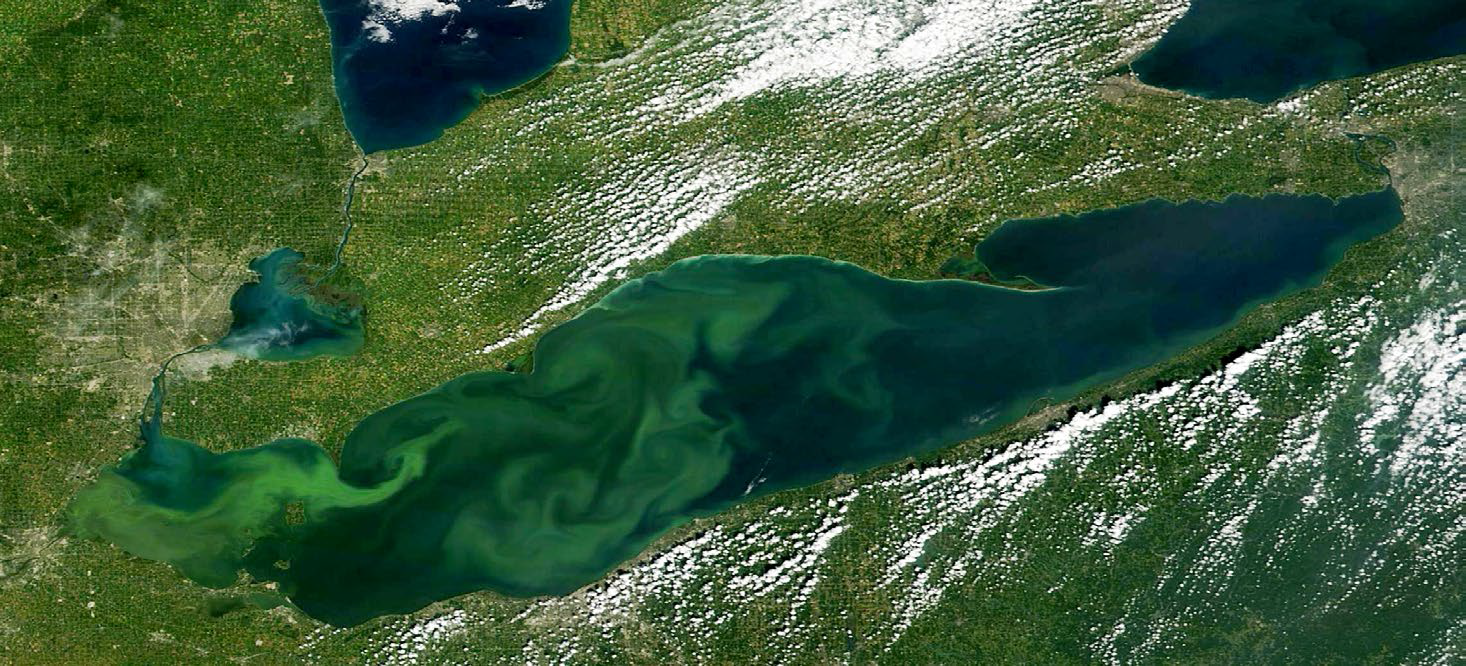
A satellite image of a Lake Erie algal bloom, taken on September 6, 2015 (NASA Worldview)
Agricultural best management practices
To develop and validate best management practices, Ontario’s technical specialists work with university scientists, the farming and agri-business community, federal counterparts and conservation authorities. Projects focus on nutrient management and water quality, as well as other Ontario agri-environmental needs such as natural heritage stewardship, soil health, energy efficiency and climate change.
The Best Management Practice Verification and Demonstration Program is designed to ensure best management practices are continually adapting to remain relevant with respect to modern agricultural production methods, evolving environmental issues and best available science. Program priorities are updated on a yearly basis to ensure research efforts are focused in the areas of primary concern. The program presently funds applied research to develop, validate and improve practices for water quality, soil health, climate change and nutrient management. Ontario provided six sites across Southern Ontario with farmland runoff monitoring equipment, automated water samplers and meteorological stations. This equipment supports year-round, high-frequency data collection for developing and verifying innovative best management practices that are good for the Great Lakes and effective for farmers. Positive actions are supported through applied on-farm research projects which develop and test the economic and environmental benefits of agriculture and food technology across the province.
For example, the best management practice for streamside grazing helps farmers properly plan and manage streamside grazing through improved buffers, alternative water access, stream crossings and pasture layout to benefit the environment. Other research examined the use of cover crops in field production systems and confirmed that keeping the soil surface covered during the late fall and early spring can reduce phosphorus and nitrogen loss into waterways.
Great Lakes agricultural stewardship
Agricultural land and nutrient management practices affect the health of soils. Good soil health prevents soil erosion, thereby reducing nutrient loss.
In February 2015, Ontario announced the Great Lakes Agricultural Stewardship Initiative. The program commits $16 million over four years to improve soil health and reduce nutrient loss from agricultural sources. Funding is provided through Growing Forward 2, a Canada-Ontario initiative, and targets the Lake Erie basin and the southeast shores of Lake Huron. This initiative supports private- and public-sector partnerships with cost-share funding to:
- identify ways producers can improve soil health, reduce runoff and improve pollinator habitat
- modify equipment to address risks related to manure application and pollinator health
- adopt best management practices, including soil erosion control structures, cover crops, residue management, buffer strips and field windbreaks/windstrips
The Great Lakes Agricultural Stewardship Initiative also offers technical training for service providers and education and outreach activities including local workshops
In 2015, with the support of Ontario, Fertilizer Canada and the Ontario Agri-Business Association launched a 4Rs Nutrient Stewardship program: “right fertilizer, right rate, right time, right place.” The adoption of this program was one of the recommendations of the Great Lakes Commission’s Joint Action Plan for reducing nutrient loads to Lake Erie. Under the 4Rs program, crop advisors use best management practices to make the most efficient use of fertilizers and can receive formal certification. The goal is matching nutrient supply with crop requirements and minimizing nutrient losses from fields.
Ontario is working collaboratively with federal departments, agricultural organizations and conservation authorities in the Lake Erie basin. This work focuses on finding better ways to understand and identify the Ontario agricultural areas that are most at risk of soil and nutrient loss. This work will help us meet phosphorus reduction targets to reduce harmful algal blooms and restore conditions in Lake Erie.
Early findings suggest that geographical features such as soil type and slope are important factors in how much nutrients are lost to streams from agricultural landscapes. Also, it appears that the largest amount of nutrient loss from agricultural landscapes occurs in winter and early spring. These early findings are helping us rethink our approaches to reducing algal fouling in the Great Lakes and set priorities.
Studying nutrients in Great Lakes agricultural watersheds
In 2013, Ontario launched the Multi-Watershed Nutrient Study. The seven-year study will examine the management of agricultural land and the extent of nutrient runoff in 11 agricultural watersheds in the basins of Lakes Erie, Ontario and Huron. This will be an ongoing study to determine the role agriculture can play in resolving a very complex issue.
This is the first broad-scale assessment of the extent of Ontario’s agricultural non-point source nutrient pollution to the Great Lakes in over 40 years. Comparative data from previous studies will be used to track changing climate conditions, to develop a “then-and-now” analysis and to model future scenarios.
Safeguarding water quantity
Ontario has worked with our Great Lakes neighbours to better protect and conserve the shared waters of the Great Lakes Basin, including improving our understanding of how water takings and climate change affect water availability. As part of this work, new rules were implemented in January 2015 for managing large water withdrawals and transfers within the Great Lakes Basin in ways that align with the Great Lakes- St. Lawrence River Basin Sustainable Water Resources Agreement signed by Ontario, Québec and the eight states that border the Great Lakes. The new rules enhanced Ontario’s existing Permit to Take Water program to ensure withdrawals in Ontario are managed to the standards of the agreement.
These new rules and Ontario’s ongoing work with our Great Lakes neighbours to support the agreement, aim to protect the waters of the Great Lakes and to allow us to better understand the impacts of water takings and climate change on the lakes.
The International Joint Commission (IJC) is a Canadian and U.S. organization established to manage shared waters such as the Great Lakes. The countries work together to investigate issues and recommend solutions.
Ontario undertakes work that contributes to activities of the IJC, helping us better understand the effects of regulated water levels in the Great Lakes. Regulating water levels can influence coastal wetlands through alterations to natural water levels and flow patterns in the Great Lakes. Ontario participates in IJC efforts in lake-level adaptive management planning to monitor the performance over the long-term of regulation plans in the Great Lakes system.
Focus for future action
Building on the accomplishments of Goal 2, future areas for action over the next few years to protect our Great Lakes waters will include:
- continuing to partner with First Nations communities to improve the quality and safety of drinking water
- taking action on harmful pollutants identified as priorities through the Canada-Ontario Chemicals of Concern process
- investigating the use of tools such as roadside ditch liners to reduce salt concentrations in surface and groundwater from highway runoff in localized salt sensitive areas
- issuing guidance on low impact development as part of Ontario’s stormwater management framework
- working with all affected partners on both sides of the border to reduce phosphorus loads to Lake Erie, to help reduce algal blooms and restore the health of the lake. Ontario will also continue to work on potential phosphorus reduction targets to help improve water quality in western Lake Ontario
- continuing to work with Québec and the eight Great Lakes States to protect and conserve Great Lakes Basin waters through the Great Lakes – St. Lawrence River Basin Sustainable Water Resources Agreement. Ontario will participate in reviewing significant water proposals, annually review Ontario’s water conservation programs and submit water use data to a regional database aimed at improving decisions and assessing water use impacts
Goal 3: Improving wetlands, beaches and coastal areas
Protecting Great Lakes coastal wetlands
Ontario’s Great Lakes coastal wetlands are among the region’s most ecologically valuable and productive habitats. Wetlands serve a variety of critical functions. They filter pollutants, store nutrients, regulate water flow to reduce flooding and erosion and are grounds for spawning, reproduction, food and shelter for many species.
Considerable work is underway to conserve and protect these threatened Great Lakes treasures. The Great Lakes Wetlands Conservation Action Plan, now in its fourth phase, is a cooperative effort by Canada, the Province, Conservation Ontario, Ducks Unlimited Canada, Ontario Nature, Nature Conservancy of Canada and other partners to more effectively protect and rehabilitate our remaining Great Lakes coastal wetlands. In 2014, the partners hosted the Great Lakes Wetlands Day with a focus on wetlands research and monitoring, policy and environmental conservation and management.
Building on over 30 years of wetland policy and partnership, Ontario is currently working across government to develop a Strategic Plan for Ontario’s Wetlands. The plan will provide a coordinating framework to guide wetland conservation. It will include a vision, goals and desired outcomes for wetlands and will set out a series of actions the Ontario government will undertake over the next 15 years to improve wetland conservation. This includes increasing our knowledge and understanding of wetland ecosystems and raising awareness about the importance of wetlands. It also includes ensuring our wetland polices are strong and effective, encouraging cooperation at all levels of government and supporting strategic partnerships for shared action on wetland conservation.
Measuring progress on conserving wetlands
Between 2006 and 2014, Ontario Eastern Habitat Joint Venture partners invested over $58.3 million to conserve wetlands and associated habitat across Ontario; this resulted in the securement of 37,379 hectares, the restoration of 12,217 hectares and the management of 46,023 hectares of wetland habitat.
Conserving migratory bird habitats in the Great Lakes
The Ontario Eastern Habitat Joint Venture (EHJV) is a collaborative partnership of government and non-government organizations in Ontario, working together to conserve wetlands and habitats that are important to waterfowl and other migratory birds. Since 1986, the Ontario EHJV and similar partnerships in other provinces have helped to implement habitat conservation programs that support continental waterfowl objectives identified under the North American Waterfowl Management Plan.
Ontario EHJV partners include: the Government of Canada, the Government of Ontario, Ducks Unlimited Canada, the Nature Conservancy of Canada, Bird Studies Canada, and Long Point Waterfowl. Partners work across Ontario, however, the focus is often in areas of southern Ontario where loss of wetland habitat has been highest.
Developing land-use planning policies that protect our wetlands
Ontario’s Provincial Policy Statement provides policy direction on land-use planning decisions across the province including the Great Lakes Basin, such as direction on the need to consider cumulative impacts of development in a watershed and improved protection for shoreline areas. Policies updated in 2014 prohibit development and site alteration in significant coastal wetlands and increase protection for all coastal wetlands in southern Ontario including the Lake Huron, Lake Erie and Lake Ontario watersheds. Currently Ontario is reviewing the Greenbelt Plan, Oak Ridges Moraine Conservation Plan, Niagara Escarpment Plan and Growth Plan for the Greater Golden Horseshoe to ensure improved direction on watershed planning and protection of wetlands during land-use planning decisions.
Protecting Lake Erie’s wetlands
The Thames River flows southwest, passing through several communities, including Chatham and four First Nations reserves, before it empties into Lake St. Clair at Lighthouse Cove. This water then flows downstream to Lake Erie. In a project on the Lower Thames River watershed, multi-agency efforts are improving water quality and increasing biodiversity through restoration of critical coastal wetland habitat. Achievements from 2012 to 2015 include restoring 35 hectares of wetland and 25 hectares of provincially significant wetland, with another 291 hectares in four sites targeted for restoration, and many community events to raise awareness and encourage participation in restoring the coastline. These efforts work towards goals of the multi-agency Thames River Watershed Clearwater Revival Initiative.
On the north shore of Lake Erie, the Rondeau Bay Watershed is home to one of Lake Erie’s few remaining intact coastal wetland systems. It is an important refuge for many species at risk and is the site of a provincially significant wetland recognized as a Ramsar wetland of international importance. This watershed is also under a great deal of pressure from rural land uses, which ultimately affect the ecosystem health of Rondeau Bay. Following the recommendations of an ecological assessment led by Ontario, federal and community partners have been working collaboratively towards goals to enhance water quality and increase habitat quantity. Actions include creating wetlands, establishing shoreline vegetation buffers and incorporating green infrastructure into municipal drain design to reduce the inflow of nutrients from agricultural activities in the watershed.
The Long Point Coastal Wetland Complex, also on the north shore of Lake Erie, is another internationally-recognized Ramsar site. It is a critical stopover for migratory birds, located at the convergence of the Atlantic and Mississippi Flyways. The complex is an Important Bird Area and identified as a priority area for restoration under the EHJV and North American Waterfowl Management Plan. With over 5,000 hectares of provincially significant wetlands, most of the lands within the Long Point Wetland Complex are protected by government ownership or conservation easement, ensuring that wetland restoration activities undertaken will remain protected for generations to come. Ontario’s federal, municipal and community partners are working collaboratively to protect and restore aquatic habitat and improve water quality in the Long Point inner bay. Achievements include acquiring wetland habitat to ensure its protection, restoring degraded wetland habitat, decommissioning a sewage lagoon and restoring it to natural wetlands, monitoring the use of reconnected aquatic habitats by fish and wildlife, and controlling invasive Phragmites (common reed, a non-native plant).
Protecting Great Lakes beaches
The Healthy Lake Huron – Clean Water, Clean Beaches initiative
Ontario is chairing the Healthy Lake Huron- Clean Water Clean Beaches Initiative. Ministries are working collaboratively with a broad range of public- and private-sector partners to take a coordinated, community approach to improve overall water quality along Lake Huron’s southeast shores. The focus is addressing nuisance algae concerns and promoting safe and clean beaches and shorelines. Farmers are using a series of best management practices to improve soil health and keep valuable topsoil in their fields and away from Lake Huron. Working in collaboration with landowners, this initiative has completed over 200 on-the-ground actions aimed at improving water quality.
Monitoring the health of Great Lakes beaches
The quality of our Great Lakes beaches can be measured by the percentage of days that they meet bacterial standards and are therefore considered safe for swimming. In the Canada-U.S. reporting framework, a beach is given a Good rating if 80% or more of its beach days meet bacterial standards; a Fair rating at or above 70%; and a Poor rating if beach days meet bacterial standards less than 70% of the time. Between 2011-2014, Lake Superior and Lake Huron monitored beaches were assessed as Good (an unchanging trend from the previous reporting cycle, 2008-2010). Lake Ontario’s monitored beaches were assessed as Fair, relatively consistent with the previous reporting cycle. Lake Erie’s monitored beach status changed most significantly, from a Fair to Poor rating. The indicator information will be published as part of the next binational State of the Great Lakes report in 2017. To see previous State of the Great Lakes reports, visit binational.net/category/a10/sogl-edgl/.
To find out real time water quality information for swimming conditions at many beaches, visit the Lake Ontario Waterkeeper website to download the free Swim Guide smartphone app.
“Blue Flag” beach certification
The Blue Flag is a certification that a community’s beach or marina meets the stringent standards of the Foundation for Environmental Education. This Blue Flag designation can support the growth of the community’s tourism and economy.
There is strong support for using the Blue Flag beach program as the standard for healthy beaches. For example, Toronto has eight Blue Flag beaches. Surveys of aesthetics clearly indicate that Toronto’s beaches are clean, monitored and well-maintained.
Many of Ontario’s RTOs focus on beaches as a key attraction for their region. For example, the Southwest Ontario Tourism Corporation which borders Lakes Erie, Huron and St. Clair has been supporting the Blue Flag program and hosting workshops to introduce a variety of stakeholders to the program. The goal of the workshops is to increase awareness of the Blue Flag designation and encourage its adoption in southwest Ontario. There are currently three Blue Flag certified beaches in the region (Canatara Park, Grand Bend and Port Stanley), and two are currently applying for their certification (Erieau Beach and Port Glasgow Beach). In 2015, the Southwest Ontario Tourism Corporation also partnered with Blue Flag and Ryerson University to collect beach visitor data.
Cleaning and restoring Great Lakes beaches
Ontario has supported communities and groups that have taken action to restore and protect Great Lakes beaches. For example:
- The Bert Miller Nature Club planted beachgrass at five public beaches to repair and enhance the natural beach topography and sand dune ecosystems on the Niagara Peninsula of Lake Erie. The Club also built and installed three boardwalks to protect globally rare ecosystems by keeping foot traffic off sensitive dune habitats; educated visitors by installing interpretive signage; and created a pamphlet to raise awareness of this unique coastal environment.
- On the north shore of Lake Superior, the Sault North Waste Management Council and 40 volunteers held a cleanup of over five kilometres of shoreline. The program involved creating an educational presentation on the dangers of illegal dumping. The presentation was delivered at two local schools and an illegal dumping web page was added to the Sault North Waste Management Council’s website.
- The Garden River First Nation community has started the Ojibway Park shoreline restoration project, which includes a beach cleanup along Lake George in the Lake Huron watershed. Over the years the beach had become degraded due to lack of maintenance. Beach cleanup will improve the aesthetics and safety of the beach area and an environmental awareness campaign will help teach beach visitors about permitted and non-permitted beach activities. Various community groups are working together to develop a monitoring and ongoing maintenance plan to sustain the improved beach conditions.
Promoting beach stewardship
Ontario’s Great Lakes Strategy recognizes the ecological, social and economic importance of our Great Lakes beaches.
To promote good beach stewardship, Ontario released a new Recreational Water Protocol and a Beach Management Guidance Document in 2014. These documents provide updated guidance for public health units on assessing environmental conditions at public beaches, tracking water quality and communicating results to the public.
Ontario Parks, communities and partners along Lakes Erie and Huron and southern Georgian Bay are sponsoring a variety of activities to promote good beach stewardship, such as beach cleanups and vegetation planting. A beach stewardship video highlights the importance of sand beaches and coastal dunes for healthy, resilient coastal communities.
Achievements in restoring Areas of Concern
For more than 40 years, local residents, community groups, First Nations and Métis communities and industries have been working in partnership with Canada, Ontario and municipal governments to restore environmental quality in the Great Lakes. Since 1987, attention has been focused on cleaning up 17 sites known as Areas of Concern (AOCs), spots along the Great Lakes and St. Lawrence River where water quality and ecosystem health had been severely degraded by human activity.
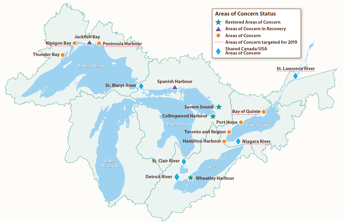
Considerable progress has been made to restore the 17 Canadian AOCs. Three AOCs in Ontario (Wheatley Harbour, Severn Sound and Collingwood Harbour) have completed all restoration actions and are no longer considered areas of concern. All restoration actions have been completed at two additional AOCs (Spanish Harbour and Jackfish Bay) and require time for the environment to recovery naturally. These two AOCs have been recognized as Areas of Concern in recovery.
Continued progress to restore environmental quality in the remaining AOCs has also been made, which is reflected in the number of beneficial uses that are no longer considered impaired (e.g. fish and wildlife deformities, loss of habitat and nuisance algal blooms). In the past three years Ontario has made substantive investments in the cleanup of contaminated sediments. Contaminated sediment management projects have been completed in the St. Lawrence River (Cornwall); Niagara River; Detroit River; Bay of Quinte; and the Peninsula Harbour AOCs. Initiatives are also underway to address environmental problems in Randle Reef in the Hamilton Harbour AOC.
Number of beneficial uses no longer impaired in Canadian AOCs
Measuring progress on Great Lakes Areas of Concern
Progress on restoring Areas of Concern (AOCs) can be measured by the number of AOCs where all priority actions have been completed. So far, this milestone has been achieved at 5 of the 17 Areas of Concern that are located wholly or partially in Ontario. We have committed to completing priority restoration actions in five additional areas by 2019 – Nipigon Bay, Peninsula Harbour, Niagara River, Bay of Quinte and St. Lawrence River (Cornwall) – while continuing to advance restoration of the remaining AOCs.
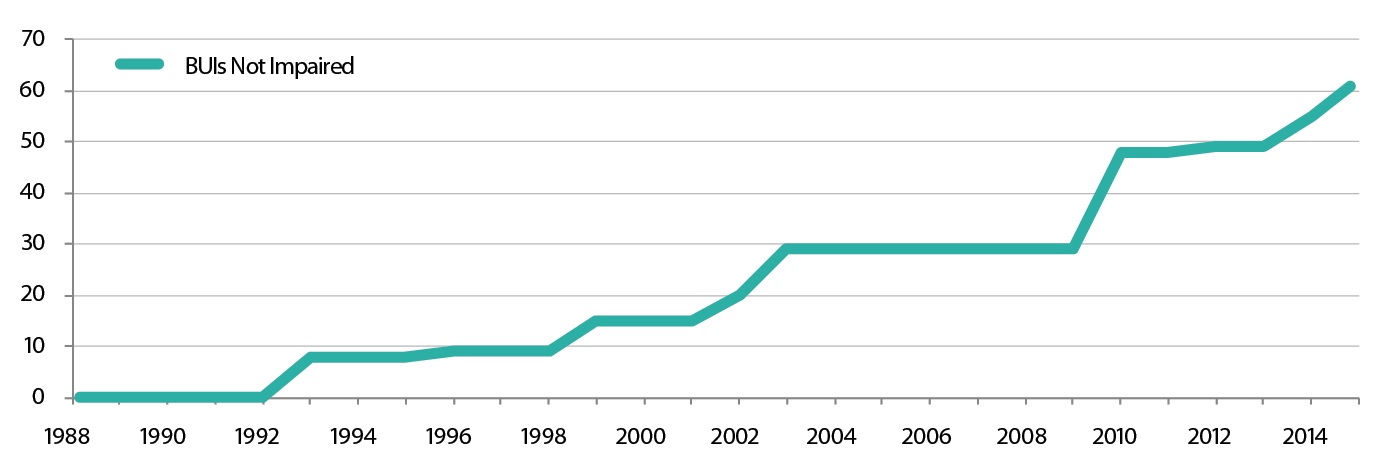
Another important measure of progress is the number of “beneficial uses” no longer impaired (i.e., valued aspects of the environment that have been restored to health). To date, 61 beneficial uses across the 17 AOCs are no longer impaired, with more than half this progress occurring in the past five years.
Cleaning up contaminated sediment at Hamilton Harbour Area of Concern
All the Great Lakes drain through Lake Ontario. It has been most impacted by the accumulation of harmful pollutants. In addition the Lake Ontario basin is home to over 56% of Ontario’s population. This puts a great deal of pressure on its environment, infrastructure and transportation corridors. Despite these challenges Ontario and its partners have made significant progress in cleaning up the Areas of Concern along Lake Ontario’s shorelines. For example Randle Reef is an area of contaminated sediment located in the Hamilton Harbour AOC. A project is currently underway to safely address approximately 695,000 cubic metres of sediment contaminated with coal tar and heavy metals. The cost of the cleanup project is estimated at $138.9 million, with funding commitments from the Government of Canada, the Ontario government, the City of Hamilton, the City of Burlington, Halton Region, Hamilton Port Authority and U.S. Steel Canada. Ontario committed $46.3 million to this sediment cleanup.
Focus for future action
Building on the Goal 3 accomplishments, over the next few years we will help to protect and restore Great Lakes wetlands, watersheds, beaches, shorelines and coastal areas through a range of actions including:
- establishing and implementing a strategic plan for Ontario’s wetlands and supporting enhanced requirements for watershed planning and Great Lakes wetland protection through land use planning policies and guidance as well as stewardship programs
- completing all priority restoration actions in Nipigon Bay, Peninsula Harbour, Niagara River, Bay of Quinte and St. Lawrence River (Cornwall) by 2019 while also making progress on the restoration of other identified Areas of Concern
- working with local partners to advance the protection and restoration of other priority areas, using new tools in the Great Lakes Protection Act, 2015
Goal 4: Protecting habitats and species
Protecting Great Lakes habitat and species
Conserving biodiversity
The Ontario Biodiversity Council, which represents conservation and environmental groups, Aboriginal organizations, industry, academia and government, renewed Ontario’s Biodiversity Strategy (OBS) in 2011. OBS guides biodiversity conservation in the province and includes actions to engage all segments of Ontario society in valuing and conserving biodiversity.
In response to OBS, Ontario developed Biodiversity: It’s in Our Nature, Ontario Government Plan to Conserve Biodiversity, 2012-2020 (BIION). This document outlines key actions across 16 Ontario ministries to help achieve the vision and goals identified in OBS. These include activities to: increase biodiversity awareness and understanding; reduce threats to biodiversity including habitat loss, invasive species, pollution, population growth, unsustainable use and climate change; enhance the resilience of ecosystems including the Great Lakes; and support science, research and information management to inform biodiversity conservation. Ontario’s Great Lakes Strategy advances actions in BIION for both engaging people and enhancing resilience.
OBS includes a commitment to report on the state of Ontario’s biodiversity every five years. The State of Ontario’s Biodiversity 2015 report, released in May 2015, assesses the status of and trends for 45 indicators and evaluates progress against Ontario’s biodiversity targets. Several indicators are related to Great Lakes stressors, including the status of aquatic alien species in the Great Lakes (see “Combating invasive species,” below).
In May 2015, over 300 people attended the first ever Ontario Biodiversity Summit, which was hosted by the Ontario Biodiversity Council and Ontario. Summit participants learned and shared information about the state of biodiversity in the province, what Ontario is doing to protect it and where to focus future conservation efforts. The Summit included a Young Leaders for Biodiversity component where college and university students and young professionals had the opportunity to learn about emerging biodiversity issues and share ideas and experiences.
"We have been in the biodiversity business for a long time, long before the term biodiversity was even coined. Many of our long-term data sets are proving to be invaluable in how they support our resource management decisions, our understanding of trends over time, and their contribution to state of the resource reporting at all levels." Marty Blake, Director, Fish and Wildlife Services Branch, Ministry of Natural Resources and Forestry
Protecting species at risk
The Great Lakes Basin is home to over 4,000 species of plants, fish and wildlife, some of which are not found anywhere else in the world. Sadly, many of our native plants and animals are at risk. The Endangered Species Act, 2007 identifies species at risk based on the best available scientific information and provides protection by requiring the development of recovery strategies or management plans for endangered and threatened species and their habitat.
Measuring progress on habitat restoration and recovering species at risk
The Province is implementing Ontario’s Land Stewardship and Habitat Restoration Program. Since its 2013 launch, the program’s $300,000 annual fund has helped improve, restore or create more than 4,662 acres of habitat including plantings of over 105,000 trees and shrubs, supporting the hiring of 182 people and leveraging over $2.3 million in project-partner funding.
To further promote recovery of species at risk in Ontario, the Province provides funding under the Species at Risk Stewardship Program. Ontario invests up to $5 million annually to encourage people to get involved in protecting and recovering species at risk through stewardship activities.
Funded projects under the Species at Risk Stewardship Program address key protection, recovery and research actions to support species at risk recovery strategies. Projects also support identified priority species (such as bats), ecosystems (such as wetlands) and issues (such as threats to pollinators). Entering its tenth year, this fund has supported over 820 projects. These projects have helped restore over 30,000 hectares of important habitat and protect many vulnerable Great Lakes Basin species, including the lake sturgeon, the American eel, the eastern hog-nosed snake and the piping plover. In 2015, the program funded over 100 new or ongoing multi-year projects.
Restoring native fish
Ontario has been collaborating with Canada and U.S. partners towards the rehabilitation of spawning habitats for several fish species, with a focus on Lake Sturgeon in the Detroit and St. Clair Rivers.
Ontario’s Understanding Constraints to Healthy Great Lakes Food Webs (“what eats what”) project focuses on Lake Ontario. This project is using advanced technologies to learn more about the habits of predatory and prey fish and invertebrates and the food-web linkages among them. Ecosystem research helps to inform restoration efforts underway on Lake Ontario for native fish species such as Atlantic salmon, bloater and lake trout.
Lake trout used to be Lake Huron’s dominant deep-water predator. The Province is continuing to work with the U.S. Geological Survey on the Lake Trout Rehabilitation Plan for Ontario Waters of Lake Huron. Parry Sound, Iroquois Bay and Fraser Bay in Northern Ontario are high-priority areas in the rehabilitation plan. Ontario is measuring progress in rehabilitating the lake trout, based on stocking success and the effectiveness of harvest restrictions.
Combating invasive species
As of 2014, over 180 non-native species have been reported to have reproducing populations in the Great Lakes Basin. No new invasive species have been discovered as established in the Great Lakes since 2006 and Ontario continues to work to prevent the establishment of new invasive species.
On November 3, 2015, Ontario was the first jurisdiction in Canada to pass an act to prevent, detect, respond to and, where feasible, eradicate invasive species. Our new Invasive Species Act, 2015 makes Ontario a national leader in invasive species prevention and management. The act gives the province new authority and tools to deal with invasive species in the Great Lakes.
The faster we can detect invasive species, the better chance we have to deal with them. To help with early detection of aquatic invasive species, Ontario scientists are working to develop new environmental DNA (eDNA) markers, unique ‘genetic signatures’ that define species.
Ontario is implementing the Ontario Invasive Species Strategic Plan (2012). Key activities in the plan include the recent passage of the Ontario Invasive Species Act, 2015, continued partnerships with the Ontario Federation of Anglers and Hunters on the Invading Species Awareness Program, and participation on a binational task force established by the Great Lake Governors and Premiers of Ontario and Québec to stop the introduction and spread of aquatic invasive species in the Great Lakes and St. Lawrence River. As part of the plan, Ontario continues to invest in the Canada-Ontario Invasive Species Centre in Sault Ste. Marie to address key gaps outlined in the plan, including the support of research and control actions to prevent the introduction and spread of invasive species. For example, the Invasive Species Centre is supporting ongoing efforts to eradicate water soldier and water chestnut in Ontario.
You can help us prevent the spread of invasive species in Ontario!
If you find an invasive species on your property or in your community, please:
- call the hotline: 1-800-563-7711
- send us an email
- use the EDDMapS Ontario app. This app allows anyone to submit invasive species observations directly from the field, using a smartphone. These reports are uploaded to EDDMapS and emailed directly to the Ontario Federation of Anglers and Hunters for verification and action
For more information on invasive species and fact sheets on those that are a concern in Ontario, visit invasive species in Ontario website.
Response to invasive species
In 2013, the Great Lakes Governors and Premiers of Ontario and Québec agreed to work together to address the threat of aquatic invasive species and identified 16 “Least Wanted” species as a priority for prevention and response. Ontario has been working on provincial risk assessments for these species, and has also undertaken response actions for the “Least Wanted” in Ontario waterways, including Asian carp, water soldier and water chestnut.
In 2014, the Governors and Premiers also signed a Mutual Aid Agreement Combating Aquatic Invasive Species in the Great Lakes–St. Lawrence River Basin. By sharing expertise and resources, this agreement amongst the Great Lakes Governors and Premiers of Ontario and Québec makes it easier to coordinate fast cross-border responses to invasive species.
Combating Asian carp
In 2005, Ontario prohibited the buying and selling of several live invasive fish species, including Asian carp. Between 2005 and 2013, Ontario Conservation Officers, working with the Canada Border Services agency, intercepted more than 18,000 kg (40,000 lbs.) of live Asian carps at the border, destined for Ontario markets. However, they continue to be a concern and a few of these fish were found in Lake Ontario as recently as the summer of 2015. Asian carp are insatiable eaters. If we don’t prevent their introduction, they could irreparably change the Great Lakes ecosystem and impact recreational and commercial fishing in our lakes. Ontario is working to keep Asian carps out of Ontario waters through a variety of efforts. With its partners, the Province is focusing on putting strong regulations and monitoring in place and conducting research to expand Great Lakes science on Asian carp. In dealing with the Asian carp threat, there are two top priorities: surveillance and prevention. Our focus is on high-risk areas of the province, especially the waters and tributaries of Lake Huron, Lake Ontario and Lake Erie.
Establishment of the Lake Superior National Marine Conservation Area
In 2007, Ontario and Canada signed an Agreement to establish a National Marine Conservation Area (NMCA) in north-central Lake Superior. An act to amend the Canada National Marine Conservation Areas Act received Royal Assent in 2015, enabling the establishment of the Lake Superior NMCA once the lands are transferred from Ontario to Canada. NMCAs are designated for the protection and conservation of Canada’s oceans and Great Lakes. This means ensured protection for Ontario’s natural and cultural heritage including bird habitats, species at risk, First Nations archaeological sites and shipwrecks. Spanning more than 10,000 square kilometres from Thunder Cape at the tip of Sleeping Giant Provincial Park in the west, to Bottle Point east of Terrace Bay, the Lake Superior NMCA is one of the largest freshwater protected areas in the world.
Focus for future action
Building on the accomplishments of Goal 4, future directions to protect Great Lakes habitats and species over the next few years will include:
- continued focus on native fish rehabilitation including Atlantic salmon, lake trout, bloater (deepwater cisco), lake sturgeon and American eel in Lake Ontario; lake trout, whitefish and lake sturgeon in Lake Erie; lake trout and lake sturgeon in Lake Huron; and walleye in Lake Superior
- continued work to prevent and respond to invasive species including completing risk assessments for species on the “Least Wanted” list, and responding to high risk species including Asian carp, water soldier and water chestnut in Ontario’s waterways
- continuing to promote the recovery of species at risk, including through funding under the Species at Risk Stewardship Program
Goal 5: Enhancing understanding and adaptation
Great Lakes research and monitoring
Great Lakes science involves collecting and analyzing data and information about the environment and using this valuable information as the basis for establishing environmental policies, setting priorities and allocating resources.
For example, to tackle harmful and nuisance algal blooms in the Great Lakes, scientists are studying many aspects of the Great Lakes ecosystem: the frequency and severity of harmful and nuisance algal blooms; the sources and types of phosphorus that are feeding the algae; the concentrations of phosphorus in different areas of a lake and the movement of phosphorus within the lake; the physical conditions (temperature, light, wind, etc.) that lead to algae growth; the relative abundance of different types of algae; and the impacts of ecosystem changes, such as invasive species, on algae growth.
Ontario scientists collaborate with others around the Great Lakes Basin to improve understanding of this shared ecosystem. For example, Government of Ontario experts participate in the meetings of the International Association for Great Lakes Research and publish in the association’s Journal of Great Lakes Research.
"Our monitoring programs and investigative studies are designed to identify problems or threats and predict their impacts – this is the foundation for problem abatement and environmental management. It’s therefore critical that we take a systems approach, to understand mechanisms and multiple interacting stresses that are driving change in Great Lakes ecosystems." Dr. Todd Howell, Great Lakes Ecologist, Ministry of the Environment and Climate Change
Lake-based science cooperation
Each year, one of the Great Lakes is the focus of the Cooperative Science and Monitoring Initiative (CSMI). Partners across Canada and the U.S., including Ontario, closely coordinate monitoring efforts to address the critical science, research and monitoring needs of the lake, identified through the Lakewide Action and Management Plans. Research topics range from emerging and legacy contaminant trends in water, fish, wildlife and humans, to ecosystem-wide assessments of fish, coastal wetlands, invasive species and tributary flows. The goal is to provide environmental managers with the information they need to restore and protect each of the Great Lakes.
For example, in 2013 Lake Ontario was given a lake-wide investigation. On the south shore of Lake Ontario scientists observed that Diporeia, the most important source of food for deep water fish, continues to decline, likely due to invasive quagga mussels. Using an underwater drone called the autonomous glider, researchers were able to map primary production in the deepest parts of the lake for the first time. Data collected from the glider shows that zebra mussels are dramatically reducing layers of algae in the deep regions of Lake Ontario, affecting the food web.
Lake-wide studies such as CSMI are important because they help us understand the effects that stressors such as invasive species have on nutrients, fish production and the food web in the Great Lakes. This information informs us on how to sustain many ecological and economic benefits of the Great Lakes.
Studying nearshore water quality
To better understand the factors that drive nearshore water quality, Ontario researchers undertook a comparison of three different regions of Great Lakes coastline.
At Point Clark on Lake Huron, the open waters are naturally low in nutrients but along the shoreline phosphorus levels are high, both from small tributaries draining nearby agricultural lands and from properties along the heavily developed shoreline.
Along Lake Ontario’s Ajax shoreline, phosphorus levels are generally low, with transient higher levels observed. Sources include nearby tributaries draining urban and agricultural lands, stormwater from the urbanized shoreline, phosphorus transported along-shore by currents from adjacent urbanised shorelines and wastewater treatment plant discharge.
At Rondeau on the central Lake Erie coast, moderate phosphorus levels in the nearshore are due to conditions in the lake, including the movement of water from western Lake Erie to central Lake Erie, as well as “upwelling” of water from deeper in the lake.
These upwelling events depend on factors such as wind direction, wind speed and lake shape. They occur frequently at both Rondeau and Ajax but less frequently at Point Clark. Each area also differs in terms of lake bottom composition (e.g., hard surfaces like rocks vs. soft surfaces like sand), abundance of attached algae, water clarity, abundance of invasive mussels and other characteristics.
This research illustrates the ways in which each area’s unique local and regional characteristics shape nearshore water quality.
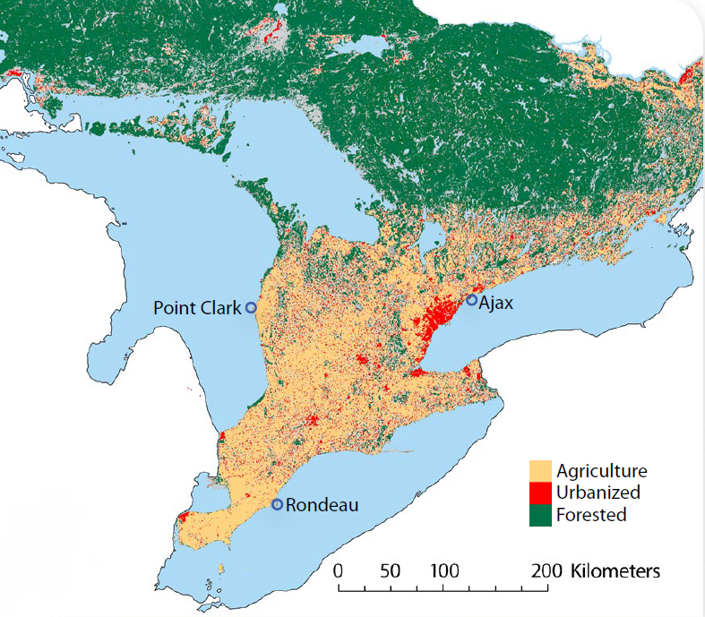
Understanding contaminant trends
Our Great Lakes monitoring programs are demonstrating declines in the levels of “legacy” contaminants (highly toxic chemicals such as polychlorinated biphenyls [PCBs], dioxins, mirex and mercury), both in fish and in sediment at the bottoms of the lakes. Levels are so low that in many areas frequent monitoring can be phased out – freeing up resources to monitor other priority areas. Thanks to successful programs to reduce and eliminate toxic chemicals, more Great Lakes fish are safe for us to eat and to eat more often (see Goal 6, Enjoying Ontario Fish).
However, there are still a few legacy contaminants with concentrations high enough to lead to advisories against eating too much of certain Great Lakes fish in areas of the lakes. There also seems to be an increase in some legacy contaminants in Lake Erie fish. This is likely due to a variety of factors including historically deposited contaminants in the lake bottom becoming active again; invasive species modifying the food web; the ways that contaminants accumulate in fish; and climate change impacts. Ontario will continue efforts to monitor and understand these legacy contaminants, as well as investigate new and emerging ones, to protect the Great Lakes ecosystem and human health.
The Great Lakes are complex and dynamic ecosystems. To understand the impacts of different pressures on the Great Lakes and to design effective protection and restoration programs, our scientists examine mixes of chemicals and investigate how chemicals change and move through the water, sediment and living creatures within the ecosystem. For more information on older and emerging contaminants in the Great Lakes, see the Water Quality in Ontario, 2014 Report.
"It’s no longer just about understanding the levels and effects of a single chemical. We know that there are a number of chemicals present in the lakes at very low levels in kind of a ‘chemical soup’ as a result of our activities and products we use. Our environmental monitoring work is aimed at better characterising that ‘soup’ to help inform management decisions." Dr. Paul Helm, Great Lakes Senior Research Scientist, The Ministry of the Environment and Climate Change
What we are learning about microplastics and microbeads in the Great Lakes
We are learning more about microplastics, thanks in part to Ontario’s active science program to determine the amounts, locations and types of microplastics in the Great Lakes.
In addition to examining the sources and make-up of microplastics, scientists are determining what happens to microplastics when they enter the Great Lakes, whether they wash up on shore, settle on the bottom or remain in the water.
We are finding microplastics in urban streams and in the final effluent from wastewater treatment plants. This is of possible concern since such small microplastics (less than 5 millimetres [mm] in size) can be ingested by fish and other wildlife. There are many sources of microplastic particles in the environment, including microbeads from personal care products, plastic litter and the supply of, and waste from, industrial processes. We are finding greater amounts in waters next to more populated and commercial or industrial areas. For example, in the first published study documenting microplastics in Great Lakes waters, samples from Lake Ontario were collected in Hamilton Harbour, Humber Bay off Toronto and in Toronto Harbour. Results show up to 6.7 million particles of plastic per square kilometre were found with the highest count occurring in Humber Bay of Toronto. This amount is approximately 10 times greater than what was found in open Lake Erie waters.
Ontario has worked with stakeholders to adopt phase-out timelines on the use of microbeads in specific consumer products and we are now working with the federal government to ensure a rapid phase- out of microbeads across Canada.
For more information on microplastics research findings in the Great Lakes visit our webpage.
Spotlight on Science: Microplastics research
Ontario is undertaking research to better understand what microplastic particles are present, what their sources are to Ontario waters of the Great Lakes and whether microplastics are accumulating at the bottom of the lakes in sediment.
Ontario’s scientists have been collecting samples in water close to urban areas. Effluent from wastewater treatment plants is also being collected and staff are collaborating with researchers at the University of Western Ontario to determine whether plastics are accumulating in sediment and on beaches. This research will help us understand what sources need better management. For example, results indicate that sources of microplastics found in the lakes include fragments (e.g. break down of litter, waste from plastics handling and manufacturing), foam particles (from packaging), microbeads and fibres.
Categories of microplastic particles found in a 2014 sampling of Lake Ontario and Lake Erie nearshore waters
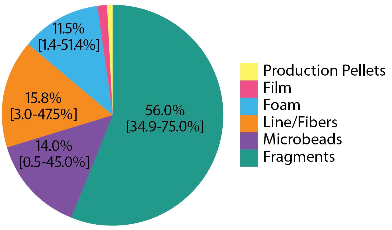
Average percentage contributions of different categories of microplastic particles found in 2014 sampling of Lake Ontario and Lake Erie nearshore waters. Samples were collected using a net with 0.36 mm openings; relative abundances are likely to differ at smaller particle sizes.
Groundwater in the Great Lakes Basin
Groundwater has long been the “invisible” portion of the Great Lakes hydrological cycle. The amount of groundwater in the Basin is estimated at approximately equal to all the water in Lake Huron, or over 1.4 billion Olympic swimming pools of water. We do know that groundwater flow into Great Lakes streams sustains cold water fish, such as brook trout, and provides water to streams during dry summer months. An action of Ontario’s Great Lakes Strategy is to improve our understanding of the role groundwater plays in sustaining Great Lakes water levels and stream flows.
Ontario scientists contributed to a report on Great Lakes groundwater science which was released in 2015 and developed under the Canada-U.S. Great Lakes Water Quality Agreement. The report is available at the binational Great Lakes website.
The focus of the report is to identify the science needs and information gaps that must be addressed to improve our understanding of how groundwater can affect the quantity and quality of Great Lakes waters. The report identifies eight major areas of science needs and information gaps including groundwater monitoring, contaminants and nutrients, urban development, aquatic habitat and climate change effects. Ontario will continue to collaborate with Canada and other partners on filling these gaps.
Sharing and communicating science
Ontario’s Great Lakes science teams – field staff, research scientists, modellers, data analysts and technicians – are part of a broader community of Great Lakes scientists. Ontario’s Great Lakes data and information are shared widely with partners across Ontario and the Great Lakes to support enhanced understanding and effective action on the Great Lakes. Our science and information is published in peer-reviewed journals; Great Lakes synthesis reports, such as binational State of the Great Lakes reports; and the paper and online publications of our partners in other orders of government, the broader public sector such as conservation authorities, non-government organizations and academia. Ontario scientists and subject matter experts are regularly sharing their knowledge with others, whether by presenting at conferences and symposia, through participation in workshops and working groups or simply by answering questions that they receive.
Measuring progress on sharing Great Lakes science data
Since the fall of 2012, an increasing number of Great Lakes-related datasets and publications have been published on Ontario’s Open Data Catalogue, publicly accessible anytime at no charge. More recent data, which are still being checked for quality and completeness, may be available upon contacting the scientist or ministry directly. Ontario’s science staff individually responded to dozens of data requests in 2013, 2014 and 2015. The number of Great Lakes peer-reviewed publications, science presentations and other reports by our scientists has increased in recent years, and we aim to sustain a strong practice of sharing and communicating scientific information to the public.
Climate Change
Ontario’s Great Lakes Strategy recognizes that climate change poses a risk to the Great Lakes ecosystem and to Great Lakes communities, and that it also exacerbates other challenges that already exist.
Ontario is working with partners to build a better understanding of climate change impacts for the Great Lakes Basin. Increased understanding will enable the development of better adaptation measures, helping ensure that people and the environment are more resilient to the effects of a changing climate.
The latest Canada-Ontario Agreement on Great Lakes Water Quality and Ecosystem Health, 2014 includes an annex focused on climate change. This annex echoes priorities in Ontario’s Great Lakes Strategy – to enhance climate change knowledge, share information about climate change impacts, help integrate climate considerations into Great Lakes management and promote adaptation action.
Ontario’s new Great Lakes Protection Act, 2015, goes one step further than the 2012 Strategy by including a focus on both the impacts and the causes of climate change.
Mitigating climate change
Climate change is not a distant threat. It is already costing Ontarians: increased insurance rates, higher food costs, and more weather-related damage.
Ontario is demonstrating leadership and commitment to fighting climate change through a series of bold actions.
In 2015, the Province released Ontario’s Climate Change Strategy. This comprehensive strategy sets out the approach Ontario will take to combat climate change including a target to reduce greenhouse gas emissions by 80% below 1990 levels by 2050.
We are moving forward with a cap and trade program to limit pollution, reward innovative companies and create more opportunities for investment in Ontario. Every dollar generated by the program will be invested in a transparent way back into green projects that reduce greenhouse gas pollution, such as public transit, electric vehicle incentives, social housing retrofits and helping homeowners save energy.
The Ontario government also introduced the proposed Climate Change Mitigation and Low-Carbon Economy Act in February 2016. This new, stand-alone law, clearly outlining the goals and details of the proposed cap and trade program will, if passed, provide a robust, accountable and transparent foundation for strong and decisive climate action.
To learn more about how Ontario is making a difference in the fight against climate change, visit the Climate Change webpage.
Enhancing understanding of climate change
Ontario’s Climate Change Strategy sets direction for adaptation and risk management approaches for communities, sectors such as agriculture and forestry, and natural resources and ecosystems. The Climate Change Strategy commits to establishing a one-window source for climate data. This will ensure open access to standardized and wide-ranging climate information, including information for the Great Lakes. It will help decision makers in private and public sectors manage their risks from a changing climate based on the best possible climate data projections.
In 2015, Ontario launched a five-year pilot project to address a range of climate change vulnerabilities in the Great Lakes Basin. The project includes reaching out to partners and communities to facilitate adaptation action, and communicating climate change research findings to decision makers, practitioners and the public.
Ontario published the first climate change vulnerability assessment which focuses on the wetlands and inland aquatic ecosystems of the Great Lakes Basin in Ontario. The research addresses wetland vulnerability to drying, wetland bird species habitats, stream temperatures, stream thermal habitats and walleye biomass. The report includes recommendations for adaptation action. The project is focused on providing information in ways that are easy to understand and helpful to decision making.
Other climate change research currently underway includes:
- the potential effects of climate change on hypoxia (low oxygen) and fish in the Great Lakes, with an emphasis on Lake Erie
- understanding potential water balance alterations in watersheds
- understanding the implications of climate change and temperature on different strains of lake trout and brook trout, and changes in their future distribution and range
- understanding flood protection and other benefits provided by wetland conservation and restoration in the Great Lakes Basin
- understanding the cumulative effects of climate change, human movement and water connectivity on the spread of aquatic invasive species
Spotlight on Science: Climate Change projections for the Great Lakes
Climate change is perhaps the greatest environmental challenge facing the ecosystem health of the Great Lakes Basin. A shared understanding of climate change impacts is essential knowledge for decision makers across the Great Lakes Basin. Scientists tell us that climate change is causing extreme weather conditions in Ontario. Intense rainfall events in the Great Lakes Basin are twice as common today as a century ago, and are projected to become even more common in the future. Bigger spring and summer storms, as well as runoff events during the winter season, cause more flooding and wash pollutants into the lakes.
Recently the Ontario Climate Consortium, in partnership with the province, McMaster University and Environment and Climate Change Canada, published the 2015 State of Climate Change Science in the Great Lakes Basin. The report focuses on climatological, hydrologic and ecological effects of climate change. The information will support Great Lakes management decisions. It also provides a strong foundation for future research efforts in the Great Lakes Basin, by identifying knowledge strengths, gaps and levels of confidence. While the primary focus is on ecosystems, connections to economic activities and social well-being were also considered, such as agriculture, nature-based tourism and human health.
Projections include: higher air temperatures and fewer frost days per year; increased water temperatures in both inland lakes and the Great Lakes; increased annual precipitation including more winter rain; decreased water levels in wetlands; and loss of habitat ranges for many plants and animals.
Helping communities adapt to climate change
The Great Lakes and St. Lawrence Cities Initiative is a binational coalition of over 110 U.S. and Canadian mayors working to advance the protection and restoration of the Great Lakes and St. Lawrence River.
Many communities are taking action to prepare for and respond to the changing climate. Ontario provided funding to the Great Lakes and St. Lawrence Cities Initiative to develop its Municipal Adaptation and Resilience Service (MARS). Launched in 2014, MARS is an interactive, one-stop shop for climate change adaptation information. Through a Community of Practice Portal hosted by the Ontario Centre for Climate Impacts and Adaptation Resources, the MARS initiative helps municipalities expand their adaptation and resiliency activities. Users have access to a library of local and global climate change adaptation resources, case studies, fact sheets, tools and training. MARS members can submit their plans for climate adaptation for posting on the site and work together on issues of common interest.
Ontario is supporting municipalities in their efforts to adapt to climate change and reduce greenhouse gas emissions. Ontario is considering opportunities to strengthen the Municipal Act, 2001 and The City of Toronto Act, 2006 legislation to support municipalities in addressing climate change, which may include changes to the Building Code Act. Reductions in greenhouse gas emissions and addressing the impacts associated with climate change have been key considerations in the coordinated review of the Greenbelt Plan, Oak Ridges Moraine Conservation Plan, Niagara Escarpment Plan and Growth Plan for the Greater Golden Horseshoe, which was launched in 2015.
Ontario is also helping communities adapt to climate change, with tools to help raise awareness of health vulnerabilities due to climate change, and to identify and implement local strategies. For example, in the summer of 2015, we piloted a heat-alert procedure for public health units across the Great Lakes communities that hosted the Pan Am and Parapan Am Games. This heat alert and response approach will be rolled out province-wide in 2016.
Enhancing climate data for stormwater infrastructure decision-making
Traditionally, municipalities and other organizations used historical climate data to set performance standards for new urban stormwater runoff management systems. However, due to climate change, climate conditions will be significantly different in the future than they were in the recent past. Historical climate data will no longer be relevant in setting performance standards for new stormwater management facilities.
To support this shift, Ontario and its partners have developed future projected rainfall intensity-duration-frequency (IDF) curves for the 2030s, 2050s and 2080s, in local communities across Ontario. An IDF curve graphs how likely it is that a rainfall of a certain intensity (how much rain) and duration (how long the rain fell) will happen in the future (e.g., once in 50 years or every year?).
Approximately 2000 IDF curves are available at no cost on the Ontario Climate Change Data Portal. These projections are a significant achievement. Municipalities and other organizations will have better data for making difficult decisions about stormwater infrastructure requirements in the face of future climate uncertainties. The portal provides technical and non-technical end-users with easy and intuitive access to the latest climate data for Ontario.
Lake Superior communities’ climate change plans
Local communities need to be adaptive and resilient to respond to the impacts of climate change. The Lake Superior Partnership (LSP) has over 50 active participants representing government and non-government organizations in Canada and the United States. They are all working together to restore, protect and maintain the Lake Superior ecosystem for future generations. LSP’s Climate Change Impacts and Adaptation Report consolidates the available science on Lake Superior ecosystems, and identifies adaptation strategies and actions. With support from Ontario, the City of Thunder Bay used the report as background information to develop a collaborative, municipal-level strategy on climate change. Thunder Bay is the first community on Lake Superior to complete a climate change strategy, which was officially launched in December 2015. To learn more about the strategy, visit Climate Ready City.
Reducing water supply system vulnerability for Lake Erie communities
Many communities are taking action to address the climate vulnerability of their water supply systems. One example is the Union Water Supply System (UWSS), which provides drinking water from Lake Erie to approximately 56,000 residents living in southwestern Ontario. Ontario has completed assessments and made recommendations for modifying the UWSS , including the water treatment system, to reduce its potential vulnerabilities due to climate change.
Assessing climate change in the Mississippi-Rideau region
The Mississippi Valley Conservation Authority has joined forces with the Rideau Valley Conservation Authority and Ontario in a cooperative effort to develop scientific vulnerability assessments of natural systems in the Mississippi-Rideau Region. These assessments are important tools for local decision makers, and are helping to guide the regional Climate Change Adaptation Strategy which is currently being developed.
Spotlight on Science: How a big storm affected water quality on the Toronto-Mississauga waterfront
Climate Change projections indicate that we can expect more and bigger storm events in the Great Lakes. In fact, scientists have found that the frequency of major storms has already increased over the past century. On the evening of July 8, 2013, record-breaking rain fell on Toronto and Mississauga. These are probably the most heavily urbanized areas in Canada, meaning that many vegetated landscapes capable of absorbing rainwater have been replaced by paved streets and buildings that promote rapid run off to Lake Ontario.
Ontario’s Great Lakes scientists were there to monitor the water quality impacts of this massive storm on Lake Ontario. They also tracked the “upwelling” event (when fairly strong winds cause surface waters to move away from the shore and cold water from the lake bottom rises to the surface) which restored water quality along the coast.
Scientists are finding that when large storm events overwhelm stormwater management systems in both urban and agricultural areas, major “pulses” of phosphorus pollution enter the Great Lakes – which in turn can feed the growth of unwanted algae.
To learn more about the impacts of the July 8, 2013 storm, and how Ontario’s Great Lakes monitoring program can measure the effects of climate change on water quality, see the Water Quality in Ontario, 2014 Report.
Focus for future action
Building on the accomplishments of Goal 5, over the next few years we will advance science, knowledge and understanding and address climate change in the Great Lakes through a range of actions including:
- nearshore water quality monitoring and assessment, with a focus on Lake Erie in 2016 and Lake Superior in 2017, as well as the use of new water quality. technologies such as monitoring buoys in Lake Erie and Lake Ontario
- advancing research, monitoring and analysis to support Lake Erie restoration; contributing science expertise to the potential establishment of phosphorus targets for western Lake Ontario; and assessing water quality and ecosystem changes in Lake Huron and Georgian Bay
- monitoring and reporting to design restoration actions and track restoration successes in Areas of Concern
- adding more Great Lakes-related data and data sets to Ontario’s Open Data portal
- fighting climate change, while also supporting climate change adaptation action in Great Lakes communities
Goal 6: Ensuring environmentally sustainable economic opportunities and innovation
Innovation
Achieving “Green Roads”
Ontario wants to have North America’s “greenest” roads and has implemented a GreenPave rating system to promote sustainable road building practices such as recycling and long- life pavements. We have also been investigating the use of permeable pavements that allow water to percolate through, rather than run off the pavement surface.
Ontario is pilot testing the performance of pervious concrete in Ontario’s climate. What makes pervious concrete different from traditional concrete is its high void content and interconnected pores. This creates a free-draining layer where water drains directly into the subgrade, recharging the groundwater and eliminating or reducing surface runoff and enhancing vegetation growth. This lowers the risk of flooding and minimizes standing water. Pervious pavement surfaces are suitable for low-traffic applications such as parking lots, shoulders and walkways.
Ontario: A world leader in water technology
Ontario is a globally recognized hub for water technologies. The majority of companies in Ontario’s water technology sector are located in the Great Lakes Basin. The technologies they develop and deploy have pervasive and significant impacts on water, wastewater and energy − globally and domestically. It is estimated that, by 2020, the global demand for clean water and wastewater treatment technologies will be $598 billion
Measuring progress in Ontario’s water sector
Ontario’s rapidly expanding water sector currently employs 22,000 people in 900 companies across the province, and attracts international investment. We have 200 research institutes and incubators; 300 early-stage innovators; and nine top global water companies. The sector’s impressive growth is evidenced in a number of Ontario’s performance metrics: according to the 2015 WaterTAP Annual Survey of 56 Ontario water technology companies, the sector experienced job growth of 11 per cent and revenue growth of 23 per cent over the last year. The sector is growing at an estimated annual rate of over 15 per cent.
In 2013, the Province introduced Ontario’s Water Sector Strategy. This strategy supports the work of Ontario’s water sector organizations such as the Water Technology Acceleration Project (WaterTap). WaterTap exists to champion and support Ontario’s status as a world water technology hub.
Increasing First Nations involvement in the water technology sector
Since launching Ontario’s Great Lakes Strategy in 2012, we have continued to support First Nations involvement in the water sector through initiatives such as Showcasing Water Innovation projects. In the past year, Ontario has met with First Nations water industry partners such as the Aboriginal Water and Wastewater Association of Ontario, the Ontario First Nations Technical Services Corporation and the Keewaytinook Centre of Excellence to discuss operating, training and certification opportunities.
Investing to commercialize innovative water technologies
Ontario is funding municipal energy planning through the Municipal Energy Plan (MEP) Program. The MEP encourages municipalities to consider the strong relationship between water and energy as part of the energy planning process.
We are making key investments to support the development and commercialization of new, innovative water technologies. They include:
- $1.2 million for Newterra’s $10-million Centre of Excellence for Advanced Water Treatment in Brockton, near Lake Huron. The new initiative will allow Newterra to create 121 jobs and accelerate research and development of its innovative membrane-based modular water-treatment technology.
- A total investment of $14.4 million to LiquiForce in Kingsville, north of Lake Erie, to create 88 new jobs and retain 12 jobs. LiquiForce develops no-dig, trenchless pipe rehabilitation for clean water, wastewater and other pipeline systems.
- Launching the Southern Ontario Water Consortium’s Grand River Watershed Project to develop breakthrough technologies in drinking water and wastewater treatment, including an $8.9-million grant to the project. Canada’s FedDev (Federal Economic Development Agency for Southern Ontario) program and private-sector investors are also providing funding.
- Providing over $6.5 million to date to WaterTap. Companies working with WaterTap are realizing 44% greater revenue growth than companies not yet engaged with WaterTap. WaterTap estimates that Ontario’s $1.5-million annual investment yields over $20 million in economic value, or a 13 times return on the province’s investment.
Investing in sustainable water and soil management
Funding innovations in the agri-food sector
Ontario’s food and beverage manufacturing sector is the third largest in North America. Its manufacturing revenues exceed $35 billion annually. Ontario’s New Directions research program has provided $2 million for scientific projects on water quality and management of nutrients. The projects have included studying options for treating wash water from the on-farm cleaning and handling of potatoes, developing nitrogen management tools to reduce environmental losses from corn production and refining best management practices for nursery irrigation.
Ontario also supported demonstration and applied research projects led by the agri-food industry. These projects are showcasing innovative technologies and solutions for agricultural water conservation and water efficiency activities.
The water and wine initiative
Ontario is home to a vibrant wine industry. Working in collaboration with Ontario and with multiple sector stakeholders, the BLOOM Centre for Sustainability developed the Water and Wine Initiative. The initiative is an accessible, online platform for wineries to use to help improve water management in their operations. The BLOOM Centre won a 2015 Water Canada Water’s Next National Award. The award honours the achievements and ideas of individuals and companies that successfully work to change water in Canada (e.g., through innovative technologies, quality research and unique solutions for water challenges). The BLOOM Centre won for building a “connecting bridge” between innovative solutions and market demand for better water management practices − another example of how science is benefitting the Great Lakes and the economy.
Enjoying Ontario fish
Collective action over the past three decades to clean up the Great Lakes means more of its fish are healthy and safe to eat. Every two years Ontario publishes a Guide to Eating Ontario Fish. The guide has information for anglers and consumers on which Ontario fish, and how much, are safe to eat (“consumptions advisories”). In the past, the province based its advice on information it collected from surveys of recreational anglers on how much fish they typically ate in a month (usually eight meals at most). The number did not take into account First Nations and Métis communities and others for whom the fish they catch may be a staple meal. People who fish for personal consumption or traditional or ceremonial purposes and people who make fish a bigger part of their diet will eat fish more often.
The 2015-2016 edition of the guide gives advice on choosing fish caught from Ontario waters to minimize exposure to toxins. It has information for more than 2,300 locations around the province including 148 new locations. The guide increases the maximum number of safe meals a month (from eight to 32) and has an easy-to-use table for anglers to convert their catch into the guide’s standard meal size.
Ontario is not unique in recommending limits on fish consumption. Most jurisdictions in North America also have them. However, Ontario’s is the largest program of its kind in North America.
The guide is available for download and can be obtained at select government offices and many retail outlets.
Efficient greenhouse water recycling systems
Typically, Ontario’s greenhouse vegetables and flowers are fertilized using a dilute nutrient solution. The excess waste solution is captured, treated and blended with water and nutrients and recycled back into the crop. However, plants selectively take up nutrients resulting in the accumulation of certain ions (such as sodium, sulphate and carbonate) that limit plant growth.
With support from Ontario’s Showcasing Water Innovation program, The Ontario Greenhouse Alliance completed a study to see if recycling of the nutrient solution could be achieved. Three existing technologies were tested to remove growth limiters: capacitive deionization, membrane capacitive deionization, and membrane separation. All three systems were able to remove most limiters, which increased the ability to recycle the solution, and had the added benefit of reducing the amount of wastewater produced by greenhouse operations. Additionally, the study tested methods for managing the wastes produced by the technologies. Research continues to determine the feasibility of the most efficient technology in greenhouse operations.
A total of over $500,000 was invested by the province and The Ontario Greenhouse Alliance. The project has both economic and environmental benefits, helps greenhouse operators make decisions about what technology best suits their operations and finds innovative uses for existing technologies. The use of these technologies could reduce the impact of greenhouse operations within the Great Lakes nearshore. It is expected that the results of this work would be applicable to other sectors addressing nutrient- laden waste streams on the small to medium scale. Read more about this project.
Protecting public health and the Great Lakes environment through better soil management
Some construction projects excavate large volumes of soil. It is critical to manage excess soil to protect public health and the environment. In 2014, Ontario developed Management of Excess Soil – A Guide for Best Management Practices.
The guide describes Ontario’s expectations of agencies, site owners, developers and contractors in sustainably managing soil and protecting the natural environment.
Ontario recently completed its Environmental Bill of Rights review on the need for policy related to excess soil management. In early 2016, Ontario released a proposed Excess Soil Management Policy Framework. The proposed Framework responds to a number of key soil issues such as the need for more responsibility from owners of excavated sites; clearly defined roles and responsibilities for the province, municipalities and conservation authorities; better tracking of excess soil; improved standards and technical guidance; and greater integrated planning to encourage soil re-use.
Developing an agricultural soil health and conservation strategy
Ontario is developing an agricultural soil health and conservation strategy in collaboration with a working group representing Ontario’s farm organizations, soil experts and other organizations with interests in soil health and conservation. Sustaining the long-term productivity of Ontario’s agricultural soils is a goal shared by the Province, Ontario farmers and their organizations, the agri-food industry and other stakeholders.
There are many reasons to place a high value on our agricultural soils and to ensure we are managing them for the long term. Changing farming practices, loss of soil organic matter, climate change and water quality are among the significant issues that require a new strategic approach for our agricultural soils. Ontario’s Climate Change Strategy has also recognized the important role that improved soil health can play in mitigating and adapting to climate change impacts. Ontario plans to release and consult on a soil health discussion paper in the spring and summer of 2016.
Promoting tourism and recreation opportunities
Strengthening Ontario’s trails
Ontario is criss-crossed by a magnificent system of land and water trails, enjoyed by Ontarians and visitors to the province. In 2015, the government introduced the Supporting Ontario’s Trails Act, 2015 (Bill 100). If passed the proposed act would help the trails community more effectively develop, operate and promote land and water trails while enhancing the trail experience for all trail users.
Ontario has developed the Trails Action Plan for the Ontario Trails Strategy. The Plan supports sustainable trail planning, design and construction. In June 2013 the Province announced investments in a new urban park and waterfront trail at Ontario Place as the first step to its revitalization. We plan to convert up to 7.5 acres on the east island of Ontario Place into green space with a waterfront trail leading to some of the site’s most picturesque views. The revitalization of Ontario Place is one of many action items included in the Trails Action Plan.
The Waterfront Regeneration Trust is a not-for-profit organization that has been working for over 15 years to create a Waterfront Trail for the Canadian Great Lakes and St. Lawrence River. Led by the Waterfront Regeneration Trust, the Great Lakes Waterfront Trail has been expanded beyond Lake Ontario and the St. Lawrence River westwards to include the shores of Lake Erie, adding 27 new waterfront communities along a signed, mostly on-road route. The trail now stretches over 1,600 kilometres along the Canadian shores of Lake Ontario, Lake Erie, Lake St. Clair and the Niagara, Detroit and St. Lawrence Rivers, connecting a total of 76 communities.
In 2015, the Pan Am and Parapan Am Games Promotion, Celebration and Legacy Strategy provided $600,000 to the Waterfront Regeneration Trust to reroute a key segment of trail to an off-road location and to connect with two provincially significant wetlands.
Enhancing Great Lakes recreation and tourism opportunities
In collaboration with local partners and sector associations, Ontario’s 13 Regional Tourism Organizations have initiated many programs that provide opportunities for Ontarians and visitors to experience the Great Lakes through boating, beaches, walking, cycling and other trail activities:
- The Great Waterway region offers ten cycling itineraries that guide visitors along Lake Ontario, the St. Lawrence River and the Rideau Canal with lots of opportunities for boating, beaches and year- round fishing in the Bay of Quinte
- BruceGreySimcoe, Explorer’s Edge and Tourism Northern Ontario offer beaches, scenic vistas, marine ports and motorcycle touring around the Georgian Bay Coastal Route
- Southwest Ontario and Tourism Northern Ontario have been collaborating to offer motorcycle touring itineraries along the shores of Lake Erie and Lake Superior.
- Hamilton, Halton and Brant along with regional partners developed the Hambur route, a 50 kilometre loop of off- road and paved pathways. The route is integrated with two hotels and great stops along the way, including stunning Lake Ontario lookouts.
In 2014, Ontario launched the International Amateur Sport Housing Program, providing not-for-profit organizations, including municipalities, the opportunity to apply for funding to host sanctioned sporting events. International sanctioned events occurring on the Great Lakes could include sailing, triathlon, open water swimming and possibly waterskiing and wakeboarding.
The Ontario Tourism Marketing Partnership Corporation’s Powersports and Outdoor Adventure programs promote water-based tourism though digital, video and social tactics such as the Reel Paddling Film Festival, Paddling.net and Canadian Power Boating, driving consumer interest to Ontariotravel.net.
Conserving Great Lakes cultural heritage
Supporting Great Lakes cultural heritage resources
The Great Lakes are an integral part of Ontario’s identity, intertwined in our arts, culture and heritage. Indigenous peoples have lived and travelled along their shores for thousands of years, leaving a rich archaeological legacy. Ontario licenses archaeologists and maintains a provincial register of reports documenting archaeological fieldwork. Shoreline areas may include cultural heritage landscapes with significant views or vistas. Ontario has worked with other ministries and municipalities to develop planning tools that help protect those landscapes and mitigate development impacts.
Through the Community Museum Operating Grant, Ontario supports a number of cultural institutions with a thematic focus on the Great Lakes, including Kingston’s Marine Museum of the Great Lakes, the Port Colborne Historical and Marine Museum and the Owen Sound Marine and Rail Museum. In addition, under the Ontario Heritage Act, the Province and public bodies such as the St. Lawrence Parks Commission and Niagara Parks Commission work to identify and conserve provincial heritage properties (i.e., properties of cultural heritage value or interest that are owned or occupied by the Province or by a prescribed public body), including many that are in communities along the Great Lakes and St. Lawrence River. Examples of identified provincial heritage properties include Upper Canada Village, Discovery Harbour and Burlington Bay Skyway.
Ontario encourages and supports opportunities for the sustainable use of the Great Lakes’ cultural heritage resources. For example, the underwater heritage of the Great Lakes includes more than 4,700 shipwrecks. We provide annual support to Save Ontario Shipwrecks (SOS ), a provincial organization dedicated to underwater heritage conservation. SOS members help safeguard underwater heritage by, among other things, providing the diving community and the general public the opportunity to learn and understand more about the value of our underwater heritage resources.
Focus for future action
Building on the accomplishments of Goal 6, future actions that will be taken to continue supporting environmentally sustainable opportunities and innovation include:
- enhancing Ontario’s leadership in the water technology sector by supporting the work of Ontario’s water sector organizations, and ongoing support for the development of new innovative water technologies
- continued partnership with First Nation communities to increase opportunities in the water sector
- advancing applied research projects and innovative technologies to find solutions for water conservation and water efficiency in the agri-food industry, such as developing an online platform to help Ontario sod producers adopt sustainable water management practices
- continued work on actions described in the new Trails Action Plan, 2015/2016 to 2017/2018. This includes implementing the proposed Supporting Ontario Trails Act to make thousands of kilometres of trails stronger and safer; revitalizing Ontario Place to create public access to the waterfront and link the site to the waterfront trail system; and collaborating on provincial, national and international trail initiatives such as the International Great Lakes Coastal Trail.
- consulting on the proposed Excess Soil Management Policy Framework and working closely with partners to implement actions
Conclusion
The Great Lakes depend on Ontarians. Each of us has a role to play in keeping our Great Lakes and their watersheds healthy.
Despite the accomplishments illustrated in this report, there is still more work to be done. The Great Lakes face serious challenges to their ecological health. We must continue the work of keeping the Great Lakes great. Each of us can take action to help reduce pollution or conserve water. Every community can do more to protect a local beach, wetland, coastline or watershed. Working together, we can help conserve natural habitats and native species, fight climate change and improve understanding of the Great Lakes.
Each of us can also connect with the Great Lakes in a personal way – whether that means spending a day on the freshwater coast, or just taking a moment to appreciate where our drinking water and local produce come from.
The Great Lakes Protection Act, 2015, provides new tools to help protect and restore the Great Lakes.
We will report on progress again in three years, and every three years. Our next progress report will include additional details mandated in the new act, including information on Great Lakes environmental monitoring programs and results. We will report on how well we are achieving the purposes of the new legislation, using a suite of performance measures to track progress. We will also launch a review of Ontario’s Great Lakes Strategy by December 2018, and every six years after that.
We hope all Ontarians will take pride in the accomplishments that this first Great Lakes Progress Report describes. Every day, people in communities across Ontario have the opportunity to be Great Lakes stewards and leaders. We hope you will seek out those opportunities and will work with us, and your own community, to keep our Great Lakes drinkable, swimmable and fishable – for us and for future generations.