Pancake Bay Provincial Park Management Plan: Amendment
This document provides amended policy direction for the protection, development and management of Pancake Bay Provincial Park and its resources.
Approval statement
I am pleased to approve this minor amendment to the Pancake Bay Provincial Park Management Plan. This minor amendment is a statement of policy update to the original management plan (OMNR 1988).
This minor amendment is based on the direction in Ontario’s Living Legacy Land Use Strategy (1999) to add the Pancake Bay Additions to Pancake Bay Provincial Park. The original park management plan and this minor amendment address policies for protection, management, and development of all lands and waters that are now regulated as a part of Pancake Bay Provincial Park (O. Reg. 311/02). The management plan and this minor amendment provide guidance for the preparation of resource stewardship, development, operations, and subsidiary implementation planning necessary to implement park policies that are consistent with park objectives.
Paul Bewick
Zone Manager
Northeast Zone
Ontario Parks
Date: December 4, 2006
1.0 Introduction
Pancake Bay Provincial Park is located on the east shore of Lake Superior, 78 kilometres north of Sault Ste. Marie on Highway 17 (Figure 1).
Ontario’s Living Legacy Land Use Strategy (OMNR 1999) identified additions to the existing Pancake Bay Provincial Park. The Land Use Strategy changed various provincial policies for existing parks and introduced a number of different management policies for the new protected areas. These policy changes are reflected in this minor amendment.
Pancake Bay Provincial Park Additions join 1,233 hectares of Crown land with the 490 hectares in the original park (Figure 2). The additions include the Lake Superior Lookout and Gimlet Creek natural heritage areas (NHAs). NHAs provide landform and vegetation associations that complement ecological representation in Ecodistrict 5E-13. As well as protecting more natural diversity they provide a larger landbase to enhance recreational opportunities for park visitors.
Lake Superior Lookout is underlain by conglomerate bedrock. As the name implies it occurs on higher ground. Visitors hiking trails in the area can view Lake Superior coast and the other part of the park addition, Gimlet Creek which extends east of the original park and north of the Trans Canada Highway. Extensive wetland contains parallel swales and ridges, records of adjustments in the land that continue thousands of years after the last continental glaciation.
1.1 Objectives
Pancake Bay Provincial Park Addition will be managed according to the four objectives for provincial parks:
Protection: To protect provincially significant elements of the natural and cultural landscapes of Ontario.
Recreation: To provide provincial park outdoor recreation opportunities ranging from high intensity day-use to low-intensity wilderness experiences.
Heritage Appreciation: To provide opportunities for exploration and appreciation of Ontario’s outdoor natural and cultural heritage.
Tourism: To provide Ontario’s residents and out-of-province visitors with opportunities to discover and experience the distinctive regions of the province.
2.0 Management context
The purpose of this Minor Plan Amendment is to provide direction to ensure the custodial management of park resources. Future park planning may be undertaken as required to provide direction on significant decisions regarding resource stewardship, development, operations, and permitted uses.
Park management will follow direction from:
- Provincial Parks Act and regulations;
- Ontario Provincial Parks Planning and Management Policies (OMNR 1992);
- Ontario’s Living Legacy Land Use Strategy (OMNR 1999) and policy clarifications (OMNR 2000a), amendments, and related direction; and,
- Crown Land Use Policy Atlas (OMNR 2004a).
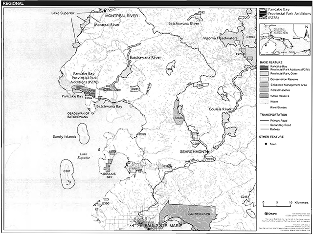
Enlarge Figure 1: Regional setting map of Pancake Bay Provincial Park
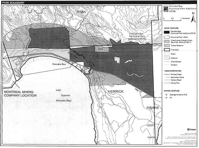
Enlarge Figure 2: Park boundary map
In addressing custodial management obligations to protect park values and ensure public health and safety, Ontario Parks will ensure that policy and Environmental Assessment Act requirements are implemented.
2.1 Environmental assessment
As part of the Ontario Ministry of Natural Resources (MNR), Ontario Parks is a public sector agency that is subject to the Environmental Assessment Act. Management of the recreation park will be carried out in accordance with legislation, policies and A Class Environmental Assessment for Provincial Parks and Conservation Reserves (OMNR 2005a).
3.0 Park features and values
The Pancake Bay Additions contain two Natural Heritage Areas (NHA): Gimlet Creek and Lake Superior Lookout.
3.1 Geological features
The Pancake Bay Additions incorporate significant remnants of the Nipissing Great Lakes beach bluff and a number of post-Nipissing beach bars, spits, and offshore bars. These narrow ridges of sand and fine gravel parallel the present shoreline up to several kilometres inland, and are separated by narrow depressions (swales) containing wetland vegetation. Such proto-Superior shore features are common to the eastern Superior shoreline, but they are particularly well developed and well-preserved in the Gimlet Creek area (Knudsen 1998; Kor 2001).
Bedrock in the park additions include mafic volcanic rocks, primarily basalt, cobble conglomerate, and brecciated felsic intrusive rocks. These were formed in the Keweenawan (Proterozoic or Late Precambrian) age. The Lake Superior Lookout contains the higher scarp face of the exposed cobble conglomerate outcrop. The conglomerate exposure is up to three metres high in this location. The layered sedimentary structures are evident in this ancient deposit. It likely represents the Copper Harbour Conglomerate, which is a sequence of post-volcanic sedimentary deposits formed after the late stages of mid-continental rifting. The conglomerate scarp is poorly consolidated and weathers easily as water seepage and freeze-thaw cycles breakdown the rock. This process of slow weathering has produced slopes of loose stony rubble and a more calcareous soil that is grown over by forest vegetation (Knudsen 1998; Kor 2001).
3.2 Biological features
Pancake Bay Additions lie within the Great Lakes St. Lawrence Forest. The proximity of this area to Lake Superior and the moderating affects of this result in some southern species occurring here, beyond their usual northern limits. Sugar maple and yellow birch upland forest stands include white spruce and patches of eastern hemlock. Older deciduous trees in these stands have epiphytic lichens on their course bark, such as lungwort. These lichens have been used elsewhere as indicators of good air quality. A number of uncommon plants occur in this area including Maidenhair Fern, Northern Holly-Fern and the provincially rare Braun’s Holly-Fern.
In the Gimlet Creek NHA, there are numerous raised beach ridge and swale formations that contain highly diverse vegetation communities in the wetland swales. The forest cover consists of small patches of black spruce in the swales, with white birch and balsam fir on the ridges.
Eastern white cedar lines the banks of the Pancake River as it flows through the additions. A series of three low waterfalls, each less than two metres high, occur within the upper reaches of the river, at the north end of the additions. The river is a clear, cold-water system that supports a native brook trout population.
3.3 Cultural setting
There has been no cultural heritage assessment of the Pancake Bay Additions.
Any future planning will be within the context of a provincial framework, A Topical Organization of Ontario History (OMNR 1974). In addition, updates and discussions with First Nations, other agencies and stakeholders may be carried out to identify cultural heritage values and features within the park and their significance. This information may be used to develop management guidelines to conserve and protect representative archaeological and historical values and features, or to provide direction for further research.
3.4 Recreation
The Pancake Bay Additions support a wide variety of outdoor recreation opportunities, including hiking, landscape viewing, exploring, fishing (on small rivers), and hunting. The park additions also offer opportunities for visitors to learn about the area’s natural and cultural heritage, including eastern Lake Superior geology and ecology, Great Lakes transportation, Aboriginal occupations, the fur trade, commercial fishing, timber harvesting, and mining. These heritage themes may be presented through self-guided trails, outdoor displays, literature, and the park host program for day-use and campground visitors.
The majority of the Pancake Bay Additions use is from tourists who are travelling the Highway 17 route along the Lake Superior coast line. This type of use is expected to continue.
4.0 Aboriginal use
The Pancake Bay Additions lie within the Robinson-Superior Treaty of 1850. The closest Aboriginal community is the Obadjiwan Aboriginal community, which is located 10 kilometres to the southeast, on the west side of Batchawana Bay.
Consultation regarding the boundary regulation of Pancake Bay Provincial Park Addition was conducted with the Batchawana, Garden River, Mississauga, Serpent River, and Thessalon First Nations, as well as the North Shore Tribal Council (OMNR 2000b).
First Nations have expressed interest in and have shared knowledge of the park and surrounding area. Aboriginal communities have used the area for hunting, trapping, fishing, gathering and travel. These uses may continue, subject to public safety, conservation and other considerations.
Any communications and cooperation between Aboriginal communities and the MNR for planning and operations purposes will be done without prejudice to any future discussions or negotiations between the government of Ontario and Aboriginal communities.
5.0 Stewardship policies
The removal, damage or defacing of Crown property, natural objects, relics, and artefacts is not permitted in the park additions (Provincial Parks Act).
Non-native species will not be deliberately introduced into the park. Where non-native species are already established and threaten park values (i.e. has become invasive), a strategy to control the species may be developed (OMNR 1992).
5.1 Terrestrial ecosystems
5.1.1 Vegetation
Harvesting
Past and recent logging for sugar maple and yellow birch prior to regulation disturbed parts of the park additions as evident by old resource access roads. Commercial forest operations are not permitted within the park additions. The harvest of non-timber forest products such as club moss, Canada yew, etc., will not be permitted (OMNR 1992).
New wild rice harvesting operations are not permitted.
There are no fuelwood cutting permits currently issued for the park. New permits will not be issued (OMNR 2000a).
Timber salvage and sunken log retrieval is not permitted.
Insects and disease
Insects and diseases may be managed where the aesthetic, cultural or natural values of the park are threatened (OMNR 1992). Control measures will follow guidelines established by the Ontario Ministry of the Environment (MOE) and MNR. Whenever possible, biological control measures will be given preference over the use of chemicals (OMNR 1992).
Fire
Pancake Bay Provincial Park Addition is located within the Great Lakes-St. Lawrence Zone for forest fire management. In accordance with existing provincial park policy and the Forest Fire Management Strategy for Ontario, forest fire protection will be carried out in the park as on surrounding lands (OMNR 2004a).
Whenever feasible, MNR's Forest Fire Management program will use techniques that minimize damage to the landscape, such as limiting the use of heavy equipment or limiting the number of trees felled during response efforts (OMNR 2004b).
5.1.2 Wildlife management
The Pancake Bay Additions are located within Wildlife Management Unit 36. The removal or harassment of non-game animals is not permitted (Provincial Parks Act).
Hunting
Sport hunting is permitted to continue in the park additions but not in the original park. Considerations of safety and conservation with respect to hunting may be made through future management planning, which would include public and Aboriginal consultation (OMNR 2000).
The Fish and Wildlife Conservation Act (1997) and the Migratory Birds Convention Act (1994) govern hunting within the park. The Ontario Hunting Regulations Summary contains regulations specific to this area. The harvest of bullfrogs or snapping turtles is illegal in provincial parks.
Bear management areas
The Pancake Bay Additions fall within one active bear management area (BMA): SS-36-006 (Figure 3). Existing commercial bear hunting operations are permitted to continue in the park additions. This activity may be subject to conditions identified during future management planning (e.g. the designation of nature reserve zones). Commercial bear hunting is not permitted within the the area of the previously regulated Pancake Bay Provincial Park.
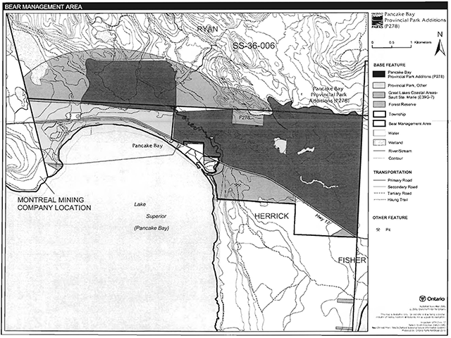
Enlarge Figure 3: Bear management areas map
New BMA licences will not be permitted (OMNR 2000a; 2003)
Trapping
The Pancake Bay Additions are included within two trap areas: SS-02 and SS-PL-01 (Figure 4). Trapping is not permitted within the original Pancake Bay Provincial Park boundary.
Existing commercial fur harvesting operations may continue where the activity has been licensed or permitted since January 1, 1992. New operations, including trap cabins and trails, will not be permitted (OMNR 2000a; 2003).
Transfers of active trap line licenses are permitted, subject to a review of potential impacts and the normal transfer or renewal conditions that apply.
5.1.3 Industrial resources
There are no existing mining claims within the park additions. There are no existing mining claims within park. The mining and surface rights on all lands within the park have been withdrawn from staking under the Mining Act (1990). Mineral exploration and mining are not permitted in the park.
Mineral exploration and mining are not permitted within the park. The mining and surface rights on all lands within the park have been withdrawn from staking under the Mining Act (1990). In accordance with Ontario’s Living Legacy Land Use Strategy, however, access in the park to mining lands (i.e. forest reserve(s) and mining patents) will be permitted for purposes of mineral exploration, development, or operations. Access will be planned in accordance with the requirements of the Environmental Assessment Act.
Sand and gravel was removed in the area of the additions associated with a logging road north of Highway 17. One abandoned gravel pit on the north side of Highway 17 was operated by the Ontario Ministry of Transportation (MTO). Aggregate extraction is not permitted in the park additions (OMNR 1992; 2000a).
5.1.4 Access and crossings
Access
The park additions are accessible by resource access roads north of Highway 17, Smith’s Road on the east side and Tower Road on the west (Figure 2).
Roads
The Trans-Canada Highway (Highway 17) runs along the south side of the Gimlet Creek portion of the additions. Several access roads branch off of Highway 17:
- Smith’s Road runs north along the west bank of the Pancake River;
- a road branching from Smith’s Road provides access to the Lake Superior Lookout;
- Tower Road provides access west of the park including the existing microwave tower;
- the gated Department of Fisheries and Oceans (DFO) road on the east side of the Pancake River was built by DFO to establish and operate a sea lamprey barrier on Gimlet Creek. This road does not permit public access;
- a logging road delineates the north-eastern boundary of the Gimlet Creek area; and,
- a gravel road, which traverses the original Pancake Bay Provincial Park provides access to a waste disposal site and a private land holding on the western boundary of the Lake Superior Lookout portion of the additions.
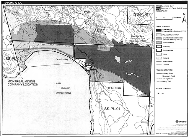
Enlarge Figure 4: Trap line areas map
Where existing resource access roads are essential for continued access beyond the park for forest management or recreation purposes, and alternative road access does not exist, or road relocation is not feasible, existing roads will continue to be available for access. Continued use will include maintenance and may include upgrades (OMNR 2004a).
Ontario Parks is not responsible for the maintenance or upgrade of any resource access roads within the park.
Any proposed development, maintenance or upgrading of existing roads must meet all Environmental Assessment Act requirements.
Utility corridors
There are no utility corridors in with the Pancake Bay Additions; however, a hydro line running parallel to Highway 17 is located to the south of the Gimlet Creek portion of the additions.
Maintenance of this existing utility line must adhere to the regulations set out under the relevant acts, such as the Environmental Assessment Act, the Canadian Environmental Protection Act (1999), and the Pesticides Act (1990). Maintenance activities will not impact negatively on the features and values being protectedwithin the park additions.
All public utilities (e.g. gas pipelines, transmission lines, communications towers) must avoid park lands wherever possible. New utility corridor crossings may be necessary to maintain essential public services (OMNR 2004a).
Any future utility corridors proposed through the park, where park lands are unavoidable, will be reviewed on a case-by-case basis. Protection of park features and values will be a priority and all requirements of the Environmental Assessment Act will be met.
Recreational trails
New trails (e.g. hiking) may be developed if the need arises. Any proposed development within the park is subject to Environmental Assessment Act requirements.
Canoe Routes: There are no canoe routes within the Pancake Bay Additions.
ATV and Snowmobile Trails: ATV and snowmobile use is authorized only on Smith’s Road and Tower Road in the Pancake Bay Additions.
Hiking Trails: There are approximately 12 kilometres of trails which connect with the existing park and the park additions. Portions of these trails use parts of previously established resource access roads. The Lookout Trail leads to viewing decks located at the Lake Superior Lookout, which provides views of the Pancake River valley, Gimlet Creek wetlands, and Lake Superior.
5.1.5 Adjacent land management
Forestry
The Algoma Forest Management Unit, is adjacent to the park. The forest management plan (FMP) for this forest will be reviewed and renewed as required. Continuance allocations available on the Smith’s Road will be reviewed during the planning stages of the next FMP.
Provincial parks
Batchawana Provincial Park: This 169 hectare recreation class park is located at the mouth of Batchawana River, approximately two kilometres to the east of the Pancake Bay Additions.
Batchawana River Provincial Park: This 2,684 hectare waterway class park is situated to the north-east of the Pancake Bay Additions. Batchawana River Provincial Park includes a variety of features from narrow bedrock controlled valleys to widenings with river meanders. The numerous rapids and falls and small islands attract canoeists with advance river travel skills.
Sandy Islands Provincial Park: Two islands and offshore shoals form this 2,477 hectare nature reserve class park. This park occurs offshore to the southeast in Lake Superior at the mouth of Batchawana Bay and can only be seen on very clear days.
Forest reserve
Forest reserves (FR) are areas where protection of natural heritage and special landscapes is a priority. Policies for FRs are similar to the policies for new conservation reserves, except that some resource use such as mining and related activities can take place with appropriate conditions. Commercial forest harvest, new hydroelectric power development, and peat extraction will not be allowed, but most other resource and recreation uses will be permitted, provided they are consistent with the features and values being protected (OMNR 1999).
Pancake Bay Forest Reserve (F278) was identified to the east of Pancake River in Herrick Township. This FR's active mining claim was not included in the regulated area of the park. As described in the proposed strategy for FRs (OMNR 2005b), this FRs designation will be removed from all mining lands at the site and will be redesignated as a part of the Batchawana Bay- Carp Lake Raised Delta Enhanced Management Area (EMA).
Enhanced management areas
EMA is a land use category that was established to provide land use direction in areas that contain special features or values (OMNR 1999). There are two EMAs in the Pancake Bay area.
Great Lakes Coastal Areas EMA (E39g) in the Pancake Bay area includes scenic and rugged topography. A wide range of recreational activities occur here, including hunting, fishing, camping, and nature appreciation. The majority of lands here will be managed to protect sensitive ecosystems and outstanding beauty, and to complement recreation and tourism in the area. Land within the EMA will not be sold for cottage development. New road access will be discouraged. Batchawana Bay- Carp Lake Raised Delta EMA (E280n) formed when the “Nipissing” glacial great lake existed here before the current levels and drainage of the Great Lakes were established. A steep bluff was created here 5,000 years ago, at the Nipissing water level, adjacent to the Batchawana River. This delta on the bluff is from the much older Minong and post-Minong lake stages of the Superior basin, which formed when glacial ice stood along its north shore. A wide range of recreational activities occur here, including hunting, fishing, camping, and nature appreciation. Lands will be managed here to conserve the above noted natural heritage features, and to complement recreation and tourism in the area. New road access and aggregate extraction will be discouraged.
General use areas
Highway 17 North Corridor General Use Area (G1907): This General Use Area encompasses 10,600 hectares of Crown land. The area is comprised of a narrow corridor of land that is bound by the shoreline of Lake Superior and a line one kilometre east of Highway 17 North. Development in this area has generally been directed towards transportation, recreation, and tourism. The area is extensively used by local residents and is also considered a prime tourist attraction for the Sault Ste. Marie area. The coastal portions of this General Use Area are located within the Great Lakes Heritage Coast Signature Site. The general land use intent for this area is for transportation and recreation, with special emphasis on the protection of the scenic landscape along this route (OMNR 2004).
Batchawana General Use Area (G1908): This General Use Area encompasses 178,151 hectares of Crown land. The intent for this General Use Area is to manage the area for public recreation. All other land uses will be permitted in this area; however, site specific restrictions may be imposed on activities where Crown land recreational facilities are being developed around critical fish habitat (OMNR 2004a).
5.1.6 Land disposition
New land disposition for the private use of individuals or corporations will not be permitted (OMNR 1992; 2000a).
Land use permits, licenses of occupation, unauthorized occupations
The DFO holds a vesting order on a small area at Gimlet Creek near the confluence of the Pancake River, where a sea lamprey barrier was constructed. These lands are to return to the province and could be added to the park once the lamprey work has been completed, and all structures would be removed from site. Presently, these lands and a road leading to the site are excluded from the park boundary.
There are no land use permits (LUP) for private or commercial use, nor are there any licenses of occupation or known unauthorized occupations within the Pancake Bay Additions.
Boat caches
There are no authorized boat caches within the park addition. Boats are not permitted to be left unattended in the park without written permission from the superintendent under the authority of the Provincial Parks Act.
5.2 Aquatic ecosystems
Sustaining quality water resources is integral to the protection of park and adjacent land values. The MOE enforces applicable legislation and regulations for water quality.
5.2.1 Water management
There are no hydro developments, water control structures, or diversions within the park additions. New commercial hydroelectric developments will not be permitted (OMNR 2000a).
5.2.2 Fisheries management
The Pancake Bay Additions contain native brook trout populations, as well as populations of introduced salmon and rainbow trout in the Pancake River (Kershaw 2002; Morris and Knudsen 2002). Fisheries management activities will be aimed, wherever possible, at the maintenance and enhancement of native, self-sustaining fish populations (OMNR 1992).
As discussed previously, the DFO has established a sea lamprey barrier on Gimlet Creek near the confluence with the Pancake River for research purposes (Kershaw 2002).
Sport fishing
Sport fishing is permitted within the park. This activity is governed by legislation and regulations in the Fish and Wildlife Conservation Act (1997) and the Fisheries Act (1985). The Recreational Fishing Regulations Summary contains details on the applicable regulations for this area.
Commercial fishing
There are no commercial fishing operations within the boundary of the Pancake Bay Additions. New operations will not be permitted (OMNR 2004a).
Commercial baitfish harvesting
Ryan and Herrick townships (SM-00-48 and SM-00-67) are currently not allocated for baitfish harvesting (Figure 5). New baitfish licenses will not be permitted; however, Ryan and Herrick townships may be allocated for baitfish harvesting if this activity occurred since January 1, 1992 (OMNR 2000a; 2003).
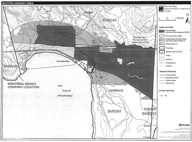
Enlarge Figure 5: Commercial baitfish harvesting map
Fish stocking
The stocking of native fish species may be considered through park management planning, with full public and Aboriginal consultation. Non-native fish species will not be deliberately introduced into park waters (OMNR 1992).
Sewage disposal lagoon
In Ryan Township, to the west of Pancake River, there is a 2.8 hectare park sewage lagoon. The site will be fenced, appropriate signs will be posted, and the lagoon will be brought up to standard in accordance with sewage disposal requirements.
6.0 Operations
6.1 Recreation management
Infrastructure on the lands of the park additions will be managed in concert with the existing park. Future planning, with full public and Aboriginal consultation, will review direction on motorized and non-motorized recreation uses.
6.1.1 Motorized recreation
Motorboats
Water bodies within the Pancake Bay Additions are too small to support motor boat use -thus motor boats are not permitted.
Aircraft
Aircraft landings are not permitted in the Pancake Bay Additions (OMNR 2004a).
Snowmobiles
Snowmobile use will be allowed on Smith’s Road and Tower Road. No other trails are authorized in the park additions.
Proposals for new trails may only be considered through future planning with public and Aboriginal consultation (OMNR 2000a).
Off-trail snowmobile use is not permitted within the park.
All-terrain vehicles (ATV)
ATV use will be allowed on Smith’s Road and Tower Road. No other trails are authorized in the park additions.
Proposals for new trails may only be considered through future planning with public and Aboriginal consultation (OMNR 2000a).
6.1.2 Non-motorized recreation
Camping
There are currently no developed campsites, or camping use within the Pancake Bay Additions. If there is an identified need, new campsites may be considered (OMNR 2004a). Infrastructure will be permitted in order to protect park features and values in response to use, environmental deterioration and environmental protection requirements. Any proposed development in the park must fulfill the requirements of the Environmental Assessment Act.
Hiking
Hikers and fishermen use existing trails and open resource access roads within the park addition. Existing hiking trails may be permitted to continue unless such trails threaten park features and values, create user conflicts or raise safety/liability issues.
If there is an identified need, the development of new hiking trails may be considered. Trail infrastructure to protect park values and features will be permitted. Any proposed development within the park is subject to Environmental Assessment Act requirements.
Canoeing/kayaking
Pancake River, Gimlet Creek, and other water bodies in the Pancake Bay Additions are generally unsuitable, too shallow for canoeing or kayaking. Existing uses may continue, unless park values are threatened (OMNR 2004a). Infrastructure to protect park features and values may be permitted and developed in response to use, environmental deterioration and environmental protection requirements.
6.1.3 Emerging recreation uses
There are emerging recreational uses for which there is limited or no policy to deal with their management (e.g.adventure racing, geocaching). The park superintendent will use legislation, policy, and guidelines which are in place to manage emerging uses.
6.2 Development
The only existing park infrastructure within the Pancake Bay Additions are the Lookout Trail and viewing areas and a sewage lagoon. Infrastructure to protect park features and values may be permitted and developed in response to use, environmental deterioration, and environmental protection requirements. Any proposed development within the park is subject to the Environmental Assessment Act.
6.3 Commercial tourism
There is no commercial tourism infrastructure within the park additions. New commercial tourism facilities may be considered where they would be consistent with park policy (OMNR 2004a). Any development must meet the requirements of the Environmental Assessment Act.
7.0 Cultural resources
An assessment of the cultural resources specific to the Pancake Bay Additions has not been conducted. The management of any cultural values within this park will be directed toward protection and heritage appreciation (OMNR 1992).
8.0 Heritage education
Natural heritage education (NHE) will be managed in accordance with the Pancake Bay Provincial Park Management Plan and the Pancake Bay Additions Minor Amendment. A NHE plan may be prepared for the entire park in accordance with management direction for heritage appreciation.
The park, park additions, and area themes will be highlighted primarily through self use information and facilities.
Heritage education themes include:
- geological features that portray ancient environments which are associated with metamorphic and volcanic rocks of the Superior Geological Province;
- geomorphological features that are represented in this portion of the ancestral and modern eastern shores of Lake Superior;
- plant and animal communities of the transition Great Lakes St. Lawrence and Boreal forests;
- conservation and family camping and day use.
Literature and other supporting information may be developed to describe the park in the context of Ontario’s provincial park system. Boundary limits, significant heritage features and permitted uses of the waterway park may be included in park literature. Park visitors may be informed about the sensitivity and significance of park values.
9.0 Research
Scientific research by qualified individuals which contributes to the knowledge of natural or cultural history, or to environmental or recreational management, may be encouraged in the park. Ontario Parks will encourage institutions, such as universities, to undertake research projects.
All research programs will require the approval of Ontario Parks and are subject to park policy and other applicable legislation. Any materials removed from the park will remain the property of Ontario Parks.
Approved research activities and facilities will be compatible with the park’s protection objective. Any site which is affected by research will be rehabilitated as closely as possible to its original state. Environmental Assessment Act requirements will apply.
10.0 References
Canadian Environmental Protection Act, 1999.
Environmental Assessment Act, 1990.
Fisheries Act, 1985.
Fish and Wildlife Conservation Act, 1997.
Kershaw, W.L., 2002. Recreation Assessment Inventory Report- Pancake Bay Provincial Park Addition P278.
Knudsen, R., 1998. Pancake Bay Life Sciences Study.
Kor, P., 2001. Earth Science Draft Checksheet. Microsoft Access Database File.
Migratory Birds Convention Act, 1994.
Morris, E.R., and R.D. Knudsen, 2002. Pancake Bay Provincial Park Addition (OLL P278) Life Science Checksheet.
Ontario Ministry of Natural Resources, 1974. A Topical Organization of Ontario History. Historic Sites Branch Division of Parks.
Ontario Ministry of Natural Resources, 1988. Pancake Bay Provincial Park Management Plan.
Ontario Ministry of Natural Resources, 1992. Ontario Provincial Parks: Planning and Management Policies.
Ontario Ministry of Natural Resources, 1999. Ontario’s Living Legacy Land Use Strategy.
Ontario Ministry of Natural Resources, 2000a. Ontario’s Living Legacy Land Use Strategy Policy Clarification.
Ontario Ministry of Natural Resources, 2000b. Public and Aboriginal Consultation Documentation Form - Ontario’s Living Legacy Protected Area Boundary Refinement Review- Pancake Bay Provincial Park Addition.
Ontario Ministry of Natural Resources. 2003. Directions for Commercial Resource Use Activities in Provincial Parks and Conservation Reserves. 5 pp.
Ontario Ministry of Natural Resources, 2004a. Crown Land Use Policy Atlas.
Ontario Ministry of Natural Resources. 2004b. Forest Fire Management Strategy for Ontario. Aviation and Fire Management Branch.
Ontario Ministry of Natural Resources, 2005a. A Class Environmental Assessment for Provincial Parks and Conservation Reserves.
Ontario Ministry of Natural Resources, 2005b. Summary of Proposed “Disentanglement” Strategies for Recommended Protected Areas and Pre-existing Mining Lands.
Pesticides Act, 1990.
Provincial Parks Act, 1990.
Appendix A: Background information
- Name: Pancake Bay Provincial Park Additions
- Classification: Recreation
- Ecoregion/ecodistrict: 5E-13 (Batchawana)
- OMNR administrative region/district: Northeast- Sault Ste. Marie
- Total area (ha): 1,233
- Regulation date and number: Dec 2002 (O. Reg. 311/02)
Representation
Earth science
The Pancake Bay Additions complete the representation of sequentially formed lacustrine features and processes from the present beach to the sea-cliffs and caves in the bedrock terrain. The Lake Superior Lookout natural heritage area portion of the additions has excellent examples of exposed rocky outcrops comprised of cobble conglomerates formed over one billion years ago (Morris and Knudsen 2002).
The Gimlet Creek natural heritage area is located north of Highway 17 and east of the Pancake River. The area in the south displays numerous raised beach ridges of ridge and swale formations containing highly diverse vegetation in the wetland swales. Further north the topography rises gradually from formations of cobble conglomerates, veins of feldspar and basalt. The upper portion of Gimlet Creek has created three sets of falls exposing conglomerates and mixed feldspar and basalt rock ledges. The ancient beach ridges date back 10,000 years to the last glaciation. The cobble conglomerates date back one billion years and the feldspar deposits are locally significant (Morris and Knudsen 2002).
Life science
The Pancake Bay Additions are located in Northeastern Ontario in Batchawana Ecodistrict 5E-13. A tolerant hardwood forest of sugar maple and yellow birch covers most of the land base, however, there are mixed wood lowland terraces between ancient beach ridges on the east half of the addition, and small patches of black spruce in the swales between white birch and balsam fir on the ridges at the Gimlet Creek. The site is essentially intact, although selective and shelterwood harvesting of sugar maple and yellow birch stands has occurred in the past.
The Pancake River flows south through the center of the addition. At the north end there is a series of three low falls (less than two metres high) that attract fishermen each spring and fall during rainbow trout and pacific salmon runs. The river also supports a native brook trout population.
Cultural resources
An investigation and analysis of the cultural resources specific to the Pancake Bay Additions has not been completed at this time.
Recreation and tourism
The Pancake Bay Additions can support a wide variety of outdoor recreation opportunities in an attractive mixed forest setting including hiking, landscape viewing, exploring, fishing and hunting.
Inventories
| Survey level | Earth science | Life science | Cultural | Recreational |
|---|---|---|---|---|
| Reconnaissance | Kor 2001 | Morris and Knudsen 2002 | Kershaw 2002 |
Footnotes
- footnote[1] Back to paragraph Transfers include situations where a license is surrendered with a request that it be immediately reissued to another individual or organization that is assuming an existing operation. Trap cabins are considered part of a trapline and would be transferred with the trapline for the purposes of trapping. If a trapline license is revoked or surrendered, all portions of the registered line within the park will be rescinded from the legal description of the trap line (OMNR 2003).