Polar Bear Provincial Park Management Plan
This document provides policy direction for the protection, development and management of Polar Bear Provincial Park and its resources.
Minister’s approval statement
Many Ontarians think of Algonquin as Ontario’s largest Provincial Park. In fact, it is not. Some 1,000 kilometres northwest of Algonquin, along the salt water coast of Hudson and James Bays, is a vast land of polar bear, whales, caribou, walrus, ptarmigan and tundra. Here lies a park more than three times the size of Algonquin - Polar Bear Provincial Park. Spanning 24,000 square kilometres, Polar Bear is among the world’s largest and most significant parks. It is truly an outstanding provincial treasure.
Master planning for this park began with the park’s formal designation in 1970. The ten years required to finalize this plan itself reflects the complexity and significance of this resource.
I am indebted to those many individuals and groups who have helped to build this plan. Native peoples, scientists, wilderness enthusiasts, conservation organizations and others have generously taken time to share their comments and constructive criticisms regarding various preliminary proposals for Polar Bear. A major challenge of this planning exercise has been to integrate traditional use of the park area by native peoples with development and management strategies which will ensure the integrity of this sensitive environment is not compromised. I am confident that we have met the challenge.
No park can be all things to all people. This master plan recognizes that it may be necessary to limit the number of people within the park at any one point in time because of its fragile landscape. However, Polar Bear will offer to wilderness enthusiasts outstanding opportunities to camp, canoe, hike, fish and to study natural history. Limited hunting for migratory waterfowl will continue at two restricted sites. Polar Bear will also continue to be an outstanding natural laboratory for scientific research.
In accordance with The Provincial Parks Act, sections 1d and 7a, I am pleased to approve the Polar Bear Provincial Park Master Plan as the official policy for the future development and management of this park. A review of this plan will be made in 1985.
Honourable James A.C. Auld
Minister
March, 1980
Introduction
In August, 1977 the Polar Bear Provincial Park Background Information and Planning Proposal were released to the public by the Ontario Ministry of Natural Resources. At that time the Ministry solicited public response especially to the Planning Proposal document.
Public feedback came from individuals and groups in the form of written submissions and verbal comments made at public information centres which were operated at Moose Factory, Moosonee and Toronto and at various Ministry meetings with representatives of the Indian Bands most directly affected by the park – Attawapiskat, Fort Severn and Winisk. This input was summarized in Polar Bear Provincial Park Public Participation. A Summary of Comments and released to the public in April, 1979. Many of the recommendations from that publication have been incorporated into the master plan, which is the official policy for the future planning and management of the park.
The following section outlines the aims or the program which led to the production of this master plan.
Master planning program objectives
The objectives or the Master Planning Program were as follows.
- To establish an overall plan for the tong-term development and management of the park under existing legislation and government policies.
- To identify and delineate the major resources of the park as they relate to the human and natural characteristics or the area and as a sub-objective to recognize the important international value of the migratory wildlife resources that utilize the park as an integral part or their life history.
- To establish a zoning plan which will favour protection of resources over use.
- Within the constraints implied by the preceding item, to designate areas for the development of visitor facilities in relation to character, scale, visitor demand and the capabilities of the area in question
- To provide the basic guidelines relating to the circulation system, water access routes, and trails for both visitors and park stall.
- To provide the basic guidelines relating to the location or administration and operational facilities.
- To guide the development and management of the park, with due consideration to the interrelationship between developments inside the park and factors operating in the surrounding area, and particularly to recognize traditional native people’s concerns as they relate to the utilization to the park and its resources.
- To involve the public as a participant in the overall master planning program.
1.0 Broad policy
With public assistance the Ministry of Natural Resources has developed policy intended to insure in perpetuity the stature of Ontario’s premier wilderness park.
1.1 Goal
The goal for Polar Bear Provincial Park is threefold:
- To protect its environment for the benefit of present and future generations from significant alterations by humans.
- To provide quality, low-intensity wilderness recreational opportunities.
- To provide opportunities for scientific research complementary to Ministry of Natural Resources programs.
Proviso: The foregoing notwithstanding, Polar Bear Provincial Park policy will continue to accommodate the traditional gathering activities of native people without unduly compromising the wilderness integrity or the park.
1.2 Statement explaining the goal
Environmental
Wilderness canoeing and fishing, backpacking, and the study and appreciation of natural and cultural features are the prime recreational activities. Limited waterfowl hunting at the mouth or the Sutton River and Shagamu River will be allowed.
The emphasis will be placed completely on unmechanized activities with very few exceptions. Exceptions will include guide-operated power boats in the Sutton River and Winisk River access zones and along the coast, as well as aircraft landing at access zones. Environmental carrying capacities for visitors will be established at access zones in order to help ensure a quality wilderness experience and to protect the environment against overuse.
Polar Bear Provincial Park is or scientific importance particularly with regard to permafrost, arctic tundra, waterfowl, shore birds and polar bears. Park policies will allow for scientific research of a mainly nondestructive nature.
The implications or the proviso are discussed in the section dealing with “Native People and Polar Bear Provincial Park”.
1.3 Park classification
Polar Bear Provincial Park is classified as a wilderness park and will be managed and protected according to directions provided in the Ontario Provincial Parks Planning and Management Policies and The Provincial Parks Act and its regulations.
Some departures from the initial objectives of the Wilderness classification will be made to accommodate the very special circumstances of Polar Bear Provincial Park. For example, waterfowl hunting will be allowed at points in Access Zones 2 and 4 because of the precedent of this activity at these locations and because of the important relationship of the native people to the management of the park. Any hunting by non-native people at these access zones will be done through the goose camp operations.
Such exceptions should in no way be construed as any sort of precedent with regard to other provincial wilderness parks in Ontario.
1.4 Park zoning
Polar Bear Provincial Park will have five access zones, five nature reserve zones, four historical zones and three wilderness zones established as shown in Figure 1. A more sophisticated zoning system may evolve however with more detailed knowledge of the park’s environment.
2.0 Access zones
2.1 General
Access zones will be provided at five locations within Polar Bear Provincial Park - Brant River, Shagamu River, Site 415, Sutton River and Winisk River The five zones occupy a total of 2,064 ha (5,100 acres). Facilities and services, including public information and interpretation will be provided as necessary at each access zone. The park’s operational headquarters at Winisk, outside the park boundaries, will be the major location for services and supplies. The Ministry district office in Moosonee will be responsible for most of the park administration work.
2.2 Activities and facilities
Activities and facilities will be directed toward a wilderness type use of the natural features of the park. Only facilities and activities which are related to the use of these natural features and which will cause minimal damage to the park environment will be allowed.
Activities involving mechanized vehicles will not be permitted except in the case of motor canoes used by native guides at the Sutton River and Winisk River access zones and along the coast.
Except during emergencies, aircraft landings may be made only at access zones
Camping facilities will be available by reservation only. First aid will be available at all staffed access points (probably Brant River and Site 415) and at the park office at Winisk.
2.3 User capacities
The total number of visitors at each access zone on a reservation system basis will be restricted to designated quotas. These will be revised from time to time in the light of operating experience. Facilities and services will be kept to a minimum and these will be provided almost exclusively at access zones. Length of stay and party size will also be regulated if required.
No overflow use will be permitted in the park. Once visitor capacities are reached in any zone, no further entry will be permitted until use again drops below the capacity level. Park access zones and other park areas will be monitored at the end of each visitor season to ensure that quotas have been accurately set so that no significant site deterioration will be experienced during any one year.
Figure 1: Zones
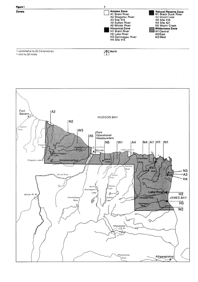
Enlarge this map of zones within Polar Bear Provincial Park (PDF)
It may become necessary in the future to establish separate quotas for residents and non-residents to ensure that residents have access opportunity to their resource. The essential concern is that should both resident and non-resident demands increase and the park’s defined capacity cannot accommodate both, an overwhelming disparity in proportion between residents and nonresidents could result in a situation whereby residents might be denied access while non-residents saturate the park.
Aircraft landing in the park will be authorized by Ministry-issued landing permits only.
Each visitor or group entering the park will require a park travel permit indicating the point of entry, the route and mode of interior travel, the point of exit, and the duration of the stay. This permit will be issued for a fee at Moosonee District Office and at the manned access zones.
No pets will be allowed in the park except that retrievers may be used at the Shagamu and Sutton goose camps. Garbage and refuse must be brought to designated collection sites from all park areas by visitors.
2.4 Resource management
Resource management will be directed toward low-intensity, high-quality recreational experiences and toward the maintenance of a quality wilderness environment to provide those experiences.
Fishing will be managed in accordance with the Ontario Fishery Regulations (Division 24 and 25). Artificial lures only will be permitted so as to prevent the possible introduction of exotic species into park ecosystems. Stocking will not be allowed. The park fishery will be managed so as to maintain fishing quality and quantity.
Waterfowl, sharp-tailed grouse, ptarmigan and snipe hunting will be permitted only if accompanied by a guide registered with one of the camps al the Shagamu River and Sutton River access zones and in accordance with the Game and Fish Act and the Migratory Birds Convention Act and its regulations.
Firearms will be allowed only at the Shagamu River and Sutton River access zones for use by clients of the Cree-operated goose camps. Sealed firearms for protection from polar bears may be carried elsewhere in the park only with the written consent and according to the stipulations of the District Manager at Moosonee. If this policy results in problems, areas of heavy polar bear concentration will be zoned off-limits to park visitors during such periods of high bear density.
Environmental impact/quality monitoring will be carried out at access zones and elsewhere in the park on a regular basis, where possible with the advice and assistance of the Ministry of the Environment.
2.5 Visitor services
Visitor Services in Polar Bear Provincial Park will provide visitors with knowledge or the park’s environment management policies, and facilities.
Information concerning the park will be provided in Ministry publications and park brochures, by staff at Queen’s Park, regional and district offices, park headquarters, and at access zones. The media will be used to keep the public up-to-date concerning the park and its management policies.
The communications effort will be directed toward improving visitor enjoyment and especially the understanding of the park including its environmental fragility and human carrying capacity. Particularly sensitive localities will not be identified in visitor services material. Other information for prospective users will stress visitor safety and the challenges of camping in a subarctic/arctic region. Park and other Ministry of Natural Resources publications and limited exhibit materials will be available at stalled access zones, the park headquarters at Winisk and departure points such as Moosonee. The interpretive component of the visitor services package for Polar Bear Provincial Park will be emphasized at Moosonee District Office and in certain media productions (which may be used elsewhere) such as movies, slide programs exhibits and publications. Much of the content of such material will be produced to meet the needs of vicarious users.
2.6 Research
Ministry of Natural Resources policy for research in provincial parks will guide the research interests of the scientific community in Polar Bear Provincial Park. Any detailed research applications which promise to help with the park’s management and operational problems and/or help increase the Ministry’s knowledge of the resource will be considered in light of research requirements, priorities and various other criteria outlined in the Polar Bear Provincial Park research plan. Successful applicants will be required to fulfill certain contractual obligations regarding such things as specimen collections and final reports.
Basic laboratory facilities and limited accommodation will be made available to approved research programs at Site 415 Access Zone.
3.0 Wilderness zones
3.1 General
The three wilderness zones are mainly dedicated to the environmental protection (from interference by man) of large tracts of unimpaired wild land for low impact wilderness recreation and scientific purposes. They contain 2,392,649 ha (5,912,300 acres). The wilderness zones provide retreats in which visitors may enjoy the benefits of solitude and challenge derived from an undisturbed natural landscape. They maintain the diversity of landforms, habitats and species, providing benchmark areas from which to evaluate our understanding and the management of our environment.
Specifically, these vast zones will be protected for environmental and scientific purposes, in addition to being available for appropriate recreational pursuits such as camping, canoeing, hiking, nature study, and photography.
The zones include: some of the most temperately located continuous permafrost and arctic tundra in the world; the world’s southernmost active nesting colony of snow geese; a number of species of birds which nest nowhere else in Ontario and some of the best caribou habitat in the province.
In addition to the relevant sections of the policy statements mentioned under Access Zones, the following specific policies will apply to the wilderness zones.
3.2 Activities and facilities
When and where necessary, primitive campsites, portage markers and earth pit toilets will be established to meet minimum requirements. A system of safely and unobtrusively marked hiking trails will be developed along some of the numerous beach ridges. Environmental monitoring of these trails will be started as soon as they are located, so that any deterioration resulting from overuse may be detected as soon as possible the trails rehabilitated, and reoccurrence of the problem avoided.
In addition to pertinent sections from Transport Canada directives (see Appendix) the right of animals to range unmolested by aircraft or any other sort of human interference in the park will be enforced. This policy will be stressed in publications and other park-related media. If additional controls become necessary, they will be devised under the authority vested in the Minister of Natural Resources in The Provincial Parks Act (item 17).
3.3 Land-uses adjacent to the park
Anything man-made capable of significantly altering the natural environment of Polar Bear Provincial Park, will be kept so far away from the park that its effects will not be of any significance. The effectiveness of such regulation will depend upon periodic environmental monitoring throughout the park’s natural systems. The importance of this policy will be identified in the Moosonee District Land-Use Plan so that any new developments in the northern section of the Hudson Bay Lowland will not adversely affect Polar Bear’s environment. In addition, many existing Federal and Provincial statutes and regulations such as the Environmental Assessment Act and the Environmental Protection Act will help to provide control over land-use adjacent to the park.
Should offshore oil explorations prove successful, the subsequent extraction and transportation of this resource might have deleterious effects upon Polar Bear Provincial Park. In the face of such developments, careful evaluations of potential threats to the park environment will be required before any decision can be made to go ahead with such projects.
The Government of The Northwest Territories and the Federal government will be requested to develop management policies for the offshore islands (along all the park coastline from the high tide mark to a distance out to sea of 15 km) which will be consistent with those of the Polar Bear Provincial Park Master Plan.
4.0 Nature reserve zones
4.1 General
The nature reserve zones in Polar Bear Provincial Park total 218,595 ha (540,160 acres). Their purpose is to protect unimpaired wild land from human interference for scientific and recreational purposes. These zones are essential because they protect a diversity of landforms, habitats and species representative of the sub-arctic and arctic sections of our province. The five proposed zones are as follows.
Nature Reserve Zone 1 (Black Duck River)
Zone 1 comprises the complete watershed of the Black Duck River and a coastal strip from Cape Lookout to Hook Point. It is one of the most interesting and sensitive ecological areas in Polar Bear, as it includes: one of the southernmost regions of permafrost in the park and possibly in the Northern Hemisphere; many vegetation types including a good representation of ecotonal areas and the park’s most arctic plant elements; nesting areas of arctic breeding birds which occur nowhere else in Ontario, including a substantial section of the snow goose nesting colony; important caribou range, and part of the area of highest polar bear concentration in Ontario. In addition, much of the zone includes good examples of freeze-thaw phenomena and emergent coastline features such as polygonal patterned ground and successions of recently uplifted coastal beach ridges, offshore bars, recurved spits, and tidal flats.
Nature Reserve Zone 2 (Wood Creek)
Zone 2 is a transection from the Hudson Bay coastline in the Wood Creek region inland to forested areas. It includes a series of parallel raised beaches representative of ancestral shorelines of the southern coast of Hudson Bay.
Nature Reserve Zone 3 (Site 416)
A few hundred yards south of Site 416, adjacent to the west side of the Mid-Canada Line road is a gravel pit with a large deposit of blue mussel (Mytilus edulis) shells. The shells were largely restricted to the intertidal regions of the Tyrrell Sea, and so are of considerable scientific importance in providing material for accurate carbon 14 dating of coastal emergence.
Nature Reserve Zone 4 (Site 421)
Zone 4 is the old Mid-Canada Line Site 421, located in a lichen-heath forest tundra region. Unlike the 415-416 complex, the site has been virtually undisturbed since the Mid-Canada Line operations ceased in 1965. It should provide interested parties with an opportunity to study the reaction of the natural environment to a firmly dated physical disturbance of considerable magnitude.
Nature Reserve Zone 5 (Wachi Creek)
The Wachi Creek Nature Reserve Zone encloses the only obvious place in the park where Precambrian rocks obtrude through Paleozoic limestone. Vegetation here reflects this anomalous bedrock condition.
4.2 Policies
In addition to the relevant sections of the policy statements mentioned under Access Zones, policies for nature reserve zones will be identical to those for wilderness zones except for the following provisions.
No camping will be allowed in nature reserve zones except in connection with temporary research activities. No fishing will be permitted in Nature Reserve Zone 1.
Researchers must comply with park rules; however special provisions for access or motorized equipment may be made where reasonable alternatives do not exist. The policy and procedure for research in provincial parks requires that district, regional and main offices approve research projects and guidelines.
Anyone visiting Polar Bear Provincial Park should have access to all its areas provided that their presence does not involve disturbance to animal life or danger to themselves. Even in the latter situation discretely conducted research projects may be possible with the District Manager’s permission.
5.0 Historical zones
5.1 General
The purpose of historical zones in Polar Bear Provincial Park is to protect areas of archaeological and historical significance for scientific and recreational purposes. The historical zones comprise 121 ha (300 acres).
Historical Zone 1 (Brant River)
The Brant River Historical Zone encloses one or the few acknowledged prehistoric sites within the park. It was the first prehistoric site to be discovered within the Hudson Bay Lowland.
Historical Zone 2 (Lake River
The Lake River Zone contains the remains of a Hudson’s Bay Company outpost which existed from 1929 until 1967.
Historical Zone 3 (Opinnagau River)
The area a t the mouth of the Opinnagau River was the site of the Hudson’s Bay Company and Revillon Frères Trading Company outposts which were in operation during the second and third decades of this century.
Historical Zone 4 (Site 415)
This zone contains the remains of the most important Mid-Canada Line base within the park. The construction and operation period was from 1955 to 1965.The zone also contains cache pits which are possibly of prehistoric age.
5.2 Policies
In addition to the relevant sections of the policy statements mentioned under Access Zones, policies for historical zones should be identical to those for the wilderness zones except that no camping will be allowed.
Historical zones in the park may be researched in accordance with provincial park research policies. No restoration or reconstruction of historical facilities will be undertaken in Polar Bear Provincial Park, however, existing features may be maintained.
6.0 Native People and Polar Bear Provincial Park
Recent archaeological work by Irving and Tomenchuck (1972), and Pollock and Noble (1974) suggests that people with a lifestyle similar to the traditional Cree have lived in what is now Polar Bear Provincial Park virtually from the time of its emergence from the Tyrrell Sea until the present.
It is intended that native people in the communities adjacent to the park (Attawapiskat, Fort Severn, and Winisk) will benefit from the income opportunities provided by the recreational and other uses of the park in a way consistent with the protection of the environment and the maintenance of a high quality wilderness experience.
Native interest will be of prime importance, whenever there is no conflict with the goal statement, as for example in guiding and working as park employees. The priority claim to such consideration by nearby native residents is recognized as stronger than the claims of native people further afield and other Ontario residents in general.
Local native people will continue their traditional activities such as subsistence hunting, fishing, trapping, and non-commercial gathering of other wild commodities under guidelines set by the Ontario Ministry of Natural Resources. Such guidelines will ensure that these activities are not expanded or extended, and that there is recognition and commitment by both the native community and the Ministry of Natural Resources to reduce or terminate the activity when any significant damage to the resource is shown or anticipated. For example, wildlife surveys have been carried out by the Ministry of Natural Resources and the Canadian Wildlife Service for many years on a number or species in Polar Bear Provincial Park. This work will continue and perhaps will be augmented so that population change can be monitored and acted upon should there be any indication that a species is getting into difficulty.
The Ministry of Natural Resources will negotiate with the appropriate Indian bands regarding the possibility of designating the Brant, Shagamu and Sutton rivers as off-limits to gill-netting by native people. This issue should be resolved in time to be incorporated into the first five year review of the master plan.
No one is permitted to use all-terrain vehicles in the park. Native people may use outboard motors anywhere in Polar Bear. (Non-natives may only use them on the Sutton and Winisk rivers and only if accompanied by a guide.) The modern techniques of hunting and trapping, and commercial activities such as goose camp operations, will be carried out only in the most responsible way so as not to lessen the integrity of the wilderness concept.
The Ministry or Natural Resources recognizes that the continuation of certain traditional native activities is inconsistent with the wilderness ideal. These compromises, while unavoidable in the Polar Bear Provincial Park situation are a departure from Ontario provincial parks wilderness policy.
The Ministry of Natural Resources will investigate the possibility of producing a legal agreement between the Crown and the Attawapiskat, Fort Severn, and Winisk bands pertaining to Polar Bear Provincial Park. One of the conditions it would stress is that no changes will be made to the master plan by the Ministry without first consulting with the bands. If such an agreement is possible, it will be incorporated into the master plan during its first five year review.
In any case, the Ministry of Natural Resources will continue its dialogue with the above-mentioned bands to insure that they have input into and understanding of any new policy or park management developments which could affect Polar Bear Provincial Park.
One subject requiring further discussion between the Ministry and native people is the assessment or hunting, trapping, and mechanized travel impact upon sensitive nature reserve zones.
6.1 Resource management
Native people are allowed to shoot polar bear in defense or their property. Animals so taken will be considered part of Ontario’s maximum allowable harvest. Taking of animals for hides or trophies by natives, for sportsmen will be strictly forbidden.
Hunting of waterfowl, grouse (including ptarmigan) and snipe by non-natives wilt be permitted in the Shagamu and Sutton access zones only through the goose camp facilities. The remainder of the park will not be open to non-natives for any form of hunting. The Indian bands or any local native person will have the option of buying the goose camps in Polar Bear Provincial Park should the present owners or their families wish to cease operation.
No commercial gathering of commodities such as lichens will be permitted by anyone, native or non-native.
6.2 Employment
Staff positions will be filled when suitable native candidates are available, by people from the communities of Attawapiskat (and Hawley Lake), Fort Severn, and Winisk. As many as ten seasonal park staff positions may be available initially, representing forty-five man-months of employment. When possible and required, the same workers will be rehired to maintain a desirable degree of employee continuity.
An agency (government or other) capable of developing a suitable guide training program will be required to provide guiding expertise as the need arises. Guide rates will be determined mainly by the native bands.
Training will be provided for all seasonal employees at the beginning of each season. The training will deal with job objectives and techniques, park familiarization, park regulations, and other pertinent information.
7.0 Development
7.1 General considerations
A number of specific site problems occur at Polar Bear Provincial Park access zones:
- Spring flooding can destroy stationary facilities and scour the area with river moved ice. During a wet summer, the saturated vegetation mat never really dries out, making the site even more vulnerable to destruction by human use.
- Soils are shallow in some areas, particularly in the dry, beach ridge tundra at Site 415. Permafrost may complicate site development at some access zones.
- The vegetation at the access zones is fragile, particularly at Site 415 because of its abundant lichens. These plants are delicate, wet or dry. The short growing season means that damaged vegetation has very little time to recover. This situation is much more of a problem in Polar Bear than in other provincial parks in Ontario.
Because of the absence of trees at access zones (with the exception of shrub willows in some locations).larger than traditional buffring spaces will be required between campsites. - Park interpretive and information services will emphasize site fragility and the vulnerability of plants and animals to damage.
7.2 Site 415 access zone
Site description
The following points characterize the site.
- The land is flat, with the exception of beach ridges.
- The lakes are shallow, gravelly, and the water is clear, cold and largely without aquatic plants.
footnote “5” - The soil is shallow with some patches or permafrost (within 1.22 m or 4' or surface of the ground where it occurs).
- Because of the absence of trees (except for clumps of willows such as those along the southeast shore of Lake A), there is no shelter from the prevailing northwesterly wind.
Visitor services
Visitors to Site 415 Access Zone should have opportunities to participate in the following activities:
- camping,
- hiking,
- Nature study and photography,
- Historical appreciation (of the old Site 415 radar base), and
- Day tours.
Major Facility Outline (numbers correspond to those in figure 2):
- Dock (T-shaped): This should be a permanent facility. Seaplane landing will be permitted only at Lake A.
- Office, information and interpretive areas: Ideally, such a structure should be architecturally compatible and harmonious with the natural surroundings. It will likely be different in its design from buildings in any other provincial park. Cree wigwams were traditional human dwellings in this area, and perhaps some elements of their design could be incorporated into the building. Such a structure should be designed to accommodate six persons and should therefore have three bedrooms, a washroom, living room, kitchen-dining room area, office area and an interpretive/information area. Solar and wind energy should be investigated as potential power sources or supplements for this complex (and at the Winisk office). A two-way radio will also be located at this facility.
- Laboratory: The laboratory could be similar to facility 2. It need only provide shelter, table space, stools, light, and a few basic pieces of laboratory equipment and materials.
- Warehouse-garage: This facility should be large enough to store a tractor and trailer vehicle necessary for access zone development and operation. Emergency food provisions and fire suppression equipment should also be kept on standby at this station. This facility and the laboratory could also provide emergency shelter to day use tour groups stranded because of threatening weather conditions.
- Mini-incinerator: Garbage disposal for combustible materials will be provided at the mini-incinerator.
- Toilets: Earth pit toilets will be provided at Polar Bear Provincial Park access zones. More sophisticated facilities are difficult and expensive to operate. It is important, however, that toilets not be located on or near permafrost areas. All such facilities will be a minimum of 45.7 m or (150 ') away from any lake at this site.
- Campground development: This will involve development of Lake A as a first phase and then Lake B. if and when use warrants. The proposed design for campsites is indicated in Figure 3. The guidelines presented here are tentative. Actual campsites will be located with due regard for local site circumstances and conditions.
Lake A can accommodate approximately six campsites which will be serviced by three earth pit toilets, and Lake B will have seven campsites and one earth pit toilet. This makes a total of 13 campsites and four earth pit toilets.
All campgrounds are on dry tundra. The pathways to all campsites (and their peripheral areas) and privies should be a solid gravel surface.
A tent platform with a 2.4 m × 3.0 m (8' × 10') canvas tent and fly sheet will be supplied at each campsite.
The water source at each campground will be the campground lake. Water will be hand drawn.
7.3 Brant River access zone
Site description
The following outline characterizes the site.
- The land is flat except for clay riverbanks which tend to below.
- The area is subject to spring inundation, siltation and ice push.
- The soils are shallow.
- Little shelter is provided by trees, although the willows that border the water offer somewhat more protection than at Site 415.
Visitor activities
Visitors to the Brant River Access Zone should be able to participate in the following activities:
- fishing (for brook trout),
- camping,
- canoeing (canoes may be available for rental at the access zone office),
- hiking, and
- observing and photographing the natural features of the area.
Major Facility Outline (Numbers Correspond to Those in Figure 4): Facilities outlined in this section could be reduced should the seaplane landing area not be approved by Transport Canada.
- Dock: This will be a floating, modular facility, capable of being broken down for winter storage Modular steps from the dock will be built up the bank. Shore tie-downs for three seaplanes will be provided nearby on the rover.
- Office: Tent frame (modular).
- Warehouse: A cabin on a 0.9 ') solid stilt foundation for year-round storage.
- Campgrounds: Campgrounds will be developed in the following order: A, B, C and D. Assessment of site deterioration if any, will be made at an early time and periodically thereafter to determine the ideal carrying capacity of this access zone. Only Campground A may be developed for the first year of operation. Subsequent development will be made in light of experience and requirements.
The campground will provide approximately the following number of campsites.
- Campground A: 3 campsites + 1 earth pit toilet
- Campground B: 1 campsite
- Campground C: 2 campsites + 1 earth pit toilet
- Campground D: 5 campsites + 3 earth pit toilets
- Total: 11 campsites + 3 earth pit toilets.
Pathways to campground, campsites, privies and other facilities will be of modular boardwalk rather than gravel as at Site 415. Each developed campsite should have a set of modular steps down to the river. A tent platform, tent and fly sheet will be erected at each campsite as at Site 415 Access Zone.
The water source for the access zone is the river. All water will be hand drawn.
Figure 2: Site description - site 415 area
Enlarge this site description map for the site 415 area of Polar Bear Provincial Park (PDF)
Figure 3: Campsite design guidelines
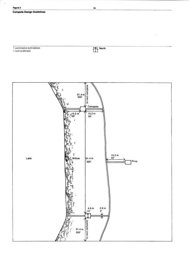
Enlarge these campsite design guidelines for Polar Bear Provincial Park (PDF)
Figure 4: Site description - Brant River area
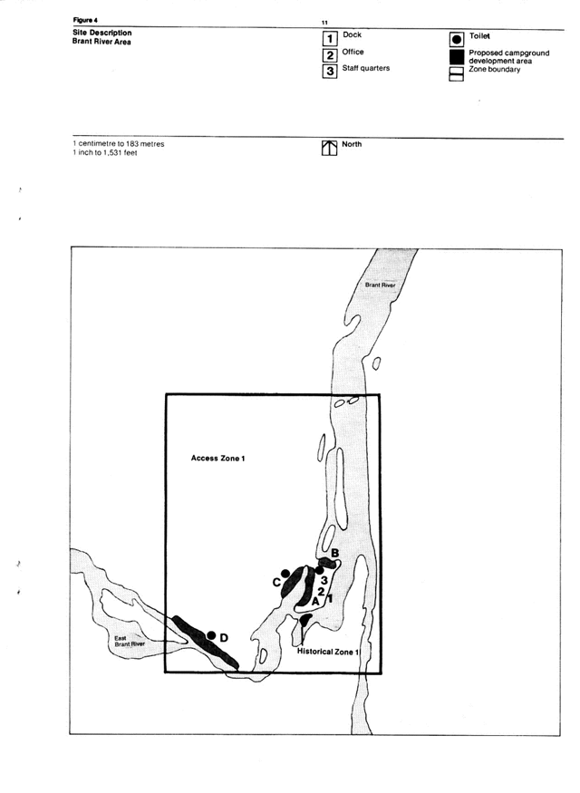
Enlarge this site description map for the Brant River area of Polar Bear Provincial Park (PDF)
7.4 Other access zones
Access by aircraft and other acceptable means to the goose camp area locations near the mouths of the Shagamu River and Sutton River will be permitted. No facilities will be available other than those provided by the camp operators. Guide-operated motor canoes will be permitted in the Sutton River and Winisk River access zones.
Site description
The site description for the Shagamu River, Sutton River and Winisk River access zones is basically the same as for the Brant River Access Zone. The locations of the zones are indicated in Figure 5. As with the Brant River, low water conditions during late July and August and occasionally September can create aircraft access problems. When water conditions are unsafe, these access zones will be officially closed to the public.
Visitor activities
Visitors to these access zones will be able to take part in:
- camping,
- canoeing,
- hunting, and
- nature study and photography.
Winisk
Although outside Polar Bear Provincial Park, the airstrip, Cree goose camp and park operations office complex at Winisk (Figure 6) will serve as an important access area. Also, guide operated motor canoes will be allowed in the Winisk River Access Zone.
Any new projects or development at Winisk aimed at servicing or supplying the park and its visitors must be consistent with the park’s goal and classification.
Potential access zones
At some point in the future, it may be advisable to create new access zones inside or at the periphery of Polar Bear Provincial Park. Master plans should be flexible enough to allow for changes over the years. However, it is also important that the wilderness concept not be jeopardized by an overabundance of interior access zones.
Presently only one additional access point is under consideration: Site 421. Because of potential aircraft land1ng hazards associated with some of the other access points, Site 421 (the only airstrip in Polar Bear with the exception of the runway at Site 415) may be required to ensure that visitors will have reasonable access alternatives to choose from in this very large park. Site 421’s status as an access zone to the Brant River will be resolved before the first five year review of the master plan. Any development of the site would be done along the lines of the proposal for Site 415 except on a much smaller scale. Such development would be kept well away from the old Mid-Canada line structures which would continue to be designated as a nature reserve zone.
Figure 5: Shagamu, Sutton and Winisk Rivers access zone locations
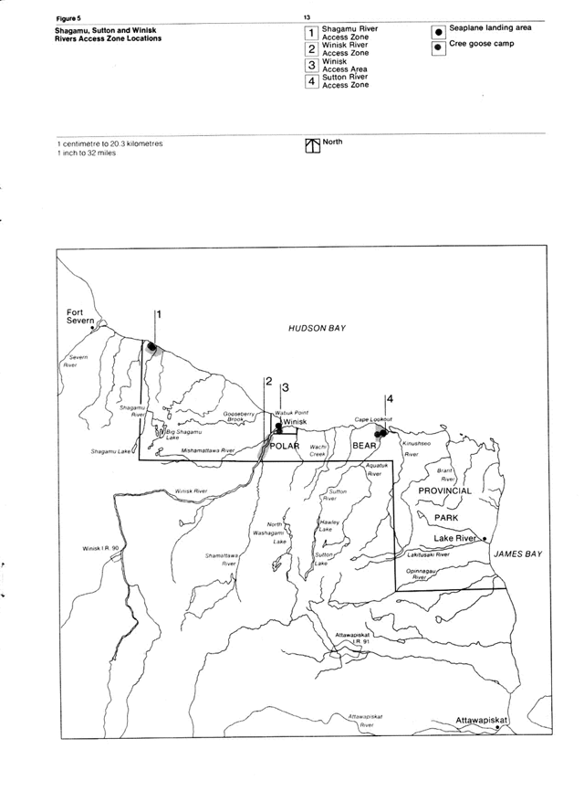
Figure 6: Winisk access area
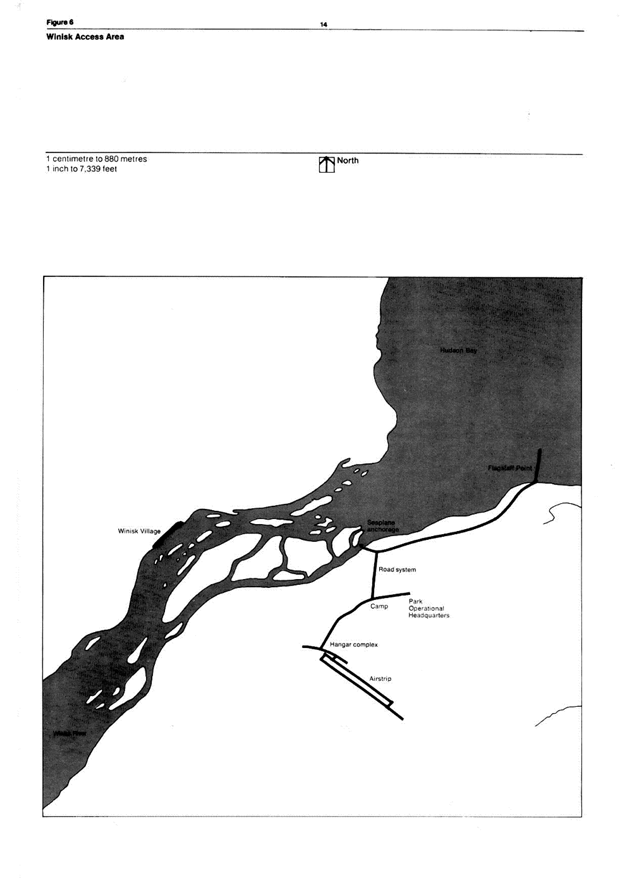
Enlarge this map of the Winisk Access area for Polar Bear Provincial Park (PDF)
8.0 Visitor services
Visitor services facilities within the park will be available at manned access zones in accordance with the management objective which states that visitor services in Polar Bear Provincial Park should consist of a program which will provide visitors with knowledge of the park’s environment, management policies, and facilities. As previously noted, this program will also be implemented outside the park at Winisk and Moosonee District Office.
In wilderness parks the potential for interpretive overkill is very real. Many legitimate themes exist and there will always be a temptation to explore them thoroughly - perhaps overly so - and lavishly in terms of media. Because of Polar Bear Provincial Park’s nature and classification such an approach would probably be mistaken.
Many of the park’s visitors will be experts at their chosen avocations, be they hiking, canoeing, angling, or other activities. They will want only some very specific directions and information. As interpretation for such users will be largely of a do-it-yourself variety, interpretive development should be carried out with appropriate restraint.
8.1 Activities
Certain outdoor activities are not in keeping with the wilderness classification and the goat of providing a tow intensity wilderness recreation experience and are therefore not acceptable or desirable in Polar Bear Provincial Park. Other activities which are appropriate (such as sunbathing and swimming) are unlikely to be attempted by many visitors because of the generally cold climate and the high incidence of biting flies. Also because of the extreme climate, winter activities such as cross-country skiing, Ice fishing. snowshoeing, and winter camping will never be very popular at Polar Bear. Groups may wish to use the Cree goose camps (al the Shagamu and Sutton access zones and at Winisk) other than during the hunting season under the operator’s guidance. Visitor services will play an important part in making visitors aware of the recreational possibilities available and also the hazards involved.
8.2 Activity direction
Angling
Some of the best brook trout fishing in Ontario is available in Polar Bear Provincial Park. Information will be available on the Game and Fish Act and its regulations, species, recommended rivers, best seasons to fish suggested lures, fishing sanctuaries, etc.
Camping
Prospective visitors will be made aware of the special equipment, techniques and precautions which will be important in ensuring a satisfying, low environmental impact camping experience in the park. Survival camping, which can be environmentally destructive will not be permitted.
Canoeing
In this wilderness park many of its visitors will be independent enough to wish to explore areas off the beaten track Rivers suitable for canoeing will purposely be left undocumented with the exception of the Winisk which is a waterway provincial park, south of Polar Bear. General safety, feasibility, and limited interpretive information about some potential park canoe routes will be made available to visitors.
Hiking
As indicated in Figure 7, there are some excellent hiking opportunities in Polar Bear Provincial Park. These include:
- The old Mid-Canada Line road from Site 415 to the James Bay coast (28.8 km; 18 miles).and
- An interconnecting series of potential trails which lie to the north of the road mentioned in (I) along a beach ridge complex.
These prospective traits provide good chances to view wildlife, and they are accessible e from the Site 415 Access Zone. The routes will be inventoried and marked where required by safety considerations, as clearly but unobtrusively as possible. Trail descriptions will be made available. Visitors to the trails will be advised to use particular caution, especially on sites off the ridges because of their considerable geological importance.
Historical appreciation
This will be largely an interpretive and information function. Details about sites of historical interests, for example, the Lake River post and the Mid-Canada Line sites - especially Site 415 - will be well-documented and made available to visitors. A description of how the sites may be reached will be included.
Hunting
The Cree goose camps at the Shagamu and Sutton rivers offer hunters some of the finest waterfowl hunting in North America. Prospective hunters will be informed of the park’s “wilderness ethic”, its regulations and its hunting lore
Nature study and photography
In addition to specific information about certain park resources visitors will have access to advice regarding what there is to see and photograph, where certain features may be located and how to reach these places.
Groups
Groups will likely wish to visit Polar Bear Provincial Park occasionally. The Ministry may be prepared to guide such groups on canoeing and hiking excursions to various designated locations.
Day-use groups of considerable size, landing at Site 415 Access Zone aboard larger aircraft could present special problems. Such groups would likely be on charter or special flights en route to Winisk from Moosonee. Presumably, they would spend up to two hours exploring the tundra on the ground the carrying capacity of the Site could easily be exceeded unless such groups were closely controlled. In addition this sort of access zone use could detract from the semi-wilderness experience of campers at the Site 415 Access Zone if the two groups are not kept well separated.
Fortunately the access zone lends itself to such a separation. Day-use groups will be routed from the airstrip south to Site 415 and thence along a short road which ends al the large lake to the west of Site 415. In a short time such a group could see good examples of both wet and dry tundra and visit a lake which invariably supports abundant birdlife. At the same time, the naturalist or group leader will be requested to ensure that visitors stay on the road, thereby presenting no threat to the environment, and that the group keeps an acceptable distance from campers.
The feasibility and desirability of such a program may be determined by Ministry-arranged charter flights A limited number of day use visitors could be brought to the site in conjunction with extended-use people on their way in or out of the park. Day-use passengers on such flights might continue on to Winisk to overnight at the Cree-operated goose camp. Opportunities for guided trout fishing excursions and exploration of the river and estuary would add considerably to such a trip.
Viewing
The landscape of Polar Bear is colourful and interesting from the air. A generalized publication depicting the park from the air will be produced and made available to visitors via the charter and commercial air services.
Interpretive themes
Because of Polar Bear’s large size and its location most of the broad themes of interpretive Unit 1, the Hudson Bay Lowland (Van dar Meer, 1973) will be identical to those of the park.
The park’s major theme centres on Polar Bear’s almost alien landscape, its vast and wild northern wilderness. These qualities, above all, seem to capture the essence or the park. They will pervade the secondary themes and be apparent in the interpretive treatment of the minor subject areas. The theme relates to other provincial parks on the Ontario Provincial Parks System particularly to wilderness parks like Killarney and Ouetico, but only Polar Bear is “vast” and “exotic”.
The secondary themes are (1) the park’s arctic element and (2) the Forest Cree in the park, past and present. There are many minor themes or subject areas which fall under these broader thematic headings and many have already been mentioned. The following outline matches minor subject areas with information and interpretive target areas.
8.3 Visitor characteristics and visitor theme relationships
The following five categories or park users are expected to visit Polar Bear Provincial Park:
- A day-use visitor who may arrive at Site 415 aboard a touring aircraft en route to Winisk;
- A scientist who may use any of the access zones;
- A sportsman who is primarily interested in hunting and/or fishing and who will therefore go the Brant River, Shagamu River, or Sutton River access zones;
- A wilderness canoeist who will enter the park from the south via the Sutton River, Winisk Rivet, or possibly other rivers;
- A wilderness-naturalist enthusiast who may enter the park at any of the access zones, but most probably at Site 415.
In terms of numbers, the persons who never actually visit the park are also important. These people develop a vicarious appreciation or the park without entering it, and they should be seriously considered in the overall visitor services program especially at Moosonee, Cochrane, and Toronto.
A generalized visitor profile indicates that the typical Polar Bear user will be a fairly affluent adult - the cost of travelling to and from the park alone implies this. Visitors would come mainly from the large urban centres of central and eastern North America, West Germany, and possibly Japan. The length of stay will probably be one week or more because of the expense of reaching the park, except for the excursion visitor on a package tour from Moosonee to Winisk and return who will likely stay for no more than a few hours. The average visitor is apt not to be a repeat customer, assuming that affluent wilderness adventurers prefer variety and have the means to obtain it. The visitor presumably will be highly motivated because of the cost and the challenges of a wilderness holiday.
The outline in Figure 8 suggests the subject areas which will be of greatest significance to the visitors expected at each target point. The interpretive services program will reflect the interests of all users.
Figure 7: Potential trail network north of the site 415 James Bay Mid-Canada Line Road
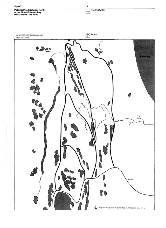
Figure 8: Visitor services target areas
[Reproduced as a table in HTML for accessibility]
| Subjects | Moosonee | Winisk | Brant River Access Zone | Shagamu River Access Zone | Site 415 Access Zone | Sutton River Access Zone |
|---|---|---|---|---|---|---|
| Park story | • | • | • | • | • | • |
| Park classification and regulations | • | • | • | • | • | • |
| Park management | • | • | • | • | • | • |
| Cree people | • | • | • | • | • | • |
| Park access | • | • | • | • | • | • |
| Outdoor recreation | • | • | • | • | • | • |
| Canoeing | • | • | • | • | • | |
| Hiking | • | • | • | • | • | • |
| Fishing | • | • | • | • | • | • |
| Hunting | • | • | • | |||
| Emergency Survival | • | • | • | • | • | |
| Trapping | • | • | • | • | • | |
| Scientific Research | • | • | • | • | • | |
| Carrying Capacity | • | • | • | • | • | • |
| Park Geology | • | • | • | • | • | • |
| Glacial history | • | • | • | • | • | • |
| Park Topography | • | • | • | • | • | • |
| Park from the air | • | • | • | • | • | • |
| Tides | • | • | • | • | • | • |
| Park climate | • | • | • | • | • | • |
| Permafrost | • | • | • | • | • | • |
| Park flora | • | • | • | • | • | • |
| Arctic element in the flora | • | • | • | • | • | • |
| Park fauna | • | • | • | • | • | • |
| Arctic element in the fauna | • | • | • | • | • | • |
| Insects | • | • | • | • | • | • |
| Fish | • | • | • | • | • | |
| Birds | • | • | • | • | • | • |
| Sea mammals | • | • | • | • | • | • |
| Caribou | • | • | • | • | • | • |
| Polar Bear | • | • | • | • | • | • |
| Park ecology | • | • | • | • | • | • |
| Park prehistory | • | • | • | • | • | • |
| Park history | • | • | • | • | • | • |
9.0 Operations
9.1 Season
The active season for most park visitors will be the months of July and August: however, the last half of June will also be used by fishermen, while September will be popular with fishermen and hunters.
9.2 Aircraft patrol
Because if its enormous size the most practical way of travel on Polar Bear Provincial park is by aircraft. Park inspection patrols and servicing of access points will be carried out by the park superintendent from the centrally located park office at Winisk on a regular basis from mid-June to the end of September. A wheeled float and radio-equipped light airplane, such as a Dehavilland Beaver or a Cessna 180 (or its equivalent) will be suitable to contract for such operations. The aircraft pilot and engineer (if required) will be engaged from early or mid-June to early or mid-October.
The patrols will be mainly enforcement oriented during the June, September and October flights. Ideally, the park superintendent should have a good enforcement background. The aircraft will help to provide a supply and communications link-up with the access zone crews during the heavy part of the visitor season and help with other park management activities. In addition the aircraft will be prepared to assist in carrying out search and rescue operations when required.
9.3 Access control and permits
Because of the limited access zone capacity and because of the long, expensive travel required to reach the park, a visit-by reservation operation is necessary. Application must be made on writing or by phone giving the names of proposed visitors, the access zones to be used, and the intended length of stay. A central control of information which will continuously monitor use at all access points will be kept at the Moosonee District Office but landing and visitor permits, required by all visitors during the official visitor season will also be available from the park operations office at Winisk. It is important that the operation of such a system be as flexible as possible until its procedures become well-advertised and workable. It should be implemented by 1981.
The Ministry divests itself of any liability in connection with hazardous water conditions for seaplanes on the park. Visitors fly at their own risk.
At Site 415 Access Zone, the maintenance of the airstrip, when required, will be done with the assistance of the Ministry of Transportation and Communications.
9.4 Fire suppression
As a very large wilderness park, Polar Bear provides its managers with an opportunity to allow a natural fire regime to operate within its boundaries. This has always been the situation as the parkland is north of 52° 30' north latitude and therefore beyond the Ontario Ministry of Natural Resources fire districts delineated under The Forest Fires Prevention Act of Ontario.
North of 52° 30' the Ministry assists with the protection of human lives and properly, and this function will be continued in the park, notably at access zones. Fire pumps, hose and packpumps will be maintained at manned Ministry access zones and at the park office at Winisk.
Because of its poorly developed drainage, Polar Bear Provincial Park during the forest fire season almost always is a mosaic of small dry areas (beach ridges, river banks and lakeshores), within a matrix of lakes, rivers and low-lying wet areas. Because of such excellent, natural firebreaks the prospect of a major fire is almost nil, except during extremely hot, dry years which are quite rare. During such exceptional periods of fire danger, visitors will be made aware of potential risks and fire prevention methods through the park information services. Sections of Polar Bear Provincial Park may be restricted to visitor use during critical periods
9.5 Emergency plan
Because of its isolation and the possibility of polar bear/human incidents, the park is potentially a hazardous place. The travel permit system will enable park personnel to give Ontario Provincial Police search and rescue people explicit directions regarding the general whereabouts of visitors in Polar Bear Provincial Park at any time.
9.6 Staffing and maintenance
These are identified in Section 11 (Implementation).
10.0 Lost resource development values
It is difficult to compute the cost of creating Polar Bear Provincial Park in terms of lost resource development values-although these appear not to be large. The proven resource products found within the park are
- gravel (from beach ridges for road building materials);
- fresh water;
- peat;
- sphagnum;
- berries (blueberries, cloudberries, cranberries, etc.);
- wood (spruce fibre and lumber);
- fur-bearing animals (bear, beaver, fox, lynx, marten, mink, muskrat, otter and wolf); and
- game animals (brook trout, geese, grouse, caribou, moose, seals and whales).
The loss of accessible gravel sources from the beach ridges which are abundant along the coast could amount to a considerable amount in the case of potential toad building, pipeline development, etc.
Although the park contains a considerable supply of fresh water, present government policy would seem to dictate against its use through diversions and other means.
Peat, sphagnum and berries, although abundant in the park, suffer from low demand and distance-from-market problems. There are stands of marketable spruce along some of the larger rivers, such as the Mishamattawa and Winisk but their distance from any market leaves them economically unexploitable at present
There is no loss of the park’s fur-producing capability, as this resource is being harvested by native trappers. Game animals are taken by native residents, and waterfowl, grouse and snipe may be shot by non-native visitors at the Cree-operated goose camps. The economics of goose and fish camp operations are such that additional camps in the park would be untenable at present
The one fairly realistic prospect which could increase the lost resource development cost of Polar Bear would be the discovery of any significant oil and/or gas reservoirs.
To balance the foregoing, it is important to recapitulate the potential values of Polar Bear Park which include:“… opportunities for a wilderness experience of solitude, space, time, and an element of unity with nature. Furthermore, it is an area of such a size as to ensure the protection of all values indefinitely. It may have scientific/ecological, conservation/educational, recreational, historic, cultural, political, spiritual, aesthetic, and economic values” (Clark and Moroz. 1973. p.8).
11.0 Implementation
A phased implementation program has been approved for capital programs, equipment, and operations. Progress associated with each of these phases is limited by:
- the annual work period of 14 weeks;
- the availability and cost of aircraft to supply, service and patrol the park;
- the availability of tradesmen;
- weather; and
- the availability of funding.
11.1 Phase I
Capital program
Moosonee District Office
Information Centre: develop exhibits, displays and audio visual programs so as to market and promote the park by informing and educating potential park clientele.
Site 415 access zone
For locations of major improvements consult Figure 2.
- Office, Information and interpretive Building: to accommodate field crew, access point administration, and records.
- Garage and Warehouse: storage, maintenance area and emergency accommodation
- Water Pressure System: to service office, garage, and laboratory
- Electric Generation System: to service office, garage, and laboratory. (Wind-powered optional)
- Permanent Dock Facilities: for float aircraft.
- Airport Upgrading: runway patching and grading and wheeled aircraft tie-downs.
- Earth Pit Toilets: 4 sets.
- Campsites, Roadways and Walkways: 6 campsites complete with tents, flys, tent bottoms, and access trails.
Equipment
Site 415 access zone
- Sleeping Bags: 50 medium weight bags for emergency visitor accommodations.
- Farm Tractor: complete with loader, hydraulic dump trailer, blade, and three-point hydraulic hitch for transportation and maintenance.
- Six Radios: for a communications network linking park with support aircraft and district office.
- Mini-incinerator: for disposal of combustible materials.
- Fire Suppression Unit: hose, pump, extinguishers and hand tools.
- Canoe: for emergency rescue purposes.
Winisk Park headquarters
Powered Motorcraft: one 7 m vee-sterned canoe with 20 hp motor and one 5.5 m vee-sterned canoe with 5 hp motor.
Operations
Staffing
| Role | Permanent/seasonal | Location | Number | Annual Work Period |
|---|---|---|---|---|
| Superintendent | Permanent | Moosonee District office | 1 | 12 months |
| Visitor Services Programmer | Permanent | Moosonee District office | 1 | 12 months |
| Assistant Superintendent | Seasonal | Winisk Park Headquarters | 1 | 9 months |
| Visitor Services Aid | Seasonal | Site 415 Access Zone | 2 | 4 months |
| Wardens/ Maintenance Staff | Seasonal | Winisk Park Headquarters/ Site 415 Access Zone | 4 | 4 months |
| Clerk | Seasonal | Moosonee District Office | 1 | 4 months |
| Maintenance Mechanic | Seasonal | Site 415 Access Zone | 1 | 4 months |
Operational staff will assist in capital programs.
Maintenance
Major facilities and services to be maintained annually are:
- Moosonee District Office information Centre
- Winisk Park Headquarters, and
- Site 415 Access Zone.
Transportation
Annual rental of float and wheel-equipped Cessna 180 or Dehavilland beaver with pilot and engineer required for a 4 month period to patrol and service the park. Off-season requirements will be met by wheel and ski-equipped Ministry aircraft.
11.2 Phase II
Capital program
Brant River access zone
For locations of improvements consult Figure 4.
- Removable Dock and Anchorage: for float plane and watercraft tie-up.
- Earth Pit Privies: 1 portable set.
- Campsites: 6 sites complete with tents, flys, tent bottoms, and access trails.
- Staff Quarters: complete with tents, flys, tent bottom, access trails, and other necessary equipment.
Site 415 access zone
Laboratory basic facilities for staff and visiting scientists.
Winisk park headquarters
- Office: building upgraded.
- Electric Generation System: replacement.
- Resource inventories: engage at least one two-man crew annually for archaeological, historical, or environmental studies.
Equipment
Brant River access zone
Fire Suppression and Patrol Equipment: includes extinguisher, hand tools, and canoe with motor.
Winisk Park headquarters
- Truck: crew cab for transportation of visitors and park staff.
- Support Equipment: for one two-man resource inventory field crew.
Operations
Staffing
The assistant park superintendent position will be upgraded from seasonal to permanent to reflect increasing workload. One additional seasonal employee will be required to administer and maintain the Brant River Access Zone and associated visitor information services.
Maintenance
Commence maintenance of the Brant River Access Zone.
11.3 Phase III
Capital program
Site 415 access zone
- Campsites: 7 sites complete with tents, flys, tent bottoms and access trails.
- Earth Pit Privies: 1 set.
Moosonee District Office
Publications/Displays: Printing and production of interpretive brochures and display materials.
Winisk Park headquarters
- Maintenance Building: replace.
- Resource inventories: to continue as on Phase II.
Maintenance
Maintain 7 additional campsites.
11.4 Other implementation tasks
- This master plan will be formally reviewed by the public and the Ministry of Natural Resources at five year intervals from the date of plan approval.
- Establish in regulation a reservation and a visitor quota system.
- Request the governments of Canada and the Northwest Territories to adopt complementary management policies for the territory adjacent to the park seaward for 15 km.
- Finalize Ministry policy and procedures for processing applications to conduct research on Polar Bear Provincial Park.
- Continue dialogue with native people to ensure their input into and understanding of any new policy. Topics to be discussed include:
- assessment of trapping and hunting in nature reserve zones
- native employment and training, and
- Native-operated goose camps.
- Establish through Transport Canada the status of the Site 415, Brant, Shagamu and Sutton seaplane landing areas and the airstrips at sites 415 and 421.
- Monitor environmental and park user data to determine resource impact.
- Investigate the feasibility of conducting air excursions into Polar Bear Provincial Park.
Appendix: Transport Canada Directives pertaining to aircraft/animal conflicts
- “Caribou Herds-Northern Canada: …the co-operation of all is requested in eliminating any action which might lead to unnecessary losses of these valuable animals…” (Aviation circular 0/30/64)
-
“Migratory birds: … the attention of all concerned is directed toward this matter, in order that they may avoid these areas when birds are using them.
Following is a list showing the principal areas frequented by geese at different times of the year … coast of Hudson Bay and James Bay loom the Ontario-Manitoba boundary to Ontario-Quebec boundary … 1st May to 31st October.”
- “Conservation of Moose-Northern Canada: Except in emergency, therefore, flights of aircraft below 1,000 feet over moose should be avoided.” (Information circular 0/16/70)
- “James Bay Coast Quebec and Ontario: …all pilots should avoid overflying this area, within five miles of the coastal tidal marshes below 2,000 feet above ground level during the periods April 15-June 15 and September 1- October 1. All aircraft approaches to coastal settlements or goose hunting camps should be made over inland terrain insofar as is practicable.”
References
Clark.C and G. Moroz. Wilderness: Philosophical Overview. Toronto: Ministry of Natural Resources.1973.
Irving, W. N. and J. Tomenchuck. Archaeology of the Brant River, Polar Bear Park. Toronto: Ontario Ministry of Natural Resources. 1972
Pollock. J. and W. Noble. Archaeology of the Hawley Lake Area. Hudson Bay Lowlands. Toronto: Ontario Ministry of Natural Resources. 1975.
Van der Meer, J. Interpretive Units. Toronto: Ontario Ministry of Natural Resources.1973 (unpublished)
Footnotes
- footnote[“1”] Back to paragraph Environmental is used in its broadest sense to include all elements of the environment such as landforms, flora and fauna.
- footnote[“2”] Back to paragraph Cree-operated goose camps existed at these locations before the legislative creation of the park. The camps will remain to serve paying guests only as long as the present operators, their families or another local native person or band wishes to maintain the facilities. (Local refers to anyone from Attawapiskat, Fort Severn, or Winisk.)
- footnote[“3”] Back to paragraph Recent experience has confirmed potentially hazardous landing and takeoff conditions at some of the recommended access points. The Ministry of Natural Resources will recommend only Transport Canada approved landing areas; however should the Shagamu and Sutton landing sites not be approved, aircraft landing will still be permitted at the owner’s risk. Visitors should check with the Moosonee District Manager regarding the Transport Canada rating of each access point.
- footnote[“5”] Back to paragraph Drainage of most of these lakes is by percolation through the surrounding materials. Stream drainage is uncommon on the beach ridge complex. For this reason, pollutants of any sort represent a definite environmental threat.