White Lake Provincial Park Management Plan
This document provides policy direction for the protection, development and management of White Lake Provincial Park and its resources.
Approval statement
We are pleased to release this management plan for White Lake Provincial Park. It is a statement of policy for the protection, management, and development of park resources.
It also provides guidance for the preparation of plans for resource management, visitor services, and development to implement park policies and achieve park objectives.
M.A. Klugman
Regional Director
Northeastern Region
Norm R. Richards, Director
Parks and Recreational Areas Branch
1. The park
White Lake Provincial Park is situated on Highway 17, 35 kilometres west of White River, and 71 kilometres east of Marathon (Figure 1). The park encompasses 1,723 hectares including part of White Lake and Dunc Lake.
The park was opened in 1962 and regulated in 1963 (Ontario Regulation 117/63). There are 187 campsites, a large day use area, a group camping area, an outdoor theatre, and many other outdoor recreational facilities. The park has always been a popular stopover for travellers on Highway 17 and a destination for fishermen. The park is becoming more popular for weekend camping and day use by a growing local population associated with the Hemlo goldfield developments in the Marathon-White River area.
The moderately broken landscape has till covered hills, sand flats, and wetlands. The sand shoreline along White Lake is one of the most popular features of the park. A mixed Boreal Forest covers the park area.
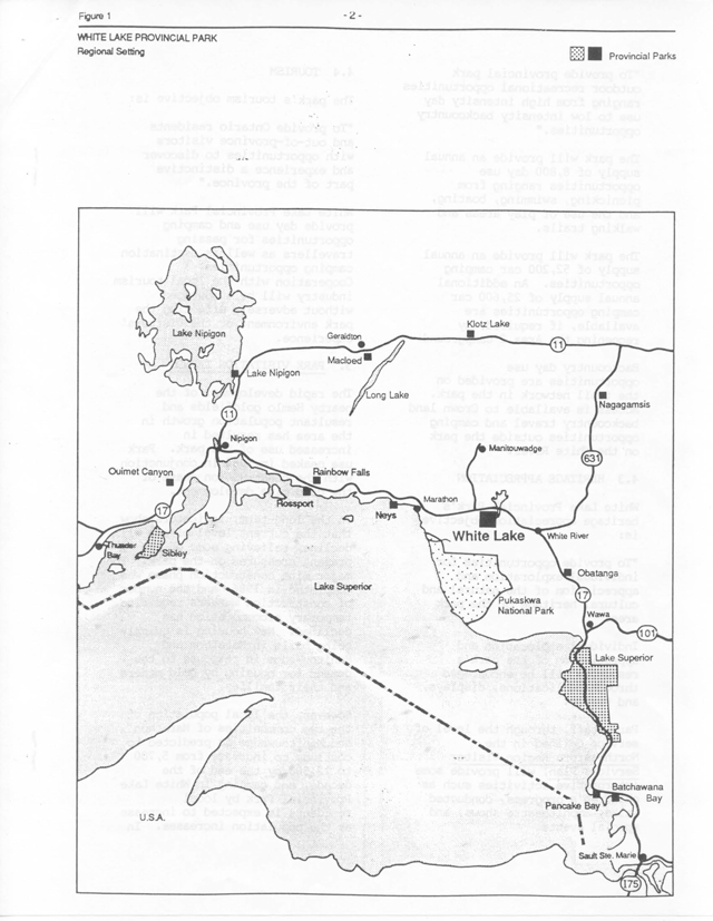
Enlarge this regional setting map of White Lake Provincial park (PDF)
2. Classification
The classification of White Lake Provincial Park will be changed from a recreation to a natural environment class. In this way, Ontario provincial park systems' target for representation of the central Boreal Forest site district will be achieved:
- glaciofluvial features typical of outwash environments in the White Lake - White River area;
- Boreal Forest vegetation patterns;
- southern outlier forest type vegetation in Red Pine stands that are uncommon in this area;
- day use and camping opportunities, a trail network and walk in access to lakes such as Clearwater afford high intensity to dispersed recreational experiences; and,
- a staging area for backcountry canoeing on the White River and beyond to Pukaskwa National Park.
3. Goal
The following goal and objectives are derived from the Ontario Provincial Parks Planning and Management Policies (OMNR, 1978). They will guide park zoning, resource management, visitor services, and development in the park.
To protect and manage the White Lake Provincial Park landscape for high quality recreational and heritage appreciation experiences.
4. Objectives
4.1 Protection
The protection objective:
To protect provincially significant natural environments incorporating natural, cultural, and recreational features.
The park landscape is representative of post-glacial activity, which resulted in extensive sand and gravel deposits such as kettled outwash plains. The park also has examples of plant species commonly found in southern areas like Red Pine and wetlands and vegetation typical of the southern Boreal region (see section 6).
4.2. Recreation
The recreation objective is:
To provide provincial park outdoor recreational opportunities ranging from high intensity day use to low intensity backcountry opportunities.
The park will provide an annual supply of 8,800 day use opportunities ranging from picnicking, swimming, boating, and the use of play areas and walking trails.
The park will provide an annual supply of 52,200 car camping opportunities. An additional annual supply of 25,600 car camping opportunities are available, if required, by reopening the Area 2 Campground.
Backcountry day use opportunities are provided on the trail network in the park. Access is available to Crown land backcountry travel and camping opportunities outside the park on the White River.
4.3 Heritage appreciation
White Lake Provincial Park’s heritage appreciation objective is:
To provide opportunities for individual exploration and appreciation of the natural and cultural heritage of the park area.
Individual exploration and appreciation of the park’s resources will be encouraged through publications, displays, and trails.
Park staff, through the level of service defined in the Northeastern Region Visitor Services Plan, will provide some 1nterpret1ve activities such as children’s programs, conducted walks, amphitheatre shows, and special events.
4.4 Tourism
The park’s tourism objective is:
To provide Ontario residents and out-of-province visitors with opportunities to discover and experience a distinctive part of the province.
White Lake Provincial Park will provide day use and camping opportunities for passing travellers as well as destination camping opportunities. Cooperation with the local tourism industry will be encouraged without adversely affecting the park environment or the visitors' experience.
5. Park visitation trends
The rapid development of the nearby Hemlo goldfields and resultant population growth in the area has resulted in increased use of the park. Park use peaked in 1984 in conjunction with the construction phase of the gold mine development.
In the long-term, indicators show that the current level of use will decline, relieving some of the present pressures on the park. The major mine construction phase was completed in 1986, and the number of construction workers requiring temporary accommodation has declined. New housing is quickly being built in Marathon and Manitouwadge in response to the demand for housing by gold miners and their families.
However, the local population of the two communities of Marathon and Manitouwadge is predicted to continue to increase from 5,700 to 12,500 by the end of the decade, and camping in White Lake Provincial Park by local residents is expected to increase as the population increases. In the short-term, park visitation will drop from the 1984 level but should still be at least 20% greater than the use in 1983.
This 20% increase will result from:
- more use of the park from the local increased population; and,
- addition of electrical service to some campsites to attract more campers with camping vehicles requiring electricity.
6. Zoning
The lands and waters within White Lake Provincial Park have been zoned so that they may be allocated to their most appropriate use. There is a development zone, natural environment zone, and two nature reserve zones (Figure 2). Development and management policies for these zones can be found in Ontario Provincial Parks Planning and Management Policies.
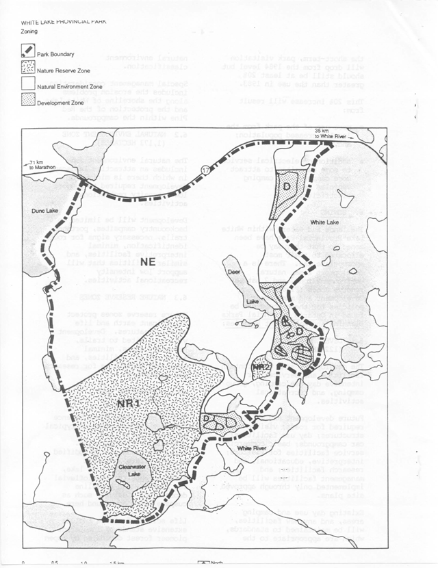
Enlarge this zoning map for White Lake Provincial Park (PDF)
6.1 Development zone ( 122 hectares)
The development zone will contain facilities and services for intensive day use camping, group camping, and recreational activities.
Future development and maintenance required for roads; visitor control structures; day use facilities; car campgrounds; basic commercial service facilities for visitors; interpretive, educational, and research facilities; and management facilities will be implemented only through approved site plans.
Existing day use and camping areas, and any new facilities, will be maintained to standards, which are appropriate to the natural environment classification.
Special management consideration includes the erosion problems along the shoreline of White Lake and the protection of the Red Pine within the campgrounds.
6.2 Natural environment zone (1,173 hectares)
The natural environment zone includes an attractive landscape in which there is minimum of development required to support low intensity recreational activities.
Development will be limited to backcountry campsites, portages, trails, necessary signs for route identification, mineral interpretive facilities, and similar facilities that will support low intensity recreational activities.
6.3 Nature reserve zones
Nature reserve zones protect significant earth and life science features. ·Development will be limited to trails, necessary signs, minimal interpretive facilities, and temporary facilities for research and management.
NR 1 Clearwater Lake (419 Hectares)
Within this zone, earth science features include examples typical of glaciofluvial and glaciolocustrine deposits. Kettled outwash plains modified by lake waters, morainic deposits, a clear water lake, aeolian deposits, glaciofluvial ice contact, and shoreline depositional features such as cuspate spits are found here.
Life science features include extensive stands of intolerant pioneer forest dominated by aspen or Jack Pine as well as wetland communities such as marshes, open and treed bogs, and coniferous swamps, which occupy drainage ways and kettle depressions. It is in these wetlands that a great many of the park’s orchid species are found. The portion of the nature reserve zone that borders on White Lake also includes shoreline marshes.
NR 2 Red Pine (9 Hectares)
This area is the only known stand of Red Pine outside of the campground. Stands of Red Pine are uncommon in the central Lake Superior area.
7. Resource management
The park will be managed in accordance with the general planning and management policies for natural environment class provincial parks.
Although the policies are presented separately, all planning and management will recognize that the components are interrelated, and an integrated approach will be taken in park operation planning.
7.1 Water
The water level of White Lake is regulated by a dam at the south end of the lake. The dam is maintained by Engineering Services of the Ontario Ministry of Natural Resources and monitored by White Lake Provincial Park staff. The water level will be kept at an optimum level agreed upon by resource users.
7.2 Fisheries
Sportfishing is one of the main attractions of visitors to the park. Fishing takes place both on the lakes within the park and on White and Dune Lakes adjacent to the park.
The lakes will be managed so that sportfishing will continue as a viable recreational activity for park visitors. Park staff will provide input to the Wawa District Fisheries Management Plan when it is undertaken. The plan will address stocking requirements and management of natural populations in lakes within and adjacent to the park.
7.3 Vegetation
Vegetation in the park’s development zone will be managed to fulfill protection and recreation objectives. Management guidelines will be derived from environmental management policies for natural environment parks.
To maintain an attractive camping experience in the development zone, a vegetation management plan will be prepared according to the following principles to:
- create suitable campsite buffering;
- rehabilitate areas lacking natural growth;
- remove hazardous trees;
- promote regeneration;
- maintain vegetation cover in the beach areas with tall trees for shade, scattered clumps of low vegetation for privacy screening, and buffer vegetation between parking and day use areas;
- sustain the Red Pine stands within the campground; and,
- evaluate the desirability for maintaining the Red Pine Nature Reserve Zone.
Park staff will contribute to the development of the fire management plan for the Northeastern Region to ensure that park objectives are met.
7.4 Wildlife
Opportunities for wildlife viewing will be encouraged.
Hunting is not permitted within White Lake Provincial Park.
Commercial trapping is not allowed. Existing trapping rights will be phased out in a manner least harmful to the existing trapper. No new trappers or traplines will be permitted.
Removal of animals that endanger the health and safety of park visitors or park facilities will be allowed.
8. Visitor services
The visitor services program will provide visitors with an opportunity to gain an understanding, awareness, and appreciation of White Lake Provincial Park, its heritage, and management. This will be achieved through the policies from the Northeastern Region Visitor Services Plan for the following components: information, interpretation, outdoor recreation, research, and marketing.
Park visitor services planning will guide the best combination of these components in keeping with self-use and recreational emphasis. Cooperation will continue with Pukaskwa National Park as well as with other provincial parks along Highway 17.
8.1 Information
Information concerning park resource management, facilities, programs, and nearby points of interest will be available at key points throughout the park (park gate house, comfort station, etc.).
Information will be made available in the form of a park leaflet, information displays, special publications as required, and through informed park staff.
8.2 Interpretation
The park interpretive program will create a greater understanding of the natural and cultural values of the park’s themes:
- White Lake and its Environs;
- Logging the White River Watershed;
- The Canadian Pacific Railway;
- The Fur Trade;
- Native History;
- The Boreal Forest;
- Outdoor Recreation;
- Glaciation and the Canadian Shield; and,
- Hemlo - A Modern Gold Rush.
The interpretive program will consist of self-use facilities and staff-led activities. The self-use facilities will include such things as the Deer Lake Trail and Guide, the display area for the Water Tank Sleigh Historical Exhibit, and the Tiny Bog Trail. There is potential for a mining theme exhibit area at a site that would support the existing visitor services operations.
Interpretive programs may be held at the amphitheatre and the Visitor Centre. Conducted walks, campfire shows, demonstrations, campsite visitations, and other activities may be· presented on a scheduled basis.
8.3 Outdoor recreation
Outdoor recreation programming will concentrate on water ·· related activities such as canoeing skills, sportfishing, and water safety. Backcountry ethics will also be presented. Park development policies and resource management activities will be explained to the public.
8.4 Research
Research related to the needs of resource management (e.g. vegetation and fisheries) will have priority. All activity will follow the policies for research in provincial parks.
8.5 Marketing
Attracting additional people from the Highway 17 travel corridor will continue. Through upgrading of park facilities and services (see Resource Management, Development, and Visitor Services sections of this plan), together with staff training and cooperation with local outfitters and businesses, visitors will be encouraged to stay longer and also return to the park and area in the future.
Campground facility improvements will enhance use. The 1982 camper survey, for example, showed that 66% of the campers at the park used motor homes, trailers, vans, etc. Camping vehicles like these are often equipped to use electrical power. Electrical outlets at campsites will make the park more attractive to campers.
The use of the park by the residents of Marathon, Manitouwadge, and White River has been steadily increasing. The upgrading of facilities and services, ongoing staff training in customer hospitality, and local outfitting will also help increase use of the park by local residents. Marketing efforts at the beginning and end of the camping season will help increase use in these traditionally slow periods.
Park staff will continue to cooperate in marketing efforts with other provincial parks and private commercial tourist operations. This includes making sure that park information is available at tourist information centres and at other parks on Highway 17.
A potential secondary market is the backcountry traveller. White Lake Provincial Park, in cooperation with Pukaskwa National Park, is being used by people canoeing the White River as a staging area for their trips. Facilities and services for this type of park visitor can also be used to serve recreationists inside and outside the park.
The marketing plan for the park will be updated as required.
9. Development
All development within White Lake Provincial Park will reflect the standards for a natural environment class park. Development projects will be proposed through work program planning and special funding initiatives (Figure 3). All development will be carried out in accordance with approved site and development plans. Once the development takes place, it will be managed according to the operating plan for the park.
The requirements of the Environmental Assessment Act and other relevant legislat1on will be met.
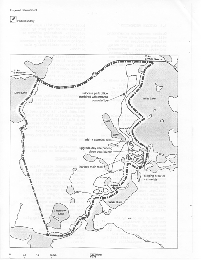
Enlarge this proposed development map for White Lake Provincial Park (PDF)
9.1 Car camping use
In response to the needs of park visitors and also to help increase camping use, additional electrical service to campsites is required Additional electrical services will be provided in Woodlily Campground.
The group camping area is becoming more popular for local groups and adult groups travelling together on Highway 17. A second group camping area is required, preferably separate from the existing group camping area.
9.2 Day use
The Area 1 day use parking lot will be upgraded to increase day use parking capacity. The boat launch near the Area 2 Campground will replace the boat launch closed in Area 1. Picnic shelter needs will be evaluated with necessary site planning work.
9.3 Backcountry use
The Area 2 Campground boat launch facility will be utilized as a staging area for backcountry users. Facilities that are needed include a storage area for boat trailers and canoeist vehicles and open space areas near the water to allow canoe trippers to get organized. The canoe registration booth for Pukaskwa National Park will also be part of this staging area.
9.4 Park office/entrance control
A park office is needed to provide adequate working space for the Park Superintendent and Park Clerk. The new site will be associated with the park entrance control so that it is convenient for both park staff and park visitors. A development plan is required.
9.5 Access and campground roads
The main road through the campgrounds and to the day use area will be hardtopped. This would alleviate dust and maintenance problems.
9.6 Hemlo concept
There is considerable potential to develop a visitor services facility in the park to tell the Hemlo story. The concept needs further definition through park visitor services planning and the approval of site and development plans.
10. Plan implementation and review
10.1 Implementation
The recommended development will be started with the formal approval of this management plan. The number of projects completed will be based on the level of funding made available through annual approval of work program plans and alternative funding proposals.
10.1.1 Priorities
Available Funding –
Work Program Planning:
- park classification change.
Resource Management Planning:
- prepare a vegetation management plan for the development zone; and,
- park staff will provide input to a Wawa District Fisheries Management Plan.
Visitor Services:
- prepare a visitor services plan.
Additional Funding Proposals –
Site and Development Planning:
- upgrade the electrical service in Woodlily Campground;
- provide a second group camping area;
- upgrade day use parking lot Area 1 to increase capacity for vehicles and picnic use;
- develop a new park office/entrance control;
- upgrade and hardtop the main road through Area 1 campgrounds and the road to Area 1 day use area; and,
- develop a mining theme exhibit
10.2 Plan review
This management plan will stand for 20 years and will be reviewed to determine its effectiveness and adequacy of policies as the need arises.
If changes to the policies herein are needed at any time, the significance of changes will be evaluated; and if necessary, the plan will be reviewed with the public prior to formal amendment.
11. Public consultation
This park management plan is a result of a continuing consultation process that has considered the needs, desires, and opinions of a variety of interests.
Public involvement in the plan began during the summer of 1986 with news releases requesting public input. Background information was available from August to early September of 1986 at the park and the Wawa District Office. Copies of the preliminary management plan were mailed directly to interest groups, other government ministries, and adjacent property owners. They were requested to submit, within 30 days, any comments regarding the management plan to the District Manager in Wawa.Copies of all comments received were available for viewing at the Wawa District Office.
In applying this park management plan, the Ontario Ministry of Natural Resources is committed to continuing this consultation with government agencies, other ministries, interest groups, and the public. It is important that the channels of communication that have been created by this consultation process be kept open.
Select references
Noble, T., Central Boreal Forest Region 3E Life Science Report, Northeastern Region, 1973.
Ontario Ministry of Natural Resources, Wawa District Land Use Guidelines, 1983.
White Lake Provincial Park Marketing Plan, 1982.
Provincial Park Camper Survey Summary Statistical Report, 1982.
Provincial Park Day Use Survey Summary Statistical Report, 1982.
Archaeological Survey – North Central Region, 1974.
Northeastern Region Visitor Services Plan, 1988.