White Wood Aster recovery strategy
Read the recovery strategy for the White Wood Aster, a plant species at risk in Ontario.
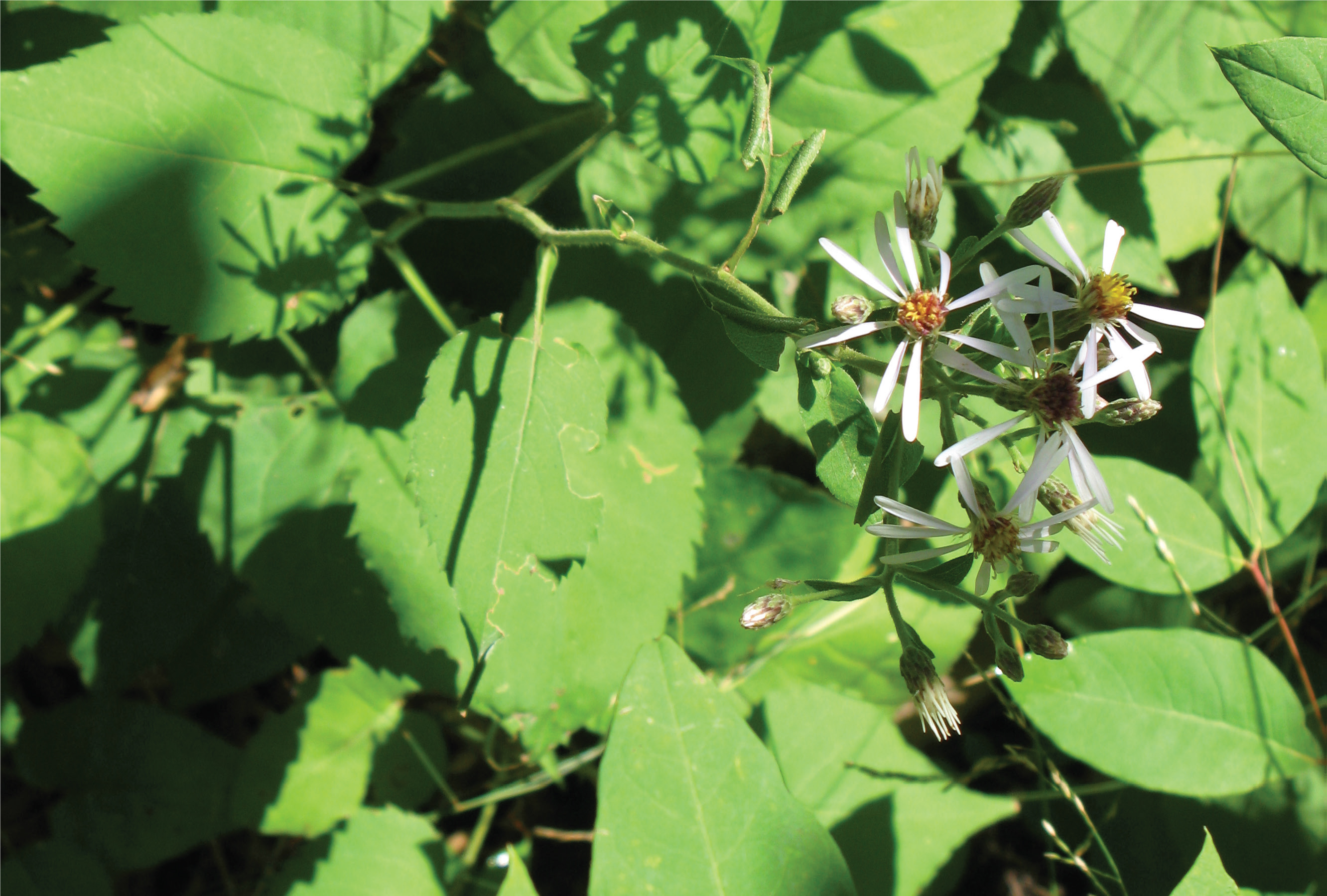
Photo by Rob Tervo
About the Ontario recovery strategy series
This series presents the collection of recovery strategies that are prepared or adopted as advice to the Province of Ontario on the recommended approach to recover species at risk. The Province ensures the preparation of recovery strategies to meet its commitments to recover species at risk under the Endangered Species Act, 2007 (ESA) and the Accord for the Protection of Species at Risk in Canada.
What is recovery?
Recovery of species at risk is the process by which the decline of an endangered, threatened, or extirpated species is arrested or reversed, and threats are removed or reduced to improve the likelihood of a species’ persistence in the wild.
What is a recovery strategy?
Under the ESA a recovery strategy provides the best available scientific knowledge on what is required to achieve recovery of a species. A recovery strategy outlines the habitat needs and the threats to the survival and recovery of the species. It also makes recommendations on the objectives for protection and recovery, the approaches to achieve those objectives, and the area that should be considered in the development of a habitat regulation. Sections 11 to 15 of the ESA outline the required content and timelines for developing recovery strategies published in this series.
Recovery strategies are required to be prepared for endangered and threatened species within one or two years respectively of the species being added to the Species at Risk in Ontario list. Recovery strategies are required to be prepared for extirpated species only if reintroduction is considered feasible.
What’s next?
Nine months after the completion of a recovery strategy a government response statement will be published which summarizes the actions that the Government of Ontario intends to take in response to the strategy. The implementation of recovery strategies depends on the continued cooperation and actions of government agencies, individuals, communities, land users, and conservationists.
For more information
To learn more about species at risk recovery in Ontario, please visit the Ministry of the Environment, Conservation and Parks Species at Risk webpage.
Recommended citation
Ministry of the Environment, Conservation and Parks. 2019. Recovery Strategy for the White Wood Aster (Eurybia divaricata) in Ontario. Ontario Recovery Strategy Series. Prepared by the Ministry of the Environment, Conservation and Parks, Peterborough, Ontario. iv + 7 pp. + Appendix. Adoption of the Recovery Strategy for White Wood Aster (Eurybia divaricata) in Canada (Environment and Climate Change Canada 2018).
© Queen’s Printer for Ontario, 2019
ISBN 978-1-4868-3916-2 (HTML)
ISBN 978-1-4868-3917-9 (PDF)
Content (excluding illustrations) may be used without permission with appropriate credit to the source, except where use of an image or other item is prohibited in the content use statement of the adopted federal recovery strategy.
Cette publication hautement spécialisée « Recovery strategies prepared under the Endangered Species Act, 2007 », n’est disponible qu’en anglais en vertu du Règlement 671/92 qui en exempte l’application de la Loi sur les services en français. Pour obtenir de l’aide en français, veuillez communiquer avec recovery.planning@ontario.ca.
Acknowledgments
The Ministry gratefully acknowledges Paul O’Hara (field botanist and native plant cultivation specialist, Blue Oak Native Landscapes) for information and insights regarding the recovery of White Wood Aster in Ontario.
Declaration
The recovery strategy for the White Wood Aster (Eurybia divaricata) was developed in accordance with the requirements of the Endangered Species Act, 2007 (ESA). This recovery strategy has been prepared as advice to the Government of Ontario, other responsible jurisdictions and the many different constituencies that may be involved in recovering the species.
The recovery strategy does not necessarily represent the views of all individuals who provided advice or contributed to its preparation, or the official positions of the organizations with which the individuals are associated.
The recommended goals, objectives and recovery approaches identified in the strategy are based on the best available knowledge and are subject to revision as new information becomes available. Implementation of this strategy is subject to appropriations, priorities and budgetary constraints of the participating jurisdictions and organizations.
Success in the recovery of this species depends on the commitment and cooperation of many different constituencies that will be involved in implementing the advice set out in this strategy.
Responsible jurisdictions
Ministry of the Environment, Conservation and Parks
Environment and Climate Change Canada – Canadian Wildlife Service, Ontario
Parks Canada Agency
Executive summary
The Endangered Species Act, 2007 (ESA) requires the Minister of the Environment, Conservation and Parks to ensure recovery strategies are prepared for all species listed as endangered or threatened on the Species at Risk in Ontario (SARO) List. Under the ESA, a recovery strategy may incorporate all or part of an existing plan that relates to the species.
The White Wood Aster (Eurybia divaricata) is listed as threatened on the SARO List. The species is listed as threatened under the federal Species at Risk Act (SARA). Environment and Climate Change Canada prepared the Recovery Strategy for the White Wood Aster (Eurybia divaricata) in Canada in 2018 to meet its requirements under the SARA. This recovery strategy is hereby adopted under the ESA. With the additions indicated below, the enclosed strategy meets all of the content requirements outlined in the ESA.
Additional information is included on the distribution and abundance of White Wood Aster and survey activities that were completed during the 2018 field season.
The Critical Habitat section of the federal recovery strategy provides an identification of critical habitat (as defined under the SARA). Identification of critical habitat is not a component of a recovery strategy prepared under the ESA. However, it is recommended that the approach used to identify critical habitat in the federal recovery strategy, along with any new scientific information pertaining to the White Wood Aster and the areas it occupies, be considered when developing a habitat regulation under the ESA.
1.0 Adoption of federal recovery strategy
The Endangered Species Act, 2007 (ESA) requires the Minister of the Environment, Conservation and Parks to ensure recovery strategies are prepared for all species listed as endangered or threatened on the Species at Risk in Ontario (SARO) List. Under the ESA, a recovery strategy may incorporate all or part of an existing plan that relates to the species.
The White Wood Aster (Eurybia divaricata) is listed as threatened on the SARO List. The species is listed as threatened under the federal Species at Risk Act (SARA). Environment and Climate Change Canada prepared the Recovery Strategy for the White Wood Aster (Eurybia divaricata) in Canada in 2018 to meet its requirements under the SARA. This recovery strategy is hereby adopted under the ESA. With the additions indicated below, the enclosed strategy meets all of the content requirements outlined in the ESA.
1.1 Species assessment and classification
The following list is assessment and classification information for the White Wood Aster (Eurybia divaricata). Note: The glossary provides definitions for the abbreviations and technical terms in this document.
- SARO List Classification: Threatened
- SARO List History: Threatened (2008, 2002, 2000)
- COSEWIC Assessment History: Threatened (2002, 1995)
- SARA Schedule 1: Threatened (2005)
- Conservation Status Rankings: G-rank: G5; N-rank: N2N3; S-rank: S2S3
1.2 Distribution, abundance and population trends
During field investigations in the summer and autumn of 2018, nine populations or subpopulations of White Wood Aster were reconfirmed, and five new locations of populations or subpopulations were identified
Table 1. New and updated information on local populations and subpopulations of White Wood Aster in Ontario.
| Local population / subpopulation location name | Local population / subpopulation status | Year last observed | Stem count when last observed |
|---|---|---|---|
| Culp’s Woods | Extant; previously reported | 2018 | >3500 |
| Two Mile – Four Mile Creek ANSI / Four Mile Creek | Extant; previously reported | 2018 | 50 |
| Two Mile – Four Mile Creek ANSI / Two Mile Creek | Extant; previously reported | 2018 | 110 |
| Paradise Grove | Extant; previously reported | 2018 | >250 |
| Lancaster Park | Extant; previously reported | 2018 | >1300 |
| Woodlawn Park | Extant; previously reported | 2018 | 8000-9000 |
| Woodland Elementary School Grove | Extant; previously reported | 2018 | >650 |
| Fonthill-Sandhill Valley ANSI | Extant; previously reported | 2018 | 1000s |
| Hillcrest Park, Pelham | Extant; previously reported | 2018 | >750 |
| Newark Park, Niagara-on-the-Lake | Extant; newly reported | 2018 | >6000 |
| Garner Trail Woods, west of St. Michael’s Avenue, Niagara Falls | Extant; newly reported | 2018 | 230 |
| Aqueduct Park, Welland | Extant; newly reported | 2018 | 15 |
| Ricelawn Park, Welland | Extant; newly reported | 2018 | 1000 |
| Lathrop Woods Nature Preserve, Fonthill | Extant; newly reported | 2018 | 30 |
White Wood Aster was not detected in 2018 at four sites where it was last detected in 2008. These are (1) Dufferin Island, (2) Beamsville Escarpment Life Science ANSI, (3) Along Bruce Trail North of Queenston Quarry and (4) North Pelham Valley ANSI (O’Hara 2018).
1.3 Recovery actions completed or underway
Surveys have been completed within the northern half of the Regional Municipality of Niagara to re-confirm the presence of White Wood Aster at several locations and determine whether or not it is present at other locations with suitable site conditions. These surveys occurred during the summer and fall of 2018.
1.4 Area for consideration in developing a habitat regulation
Under the ESA, a recovery strategy must include a recommendation to the Minister of the Environment, Conservation and Parks on the area that should be considered in developing a habitat regulation. A habitat regulation is a legal instrument that prescribes an area that will be protected as the habitat of the species. The recommendation provided below will be one of many sources considered by the Minister, including information that may become newly available following completion of the recovery strategy, when developing the habitat regulation for this species.
The Critical Habitat section of the federal recovery strategy provides an identification of critical habitat (as defined under the SARA). Identification of critical habitat is not a component of a recovery strategy prepared under the ESA. However, it is recommended that the approach used to identify critical habitat in the federal recovery strategy, along with any new scientific information on White Wood Aster and the areas it occupies, be considered when developing a habitat regulation under the ESA.
Glossary
- Committee on the Status of Endangered Wildlife in Canada (COSEWIC)
- The committee established under section 14 of the Species at Risk Act that is responsible for assessing and classifying species at risk in Canada.
- Committee on the Status of Species at Risk in Ontario (COSSARO)
- The committee established under section 3 of the Endangered Species Act, 2007 that is responsible for assessing and classifying species at risk in Ontario.
- Conservation status rank
- A rank assigned to a species or ecological community that primarily conveys the degree of rarity of the species or community at the global (G), national (N) or subnational (S) level. These ranks, termed G-rank, N-rank and S-rank, are not legal designations. Ranks are determined by NatureServe and, in the case of Ontario’s S-rank, by Ontario’s Natural Heritage Information Centre. The conservation status of a species or ecosystem is designated by a number from 1 to 5, preceded by the letter G, N or S reflecting the appropriate geographic scale of the assessment. The numbers mean the following:
1 = critically imperilled
2 = imperilled
3 = vulnerable
4 = apparently secure
5 = secure
NR = not yet ranked - Endangered Species Act, 2007 (ESA)
- The provincial legislation that provides protection to species at risk in Ontario.
- Species at Risk Act (SARA)
- The federal legislation that provides protection to species at risk in Canada. This Act establishes Schedule 1 as the legal list of wildlife species at risk. Schedules 2 and 3 contain lists of species that at the time the Act came into force needed to be reassessed. After species on Schedule 2 and 3 are reassessed and found to be at risk, they undergo the SARA listing process to be included in Schedule 1.
- Species at Risk in Ontario (SARO) List
- The regulation made under section 7 of the Endangered Species Act, 2007 that provides the official status classification of species at risk in Ontario. This list was first published in 2004 as a policy and became a regulation in 2008.
List of abbreviations
- ANSI
- Area of Natural and Scientific Interest
- COSEWIC
- Committee on the Status of Endangered Wildlife in Canada
- COSSARO
- Committee on the Status of Species at Risk in Ontario
- ESA
- Ontario’s Endangered Species Act, 2007
- ISBN
- International Standard Book Number
- MECP
- Ministry of the Environment, Conservation and Parks
- MNRF
- Ministry of Natural Resources and Forestry
- SARA
- Canada’s Species at Risk Act
- SARO List
- Species at Risk in Ontario List
References
O’Hara, P. 2018. 2018 White Wood Aster (Eurybia divaricata) Survey. Interim Report completed for Ontario Species at Risk Stewardship Fund. Blue Oak Native Landscapes, Hamilton.
Personal communications
O’Hara, P. 2019. Email correspondence to E. Snyder. January 2019. Field Botanist and Native Plant Cultivation Specialist, Blue Oak Native Landscapes. Hamilton, Ontario.
Appendix 1. Recovery strategy for the White Wood Aster (Eurybia divaricata) in Canada
Official title: Recovery Strategy for the White Wood Aster (Eurybia divaricata) in Canada 2018
Species at Risk Act (SARA)
Recovery strategy series

Document information
Environment and Climate Change Canada. 2018. Recovery Strategy for the White Wood Aster (Eurybia divaricata) in Canada, Species at Risk Act Recovery Strategy Series. Environment and Climate Change Canada, Ottawa, viii + 67 pp.
For copies of the recovery strategy, or for additional information on species at risk, including the Committee on the Status of Endangered Wildlife in Canada (COSEWIC) Status Reports, residence descriptions, action plans, and other related recovery documents, please visit the Species at Risk (SAR) Public Registry.
Cover IIlustration: Vanessa Dufresne, Environment and Climate Change Canada, Canadian Wildlife Service – Quebec Region
Également disponible en français sous le titre « Programme de rétablissement de l’aster à rameaux étalés (Eurybia divaricata) au Canada »
© Her Majesty the Queen in Right of Canada, represented by the Minister of Environment and Climate Change, 2018. All rights reserved.
ISBN 978-0-660-28930-4
Catalogue no. En3-4/307-2018E-PDF
Content (excluding the illustrations) may be used without permission, with appropriate credit to the source.
Preface
The federal, provincial, and territorial government signatories under the Accord for the Protection of Species at Risk (1996) agreed to establish complementary legislation and programs that provide for effective protection of species at risk throughout Canada. Under the Species at Risk Act (S.C. 2002, c.29) (SARA), the federal competent ministers are responsible for the preparation of recovery strategies for listed Extirpated, Endangered, and Threatened species and are required to report on progress within five years after the publication of the final document on the SAR Public Registry.
The Minister of Environment and Climate Change is the competent minister under SARA for the White Wood Aster and has prepared this recovery strategy, as per section 37 of SARA. To the extent possible, it has been prepared in cooperation with the governments of Ontario and Quebec, as per section 39(1) of SARA.
Success in the recovery of this species depends on the commitment and cooperation of many different constituencies that will be involved in implementing the directions set out in this strategy and will not be achieved by Environment and Climate Change Canada or any other jurisdiction alone. All Canadians are invited to join in supporting and implementing this strategy for the benefit of the White Wood Aster and Canadian society as a whole.
This recovery strategy will be followed by one or more action plans that will provide information on recovery measures to be taken by Environment and Climate Change Canada and other jurisdictions and/or organizations involved in the conservation of the species. Implementation of this strategy is subject to appropriations, priorities, and budgetary constraints of the participating jurisdictions and organizations.
The recovery strategy sets the strategic direction to arrest or reverse the decline of the species, including identification of critical habitat to the extent possible. It provides all Canadians with information to help take action on species conservation. When critical habitat is identified, either in a recovery strategy or an action plan, SARA requires that critical habitat then be protected.
In the case of critical habitat identified for terrestrial species including migratory birds SARA requires that critical habitat identified in a federally protected area
For critical habitat located on other federal lands, the competent minister must either make a statement on existing legal protection or make an order so that the prohibition against destruction of critical habitat applies.
If the critical habitat for a migratory bird is not within a federal protected area and is not on federal land, within the exclusive economic zone or on the continental shelf of Canada, the prohibition against destruction can only apply to those portions of the critical habitat that are habitat to which the Migratory Birds Convention Act, 1994 applies as per SARA ss. 58(5.1) and ss. 58(5.2).
For any part of critical habitat located on non-federal lands, if the competent minister forms the opinion that any portion of critical habitat is not protected by provisions in or measures under SARA or other Acts of Parliament, or the laws of the province or territory, SARA requires that the Minister recommend that the Governor in Council make an order to prohibit destruction of critical habitat. The discretion to protect critical habitat on non-federal lands that is not otherwise protected rests with the Governor in Council.
Acknowledgments
Development of this recovery strategy was facilitated by Allison Foran and Marie-Claude Archambault (Environment and Climate Change Canada, Canadian Wildlife Service (CWS) – Ontario); and Vanessa Dufresne, Emmanuelle Fay, Martine Benoit, Marie-José Ribeyron and Patricia Désilets (CWS – Quebec). Additional preparation and review was provided by Krista Holmes, Angela Darwin, Judith Girard, Burke Korol, Christina Rohe, Elisabeth Shapiro (CWS – Ontario), Gary Allen (Parks Canada Agency), Leanne Marcoux, Megan McAndrew, Michael J. Oldham, Jim Saunders, Eric Snyder, Mark Hulsman, Lucy Ellis, Jay Fitzsimmons, and Glenn Desy (Ontario Ministry of Natural Resources and Forestry). The following people are gratefully acknowledged for providing support in the development of this document: Jacques Labrecque, Nancy Hébert and Line Couillard (Ministère du Développement durable, de l’Environnement et de la Lutte contre les changements climatiques); Maryse Boisvert, Albert Garofalo and Paul Robertson.
Executive summary
In Canada, the White Wood Aster (Eurybia divaricata) occurs in southern Ontario and in southwestern Quebec. The species is listed as Threatened under Schedule 1 of the Species at Risk Act (SARA). The species is ranked as Imperilled to Vulnerable in Canada (N2N3) and Ontario (S2S3) and Imperilled in Quebec (S2). The global range of the White Wood Aster is restricted to eastern North America, and it reaches its southern limit in the U.S. states of Georgia and Alabama. The species’ northern limit is in Canada where there are a total of 56 known extant
The White Wood Aster is an herbaceous late summer-to-fall-flowering perennial. The flower heads consist of petal-like white rays surrounding small yellow and purple disc florets. The upper leaves are deeply serrated, and the lower ones are heart-shaped. The species occurs in open deciduous and mixed forests. Owing to its preference for open sun-exposed areas, the species is sometimes found in disturbed areas, including woodlots disturbed by small-scale forest harvesting and the edges of recreational trails.
The primary threat to the White Wood Aster is habitat loss due to urban and agricultural development. Other threats include forest harvesting, alteration of the natural disturbance regime, invasive species, grazing by deer, and off-trail recreational activities.
The recovery of the White Wood Aster is considered feasible; therefore, this recovery strategy has been prepared as per section 41(1) of SARA. The population and distribution objectives for the White Wood Aster are: maintain the current distribution and abundance (i.e., total number of stems) of the White Wood Aster in Canada; and where necessary and technically and biologically feasible, support natural increases of abundance (i.e., total number of stems) of extant local populations. The broad strategies to be taken to address the threats to the survival and recovery of the species are presented in the section on Strategic Direction for Recovery (Section 6.2). They include surveys and monitoring, research, habitat management and conservation, landuse policy and planning, and communication, outreach and education.
Critical habitat for the White Wood Aster is partially identified in this recovery strategy, based on the best available data. Where detailed surveys have been conducted and White Wood Aster plant locations are known, critical habitat is identified as the extent of biophysical attributes (7.1.1) up to 80 m (radial distance) around existing mapped observations of the White Wood Aster. In cases where little or no mapping and/or documentation of plant locations or habitat features exists, but the approximate location of the local population has been verified, the area containing critical habitat is identified as the ecological or landscape feature containing the local population (7.1.2), and critical habitat for White Wood Aster is identified as the extent of biophysical attributes (7.1.1) up to 80 m (radial distance) from any single plant wherever they occur within the areas containing critical habitat (7.1.2). In addition, in cases where the suitable habitat extends for less than 50 m around a White Wood Aster, a critical function zone capturing an area within a radial distance of 50 m is also included as critical habitat. A schedule of studies is included to obtain the information needed to complete the identification of critical habitat. As more information becomes available, additional critical habitat may be identified where critical habitat criteria are met. One or more actions plans for the White Wood Aster will be posted on the Species at Risk Public Registry by December 31, 2024.
Recovery feasibility summary
Based on the following four criteria that Environment and Climate Change Canada uses to establish recovery feasibility, recovery of the White Wood Aster has been deemed technically and biologically feasible.
1. Individuals of the wildlife species that are capable of reproduction are available now or in the foreseeable future to sustain the population or improve its abundance.
Yes. The presence of viable local populations
2. Sufficient suitable habitat is available to support the species or could be made available through habitat management or restoration.
Yes. Located at the northernmost extent of its North American range, the White Wood Aster has a limited distribution in Canada. The existing forest habitat within its range is geographically restricted and highly fragmented due to deforestation, which has occurred since European settlement (largely for agricultural purposes (Larson et al. 1999)). However, forest stands remain at most local populations, maintaining functional habitats for individual plants and potentially providing suitable areas adjacent to where the White Wood Aster occurs for population expansion. The species is rarely found in regenerated forests that were previously cleared for agriculture (Singleton et al. 2001); therefore, recovery will largely depend on the protection of remaining old-growth woodlots and on-going habitat management, such as forest canopy thinning. It is possible that through these techniques, sufficient suitable habitat could be made available to enhance the population and improve its abundance.
3. The primary threats to the species or its habitat (including threats outside Canada) can be avoided or mitigated.
Yes. The primary threats to the White Wood Aster are habitat loss due to urban and agricultural development, tree canopy closure due to incompatible forest management practises and natural succession, and invasive plants. Suitable habitat can be conserved through land planning policies that mandate the retention or proper management of woodland habitat. Where appropriate, suitable habitat can be rehabilitated or restored through habitat stewardship (e.g., tree canopy thinning) and management measures that include forest best management practices. Wood harvesting on a small scale and using techniques that minimize the creation of even-aged stands can support the creation of natural forest gaps and encourage growth of the species. Best management practices can be used to manage invasive plants when necessary. Other threats such as grazing by deer, invasive invertebrates, consumption by weevils, and off-trail recreation can be mitigated through management measures that include sustainable deer management and best management practises reduce the spread of weevils. In addition outreach and education may promote the protection of local populations on private lands and may also reduce threats such as trampling and the intentional collection of individuals.
4. Recovery techniques exist to achieve the population and distribution objectives or can be expected to be developed within a reasonable timeframe.
Yes. Based on the best available information and the nature of the primary threats, the development of new recovery techniques is not needed to achieve the population and distribution objectives at this time. White Wood Aster habitat may be conserved through land acquisition, conservation agreements or stewardship programs as well as promotion of forest best management practises into local land use policy. Habitat restoration methods, such as tree canopy thinning to maintain suitable open habitat, could also be used to promote the species’ recovery. Propagation techniques have been developed for the White Wood Aster (Kujawski and Davis 2001), and may be considered to support the persistence of self-sustaining populations in the future.
1 Committee on the Status of Endangered Wildlife in Canada (COSEWIC) species assessment information
Date of Assessment: November 2002
Common Name: White Wood Aster
Scientific Name: Eurybia divaricata
COSEWIC Status: Threatened
Reason for Designation: Geographically restricted and fragmented populations at risk from continued habitat loss, invasive species, deer browsing and recreational activities impacting populations along trails.
Canadian Occurrence: Ontario and Quebec
COSEWIC Status History: Designated Threatened in April 1995. Status re-examined and confirmed in November 2002.
Former scientific name was Aster divaricatus, in 1994 the taxonomy of the genus Aster was revised (Nesom 1994), the species is now classified in the genus Eurybia (COSEWIC 2002).
2 Species status information
In Canada, the White Wood Aster occurs in southern Ontario and southwestern Quebec. The species was listed as Threatened under Schedule 1 of the Species at Risk Act (SARA) (S.C. 2002, c.29) in 2005. In Quebec, the White Wood Aster has been listed as Threatened under the Act Respecting Threatened or Vulnerable species (R.S.Q., c. E-12.01) since 2005. In Ontario, it has been listed as Threatened under the Endangered Species Act, 2007 (ESA) (S.O. 2007, c. 6) since 2008, and receives general habitat protection under the ESA.
Globally, this species is listed as Secure (G5) (CESCC 2016). In Canada, the White Wood Aster is ranked as nationally Imperilled to Vulnerable (N2N3), Imperilled to Vulnerable in Ontario (S2S3), and Imperilled in Quebec (S2) (CESCC 2016).In the U.S., it is listed as nationally Secure (N5) and occurs in 21 states throughout the eastern part of the country. Appendix A provides additional ranks and definitions of the NatureServe rankings. It is estimated that less than 5% of the species’ global range occurs in Canada.
3 Species information
3.1 Species description
The White Wood Aster is a late summer-to-fall-flowering herbaceous perennial. The upper leaves are deeply serrated and the lower leaves are cordate (i.e., heart-shaped). This species grows 30-90 cm tall and is recognized by small florets (small individual flowers) that are joined together in heads that form flat topped clusters. The seeds are 2.6-3.8 mm long (Brouillet 2006) and are wind dispersed. The seeds have very low migration rates, which range from 0.25-0.31 m/yr (Matlack 1994; Singleton et al. 2001). This may explain why the species has been observed to have a limited distribution at some sites in Canada despite the availability of nearby suitable habitat (COSEWIC 2002). The flower heads consist of five to ten petal-like white rays surrounding yellow florets that turn purple once pollinated (Britton and Brown 1970; COSEWIC 2002). Flowering occurs in early August to September and fruiting occurs in mid- to late-September (COSEWIC 2002). The White Wood Aster is insect-pollinated. Common pollinator species include hoverflies (especially Syrphus spp. and Toxomerus geminatus), ants (Superfamily Formicoidea), Common Eastern Bumble Bee (Bombus impatiens), and sweat bees (Lasioglossum (Dialictus) sp. and Augochlora pura or Augochlorella aurata) (MacPhail 2013). The White Wood Aster can also spread via clonal reproduction
3.2 Species population and distribution
The White Wood Aster is endemic to North America and is generally common throughout the eastern United States. It ranges from the Appalachian Mountains and New England south to Georgia and Alabama. In Canada, the species is found in the Niagara region of southern Ontario as well as in the Montérégie and Estrie regions of southwestern Quebec (Figures 1 and 2).
The COSEWIC status report (2002) reported 16 local populations of the White Wood Aster in Ontario and 10 in Quebec. Recent surveys have led to the discovery of new local populations within the previously known range for the species (i.e., the Niagara region of Ontario and the Montérégie and Estrie regions in Quebec). This does not imply a population or range increase, but rather an increase in survey effort. As of 2016, there are a total of 65 known local populations of the White Wood Aster in Canada: 13 in Quebec where 12 are extant (i.e., recorded between 1997-2016 and assumed to be still in existence), and one is extirpated (i.e., confirmed to no longer exist), and 52 in Ontario where 44 are extant, 6 are extirpated, one is historic (i.e., record predates 1997, but habitat remains suitable) and one is unknown (i.e., likely extirpated, but unconfirmed). A total of 56 local populations are extant in Canada, however, there is uncertainty regarding the number of individuals and the spatial distribution of local populations due to the lack of consistent monitoring and reporting. Details of the known local populations and associated subpopulations in each province are presented in Appendix B.

Figure 1. Locations of local populations of the White Wood Aster in Ontario and population status information. Local population numbers correspond to descriptions in Appendix B.
Locations of 52 local populations of the White Wood Aster in Ontario and population status information. Multiple extant populations are clustered near Buffalo, Welland and Niagara Falls. One historic population is seen on the coast of Lake Ontario, west of St. Catharines. Two extirpated populations are shown; one in St. Catharines and one in Niagara Falls. One unknown population is found along the coast, west of Buffalo.

Figure 2. Locations of local populations of the White Wood Aster in Quebec and population status information. Local population numbers correspond to descriptions in Appendix B.
Locations of 13 local populations of the White Wood Aster in Quebec and population status information. Eight extant populations are along the border between Canada and the United States, and four more are dispersed north of the border. One extirpated population is shown southeast of Chambly.
Overall, the Canadian population trend appears to be fairly stable (COSEWIC 2002; Boisjoli 2010; CDPNQ 2015). In general, the abundance of the White Wood Aster within Ontario local populations ranges from a few plants or stems to >1,000. Colonies (i.e. multiple stems belonging to a single genetic individual) can be difficult to distinguish from groups of individual plants, so the number of stems is often used as a surrogate measure of abundance within a local population. Although the number of stems is not necessarily equivalent to the number of plants, this survey method is preferred because it is difficult to determine the number of individual plants without applying invasive procedures which may cause harm to the plant (COSEWIC 2002). Based on abundance information, where available for local populations (n=21), it is estimated that there are at least 18,300 plants or stems in Ontario (Appendix B); however, this is almost certainly an underestimate as surveys to assess abundance have not been completed at all local populations in Ontario. When the COSEWIC status report was written in 2002, most of the local populations in Quebec had not undergone recent monitoring. Since then, several local populations have been revisited and new local populations have been discovered. Based on the most recent data, it is estimated that there are approximately 14,400 plants or stems in Quebec (CDPNQ 2015).
3.3 Needs of the White Wood Aster
The White Wood Aster grows in open, deciduous forests typically dominated by a variety of deciduous tree species including Sugar Maple (Acer saccharum) and American Beech (Fagus grandifolia) and sometimes accompanied by Bitternut Hickory (Carya cordiformis) and Ironwood (Ostrya virginiana) (COSEWIC 2002). In Quebec the species also occurs in Eastern Hemlock (Tsuga canadensis) stands, particularly stands that have undergone forest harvesting (COSEWIC 2002). The moisture regime has been described as fresh to moderately moist with very poor to moderately well-drained soils in Ontario (Imrie et al. 2005), predominantly mesic in Maryland (Yorks et al. 2000), submesic to mesic in the southern Appalachian Mountains (Boyle II et al. 2014), and rich mesic in Massachusetts (Bellemare et al. 2005). Stem density has been observed to decline with distance from old woods as the species is slow to re-colonize regenerated forests that were previously cleared for agriculture (Singleton et al. 2001; Hough 2008).
The persistence of the White Wood Aster is strongly influenced by light and tree canopy openness (Boisjoli 2010). Under a relatively open tree canopy, the species will utilise sexual reproduction (characterized by flowering, seed production and the recruitment of seedlings), as well as by clonal propagation (Boisjoli 2010). Seed production is only possible when at least two genetically distinct individuals are present within the same area (Avers 1953). The presence of more than one clone has only been confirmed in a few local populations (COSEWIC 2002). For this reason, recovery actions may include increasing the number of individuals within a local population (e.g., via propagation) if feasible and required to maintain local population abundance (Table 2). In less favourable light conditions (e.g., semi-closed to closed tree canopy), the White Wood Aster is able to persist in the form of sterile, mature individuals that remain capable of clonal reproduction. When light conditions improve, the number of stems associated with a population may increase considerably (Boisjoli 2010). The White Wood Aster tolerates, or may even prefer, some level of disturbance as many local populations are found growing in woodlots disturbed by small-scale forest harvesting and along the edges of recreational trails (COSEWIC 2002). The openings in the canopy created by these types of disturbance benefits the species and reflect its preference for open, well-lit areas (Boisjoli 2010).
The species prefers drier soils but is fairly tolerant of wet conditions. In Quebec, all populations are on dry soils or rocky slopes between 0-58% (Boisjoli 2010). In Ontario, it was reported at sites with very poor to moderately well-drained soils with a slope ranging from 10-57% (Imrie et al. 2005). Litter depth also appears to have a strong influence on the presence of the White Wood Aster. A thick accumulation of litter likely protects seeds and seedlings from freezing and may also serve as an important source of nutrients (Boisjoli 2010).
In Ontario, the White Wood Aster is currently only known to occur within the Niagara region of the southern Ontario deciduous forest. It is previously known from the Hamilton, Toronto and Kingston areas in Ontario. The Niagara region is one of the warmest regions of Ontario and has the longest growing season. This area is characterized by humid warm to hot summers and mild winters. The region of Quebec containing the White Wood Aster is similarly characterized by warm summers and mild winters (COSEWIC 2002).
4 Threats
4.1 Threat assessment
The White Wood Aster threat assessment is outlined in Table 1. Threats are described as proximate activities or processes that have caused, are causing or may cause in the future the destruction, degradation, and/or impairment of the White Wood Aster population in Canada. The threats are presented in decreasing order of level of concern within each category. Additional information on the nature of the threats is presented in the Description of Threats section (4.2).
| Threat | Type of sub-threat | Level of concerna | Extent | Occurrence | Frequency | Severityb | Causal certaintyc |
|---|---|---|---|---|---|---|---|
| Habitat loss or degradation | Residential development and urbanization | High | Localized | Historic/ Anticipated | Recurrent | Medium | High |
| Habitat loss or degradation | Agricultural development | High | Localized | Historic/ Anticipated | Recurrent | Medium | High |
| Habitat loss or degradation | Forest harvesting | Medium | Localized | Historic/ Anticipated | Recurrent | Low | Medium |
| Changes in ecological dynamics or natural processes | Alteration of the natural disturbance regime | Medium | Widespread | Historic/ Current | Continuous | Medium | High |
| Invasive species | Invasive plants | Medium | Widespread | Current | Continuous | Unknown | Low |
| Invasive species | Invasive invertebrates | Low | Widespread | Current | Continuous | Unknown | Low |
| Natural processes or activities | Grazing by deer | Low | Localized | Current | Recurrent | Unknown | Low |
| Disturbance or harm | Off-trail recreation | Low | Localized | Current | Recurrent | Low | Medium |
- a Level of Concern
- Signifies that managing the threat is of (high, medium or low) concern for the recovery of the species, consistent with the population and distribution objectives. This criterion considers the assessment of all the information in the table.
- b Severity
- Reflects the population-level effect (high: very large population-level effect, moderate, low, unknown).
- c Causal certainty
- Reflects the degree of evidence that is known for the threat (high: available evidence strongly links the threat to stresses on population viability; medium: there is a correlation between the threat and population viability e.g. expert opinion; low: the threat is assumed or plausible).
4.2 Description of threats
Threats listed for the White Wood Aster include habitat loss due to residential development, agricultural expansion and forest harvesting alteration of the natural disturbance regime, invasive plants, invasive invertebrates, grazing by White-tailed Deer (Odocoileus virginianus) and off-trail recreation. Threats are listed below in order of level of concern.
Residential development and urbanization
The conversion of woodlands to developed lands leads to the permanent loss or degradation of White Wood Aster habitat by removing the habitat the species uses or may disperse into, along with the ecosystems that support them. Residential development and urbanization poses a serious threat to several White Wood Aster local populations in both Ontario and Quebec, and is the main cause of local extirpations (COSEWIC 2002; ECCC, unpublished data). The White Wood Aster occurs in southern Ontario and Quebec, which is the most heavily populated region of Canada (Statistics Canada 2008) and has experienced significant changes to the natural landscape over the last century. It is now a highly developed region dominated by urban and agricultural landscapes; between 2000 and 2011, about one half of the land (2,348 ha) deforested in southern Ontario was cleared for urban development purposes (Ontario Biodiversity Council 2015). The threat from deforestation for residential and commercial development is expected to continue given the human population growth projected for 2015-2041 within the species’ range in Ontario (Ministry of Finance 2016). In southern Quebec, there was an overall reduction of forest cover of 3% between 1993 and 2001, with an increase in suburban sprawl (Jobin et al. 2010).
Agricultural development
Habitat for the White Wood Aster has been historically lost due to the conversion of land for agricultural development. The maintenance and expansion of agricultural lands continues to threaten the persistence of some White Wood Aster local populations. For example, the Mont Rougement area in Quebec is home to many apple orchards and sugar maple stands for the production of maple syrup. Activities carried out for the maintenance and expansion of these orchards and maple stands (e.g., forest harvesting, use of pesticides and mowing) may result in damage or destruction of habitat. In 1991, the Culp’s Woods local population in Ontario contained thousands of White Wood Aster stems; in 2002 only 400 stems were observed. The decline in population abundance at this site is thought to have been a result of the fragmentation and loss of suitable woodland habitat due to orchard expansion into adjacent woodlands (COSEWIC 2002).
Forest harvesting
Wood harvesting can result in different impacts on the White Wood Aster. Under certain conditions, small scale tree removal and other forest best management practices (e.g., thinning of the forest canopy and/or pruning of vegetation) may actually be beneficial to the species, as creating tree canopy openings is conducive to the species’ growth provided careful precautions are taken to avoid direct harm to the species. Forestry operations should also take precautions to avoid spreading invasive species, compacting soils, and using herbicides and insecticides which may harm this aster or its pollinators. However, several local populations in both Ontario and Quebec are vulnerable to habitat loss due to incompatible forest harvesting and regeneration practices (e.g., harvesting that results in the growth of even-aged stands and thus changes to the natural disturbance regime). In addition, asters are generally vulnerable to trampling (e.g., through the use of heavy equipment) (Dignard et al. 2008).
Alteration of the natural disturbance regime (forest canopy closure)
Light and canopy openness are considered the most important factors influencing the growth of the White Wood Aster (Boisjoli 2010). Natural succession leads to maturation of forests and increases in canopy cover. Historically, small gaps in the forest canopy would have been created and maintained by natural processes such as windthrow
Invasive plants
Invasive species of concern to the White Wood Aster include Garlic Mustard (Alliaria petiolata) and non-native Common Reed (Phragmites australis). Garlic Mustard has been observed at the Two Mile - Four Mile Creek Area of Natural and Scientific Interest (ANSI) and the Short Hills Provincial Park local populations in Ontario (COSEWIC 2002). Garlic Mustard is a persistent threat throughout southern Canada due to its ability to outcompete local flora (Catling et al. 2015), and may pose a threat to the White Wood Aster at these locations (COSEWIC 2002). In Ontario, Imrie et al. (2005) found Garlic Mustard to be the second most dominant vascular plant species in deer exclosures constructed for the White Wood Aster. In New England, Stinson et al. (2007) found that the White Wood Aster increased in response to the removal of Garlic Mustard. Non-native Common Reed is present near the Mont Petit Pinacle local population, one of the largest local populations of the White Wood Aster in Quebec based on number of stems (Désilets 2015). The non-native Common Reed is an aggressive invasive plant species that outcompetes local flora and can form very dense colonies (Catling and Mitrow 2011). It will be necessary to monitor these local populations to determine the extent of threat Garlic Mustard and non-native Common Reed pose to the continued persistence of the White Wood Aster. In addition, Norway Maple (Acer platanoides) and Bird Cherry (Prunus avium) are considered to be degrading the native oak-pine forest at the Fort George National Historic Site (i.e., Two Mile – Four Mile Creek ANSI local population) (Jalava 2004).
Invasive invertebrates
The non-native invasive Hairy Spider Weevil (Barypeithes pellucidus) feeds on various species of Aster (Campbell et al. 1989), and has been observed preferentially feeding on the White Wood Aster in central Ohio (Galford 1987). In Quebec, Boisjoli (2010) observed signs of weevil feeding on seeds still attached to flower heads. During recent fieldwork conducted at the Mont Petit Pinacle local population, nearly 50% of the plants showed signs of damage due to insect feeding (Désilet 2015). The Hairy Spider Weevil is widespread in Canada and one of most common weevil species in several woodlots of southern Ontario (Proctor et al. 2010). This species may pose a significant threat to the White Wood Aster.
Non-native earthworms may reduce the availability of suitable habitat by reducing leaf litter to nearly bare soil (Alban and Berry 1994; Hale et al. 2005). In addition, earthworms may facilitate the spread and growth of non-native plants, reduce the cover of native plants (Nuzzo et al. 2009; Craven et al. 2017), and alter the soil nutrient profile (Sackett et al. 2013; Dobson et al. 2017). Invasive non-native earthworms have been identified as threats to forest ecosystems in southern Quebec and southern Ontario (Wironen and Moore 2006; Sackett et al. 2012). Considering that litter depth is an important factor in seed germination and seedling recruitment (Boisjoli 2010), the presence of non-native earthworms may be having a negative impact on the species but is yet unconfirmed.
Grazing by deer
Grazing by White-tailed Deer is considered a significant threat to some White Wood Aster local populations in southern Ontario, notably at the Short Hills Provincial Park and Fonthill-Sandhill Valley ANSI subpopulations (Faison et al. 2016). The White Wood Aster is known to be preferentially browsed by White-tailed deer in Pennsylvania (Williams et al. 2000). Given the abundant deer populations in southern Ontario and Quebec, deer browse is likely a threat to the species (COSEWIC 2002). Deer browse may also facilitate the growth and spread of some invasive forest understory plants (Shen et al. 2016; Russell et al. 2017). The impact of this threat is dependent on White-tailed Deer population abundance and the deer management techniques that may be applied at specific locations.
Off-trail recreation
The edges of woodlots and trails offer open, sun-exposed light conditions that are favourable to the White Wood Aster. However, where the species occurs near trail edges and other recreational use areas, it may be subject to unintentional trampling. For example, recreational trails run through colonies at the Marcy’s Woods, Short Hills Provincial Park and the St. John Conservation Area in Ontario, camping is permitted near the Mont Rougemont local population in Quebec, and the Saint-Blaise-sur-Richelieu and Venise-en-Québec local populations are adjacent to golf courses (COSEWIC 2002).
Other potential threats
There are several potential threats that are believed to impact the White Wood Aster in Canada, although more information is needed to confirm the extent and level of concern. For example, signs of shallow excavation were observed in the Crescent Estates Woodlot in Ontario which may have been a result of intentional harvesting of the species (COSEWIC 2002) although this is not typically a harvested species. Surveys at the Fort George National Historic Site noted the occurrence of several plants that appeared to be intermediate between the White Wood Aster and the Bigleaf Aster (Eurybia macrophylla) (Jalava 2004), therefore it is possible that hybridization may be a threat to the White Wood Aster at this site or others where the species co-occur. Other potential threats mentioned may include erosion and quarry expansion (COSEWIC 2002) although the current status of these threats is unknown.
5 Population and distribution objectives
The population and distribution objectives for the White Wood Aster in Canada are:
- Maintain the current distribution and abundance (i.e., total number of stems) of the White Wood Aster in Canada; and
- Where necessary and technically and biologically feasible, support natural increases of abundance (i.e., total number of stems) of extant local populations.
The White Wood Aster reaches the northern limit of its North American range in southern Ontario and Quebec, and may never have been common or widespread in Canada (COSEWIC 2002). The number of identified extant local populations and subpopulations has increased since the last COSEWIC status report in 2002 as a result of an increased search effort and data reporting. It is possible that targeted surveys for the species may result in the discovery of previously undetected local populations and subpopulations. Therefore, maintaining the species’ current distribution in Ontario and Quebec, including any new local populations that are discovered and identified in the future, is considered an appropriate objective for recovery.
For most local populations, the species’ abundance is measured by the total number of stems, because the number of clones can be difficult to determine without damaging the plants (COSEWIC 2002). Therefore, the total number of stems is used as a measure of abundance for local populations where the number of colonies has not yet been determined. A population viability analysis would be beneficial to determine if and where increases in abundance are considered necessary to promote self-sustaining
6 Broad strategies and general approaches to meet objectives
6.1 Actions already completed or currently underway
Since 2006, the Habitat Stewardship Program (HSP) for Species at Risk has provided support to enable environmental organizations to implement activities targeting the recovery of the White Wood Aster in both Ontario and Quebec. In Ontario, the Niagara Parks Commission, Nature Conservancy of Canada and the Carolinian Canada Coalition have contributed to the formation of conservation agreements, conservation easements and the acquisition of lands to support the protection of habitat for the White Wood Aster, as well as various habitat restoration, monitoring, and outreach and education activities. Natural area inventories have contributed to the identification of additional local populations including those completed by the Niagara Naturalist Club and the Bert Miller Nature Club of Fort Erie.
In Ontario, broader scale ecosystem management is contributing to the recovery of species that rely on Carolinian forest habitat. For example, the National Recovery Strategy for Carolinian Woodlands and Associated Species at Risk (Jalava et al. 2009), identifies recovery approaches for threatened habitats and species in the Carolinian life zone. In addition, conservation action plans that specifically identify recovery actions for species at risk including the White Wood Aster have been developed for the Hamilton-Burlington, Short Hills, and Niagara River Corridor areas (Jalava et al. 2010a-c) and Fort George National Historic Site (Parks Canada Agency 2016). Best Stewardship Practices have also been developed by the Carolinian Canada Coalition specifically for the White Wood Aster.
In Quebec, the HSP has supported Nature-Action Québec, Centre d'interprétation du milieu écologique du Haut-Richelieu, the Nature Conservancy of Canada and the Appalachian Corridor to implement activities within the areas of Vaudreuil-Soulanges and Mont Rougemont, Missisquoi Bay (northern Lake Champlain area), and a portion of the Appalachians known as the Green Mountains. Over the last few years, these organizations have met with landowners to raise awareness of the importance of conserving this species and promote beneficial forest management practices. This has led to the formation of conservation agreements, conservation easements and the acquisition of lands. Additionally, the exploration of areas adjacent to known occurrences has led to the identification of new local populations.
In Quebec, a significant research project (Boisjoli 2010) was carried out in Saint-Armand and Mont Petit Pinacle that included studying microhabitat needs and habitat thresholds for canopy openness and litter depth. Additional studies have been undertaken to examine the potential impacts on the White Wood Aster due to invasive species. For example, one study found the species to be sensitive to chemical substances emitted by the roots of the Norway Maple (Rich 2004).
Over the past few years, exceptional forest ecosystems (EFE) have been designated on Mont Rougemont. The EFE status, regulated by the Quebec government, consists of a long-term strategy for conserving high value or threatened ecosystems and habitats. The Quebec Department of Sustainable Development, Environment and Parks (MDDELCC) carried out an analysis of potential habitats on Mont Rougemont in 2012 and conducted population surveys in 2015. In addition, canopy thinning has been tested as a method of habitat restoration (Bachand-Lavallé 2015), and a conservation plan has been developed for the White Wood Aster in Mont Rougemont (Bachand-Lavallée 2015).
6.2 Strategic direction for recovery
| Threat or limitation | Broad strategy to recovery | Priorityd | General description of research and management approaches |
|---|---|---|---|
| Knowledge gaps pertaining to species’ population and distribution | Surveys and monitoring | High |
|
| Knowledge gaps pertaining to species’ population and distribution | Surveys and monitoring | Medium |
|
| Knowledge gaps pertaining to species’ population and distribution | Research | High |
|
| Canopy closure, invasive plants,grazing by deer and weevil feeding | Monitoring; habitat management | Medium |
|
| All threats | Communication, outreach and education | Medium |
|
| Residential development and urbanization, agricultural development, forest harvesting | Land use policy and planning; habitat management and conservation | High |
|
- dPriority
- Reflects the degree to which the broad strategy contributes directly to the recovery of the species or is an essential precursor to an approach that contributes to the recovery of the species.
6.3 Narrative to support the recovery planning table
There are significant knowledge gaps pertaining to the White Wood Aster’s local population distribution, abundance and viability. Surveys of extant local populations are required to more accurately map the current distribution and estimate the abundance of the White Wood Aster in Canada. A standardized monitoring protocol should be adopted or developed and implemented regularly for all known local populations to improve knowledge of natural variability of local populations and trends in abundance. The White Wood Aster may be more common in Canada than current data suggest. Under unfavourable light conditions, the plants rarely flower making them difficult to detect (Boisjoli 2010). Searching for new occurrences in suitable habitat, at sites near previously extirpated populations, is also recommended to confirm, or if possible expand, the known distribution of the species in Canada.
Studies on the ecology and dynamics of the White Wood Aster population are also necessary to fill knowledge gaps and provide the basis for the species’ recovery. For example, determining the number of colonies within a local population will be important, as the genetic diversity within a local population is a key factor in a population’s seed production capacity and therefore its long-term viability.
7 Critical habitat
7.1 Identification of the species’ critical habitat
Section 41(1)(c) of SARA requires that recovery strategies include an identification of the species’ critical habitat, to the extent possible, as well as examples of activities that are likely to result in its destruction. Under section 2(1) of SARA, critical habitat is “the habitat that is necessary for the survival or recovery of a listed wildlife species and that is identified as the species’ critical habitat in the recovery strategy or in an action plan for the species”.
Where detailed surveys have been conducted and White Wood Aster plant locations are known, critical habitat is identified as the extent of biophysical attributes (7.1.1) up to 80 m (radial distance) around existing mapped observations of the White Wood Aster. In cases where little or no mapping and/or documentation of plant locations or habitat features exists, but the approximate location of the local population has been verified, the area containing critical habitat is identified as the ecological or landscape feature containing the local population (7.1.2), and critical habitat for White Wood Aster is identified as the extent of biophysical attributes (7.1.1) up to 80 m (radial distance) from any single plant wherever they occur within the areas containing critical habitat (7.1.2). Additionally, as the White Wood Aster may be found near the transition zone between suitable and unsuitable habitat (e.g., within small forest openings, or along woodland edges), a critical function zone distance
Critical habitat is identified for 51 of 56 known
7.1.1 Biophysical attributes
The White Wood Aster occurs in open, dry deciduous forests with undulating topography (ridges, slopes, and terraces) and in fresh-moist deciduous swamp forests (COSEWIC 2002). These forests are typically dominated by Sugar Maple and American Beech. In Ontario, associated trees species may also include red, white and black oaks, Shagbark Hickory (Carya ovata), Basswood (Tilia americana) and other Carolinian forest species (COSEWIC 2002) and in Quebec, tree associates of Eastern Hemlock (Tsuga canadensis), Bitternut Hickory and Ironwood may occur. The biophysical attributes of the critical habitat for the White Wood Aster include:
- Tree canopy cover is 60% or greater, of which 75% or more of the canopy cover consists of deciduous tree species:
- The dominant tree species is most often Sugar Maple, but may also be Red Maple (Acer rubrum), American Beech, Red Oak (Quercus rubra), Bitternut Hickory, Shagbark Hickory, Yellow Birch (Betula alleghaniensis), Eastern Hemlock, Basswood or Black Maple (Acer nigrum)
- Other overstory species present typically include White Oak (Quercus alba), Black Oak (Quercus velutina), White Ash (Fraxinus pennsylvanica), White Elm (Ulmus americana), Basswood (Tilia americana) and Black Cherry (Prunus serotina)
- Ironwood is a common mid-story tree species
- Micro-topography may include undulating dry upland features such as dune ridges, slopes and terraces, and lowlands of wet-mesic troughs and depressions;
- Moisture regime is often mesic to dry-mesic in upland habitat (dune ridges, slopes and terraces) and wet mesic in lowland features (troughs and depressions);
- Soils range from silty and loamy clay, sand, and rocky hills.
7.1.2 Areas containing critical habitat
In Canada, the presence and persistence of the White Wood Aster in a given location depends on an area greater than that occupied by individual plants. The areas containing the critical habitat for the White Wood Aster are the continuous deciduous forest ecosystems that promote and maintain suitable habitat conditions for the plants where they are known to occur
A tiered approach is used to identify the areas containing critical habitat for White Wood Aster, based on the accuracy of available data for verified local populations. Areas containing critical habitat for White Wood Aster are identified as follows:
1. In cases where detailed surveys have been conducted and White Wood Aster plant locations are known, application of 80 m
Or
In cases where little or no mapping and/or documentation of plant locations or habitat features exists, but the approximate local population has been verified, the areas are identified as the ecological or landscape feature (i.e., the extent of continuous deciduous forest) where a White Wood Aster local population or subpopulation is known to occur. This case currently applies to all Ontario local populations
2. The tiered approach uses the precautionary principle to identify generalized areas as containing critical habitat where more detailed data on the plant locations are not currently available. The areas containing critical habitat are presented in Appendix C. Due to provincial data sharing agreements in Ontario, critical habitat in Ontario is only presented using the 1 x 1 km UTM grid squares to indicate the general geographic areas containing critical habitat (Appendix C, Figures C-1-1 to C-1-15). In Quebec, the areas containing critical habitat are represented by the shaded yellow polygons (Appendix C, Figures C-2-1 to C-2-12). The UTM grid squares presented in Appendix C are part of a standardized grid system that indicates the general geographic location of the areas within which critical habitat may be found, which can be used for land use planning and/or environmental assessment purposes. For more information on critical habitat identification, contact Environment and Climate Change Canada – Canadian Wildlife Service at ec.planificationduretablissement-recoveryplanning.ec@canada.ca.
7.2 Schedule of studies to identify critical habitat
| Description of activity | Rationale | Timeline |
|---|---|---|
| Confirm the continued persistence and location of the species and its biophysical attributes at locations where critical habitat was not identified. | Locations of local populations and/or subpopulations considered extant but having insufficient spatial accuracy are confirmed, and if the species persists at these locations, critical habitat is identified. | 2018 to 2023 |
7.3 Activities likely to result in the destruction of critical habitat
Understanding what constitutes destruction of critical habitat is necessary for the protection and management of critical habitat. Destruction is determined on a case by case basis. Destruction would result if part of the critical habitat was degraded, either permanently or temporarily, such that it would not serve its function when needed by the species. Destruction may result from a single activity or multiple activities at one point in time or from the cumulative effects of one or more activities over time. It should be noted that not all activities that occur in or near critical habitat are likely to cause its destruction. Activities described in Table 4 are examples of those likely to cause destruction of critical habitat for the species; however, destructive activities are not necessarily limited to those listed.
| Description of activity | Description of effect in relation to function loss | Details of effect |
|---|---|---|
| Conversion of wooded habitats to other land uses, including residential, agricultural, recreational or industrial areas (e.g., subdivisions, row crops, roads, quarries, landfills, golf courses). | Direct destruction of critical habitat. These activities remove soils, tree and vegetation cover and alter natural hydrological patterns that are required for the growth, reproduction and dispersal of White Wood Aster. | When this activity occurs within the bounds of critical habitat, at any time of year, the effects will be direct, and is certain to result in the permanent destruction of critical habitat. There are no possible thresholds for this activity. |
| Incompatible forest management activities including: clear cutting; some types of small-scale forest harvesting; and operation of heavy equipment. | Clear cutting and small-scale forest harvesting may result in direct removal and loss of tree canopy and light conditions, indirectly changing soil moisture regimes of critical habitat. Use of forestry equipment (if not cleaned properly) may result in an increase in the probability of propagules of invasive species being introduced. | When this activity occurs within critical habitat, it may result in its destruction. The effects may be direct (e.g. through habitat loss) or indirect (e.g. through introduction of invasive species). Some small-scale forest harvesting that results in the thinning of the forest canopy, and/or pruning of vegetation may be beneficial provided careful precautions are taken (e.g., forestry equipment is properly cleaned, use of existing roads and trails, direct harm to the species is avoided, responsible removal of brush and wood from habitat as needed). |
| Introduction of non-native species, especially plants or invertebrates (e.g., introduction of non-native plant seeds, plants, foreign soil, composting or dumping of garden waste). | Non-native species may out-compete the White Wood Aster, and/or cause physical changes to habitat (e.g., changes in canopy cover), such that the habitat is no longer suitable for this species. | When this activity occurs within or adjacent to critical habitat, at any time of year, the effects may be direct and/or cumulative. The introduction of an invasive species can lead to gradual destruction of critical habitat over time (i.e., cumulative impacts). |
8 Measuring progress
The performance indicators presented below provide a way to define and measure progress toward achieving the population and distribution objectives.
Every five years, success of recovery strategy implementation will be measured against the following performance indicators:
- Species distribution and abundance is maintained; and
- Where necessary and technically and biologically feasible, natural increases in abundance are supported at extant local populations.
9 Statement on action plans
One or more action plans will be completed by December 31, 2024.
10 References
Alban, D.H., and E.C. Berry. 1994. Effects of earthworm invasion on morphology, carbon, and nitrogen of a forest soil. Applied Soil Ecology 1 (3):243–249.
AMEC Earth & Environmental Limited. 2009. Parks Canada Lakeshore property project, Niagara, Niagara-on-the-Lake species at risk assessment draft. Toronto, Ontario. 46pp + appendices.
Avers, C.J. 1953. Biosystematic studies in Aster. I. Crossing relationships in the Heterophylli. American Journal of Botany 40:669–675.
Bachand-Lavallé, V. 2015. Plan de conservation de l’aster à rameaux étalés Eurybia divaricata (Linnaeus) G. L. Nesom au mont Rougemont – Version confidentielle. Nature-Action Québec. 35 pp.
Bellemare, J., G. Motzkin, and D.R. Foster. 2005. Rich mesic forests: Edaphic and physiographic drivers of community variation in western Massachusetts. Rhodora 107 (931):239-283.
Bert Miller Nature Club. 2003. Old Growth Forest Survey of Niagara Peninsula. Project of Bert Miller Nature Club. First Phase Report to Trillium Foundation. 186 pp.
Boisjoli, G. 2010. Dynamique des populations et étude du microhabitat d'un aster forestier rare et menacé (Eurybia divaricata). MSc Thesis, Université du Québec à Montréal, Montreal,Quebec, Canada. 106pp.
Boyle II, M.F., S.R. Abella, and V.B. Shelburne. 2014. An ecosystem classification approach to assessing forest change in the southern Appalachian Mountains. Forest Ecology and Management 323:85–97.
Britton, N.L., and A. Brown. 1970. An illustrated flora of the northern United States and Canada. Volume III. Dover Publications. New York. 639 pp.
Brouillet, L. 2006. Eurybia. In: Flora of North America Editorial Committee, eds. 1993+. Flora of North America North of Mexico. 20+ vols. New York and Oxford. Vol. 20, pp. 365-382.
Campbell, J.M., M.J. Sarazin, and D.B. Lyons. 1989. Canadian beetles (Coleoptera) injurious to crops, ornamentals, stored products, and buildings. Agriculture Canada, Ottawa, Ontario. Publication 1826. 491 pp.
Catling, P.M., and G. Mitrow. 2011. The recent spread and potential distribution of Phragmites australis subsp. australis in Canada. Canadian Field Naturalist 125(2):95-104.
Catling, P.M., G. Mitrow, and A. Ward. 2015. Major invasive alien plants of natural habitats in Canada, 12. Garlic mustard, Alliaire officinale: Alliaria petiolata (M. Bieberstein) Cavara & Grande. CBA/ABC Bulletin 48 (2):51-60.
CESCC. Canadian Endangered Species Conservation Council. 2016. Wild Species 2015: The General Status of Species in Canada. National General Status Working Group. 128 pp.
CDPNQ. 2015. Aster à rameaux étalés (Eurybia divaricata), Centre de données sur le patrimoine naturel du Québec, Québec.
COSEWIC. 2002. COSEWIC Assessment and Update Status Report on the White Wood Aster (Eurybia divaricata) in Canada. Committee on the Status of Endangered Wildlife in Canada. Ottawa. vi + 23 pp.
Craven, D., M.P. Thakur, E.K. Cameron, L.E. Frelich, R. Beauséjour, R.B. Blair, B. Blossey, J. Burtis, A. Choi, A. Dávalos, T.J. Fahey, N.A. Fisichelli, K. Gibson, I.T. Handa, K. Hopfensperger, S.R. Loss, V. Nuzzo, J.C. Maerz, T. Sackett, B.C. Scharenbroch, S.M. Smith, M. Vellend, L.G. Umek, and N. Eisenhauer. 2017. The unseen invaders: introduced earthworms as drivers of change in plant communities in North American forests (a meta-analysis). Global Change Biology 23(3):1065-1074.
Désilets, P. 2015. Inventaire d’aster à rameaux étalés (Eurybia divaricata) au Mont Petit Pinacle. Rapport non-publié. 10 pp.
Dignard, N., L. Couillard, J. Labrecque, P. Petitclerc, and B. Tardif. 2008. Guide de reconnaissance des habitats forestiers des plantes menacées ou vulnérables. Capitale-Nationale, Centre-du-Québec, Chaudière-Appalaches et Mauricie. Ministère des Ressources naturelles et de la Faune et ministère du Développement durable, de l’Environnement et des Parcs. 234 pp.
Dobson, A.M., B. Blossey, and J.B. Richardson. 2017. Invasive earthworms change nutrient availability and uptake by forest understory plants. Plant Soil 421: 175-190.
ECCC (Environment and Climate Change Canada), CWS-ON (Canadian Wildlife Service Ontario Region). Unpublished data: field verification surveys of Niagara Falls natural areas, September 2016.
Faison, E.K., D.R. Foster, and S. DeStefano. 2016. Long-term deer exclusion has complex effects on a suburban forest understory. Rhodora 118(976):382–402.
Galford, J.R. 1987. Feeding habits of the weevil Barypeithes pellucidus (Coleoptera: Curculionidae). Entomological News 98 (4):163-164.
Garofalo, A. 2016. Email correspondence to Christina Rohe (ECCCCWS-ON) May-August 2016 and participant in CWS-ON field verification survey, September 2016. Naturalist, Niagara Falls Nature Club.
Hale, C.M., L.E. Frelich, P.B. Reich, and J. Pastor. 2005. Effects of European earthworm invasion on soil characteristics in northern hardwood forests of Minnesota, USA. Ecosystems (N.Y.) 8 (8):911–927.
Hough, M. Possible limiting agents to the early establishment and growth of understory herbs in post-agricultural forests in central New York. MSc. Thesis, State University of New York, Syracuse, New York. 102 pp.
Imrie, A., R. Theisen, T. Staton, and P. Patel. 2005. Ecology of the White Wood Aster (Eurybia divaricata) in Short Hills Provincial Park. Report submitted in order to fulfill the requirements of the Field Project course of the Ecosystem Restoration program at Niagara College, April 12, 2005. 78 pp.
Jalava, J.V. 2004. Species at Risk and Botanical Inventory of Parks Canada’s the Lakeshore and Paradise Grove Properties (Fort George National Historic Park Niagara on the Lake, Ontario). 39 pp.
Jalava, J.V., J.D. Ambrose, and N.S. May. 2009. National Recovery Strategy for Carolinian Woodlands and Associated Species at Risk: Phase I. Draft 10 – March 31, 2009. Carolinian Canada Coalition and Ontario Ministry of Natural Resources, London, Ontario. viii + 75 pp.
Jalava, J.V., S. O’Neal, L. Norminton, B. Axon, K. Barrett, B. Buck, G. Buck, J. Hall, S. Faulkenham, S. MacKay, K. Spence-Diermair, and E. Wall. 2010a. Hamilton Burlington 7E-3 Conservation Action Plan. Hamilton – Burlington 7E-3 Conservation Action Planning Team / Carolinian Canada Coalition / Hamilton – Halton Watershed Stewardship Program / ReLeaf Hamilton. v + 79 pp.
Jalava, J.V., J. Baker, K. Beriault, A. Boyko, A. Brant, B. Buck, C. Burant, D. Campbell, W. Cridland, S. Dobbyn, K. Frohlich, L. Goodridge, M. Ihrig, N. Kiers, D. Kirk, D. Lindblad, T. Van Oostrom, D. Pierrynowski, B. Porchuk, P. Robertson, M.L. Tanner, A. Thomson, and T. Whelan. 2010b. Short Hills Conservation Action Plan. Short Hills Conservation Action Planning Team and the Carolinian Canada Coalition. x + 71 pp.
Jalava, J.V., J. Baker, K. Beriault, A. Boyko, A. Brant, B. Buck, C. Burant, D. Campbell, W. Cridland, K. Frohlich, L. Goodridge, M. Ihrig, N. Kiers, D. Kirk, D. Lindblad, T. Van Oostrom, D. Pierrynowski, P. Robertson, M.L. Tanner, A. Thomson and T. Whelan. 2010c. Niagara River Corridor Conservation Action Plan. Niagara River Corridor Conservation Action Planning Team and the Carolinian Canada Coalition. x + 74 pp.
Jetté, J.-P., M. Leblanc, M. Bouchard, and N. Villeneuve. 2013. Intégration des enjeux écologiques dans les plans d’aménagement forestier intégré, Partie I – Analyse des enjeux. Québec, gouvernement du Québec, ministère des Ressources naturelles, Direction de l’aménagement et de l’environnement forestiers. 150 pp.
Jobin, B., C. Latendresse, M. Grenier, C. Maisonneuve, and A. Sebbane. 2010. Recent landscape change at the ecoregion scale in Southern Québec (Canada), 1993-2001. Environmental Monitoring and Assessment (2010) 164:631-647.
Kujawski, J.L., and K.M. Davis. 2001. Propagation protocol for production of container Aster divaricatus plants (Container plugs). Native Plant Network [accessed May 28, 2015].
Master, L.L., D. Faber-Langendoen, R. Bittman, G.A. Hammerson, B. Heidel, L. Ramsay, K. Snow, A. Teucher, and A. Tomaino. 2012. NatureServe Conservation Status Assessments: Factors for Evaluating Species and Ecosystem Risk. NatureServe, Arlington, Virginia. [accessed December 12, 2017].
Matlack, G.R. 1994. Plant species migration in a mixed-history forest landscape in Eastern North America. Ecology 75 (5):1491.
MacPhail, V.J. 2013. Investigating the Pollination Biology of Species-At-Risk Plants in Southern Ontario. Report prepared for Ontario Ministry of Natural Resources as part of Wildlife Preservation Canada’s Pollinators Project.
Ministry of Finance. 2016. Ontario Population Projections Update, 2015-2041.[accessed May 11, 2017].
Natural Heritage Information Centre (NHIC). 2016. White Wood Aster data. Ontario Ministry of Natural Resources and Forestry. Peterborough, Ontario.
NatureServe. 2002. Element occurrence data standard. NatureServe. Arlington, Virginia. 201 pp.
Nesom, G.L. 1994. Review of the taxonomy of Aster sensu lato (Asteraceae: Astereae), emphasizing the New World species. Phytologia 77:141-297.
Niagara Falls Nature Club. Unpublished data: field surveys of Niagara Falls natural areas, 2006-2009 and Natural Areas Inventory, 2006.
Niagara Peninsula Conservation Authority. 2010. Natural Areas Inventory 2006-2009 Volume 1. 609 pp.
Nuzzo, V.A., J.C. Maerz, and B. Blossey. 2009. Earthworm invasion as the driving force behind plant invasion and community change in northeastern North American forests. Conservation Biology 23(4):966-974.
Ontario Biodiversity Council. 2015. State of Ontario's Biodiversity [web application]. Ontario Biodiversity Council, Peterborough, Ontario. [Date Accessed: May 19, 2015].
Parks Canada Agency. 2016. Multi-species action plan for Point Pelee National Park of Canada and Niagara National Historic Sites of Canada. Species at Risk Act Action Plan Series. Parks Canada Agency, Ottawa. iv + 39 pp.
Proctor, E., R.S. Anderson, E. Nol, J.M. Girard and S. Richmond. 2010. Ground dwelling weevil (Coleoptera:Curculionidae) communities in fragmented and continuous hardwood forests in south-central Ontario. Journal of the Entomological Society of Ontario 141:69-83.
Rich, E.L. 2004. Investigation of allelopathy in an invasive introduced tree species, Norway maple (Acer platanoides L.). PhD Thesis. Drexel University, Philadelphia Pennsylvania. 148 pp.
Russell, M.B., C.W. Woodall, K.M. Potter, B.F. Walters, G.M. Domke, and C.M. Oswalt. 2017. Interactions between white-tailed deer density and the composition of forest understories in the northern United States. Forest Ecology and Management. 384:26-33.
Sackett, T.E., S.M. Smith, and N. Basiliko. 2012. Exotic earthworm distribution in a mixed-use northern temperate forest region: influence of disturbance type, development age, and soils. Canadian Journal of Forest Research 42:375-381.
Sackett, T.E., S.M. Smith, and N. Basiliko. 2013. Indirect and direct effects of exotic earthworms on soil nutrient and carbon pools in North American temperate forests. Soil Biol Biochem 57:459–467.
Sankey, J. 2016. Email correspondence to J. Jones. January 9, 2016. Naturalist, Niagara Falls Nature Club.
Shen, X., N.A. Bourg, W.J. McShea, B.L. Turner. 2016. Long-term effects of white-tailed deer exclusion on the invasion of exotic plants: A case study in a mid-atlantic temperate forest. PLoS ONE 11(3).
Singleton, R., S. Gardescu, P.L. Marks, and M.A. Geber. 2001. Forest herb colonization of postagircultural forests in central New York State, USA. Journal of Ecology 89:325-338.
Statistics Canada. 2008. Canadian demographics at a glance. Statistics Canada Catalogue number 91-003-X. Ottawa. Web site Accessed 22 May 2018.
Stinson, K., Kaufman, S., Durbin, L. and Lowenstein, F. 2007. Impacts of garlic mustard invasion on a forest understory community. Northeastern Naturalist. 14(1)73-88.
Williams, C.E., E.V. Mosbacher and W.J. Moriarity. 2000. Use of turtlehead (Chelone glabra L.) and other herbaceous plants to assess intensity of white-tailed deer browsing on Allegheny Plateau riparian forests, USA. Biological Conservation 92 (2):207-215.
Wironen, M. and T.R. Moore. 2006. Exotic earthworm invasion increases soil carbon and nitrogen in an old-growth forest in southern Quebec. Canadian Journal of Forest Research 36 (4):845–854.
Yorks, T.E., S. Dabydeen, and P.J. Smallidge. 2000. Understory vegetation-environment relationships in clearcut and mature secondary forests of western Maryland. Northeastern Naturalist 7(3): 205-220.
Appendix A: conservation ranks of the White Wood Aster in Canada and the United States
| Global (G) Rank | National (N) Rank | Subnational (S) Rank |
|---|---|---|
| G5 | Canada: N2N3 | Ontario (S2S3), Quebec (S2) |
| G5 | United States: N5 | Alabama (SNR), Connecticut (SNR), Delaware (S4), District of Columbia (SNR) Georgia (S5), Kentucky (S5), Maine (S3), Maryland (SNR) Massachusetts (SNR), New Hampshire (SNR), New Jersey (S5) New York (S5), North Carolina (S5), Ohio (SU), Pennsylvania (SNR) Rhode Island (SNR), South Carolina (SNR), Tennessee (SNR), Vermont (SNR) Virginia (S5), West Virginia (S5) |
Rank Definitions (Master et al. 2012)
- G5/N5/S5: Secure
- At very low risk of extinction or elimination due to a very extensive range, abundant populations or occurrences, and little to no concern from declines or threats.
- S4: Apparently Secure
- At a fairly low risk of extirpation in the jurisdiction due to an extensive range and/or many populations or occurrences, but with possible cause for some concern as a result of local recent declines, threats, or other factors.
- N3/S3: Vulnerable
- At moderate risk of extinction or elimination due to a fairly restricted range, relatively few populations or occurrences, recent and widespread declines, threats, or other factors.
- N2/S2: Imperilled
- At high risk of extirpation in the jursidiction due to restricted range, few populations or occurrences, steep declines, severe threats, or other factors.
- SNR: Unranked
- Conservation status not yet assessed
- U: Unrankable
- Currently unrankable due to lack of information or due to substantially conflicting information about status or trends.
- N#S#/S#S#: Range Rank
- A numeric range rank (e.g., S2S3) is used to indicate any range of uncertainty about the status of the species or community. Ranges cannot skip more than one rank (e.g., SU is used rather than S1S4).
Appendix B: local populations and subpopulations of the White Wood Aster, with estimated abundance, last observed date and population status.
| Province | Local population | Local population statusf | Subpopulation | COSEWIC population | Conservation data centre element occurrence (EO) ID | # Plants/stems | Last observed | Area containing critical habitatg |
|---|---|---|---|---|---|---|---|---|
| Ontario | 1. Crescent Estates & Helena Road Woodlots | Extant | 1a. Crescent Estates Woodlot | Crescent Estates Woodlot | N/A | 100 plants | 2002 | Yes |
| Ontario | 1. Crescent Estates & Helena Road Woodlots | Extant | 1b. Helena Road Woodlot | Crescent Estates Woodlot | N/A | Unknown | 2015 | Yes |
| Ontario | 2. Culp’s Woods | Extant | N/A | Culp’s Woods | EO11196 | 400 plants | 2002 | Yes |
| Ontario | 3. Dufferin Island | Extant | N/A | Dufferin Island | EO66852 | 15-20 plants | 2008 | Yes |
| Ontario | 4. Fonthill-Sandhill Valley ANSI | Extant | N/A | Fonthill-Sandhill Valley ANSI | EO31887 | 1000’s of plants “appears widespread throughout ANSI (2002)” | 2016 | Yes |
| Ontario | 5. Marcy’s Woods and Point Abino | Extant | 5a. Marcy’s Woods | Marcy’s Woods (Point Abino Peninsula ANSI) | EO31886 | 200 plants | 2001 | Yes |
| Ontario | 5. Marcy’s Woods and Point Abino | Extant | 5b. Point Abino | Marcy’s Woods (Point Abino Peninsula ANSI) | EO31886 | Unknown; single patch | 2000 | No |
| Ontario | 6. Miller Creek Swamp Woodlot (Fort Erie North) | Extant | N/A | Miller Creek Swamp Woodlot | EO66857 | 100 plants | 2002 | Yes |
| Ontario | 7. Nelson Quarries | Extant | N/A | Nelson Quarries | EO31897 | Unknown | 1999 | Yes |
| Ontario | 8. North Pelham Valley ANSI | Extant | N/A | North Pelham Valley ANSI | EO31898 | 30 plants or stems | 2008 | Yes |
| Ontario | 9. Oakhill Forest (Ridgewood) | Extant | N/A | Oakhill Forest - 1 | EO66853 | 10-20 plants or stems | 2002 | Yes |
| Ontario | 10. Oakhill Forest (Ridgeway) | Extant | N/A | Oakhill Forest - 2 | EO66854 | 6 plants or stems | 2002 | Yes |
| Ontario | 11. South Fort Erie (Ridgeway) | Extant | 11a. Dominion Woods | South Fort Erie | EO66855 | Unknown “species is persistent” | 2004 | Yes |
| Ontario | 11. South Fort Erie (Ridgeway) | Extant | 11b. South of Thunder Bay Rd | South Fort Erie | EO66855 | 20-30 plants; habitat since destroyed, now considered extirpated | 2002 | No* |
| Ontario | 12. South Fort Erie 2 (Crystal Beach) | Extant | N/A | South Fort Erie 2 | EO66856 | 3 plants | 2002 | Yes |
| Ontario | 13. Short Hills Provincial Park | Extant | 13a. Twelve Mile Creek ANSI | Short Hills Provincial Park - Twelve Mile Creek ANSI | EO1711 | 1555 plants “plants are scattered in the area” | 2002 | Yes |
| Ontario | 13. Short Hills Provincial Park | Extant | (13a.) Howell Pumpkin Farm | Short Hills Provincial Park - Twelve Mile Creek ANSI | EO1711 | Unknown | 2006 | Yes |
| Ontario | 13. Short Hills Provincial Park | Extant | 13b. Cataract Woods | Short Hills Provincial Park - Cataract Woods | EO1711 | 3800 stems “very abundant throughout; evidence deer management has increased abundance and spread” | 2016 | Yes |
| Ontario | 13. Short Hills Provincial Park | Extant | 13c. Terrace Creek | Short Hills Provincial Park - Cataract Woods | EO1711 | 5350 stems | 2002 | Yes |
| Ontario | 14. St. Johns Conservation Area | Extant | n/a | St. Johns Conservation Area | EO31888 | 3 stems | 2002 | Yes |
| Ontario | 15. Summer Street Woodlot (Fort Erie North) | Extant | N/A | Summer Street Woodlot | EO66859 | 20 plants | 2002 | Yes |
| Ontario | 16. Two Mile – Four Mile Creek ANSI | Extant | 16a. Four Mile Creek | Two Mile-Four Mile Creek ANSI (Niagara Shores Conservation Area) | EO1708 | 425 plants | 2002 2008 2009 | Yes |
| Ontario | 16. Two Mile – Four Mile Creek ANSI | Extant | 16b. Two Mile Creek | Two Mile-Four Mile Creek ANSI (Department of National Defense) | EO1708 | 165 plants Unknown | 2000 2003 | Yes |
| Ontario | 16. Two Mile – Four Mile Creek ANSI | Extant | 16c. Three Mile Creek | N/A | N/A | >550 plants | 2008 2009 | Yes |
| Ontario | 17. Welland Canal | Extant | N/A | N/A | EO93597 | Unknown “a few flowering stems” | 2004 | Yes |
| Ontario | 18. Paradise Grove | Extant | N/A | N/A | EO92423 | >200 flowering stems; 3 patches | 2006 | Yes |
| Ontario | 19. Fernwood Woodlot Park | Extant | N/A | N/A | EO92702 | ~200 plants or stems “scattered clumps in northeast corner” | 2016 | Yes |
| Ontario | 20. Kunda Park | Extant | N/A | N/A | N/A | ~2900 plants or stems | 2008 | Yes |
| Ontario | 21. Lancaster Park | Extant | N/A | N/A | N/A | ~50-70 plants or stems | 2016 | Yes |
| Ontario | 22. Woodlawn Park | Extant | N/A | N/A | N/A | 1000s plants or stems “common to abundant; expanding throughout forest” | 2016 | Yes |
| Ontario | 23. Woodlot at Wilford and Putnam | Extant | N/A | N/A | N/A | Unknown | 2007 | Yes |
| Ontario | 24. Fort Erie Wetland | Extant | N/A | N/A | N/A | ~30 plants or stems | 2007 | Yes |
| Ontario | 25. Burns Road Woodlot | Extant | N/A | N/A | N/A | Unknown | 2010 | Yes |
| Ontario | 26. Along Bruce Trail North of Queenston Quarry | Extant | N/A | N/A | N/A | ~12 plants or stems | 2008 | Yes |
| Ontario | 27. Kingston Mills | Extirpated | N/A | N/A | EO31899 | N/A | 1991 | No* |
| Ontario | 28. Niagara Falls | Extirpated | N/A | N/A | EO5076 | N/A | 1893 | No* |
| Ontario | 29. St. Catherines | Extirpated | N/A | N/A | EO5077 | N/A | 1987 | No* |
| Ontario | 30. Swansea | Extirpated | N/A | N/A | EO1710 | N/A | 1927 | No* |
| Ontario | 31. Royal Botanical Gardens | Extirpated | N/A | N/A | EO1709 | N/A | 1955 | No* |
| Ontario | 32. Queenston Heights | Extirpated | N/A | N/A | EO1705 | N/A | 1898 | No* |
| Ontario | 33. Beamsville Shoreline | Historic | N/A | N/A | EO1706 | Unknown | 1973 | No |
| Ontario | 34. Beamsville Escarpment Life Science ANSI | Extant | N/A | N/A | N/A | Unknown | 2008 | Yes |
| Ontario | 35. Windmill Point | Unknown (currently pending); however likely extirpated and considered lost | N/A | N/A | N/A | Unknown | 1879 | No |
| Ontario | 36. Cooks Mills | Extant | N/A | N/A | N/A | Unknown | 2006 | Yes |
| Ontario | 37. HAL-32 | Extant | N/A | N/A | N/A | Unknown | 2007 | No |
| Ontario | 38. Old Lincoln Street Slough Forest | Extant | N/A | N/A | N/A | Unknown | 2007 | Yes |
| Ontario | 39. Fireman’s Park | Extant | N/A | N/A | N/A | Unknown | 2008 | No |
| Ontario | 40. Juard Woods - Ridgeville Swamp | Extant | N/A | N/A | N/A | Unknown “an amazing abundance throughout the ground layer” | 2008 | Yes |
| Ontario | 41. Coyle Creek Headwaters | Extant | N/A | N/A | N/A | Unknown | 2008 | Yes |
| Ontario | 42. Rose Little Woods – Merritt Road Swamp | Extant | N/A | N/A | N/A | Unknown | 2008 | Yes |
| Ontario | 43. Elsie Road Woods | Extant | N/A | N/A | N/A | Unknown | 2007 | No |
| Ontario | 44. Fork Creek Meanders | Extant | N/A | N/A | N/A | Unknown | 2007 | No |
| Ontario | 45. Morgan’s Point | Extant | N/A | N/A | N/A | Unknown | 2007 | No |
| Ontario | 46. Doan’s Ridge | Extant | N/A | N/A | N/A | Unknown “very abundant, 30% cover throughout property” | 2016 | Yes |
| Ontario | 47. Woodland Elementary School Grove | Extant | N/A | N/A | N/A | Unknown | 2002 | Yes |
| Ontario | 48. Wetland South of Rose Little | Extant | N/A | N/A | N/A | 100’s of plants or stems “very abundant, 50-70% cover along western edge” | 2016 | Yes |
| Ontario | 49. Hillcrest Park, Pelham | Extant | N/A | N/A | N/A | 100’s of plants or stems “very abundant, 40 stems/m2 in ~60-150m2 area” | 2016 | Yes |
| Ontario | 50. Woodlot “13D” | Extant | N/A | N/A | N/A | Unknown | 2005 | Yes |
| Ontario | 51. Woodlot “13A” – Ridge Street @ Split Rock Ridge | Extant | N/A | N/A | N/A | Unknown “seen along western edge road allowance” | 2016 | Yes |
| Ontario | 52. Woodlot “6D” – Cherry Hill Woodlot | Extant | N/A | N/A | N/A | Unknown | 2003 | Yes |
| Quebec | 1. Mont Rougemont | Extant | 2 subpopulations | Mont Rougemont | 3865 | 805 | 2014 | Yes |
| Quebec | 2. Collines de Saint-Armand | Extant | 2 subpopulations | Saint-Armand | 3866 | 50 | 2013 | Yes |
| Quebec | 3. Venise-en-Québec | Extant | 2 subpopulations | Venise-en-Québec | 3867 | 271 | 2011 | Yes |
| Quebec | 4. Mont-Saint-Grégoire | Extirpated | N/A | Mont St-Grégoire | 3868 | 15 | 1987 | No* |
| Quebec | 5. Monts Petit-Pinacle et Pinacle | Extant | 6 subpopulations | Frelighsburg -Petit Pinacle / Mont Pinacle / Colline Spruce | 3870 | 2700 | 2015 | Yes |
| Quebec | 6. Saint-Blaise-sur-Richelieu | Extant | 3 subpopulations | Saint-Blaise | 3872 | 30 | 2001 | Yes |
| Quebec | 7. Frelighsburg (Saint-Armand centre) | Extant | N/A | Frelighsburg - Saint-Armand Centre | 3873 | 100 | 1997 | Yes |
| Quebec | 8. Saint-Armand ouest | Extant | N/A | N/A | 11275 | 300 | 2005 | Yes |
| Quebec | 9. Notre-Dame-de-l'Île-Perrot 2 | Extant | N/A | N/A | 19830 | 75 | 2009 | Yes |
| Quebec | 10. Sutton 1 | Extant | N/A | N/A | 20860 | Unknown | 2011 | Yes |
| Quebec | 11. Sutton 2 Mont Round Top | Extant | N/A | N/A | 20861 | 40 | 2010 | Yes |
| Quebec | 12. Mont-Rougemont 2 (Saint-Damase) | Extant | N/A | N/A | 21901 | 35 | 2014 | Yes |
| Quebec | 13. Frelighsburg Eccles Hill | Extant | 2 subpopulations | N/A | 22348 | 10000 | 2014 | Yes |
e Sources: COSEWIC (2002); Bert Miller Nature Club (2003); AMEC Earth & Environmental Limited 2009; Niagara Peninsula Conservation Authority (2010); CDPNQ (2015); Garofalo (pers. comm. 2016); Natural Heritage Information Centre (2016); ; Sankey (pers. comm. 2016); ECCCCC
f Status is indicated for the local population. Extant: Record from 1997-2017; historic: record predates 1997 (habitat remains suitable); extirpated: no longer exists (confirmed); unknown: likely extirpated (unconfirmed).
g Yes: local populations or subpopulations where areas containing critical habitat have been identified and mapped (Appendix C); No: local populations or subpopulations where areas potentially containing critical habitat have not been identified or mapped, confirmation of persistence of the species or spatial verification is required (i.e., included in the schedule of studies). No*: local population or subpopulation is extirpated (i.e., not included in schedule of studies).
Appendix C: critical habitat for the White Wood Aster in Canada

Figure C-1. Critical habitat for the White Wood Aster in Ontario occurs within these 1 x 1 km standardized UTM grid squares (red squares), where the criteria and methodology set out in Section 7 are met. This standardized national grid system indicates the general location within which critical habitat may be found. The areas containing critical habitat, as described in Section 7.1.2, are not shown on the ma
Figure C-1 shows an overview of the critical habitat of the White Wood Aster in Ontario, defined by 1 x 1 km standardized UTM grid squares. The critical habitat in this area is mostly concentrated towards the Canada-U.S. border on the eastern side of the map in the Niagara Region. Critical habitat is found around various towns, including Niagara-on-the-Lake, Niagara Falls, Fort Erie, St. Catherines, Fonthill, and others.

Figure C-1-1. Critical habitat for the White Wood Aster in Ontario occurs within these 1 x 1 km standardized UTM grid squares (red squares), where the criteria and methodology set out in Section 7 are met. This standardized national grid system indicates the general location within which critical habitat may be found. The areas containing critical habitat, as described in Section 7.1.2, are not shown on the map.
Close-up of 18 UTM grid squares where critical habitat for the White Wood Aster is found near Fort Erie, Ontario.

Figure C-1-2. Critical habitat for the White Wood Aster in Ontario occurs within these 1 x 1 km standardized UTM grid squares (red squares), where the criteria and methodology set out in Section 7 are met. This standardized national grid system indicates the general location within which critical habitat may be found. The areas containing critical habitat, as described in Section 7.1.2, are not shown on the map.
Close-up of 11 UTM grid squares where critical habitat for the White Wood Aster is found near Fort Erie, Ontario.

Figure C-1-3. Critical habitat for the White Wood Aster in Ontario occurs within these 1 x 1 km standardized UTM grid squares (red squares), where the criteria and methodology set out in Section 7 are met. This standardized national grid system indicates the general location within which critical habitat may be found. The areas containing critical habitat, as described in Section 7.1.2, are not shown on the map.
Close-up of 15 UTM grid squares where critical habitat for the White Wood Aster is found near Fort Erie, Ontario.

Figure C-1-4. Critical habitat for the White Wood Aster in Ontario occurs within these 1 x 1 km standardized UTM grid squares (red squares), where the criteria and methodology set out in Section 7 are met. This standardized national grid system indicates the general location within which critical habitat may be found. The areas containing critical habitat, as described in Section 7.1.2, are not shown on the map
Close-up of seven UTM grid squares where critical habitat for the White Wood Aster is found at Point Abino, Ontario.

Figure C-1-5. Critical habitat for the White Wood Aster in Ontario occurs within these 1 x 1 km standardized UTM grid squares (red squares), where the criteria and methodology set out in Section 7 are met. This standardized national grid system indicates the general location within which critical habitat may be found. The areas containing critical habitat, as described in Section 7.1.2, are not shown on the map.
Close-up of eight UTM grid squares where critical habitat for the White Wood Aster is found near Welland, Ontario.

Figure C-1-6. Critical habitat for the White Wood Aster in Ontario occurs within these 1 x 1 km standardized UTM grid squares (red squares), where the criteria and methodology set out in Section 7 are met. This standardized national grid system indicates the general location within which critical habitat may be found. The areas containing critical habitat, as described in Section 7.1.2, are not shown on the map.
Close-up of six UTM grid squares where critical habitat for the White Wood Aster is found near Niagara Falls, Ontario.

Figure C-1-7. Critical habitat for the White Wood Aster in Ontario occurs within these 1 x 1 km standardized UTM grid squares (red squares), where the criteria and methodology set out in Section 7 are met. This standardized national grid system indicates the general location within which critical habitat may be found. The areas containing critical habitat, as described in Section 7.1.2, are not shown on the map.
Close-up of five UTM grid squares where critical habitat for the White Wood Aster is found near Niagara Falls, Ontario.

Figure C-1-8. Critical habitat for the White Wood Aster in Ontario occurs within these 1 x 1 km standardized UTM grid squares (red squares), where the criteria and methodology set out in Section 7 are met. This standardized national grid system indicates the general location within which critical habitat may be found. The areas containing critical habitat, as described in Section 7.1.2, are not shown on the map.
Close-up of six UTM grid squares where critical habitat for the White Wood Aster is found in Niagara-on-the-Lake, Ontario.

Figure C-1-9. Critical habitat for the White Wood Aster in Ontario occurs within these 1 x 1 km standardized UTM grid squares (red squares), where the criteria and methodology set out in Section 7 are met. This standardized national grid system indicates the general location within which critical habitat may be found. The areas containing critical habitat, as described in Section 7.1.2, are not shown on the map.
Close-up of one UTM grid square where critical habitat for the White Wood Aster is found in Wainfleet, Ontario.

Figure C-1-10. Critical habitat for the White Wood Aster in Ontario occurs within these 1 x 1 km standardized UTM grid squares (red squares), where the criteria and methodology set out in Section 7 are met. This standardized national grid system indicates the general location within which critical habitat may be found. The areas containing critical habitat, as described in Section 7.1.2, are not shown on the map.
Close-up of 12 grid squares where critical habitat for the White Wood Aster is found near Welland, Ontario.

Figure C-1-11. Critical habitat for the White Wood Aster in Ontario occurs within these 1 x 1 km standardized UTM grid squares (red squares), where the criteria and methodology set out in Section 7 are met. This standardized national grid system indicates the general location within which critical habitat may be found. The areas containing critical habitat, as described in Section 7.1.2, are not shown on the map.
Close-up of 25 grid squares where critical habitat for the White Wood Aster is found near Effingham,Ontario.

Figure C-1-12. Critical habitat for the White Wood Aster in Ontario occurs within these 1 x 1 km standardized UTM grid squares (red squares), where the criteria and methodology set out in Section 7 are met. This standardized national grid system indicates the general location within which critical habitat may be found. The areas containing critical habitat, as described in Section 7.1.2, are not shown on the map.
Close-up of one grid square where critical habitat for the White Wood Aster is found near St. Catherines, Ontario.

Figure C-1-13. Critical habitat for the White Wood Aster in Ontario occurs within these 1 x 1 km standardized UTM grid squares (red squares), where the criteria and methodology set out in Section 7 are met. This standardized national grid system indicates the general location within which critical habitat may be found. The areas containing critical habitat, as described in Section 7.1.2, are not shown on the map.
Close-up of eight grid squares where critical habitat for the White Wood Aster is found near Lincoln, Ontario.

Close-up of five grid squares where critical habitat for the White Wood Aster is found near Smithville, Ontario.

Figure C-1-15. Critical habitat for the White Wood Aster in Ontario occurs within these 1 x 1 km standardized UTM grid squares (red squares), where the criteria and methodology set out in Section 7 are met. This standardized national grid system indicates the general location within which critical habitat may be found. The areas containing critical habitat, as described in Section 7.1.2, are not shown on the map.
Close-up of two grid squares where critical habitat for the White Wood Aster is found near Woodburn, Ontario.

Figure C-2. Critical habitat for the White Wood Aster in Quebec occurs within the areas containing critical habitat (yellow shaded units – not shown on index map), where the criteria set out in Section 7 are met. The 1 x 1 km UTM grid (red squares) shown on the figure is a standardized national grid system that indicates the general location containing critical habitat.
Overview map for Quebec areas containing critical habitat for White Wood Aster. Twelve areas (indicated C-2-1 to C-2-12) are shown between Montreal and the border with the United States, with most lying just north of the border. Critical habitat is marked by 1 x 1 km standardized UTM grid squares.

Figure C-2-1. The area containing critical habitat for the White Wood Aster in Quebec, as described in section 7, is represented by the yellow shaded unit. Within this area, critical habitat occurs where the biophysical attributes described in section 7.1.1 exist. The 1 km × 1 km standardized UTM grid overlay (red outline) shown on this figure is a standardized national grid system used to indicate the general geographic area within which critical habitat is found.
Detailed mapping of critical habitat for the White Wood Aster found West of Montreal, Quebec. The area containing critical habitat is designated by polygons with 1 x 1 km standardized UTM grid squares overlapping them. The four locations on this map are located at Mont Rougemont.

Figure C-2-2. The area containing critical habitat for the White Wood Aster in Quebec, as described in section 7, is represented by the yellow shaded unit. Within this area, critical habitat occurs where the biophysical attributes described in section 7.1.1 exist. The 1 km × 1 km standardized UTM grid overlay (red outline) shown on this figure is a standardized national grid system used to indicate the general geographic area within which critical habitat is found.
Detailed mapping of critical habitat for the White Wood Aster found in Quebec along the border with the United States. The area containing critical habitat is designated by a polygon with 1 x 1 km standardized UTM grid square overlapping it.

The area containing critical habitat for the White Wood Aster in Quebec, as described in section 7, is represented by the yellow shaded unit. Within this area, critical habitat occurs where the biophysical attributes described in section 7.1.1 exist. The 1 km × 1 km standardized UTM grid overlay (red outline) shown on this figure is a standardized national grid system used to indicate the general geographic area within which critical habitat is found.
Detailed mapping of critical habitat for the White Wood Aster found southwest of Venise-en-Québec. The area containing critical habitat is designated by polygons with 1 x 1 km standardized UTM grid squares overlapping them. The location on this map is located at the Club De Golf Baie Missisquoi.

Figure C-2-4. Detailed mapping of critical habitat for the White Wood Aster found in Québec, near the border with the United States. The area containing critical habitat is designated by polygons with 1 x 1 km standardized UTM grid squares overlapping them. The 11 locations on this map are located in the area from Pinacle-Nord southeast to Colline Spruce, northwest to west of Le Pinacle.
The area containing critical habitat for the White Wood Aster in Quebec, as described in section 7, is represented by the yellow shaded unit. Within this area, critical habitat occurs where the biophysical attributes described in section 7.1.1 exist. The 1 km × 1 km standardized UTM grid overlay (red outline) shown on this figure is a standardized national grid system used to indicate the general geographic area within which critical habitat is found.

Figure C-2-5. Detailed mapping of critical habitat for the White Wood Aster found south of Montreal, in Québec. The area containing critical habitat is designated by polygons with 1 x 1 km standardized UTM grid squares overlapping them. The 3 locations on this map are located in the area southwest of Club De Golf De La Vallée Des Forts.
Detailed mapping of critical habitat for the White Wood Aster found south of Montreal, in Québec. The area containing critical habitat is designated by polygons with 1 x 1 km standardized UTM grid squares overlapping them. The 3 locations on this map are located in the area southwest of Club De Golf De La Vallée Des Forts.

Figure C-2-6. The area containing critical habitat for the White Wood Aster in Quebec, as described in section 7, is represented by the yellow shaded unit. Within this area, critical habitat occurs where the biophysical attributes described in section 7.1.1 exist. The 1 km × 1 km standardized UTM grid overlay (red outline) shown on this figure is a standardized national grid system used to indicate the general geographic area within which critical habitat is found.
Detailed mapping of critical habitat for the White Wood Aster found southeast of Montreal, in Québec. The area containing critical habitat is designated by polygons with 1 x 1 km standardized UTM grid squares overlapping them. The location on this map is located in the area south of Station de recherches agricoles d’Agriculture Canada.

Figure C-2-7. Detailed mapping of critical habitat for the White Wood Aster found southeast of Philipsburg in Québec. The area containing critical habitat is designated by polygons with 1 x 1 km standardized UTM grid square overlapping them. There are two locations on this map.
The area containing critical habitat for the White Wood Aster in Quebec, as described in section 7, is represented by the yellow shaded unit. Within this area, critical habitat occurs where the biophysical attributes described in section 7.1.1 exist. The 1 km × 1 km standardized UTM grid overlay (red outline) shown on this figure is a standardized national grid system used to indicate the general geographic area within which critical habitat is found.

Figure C-2-8. The area containing critical habitat for the White Wood Aster in Quebec, as described in section 7, is represented by the yellow shaded unit. Within this area, critical habitat occurs where the biophysical attributes described in section 7.1.1 exist. The 1 km × 1 km standardized UTM grid overlay (red outline) shown on this figure is a standardized national grid system used to indicate the general geographic area within which critical habitat is found.
Detailed mapping of critical habitat for the White Wood Aster found east of Notre-Dame-de-l’Île-Perrot. The area containing critical habitat is designated by a polygon with 1 x 1 km standardized UTM grid square overlapping it. The location on this map is between Notre-Dame-de-l’Île-Perrot and the Baie Madore.

Figure C-2-9. The area containing critical habitat for the White Wood Aster in Quebec, as described in section 7, is represented by the yellow shaded unit. Within this area, critical habitat occurs where the biophysical attributes described in section 7.1.1 exist. The 1 km × 1 km standardized UTM grid overlay (red outline) shown on this figure is a standardized national grid system used to indicate the general geographic area within which critical habitat is found.
Detailed mapping of critical habitat for the White Wood Aster found southwest of West Sutton in Québec. The area containing critical habitat is designated by polygons with 1 x 1 km standardized UTM grid squares overlapping them. There are two locations on this map.

Figure C-2-10. The area containing critical habitat for the White Wood Aster in Quebec, as described in section 7, is represented by the yellow shaded unit. Within this area, critical habitat occurs where the biophysical attributes described in section 7.1.1 exist. The 1 km × 1 km standardized UTM grid overlay (red outline) shown on this figure is a standardized national grid system used to indicate the general geographic area within which critical habitat is found.
Detailed mapping of critical habitat for the White Wood Aster found east of Développement-Boulanger in Québec. The area containing critical habitat is designated by a polygon with 1 x 1 km standardized UTM grid square overlapping it.

Figure C-2-11. The area containing critical habitat for the White Wood Aster in Quebec, as described in section 7, is represented by the yellow shaded unit. Within this area, critical habitat occurs where the biophysical attributes described in section 7.1.1 exist. The 1 km × 1 km standardized UTM grid overlay (red outline) shown on this figure is a standardized national grid system used to indicate the general geographic area within which critical habitat is found.
Detailed mapping of critical habitat for the White Wood Aster found in Quebec, east of Montreal. The area containing critical habitat is designated by a polygon with 1 x 1 km standardized UTM grid square overlapping it. The location on this map is at Mont Rougemont.

Figure C-2 12. The area containing critical habitat for the White Wood Aster in Quebec, as described in section 7, is represented by the yellow shaded unit. Within this area, critical habitat occurs where the biophysical attributes described in section 7.1.1 exist. The 1 km × 1 km standardized UTM grid overlay (red outline) shown on this figure is a standardized national grid system used to indicate the general geographic area within which critical habitat is found.
Detailed mapping of critical habitat for the White Wood Aster found in Quebec, southeast of Montreal, along the border with the United States. The area containing critical habitat is designated by polygons with 1 x 1 km standardized UTM grid squares overlapping them. The two locations on this map are near Saint-Armand-Centre.
| Province | Local population number | 1 x 1 km Standardized UTM grid square IDh | UTM grid square coordinatesi Easting | UTM grid square coordinatesi Northing | Land tenure j |
|---|---|---|---|---|---|
| Ontario | 1 | 17TPH6560 17TPH6561 17TPH6570 17TPH6571 17TPH6572 17TPH6580 17TPH6581 17TPH6582 |
666000 666000 667000 667000 667000 668000 668000 668000 |
4750000 4751000 4750000 4751000 4752000 4750000 4751000 4752000 |
Non-federal Land |
| Ontario | 2 | 17TPH2797 17TPH2798 |
629000 629000 |
4777000 4778000 |
Non-federal Land |
| Ontario | 3 | 17TPH5760 17TPH5770 |
656000 657000 |
4770000 4770000 |
Non-federal Land |
| Ontario | 4 | 17TPH3698 17TPH3699 17TPH3790 17TPH4607 17TPH4608 17TPH4609 17TPH4618 17TPH4700 |
639000 639000 639000 640000 640000 640000 641000 640000 |
4768000 4769000 4770000 4767000 4768000 4769000 4768000 4770000 |
Non-federal Land |
| Ontario | 5 | 17TPH5436 17TPH5437 17TPH5445 17TPH5446 17TPH5447 17TPH5455 17TPH5456 |
653000 653000 654000 654000 654000 655000 655000 |
4746000 4747000 4745000 4746000 4747000 4745000 4746000 |
Non-federal Land |
| Ontario | 6 | 17TPH6556 17TPH6566 |
665000 666000 |
4756000 4756000 |
Non-federal Land |
| Ontario | 7 | 17TPH2714 17TPH2723 17TPH2724 17TPH2733 17TPH2734 |
621000 622000 622000 623000 623000 |
4774000 4773000 4774000 4773000 4774000 |
Non-federal Land |
| Ontario | 8 | 17TPH3658 17TPH3659 17TPH3668 17TPH3669 |
635000 635000 636000 636000 |
4768000 4769000 4768000 4769000 |
Non-federal Land |
| Ontario | 9 | 17TPH5590 17TPH5591 |
659000 659000 |
4750000 4751000 |
Non-federal Land |
| Ontario | 10 | 17TPH6501 17TPH6502 |
660000 660000 |
4751000 4752000 |
Non-federal Land |
| Ontario | 11 | 17TPH5499 | 659000 | 4749000 | Non-federal Land |
| Ontario | 12 | 17TPH5488 | 658000 | 4748000 | Non-federal Land |
| Ontario | 13 | 17TPH3782 17TPH3791 17TPH3792 17TPH3793 17TPH4700 17TPH4701 17TPH4702 17TPH4703 17TPH4711 17TPH4712 17TPH4713 |
638000 639000 639000 639000 640000 640000 640000 640000 641000 641000 641000 |
4772000 4771000 4772000 4773000 4770000 4771000 4772000 4773000 4771000 4772000 4773000 |
Non-federal Land |
| Ontario | 14 | 17TPH3698 17TPH3699 |
639000 639000 |
4768000 4769000 |
Non-federal Land |
| Ontario | 15 | 17TPH6527 17TPH6528 17TPH6536 17TPH6537 17TPH6538 17TPH6547 |
662000 662000 663000 663000 663000 664000 |
4757000 4758000 4756000 4757000 4758000 4757000 |
Non-federal Land |
| Ontario | 16 | 17TPH5920 17TPH5921 17TPH5930 17TPH5931 |
652000 652000 653000 653000 |
4790000 4791000 4790000 4791000 |
Other Federal Land and Non-federal Land |
| Ontario | 17 | 17TPH5730 17TPH5731 17TPH5732 |
653000 653000 653000 |
4770000 4771000 4772000 |
Non-federal Land |
| Ontario | 18 | 17TPH5869 17TPH5879 |
656000 657000 |
4789000 4789000 |
Other Federal Land |
| Ontario | 19 | 17TPH5702 | 650000 | 4772000 | Non-federal Land |
| Ontario | 20 | 17TPH4605 17TPH4606 |
640000 640000 |
4765000 4766000 |
Non-federal Land |
| Ontario | 21 | 17TPH4624 | 642000 | 4764000 | Non-federal Land |
| Ontario | 22 | 17TPH4603 | 640000 | 4763000 | Non-federal Land |
| Ontario | 23 | 17TPH2587 | 628000 | 4757000 | Non-federal Land |
| Ontario | 24 | 17TPH6554 17TPH6555 17TPH6563 17TPH6564 17TPH6565 17TPH6574 17TPH6575 |
665000 665000 666000 666000 666000 667000 667000 |
4754000 4755000 4753000 4754000 4755000 4754000 4755000 |
Non-federal Land |
| Ontario | 25 | 17TPH0734 17TPH0744 |
603000 604000 |
4774000 4774000 |
Non-federal Land |
| Ontario | 26 | 17TPH5749 17TPH5759 17TPH5769 17TPH5850 17TPH5860 |
654000 655000 656000 655000 656000 |
4779000 4779000 4779000 4780000 4780000 |
Non-federal Land |
| Ontario | 34 | 17TPH2757 17TPH2758 17TPH2767 17TPH2768 17TPH2778 17TPH2779 |
625000 625000 626000 626000 627000 627000 |
4777000 4778000 4777000 4778000 4778000 4779000 |
Non-federal Land |
| Ontario | 36 | 17TPH4691 17TPH4692 17TPH5601 17TPH5602 |
649000 649000 650000 650000 |
4761000 4762000 4761000 4762000 |
Non-federal Land |
| Ontario | 38 | 17TPH5620 17TPH5621 17TPH5630 17TPH5631 |
652000 652000 653000 653000 |
4760000 4761000 4760000 4761000 |
Non-federal Land |
| Ontario | 40 | 17TPH3675 17TPH3685 17TPH3686 |
637000 638000 638000 |
4765000 4765000 4766000 |
Non-federal Land |
| Ontario | 41 | 17TPH3662 17TPH3672 |
636000 637000 |
4762000 4762000 |
Non-federal Land |
| Ontario | 42 | 17TPH4615 17TPH4616 |
641000 641000 |
4765000 4766000 |
Non-federal Land |
| Ontario | 46 | 17TPH4691 | 649000 | 4761000 | Non-federal Land |
| Ontario | 47 | 17TPH3871 | 637000 | 4781000 | Non-federal Land |
| Ontario | 48 | 17TPH4605 | 640000 | 4765000 | Non-federal Land |
| Ontario | 49 | 17TPH3686 | 638000 | 4766000 | Non-federal Land |
| Ontario | 50 | 17TPH5592 17TPH6502 |
659000 660000 |
4752000 4752000 |
Non-federal Land |
| Ontario | 51 | 17TPH6503 17TPH6504 17TPH6513 17TPH6514 |
660000 660000 661000 661000 |
4753000 4754000 4753000 4754000 |
Non-federal Land |
| Ontario | 52 | 17TPH5560 17TPH5561 17TPH5570 17TPH5571 |
656000 656000 657000 657000 |
4750000 4751000 4750000 4751000 |
Non-federal Land |
| Quebec | 1 | 18TXR5136 18TXR5137 18TXR5336 18TXR5337 |
651000 651000 653000 653000 |
5036000 5037000 5036000 5037000 |
Non-federal Land |
| Quebec | 2 | 18TXQ5186 | 651000 | 4986000 | Non-federal Land |
| Quebec | 3 | 18TXQ4493 | 644000 | 4993000 | Non-federal Land |
| Quebec | 5 | 18TXQ7590 18TXQ7689 18TXQ7690 18TXQ7789 18TXQ7792 18TXQ7892 18TXQ7893 18TXQ7990 18TXQ7991 18TXQ8090 18TXQ8091 |
675000 676000 676000 677000 677000 678000 678000 679000 679000 680000 680000 |
4990000 4989000 4990000 4989000 4992000 4992000 4993000 4990000 4991000 4990000 4991000 |
Non-federal Land |
| Quebec | 6 | 18TXR2910 18TXR3010 18TXR3109 18TXR3210 |
629000 630000 631000 632000 |
5010000 5010000 5009000 5010000 |
Non-federal Land |
| Quebec | 7 | 18TXQ6888 18TXQ6889 |
668000 668000 |
4988000 4989000 |
Non-federal Land |
| Quebec | 8 | 18TXQ5389 | 653000 | 4989000 | Non-federal Land |
| Quebec | 9 | 18TWR8526 | 585000 | 5026000 | Non-federal Land |
| Quebec | 10 | 18TXQ8197 18TXQ8297 |
681000 682000 |
4997000 4997000 |
Non-federal Land |
| Quebec | 11 | 18TXQ9296 18TXQ9297 |
692000 692000 |
4996000 4997000 |
Non-federal Land |
| Quebec | 12 | 18TXR5339 | 653000 | 5039000 | Non-federal Land |
| Quebec | 13 | 18TXQ6589 | 665000 | 4989000 | Non-federal Land |
h Based on the standard UTM Military Grid Reference System, where the first 2 digits and letter represent the UTM Zone, followed by a letter representing the UTM Band, the following 2 letters indicate the 100 x 100 km standardized UTM grid, followed by 2 digits to represent the 10 x 10 km standardized UTM, and the last 2 digits indicate the 1 x 1 km standardized UTM grid containing the geographic location of the area containing critical habitat. This unique alphanumeric code is based on the methodology produced from the Breeding Bird Atlases of Canada. (For more information on breeding bird atlases).
i The listed coordinates are a cartographic representation of where the areas containing critical habitat can be found, presented as the southwest corner of the 1 x 1 km standardized UTM grid square. The coordinates are provided as a general location only.
j Land tenure is provided as an approximation of the types of land ownership that exist at the geographic location of the area containing critical habitat and should be used for guidance purposes only. Accurate land tenure will require cross referencing geographic location boundaries with surveyed land parcel information.
Appendix D: effects on the environment and other species
A strategic environmental assessment (SEA) is conducted on all SARA recovery planning documents, in accordance with the Cabinet Directive on the Environmental Assessment of Policy, Plan and Program Proposals. The purpose of a SEA is to incorporate environmental considerations into the development of public policies, plans, and program proposals to support environmentally sound decision-making and to evaluate whether the outcomes of a recovery planning document could affect any component of the environment or any of the Federal Sustainable Development Strategy’s (FSDS) goals and targets.
Recovery planning is intended to benefit species at risk and biodiversity in general. However, it is recognized that strategies may also inadvertently lead to environmental effects beyond the intended benefits. The planning process based on national guidelines directly incorporates consideration of all environmental effects, with a particular focus on possible impacts upon non-target species or habitats. The results of the SEA are incorporated directly into the strategy itself, but are also summarized below in this statement.
The potential for this recovery strategy to inadvertently lead to adverse effects on other species was considered. Some habitat restoration activities, including opening forest canopy, have the potential to harm certain other species, at least in the short term. The ecological risks of such activities must be considered individually before undertaking them, in order to reduce possible negative effects. Some species, such as the Hooded Warbler (Wilsonia citrina), are expected to benefit from tree canopy openings created through activities aimed at restoring habitat for the White Wood Aster. In general, protecting the deciduous forest habitat of this species in Canada will benefit other species that co-occur with the White Wood Aster including several species at risk such as the Round-leaved Greenbrier (Smilax rotundifolia), Cucumber Tree (Magnolia acuminata), American Columbo (Frasera caroliniensis), and Eastern Flowering Dogwood (Cornus florida). Controlling invasive species and promoting responsible recreational use of public trails are also expected to be beneficial to other native species that occur with the White Wood Aster.
Because of the potential benefit of forest conservation and management to several other species at risk, the SEA concluded that this strategy will clearly benefit the environment and will not entail significant adverse effects.
Footnotes
- footnote[1] Back to paragraph Further updates based on these investigations are expected once all field data have been compiled (O’Hara, pers. comm. 2019).
- footnote[2] Back to paragraph These federally protected areas are: a national park of Canada named and described in Schedule 1 to the Canada National Parks Act, The Rouge National Park established by the Rouge National Urban Park Act, a marine protected area under the Oceans Act, a migratory bird sanctuary under the Migratory Birds Convention Act, 1994 or a national wildlife area under the Canada Wildlife Act see ss. 58(2) of SARA.
- footnote[3] Back to paragraph Population which is considered to be still in existence, i.e., not destroyed or lost (extirpated).
- footnote[4] Back to paragraph Plants contained in a discrete area, typically corresponding to a population or metapopulation, often equivalent to an element occurrence as defined by NatureServe (2002).
- footnote[5] Back to paragraph Individual plants or groups of plants, generally found within one km of each other and not separated by unsuitable habitat. Local populations may comprise several subpopulations.
- footnote[6] Back to paragraph Asexual reproduction by underground rhizomes (root stalks). Above ground, these plants appear to be distinct individuals, but underground they remain interconnected and are all clones of the same plant.
- footnote[7] Back to paragraph Trees uprooted of broken by wind
- footnote[8] Back to paragraph A population that on average demonstrates stable or positive population growth and is large enough to withstand random events and persist in the long term without the need for permanent active management intervention.
- footnote[9] Back to paragraph Critical function zone distance is the radial length surrounding an occurrence that is required to maintain constituent microhabitat properties (e.g. light, moisture, and humidity levels) critical to the survival of an individual of the species. Although it is not clear at what exact distances physical and/or biological processes begin to negatively affect White Wood Aster, existing research provides a logical basis for suggesting a minimum critical function zone distance of 50 m for rare plant species occurrences (see: Appendix 1). The area within the critical function zone distance may include habitat that does not contain the biophysical attributes described for the species and may not be currently mapped as part of the area containing critical habitat
- footnote[10] Back to paragraph Based on data available to Environment and Climate Change Canada as of September 2016.
- footnote[11] Back to paragraph For White Wood Aster plants observed in the last 25 years.
- footnote[12] Back to paragraph At present, the minimum area of suitable habitat required to allow for the maintenance of viable local population or subpopulations of the White Wood Aster, and to also allow for natural processes related to population dynamics and reproduction (e.g., dispersal) to occur, is unknown. Existing research provides a logical basis for suggesting an area with a minimum radial distance of 80 m to support the maintenance of suitable habitat for the White Wood Aster by minimizing edge effects and associated threats such as invasion by exotic species and White-tailed Deer browse (Gratton and Nantel 1999; Ranney et al. 1981). Therefore, an 80 m distance from any White Wood Aster mapped observation is deemed an appropriate distance to ensure that a minimum area of suitable habitat is maintained and incorporated in the identification of critical habitat.