Ontario Fishing Regulations Summary
Ontario Fishing Regulations Summary
Cover photo: This year’s cover highlights the exhilarating experience of ice fishing. Ice fishing combines the tranquility of nature with the thrill of the catch. Ice-covered waterbodies across Ontario offer endless opportunities to escape from the hustle and bustle of daily life. Ice fishing isn’t just about the catch — it’s about the entire experience. From setting up your gear to the quiet moments of reflection as the crisp winter air fills your lungs, it’s an adventure that leaves lasting memories.
Whether you’re a seasoned angler or a first-timer, ice fishing offers a unique way to connect with the great outdoors and enjoy the beauty of winter in Ontario.
Photo credit: The Canadian Outdoor Photographer by Lisa Hughes
All proceeds from the sale of advertisements appearing in this summary support fish and wildlife management programs in Ontario. The Province of Ontario and the ministry neither endorse products or services offered in advertisements nor accept any liability arising from the use of such products or services.
This summary is meant as a convenient reference only, and is neither a legal document nor a complete collection of the current laws. For details on the current rules, refer to the federal Fisheries Act, Aquatic Invasive Species Regulations, Ontario Fishery Regulations, Variation Orders and Species at Risk Act, as well as the provincial Fish and Wildlife Conservation Act and regulations, Invasive Species Act and regulations, and Endangered Species Act. The maps in this summary are intended as a guide only, with more detailed maps of Zone boundaries available at Fishing or local ministry work centres.
2025 updates for anglers
Learn more at fishing notices and updates.
Related links
- Fisheries Management Zone overview map
- Search for fishing licence issuers
- Search for ServiceOntario locations that issue fishing licences
- Buy a fishing licence online
- Learn to Fish
- Fishing in Ontario
- Fish ON-Line
- Get an Outdoors Card
- Ontario Fishing Regulations Summary in Chinese
Connect with us
Plan your next fishing trip
- With Fish ON-Line
Report resource abuse
- Please call
1-877-847-7667
An annual guide to the rules and regulations for recreational fishing in Ontario. It contains information about recreational fishing licences, open seasons and catch limits, as well as up-to-date fishing regulations for each fishing zone. Effective January 1, 2025.
New FMZ 17 changes to recreational fishing rules on the lower Ganaraska River in the Town of Port Hope took effect Sunday, September 1, 2024. No fishing September 1 to October 14. Find full details of the changes at Fisheries Management Zone 17 (FMZ 17).
We're moving content over from an older government website. We'll align this page with the ontario.ca style guide in future updates.
Message from the Minister
Message from the Minister KetehPeters
As Minister of Natural Resources, I’m pleased to welcome you to a new year of angling in Ontario.
Ontario is home to thousands of lakes, rivers, and wetlands that provide habitat for a rich diversity of species and world class fisheries. In fact, with 128 species of native fish and 17 naturalized species, these bodies of water contain the highest fish diversity in Canada. It’s no wonder, then, why people from all over the world travel to our great province to take advantage of the abundant angling and recreational opportunities Ontario has to offer.
Fishing in Ontario is a big business contributing $1.75 billion to our province’s economy every year. It benefits local communities and businesses and the tourism industry in many ways, such as visits to fishing lodges and the purchase of bait from a small business in rural Ontario.
And the fees collected from the sale of fishing licences are put back into angling opportunities in Ontario, including conservation efforts, protection of resources, fish stocking and education.
This year we took steps to protect vulnerable salmon during peak migration season in the lower Ganaraska River by creating a new fish sanctuary. We also extended the fall season to create additional opportunities for anglers to catch a variety of trout and salmon species in this area. Please visit Fishing regulation changes for a summary of updates across Fisheries Management Zones.
Science informs decision making to ensure responsible management of our fisheries now and in the future. However, ensuring the long-term sustainability and conservation of our fisheries is a shared responsibility between all resource users including recreational anglers, commercial fishers, and Indigenous communities.
I encourage you to familiarize yourself with the rules and regulations listed in this summary, and to be safe as you discover what makes angling in Ontario so special.
To honour the service of our veterans and active Canadian Armed Forces members residing in Ontario, Ontario offers them free recreational fishing in the province, whenever and wherever fishing is allowed. You can find out more about this on Recreational fishing licences and fees.
So whether you want to fish in the winter or summer months, the province offers great opportunities.
Happy fishing!
The Honourable Graydon Smith
Minister of Natural Resources

We're moving content over from an older government website. We'll align this page with the ontario.ca style guide in future updates.
Indigenous communities and fishing
Indigenous communities and fishing AmiraOnatPlease respect all resource users
Fish are of central importance to Indigenous communities in Ontario. The history of Indigenous fisheries pre-dates the existence of the province. Harvest traditionally occurred year-round, including during spawning times. Harvesting tools included weirs, nets, traps, spears and baited hooks.
Although tools have evolved over time, fishing continues to play a significant role in the lives of Indigenous peoples, contributing to the dietary, social, cultural and economic needs of communities in Ontario.
Indigenous communities in Ontario have constitutionally protected rights to fish. The ministry recognizes and respects these rights, whether it be for food, social, ceremonial, and sometimes commercial purposes. These rights are fundamentally different than the privileges given to licensed recreational anglers. For example, this may mean Indigenous people fish with different means or at different times than under Ontario’s fishing regulations. Just as the ministry respects these rights, we ask that licensed recreational anglers do the same.
We're moving content over from an older government website. We'll align this page with the ontario.ca style guide in future updates.
How to use this summary
How to use this summary KetehPetersFor recreational fishing purposes, Ontario is divided into 20 Fisheries Management Zones. Please follow these step-by-step instructions to be sure that you comply with the regulations.
- Make sure that you have a valid Ontario fishing licence by reviewing the recreational fishing licences and fees section.
- Carefully read the general fishing regulations, bait and invasive species and VHS sections for information that applies to fishing in all Zones, including the following:
- glossary of terms
- general prohibitions
- provincial possession limits
- catch and retain rules
- transporting and packaging fish
- ice fishing and huts
- non-angling methods of fishing
- boundary waters
- Crown land camping regulations
- Using the Fisheries Management Zones map, determine the zone in which you plan to fish. For a more detailed map, see the Zone section to identify the Zone’s boundaries.
- At the start of each Zone, the general information section indicates regulations and information that are applicable to the Zone. Regulations are then broken down into 5 distinct categories. The following categories and descriptions will assist you in identifying the regulations that are applicable to your waterbody:
Zone-wide seasons and limits
- Defines the season and limits for fish species present within the Zone. Unless otherwise stated in the species exceptions or waterbody exceptions, these seasons and limits apply to all waterbodies within the Zone.
Species exceptions
- If a waterbody’s limits or seasons for a particular species are different from the rest of the Zone, this will be indicated in the species exceptions.
- Additional fishing opportunities are included under species exceptions. They provide anglers with increased limits and/or extended seasons.
Waterbody exceptions
- Some waterbodies have regulations that are unique to them and different from other waterbodies in a Zone. In many cases, these waterbodies have a combination of various regulations including species exceptions, bait restrictions, gear restrictions and/or fish sanctuaries. Where applicable, these waterbodies are indicated in the waterbody exceptions and highlighted under the general information at the beginning of each Zone.
Bait restrictions
- There are some areas and waterbodies within the province where the use and/or possession of live bait is prohibited. Where this is the case, these areas and waterbodies are indicated in the bait restrictions section. Zone-wide bait restrictions in Zones 1, 2, 4, 5 and 6 are indicated in the general information section.
Fish sanctuaries
- Fish sanctuaries include waterbodies or portions of a waterbody where no fishing of any kind is permitted for all or part of the year. Where applicable, these areas and waterbodies are indicated in the fish sanctuaries section.
In Zones 5, 10, 11, 15, 16 and 17, some waterbodies listed as additional fishing opportunities may also be listed under waterbody exceptions, bait restrictions and/or fish sanctuaries. In all other Zones, waterbodies are only listed under one section.
- If you are a non-Canadian resident fishing in Northwestern Ontario, there are additional regulations that are applicable to you. Refer to the Fishing restrictions for non-Canadian residents section of the general fishing regulations for more information.
We're moving content over from an older government website. We'll align this page with the ontario.ca style guide in future updates.
Fisheries Management Zones map
Fisheries Management Zones map KetehPeters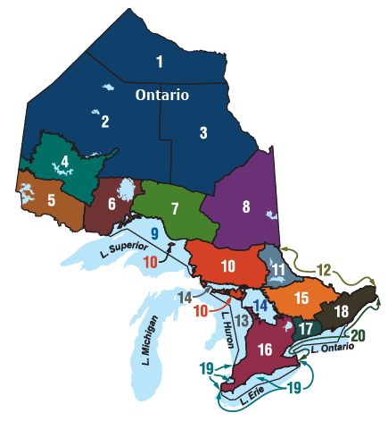
View Fisheries Management Zones (FMZ) map using Fish ON-line.
We're moving content over from an older government website. We'll align this page with the ontario.ca style guide in future updates.
Fishing regulation changes
Fishing regulation changes KetehPetersNew regulations and information in this Recreational Fishing Regulations Summary have been listed on this page and link to the corresponding section within this Summary for your convenience. In the print and PDF versions of this Summary these changes are highlighted in bold red font.
Updates for anglers
Changes FMZ 6:
- changes to the list of lake trout and rainbow trout waterbodies in additional fishing opportunities
Changes FMZ 7:
- changes to the list of brook trout waterbodies in additional fishing opportunities
- opening Borealis Lake as part of the three-year aurora trout rotational cycle
Changes FMZ 8:
As part of the three-year aurora trout season rotational cycle:
Changes FMZ 10:
- changes to the list of lake trout waterbodies in additional fishing opportunities
Changes FMZ 11:
- changes to extend dip netting season for cisco (lake herring) and lake whitefish to apply to all waters where angling is permitted in Zone 11
Changes FMZ 17:
- changes to the extended fall season for Atlantic salmon, brown trout, Pacific salmon and rainbow trout in the Ganaraska River
- new fish sanctuary:
- no fishing from September 1 to October 14
- Ganaraska River: from the south side of the Jocelyn Street Bridge to the southerly limit of the C.N.R. right-of-way
We're moving content over from an older government website. We'll align this page with the ontario.ca style guide in future updates.
Recreational fishing licences and fees
Recreational fishing licences and fees KetehPetersMost people require a recreational fishing licence or deemed licence to legally fish in Ontario. If you purchased a recreational fishing licence, other than a 1-day licence, you must carry your Outdoors Card when fishing. You must carry your licence summary if the current fishing licence is not listed on the Outdoors Card or if you have not yet received your Outdoors Card. If requested, you must present these documents to a conservation officer. An Outdoors Card is a plastic, wallet-sized card valid for 3 calendar years and used for administration purposes.
A licence summary is a document that lists all valid fishing and hunting licences. The licence summary can be either a printed copy or saved as a digital format.
Digital format: You can carry your licence summary in a digital format, such as on a mobile device. You can have a copy of your licence summary sent to your email address by accessing your account using the Fish and Wildlife Licencing Service. If you choose to carry your licence summary on your mobile device, it must be in the PDF format provided to you from the Fish and Wildlife Licensing Service (a photograph or screenshot of your licence summary is not valid). You are responsible for ensuring that your device has battery power and is protected from the elements to be able to display it when and where requested by a conservation officer (unless you are also carrying a paper copy with you).
The province of Ontario sells 2 different types of recreational fishing licences.
- Sport fishing licence: For anglers who want full catch and possession fishing privileges. In this summary, S refers to limits under a sport fishing licence (such as S-4 = catch and possession limit of 4).
- Conservation fishing licence: A reduced catch and possession limit licence that is ideal for anglers who want to live-release the majority of fish caught. In this summary, C refers to limits under a conservation fishing licence (for example, C-2 = catch and possession limit of 2).
Contact us: For more information on purchasing an Ontario fishing licence, visit Fish and Wildlife Licensing Service or call the Natural Resources Information and Support Centre at
Residency definitions
- Ontario resident:
- A person whose primary residence is in Ontario and has lived in Ontario for a period of at least 6 consecutive months during the 12 months immediately before applying for a licence. This also includes a member or civilian employee of the RCMP or Canadian Armed Forces, or their immediate family, who is stationed and resides in Ontario for at least one month.
- Canadian resident:
- A person who is not an Ontario resident, whose primary residence is in any part of Canada and has lived in Canada for a period of at least 6 consecutive months during the 12 months immediately before applying for a licence.
- Non-Canadian resident:
- A person who is neither an Ontario nor Canadian resident.
When you don’t need to purchase a fishing licence — Deemed licences
Instead of purchasing and carrying an Outdoors Card and recreational fishing licence, persons described below carrying the specified documents while fishing may use them as a fishing licence. Catch and possession limits for a sport fishing licence apply in these situations.
Regardless of residency, a person who has been issued any of the following documents may use it as a fishing licence:
- an accessible parking permit issued under Ontario’s Highway Traffic Act
- the Canadian National Institute for the Blind (CNIB) national identity card
The persons described below can carry a licence, permit, certificate or identification card issued by a federal, provincial or territorial government of Canada that indicates their name and date of birth and use it as a fishing licence.
- Ontario and Canadian residents who are under 18 or 65 years of age or older.
- Individuals, regardless of residency, who require the direct assistance of another person to fish and to follow applicable laws due to a disability defined in the Accessibility for Ontarians with Disabilities Act. If the accompanying person is only assisting, they do not require a fishing licence, but must have one if they engage in fishing.
- A person, regardless of residency, who also holds a black and white photocopy or printed version of an accessible parking permit issued under Ontario’s Highway Traffic Act. A visitor who holds an out-of-province accessible parking permit can apply for an Ontario visitor accessible parking permit, more information at get an accessible parking permit.
Ontario residents who are active members or veterans of the Canadian Armed Forces can use one of the following documents as a fishing licence:
- Canadian Forces Identification Card (NDI 20)
- Record of Service Card (NDI 75)
- Canadian Armed Forces Veteran’s Service Card (NDI 75)
Family fishing opportunities
Ontario and Canadian residents are also provided 4 opportunities throughout the year to fish without having to purchase a fishing licence. These dates include:
- Family Fishing Weekend (February 15–17, 2025)
- Mother’s Day Weekend (May 10–11, 2025)
- Father’s Day Weekend (June 14–15, 2025)
- Ontario Family Fishing Week (June 28–July 6, 2025)
Anglers participating in family fishing opportunities must carry government issued identification and must follow catch and possession limits for conservation fishing licences. For more information on these fishing opportunities, contact the Natural Resources Information and Support Centre at
Requirements for Indigenous persons
Many Indigenous communities in Ontario hold Aboriginal or treaty rights to fish. We are committed to respecting these constitutionally-protected rights. After conservation goals are met, Aboriginal and treaty rights to fish take priority before allocation and management of the resource for other purposes.
Aboriginal rights to fish stem from customs, practices or traditions that are integral to the distinctive culture of an Indigenous community. Treaty rights to fish are reserved through treaties between the Crown and Indigenous peoples. Aboriginal and treaty rights are collectively held and are associated with an Indigenous community’s traditional or treaty territory. These rights are not generic and different communities may hold different rights.
Aboriginal and treaty rights to fish can be exercised using modern means.
Members of Indigenous communities exercising an Aboriginal or treaty right generally do not require an Outdoors Card and Ontario fishing licence when fishing for food, social or ceremonial purposes within their traditional or treaty territory. Indigenous individuals should be prepared to provide identification showing their community membership if requested by conservation officers. Members of Indigenous communities fishing outside of their traditional or treaty area must hold a valid fishing licence and follow the corresponding seasons, limits, slot sizes and gear restrictions, or have permission from a First Nation to fish within their traditional or treaty territory. Licensing requirements are also applicable to members of Indigenous communities from the United States who do not have Aboriginal or treaty rights in Ontario. Non-Indigenous people fishing with Indigenous people must have a licence and follow appropriate regulations when fishing on their own behalf.
Non-Canadian residents
Anyone who is not an Ontario or Canadian resident is considered a non-Canadian resident for the purposes of fishing licence regulations. Most non-Canadian residents require an Outdoors Card and recreational fishing licence to fish in Ontario, including those 65 years of age or older. In addition to the general exceptions, the following exceptions apply:
- Non-Canadian residents under 18 years of age may fish without an Outdoors Card and licence if accompanied by a person who has a valid Ontario recreational fishing licence. Any fish kept are part of the catch and possession limit of the person who holds the licence. Alternatively, non-Canadian residents under 18 years of age may purchase an Outdoors Card and recreational fishing licence to have their own limits.
- Non-Canadian youth, under 18 years of age, attending an organized camp may use a government issued photo identification (or a photocopy) together with a camp identification card as a deemed licence to fish. The camp identification card must state the name and location of the camp, the name and date of birth of the camper and the dates that the camper is at the camp.
- For the purpose of these rules, an organized camp means a camp for youth under 18 years of age operated for recreational or educational purposes which provides accommodation and meals for a minimum of five campers at a time.
- These campers fishing under a deemed licence must follow Conservation Fishing Licence limits.
Non-Canadian residents camping on Crown lands in certain areas of Northwestern Ontario are subject to conservation fishing licence limits. Read Crown Land Camping Regulations for more details.
Applying for your Outdoors Card and licence
An Outdoors Card will be automatically mailed to you after you have completed your card purchase. The delivery time for an Outdoors Card is approximately 20 days. You will be able to fish while you wait for your Outdoors Card to arrive in the mail by carrying your licence summary, which lists your valid Outdoors Card and your fishing licence. If you’ve applied for an Outdoors Card and haven’t received it within the stated timeframe or have additional questions related to your Outdoors Cards, call
Note the following rules:
- All fishing licence products are issued on a calendar year basis from January 1 to December 31.
- You must notify us within 10 days of any changes to your name, contact information, address and/or residency. You can update your information by calling
1-800-387-7011 , or online. - Your Outdoors Card, recreational fishing licence or licence summary is not transferable to another person – they provide privileges to you alone.
- Regardless of the date of purchase, a 1-year fishing licence expires on December 31 of the year printed on the licence, while a 3-year fishing licence expires on December 31 of its third year.
- It is against the law to attempt to obtain more than one Outdoors Card or provide false information when applying for your Outdoors Card, recreational fishing licence or licence summary.
- If your Outdoors Card, recreational fishing licence or licence summary is lost or stolen, you can reprint your licence summary online at no charge and/or order a replacement plastic card for a fee. You can also visit a local licence issuer or participating ServiceOntario centre that offers our services for replacement.
- Anglers are able to purchase their Outdoors Card and fishing licences online.
- Outdoors Cards are not required when purchasing a 1-day licence.
Licence fees
The 2025 annual licence fees are in effect until December 31, 2025. For the location of the licence issuer nearest you, visit get an Outdoors Card and licence summary or call
The following licences are available online or through all licence issuers or participating ServiceOntario locations. A 3-year sport and conservation fishing licence can also be purchased through our automated telephone line at
Some anglers may use other documents instead of purchasing and carrying an Outdoors Card and recreational fishing licence. Learn more: fishing licence (Canadian residents).
All products with a fee are subject to 13% HST.
Outdoors Card
| Licence | Fees |
|---|---|
| Outdoors Card | $8.57 |
Ontario residents:
| Licence | Fees |
|---|---|
| three-year sport fishing licence | $79.71 |
| one-year sport fishing licence | $26.57 |
| one-day sport fishing licence (you do not need an Outdoors Card) Valid for 1 calendar day starting at 12:00 a.m. | $12.21 |
| three-year conservation fishing licence | $45.21 |
| one-year conservation fishing licence | $15.07 |
Canadian residents:
| Licence | Fees |
|---|---|
| three-year sport fishing licence | $167.43 |
| one-year sport fishing licence | $55.81 |
| one-day sport fishing licence (you do not need an Outdoors Card) Valid for 1 calendar day starting at 12:00 a.m. | $15.21 |
| three-year conservation fishing licence | $100.29 |
| one-year conservation fishing licence | $33.43 |
Non-Canadian residents:
| Licence | Fees |
|---|---|
| three-year sport fishing licence | $249.57 |
| one-year sport fishing licence | $83.19 |
| one-day sport fishing licence (you do not need an Outdoors Card) Valid for 1 calendar day starting at 12:00 midnight | $24.86 |
| eight-day sport fishing licence | $54.38 |
| three-year conservation fishing licence | $158.13 |
| one-year conservation fishing licence | $52.71 |
| eight-day conservation fishing licence | $31.52 |
We're moving content over from an older government website. We'll align this page with the ontario.ca style guide in future updates.
General fishing regulations
General fishing regulations KetehPetersGlossary of terms
- Additional fishing opportunities
- There are some waters where regulations for certain species are more liberal than the zone regulations and provide anglers with increased limits and or extended seasons. These additional fishing opportunities are often provided through fish stocking.
- Aggregate (combined) limits
- Aggregate or combined limits are catch and possession limits for a combination of fish species. Where there are aggregate limits, you may not catch and retain a separate limit of each species. In this summary, aggregate limits are referred to as combined limits and apply to walleye and sauger, largemouth and smallmouth bass, and black and white crappie.
- Aggregate limits for trout and salmon (including splake)
- There are standard aggregate limits for all species of trout and salmon in combination. Anglers holding a sport fishing licence may only catch and keep (in one day), or possess, no more than 5 fish from trout and salmon species combined. Anglers holding a conservation fishing licence may only catch and keep (in one day), or possess, no more than 2 fish from trout and salmon species combined. In addition to the aggregate limit, you may not exceed individual species limits where they are otherwise stated.
- Angling
- Angling means fishing with a line that is held in the hand or attached to a rod that is held in the hand or closely attended.
- Artificial fly
- An artificial fly means a single or multi-pointed hook dressed with lightweight silk, wool, fur, feathers or similar material, but does not include other types of artificial lures or organic bait. Wet flies, dry flies and streamers are all considered artificial flies.
- Artificial lure
- An artificial lure means a spoon, plug, jig, artificial fly or other such device that is designed to catch fish by means of angling.
- Bait
- Bait includes live or dead animals, plants or parts. The use of any form of bait is not allowed in some areas of the province. Anglers should always check for bait restrictions in waters they plan to fish within.
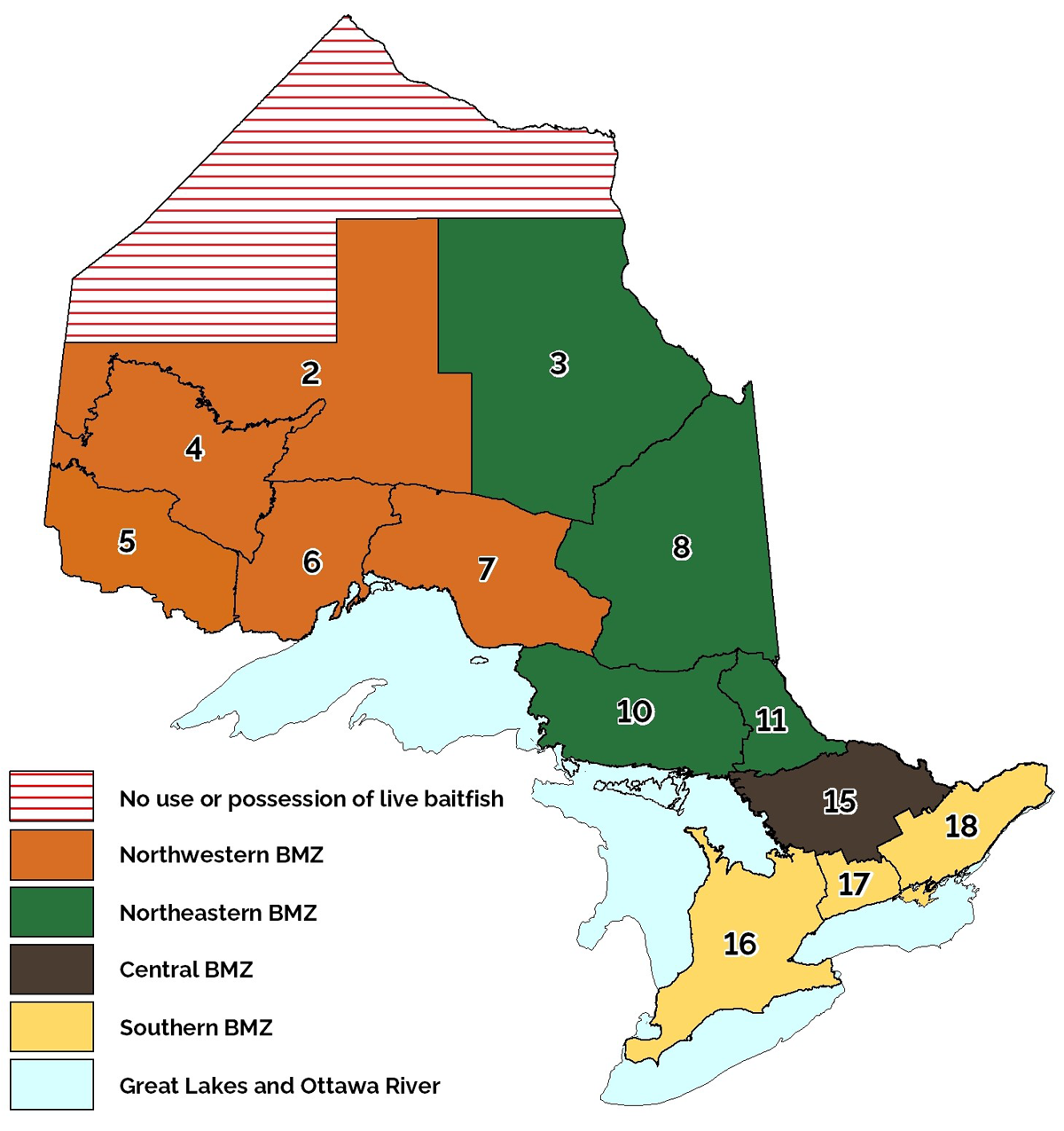
- Bait Management Zone
- In Ontario, 4 Bait Management Zones (BMZ) limit the movement, possession, and use of baitfish and leeches. The Great Lakes (including Manitoulin Island) and Ottawa River are not considered BMZs. Go to bait for more details.
- Baitfish
- Only permitted species of fish may be used live as bait. Go to bait for a list of permitted species.
- Barbless hook
- A barbless hook means a hook without barbs or one that has barbs that are compressed so as to be completely in contact with the shaft of the hook.
- Catch and possession limits
The catch limit is the number of fish you are allowed to catch and keep in one day. It includes fish that are not immediately released and any fish eaten or given away. Catch limits apply to each individual and any fish gifted to another person count towards your catch limit even if they are gifted to a member of your fishing party.
The possession limit is the number of fish you are allowed to have in your possession on hand, in cold storage, in transit or anywhere. Possession limits are the same as one day’s catch limit except where otherwise specified. If you catch a fish after reaching the daily catch or possession limit for that species, the fish must be released immediately.
- Catch and Release Seasons
- It is against the law to target species when the season is closed. If there is an open season but the limit is zero (catch and release only), anglers may target the species but any fish caught must be released immediately, and if alive, in a manner that causes the least harm.
- Check stations
- Conservation officers operate random fish check stations throughout the year. At these stations, conservation officers collect information on fish taken and make sure that regulations are being followed in order to better manage our fisheries resources. Remember to keep all licences, equipment and fish easily accessible for inspection.
- Conservation officers
Conservation officers promote the use and enjoyment of natural resources to all resource users across Ontario, educating the public about the rules that protect natural resources and public safety and enforcing fisheries regulations. They have powers of inspection, arrest, search and seizure under the various statutes they enforce, including the Fish and Wildlife Conservation Act and the Fisheries Act. When carrying out their duties, conservation officers may:
- stop and inspect a vehicle, boat or aircraft
- ask questions relevant to the inspection
- inspect buildings or other places
- require assistance to complete inspections
- enter onto private property to perform their duties
- search with a warrant
- search without a warrant in circumstances requiring immediate action
- seize items related to an offence
- arrest anyone they believe has committed, is committing, or is about to commit an offence
- Crappie
- For the purpose of this summary, crappie includes both black crappie and white crappie.
- Exceptions
In specified waterbodies or for particular species, there are exceptions to the general zone regulations. These include species exceptions (such as size, limits, seasons), waterbody exceptions (such as a combination of species exceptions, fish sanctuaries, gear or bait restrictions), bait restrictions and fish sanctuaries.
Some waters are grouped with other waters that have the same regulatory exceptions and these will generally be listed under the proper name for the largest or most significant water body. If there is nothing stated in the exceptions, then the regulations for the zone apply.
- Export of fish
- A person may not take more than the designated limits of fish when leaving Ontario.
- Fish sanctuaries
- No fishing of any kind is permitted in a fish sanctuary. Some bodies of water, or parts of them, are declared fish sanctuaries for all or part of the year. Fish sanctuaries are not always marked with signs. Sanctuary dates are inclusive: all dates including the first and last dates stated in the summary are closed.
- Fisheries Management Zone or Zone
- The province is divided into 20 Fisheries Management Zones (FMZs) for which there are general regulations that establish seasons, limits and size limits for sport fish species.
- Hook
- A hook includes a single-pointed or multiple-pointed hook on a common shaft but does not include a snagger or spring gaff. The number of hooks includes any single-pointed or multiple-pointed hooks that are part of a lure.
- Hooks and lines
- An angler may use only one line, unless otherwise stated in the regulations. Two lines may be used when angling from a boat in parts of the Great Lakes and for ice fishing in many areas. A fishing line must not have more than 4 hooks attached.
- Immediate release of fish
- All fish that are caught unlawfully or are illegal to possess (such as during a closed season, prohibited size or exceeding the catch and possession limits) must be immediately released at the place and time of capture. This includes fish that may be injured (even fatally) during catch. This rule does not apply to regulated invasive species (such as round goby), which should be destroyed and not released back into any waters. For a list of regulated invasive species, go to Invasive species in Ontario.
- Lead sinkers and jigs
- It is illegal to use or possess lead fishing sinkers or jigs in Canada’s national parks and national wildlife areas.
- Live holding boxes
- If you use a live holding box or impounding device, it must be clearly marked with your name and address and it must be legible without having to lift the box, unless it forms part of or is attached to a boat. Fish in holding boxes are part of your catch and retain or possession limits. Always monitor the health of fish in your possession; allowing fish to spoil is against the law.
- Live release boats
- Operators of live release boats used for competitive fishing events must have a special licence to transport the catches of multiple anglers and to be in possession of more than an individual’s possession limit of fish.
- Livewell
- A livewell is a compartment designed to keep fish alive. It must be attached to or form part of a boat, hold a total volume of not less than 46 litres (10 gallons) of water, have the capacity for water exchange and be aerated at all times when live fish are being held in it. Livewells should be drained and emptied of all contents, including live fish, before being transported overland.
- Muskellunge
- For the purposes of this summary, muskellunge includes muskellunge and hybrids of muskellunge and northern pike.
- Open seasons
- Fishing season opening and closing dates vary depending on the species and the area. Dates are inclusive: all dates including the first and last dates stated in the summary are open or closed. It is illegal to attempt to catch fish for which the season is closed, even if you are going to release them. Fish accidentally caught during the closed season must be immediately released back to the water. Unless stated otherwise, species that are not listed (such as rock bass) have a year-round open season for angling.
- Pacific salmon
- For the purpose of this summary, Pacific salmon include chinook salmon, coho salmon and pink salmon.
- Plant-based bait
Bait made from one of the following:
- bait that is made entirely from plants (such as corn)
- primarily from plants (such as boilies and doughballs), and cannot: contain visible pieces of fish or animal parts, be fish or animal flavoured, or include poultry eggs (except if they are used to bind ingredients together)
- Primary residence
- The place with which a person has the greatest connection in terms of present and anticipated future living arrangements and the activities of daily living. For greater clarity, a person may only have one primary residence. Go to bait for more details.
- Size limits
- Size limits refer to total length which is a measure from the tip of the mouth with the jaws closed to the tip of the tail, with the tail fin lobes compressed to give the maximum possible length.
- Sunfish
- For the purpose of this summary, sunfish includes pumpkinseed, bluegill, green sunfish, northern sunfish, orange-spotted sunfish and their hybrids.
- Units of measure
- Provincial regulations use the metric system. Converting from imperial units to metric units can be done using the following conversion ratios:
- 1 inch is equal to 2.54 centimetres
- 1 foot is equal to 0.305 metres
- 1 mile is equal to 1.609 kilometres
General prohibitions
In Ontario, it is illegal to:
- Import any crayfish, salamanders, live fish or leeches for use as bait, or transport any live or dead baitfish or leeches into or out of a BMZ (exceptions). Contact the Canada Food Inspection Agency (CFIA) or Canada Border Services Agency (CSBA) to confirm federal import rules related to bait (including earthworms)
- Transport live fish, other than baitfish, taken from Ontario waters or to transfer or stock any live fish or spawn into Ontario’s waters without a special licence to transport or stock fish
- Fish for or possess any species of fish listed as Endangered or Threatened under the provincial Endangered Species Act and/or federal Species at Risk Act
- Sell or buy any recreationally caught fish (including taxidermy mounts), crayfish, leeches, frogs or fish eggs. Only holders of commercial fishing or commercial bait licences may sell their catch
- Take fish with a gaff, snare, snagger or spear gun, or possess a spring gaff, snagger or spear gun, or a snare for the purpose of fishing, within 30 metres of any waters. A spear is only permitted within 30 metres of any waters when it is being used in accordance with non-angling methods of capturing fish. A gaff, other than a spring gaff, may be used to assist in landing fish caught by lawful means. A spring gaff includes any device which uses a mechanical spring, other than the fishing rod under tension, to set the hook for an angler
- Catch or retain a fish by impaling or snagging it with a hook through any part of the body other than the mouth. Fish hooked in this way must be released immediately
- Take fish by any means other than angling, spear, bow and arrow, dip or seine net or baitfish trap. Go to non-angling methods of capturing fish and bait for more details
- Use artificial lights to attract fish except when fishing for rainbow smelt, lake whitefish or lake herring (cisco) using a dip net or if the light is part of a lure attached to a line used in angling
- Use dynamite or other explosives to take or destroy fish
- Fish within 25 metres of a pound net or cage in which fish are held for culture
- Fish in any manner within 23 metres downstream from the lower entrance to any fishway, obstruction, or leap
- Abandon fish or permit the flesh to spoil, if the fish is suitable for human consumption
Provincial possession limits
Provincial possession limits restrict the total number of fish of a given species a person can have in their possession (including storage) which have been harvested from more than 1 zone. They may differ from zone limits which restrict the number of fish an individual can catch and retain from a specific zone. Aggregate limits for trout and salmon (including splake) also apply. Always check the regulations for the zone you are fishing in to ensure that you aren’t exceeding the catch and possession limits for that zone. The provincial possession limits are as follows:
- Atlantic salmon: 1
- aurora trout: 1
- brook trout: 5
- brown trout: 5
- channel catfish: 12
- crappie: 30
- lake trout: 3
- lake whitefish: 25
- largemouth or smallmouth bass combined: 6
- muskellunge: 1
- northern pike: 6
- Pacific salmon: 5
- rainbow trout: 5
- splake: 5
- walleye or sauger combined: 6
- yellow perch: 100
Catch and retain rules
Generally, daily catch limits include all fish that are retained for any period of time and not immediately released.
Anglers fishing from a boat may catch, hold, and selectively live release more walleye, northern pike, largemouth or smallmouth bass than the daily limit, provided:
- the fish are held in a livewell with a mechanical aerator operating at all times
- the fish comply with any applicable size limits
- the sport or conservation fishing licence daily catch and retain limits for walleye or northern pike are not exceeded at any one time
- no more than 6 largemouth and smallmouth bass (combined) are held at any one time for fish caught under a sport fishing licence
- the conservation fishing licence catch and retain limits for largemouth and smallmouth bass (combined) are not exceeded at any one time for fish caught under a conservation fishing licence
Anglers are reminded to closely monitor the condition of fish held in a livewell. Only fish that are in such a condition that they will survive may be released. Releasing a fish that will not survive and allowing the flesh of that fish to be wasted is an offence. Any fish not live released are part of your catch and possession limit.
Transporting sport fish
It is illegal to stock fish without a permit or transport live fish overland, other than baitfish, without a permit. Sportfish transported overland must be dead and should be transported on ice, not in a livewell filled with water. Anglers need to ensure they are transporting fish in compliance with the regulations, which are designed to protect fisheries resources. The fish that you catch and keep may be cleaned, but must be readily measurable at all times if they are from waterbodies where size limits exist, unless the fish are:
- being prepared for immediate consumption
- prepared at an overnight accommodation for storage
- being transported on the water from a temporary overnight accommodation to your residence and you are not engaged in sport fishing
- being transported overland
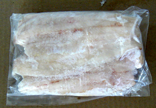
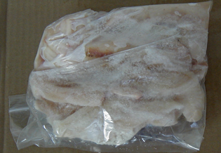
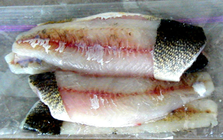
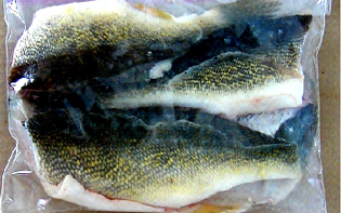
Tips for packaging fish
- All fish must be packaged so that they can be easily counted and identified, not just those with limits.
- To ensure fish can be easily counted, package each fish separately, or arrange fillets spread flat in a clear freezer bag. Do not freeze fillets in container or a large lump frozen together in bags.
- Since anglers often transport or store various species of fish, it is their responsibility to ensure every fillet of their catch can be easily identified. Ensure you leave at least a large patch of skin on all fish fillets for identification purposes. Some species (such as lake whitefish or lake herring (cisco)) may require additional identifying features such as the head.
- Conservation officers may inspect your catch at any time. Always have your fish and your licence easily accessible, and place coolers of fish where they can be easily inspected.
- If a conservation officer inspects fish captured through sport fishing and you are transporting them improperly packaged your catch may be seized for evidence, you could get a ticket and be fined and/or you may have to attend court close to where the inspection took place, which may be far from where you live.
- The following pictures demonstrate examples of improperly packaged fish since they are frozen in a clump, cannot be identified or counted and no skin is attached to the fillets.
- The following pictures demonstrate examples of properly packaged fish since they can be identified and counted easily, the skin is attached to the fillets and they are not frozen in a large clump.
Bullfrogs
Holders of valid recreational fishing licences may catch and retain bullfrogs during the open season. For details on the current harvest areas, season dates and catch and possession limits, go to the Ontario Hunting Regulations Summary.
Ice fishing
Two lines may be used for ice fishing in most waters with some exceptions. When ice fishing, you must be within 60 metres of any line or tip-up and you must have a clear and unobstructed view of the lines at all times. Any spring-loaded device which sets the hook for an angler may not be possessed within 30 metres of any waters.
Ice hut registration
Ice fishing huts in the following Zones must be registered online and removed before these dates:
- March 2: Zones 17 and 20
- March 16: Zones 14, 16, 18, 19 and 12 (below Timiskaming Dam)
- April 1: Zones 9, 10, 11, 15 and 12 (above Timiskaming Dam)
- Removal dates and registration do not apply in Zones 1 to 8 and 13
Once registered, an ice hut can be used anywhere in Ontario. Additional approvals may be required for ice fishing within provincial parks and conservation reserves. Individuals only need to register once. If your ice hut already has a registration number then you do not need to re-register. You do not need to register an ice hut that is a tent made of cloth or synthetic fabric that has a base area of 7 square metres or less when erected.
It is an offence under the Public Lands Act to leave your ice hut out after ice break up, regardless of whether registration and removal dates apply. Ice hut registration numbers must be at least 6.3 centimetres in height and clearly displayed on the outside of the hut.
Multiple lines for common carp
Anglers in zones 12 to 20 may use up to 3 lines while targeting common carp. To use more than 1 line, you must meet all of the following conditions:
- use baits that are plant-based or artificial corn
- when fishing from shore, each line you use must be no further than 2 metres away from another line you are using
- when fishing from a vessel (such as a boat), all lines must be on board the vessel with you
The following are not allowed when fishing with multiple lines for common carp:
- baits like worms, leeches or baitfish
- artificial lures including soft plastic lures
When targeting common carp with more than 1 line (up to 3), the restrictions listed above apply to all lines that an angler is using. Any fish species caught, other than common carp, must be immediately released as defined in the glossary.
Non-angling methods of capturing fish
Ontario and Canadian residents and non-Canadian residents with a valid recreational fishing licence may fish with one dip net, one seine net, one spear or a bow and arrow for the species and during the periods outlined below. If the Zone is not identified below, then there is no open season
for that species.
Dip nets: may be no more than 183 centimetres on each side if angular, or 183 centimetres in diameter if circular.
Seine nets: may be no more than 10 metres long and 2 metres high.
Spears: cannot be possessed on or within 30 metres of the edge of any waterbody except when fishing for carp and white sucker as described within the non-angling methods of capturing fish.
Bow and arrow: includes all long-bows. Long-bows are considered a firearm under the Fish and Wildlife Conservation Act.
People fishing with a longbow who handle or discharge it without due care for people or property may be liable to a fine and/or imprisonment. Any injury requiring treatment by a physician that is caused by the discharge of a firearm while it was possessed for fishing must be reported to a conservation officer.
Bowfin
Season: May 1 to July 31 in Zones 10, 13, 14, 19
Method: bow and arrow during daylight hours only
Limit: no limit
Common carp
Season: May 1 to July 31 in Zones 5, 6, 9, 10, 12, 13, 14, 15 (except Algonquin Park), 16, 18, 19, 20
Season: Second Saturday in May to July 31 in Zone 17
Method: bow and arrow, spear, and dip net during daylight hours only
Limit: no limit
Lake herring (cisco)
Season: October 1 to December 15 in Zones 1, 2, 3, 4, 5, 6, 7, 8, 10, 11, 15 (in designated waters only in Zone 15; contact local work centre for details)
Method: dip net day or night
Limit: no limit
Lake whitefish
Season: October 1 to December 15 in Zones 1, 2, 3, 4, 5, 6, 7, 8, 9, 10, 11, 15 (in designated waters only in Zone 15; contact local work centre for details)
Method: dip net day or night
Limit: same as angling limit in zone
Rainbow smelt
Season: March 1 to May 31 in Zones 6, 7, 8, 9, 10, 11, 12, 13, 14, 15 (except Algonquin Park), 16, 18, 19, 20
Season: second Saturday in May to May 31 in Zone 17
Method: dip net and seine day or night
Limit: no limit
In most areas of Ontario, rainbow smelt are an introduced species and can negatively impact waterbodies. Be careful when cleaning rainbow smelt and do not rinse or dump entrails into a lake or river as fertilized eggs can easily invade new waters.
White sucker
Season: March 1 to May 31 in Zones 1, 2, 3, 4, 5, 6, 7, 8, 9, 10, 11, 12, 13, 14, 15 (except Algonquin Park), 16, 18, 19, 20
Season: second Saturday in May to May 31 in Zone 17
Method: bow and arrow, spear, and dip net during daylight hours only
Limit: no limit
Boundary waters
Anglers who fish in waters that lie both in Ontario and another province or state must include the total number of fish caught anywhere in those waters as part of the number caught and kept or possessed under the Ontario recreational fishing regulations when bringing those fish into Ontario.
Ontario-Quebec boundary
Anglers may fish in the following waters with either an Ontario resident fishing licence or a Quebec resident fishing licence.
- Clarice Lake (48°20′N., 79°32′W.)
- Labyrinth Lake (48°14′N., 79°31′W.)
- Lake St. Francis (45°08′N., 74°25′W.) and the waters of the St. Lawrence River between the easterly side of the dam at the Robert H. Saunders Generating Station and the Ontario-Quebec boundary
- Lake Timiskaming (47°20′N., 79°30′W.)
- Ottawa River (45°34′N., 74°23′W.) lying south of the dam situated in Temiscamingue, Quebec
- Raven Lake (48°03′N., 79°33′W.)
Ontario-Manitoba boundary
Anglers may fish in the following waters with either an Ontario resident fishing licence or Manitoba resident fishing licence and must follow conservation or sport possession limits applicable within their respective province.
- Davidson Lake (50°21′N., 95°09′W.)
- Frances Lake (51°43′N., 95°08′W.)
- Garner Lake (50°48′N., 95°11′W.)
- High Lake (49°42′N., 95°08′W.)
- Mantario Lake (49°95′N., 95°10′W.)
- Moar Lake (52°00′N., 95°07′W.)
- Ryerson Lake (50°23′N., 95°09′W.)
Crown land camping
Most Crown land and conservation reserves in Ontario are available year-round for personal, temporary use, at no cost. Restrictions may apply in some areas as indicated by the posting of signs, or land use planning or management direction. For more information go to the Crown Land Use Policy Atlas or the Provincial parks and conservation reserves planning webpages. In addition, some areas may have restricted travel zones for forest fire prevention, closed access roads or specific areas posted with signs to prohibit all or certain kinds of uses or travel.
Canadian residents
Canadian residents can camp on Crown land and Conservation Reserves for free up to 21 days on any one site in a calendar year. For the purposes of camping on Crown land or a conservation reserve, a resident of Canada includes both Canadian citizens as defined in the Citizenship Act (Canada) or individuals who have resided in Canada for at least seven months during the preceding 12-month period.
Non-Canadian residents
Non-Canadian residents 18 years of age or older, require a permit to camp on Crown land in Northern Ontario (north of the French and Mattawa rivers) and in a conservation reserve anywhere in Ontario. Non-Canadian resident Crown land camping permits are $9.35 plus tax per person per day. In addition to any local access restrictions, non-Canadian residents are also prohibited from camping in designated green zones in Northern Ontario at any time of year. For more information on purchasing a permit, a map of green zones and other requirements related to non-Canadian resident Crown land camping, visit recreational activities on Crown land.
Fishing restrictions for non-Canadian residents
Holders of non-Canadian resident fishing licences who are camping on Crown land in Zones 2, 4, 6 and the portion of Zone 5 that lies outside of the Border Waters Area, may not take fish in excess of the conservation catch and possession limits. Holders of non-Canadian resident fishing licences camping on Crown land in the part of Zone 5 identified as the Border Waters Area must follow the Zone 5 regulations. For more information on the boundary of these waters and applicable fishing limits, contact the nearest ministry office or visit Fisheries Management Zone 5.
There are also exceptions for the Winnipeg River (Zone 5) and the Sydney Lake Area (Zones 2 and 4) that affect non-Canadian resident fishers - go to waterbody exceptions for Zones 2, 4 and 5.
We're moving content over from an older government website. We'll align this page with the ontario.ca style guide in future updates.
Bait
Bait KetehPetersBait Management Zones (BMZ) Map
Ontario is divided into 4 BMZs that limit the movement, possession and use of baitfish and leeches. BMZ boundaries are generally based on FMZ boundaries. The Great Lakes and Ottawa River, as well as portions of the Far North (hatched area on the map below), are not considered BMZs.
Baitfish or leeches, whether live or dead, may not be transported into or out of a BMZ, with some limited exceptions.
- Southern BMZ – consists of FMZs 16, 17, 18 and the part of 20 that is within the County of Prince Edward.
- Central BMZ – consists of FMZ 15.
- Northeastern BMZ – consists of FMZs 3, 8, 10, and 11 except the part of FMZ 10 that is within Cockburn Island, Michipicoten Island, St. Joseph Island, and Manitoulin Island. Manitoulin Island is defined as all islands that can be accessed by land south of the causeway connecting Great LaCloche Island and Whitefish River First Nation (known as Swift Current Bridge), including Manitoulin Island, Great LaCloche Island, Little LaCloche Island, and Barrie Island.
- Northwestern BMZ – consists of FMZ 2 south of the 11th baseline at latitude 51°48’11”N. and east of longitude 89°00’00”W., and FMZs 4, 5, 6, and 7, except the part of FMZ 6 that consists of St. Ignace Island and Simpson Island.
Refer to bait and Fisheries management zones for more information and detailed maps of FMZ boundaries.
Bait
It is illegal to (or attempt to) deposit or release into, or within 30 metres of, any waters:
- live or dead bait or baitfish, including fish eggs, gametes or fish parts
- the water, soil or other materials used to hold any of these items
The capture and use of live bait is not allowed in some waters — always check the rules for the waterbody that you intend to fish.
It is illegal to bring any crayfish, salamanders, live fish or leeches into Ontario for use as bait. Non-residents must purchase bait within the BMZ where it is to be used and retain the receipt (refer to receipts section).
Recent changes regarding the movement and personal harvest of baitfish and leeches in Ontario are outlined in the following sections.
Movement of baitfish and leeches
To help protect our waters from harmful invasive species and fish diseases, 4 BMZs limit the movement, possession, and use of baitfish and leeches (see bait). Baitfish or leeches, may not be transported into or out of a BMZ with some limited exceptions. The following rules apply when using baitfish or leeches for fishing.
Transport exception
To reach a destination in the BMZ that bait was lawfully acquired in, a person may transport bait through an adjacent BMZ only if they use a direct route through the adjacent BMZ.
Receipts
Anglers using or possessing baitfish or leeches for fishing in a BMZ where their primary residence is not located (see general regulations), must obtain them from the holder of a commercial licence and be able to immediately produce a legible receipt upon request by a conservation officer. Baitfish or leeches, whether live or dead, can only be possessed or used within 2 weeks following the date on which they were obtained. The receipt must list the location and date it was obtained from the commercial licence holder, the business name, (if applicable), commercial licence number and quantity of baitfish or leeches obtained.
Receipts are not required when an angler is using baitfish or leeches:
- in the BMZ where their primary residence is located
- in the Great Lakes or Ottawa River
- that are preserved
Receipts are not needed for other forms of bait (such as worms).
Personal harvest
Anglers are only permitted to personally harvest baitfish and leeches in the BMZ where their primary residence is located, or within the Great Lakes or Ottawa River. Bait that is personally harvested within the Great Lakes or Ottawa River must be used in that waterbody and can only be moved into an adjacent BMZ to be disposed of immediately more than 30 metres from the water.
Preserved bait
Preserved baitfish or leeches may be transported into or out of BMZ's if the bait:
- is dead
- has been preserved (treated or prepared in a manner to prevent decay or decomposition) using a method of preservation other than refrigeration or freezing
Great Lakes and the Ottawa River
The Great Lakes and Ottawa River are not considered BMZs, baitfish and leeches may be moved from an adjacent BMZ into the Great Lakes or Ottawa River, provided they are not moved through another BMZ. Baitfish and leeches can only be moved out of the Great Lakes or Ottawa River into an adjacent BMZ to be disposed of immediately more than 30 metres from the water.
With respect to the movement of baitfish and leeches, the Great Lakes and Ottawa River are defined as the folliowing.
Great Lakes
- FMZs 9, 13, 14, 19, and 20, except for the part of FMZ 20 that is within the County of Prince Edward
- The portions of FMZ 6 consisting of St. Ignace Island and Simpson Island
- The portions of FMZ 10 consisting of Cockburn Island, Michipicoten Island, St. Joseph Island, and Manitoulin Island. Manitoulin Island is defined as all islands that can be accessed by land south of the causeway connecting Great LaCloche Island and Whitefish River First Nation (known as Swift Current Bridge), including Manitoulin Island, Great LaCloche Island, Little LaCloche Island, and Barrie Island
Ottawa River
- All of FMZ 12
Dead baitfish species
Dead lake herring (cisco), longnose sucker, and white sucker may be moved into or out of a BMZ only if they are for the purposes of consumption.
Permitted baitfish
Bait regulations protect rare and endangered species, conserve biodiversity and prevent the spread of invasive species. Anglers are responsible to ensure that any live fish in their possession intended for use as bait are permitted baitfish species. Only the fish species listed below are considered permitted baitfish and may be used live as bait.
Minnows:
- blackchin shiner
- blacknose dace (now known as western blacknose dace)
- blacknose shiner
- bluntnose minnow
- brassy minnow
- central stoneroller
- common shiner
- creek chub
- emerald shiner
- fallfish
- fathead minnow
- finescale dace
- golden shiner
- hornyhead chub
- lake chub
- longnose dace
- mimic shiner
- northern redbelly dace
- pearl dace
- redfin shiner
- river chub
- rosyface shiner
- sand shiner
- spotfin shiner
- spottail shiner
- striped shiner
Sticklebacks:
- brook stickleback
- ninespine stickleback
Suckers:
- longnose sucker
- white sucker
Others:
- banded killifish
- central mudminnow
- lake herring (cisco)
- trout-perch
Limits and capture methods
A recreational fishing licence is required to capture baitfish, leeches, crayfish or frogs.
Baitfish
Limit: 120 (includes those caught or purchased)
Ontario and Canadian resident anglers may use non-angling methods to capture all baitfish species while non-residents may only capture longnose sucker, white sucker and lake herring using non-angling methods. Anglers are only permitted to personally harvest baitfish in the BMZ where their primary residence is located, or within the Great Lakes and Ottawa River (must be used in that waterbody, and, unless dead and preserved, can only be moved into an adjacent BMZ to be disposed of immediately more than 30 metres from the water). Only the following non-angling methods may be used.
- One baitfish trap no more than 51 centimetres long and 31 centimetres wide can be used day or night. Baitfish traps must be clearly marked with the licence holder’s name and address.
- One dip-net no more than 183 centimetres on each side if angular or 183 centimetres across if circular, during daylight hours only (after sunrise and before sunset).
Dip-nets and baitfish traps may not be used in Algonquin Park.
Leeches
Limit: 120 (includes those caught or purchased)
Only Ontario and Canadian resident anglers may capture leeches. Anglers are only permitted to personally harvest leeches in the BMZ where their primary residence is located or within the Great Lakes and Ottawa River (must be used in that waterbody, and can only be moved into an adjacent BMZ to be disposed of immediately more than 30 metres from the water). Only the following methods may be used.
- Only one leech trap no more than 45 centimetres in any dimension can be used day or night to capture leeches. Leech traps must be clearly marked with the licence holder’s name.
Crayfish
Limit: 36
- Must be used in same waterbody where caught.
- May not be transported overland.
- May be captured using methods outlined for baitfish above.
Frogs
Limit: 12
- Only Northern leopard frogs may be captured or used as bait.
Salamanders
- May not be captured, imported or used as bait in Ontario.
Chumming
Chumming (baiting an area to attract fish) is allowed for common carp and for attracting other fish species, but only with plant-based baits as defined in general fishing regulations.
We're moving content over from an older government website. We'll align this page with the ontario.ca style guide in future updates.
Invasive species and viral hemorrhagic septicemia (<abbr>VHS</abbr>)
Invasive species and viral hemorrhagic septicemia (VHS) JiayiLiInvasive species
Invasive species are often spread unknowingly. Anglers and boaters need to be aware of the rules that apply to them and should always take precautions to help stop invasive species. Ontario’s Invasive Species Act, 2015 regulates activities to prevent the introduction and spread of species that negatively affect Ontario’s biodiversity and/or economy. Federal regulations also prohibit the introduction of all aquatic species to an area where they are not naturally found.
For more information on invasive species in Ontario, visit Invasive species in Ontario. To report a sighting call the Invading Species Hotline
Prohibited invasive species
In Ontario, it’s illegal to import, possess, deposit, release, transport, breed, grow, buy, sell, lease or trade these species.
Fish:
- bighead carp
- black carp
- Eastern and Western mosquito fish
- grass carp
- ide
- Prussian carp
- red shiner
- silver carp
- snakeheads (all species in the snakehead family)
- stone moroko
- tench
- wels catfish
- zander
Invertebrates:
- common yabby (a crayfish)
- genus pacifastacus (all crayfish in the pacifasticus genus)
- genus procambarus (all crayfish in the procambarus genus) including marbled and red swamp crayfish
- golden mussel
- killer shrimp
- New Zealand mud snail
Plants:
- Brazilian elodea (Brazilian waterweed)
- European water chestnut
- hydrilla
- oxygen weed
- parrot feather
- water soldier
- watermoss (genus salvinia)
Additionally, it’s against the law to possess, transport or release live round goby, tubenose goby, rudd or ruffe in Ontario or to import zebra or quagga mussels into Canada.
Restricted invasive species
In Ontario, the following aquatic plant species are illegal to import, breed, grow, buy, sell, lease or trade, or to possess or transport within a provincial park or conservation reserve:
- Carolina fanwort
- Eurasian water-milfoil
- European frogbit
- floating primrose-willow
- flowering rush
- genus azolla
- invasive phragmites
- yellow floating heart
Sale of prohibited invasive species
Only the following prohibited invasive species may be imported, possessed, transported, bought or sold:
- dead and eviscerated (gutted) bighead carp, black carp, grass carp, Prussian carp, silver carp, tench, zander or snakeheads
- dead red swamp crayfish, white river crayfish and signal crayfish that have been prepared for human consumption (such as cooked)
Boating rules
It is illegal to transport watercraft and watercraft equipment (anything that is used to aid in the operation, movement or navigation of a watercraft including ropes, fenders or anchors) overland unless:
- drain plugs or other devices used to control drainage have been removed or opened to allow water to drain out
- reasonable measures have been taken to remove any aquatic plants, animals, or algae from the watercraft, watercraft equipment, vehicle, and trailer
Persons who move watercraft or watercraft equipment overland must additionally ensure that prior to arriving at a launch site or placing a watercraft in any body of water, the watercraft, watercraft equipment, vehicle, and trailer are free of all aquatic plants, animals, and algae.
In addition to the rules above, if you are boating in waterbodies where European water chestnut or water soldier plants exist, you must:
- take reasonable precautions to prevent transport and deposit of plants outside the infested area to other parts of the waterbody (such as avoid boating through the infested area if you can)
- dispose of these plants so they don’t end up back in any waterbody
In general, avoid running boats through aquatic plants as propellers can break aquatic plants loose and spread invasive species.
Fishing
If you happen to catch a prohibited fish, invertebrate or plant, you must immediately destroy it in a way that ensures it cannot reproduce or grow.
Round goby
Round goby have become widely established in Southern Ontario and Lake Huron and have negative impacts on native fish. It is illegal to use gobies as bait or have live gobies in your possession. Anglers should know how to identify round goby since these aggressive fish are easily caught by hook and line. If you catch a round goby it should be destroyed as it cannot be released live into any waters. Report any new sightings.
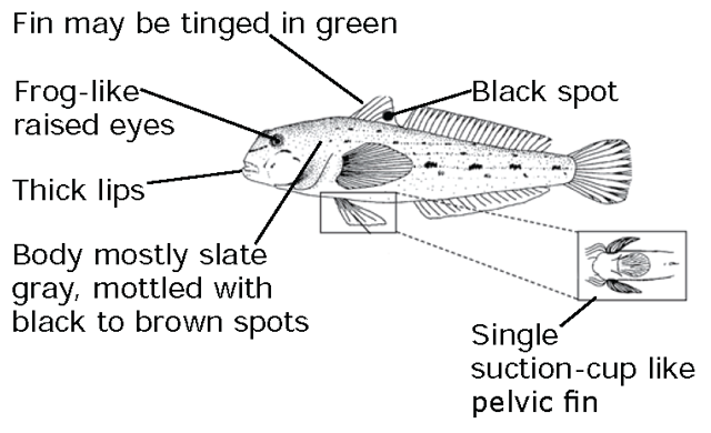
Credit: Donna Francis
Help slow the spread of Viral Hemorrhagic Septicemia (VHS)
VHS is an infectious disease of fish that has been documented in Ontario. Infected fish may show some of the following signs:
- pale gills and organs
- bloated abdomen
- bulging eyes
- bleeding of the body and organs
- a darker body colour
VHS is not a threat to human health. Fish carrying the VHS virus are safe to eat and handle.
More information is available at Viral Hemorrhagic Septicemia or call the Natural Resources Information and Support Centre at
We're moving content over from an older government website. We'll align this page with the ontario.ca style guide in future updates.
Fisheries Management Zone 1
Fisheries Management Zone 1 KetehPeters
View Fisheries Management Zone 1 map using Fish ON-line or PDF.
General information
- Refer to general fishing regulations for more information on how to use this summary.
- In Zone 1, only one barbless hook may be used and live fish may not be used as bait or possessed for use as bait.
- The following species are not present in this Zone and are closed to fishing all year:
- Atlantic salmon
- brown trout
- channel catfish
- crappie
- largemouth and smallmouth bass
- muskellunge
- rainbow trout
- splake
- sunfish
- Pacific salmon
Zone-wide seasons and limits
Aggregate limits for trout and salmon (including splake)
Limits: S-5 and C-2; total daily catch and possession limit for all trout and salmon species combined
Brook trout
Season: January 1 to September 30
Limits: S-5 and C-2; not more than one greater than 40 centimetres
Lake sturgeon
Season: January 1 to April 30 and July 1 to December 31
Limits: S-0 and C-0
Lake trout
Season: Open all year
Limits: S-3 and C-1
Lake whitefish
Season: Open all year
Limits: S-12 and C-6
Northern pike
Season: Open all year
Limits: S-6; not more than two greater than 61 centimetres, of which not more than one greater than 86 centimetres, and C-2; not more than one greater than 61 centimetres, none greater than 86 centimetres
Walleye and sauger combined
Season: Open all year
Limits: S-4 and C-2; not more than one greater than 46 centimetres
Yellow perch
Season: Open all year
Limits: S-50 and C-25
We're moving content over from an older government website. We'll align this page with the ontario.ca style guide in future updates.
Fisheries Management Zone 2
Fisheries Management Zone 2 KetehPetersView Fisheries Management Zone 2 map using Fish ON-line or a PDF.
- The part of the Berens River that is between Zone 2 and Zone 4, is wholly within Zone 4.
General information
- Refer to general fishing regulations for more information on how to use this summary.
- Non-Canadian residents camping on Crown land must follow conservation fishing licence limits.
- Rainbow smelt may not be used as bait or possessed for use as bait, except in the tributaries of Lake Nipigon within FMZ 2.
- Live fish may not be used as bait or possessed for use as bait in all waters north of the 11th baseline at latitude 51°48′11″ N. and west of longitude 89°00′ W.
- The following waterbodies, or portions of them, have different regulations that are listed in the waterbody exceptions:
- Lake St. Joseph
- Opapimiskan Lake
- Sydney Lake area
- The following species are not present in this Zone and are closed to fishing all year:
- Atlantic salmon
- channel catfish
- crappie
- Pacific salmon
- The portion of FMZ 2 that is south of the 11th baseline at latitude 51°48′11”N. and east of longitude 89°00′ W. is part of the Northwest Bait Management Zone (BMZ). Live or dead baitfish or leeches may not be transported into or out of a BMZ. These rules do not apply to baitfish and leeches which are both dead and preserved. Refer to bait for more details.
Zone-wide seasons and limits
Zone-wide seasons and limits apply to all waters in the Zone except for the specific waters and species listed in the species exceptions, waterbody exceptions and fish sanctuaries.
Aggregate limits for trout and salmon (including splake)
Limits: S-5 and C-2; total daily catch and possession limit for all trout and salmon species combined
Brook trout
Season: January 1 to Labour Day
Limits: S-5 and C-2; not more than one greater than 30 centimetres
Brown trout
Season: open all year
Limits: S-5 and C-2
Lake sturgeon
Season: January 1 to April 30 and July 1 to December 31
Limits: S-0 and C-0
Lake trout
Season: January 1 to September 30
Limits: S-2; not more than one greater than 56 centimetres from September 1 to September 30, no size limit rest of season and C-1; any size
Lake whitefish
Season: open all year
Limits: S-12 and C-6
Largemouth and smallmouth bass combined
Season: open all year
Limits: S-2 and C-1; must be less than 35 centimetres from January 1 to June 30 and December 1 to December 31, S-4 and C-2; no size limit from July 1 to November 30
Muskellunge
Season: third Saturday in June to December 15
Limits: S-1; must be greater than 91 centimetres and C-0
Northern pike
Season: open all year
Limits: S-4 and C-2; none between 70 centimetres to 90 centimetres, not more than one greater than 90 centimetres
Rainbow trout
Season: open all year
Limits: S-5 and C-2
Splake
Season: open all year
Limits: S-5 and C-2
Sunfish
Season: open all year
Limits: S-50 and C-25
Walleye and sauger combined
Season: January 1 to April 14 and third Saturday in May to December 31
Limits: S-4 and C-2; not more than one greater than 46 centimetres
Yellow perch
Season: open all year
Limits: S-50 and C-25
Species exceptions
Brook trout
Additional fishing opportunities
Season: open all year
Limits: S-5 and C-2; no size limits
- Blue Lake (50°20′04″ N., 88°56′56″ W.)
- Johnny Lake (50°17′35″ N., 87°02′52″ W.)
- Secret Lake (50°18′53″ N., 88°58′29″ W.)
- Unnamed Lake (Whiz Lake) (51°38′11″ N., 89°58′01″ W.)
Lake sturgeon
Season: closed all year
- All waters located within the portion of Zone 2 from the Ontario/Manitoba interprovincial boundary east along the line of 52°35′N. latitude, to the intersection with 93°50′ W. longitude, thence south to the intersection with 52°10′N. latitude, thence east to the intersection with 92°10′ W. longitude, thence south to the Zone 2 boundary, including all of the waters within Woodland Caribou Provincial Park; thence in a westerly direction to the Ontario/Manitoba interprovincial boundary, thence northerly to the intersection with 52°35′N. latitude.
- All waters in Zone 2 draining into Lake Nipigon including the Little Jackfish River beginning at the hydro control dam at Mojikit Lake.
Lake trout
Limits: S-1 and C-0
- Faircloth Lake (Greytrout Lake) (51°09′20″ N., 88°11′24″ W.)
- Merpaw Lake (51°38′53″ N., 88°58′13″ W.)
Limits: S-1 in one day and possession limit of two, not more than one greater than 65 centimetres and C-1; any size
- Echoing Lake (54°31'14" N., 92°14'24" W.)
Limits: S-2 and C-1; not more than one greater than 56 centimetres
- Gordon Reid Lake (South Lake, I-100 Lake) (51°01′14″ N., 88°02′37″ W.)
- Luella Lake (51°11′20″ N., 88°42′26″ W.)
- Opichuan Lake (51°14′46″ N., 87°46′14″ W.)
- O’Sullivan Lake (50°25′00″ N., 87°03′00″ W.)
- Superb Lake (50°30′55″ N., 86°58′21″ W.)
- Troutfly Lake (51°41′59″ N., 88°53′22″ W.)
Walleye and sauger combined
Season: January 1 to April 14 and June 10 to December 31
Limits: S-2 and C-2; not more than one greater than 46 centimetres
- Little Jackfish River - downstream from and including the first rapids upstream of the Pikitigushi Road Bridge to the centre line of the CN railway bridge
Waterbody exceptions
Lake St. Joseph (51°03'13" N., 90°49'37" W.)
- Only one barbless hook may be used
- Non-Canadian residents require a special tag which is available at no charge from the Lake St. Joseph tourist operators
- Fish sanctuary - no fishing from March 1 to June 14 in the following areas:
- Twiname Bay east of a line beginning at the north shore at 51°09′10″N., 90°27′10″ W., southeast to 51°08′54″N., 90°25′52″ W. and south to 51°08′30″N., 90°25′35″ W.
Opapimiskan Lake (52°37′39″ N., 90°24′27″ W.)
- All species: S-0 and C-0
Sydney Lake area - North Kenora Pilot Project area - waters south and east of Kilburn Lake (50°43'05" N., 94°28'28" W.) in Zone 2, including Sydney (50°39'41" N., 94°26'10" W.), Rowdy (50°33'28" N., 94°28'33" W.) and Leano Lake (50°47'10" N., 94°26'39" W.) lakes
- Species based regulations for all non-Canadian anglers:
- lake trout - S-1 and C-1
- lake whitefish - S-6 and C-6
- largemouth and smallmouth bass combined - S-1 and C-1; must be less than 35 centimetres from January 1 to June 30 and December 1 to December 31
- muskellunge - S-0 and C-0
- northern pike - S-2 and C-2; none between 70-90 centimetres, not more than one greater than 90 centimetres
- walleye and sauger combined - S-2 and C-2; not more than one greater than 46 centimetres
- yellow perch - S-25 and C-25
Fish sanctuaries
No fishing - closed all year
- Zeemel Lake - including the Paseminon River upstream to 300 metres above the Musselwhite Mine Road
No fishing - from April 1 to June 14
- Kawashkagama River - from Abamasagi Lake to 100 metres above Albert Falls
- Upper Twin Lake - Pete’s Bay, beginning at the intersection of Shamokan Creek and the Rail Line Road continuing downstream to include all of Pete’s Bay of Upper Twin Lake
No fishing - from March 1 to June 14
- Esnagami River - from the northern boundary of Esnagami Township (50°21′36″ N., 86°46′45″ W.) downstream (north) to the second set of rapids (50°25′20″ N., 86°40′45″ W.)
- Lake St. Joseph - refer to waterbody exceptions
We're moving content over from an older government website. We'll align this page with the ontario.ca style guide in future updates.
Fisheries Management Zone 3
Fisheries Management Zone 3 KetehPetersView Fisheries Management Zone 3 map using Fish ON-line or a PDF.
- That part of the Missinaibi River and Moose River that is between Zone 3 and Zone 8, is wholly within Zone 8.
General information
- Refer to general fishing regulations for more information on how to use this summary.
- The following species are not present in this Zone and are closed to fishing all year:
- Atlantic salmon
- brown trout
- channel catfish
- crappie
- muskellunge
- Pacific salmon
- FMZ 3 is part of the Northeast Bait Management Zone (BMZ). Live or dead baitfish or leeches may not be transported into or out of a BMZ. These rules do not apply to baitfish and leeches which are both dead and preserved. Refer to bait for more details.
Zone-wide seasons and limits
Zone-wide seasons and limits apply to all waters in the Zone except for the specific waters and species listed in the species exceptions and fish sanctuaries.
Aggregate limits for trout and salmon (including splake)
Limits: S-5 and C-2; total daily catch and possession limit for all trout and salmon species combined
Brook trout
Season: January 1 to September 15
Limits: S-5 and C-2
Lake sturgeon
Season: January 1 to April 15 and July 1 to December 31
Limits: S-0 and C-0
Lake trout
Season: January 1 to September 30
Limits: S-3 and C-1
Lake whitefish
Season: open all year
Limits: S-12 and C-6
Largemouth and smallmouth bass combined
Season: open all year
Limits: S-6 and C-2
Northern pike
Season: open all year
Limits: S-6; not more than 2 greater than 61 centimetres, of which not more than one greater than 86 centimetres, and C-2; not more than one greater than 61 centimetres, none greater than 86 centimetres
Splake
Season: open all year
Limits: S-5 and C-2
Sunfish
Season: open all year
Limits: S-50 and C-25
Walleye and sauger combined
Season: January 1 to April 14 and third Saturday in May to December 31
Limits: S-4 and C-2; not more than one greater than 46 centimetres
Yellow perch
Season: open all year
Limits: S-50 and C-25
Species exceptions
Brook trout
Additional fishing opportunities
Season: open all year
- Pelican Lake (49°54′41″ N., 84°08′09″ W.)
- Scaup Lake (50°01′58″ N., 84°09′01″ W.)
Lake trout
Additional fishing opportunities
Season: open all year
- Brave Lake (49°51′15″ N., 84°20′43″ W.)
Rainbow Trout
Additional fishing opportunities
Season: open all year
Limits: S-5 and C-2
- Swallow Lake (49°55′14″ N., 84°08′11″ W.)
Fish sanctuaries
No fishing - from April 1 to June 15
- French Creek - Hanlan Township, from its outflow at French Lake to the area between Hanlan and Wolverine lakes from Lot 13, Concession 10 to Lot 16, Concession 11 (known locally as Hanlan Narrows) and Ryland Creek from its outflow at French Lake to its intersection with the Concession 7 road
- Fushimi Lake, Valentine River and Hanlan Lake – The embayment of Fushimi Lake northeast of the narrows (49°49'44"N., 83°52'20"W.), the Valentine River, and the northwest embayment of Hanlan Lake at the mouth of the Valentine River (49°50'39"N., 83°49'49"W.)
- Holland Lake and Holland Creek - Stoddart Township
- Pivabiska River - lying between its outflow from Pivabiska Lake in Lot 28, Concession 12 (Casgrain Township) downstream to the point where it intersects 49°52′N. (Ritchie Township)
- Sainte Therese Creek - from its mouth at Lac Sainte Therese upstream to the point where it crosses the south boundary of Lot 26, Concession 7 (Casgrain Township) and the unnamed tributary lying between Sainte Therese Creek and Highway 583 in Lots 25 and 26, Concession 8
- Stoddart Creek - Stoddart Township, between Stoddart Lake and the Valentine River
- Valentine River - from Wolverine Lake to Pivabiska Lake
We're moving content over from an older government website. We'll align this page with the ontario.ca style guide in future updates.
Fisheries Management Zone 4
Fisheries Management Zone 4 KetehPeters
View Fisheries Management Zone 4 map using Fish ON-Line or a PDF.
- The part of the Berens River that is between Zone 2 and Zone 4, is wholly within Zone 4.
General information
- Refer to general fishing regulations for more information on how to use this summary.
- Non-Canadian residents camping on Crown land must follow conservation fishing licence limits.
- Rainbow smelt may not be used as bait or possessed for use as bait.
The following waterbodies, or portions of them, have different regulations that are listed in the waterbody exceptions:
- Big Vermillion Lake
- Cedar Lake
- Cloudlet Lake
- Hooch Lake
- Lac Seul
- Maskinonge Lake
- Minnitaki, Abram, Pelican, and Botsford Lakes (including Duck Lake, Hidden Lake, English River and Rice River)
- Red Lake and Gullrock System (including Chukuni River, Keg Lake, Ranger Lake and Two Island Lake)
- Sydney Lake Area
- The following species are not present in this Zone and are closed to fishing all year:
- Atlantic salmon
- brown trout
- channel catfish
- Pacific salmon
- FMZ 4 is part of the Northwest Bait Management Zone (BMZ). Live or dead baitfish or leeches may not be transported into or out of a BMZ. These rules do not apply to baitfish and leeches which are both dead and preserved. Refer to bait for more details.
Zone-wide seasons and limits
Zone-wide seasons and limits apply to all waters in the Zone except for the specific waters and species listed in the species exceptions, waterbody exceptions and fish sanctuaries.
Aggregate limits for trout and salmon (including splake)
Limits: S-5 and C-2; total daily catch and possession limit for all trout and salmon species combined
Brook trout
Season: January 1 to Labour Day
Limits: S-5 and C-2; not more than 1 greater than 30 centimetres
Crappie
Season: open all year
Limits: S-15 and C-10
Lake sturgeon
Season: closed all year
Lake trout
Season: January 1 to September 30
Limits: S-2; not more than 1 greater than 56 centimetres, and C-1; no size limit
Lake whitefish
Season: open all year
Limits: S-12 and C-6
Largemouth and smallmouth bass combined
Season: open all year
Limits: S-2 and C-1; must be less than 35 centimetres from January 1 to June 30 and December 1 to December 31, S-4 and C-2; no size limit from July 1 to November 30
Muskellunge
Season: third Saturday in June to December 15
Limits: S-1; must be greater than 102 centimetres, and C-0
Northern pike
Season: open all year
Limits: S-4 and C-2; none between 70-90 centimetres, not more than 1 greater than 90 centimetres
Rainbow trout
Season: open all year
Limits: S-5 and C-2
Splake
Season: open all year
Limits: S-5 and C-2
Sunfish
Season: open all year
Limits: S-50 and C-25
Walleye and sauger combined
Season: January 1 to April 14 and third Saturday in May to December 31
Limits: S-4 and C-2; not more than 1 greater than 46 centimetres
Yellow perch
Season: open all year
Limits: S-50 and C-25
Species exceptions
Brook trout
Additional fishing opportunities
Season: open all year
Limits: S-5 and C-2; no size limit
- Berglund Lake (49°35′50″ N., 91°38′27″ W.)
- Bill Lake (50°04′02″ N., 93°58′07″ W.)
- Butler Lake (49°29′10″ N., 91°50′13″ W.)
- Dog Lake (50°00′51″ N., 94°00′49″ W.)
- Highway Lake (50°04′16″ N., 92°01′30″ W.)
- Krisko Lake (49°42′33″ N., 91°12′60″ W.)
- Little Butler Lake (49°28′41″ N., 91°50′29″ W.)
- Little Snowstorm Lake (49°37′26″ N., 91°43′06″ W.)
- McLaurin Lake (49°43′13″ N., 91°12′05″ W.)
- Nyilas Lake (50°03′57″ N., 92°04′20″ W.)
- O’Dell Lake (49°24′01″ N., 91°35′10″ W.)
- Reguly Lake (49°38′01″ N., 91°43′40″ W.)
- Shrimp Lake (49°35′26″ N., 91°38′55″ W.)
- Snowstorm Lake (49°37′17″ N., 91°43′27″ W.)
- Snyder Lake (50°03′52″ N., 92°04′40″ W.)
- Wreck Lake (50°02′50″ N., 94°08′13″ W.)
Lake trout
Season: closed all year
- Cedarbough Lake (49°58′49″ N., 92°11′37″ W.) and all connecting streams to Little Vermilion Lake (50°00'06″ N., 92°09′18″ W.)
- Little Vermilion Lake (50°00′06″ N., 92°09′18″ W.) and all connecting streams to Cedarbough Lake (49°58′49″ N., 92°11′37″ W.)
Muskellunge
Limits: S-1; must be greater than 91 centimetres, and C-0
- Confusion Lake (50°40′00″ N., 94°09′00″ W.)
- Flat Lake (50°57′43″ N., 93°57′12″ W.) - Baird Township
- Russett Lake (50°58′31″ N., 93°55′45″ W.) - Baird Township
- Unnamed Lake (Paul-Orr Lake) (50°59′24″ N., 93°56′02″ W.)
- Unnamed Lake (Spires Lake) (50°58′42″ N., 93°58′45″ W.)
Limits: S-1; must be greater than 137 centimetres, and C-0
- Cliff Lake (50°10′08″ N., 93°17′60″ W.) - at Highway 105
- Longlegged Lake (50°45′00″ N., 94°05′00″ W.)
- Perrault Lake (50°17′ N., 93°08′ W.)
Walleye
Season: January 1 to March 31 and June 15 to December 31
- Graystone Lake (49°59′11″ N., 91°02′38″ W.) - from Highway 599 to a line drawn across Graystone Lake at 91°03′13″ W.
- Post Creek - from the base of the waterfall in Post Bay to latitude 49°55′36″ N. on Sturgeon Lake
- Sturgeon Lake (49°55′38″ N., 90°53′49″ W.) - described as Trappers Point Bay from 50°11′55″ N. to the intersection of Trout Creek and Second Creek with Highway 599
Waterbody exceptions
Big Vermilion Lake (50°02'00" N., 92°13'00" W.)
- Only artificial lures may be used
- Only 1 line may be used when angling through the ice
- Lake trout - none between 45-60 centimetres, not more than 1 greater than 60 centimetres
Cedar Lake (50°10′08″ N., 93°07′11″ W.)
- Muskellunge - S-1; must be greater than 137 centimetres and C-0
Cedar Lake - Louise Rapids and Nelson Lake
- Fish sanctuary - no fishing from April 1 to June 14
Cloudlet Lake (49°58'50" N., 92°21'13" W.), Hooch Lake (49°57'57" N., 92°19'20" W.), Muskie (Maskinonge) Lake (49°56'58" N., 92°17'41" W.) and all connecting waters - Echo, Lomond, Pickerel and Vermilion Townships
- Only artificial lures and 1 barbless hook may be used
- Fish sanctuary - no fishing from January 1 to Friday before the third Saturday in June and December 1 to December 31
- Muskellunge - S-0 and C-0
- Northern pike - S-0 and C-0
- Smallmouth bass - S-0 and C-0
Lac Seul and all connecting waters including, but not limited to Broad (50°26'32" N., 92°37'50" W.), Sunlight (50°29'14" N., 92°34'17" W.), Root River, Vaughan (Whitefish Lake) and Lost Lakes, and Wenasaga River, from the first rapids upstream from Lac Seul approximately three kilometres downstream to the last group of islands.
- No person may possess any live fish taken by angling other than baitfish
- Muskellunge - S-0 and C-0
- Walleye and sauger combined - S-4 and C-2; none between 46-53 centimetres, not more than 1 greater than 53 centimetres
Minnitaki (49°58'19" N., 91°57'29" W.), Abram (50°03'33" N.,91°55'44" W.), Pelican (50°06'41" N., 91°57'40" W.), and Botsford Lakes (50°08'19" N., 91°39'32" W.) - including Duck Lake, Hidden Lake (50°07'26" N., 91°44'33" W.), English River, and Rice River
- No person may possess any live fish taken by angling other than baitfish
- Northern pike - open from January 1 to April 14 and the third Saturday in May to December 31
- Walleye and sauger combined - S-4 and C-2; none between 46-53 centimetres, not more than 1 greater than 53 centimetres
Minnitaki Lake - Red Pine Bay
- All species - S-0 and C-0; from third Saturday in May to June 14
Minnitaki Lake (49°58'19" N., 91°57'29" W.)
- Fish sanctuary - no fishing from April 1 to June 14 in the following areas:
- Grassy Bay and English River - between English Falls downstream to include all of Grassy Bay of Minnitaki Lake
- Twin Bay and the Rice River - including Twill Lake (49°56'38" N., 91°59'02" W.), Flower Lake (49°56'47" N., 91°57'19" W.), Twinflower Lake (49°56'27" N., 91°55'44" W..), Purity Lake, Parnes Lake (49°56'27" N., 91°54'23" W.) and connecting streams, Twinflower Creek, and Twin Bay of Minnitaki Lake (49°57'48" N., 91°52'56" W.) (collectively known as the Rice River) and waters extending approximately 300 m north, to the parallel of latitude 49°58’34” N., drawn across Minnitaki Lake
Red Lake and Gullrock System - those waters upstream of Snowshoe Dam (50°54′22″ N., 93°31′05″ W.) on the Chukuni River, including Red Lake (51°03′21″ N., 93°57′12″ W.), Gullrock Lake (50°58′28″ N., 93°37′00″ W.), Keg Lake (50°59′32″ N., 93°41′01″ W.), Ranger Lake (51°03′54″ N., 93°34′33″ W.), Two Island Lake (50º55′30″ N., 93º34′53″ W.) and all portions of the Chukuni River in between these lakes and any waters flowing into the Red Lake/Gullrock System
- Only artificial lures and 1 single-pointed barbless hook may be used while angling for lake trout
- Lake trout - S-0 and C-0
Red Lake (51°03'21" N., 93°57'12" W.) - Fairlie Township
- Fish sanctuary - no fishing from April 1 to June 14 in the following areas:
- Red Lake and Chukuni River - McDonough and Bateman Townships, from Little Vermilion Lake south to Red Lake, including part of Hoyles Bay
- Red Lake and Golden Creek - Bateman Township, from the Pine Ridge Road, south to Red Lake, including part of East Bay
- Red Lake and Parker Creek - Fairlie Township, from Parker Lake to Red Lake, including an unnamed bay
- Red Lake and Ranger Lake - Ranger Creek and part of North Bay of Gullrock Lake
Sydney Lake Area - North Kenora Pilot Project area - Waters within boundaries of Manitoba/Ontario border to south shore of the English River System including Goshawk (50°13'07" N., 94°48'48" W.) and Tourist (50°16'05" N., 94°41'58" W.) lakes to Separation Rapids Bridge and South Pakwash Road to Leano Lake (50°47'10" N., 94°26'39" W.), south boundary of Woodland Caribou Provincial Park to Manitoba/Ontario border
- Regulations for all non-Canadian anglers:
- lake trout - S-1 and C-1
- lake whitefish - S-6 and C-6
- largemouth and smallmouth bass combined - S-1 and C-1; must be less than 35 centimetres from January 1 to June 30 and December 1 to December 31
- Muskellunge - S-0 and C-0
- Northern pike - S-2 and C-2; none between 70-90 centimetres, not more than 1 greater than 90 centimetres
- walleye and sauger combined - S-2 and C-2; not more than 1 greater than 46 centimetres
- yellow perch - S-25 and C-25
Fish sanctuaries
No fishing - January 1 to Friday before the third Saturday in June and December 1 to December 31
- Cloudlet Lake, Hooch Lake and Maskinonge Lake - refer to waterbody exceptions
No fishing - from April 1 to June 14
- Agimak River and Little Indian Lake - Gour Township, downstream from Sandbar Lake to the mouth of the Agimak River where it enters Indian Lake
- Barnard Creek (50°06′ N., 90°51′ W.) - between Fourbay Lake and Eady Lake
- Bruce Lake - from Bruce Creek at Highway 105 north to, and including, the south half of Bruce Lake
- Camp Creek and part of Indian Lake - Gour Township
- Cedar Lake - refer to waterbody exceptions
- English River - from an unnamed island at Talking Falls to latitude 49°33′ 45″ N. drawn across Franks Lake
- Jackfish Creek - from the outflow of Jackfish Lake to the inflow of Perrault Lake
- Megikons River and Sowden Lake - that part downstream from confluence of Megikons River and Reba River to longitude 91°10′ W. drawn through Sowden Lake
- Minnitaki Lake - refer to waterbody exceptions
- Mud Lake (50°25′25″ N., 93°14′07″ W.) - Kenora District, all waters in the unsurveyed portion of the territorial District of Kenora starting from where its mouth enters Wabaskang Lake
- Nelson Lake - Kenora District, from a line between the western shoreline at approximately 50°13′09″ N., 93°09′44″ W. and the eastern shoreline at 50°13′05″ N., 93°09′26″ W. upstream including the north part of Nelson Lake and the creek and Richmond Lake
- Ord River - Kenora District, from 50°15′22″ N., 93°01′40″ W. upstream to the top of first set of rapids at 50°12′55″ N., 93°01′08″ W.
- Pakwash Lake - Fisherman’s Bay
- Perrault Falls and Wabaskang Lake - Town of Perrault Falls, between Highway 105 bridge and a point 500 metres northeast of the bridge
- Puzzle Bay of Ord Lake - south of the narrows at latitude 50°08′ 18″ N.
- Red Lake - refer to waterbody exceptions
- Richmond Lake - Kenora District
- Savant Lake (North Arm) (50°28′ N., 90°25′ W.) - Savant Township
- Troutlake River - from the top of Whitefish Falls to a point 2 kilometres downstream where the river intersects Latitude 50°52′ N.
- Vermilion River - and tributaries between Elbow Lake and Expanse Lake
- Wenasaga River - from the first rapids upstream from Lac Seul approximately 3 kilometres downstream to the last group of islands
No fishing - from January 1 to June 14 and September 1 to December 31
- Root River - between latitudes 50°42′30″ N., and 50°52′30″ N.
No fishing - from January 1 to June 14 and December 1 to December 31
- Root River (Adamhay River) - between latitudes 50°39′00″ N. and 50°42′30″ N.
- Vaughan Lake (Whitefish Lake) (50°13′ N., 92°22′ W.)
We're moving content over from an older government website. We'll align this page with the ontario.ca style guide in future updates.
Fisheries Management Zone 5
Fisheries Management Zone 5 KetehPeters
View Fisheries Management Zone 5 map using Fish ON-Line or a PDF.
- Holders of non-Canadian resident recreational fishing licences who are camping on Crown land may not take fish in excess of the conservation catch and possession limits.
General Information – for all anglers in FMZ 5
- Refer to general fishing regulations for more information on how to use this summary.
- Rainbow smelt may not be used as bait or possessed for use as bait.
The following waterbodies, or portions of them, have different regulations that are listed in the waterbody exceptions:
- Dinorwic Lake (including Minnehaha Lake, Rock Lake and Turtlepond Lake)
- Dryberry Lake
- Eagle Lake
- Experimental Lakes Area
- Kakagi Lake
- Lake of the Woods
- Quetico Provincial Park
- Rainy Lake
- Rainy River
- Seine River System
- Shoal Lake
- Wabigoon River (including Butler Lake, Larson Lake, Mile Lake, Olsen Lake, Paulson Lake and Trap Lake)
- Winnipeg River System
- The following species are not present in this Zone and are closed to fishing all year:
- Atlantic salmon
- Channel catfish
- Pacific salmon
- FMZ 5 is part of the Northwest Bait Management Zone (BMZ). Live or dead baitfish or leeches may not be transported into or out of a BMZ. These rules do not apply to baitfish and leeches which are both dead and preserved. Refer to bait for more details.
General Information – for non-Canadian resident anglers in FMZ 5
- Conservation Fishing Licence limits must be followed when camping on Crown land in portions of Zone 5 (that is, within shaded area on map).
- The Zone-wide daily catch and retain limits and possession limits for walleye and sauger combined and lake trout is different for non-Canadian residents than for Ontario and Canadian residents.
- Non-Canadian residents shall not possess more fish on board the vessel they are angling from than the applicable daily limit for that species.
Zone-wide seasons and limits
Zone-wide seasons and limits apply to all waters in the Zone except for the specific waters and species listed in the species exceptions, waterbody exceptions and fish sanctuaries.
Aggregate limits for trout and salmon (including splake)
Limits: S-5 and C-2; total daily catch and possession limit for all trout and salmon species combined
Brook trout
Season: open all year
Limits: S-5 and C-2
Brown trout
Season: open all year
Limits: S-5 and C-2
Crappie
Season: open all year
Limits: S-10 and C-5
Lake sturgeon
Season: closed all year
Lake trout
Season: January 1 to September 30
Limits: Ontario and Canadian residents
- S-2; not more than 1 greater than 56 centimetres from September 1 to September 30, and C-1; no size limit
Limits: Non-Canadian residents
- Daily catch and retain limit: S-1 and C-1, no size limit
- Possession limit: S-2, not more than 1 greater than 56 centimetres from September 1 to September 30, and C-1, no size limit
Lake whitefish
Season: open all year
Limits: S-12 and C-6
Largemouth and smallmouth bass combined
Season: open all year
Limits: S-4 and C-2; must be less than 35 centimetres from January 1 to June 30
Muskellunge
Season: third Saturday in June to December 15
Limits: S-1; must be greater than 102 centimetres and C-0
Northern pike
Season: open all year
Limits: S-4 and C-2; none greater than 75 centimetres
Rainbow trout
Season: open all year
Limits: S-5 and C-2
Splake
Season: open all year
Limits: S-5 and C-2
Sunfish
Season: open all year
Limits: S-50 and C-25
Walleye and sauger combined
Season: January 1 to April 14 and third Saturday in May to December 31
Limits: Ontario and Canadian residents
- S-4 and C-2; not more than 1 greater than 46 centimetres
Limits: Non-Canadian residents
- Daily catch and retain limit: S-2 and C-2; not more than 1 greater than 46 centimetres
- Possession limit: S-4 and C-2; not more than 1 greater than 46 centimetres
Yellow perch
Season: open all year
Limits: S-50 and C-25
Species exceptions
Lake trout
Season: closed all year
- Centre for Northern Forest Ecosystem Research Lakes:
- Lake 20 (49°07′46″N., 92°08′19″W.)
- Lake 26 (49°07′23″N., 92°08′40″W.)
- Lake 39 (49°05′42″N., 92°09′56″W.)
- Lake 42 (49°05′05″N., 92°09′36″W.) (research lakes)
- contact Atikokan work centre for more information
- Seahorse Lake (49°06′03″N., 93°18′03″W.)
Muskellunge
Limits: S-1; must be greater than 122 centimetres and C-0
- Burditt Lake (48°57′13″N., 93°46′43″W.)
- Despair Lake (48°52′31″N., 93°39′34″W.)
- Esox Lake (49°06′02″N., 93°15′54″W.)
- Feather Lake (Quill Lake) - Pipestone Chain (49°00′23″N., 93°42′27″W.)
- Footprint Lake (48°54′01″N., 93°36′30″W.)
- Lower Manitou Lake (49°15′15″N., 92°59′19″W.)
- Manomin Lake (48°52′00″N., 93°43′13″W.)
- Meggisi Lake (49°17′04″N., 92°34′55″W.)
- Pipestone Lake - Pipestone Chain (49°04′ 60″N., 93°33′00″W.)
- Schistose Lake (49°09′17″N., 93°36′18″W.)
- Slender Lake (49°01′60″N., 93°41′ 56″W.)
- Weld Lake (49°01′39″N., 93°40′ 7″W.)
Limits: S-1; must be greater than 137 centimetres, and C-0
- Rowan Lake (49°19′00″N., 93°33′00″W.)
Waterbody exceptions
Dinorwic Lake (49°37′40″N., 92°33′25″W.) - including Minnehaha Lake (49°31′27″N., 92°38′45″W.) , Rock Lake (49°32′37" N., 92°35′51" W.) and Turtlepond Lake (49°32'43" N., 92°36′46" W.)
- Crappie - S-15 and C-10
- Largemouth and smallmouth bass combined - S-2 and C-1; must be less than 35 centimetres from January 1 to June 30 and December 1 to December 31, S-4 and C-2; no size limit from July 1 to November 30
- Muskellunge - S-1; must be greater than 137 centimetres, and C-0
- Walleye and Sauger combined
- Ontario and Canadian residents: S-4 and C-2; none between 46–58 centimetres, not more than 1 greater than 58 centimetres
- Non-Canadian residents:
- Daily catch and retain limit: S-2 and C-2;none between 46–58 centimetres, not more than 1 greater than 58 centimetres
- Possession limit: S-4 and C-2;none between 46-58 centimetres, not more than 1 greater than 58 centimetres
Dryberry Lake (49°32'49"N., 93°51'00"W.) - including Northwest Bay (48°49'47"N., 92°42'15"W.), Point Bay (49°34'38"N., 93°44'01"W.) and Point Lake (48°09'40"N., 91°32'15"W.)
- Fish or fish parts may not be possessed or used as bait from January 1 to Friday before third Saturday in May
- Only barbless hooks may be used from January 1 to Friday before third Saturday in May
- Lake trout
- All anglers:
- Daily catch and retain limit: S-1 and C-1; any size
- Possession limit: S-2; not more than 1 greater than 65 centimetres, and C-1; any size
- All anglers:
- Muskellunge - S-1; must be greater than 137 centimetres, and C-0
Eagle Lake (49°42'00"N., 93°13'00"W.)
- No angling at night for any species
- Lake trout
- All anglers:
- Daily catch and retain limit: S-1 and C-1; any size
- Possession limit: S-2; not more than 1 greater than 65 centimetres, and C-1; any size
- All anglers:
- Largemouth and smallmouth bass combined - S-2 and C-1; must be less than 35 centimetres from January 1 to June 30 and December 1 to December 31, S-4 and C-2; no size limit from July 1 to November 30
- Muskellunge - S-1; must be greater than 137 centimetres, and C-0
- Northern pike - S-4 and C-2; none between 70-90 centimetres, not more than 1 greater than 90 centimetres
- Walleye and sauger combined
- Ontario and Canadian residents: S-4 and C-2; none between 46-58 centimetres, not more than 1 greater than 58 centimetres
- Non-Canadian residents:
- Daily catch and retain limit: S-2 and C-2; none between 46-58 centimetres, not more than 1 greater than 58 centimetres
- Possession limit: S-4 and C-2; none between 46-58 centimetres, not more than 1 greater than 58 centimetres
Eagle Lake - portions of Eagle Lake including Whiteclay Narrows, Brule Narrows, Niven Bay, Bunyon Lake, Godson Creek, Kekekwa Creek, Wawapus Creek, Bear Narrows, Froghead Bay, Rice Bay, Violet Lake, One Mile Rapids, Two Mile Rapids, Meridian Bay
- Fish sanctuary - no fishing from April 1 to May 31
Experimental Lakes Area - Pine Road Area, Dryden District, Lakes 111, 189, 191, 221, 222, 223, 224, 239, 260, 305, 373, 375, 377, 378, 382, 442, 622, 623, 626 and 658
- Closed to angling all year – contact the Dryden office for more details
Kakagi Lake (Crow Lake) (49°12′60″N., 93°52′00″W.) - Kenora District
- Largemouth and smallmouth bass - S-0 and C-0; from January 1 to June 30
- Muskellunge - S-1; must be greater than 137 centimetres, and C-0
Lake of the Woods - all portions of Lake of the Woods excluding waters of Clearwater Bay (49°42'23"N., 94°45'13"W.), Deception Bay, Woodchuck Bay, Kendall Inlet, Echo Bay (49°39'00"N., 94°53'58"W.), Cul de Sac Lake (49°37'54"N., 94°49'47"W.) and Whitefish Bay (49°22'25"N., 94°08'17"W.), including Regina (49°24'32"N., 94°02'13"W.), Snake, Boot (48°43'13"N., 93°23'05"W.), Ghost (49°21'42"N., 94°14'08"W.), Brule (49°23'11"N., 94°13'42"W.), Devils (49°14'47"N., 94°05'07"W.), Atikaminike (49°14'29"N., 94°02'36"W.), Camp (49°15'11"N., 94°02'26"W.), Cloverleaf (49°25'12"N., 94°07'58"W.), Log (49°26'14"N., 94°09'52"W.), Reedy (49°25'15"N., 94°05'27"W.), Willow (48°36'33"N., 92°47'13"W.) and Sammons bays (49°23'45"N., 93°59'28"W.), and Knickerbocker (49°23'16"N., 94°18'27"W.), Louis (49°25'30"N., 94°17'08"W.), Cross (49°28'04"N., 94°19'08"W.), and Alfred inlets (49°13'34"N., 94°07'25"W.)
- Lake Trout
- All anglers: S-0 and C-0
Lake of the Woods - including waters of the Western Peninsula, Aulneau Peninsula, Cul de Sac Lake (49°37'54"N., 94°49'47"W.) and an unnamed lake at 49°36′N., 94°51′W.
- Lake whitefish - S-4 and C-2
- Largemouth and smallmouth bass combined - S-0 and C-0; from January 1 to June 30
- Muskellunge - S-1; must be greater than 137 centimetres, and C-0
- Walleye and sauger combined
- Canadian and Ontario Residents: S-4; none between 43–70 centimetres, not more than 1 greater than 70 centimetres, and C-2; none greater than 43 centimetres
- Non-Canadian residents:
- Daily catch and retain limit - S-2; none between 43–70 centimetres, not more than 1 greater than 70 centimetres, and C-2; none greater than 43 centimetres
- Possession limit - S-4; none between 43–70 centimetres, not more than 1 greater than 70 centimetres and C-2; none greater than 43 centimetres
- Yellow perch - S-15 and C-10
Lake of the Woods - Sabaskong Bay (49°09′ N., 94°09″W.) - Godson Township, Kenora District
- Fish sanctuary - no fishing from April 1 to June 14
Lake of the Woods - Echo Bay (49°39'00"N., 94°53'58"W.), Cul de Sac Lake (49°37'54"N., 94°49'47"W.), Clearwater Bay (49°42'23"N., 94°45'13"W.), Deception Bay (49°42′ N., 94°48′ W.), Woodchuck Bay (49°41′ N., 94°2′ W.) and Kendall Inlet (49°44′ N., 94°52′ W)
- Fish or fish parts may not be possessed or used as bait
- Barbless hooks only
- Lake trout
- All anglers:
- a lake trout tag is required to catch and retain lake trout
- in addition to a sport or conservation fishing licence, anglers must have a valid lake trout tag to catch and retain them from these waters
- for more information about lake trout tags or to apply for one, contact Kenora work centre
- S-0 and C-0 (except for tag holders); open from third Saturday in May to September 30
- only 1 barbless hook may be used and for lake trout
- All anglers:
Lake of the Woods - Whitefish Bay (49°22'25"N., 94°08'17"W.) - including Regina (49°24'32"N., 94°02'13"W.), Snake, Boot (48°43'13"N., 93°23'05"W.), Ghost (49°21'42"N., 94°14'08"W.), Brule (49°23'11"N., 94°13'42"W.), Devils (49°14'47"N., 94°05'07"W.), Atikaminike (49°14'29"N., 94°02'36"W.), Camp (49°15'11"N., 94°02'26"W.), Cloverleaf (49°25'12"N., 94°07'58"W.), Log (49°26'14"N., 94°09'52"W.), Reedy (49°25'15"N., 94°05'27"W.), Clipper, Willow (48°36'33"N., 92°47'13"W.) and Sammons bays (49°23'45"N., 93°59'28"W.) and Knickerbocker (49°23'16"N., 94°18'27"W.), Louis (49°25'30"N., 94°17'08"W.), Cross (49°28'04"N., 94°19'08"W.), Alfred inlets (49°13'34"N., 94°07'25"W.)
- Possession and/or use of fish or fish parts as bait is prohibited from January 1 to Friday before third Saturday in May
- Only barbless hooks may be used from January 1 to Friday before the third Saturday in May
- Lake trout
- All anglers:
- Daily catch and retain limit: S-1 and C-1; any size
- Possession limit: S-2; not more than 1 greater than 65 centimetres, and C-1; any size
- All anglers:
Quetico Provincial Park
- Only artificial lures may be used
- Only barbless hooks may be used
Rainy Lake (48°43′20″N., 93°15′41″W.)
- Largemouth and smallmouth bass combined - S-2 and C-1; must be less than 35 centimetres from January 1 to June 30 and December 1 to December 31, S-4 and C-2; no size limit from July 1 to November 30
- Muskellunge - S-1; must be greater than 122 centimetres, and C-0
- Northern pike - S-4 and C-2; none between 70-90 centimetres, not more than 1 greater than 90 centimetres
- Walleye and sauger combined
- Ontario and Canadian residents: S-4 and C-2; must be between 35-45 centimetres or greater than 70 centimetres, not more than 1 greater than 70 centimetres, and sauger any size
- Non-Canadian residents:
- Daily catch and retain limit: S-1 and C-1; must be between 35-45 centimetres or greater than 70 centimetres, not more than 1 greater than 70 centimetres, and sauger any size
- Possession limit: S-4 and C-2; must be between 35-45 centimetres or greater than 70 centimetres, not more than 1 greater than 70 centimetres, and sauger any size
Rainy Lake - Squirrel Falls between Namakan Lake and Rainy Lake, downstream for 250 metres on the north shore and 200 metres on the south shore from the Canadian Kettle Falls Dam
- Fish sanctuary - closed all year
Rainy Lake Stanjikoming Bay, Big Canoe River (48°48′ N., 93°13′ W.), Falls River and Pipestone River from Stokes Bay of Rainy Lake upstream to first rapids, Little Canoe River (48°54′ N., 93°18′ W.), Crooked Narrows to Sand Island Falls of Redgut Bay, Halfway Inlet and Lost Bay, Porter Inlet of Redgut Bay, Rat River Bay from the narrows and small island at the entrance to Rat River Bay, upstream to, and including the first rapids of both the West Branch Rat River and the East Branch Rat River
- Fish sanctuary - no fishing from April 1 to June 14
Rainy River - from dam in Fort Frances downstream to Wheeler’s Point at Lake of the Woods
- Lake whitefish - S-4 and C-2
- Largemouth and smallmouth bass combined - S-0 and C-0; from January 1 to June 30
- Muskellunge - S-1; must be greater than 137 centimetres, and C-0
- Walleye and sauger combined
- Ontario and Canadian residents:
- from January 1 to the last day in February and third Saturday in May to December 31 - S-4 and C-2; not more than 1 greater than 46 centimetres
- from March 1 to April 14 - S-2 and C-2; must be less than 46 centimetres
- Non-Canadian residents:
- season: January 1 to April 14 and third Saturday in May to December 31
- daily catch and retain from January 1 to the last day in February, and third Saturday in May to December 31: S-2 and C-2; not more than 1 greater than 46 centimetres
- daily catch and retain from March 1 to April 14: S-2 and C-2; must be less than 46 centimetres
- possession limit: January 1 to the last day in February and third Saturday in May to December 31 - S-4 and C-2; not more than 1 greater than 46 centimetres
- possession Limit: March 1 to April 14 - S-2 and C-2; must be less than 46 centimetres
- Ontario and Canadian residents:
- Yellow perch - S-15 and C-10
Rainy River - from Rainy Lake downstream to the Fort Frances dam
- Largemouth and smallmouth bass combined - S-2 and C-1; must be less than 35 centimetres from January 1 to June 30 and December 1 to December 31, S-4 and C-2; no size limit from July 1 to November 30
- Muskellunge - S-1; must be greater than 122 centimetres, and C-0
- Northern pike - S-4 and C-2; none between 70-90 centimetres, not more than 1 greater than 90 centimetres
- Walleye and sauger combined
- Ontario and Canadian residents: S-4 and C-2; must be between 35-45 centimetres or greater than 70 centimetres, not more than 1 greater than 70 centimetres, and sauger any size
- Non-Canadian residents:
- Daily catch and retain limit: S-1 and C-1; must be between 35-45 centimetres or greater than 70 centimetres, not more than 1 greater than 70 centimetres, and sauger any size
- Possession limit: S-4 and C-2; must be between 35-45 centimetres or greater than 70 centimetres, not more than 1 greater than 70 centimetres, and sauger any size
Seine River System - from Kettle Point of Rainy Lake upstream to Sturgeon Falls Dam (Crilly Dam), situated immediately north of Highway 11, including Little Grassy, Grassy (48°39'53"N., 92°43'05"W.), Shoal, Wild Potato (48°43'00"N., 92°28'36"W.) and Partridge Crop Lakes (48°43'46"N., 92°22'12"W.)
- Largemouth and smallmouth bass combined - S-2 and C-1; must be less than 35 centimetres from January 1 to June 30 and December 1 to December 31, S-4 and C-2; no size limit from July 1 to November 30
- Muskellunge - S-1; must be greater than 122 centimetres, and C-0
- Northern pike - S-4 and C-2; none between 70-90 centimetres, not more than 1 greater than 90 centimetres
- Walleye and sauger combined
- Ontario and Canadian residents: S-4 and C-2; must be between 35-45 centimetres or greater than 70 centimetres, not more than 1 greater than 70 centimetres, and sauger any size
- Non-Canadian residents:
- Daily catch and retain limit: S-1 and C-1; must be between 35-45 centimetres or greater than 70 centimetres, not more than 1 greater than 70 centimetres, and sauger any size
- Possession limit: S-4 and C-2; must be between 35-45 centimetres or greater than 70 centimetres, not more than 1 greater than 70 centimetres, and sauger any size
Shoal Lake above Ash Rapids - Kenora District
- Live baitfish may not be used as bait or possessed for use as bait
- Lake whitefish - S-4 and C-2
- Largemouth and smallmouth bass - S-0 and C-0; from January 1 to June 30
- Muskellunge - S-1; must be greater than 137 centimetres, and C-0
- Walleye and sauger combined - closed all year
- Yellow perch - S-15 and C-10
Wabigoon Lake (49°44′09″N., 92°43′52″W.) - including Butler Lake (49°40′24″N., 92°39′02″W.), Larson Lake (49°38′23″N., 92°37′06″W.), Mile Lake (49°40′53″N., 92°46′43″W.), Olsen Lake (49°39′06″N., 92°37′47″W.), Paulson Lake (49°37′26″N., 92°36′54″W.) and Trap Lake (49°39′34″N., 92°47′19″W.)
- Crappie - S-15 and C-10
- Largemouth and smallmouth bass combined - S-2 and C-1; must be less than 35 centimetres from January 1 to June 30 and December 1 to December 31, S-4 and C-2; no size limit from July 1 to November 30
- Muskellunge - S-1; must be greater than 137 centimetres, and C-0
- Walleye and sauger combined
- Ontario and Canadian residents: S-4 and C-2; none between 46-58 centimetres, not more than 1 greater than 58 centimetres
- Non-Canadian residents:
- Daily catch and retain limit: S-2 and C-2; none between 46-58 centimetres, not more than 1 greater than 58 centimetres
- Possession limit: S-4 and C-2; none between 46-58 centimetres, not more than 1 greater than 58 centimetres
Wabigoon Lake - Zealand Township, 100 metres from Christie Island
- Fish sanctuary – no fishing from April 1 to June 14
Winnipeg River System - from outflow of Lake of the Woods to the Manitoba Border including the waters of Big Sand Lake (50°06'45"N., 94°37'54"W.), Eaglenest Lake (50°12'35"N., 95°08'27"W.), English River, from the Winnipeg and English Rivers upstream to the Caribou Falls dam, Gun Lake (49°56'41"N., 94°40'12"W.), Hidden Lake (50°04’56“N., 94°35’58“W.), Little Sand Lake (50°02'11"N., 94°41'05"W.), Lost Lake (50°01’16”N., 94°39’39”W.), MacFarlane River to Ena Lake Dam (49°58'35"N., 94°32'03"W.), Middle Lake (49°46'54"N., 94°36'21"W.), Muriel Lake (49°48'40"N., 94°40'51"W.), Pistol Lake (49°59'49"N., 94°42'38"W.) and Roughrock Lake (50°06'41"N., 94°45'56"W.), Swan Lake (50°03'57"N., 94°54'43"W.) and Tetu Lake (50°10'54"N., 95°02'18"W.)
- Lake whitefish - S-4 and C-2
- Largemouth and smallmouth bass combined - S-0 and C-0; from January 1 to June 30
- Muskellunge - S-1; must be greater than 137 centimetres, and C-0
- Walleye and sauger combined
- All anglers: open from January 1 to March 14 and third Saturday in May to December 31
- Ontario and Canadian residents: S-4 and C-2
- Non-Canadian residents:
- Daily catch and retain limit: S-2 and C-1
- Possession limit: S-2 and C-1
- Walleye
- All anglers: must be between 35-45 centimetres
- Sauger
- All anglers: not more than 1 greater than 45 centimetres
- Yellow perch - S-15 and C-10
Winnipeg River (west branch) - from Norman Dam to westerly tip of Tunnel Island, thence in a southwesterly direction to the north-east survey post Lot B, Plan M33 (part of Location A16)
- Fish sanctuary - no fishing from April 1 to June 14
Bait restrictions (all anglers)
Live fish may not be used as bait or possessed for use as bait
- High Lake (49°42′00"N., 95°08′00"W.) - Territorial District of Kenora
- Shoal Lake - refer to waterbody exceptions
Fish or fish parts may not be used as bait
- Dryberry Lake - refer to waterbody exceptions
- Lake of the Woods - refer to waterbody exceptions
Fish sanctuaries (all anglers)
No fishing - closed all year
- Grimshaw Lake (48°58′ N., 93°04′ W.)
- Rainy Lake - refer to waterbody exceptions
No fishing - from January 1 to May 31 and October 1 to December 31
- Lilac Lake (48°17′ N., 92°22′ W.) - between Little Vermilion Lake and Lac la Croix
- Trout Lake (48°17′ N., 92°20′ W.) - between Little Vermilion Lake and Lac la Croix
No fishing - from January 1 to July 31 and September 1 to December 31
- Scattergood Lake (49°17′ N., 92°42′ W.)
No fishing - from February 1 to June 30 and August 1 to December 31
- Crook Lake (49°04′ N., 92°08′ W.)
- Little Grey Trout Lake (49°03′ N., 92°03′ W.)
- Rutter Lake (49°04′ N., 92°12′ W.)
- Secret Lake (49°04′ N., 92°08′ W.)
No fishing - from April 1 to May 31
- Eagle Lake - refer to waterbody exceptions
- Passover Creek - between the southern end of Meridian Bay of Eagle Lake (49°42′00"N., 93°13′00"W.) and Chancellor Lake
No fishing - from April 1 to June 14
- Crowrock Lake - upstream from the narrows at 49º00′00″N., 91º43′50″W.
- Ladysmith Creek and Unnamed Creek - Ladysmith Township, between Rugby Lake and the confluence of Ladysmith Creek and the unnamed creek flowing out of Tent Lake
- Lake of the Woods - refer to waterbody exceptions
- Moose Creek - between Big Moose Lake and Cobble Lake including part of Cobble Lake
- Nugget Creek - Zealand Township, between Hughes Creek and C.P.R. crossing at Wabigoon Lake
- Rainy Lake - refer to waterbody exceptions
- Rugby Lake (49°57′28″N., 92°57′48″W.) - the northern arm that falls within Ladysmith and Rowell Townships
- Trout River (49°01′ N., 92°53′ W.) - from the falls of Sakwite Lake to Otukamamoan Lake
- Wabigoon Lake - refer to waterbody exceptions
- Wabigoon River - Satterly Township, Snake Bay Road to the Wabigoon Lake Indian Reserve
- White Otter Lake (49°07′ N., 91°52′ W.)
- Winnipeg River - refer to waterbody exceptions
We're moving content over from an older government website. We'll align this page with the ontario.ca style guide in future updates.
Fisheries Management Zone 6
Fisheries Management Zone 6 KetehPeters
View Fisheries Management Zone 6 map using Fish ON-Line or a PDF.
General information
- Refer to general fishing regulations for more information on how to use this summary.
- Non-Canadian residents camping on Crown land must follow conservation fishing licence limits.
- Rainbow smelt may not be used as bait or possessed for use as bait.
The following waterbodies, or portions of them, have different regulations that are listed in the waterbody exceptions:
- Arrow River
- Cushing Lake
- NewD'Arcy Lake
- NewHades Lake
- Jessie Lake
- Lac des Mille Lacs
- Lake Helen
- Lake Nipigon
- Little Savanne River
- McIntyre River
- Nipigon River
- NewPass Lake
- Polly Lake
- Savanne River
- NewUncle Al's Lake
- NewWednesday Lake
- FMZ 6, with the exception of St. Ignace Island and Simpson Island, is part of the Northwest Bait Management Zone (BMZ). Live or dead baitfish or leeches may not be transported into or out of a BMZ. These rules do not apply to baitfish and leeches which are both dead and preserved. Refer to bait for more details.
Zone-wide seasons and limits
Zone-wide seasons and limits apply to all waters in the Zone except for the specific waters and species listed in the species exceptions, waterbody exceptions and fish sanctuaries.
Aggregate limits for trout and salmon (including splake)
Limits: S-5 and C-2; total daily catch and possession limit for all trout and salmon species combined
Atlantic salmon
Season: open all year
Limits: S-1 and C-0
Brook trout
Season: fourth Saturday in April to Labour Day
Limits: S-5 and C-2; not more than 1 greater than 30 centimetres
Brown trout
Season: open all year
Limits: S-5 and C-2
Channel catfish
Season: open all year
Limits: S-12 and C-6
Crappie
Season: open all year
Limits: S-15 and C-10
Lake sturgeon
Season: closed all year
Lake trout
Season: January 1 to September 30
Limits: S-2; not more than 1 greater than 56 centimetres from September 1 to September 30, no size limit the rest of the season and C-1; no size limit
Lake whitefish
Season: open all year
Limits: S-12 and C-6
Largemouth and smallmouth bass combined
Season: open all year
Limits: S-4 and C-2
Muskellunge
Season: third Saturday in June to December 15
Limits: S-1; must be greater than 91 centimetres, and C-0
Northern pike
Season: open all year
Limits: S-4 and C-2; not more than 1 greater than or equal to 70 centimetres
Pacific salmon
Season: open all year
Limits: S-5 and C-2
Rainbow trout
Season: open all year
Limits: S-1 and C-0
Splake
Season: open all year
Limits: S-5 and C-2
Sunfish
Season: open all year
Limits: S-50 and C-25
Walleye and sauger combined
Season: January 1 to April 14 and third Saturday in May to December 31
Limits: S-4 and C-2; not more than 1 greater than 46 centimetres
Yellow perch
Season: open all year
Limits: S-50 and C-25
Species exceptions
Brook trout
Additional fishing opportunities
Season: open all year
Limits: S-5 and C-2; no size limit
View these waterbodies and additional information on Fish ON-Line.
- Adrian Lake (48°27′10″N., 89°48′58″W.)
- Aldina Lake (48°21′31″N., 89°58′41″W.)
- Annette Lake (49°26′06″N., 89°39′49″W.)
- Bateman Lake (48°30′33″N., 89°45′17″W.)
- Bell Lake (48°06′16″N., 89°42′26″W.)
- Birch Lake (48°10′28″N., 90°07′18″W.)
- Blake’s Lake (48°56′57″N., 88°28′11″W.)
- Caribou Lake (48°37′23″N., 88°40′14″W.)
- Caro Lake (49°06′13″N., 88°57′50″W.)
- Cavern Lake (48°50′04″N., 88°39′35″W.)
- Chub Lake (48°16′54″N., 89°34′22″W.)
- Deer Lake (49°03′36″N., 88°20′23″W.)
- Devon Lake (48°09′18″N., 89°50′45″W.)
- Devonline Lake (48°09′33″N., 89°50′58″W.)
- Downy Lake (48°14′23″N., 89°52′10″W.)
- Duchess Lake (Dutchies Lake) (48°52′26″N., 88°34′18″W.)
- Echo Lake (48°19′30″N., 89°53′33″W.)
- Elbow Lake (48°10′56″N., 90°16′23″W.)
- Fall Lake (48°47′51″N., 88°38′02″W.)
- Five Minute Lake (48°40′28″N., 88°48′04″W.)
- Float Lake (48°20′37″N., 89°53′20″W.)
- Forrest Lake (48°07′24″N., 90°15′14″W.)
- Furcate Lake (48°47′11″N., 88°45′50″W.)
- Goddard Lake (49°42′22″N., 87°43′38″W.)
- Gold Lake (48°30′05″N., 89°45′08″W.)
- Golding Lake (48°35′49″N., 89°14′00″W.)
- Goodmorning Lakes North (48°47'11″N., 88°42'03″W.)
- Goodmorning Lakes South (48°46'41″N., 88°41'47″W.)
- Grande Lake (48°49′09″N., 88°40′52″W.)
- Hans’ Lake (McMaster Lake 79) (49°01′53″N., 88°35′04″W.)
- Hartington Lake 1 (48°09′04″N., 89°56′37″W.) – Hartington Township
- Hartington Lake 2 (48°08′32″N., 89°57′18″W.) – Hartington Township
- Hartington Lake 3 (48°08′49″N., 89°56′57″W.) – Hartington Township
- Head Lake (48°16′50″N., 90°09′30″W.)
- Himdick Lake (48°45′22″N., 88°43′30″W.)
- Inwood Lake (49°01′10″N., 90°26′45″W.)
- Jeff Lake (48°43′14″N., 88°39′58″W.)
- Joan Lake (48°06′19″N., 89°43′38″W.)
- Lauries Lakes 1 (48°15′01″N., 90°16′32″W.)
- Lauries Lake 3 (Larrys Lake 3) (48°14′16″N., 90°17′18″W.)
- Lauries Lake 4 (Larrys Lake 4) (48°14′30″N., 90°17′16″W.)
- Lismore Lake 1 (48°09′28″N., 89°56′42″W.)
- Lismore Lake 2 (48°09′21″N., 89°57′06″W.)
- Little Addie Lake (48°09′18″N., 90°25′02″W.)
- Little Hawkeye Lake (48°40′08″N., 89°27′40″W.)
- Little Head Lake (48°16′20″N., 90°08′21″W.)
- Liver Lake (48°36′33″N., 88°56′28″W.)
- Lizard Lake (48°14′33″N., 89°52′23″W.)
- Loch Muich Lake (48°36′14″N., 90°20′39″W.)
- Lofquist Lake (49°02′18″N., 88°20′21″W.)
- Lorne’s Lake (49°03′47″N., 88°35′57″W.)
- Lower Moonshine Lake (48°52′25″N., 88°35′59″W.)
- Malborne Lake (49°11′52″N., 88°25′15″W.)
- Male Lake (49°13′11″N., 88°22′33″W.)
- Matson Lake (48°05′48″N., 89°42′04″W.)
- McKecknie Lake (48°07′25″N., 90°14′21″W.)
- Middle Moonshine Lake (48°52′39″N., 88°36′04″W.)
- Moonshine Lake (48°52′53″N., 88°36′12″W.)
- Morrison Lake (48°11′09″N., 89°52′44″W.)
- Mutt Lake (48°43′25″N., 88°40′09″W.)
- No Good Lake (49°03′00″N., 88°21′00″W.)
- Nunya Lake (49°28'59″N., 89°35'27″W.)
- Paradise Lake (48°40′55″N., 88°48′20″W.)
- Peridotite Lake (48°29′34″N., 89°46′50″W.)
- Peter’s Lake (48°57′13″N., 88°28′58″W.)
- Pocket Lake (48°52′19″N., 88°40′39″W.)
- Ranger Lake (48°23′16″N., 89°52′10″W.)
- Rock Lake (48°11′13″N., 90°05′29″W.)
- Roll Lake (Lake 19) (48°38′30″N., 88°57′37″W.)
- Sand Lake North (48°15′18″N., 90°14′25″W.)
- Scott Lake 1 (48°10′51″N., 90°18′47″W.)
- Scott Lake 2 (48°10′41″N., 90°17′49″W.)
- Shale Lake (48°53′36″N., 88°43′16″W.)
- Shoepac Lake (49°00′50″N., 88°22′47″W.)
- Sitches Lake (48°39′24″N., 90°38′27″W.)
- South Fallingsnow East Lake (48°08′21″N., 89°47′46″W.)
- South Fallingsnow West Lake (48°08′33″N., 89°48′00″W.)
- Stillwater Lake (49°02′07″N., 88°24′17″W.)
- Sunset Lake (48°44′19″N., 88°40′55″W.)
- Sunset Lake (48°12′11″N., 89°56′20″W.)
- Tear Drop Lake (48°37′17″N., 90°21′60″W.)
- Ten Minute Lake (48°22′38″N., 89°52′14″W.)
- Thompson Lake (48°52′52″N., 88°34′42″W.)
- Thompson Lake 2 (48°17′37″N., 89°35′06″W.)
- Thunder Lake (48°29′55″N., 89°45′55″W.)
- Tuesday Lake (48°44′15″N., 89°05′16″W.)
- Twin Mountain Lake (48°10′47″N., 89°49′33″W.)
- Unnamed Lake 9 (49°02′12″N., 88°28′20″W.)
- Unnamed Lake 19 (49°02′11″N., 88°26′23″W.)
- Unnamed Lake 20 (49°00′31″N., 88°28′44″W.)
- Unnamed Lake 21 (49°00′03″N., 88°28′08″W.)
- Unnamed Lake 22 (48°58′05″N., 88°32′09″W.)
- Unnamed Lake 34 (49°01′55″N., 88°25′13″W.)
- Unnamed Lake 39 (48°56′32″N., 88°25′45″W.)
- Wasp Lake (48°13′31″N., 90°11′12″W.)
- West Arrow Lake (48°07′35″N., 90°26′13″W.)
- West Greenhue Lake (48°42′01″N., 89°27′03″W.)
- West MacDonald Lake (48°50′16″N., 88°38′45″W.)
Limits: S-1; must be greater than 56 centimetres, and C-0
- All tributaries to Lake Superior in Zone 6 described as follows:
- Current River downstream from the Boulevard Lake Dam (48°27′N., 89°11′W.)
- Coldwater Creek downstream from Ouimet Canyon Road (48°45′N., 88°36′W.)
- Spring Creek downstream from Dorion Fish Culture Station (48°50′N., 88°36′W.)
- Wolf River downstream from the lower falls (48°50′58″N., 88°34′87″W.)
- Black Sturgeon River downstream from the dam (48°55′N., 88°23′W.)
- Nipigon River, entire length including Jessie Lake, Polly Lake and Lake Helen (49°04'20"N., 88°16'17"W.)
- from the Pigeon River to the Nipigon River, all tributaries lying downstream from Highway 61 and Highway 11/17, including Sibley and Black Bay Peninsula and all islands and excluding those listed in the first 6 sub-bullets above
Lake trout
Additional fishing opportunities
Season: open all year
Limits: S-2 and C-1; no size limit
- Black Sturgeon Lake (49°19′27″N., 88°51′34″W.)
- Keemle Lake (49°17′00″N., 88°07′00″W.)
- Pasha Lake (49°42′00″N., 87°43′00″W.) - Walters Township
- NewPass Lake (48°33′45″N., 88°44′05″W.)
Season: closed all year
- Shebandowan Lakes (48°38′53″N., 90°19′22″W.)
Rainbow Trout
Additional fishing opportunities
Limits: S-5 and C-2
- Amanda Lake (49°29′01″N., 89°34′06″W.)
- Badger Lake (49°29′48″N., 89°31′39″W.)
- Danielle Lake (49°29'16″N., 89°34'38″W.)
- New D'Arcy Lake (48°35′49″N., 88°39′38″W.)
- Dayle Lake (49°24′52″N., 89°41′47″W.)
- Dennis Lake (49°28'55″N., 89°35'56″W.)
- New Hades Lake (48°44′10″N., 88°48′58″W.)
- Lake 81E (48°13′42″N., 89°54′17″W.)
- Pothole Lake (48°13′47″N., 89°53′45″W.)
- Sandybeach Lake (48°46'42″N., 88°46'09″W.)
- New Uncle Al’s Lake (48°26′32″N., 89°50′02″W.)
- Ursus Lake (48°35'35″N., 89°01'11″W.)
- New Wednesday Lake (48°44′13″N., 89°05′47″W.)
Limits: S-1; must be greater than 69 centimetres, and C-0
- Neebing River
Walleye
Season: closed all year
- Black Sturgeon River - downstream from the dam (48°55′N., 88°23′W.) to Lake Superior
Yellow Perch
Limits: S-50; in 1 day, possession limit of 100 and C-25
- Whitefish Lake (48°13′00"N., 90°00′00"W.)
Waterbody exceptions
Arrow River
- Live fish may not be used as bait or possessed for use as bait
- Only barbless hooks may be used
- Brown trout - S-0 and C-0
- Brown trout - open from fourth Saturday in April to September 30
Arrow River - between the dam on Arrow Lake (Hardwick Township) and the Robbins/Hartington Township line (48°07'52"N., 90°01'34"W.)
- Only artificial flies may be used
Arrow River - between the Robbins/Hartington Township Line and its confluence with the Pigeon River in Devon Township (48°07'52"N., 90°01'34"W.)
- Only artificial lures may be used
Cushing Lake (48°56′10″N., 90°30′11″W.) - Inwood Township
- Northern pike - open from January 1 to April 14 and second Saturday in May to December 31
- Walleye - S-4 and C-2; must be greater than 33 centimetres, not more than 1 greater than 46 centimetres
Jessie Lake (49°11′19″N., 88°19′52″W.) - Purdom Township
- Dead rainbow smelt may be used as bait or possessed for use as bait
- Brook trout - S-1; must be greater than 56 centimetres, and C-0
- Lake trout - open from February 15 to March 15 and fourth Saturday in May to September 30
- Northern pike - S-4 and C-2; none between 70-90 centimetres, not more than 1 greater than 90 centimetres
Lac des Mille Lacs (48°52′36″N., 90°30′46″W.)
- Northern pike - open from January 1 to April 14 and second Saturday in May to December 31
- Walleye - S-4 and C-2; must be greater than 33 centimetres, not more than 1 greater than 46 centimetres
Lake Helen (49°04′20″N., 88°16′17″W.)
- Dead rainbow smelt may be used as bait or possessed for use as bait
- Brook trout - S-1; must be greater than 56 centimetres, and C-0
- Northern pike - S-4 and C-2; none between 70-90 centimetres, not more than 1 greater than 90 centimetres
- Walleye and sauger - closed all year
Lake Nipigon and its tributaries downstream from the first falls, rapids, dams or lakes or the entire stream if there are no falls, rapids, dams or lakes, also including:
- Waters on the islands of Lake Nipigon - including Forgan Lake, Bonner Lake, Little Bonner Lake and Jackpot Lake (Madeline Lake);
- Gull River - downstream from the Highway 527 bridge
- Kabitotikwia River - downstream from the Highway 527 bridge
- Poshkokagan River - downstream from and including the rapids (49°25′45″N., 89°04′55″W.) located 13 kilometres upstream from the Black Sturgeon Road bridge;
- Wabinosh River - downstream from Wabinosh Lake
- Little Jackfish River - downstream from the centre line of the CN railway bridge.
- Dead rainbow smelt may be used as bait or possessed for use as bait
- Only artificial lures may be used when angling through the ice
- Only 1 barbless hook may be used
- No person shall use stringers, impounding devices or live holding boxes
- A person may hold fish, other than Brook Trout or Lake Trout, in a livewell
- No possession of live Lake Trout or Brook Trout permitted
- Brook trout - open from fourth Saturday in April to September 15
- Brook trout - S-1; must be greater than 56 centimetres, and C-0
- Lake trout - open from March 1 to September 30
- Lake trout - S-2 and C-1; not more than 1 greater than 70 centimetres
- Northern pike - open from January 1 to April 14 and third Saturday in May to December 31
- Northern pike - S-4 and C-2; none between 70-90 centimetres, not more than 1 greater than 90 centimetres
- Walleye and sauger - open from January 1 to April 14 and June 10 to December 31
Lake Nipigon - Ombabika Bay (50°15′N., 88°15′W.) and Wabinosh Bay (50°02′N., 88°50′W.) and the tributaries of the bays up to the first barrier including the Little Jackfish River downstream from the centre line of the CN railway bridge and Wabinosh River downstream of Wabinosh Lake
- Walleye and sauger combined - S-2 and C-2; not more than 1 greater than 46 centimetres
Lake Nipigon - West Bay, the waters lying north and west of the north tip of Boles Island
- Fish sanctuary - closed all year
Little Savanne River (48°57′N., 90°15′W.)
- Walleye - S-4 and C-2; must be greater than 33 centimetres, not more than 1 greater than 46 centimetres
Little Savanne River (48°57′N., 90°15′W.) - from the C.P.R. right-of-way to the first C.N.R. right-of-way
- Fish sanctuary - no fishing from April 1 to May 31
McIntyre River
- Rainbow trout - S-1; must be greater than 69 centimetres, and C-0
McIntyre River - from the footbridge to the dam on the University property in the City of Thunder Bay
- Fish sanctuary - closed all year
Nipigon River
- Dead Rainbow Smelt may be used as bait or possessed for use as bait
- Northern pike - S-4 and C-2; none between 70-90 centimetres, not more than 1 greater than 90 centimetres
Nipigon River and Nipigon Bay - the Nipigon River from the Alexander Falls Dam in Zone 6 to Nipigon Bay in Zone 9, and the waters of Nipigon Bay in Zone 9 north of a line drawn from Simpson Island (48°49'48"N., 87°40'40"W.) across the bay to the mainland at 48°51'21"N., 87°38'47"W.
- Walleye and sauger - closed all year
Nipigon River
- Fish sanctuary - no fishing from January 1 to Friday before fourth Saturday in May and Tuesday after Labour Day to December 31 in the following areas:
- Nipigon River - Backpool below the Alexander Dam east of a line drawn south from the Alexander Dam Log Chute to the northernmost tip of the point of land on the east shore of the Nipigon River
- Nipigon River - Gapen's Pool (49°01′N., 88°15′W.) that part of the Nipigon River lying east of a line drawn north from the eastern shore abutment of Highway 11/17 bridges to the western tip of a point of land on the eastern shore of the outflow from Lake Helen
- Nipigon River - Parmacheene (49°05′N., 88°19′W.) from the downstream edge of the Parmacheene C.N.R. bridge abutments, upstream approximately 400 metres to the first narrows
Polly Lake (49°07′52″N., 88°15′58″W.)
- Dead rainbow smelt may be used as bait or possessed for use as bait
- Brook trout - S-1; must be greater than 56 centimetres, and C-0
- Northern pike - S-4 and C-2; none between 70-90 centimetres, not more than 1 greater than 90 centimetres
- Walleye and sauger - closed all year
Savanne River (48°56′N., 90°17′W.)
- Walleye - S-4 and C-2; must be greater than 33 centimetres, not more than 1 greater than 46 centimetres
Savanne River (48°56′N., 90°17′W.) - from One Mile Creek to Dexter Creek.
- Fish sanctuary - no fishing from April 1 to May 31
Bait restrictions
Live fish may not be used as bait or possessed for use as bait - refer to waterbody exceptions
- Arrow River
Dead Rainbow Smelt may be used as bait or possessed for use as bait - refer to waterbody exceptions
- Jessie Lake (49°11'19"N., 88°19'52"W.)
- Lake Helen (49°04'20"N., 88°16'17"W.)
- Nipigon River
- Polly Lake (49°07'52"N., 88°15'58"W.)
Fish sanctuaries
No fishing - closed all year
- Argon Lake - Grand Trunk Pacific Block 2
- Gessie Lake
- Henderson Lake - Grand Trunk Pacific Block 2
- Ice Lake
- Lake Nipigon - refer to waterbody exceptions
- McIntyre River - refer to waterbody exceptions
- Savanne Lake - Grand Trunk Pacific Block 2
- Squeers Lake (48°31′N., 90°33′W.)
No fishing – from January 1 to Friday before fourth Saturday in May and Tuesday after Labour Day to December 31
- Nipigon River - refer to waterbody exceptions
No fishing - April 1 to May 31
- Granite River and Saganaga Lake - Saganaga Falls
- Greenwater Creek - from the dam on Greenwater Creek to the first island in Upper Shebandowan Lake
- Kashabowie River - from the dam on Kashabowie Lake to the island in Upper Shebandowan Lake
- Little Gunflint Lake
- Little North Lake
- Little Savanne River - refer to waterbody exceptions
- Maligne River and Curran Bay (Saganaga Lake)
- Pine River - near Gunflint Lake
- Savanne River - refer to waterbody exceptions
- Sawmill Creek and Sawmill Bay - Upper Shebandowan Lake
- Swamp River and Swamp Bay of Lower Shebandowan Lake - Conacher and Hagey Townships
- Weikwabinonaw River - between Marks Lake and Weikwabinonaw Lake
- Weikwabinonaw River - from Marks Lake upstream to the Weikwabinonaw Lake Road
- Weikwabinonaw River - from Trafalgar Bay on Northern Light Lake extending upstream to its confluence with Nelson Creek, including the unnamed lake known locally as Lily Lake
We're moving content over from an older government website. We'll align this page with the ontario.ca style guide in future updates.
Fisheries Management Zone 7
Fisheries Management Zone 7 KetehPeters
View Fisheries Management Zone 7 map using Fish ON-Line or a PDF.
General information
- Refer to general fishing regulations for more information on how to use this summary.
The following waterbodies, or portions of them, have different regulations that are listed in the waterbody exceptions:
- NewBorealis Lake
- Dayohessarah Lake
- Little Dayohessarah Lake
- Dog Lake
- Kabinakagami River
- Magpie River
- Michipicoten River
- Nagagami River
- Oba Lake and River
- Onaman Lake
- Rock Lake
- Three Finger Lake
- Wabatongushi Lake
- The following species are not present in this Zone and are closed to fishing all year:
- crappie
- channel catfish
- FMZ 7 is part of the Northwest Bait Management Zone (BMZ). Live or dead baitfish or leeches may not be transported into or out of a BMZ. These rules do not apply to baitfish and leeches which are both dead and preserved. Refer to bait for more details.
Zone-wide seasons and limits
Zone-wide seasons and limits apply to all waters in the Zone except for the specific waters and species listed in the species exceptions, waterbody exceptions and fish sanctuaries.
Aggregate limits for trout and salmon (including splake)
Limits: S-5 and C-2; total daily catch and possession limit for all trout and salmon species combined
Atlantic salmon
Season: open all year
Limits: S-1 and C-0
Brook trout
Season: January 1 to Labour Day
Limits: S-5; not more than 2 greater than 30 centimetres, of which not more than 1 greater than 40 centimetres, and C-2; not more than 1 greater than 30 centimetres, of which none greater than 40 centimetres
Brown trout
Season: open all year
Limits: S-5 and C-2
Lake sturgeon
Season: closed all year
Lake trout
Season: January 1 to September 30
Limits: S-2 and C-1
Lake whitefish
Season: open all year
Limits: S-25 and C-12
Largemouth and smallmouth bass combined
Season: open all year
Limits: S-6 and C-2
Muskellunge
Season: closed all year
Northern pike
Season: open all year
Limits: S-6; not more than two greater than 61 centimetres, of which not more than 1 greater than 86 centimetres, and C-2; not more than 1 greater than 61 centimetres, none greater than 86 centimetres
Pacific salmon
Season: open all year
Limits: S-5 and C-2
Rainbow trout
Season: open all year
Limits: S-1 and C-0
Splake
Season: open all year
Limits: S-5 and C-2
Sunfish
Season: open all year
Limits: S-50 and C-25
Walleye and sauger combined
Season: January 1 to April 14 and third Saturday in May to December 31
Limits: S-4 and C-2; not more than 1 greater than 46 centimetres
Yellow perch
Season: open all year
Limits: S-50 and C-25
Species exceptions
Brook trout
Additional fishing opportunities
Season: open all year
Limits: S-5 and C-2; no size limit
View these waterbodies and additional information on Fish ON-Line.
- Ambrose Lake (48°54′58″N., 87°21′46″W.)
- Angel Lake (48°46′02″N., 86°52′10″W.)
- Arnott 19 Lake (49°35′26″N., 84°39′33″W.)
- Ashmore Lake (48°51′50″N., 87°11′09″W.)
- Atkinson Lake 1 (48°31′07″N., 84°45′55″W.)
- Ault Lake (48°57′56″N., 87°37′32″W.)
- Belanger Lake (49°07′47″N., 84°36′12″W.)
- Bews Lake (48°51′31″N., 87°03′18″W.)
- Big Lake (48°09′50″N., 84°30′04″W.)
- Bittern Lake (48°27′35″N., 83°15′07″W.)
- Bluebill Lake (48°56′37″N., 87°40′23″W.)
- Bluff Lake (48°57′21″N., 87°14′58″W.)
- Bob Lake (49°22′23″N., 85°51′13″W.)
- Boobus Lake (49°28′14″N., 87°09′19″W.)
- Botham Lake (48°41′44″N., 85°58′08″W.)
- Buck Lake (48°38′28″N., 85°23′21″W.)
- Cantin Lake (49°37′20″N., 84°37′02″W.)
- Centennial Lake (47°54′51″N., 84°42′51″W.)
- Chain Lake (49°26′03″N., 85°49′44″W.)
- Chapman Lake (49°04′53″N., 87°18′21″W.)
- Charlotte Lake (48°57′41″N., 87°16′07″W.)
- Claire Lake (49°37′00″N., 84°36′45″W.)
- Clearwater Lake (48°40′19″N., 85°13′53″W.)
- Cruise Lake (48°13′25″N., 84°54′26″W.)
- Curry Lakes A (47°55′55″N., 84°03′01″W.)
- Curry Lakes B (47°55′31″N., 84°03′08″W.)
- Curry Lakes C (47°55′23″N., 84°03′26″W.)
- Dead Lake (48°37′40″N., 85°23′10″W.)
- Deadman Lake (49°25′13″N., 86°15′48″W.)
- Deep Lake (48°56′09″N., 87°15′06″W.)
- Dew Lake (48°49′14″N., 86°58′45″W.)
- Disappointment Lake (48°08′38″N., 84°27′27″W.)
- Doran Lake (49°06′55″N., 84°37′57″W.)
- Dragline Lake (48°38′04″N., 85°24′21″W.)
- Drop Lake (48°49′43″N., 86°59′15″W.)
- Dycie Lake (47°56′11″N., 84°45′28″W.)
- East Shell Lake (48°27′22″N., 85°07′15″W.)
- Echo Lake (48°47′07″N., 86°54′07″W.)
- Emerald Lake (49°09′09″N., 85°36′17″W.)
- Emond Lake (49°36′41″N., 84°39′36″W.)
- Empire Lake (49°36′56″N., 87°56′15″W.)
- Eric Lake (49°36′57″N., 84°38′60″W.) - Arnott Township
- Eric Lake (48°51′11″N., 86°54′56″W.) - Syine Township
- Evelyn Lake (49°37′26″N., 84°36′04″W.)
- Fire Hill Lake (49°01′20″N., 88°07′40″W.)
- Flats Lake (48°56′54″N., 87°40′27″W.)
- Fog Lake (48°54′40″N., 87°07′40″W.)
- Francoise Lake (48°28′56″N., 84°17′22″W.)
- Furnival Lake (48°13′04″N., 84°55′40″W.)
- Gagnon Lake (49°37′36″N., 84°34′45″W.)
- Gaug Lake (49°08′22″N., 85°51′48″W.)
- Gordon Lake (48°51′14″N., 86°54′11″W.)
- Haf Lake (48°16′42″N., 84°04′53″W.)
- Hartley Lake (49°28′43″N., 87°08′40″W.)
- Hilder Lake (49°46′51″N., 86°58′46″W.)
- Hob Lake (49°30′12″N., 86°30′03″W.)
- Hook Lake (49°33′33″N., 84°37′15″W.)
- Igloo Lake (47°57′35″N., 83°20′33″W.)
- Jason Lake (48°50′42″N., 87°21′11″W.)
- Jerrards Lake (48°29′16″N., 85°11′07″W.)
- Jo-Jo Lake (Minnow Lake) (50°10′34″N., 86°46′25″W.)
- Jubilee Lake (47°58′50″N., 84°44′53″W.)
- Kabossakwa Pothole Lake (48°51′30″N., 85°24′23″W.)
- Klein Lake (48°56′35″N., 85°15′25″W.)
- Lake 34 (49°11′17″N., 85°35′50″W.) – Nickle Township
- Lake 35 (49°11′26″N., 85°35′24″W.) – Nickle Township
- Lake 36 (49°10′54″N., 85°36′09″W.) – Nickle Township
- Lake E-11 (50°06′05″N., 86°26′41″W.)
- Lamont Lake (48°48′28″N., 87°14′07″W.)
- Lena Lake (Leana Lake) (49°49′56″N., 86°20′47″W.)
- Leo’s Lake (48°33′48″N., 85°12′36″W.)
- Lewis Lake (49°37′26″N., 84°36′29″W.)
- Limestone Lake (49°06′40″N., 88°09′40″W.)
- Little Flood Lake (48°45′47″N., 85°24′24″W.)
- Little Hart Lake (49°43′29″N., 84°17′56″W.)
- Little Harvie Lake (49°01′12″N., 87°11′17″W.)
- Lovely Lake (49°07′21″N., 84°36′02″W.)
- Lower Ross Lake (48°53′57″N., 87°20′18″W.)
- Manton Lake (48°06′55″N., 84°07′01″W.)
- McAvay Lake (49°18′48″N., 88°06′33″W.)
- Mercury Lake (48°29′18″N., 85°33′23″W.)
- Mickey Lake (48°59′45″N., 85°52′30″W.)
- Middleton Lake (49°30′23″N., 86°29′30″W.)
- Mikano Pothole Lake (48°50′38″N., 85°20′07″W.)
- Mile 30 Lake (50°05′14″N., 86°28′16″W.)
- Mileage 10 Pothole Lake (48°29′02″N., 85°09′08″W.)
- Minnow Lake (48°51′12″N., 87°05′21″W.)
- Minto Lake (47°58′18″N., 84°45′00″W.)
- Mole Lake (49°33′41″N., 84°34′50″W.)
- Murphy Lake (49°37′32″N., 84°36′51″W.)
- Myrtle Lake (49°38′09″N., 84°34′46″W.)
- Mystery Lake (48°19′42″N., 84°43′30″W.)
- Nik Lake (48°08′37″N., 84°45′22″W.)
- Norn Lake (49°07′16″N., 84°37′29″W.)
- North O’Brien Lake (48°32′30″N., 85°08′25″W.)
- North Oganek Lake (48°33′55″N., 85°07′46″W.)
- North Twin Lake (48°38′09″N., 85°23′53″W.)
- Norwalk Lake (47°55′33″N., 84°44′57″W.)
- O’Brien Lake (48°32′41″N., 85°08′13″W.)
- Other Man’s Lake (49°05′29″N., 84°45′19″W.)
- Pearkes Lake 10 (48°31′48″N., 84°25′18″W.)
- Pointing Lake (49°31′11″N., 84°42′21″W.)
- Post Lake (49°29′48″N., 86°36′06″W.)
- Rice Lake (49°44′46″N., 84°17′15″W.)
- Rod and Gun Lake (47°59′51″N., 84°50′03″W.)
- Rootcellar Lake (48°24′38″N., 85°00′08″W.)
- Sand Lake (49°07′32″N., 85°54′02″W.)
- Setting Duck Lake (49°40′49″N., 87°32′53″W.)
- Shaw Lake (49°07′34″N., 84°36′47″W.)
- Sider Lake (49°37′01″N., 84°35′07″W.)
- Slim Lake (49°34′15″N., 84°40′44″W.)
- Souloup Lake (48°19′12″N., 84°43′04″W.)
- Souter Lake (49°35′22″N., 84°35′59″W.)
- South O’Brien Lake (48°32′07″N., 85°08′39″W.)
- South Shell Lake (48°26′58″N., 85°07′49″W.)
- South Twin Lake (48°37′56″N., 85°24′11″W.)
- Spectacle Lake (48°50′15″N., 87°17′37″W.)
- Spring Lake (49°41′00″N., 87°31′44″W.)
- Square Lake (47°52′01″N., 83°43′32″W.)
- That Man’s Lake (49°05′42″N., 84°44′58″W.)
- Tricorn Lake (49°30′43″N., 86°31′35″W.)
- Trodd Lake (49°36′15″N., 84°39′35″W.)
- Turtle Lake (48°45′20″N., 85°22′12″W.)
- Upper Ross Lake (48°54′49″N., 87°20′12″W.)
- Violet Lake (48°33′53″N., 84°30′11″W.)
- West Lake (48°06′20″N., 84°07′58″W.)
- West Shell Lake (48°27′31″N., 85°07′43″W.)
- Wilson Lake (49°07′37″N., 84°36′29″W.)
Season: open from fourth Saturday in April to Labour Day
Limits: S-1 and C-0, must be greater than 56 centimetres
- All tributaries to Lake Superior in Zone 7 described as follows:
- Jackfish River - downstream from the falls (49°03′N., 88°06′W.)
- Jackpine River - downstream from Wilson’s Falls (49°07′N., 87°53′W.)
- Cypress River - downstream from falls (48°57′N., 87°50′W.)
- Cypress River - west tributary downstream from the falls (48°57′N., 87°51′W.)
- Gravel River - downstream from the falls (48°55′26″N., 87°41′46″W.)
- Little Gravel River - downstream from the falls (48°56′01″N., 87°46′36″W.)
- Steel River - downstream from the Golden Staircase (outflow of Santoy Lake)
- McKellar River - downstream from the falls 150 metres north of Highway 17
- Prairie River - downstream from the first hydro line north of Lake Superior
- From the east shore of the Nipigon River to Camp 81 Road, all tributaries lying downstream from Highway 17, excluding those listed in the first 9 sub-bullets above
- From Camp 81 Road east to the Whitesand River (48°50′N., 87°24′W.), all tributaries lying downstream from the first hydro line north of Lake Superior, excluding those listed in the first 9 sub-bullets above
- From and including the Whitesand River to the west shore of the Pic River all tributaries lying downstream from Highway 17, excluding those listed in the first 9 sub-bullets above
- All tributaries to Lake Superior in Zone 7 from the Pic River to the Michipicoten River, inclusive, downstream from the first falls, rapids, dam or lake or the entire tributary if there are no falls, rapids, dams or lakes
Season: open from fourth Saturday in April to Labour Day
- Buckaday Lake (48°58′52″N., 87°45′06″W.) - including headwaters lakes
- Macutagon Ponds (49°07′24″N., 85°37′19″W.)
Limits: S-2 and C-1; any size
- All waters in the Townships of Broughton, Atkinson, Cooper, Doucette, Nameigos, McGowan and Mosambik
- Missing Lake (48°00′07″N., 85°29′08″W.)
- Waters east of Pukaskwa National Park - within the following boundary: beginning at the southwest corner of Legarde Township, then west along the projection of the southeast boundary of Legarde Township, to the east boundary of Pukaskwa National Park, then northerly along the Park Boundary to the northeast corner of Pukaskwa National Park, then in a straight line easterly to the northwest corner of Memaskwash Township, then east along the north boundary of Memaskwash Township, then south along the east boundary of Memaskwash Township and Charbonneau Township, then west along the south boundary of Charbonneau Township, then south along the east boundary of Keating Additional and Legarde Additional to the beginning; and including the waters of Little Beaver Lake (48°14′13″N., 85°19′19″W.), Coronation Creek, Coronation Lake (48°15′57″N., 85°18′51″W.) and their tributaries in Keating Township; and the tributaries of Farewell Creek in Legarde Township; but not including the waters of East Pukaskwa Lake (48°06'12″N., 85°37'00"W.)
Lake sturgeon
Season: open from January 1 to April 30 and July 1 to December 31
Limits: S-0 and C-0
- All waters located within the portion of Zone 7 north of Highway 11 and east of Highway 584
Lake trout
Additional fishing opportunities
Season: open all year
- Arnott Lake (49°35′53″N., 84°36′24″W.)
- Bear Trap Lake (48°15′35”N., 87°31′04”W.)
- Beaton Lake 65 (Loon Lake) (48°58′51″N., 84°47′51″W.)
- Big Skunk Lake (49°35′25″N., 84°33′33″W.)
- Corine Lake (49°33′21″N., 84°35′44″W.)
- McLeod Lake (49°31′52”N., 86°33′13”W.)
- Raynar Lake (49°58′29”N., 86°29′40”W.)
- Redpine Lake (49°38′02″N., 84°32′30″W.)
- Young Lake (49°35′27″N., 84°40′02″W.)
Limits: S-2 and C-1; not more than 1 greater than 56 centimetres
- Fernow Lake (49°54′52″N., 86°03′18″W.)
- McKay Lake (49°37′14″N., 86°25′19″W.)
Limits: S-1 and C-0
- Grehan Lake (49°29′21″N., 86°37′27″W.)
- Little Pic Lake (49°22′00″N., 86°38′00″W.)
- Sun Lake (49°25′16″N., 86°34′48″W.)
- Yucca Lake (49°23′24″N., 86°37′50″W.)
Rainbow trout
Additional fishing opportunities
Limits: S-5 and C-2
- Arnott 47 Lake (North Arnott)
- Balancing Lake (49°49′59″N., 86°18′18″W.)
- Boobus Lake (49°28′14″N., 87°09′19″W.)
- Centennial Lake (47°54’51″N., 84°42’51″W.)
- Dragline Lake (48°38’04″N., 85°24’21″W.)
- Frost 68 Lake (Ronald Lake) (49°29′23″N., 84°42′38″W.)
- Hart Lake (49°43′53″N., 84°18′27″W.)
- Hartley Lake (49°28′43″N., 87°08′40″W.)
- Hilder Lake (49°46′51″N., 86°58′46″W.)
- Humberstone Lake (49°30′04″N., 84°42′26″W.)
- Lukinto Lake (49°49′02″N., 86°18′40″W.)
- Margo Lake (49°49′24″N., 86°21′03″W.)
- North Twin Lake (48°38’09″N., 85°23’53″W.)
- Pamela Lake (49°47′15″N., 86°19′36″W.)
- Tricorn Lake (49°30′43″N., 86°31′35″W.
- Unnamed Lake A-620-A (49°47′13″N., 86°58′02″W.)
- Unnamed Lake A-717 (49°53′59″N., 86°49′17″W.)
Limits: S-2 and C-1
- All tributaries to Lake Superior in Zone 7 east of and including the Pic River to the boundary with Zone 10
Walleye and sauger combined
Season: closed all year
- Jackfish River - between Nipigon Bay (Lake Superior) and the First Barrier
- Wabenung Lake (48°24′09″N., 84°47′37″W.)
Limits: S-2; not more than 1 greater than 40 centimetres, not more than 1 less than 40 centimetres, and C-1; must be less than 40 centimetres
- Obatanga Provincial Park (all waters) including Bogle, Burnfield, Cotton, Knife, Obatanga and Patron Lakes
Limits: S-2 and C-1; any size from these waters combined
- Maguire, Kapimchigama, Radford, Lund, Lost Sky Pilot, Pashoskoota, Rainbow, Reynolds Lakes, and all connecting waters - Territorial District of Algoma
Waterbody exceptions
New Borealis Lake (49°00'43"N., 86°44'08"W.)
- Live fish may not be used as bait or possessed for use as bait
- Fish sanctuary - no fishing from January 1 to July 31 and October 16 to December 31
- Aurora trout - open from August 1 to October 15
- Aurora trout - S-1 and C-0
Dayohessarah (48°47'00"N., 85°02'00"W.) and Little Dayohessarah Lakes (48°47'01"N., 85°00'15"W.) - Odlum and Hambleton Townships
- Only artificial lures may be used
- Lake trout - open from February 15 to March 15 and third Saturday in May to September 30
Dog Lake - Bay 57 Narrows (West Township) and Dog-McMurtry Narrows (Bruyere Township)
- Fish sanctuary - closed all year
Dog Lake
- Fish sanctuary - no fishing from March 15 to June 15 in the following areas:
- Dog Lake and Dog River - West Township, from 200 metres out from river mouth to the northern township boundary up river
- Dog Lake and McKee Creek (Bay 57) - Stover Township, from 200 metres out from creek mouth to 300 metres up creek
- Dog Lake at Height of Land Bay - Stover Township, from 1.3 kilometres out into Dog Lake to Crooked Lake Portage
- Dog Lake at Lochalsh Bay and Lochalsh River - Gutelius and Riggs Townships, lying within 182 metres radius measured from the C.P.R. bridge
Kabinakagami River and its tributary lakes and streams - McGowan, Atkinson, Broughton, Cooper, Doucett, Mosambik Townships and the southeast half of Nameigos Township, excluding Anahareo Lake (48°37'14"N., 84°41'08"W.)
- Only artificial lures and 1 barbless hook may be used
Kabinakagami River
- Fish sanctuary - no fishing from March 15 to June 15 in the following areas:
- Kabinakagami River at Ermine Creek - Ermine Township, between Ermine Lake and Kabinakagami Lake
- Kabinakagami River at Fairy Creek (Lipton Creek) - between Lipton Lake (Lipton Township) and Kabinakagami Lake (Lizar Township)
- Kabinakagami River at Noisy Creek - Lizar Township, from Kabinakagami Lake to eastern boundary of Lizar Township
- Kabinakagami River at Oba River - Ermine Township, from Kabinakagami Lake to northern boundary of Ermine Township
- Kabinakagami River at Stoney Creek - Lizar Township, between Breckenridge Lake and Kabinakagami Lake
- Kabinakagami River - Lizar and Mosambik Townships, from mouth of river in Little Kaby Bay to 100 metres above Chipmunk Falls
Magpie River Downstream of Steephill Falls and its tributaries lying west of the Algoma Central Railway and east of Highway 17 and including Catfish Creek downstream of Catfish Lake
- Brook trout - S-2 and C-1; any size
Magpie River - From Mission Falls to Michipicoten River
- Walleye and sauger - open from January 1 to April 14 and July 1 to December 31
Michipicoten River - from Scott Falls to Lake Superior
- Walleye and sauger - open from January 1 to April 14 and July 1 to December 31
Michipicoten River - tributaries flowing into the Michipicoten River in Rabazo Township
- Fish sanctuary - no fishing from April 15 to June 15
Nagagami Lake - Foch Bay
- Walleye - open from January 1 to March 14 and third Saturday in May to December 31
Nagagami Lake
- Fish sanctuary - no fishing from March 15 to June 15 in the following areas:
- Nagagami Lake - Foch, Flanders and Frances Townships, mouth of Foch River
- Nagagami Lake - Nagagami Township, at Obakamiga River from Nagagami Lake to the top of Sagi Rapids
Oba Lake and Oba River
- Fish sanctuary - no fishing from March 15 to June 15 in the following areas:
- Oba Lake and Oba River (White Berry Creek) - from 200 metres out from river mouth to intersection of Oba River with Road 6
- Oba Lake and Tatnall River - Carney and Martin Townships, from 200 metres out from river mouth to 3.5 kilometres up river
- Oba River - Ermine Township, downstream from the north boundary of the township to Kabinakagami Lake
Oba Lake at Hoodoo Bay and Hoodoo Creek - Carney and Simpson Townships, from Algoma Central Railway trestle crossing the Bay to first falls on the Creek
- Fish sanctuary - closed all year
Onaman Lake (50°00′18″N., 87°26′49″W.)
- Closed to all species from March 1 to May 31
Rock Lake (48°30'09"N., 84°33'23"W.) - Tilston Township
- Only artificial lures may be used
- Brook trout - S-2 and C-1; any size
Three Finger Lake (48°43′32″N., 86°19′06″W.) - Pic Township
- Live fish may not be used as bait or possessed for use as bait
- Only barbless hooks may be used
- Fish sanctuary - no fishing from January 1 to June 30 and September 1 to December 31
- Walleye - S-0 and C-0
Wabatongushi Lake - Simpson, Moorehouse and Challener Townships, Dibben Bay from a point 1.3 kilometres west to a point 1.2 kilometres southwest of Dibben Creek and Dibben Creek upstream to Dibben Lake, and including the creek and connecting Dibben Creek to the unnamed lake due north of Dibben Lake
- Fish sanctuary - no fishing from March 15 to June 15
Wabatongushi Narrows (48°28′N., 84°14′W.) - Challener Township
- Fish sanctuary - closed all year
Bait restrictions
Live fish may not be used as bait or possessed for use as bait
- Borealis Lake (49°00′43″N., 86°44′08″W.)
- Clearwater Lake (48°40′37″N., 85°40′49″W.) - Laberge Township
- Greenwater Lake (49°38′29″N., 85°56′35″W.)
- Pukaskwa National Park and the surrounding waters south of a line running west from the south boundary of Knowles Township and east of the Thunder Bay-Algoma District Boundary, and including the waters of Pokei Creek, Gibson Lake (48°20′41″N., 85°19′53″W.), Jarvey Lake (48°18′45″N., 85°19′47″W.), Coronation Creek and Lake (48°15′57″N., 85°18′51″W.), Warbedeelius Lake (48°10′03″N., 85°19′53″W.), Soulier Lake (48°22′01″N., 85°19′29″W.) and all waters tributary to the Pukaskwa River in the Algoma District
- Three Finger Lake - refer to waterbody exceptions
Fish sanctuaries
No fishing - closed all year
- Augusta Lake - west of St. Germain Township, Mishibishu Chain
- Dog Lake - refer to waterbody exceptions
- Katzenbach Lake (48°04′N., 85°20′W.) - St. Germain Township, Mishibishu Chain
- Killala Lake (49°05′N., 86°32′W.)
- Mishi Lake (48°05′N., 85°21′W.) - west of St. Germain Township, Chain
- Mishibishu Lake (48°05′N., 85°25′W.) - west of St. Germain Township, Mishibishu Chain
- Northeast Campcot Lake (49°02′N., 86°37′W.)
- Oba Lake - refer to waterbody exceptions
- Pipe Lake (47°58′N., 85°43′W.)
- Southeast Campcot Lake (49°02′17″N., 86°37′29″W.) - Territorial District of Thunder Bay
- Wabatongushi Lake - refer to waterbody exceptions
- Wylie Lake (49°02′36″N., 86°45′36″W.)
No Fishing - January 1 to July 31 and October 16 to December 31
- New Borealis Lake (49°00'43"N., 86°44'08"W.)
No fishing - from January 1 to February 14 and March 16 to third Saturday in May
- Anahareo Lake (48°37'14"N., 84°41'08"W.) - Doucett Township
- Kabiskagami Lake (48°42′N., 84°34′W.) - Mosambik Township
No fishing - from January 1 to February 15 and March 15 to Friday before third Saturday in May
- Cirrus Lake (48°55′N., 86°10′W.)
No fishing - January 1 to Friday before third Saturday in May and October 1 to December 31
- Buhl Lake (49°17′N., 86°19′W.)
- Huck Lake (49°50′N., 86°16′W.)
- Madoson Lake (48°54′N., 86°10′W.)
No fishing - from January 1 to June 30 and September 1 to December 31
- Three Finger Lake - refer to waterbody exceptions
No fishing - March 1 to June 15
- Murray Lake and Blackfish Creek - Copenace Township, the entirety of the bay that Blackfish Creek discharges into, from the northwestern point of the bay (48°14′20″N., 84°07′09″W.) to the southeastern point of the bay (48°13′59″N., 84°07′41″W.) including 90 metres up Blackfish Creek
No fishing - March 15 to June 15
- Alder Creek - from the culvert at Highway 17 downstream to Cedar Lake and 200 metres out from the creek mouth into Cedar Lake
- Cedar Creek (narrows) - Brothers Township, between Cedar Lake and Little Cedar Lake, 200 metres out from each end of the creek
- Crayfish Lake - Killins Township, Two Bays at the south end, south of a line east and west of tip of the peninsula 200 metres northwest of the inlet from West Kabenung Lake; and all tributaries from West Kabenung Lake; and the tributary 200 metres west of the inlet, 150 metres upstream
- Dog Lake - refer to waterbody exceptions
- Fungus Lake - Dahl Township, from mouth of Fungus Creek to 200 metres in an arc extending out into Fungus Lake
- Gentian Creek - Kagiano Lake, between Lobelia Lake and Kagiano Lake, from Unnamed Lake to Kagiano Lake, approximately 1 kilometres out from Gentian Creek mouth
- Hawk Lake, McVeigh Creek and connecting waters - Esquega and Corbiere Townships, part of Hawk Lake north of line from the northwest shore of Hawk Lake 250 metres south of the creek mouth, northeast to the north shore due south of the intersection of Finn Town Road and Highway 547, and the creek 3 kilometres upstream to the Algoma Central Railway culvert
- Hillsport Creek at White Otter Lake - between Hillsport Lake and White Otter Lake, from down-stream side of culverts on Bound Lake Road to 200 metres out from creek mouth
- Kabenung Lake and Fungus Creek - Dahl Township, 350 metres out from creek mouth to Highway 17
- Kabenung Lake and Ruthelda Creek - Dahl Township, narrow bay at northeast corner, northeast of a line 400 metres southwest of Highway 17 to east shore 400 metres southwest of Highway 17 and Ruthelda Creek upstream to top of rapids 700 metres east of Highway 17
- Kabinakagami River - refer to waterbody exceptions
- Kagiano Lake (49°22′N., 86°21′W.) - the portion known as Palmquist Bay between the mouth of Palmquist River and Kagiano Lake
- Kagiano River - between the weir at the top of Twin Falls downstream to the top of First Falls Rapids
- Kagiano River at Kagiano Lake - south end of lake 200 metres out from river mouth
- Kagiano River at Michal Lake - from Marmota Creek upstream to top of rapids
- Knife Lake and University River (Dog River) - Chapais Township, from the top of the rapids at the outlet of Obatanga Lake downstream 1.3 kilometres in the University River and extending 600 metres into Knife Lake
- Kwinkwaga Lake and River - Flood and Johns Townships, east of a line 300 metres north and 500 metres west of the river mouth and 1.3 kilometres upstream from the lake to the widening in the river
- Linbarr Creek - Lessard Township, between Linbarr Lake and Lessard Lake
- Manitowik Lake and Boisey Creek - Debassige Township, between Boisey Lake and Outline Bay, from 200 metres out from creek mouth to 250 metres up creek (at top of rapids)
- Manitowik Lake and Goudreau Creek - Bruyere Township, from 200 metres out from creek mouth to 1.3 kilometres up creek (at top of rapids)
- Manitowik Lake and Hawk River - Esquega and Fiddler Townships, from Blue Bay of Manitowik Lake to Highway 547
- Manitowik Lake and Michipicoten River (Stoney Portage Falls) - Bruyere Township, from first narrows of Manitowik Lake to the top of the Falls
- Nagagami Lake - refer to waterbody exceptions
- Oba Lake and Oba River - refer to waterbody exceptions
- Obakamiga Lake - Foch and Lessard Townships, from power line at Rocky Narrows to outlet of lake at Canyon Portage
- Obakamiga Lake at Obakamiga River - Cholette Township, between Granitehill Lake and Obakamiga Lake (Three Mile Narrows)
- Obakamiga River - Nagagami Township, from Nagagami Lake upstream to the uppermost part of the Sagi Rapids
- Picnic Lake and Tukanee Creek - Hunt Township, the bay at the southeast corner, south of a line from the east shore 200 metres northeast of the Highway 631 culverts northwest to the point on the south shore 200 metres north of the culverts, including Little Picnic Lake, and Tukanee Creek from Picnic Lake 500 metres upstream to the first pond above the small bridge
- Ruthie Lake (48°42′N., 85°14′W.) and tributaries - Common Township, the south bay south of a line from a point on the east shore 320 metres north of the south end of the lake to the island, and from the island to the west shore 450 metres northwest of the south end of the lake, and the tributary at the southeast corner upstream to the top of the first rapids and the tributary at the southwest corner upstream to John Lake
- Unnamed Creek - 500 metres south of Kagiano River Inlet at Kagiano Lake, south end of lake from first obstruction to 200 metres out from creek mouth
- Unnamed Creek - at the south end of Kagiano Lake in a bay east of the southernmost narrows, from the first obstruction to fish to 200 metres into Kagiano Lake
- Unnamed Creek - between Wabikoba Lake (48°47′N., 85°45′W.) and Ellis Lake including Edna Creek upstream to the first obstruction to fish
- Wabatongushi Lake - refer to waterbody exceptions
- Wabikoba Creek (48°43′N., 85°47′W.) - first obstruction south into Cedar Lake including north end of Cedar Lake not within Brothers Township
- Wabikoba Creek (48°48′N., 85°44′W.) - from Theresa Lake dam south and extending 200 metres from creek mouth into Wabikoba Lake
- White Lake and White River (48°41′N., 85°36′W.) - Laberge Township, the bay of White Lake south of a line from the northeast corner of Regan Point east to the eastern shore of White Lake at the road from the Mobert subdivision, and the White River from White Lake upstream 700 metres to the bridge on the Mobert Road
- White Lake, Olga Creek, and McGill Creek (48°52′N., 85°36′W.) - part of Shabotik Bay from a point 300 metres west and southeast to the point 650 metres east of the mouth of Olga Creek; and Olga Creek upstream from the lake 2 kilometres to a small lake; and McGill Creek from Olga Creek 1 kilometre upstream to Atikameg Township
- White Lake, Shabotik River, Kwinkwaga River (48°51′N., 85°34′W.) - the part of Shabotik Bay 850 metres southwest of the mouth of the Shabotik River north to the west tip of the low island along the north shore of Shabotik Bay about 1.05 kilometres northwest of the mouth of the Shabotik River; the Shabotik River from White Lake upstream to the top of the first rapids about 350 metres above the confluence with the Kwinkwaga River; and the Kwinkwaga River upstream to Atikameg Lake
- Whitefish Lake and Shikwamkwa River - Maness Township, from 820 metres below Bailey Bridge site to 200 metres above Bailey Bridge site
No fishing - April 1 to June 14
- Shamokan Creek - from the centre line of Rail Line Road downstream to the mouth of Shamokan Creek at 50°09′N., 86°37′W., where it flows into Upper Twin Lake
No fishing - April 1 to June 15
- Chapleau River (also known as Kebsquasheshing River) - Chapleau Township, between Three Mile Rapids (47°50′16″N., 83°27′24″W.) and a narrowing of the river at 47°50′05″N., 83°26′53″W.
- Chapleau River (also known as Kebsquasheshing River) - Chapleau Township, from the centreline of the C.P.R. track upstream for 100 metres and downstream for 300 metres
- Delmage Bay - Delmage Township
- Duncannon Lake (47°56′N., 83°25′W.) - Panet and Marshall Townships
- Goldie River - Delmage Township, from a narrowing of the river at 48°04′08″N., 83°51′26″W. downstream to 48°04′57″N., 83°51′03″W.
- Nagagamisis Lake and River - Elgie Township
- Racine Lake - Darcy Township, from where the northern boundary of Lots 8 and 9, Concession 5 crosses Racine Lake southward to the first rapids in Lot 10, Concession 3
- Shikwamkwa Lake and Jackpine River- Keesickquayash Township, between a point where the Little Jackpine River enters the Jackpine River downstream to a point where Shikwamkwa Lake intersects latitude 48°03′30″N.
- Shikwamkwa Lake, Windermere River, and Goldie River - lying east of a line from a point on the west shore of Shikwamkwa Lake at 48°07′38″N., 84°03′47″W., and a point on the east shore at 48°07′36″N., 84°03′40″W., upstream to a point on the Windermere River at 48°06′55″N., 84°01′13″W., and upstream of where the Goldie River enters the Windermere River to a point on the Goldie River at 48°08′24″N., 84°02′31″W.
- Valentine River - Stoddart, Bannerman and Hanlan Townships, Highway 11 to Hanlan Lake (excluding Fushimi Lake)
No fishing - April 15 to June 15
- Michipicoten River - refer to waterbody exceptions
- Trout Creek and its tributaries (47°56′N., 84°47′W.) - from the Michipicoten River to 2 kilometres upstream of the Hydro transmission line in the Townships of Rabazo, Lendrum and McMurray
We're moving content over from an older government website. We'll align this page with the ontario.ca style guide in future updates.
Fisheries Management Zone 8
Fisheries Management Zone 8 KetehPeters
View Fisheries Management Zone 8 map using Fish ON-Line or a PDF.
General information
- Refer to general fishing regulations for more information on how to use this summary.
The following waterbodies, or portions of them, have different regulations that are listed in the waterbody exceptions:
- Blanche River
- Commando Lake
- Edgar Lake
- Groundhog River
- Labyrinth Lake
- Little Abitibi River
- NewLake 57
- NewPack Can Lake
The following species are not present in this Zone and are closed to fishing all year:
- Atlantic salmon
- brown trout
- channel catfish
- crappie
- Muskellunge
- Pacific salmon
- FMZ 8 is part of the Northeast Bait Management Zone (BMZ). Live or dead baitfish or leeches may not be transported into or out of a BMZ. These rules do not apply to baitfish and leeches which are both dead and preserved. Refer to bait for more details.
Zone-wide seasons and limits
Zone-wide seasons and limits apply to all waters in the Zone except for the specific waters and species listed in the species exceptions, waterbody exceptions and fish sanctuaries.
Aggregate limits for trout and salmon (including splake)
Limits: S-5 and C-2; total daily catch and possession limit for all trout and salmon species combined
Brook trout
Season: January 1 to September 15
Limits: S-5 and C-2
Lake sturgeon
Season: January 1 to April 30 and July 1 to December 31
Limits: S-0 and C-0
Lake trout
Season: February 15 to March 15 and third Saturday in May to September 30
Limits: S-3 and C-1
Lake whitefish
Season: open all year
Limits: S-25 and C-12
Largemouth and smallmouth bass combined
Season: open all year
Limits: S-6 and C-2
Northern pike
Season: open all year
Limits: S-6; not more than 2 greater than 61 centimetres, of which not more than 1 greater than 86 centimetres, and C-2; not more than 1 greater than 61 centimetres, none greater than 86 centimetres
Rainbow trout
Season: open all year
Limits: S-5 and C-2
Splake
Season: open all year
Limits: S-5 and C-2
Sunfish
Season: open all year
Limits: S-50 and C-25
Walleye and sauger combined
Season: January 1 to April 14 and third Saturday in May to December 31
Limits: S-4 and C-2; not more than 1 greater than 46 centimetres
Yellow perch
Season: open all year
Limits: S-50 and C-25
Species exceptions
Brook trout
Additional fishing opportunities
Season: open all year
View these waterbodies and additional information on Fish ON-Line.
- Alvin Lake (49°07′22″N., 81°38′38″W.)
- Andrew Lake (48°26′25″N., 80°28′57″W.)
- Armitage Lake (48°23′08″N., 79°54′19″W.)
- Arnold Lake 6 (48°13′31″N., 79°52′00″W.)
- Arrow Lake (48°23′23″N., 80°46′45″W.)
- Babs Lake (47°40′38″N., 80°42′51″W.)
- Bea Lake (48°20′44″N., 79°51′57″W.)
- Bear Lake (Duff Lake) (49°12′23″N., 81°17′15″W.)
- Bow Lake (48°23′14″N., 80°46′58″W.)
- Briere Lake 30 (McEvay Lake 30) (48°19′04″N., 80°35′42″W.)
- Brinnie Lake (48°25′14″N., 79°58′13″W.)
- Burt Lake 4 (48°03′37″N., 80°21′26″W.)
- Burt Lake 5 (48°04′15″N., 80°21′06″W.)
- Camp 22 Lake (47°36′33″N., 83°06′20″W.)
- Canyon Lake (47°54′54″N., 80°43′07″W.)
- Carlyle Lake (48°32′47″N., 79°49′50″W.)
- Charles Lake (47°52′03″N., 80°41′11″W.)
- Chown Lake 15 (47°42′33″N., 80°35′23″W.)
- Collacutt Lake (47°42′03″N., 79°59′56″W.)
- Collins Lake (48°30′46″N., 79°58′46″W.)
- Cootie Lake (48°16′37″N., 80°34′28″W.)
- Deep Lake (48°31′21″N., 80°50′16″W.)
- Devil’s Punch Bowl Lake (48°45′44″N., 80°47′54″W.)
- Dewhirst Lake (48°27′43″N., 80°00′33″W.)
- Docks Lake (47°52′29″N., 81°54′49″W.)
- Dorothy Lake (48°14′03″N., 80°00′28″W.)
- Downey Lake (47°52′39″N., 83°21′15″W.)
- Driscoll Lake (48°23′06″N., 79°53′55″W.)
- Else Lake (49°01′02″N., 81°09′50″W.)
- Elspeth Lake (48°17′30″N., 80°42′20″W.)
- Eno Lake (49°06′36″N., 80°27′41″W.)
- Fade Lake (48°33′46″N., 80°08′53″W.)
- Ferguson Lake (48°15′23″N., 80°02′36″W.)
- Fisher Lake (48°35′35″N., 80°53′03″W.)
- Flyline Lake (47°36′11″N., 83°04′20″W.)
- Gale Lake (48°09′54″N., 80°14′45″W.)
- Garrison Lake (48°28′59″N., 80°00′15″W.)
- Gary Lake (47°35′26″N., 81°25′44″W.)
- George Lake (47°31′15″N., 81°51′38″W.)
- Gerry Lake (47°58′18″N., 80°43′00″W.)
- Giunta Lake (48°22′41″N., 79°53′48″W.)
- Green Lake (48°34′25″N., 80°52′22″W.)
- Greenock Lake (48°18′33″N., 80°44′03″W.)
- Grey Lake (48°17′31″N., 80°34′46″W.)
- Harvey Lake (47°36′19″N., 83°04′55″W.)
- Heart Lake (48°34′39″N., 80°53′03″W.)
- Hewitt Lake (48°30′47″N., 80°01′43″W.)
- Holster Lake (48°16′07″N., 80°44′25″W.)
- Hope Lake (48°22′46″N., 81°26′18″W.)
- Hornet Lake 42 (47°51′49″N., 81°54′20″W.)
- Hutch Lake (48°19′15″N., 80°43′16″W.)
- Imperial Lake (48°29′28″N., 79°48′30″W.)
- Island Lake (48°47′44″N., 80°33′26″W.)
- James Lake (47°52′40″N., 80°41′08″W.)
- Jessup Lake (48°16′04″N., 80°34′18″W.)
- John Lake (47°52′50″N., 80°43′35″W.)
- June Lake (48°29′13″N., 80°50′09″W.)
- Kidney Lake (49°14′34″N., 81°18′38″W.)
- Knothole Lake (47°42′43″N., 81°27′40″W.)
- La Violette Lake (48°33′46″N., 80°51′41″W.)
- Lake 1 (48°07′41″N., 82°31′35″W.) - Ivanhoe Township
- Lake 2 (A Lake) (47°40′28″N., 81°51′32″W.) - Somme Township
- Lake 3 (Tahill Lake) (47°40′47″N., 81°51′41″W.) - Somme Township
- Lake 4 (48°03′32″N., 82°31′33″W.) - Silk Township
- Lake 5 (49°29′43″N., 82°19′11″W.) - Teetzel Township
- Lake 9 (48°08′38″N., 82°31′18″W.) - Ivanhoe Township
- Lake 9 (47°51′21″N., 81°48′22″W.) - Middleboro Township
- Lake 9 (49°30′50″N., 82°19′49″W.) - Teetzel Township
- Lake 10 (49°31′25″N., 82°19′45″W.) - Teetzel Township
- Lake 11 (49°35′06″N., 82°19′11″W.) - Pearce Township
- Lake 15 (47°38′30″N., 83°08′25″W.) - Nimitz Township
- Lake 36B (47°41′11″N., 81°52′07″W.) - Somme Township
- Lake 42 (48°05′56″N., 82°31′47″W.) - Ivanhoe Township
- Lake 50 (48°04′12″N., 82°31′24″W.) - Ivanhoe Township
- Lake 52 (48°03′43″N., 82°31′33″W.) - Ivanhoe Township
- Lake 53 (48°03′42″N., 82°31′23″W.) - Ivanhoe Township
- Lake 56 (48°01′27″N., 81°17′13″W.) - English Township
- Lake 64 (49°49′14″N., 82°19′49″W.) - Guilfoyle Township
- Lake 68 (49°49′49″N., 82°19′60″W.) - Guilfoyle Township
- Lake 222412 (48°13′17″N., 82°02′53″W.) - Reeves Township
- Leatherleaf Lake (47°40′30″N., 83°11′31″W.)
- Little Club Lake (48°27′37″N., 80°48′49″W.)
- Little Elephant Head 23 Lake (47°34′43″N., 81°23′12″W.)
- Little Gibson Lake (48°27′07″N., 80°49′01″W.)
- Mall Lake (48°20′30″N., 79°53′00″W.)
- Matti Lake (47°48′17″N., 83°08′41″W.)
- Maurice Lake (47°52′12″N., 80°41′26″W.)
- McCulloch Lake (48°30′59″N., 80°05′02″W.)
- McEvay Lake 18 (48°17′30″N., 80°39′13″W.)
- Mearow Lake (47°45′42″N., 80°06′13″W.)
- Midway Lake (48°10′01″N., 82°29′04″W.)
- Milligan Lake (48°37′49″N., 80°07′36″W.)
- Moon Lake (47°40′18″N., 81°03′39″W.)
- Mountain Lake (47°49′37″N., 80°09′60″W.)
- Neannin Lake (47°47′04″N., 81°22′30″W.)
- Neezin Lake (47°49′08″N., 81°21′09″W.)
- Nelson Lake (48°14′16″N., 79°52′31″W.)
- Packsack Lake (48°50′21″N., 80°17′13″W.)
- Pall Lake (48°20′56″N., 79°53′03″W.)
- Partridge Lake (48°41′50″N., 81°00′58″W.)
- Pearl Lake (47°52′02″N., 81°53′01″W.)
- Pothole 6 (48°28′33″N., 79°59′58″W.)
- Potvin Lake (48°17′51″N., 80°35′09″W.)
- Price Lake (49°07′23″N., 81°38′29″W.)
- Ramey Lake (48°18′02″N., 79°53′13″W.)
- Ray Lake (47°29′05″N., 81°51′45″W.)
- Regis Lake (47°45′36″N., 83°14′30″W.)
- Roger Lake (Chester Lake 34) (47°31′02″N., 81°51′38″W.)
- Round Lake (48°28′58″N., 80°50′10″W.)
- Rozon Lake (48°15′47″N., 79°52′48″W.)
- Scotties Lake 48 (47°40′14″N., 81°12′47″W.)
- Seahorse Lake (48°18′45″N., 79°52′49″W.)
- Sigs Lake (47°41′37″N., 80°41′20″W.)
- Sootheran Lake (47°46′34″N., 83°20′59″W.)
- South Triple Lake (48°26′18″N., 80°48′14″W.)
- Strong Lake (47°59′24″N., 80°42′18″W.)
- Sullivan Lake (48°16′40″N., 79°42′22″W.)
- Susanne Lake (47°36′04″N., 81°51′46″W.)
- Tailleurs Lake (49°03′32″N., 81°12′29″W.)
- Taylor Lake 43 (47°51′59″N., 81°54′21″W.)
- Thackeray Lake 9 (48°23′45″N., 79°53′57″W.)
- Thrasher Lake (48°21′32″N., 79°52′28″W.)
- Tracy Lake (49°16′02″N., 81°17′48″W.)
- Trotter Lake (47°57′51″N., 81°56′02″W.)
- Vannier Lake (48°18′13″N., 79°52′58″W.)
- Wanatangua Lake (47°37′42″N., 81°27′23″W.)
- Wee Lake (47°57′12″N., 81°55′07″W.)
- Whopper Lake (47°49′30″N., 81°52′40″W.)
- Wine Lake (47°49′08″N., 81°52′23″W.)
- Wiskin Lake (49°11′57″N., 81°17′28″W.)
- Wolverton Lake (48°16′32″N., 80°43′59″W.)
- Wright’s Lake (47°49′60″N., 81°53′35″W.)
- Wuskwi Lake (47°50′34″N., 83°13′58″W.)
- Yarrow Lake 10 (47°53′40″N., 80°41′33″W.)
- Yarrow Lake 19 (47°54′09″N., 80°43′51″W.)
Lake Trout
Additional fishing opportunities
Season: open all year
View these waterbodies and additional information on Fish ON-Line.
- Blue Lake (49°11′14″N., 81°16′17″W.)
- Clearwater Lake (48°41′17″N., 80°59′42″W.)
- Crawfish Lake (48°51′20″N., 81°07′11″W.)
- Doucette Lake (48°54′51″N., 80°38′27″W.)
- NewDuck Lake (49°20’22”N., 82°21’34”W.)
- Elmer Lake (47°52′43″N., 80°50′01″W.)
- Eva Lake (Clear Lake) (49°15′10″N., 82°13′42″W.)
- Flipper Lake (48°49′42″N., 80°16′30″W.)
- Jerry Lake (49°31′13″N., 80°19′27″W.)
- Ketchini Lake (47°51′01″N., 81°54′26″W.)
- Kwitosse Lake (47°47′06″N., 81°22′52″W.)
- Laidlaw Lake (48°56′04″N., 81°47′50″W.)
- Laughton Lake (Lake 15F-47) (49°15′04″N., 80°43′46″W.)
- Long Lake (47°48′58″N., 80°08′15″W.)
- Lulu Lake (48°19′44″N., 79°52′52″W.)
- Macfie Lake (47°44′57″N., 81°23′47″W.)
- Mary Lake (48°53′31″N., 80°49′45″W.)
- Miller Lake (47°39′39″N., 80°43′24″W.)
- Mistango Lake (49°07′23″N., 80°27′12″W.)
- Nansen Lake (49°14′54″N., 82°13′35″W.)
- Nellie Lake (48°47′43″N., 80°47′34″W.)
- Nettie Lake (48°13′19″N., 79°59′21″W.)
- Paddy Lake (48°52′58″N., 81°08′15″W.)
- Pearce 24 Lake (49°39’19”N., 82°18’22”W.)
- Perry Lake (48°31′41″N., 80°06′22″W.)
- Pine Lake (49°14′34″N., 79°54′27″W.)
- Rancourt Lake (49°04′48″N., 81°12′33″W.)
- Return Lake (48°59′22″N., 81°46′43″W.)
- Secret Lake 38 (47°46′56″N., 81°41′47″W.)
- Semple Lake (48°00′04″N., 81°17′60″W.)
- Sibbald Lake (48°48′31″N., 80°34′31″W.)
- Smith Lake (49°54′31″N., 81°59′36″W.)
- Star Lake (49°21′24″N., 81°47′20″W.)
- Starvation Lake (49°24′44″N., 80°27′19″W.)
- Sunny Lake (48°09′40″N., 80°31′60″W.)
- Traill Lake (48°51′25″N., 80°18′23″W.)
- Wendigo Lake (47°52′12″N., 79°41′57″W.)
- Zinger Lake (49°25′25″N., 80°44′35″W.)
Northern pike
Limits: S-2; not more than 1 greater than 71 centimetres and C-1; must be less than 71 centimetres
- Kesagami Lake (50°19′33″N., 80°14′24″W.)
Walleye
Limits: S-2 and C-2; none between 35-55 centimetres
- Porcupine Lake (48°29′06″N., 81°11′17″W.)
Waterbody exceptions
Blanche River - Marquis Township
- Fish sanctuary - no fishing from April 1 to June 15
Blanche River and its tributaries - including the Moose, Wright, Pontleroy and St. Jean Baptiste creeks, and the Englehart, Larder and Misema rivers, and the Wabi River and tributaries
- Lake sturgeon - closed all year
Commando Lake (49°04′N., 81°01′W.) - Glackmeyer Township
- Fish sanctuary - no fishing from January 1 to Saturday before second Sunday in February and September 16 to December 31
- Lake trout - open from second Sunday in February to September 15
Edgar Lake (50°22′N., 80°23′W.)
- Fish sanctuary - no fishing from January 1 to Friday before third Saturday in May and November 1 to December 31
- Northern pike - S-2; not more than 1 greater than 71 centimetres, and C-1; must be less than 71 centimetres
Groundhog River (The Pot) - Beardmore and Tucker Townships
- Fish sanctuary - no fishing from April 15 to July 15
Groundhog River - Reeves, Melrose, Strachan, Montcalm and Poulett Townships, from the bridge on Highway 101, downstream to the mouth of the Nat River
- Lake sturgeon - open from January 1 to April 14 and July 1 to December 31
Groundhog River - Keith Township, between the base of the Horwood Dam downstream to where it enters Groundhog Lake
- Fish sanctuary - no fishing from April 1 to June 15
Labyrinth Lake (48°13′46″N., 79°31′18″W.) - including that part of Waterhen Creek downstream from the Access Road Bridge
- Live fish may not be used as bait or possessed for use as bait
- Northern pike - open from January 1 to April 15 and third Friday in May to December 31
- Smallmouth bass - open from January 1 to April 15 and Friday before fourth Saturday in June to December 31
- Walleye - open from January 1 to March 31 and third Friday in May to December 31
New Lake 57 (48°17′00″N., 80°40′00″W.), Timmins Township
- Live fish may not be used as bait or possessed for use as bait
- Fish sanctuary - no fishing from January 1 to July 31 and October 16 to December 31
- Aurora trout - open from August 1 to October 15
- Aurora trout - S-1 and C-0
Little Abitibi River - McQuibban and Sangster Townships, from boundary between the two townships to a line at longitude 80°36′30″W.
- Fish sanctuary - no fishing from April 1 to June 15
Little Abitibi River
- Fish sanctuary - no fishing from April 15 to June 30 in the following areas:
- Little Abitibi River - McQuibban Township, from Pierre Lake Road to part of Pierre Lake lying east of longitude 80°39′30″W.
- Little Abitibi River and Montreuil Lake - Swartman Township, between northern narrows of Pierre Lake to portion lying east of longitude 80°47′W.
New Pack Can Lake (48°27′54″N., 79°59′29″W.), Garrison Township
- Live fish may not be used as bait or possessed for use as bait
- Fish sanctuary - no fishing from January 1 to July 31 and October 16 to December 31
- Aurora trout - open from August 1 to October 15
- Aurora trout - S-1 and C-0
Bait restrictions
Live fish may not be used as bait or possessed for use as bait
- Big Club Lake (48°27’45″N., 80°48’39″W.) - Bond and Macklem Townships
- Esker Lake Provincial Park - all lakes in or partially in the park
- Labyrinth Lake - refer to waterbody exceptions
- Lake 57 (48°17'46″N., 80°40'29″W.) - Timmins Township
- Nayowin Lake (47°47’27″N., 81°22’39″W.) - Burrows Township
- Pack Can Lake (48°27’54”N., 79°59’29”W.) - Garrison Township
- Pallet Lake (48°16’05”N., 80°39’05”W.) - Nordica Township
Fish sanctuaries
No fishing - closed all year
- Alexander Lake (48°17′N., 80°35′W.) - McEvay Township
- NewBig Club Lake (48°27'45"N., 80°48'39"W.)
- NewNayowin Lake (47°47'27"N., 81°22'39"W.)
- NewPallet Lake (48°16'31"N., 80°39'05"W.)
No fishing - January 1 to Saturday before second Sunday in February and September 16 to December 31
- Commando Lake - refer to waterbody exceptions
No fishing - January 1 to February 14 and October 1 to December 31
- Larder Lake - Hearst, McFadden, McVittie and McGarry Townships
No fishing - January 1 to Friday before third Saturday in May and November 1 to December 31
- Anthead Lake (49°58′N., 80°40′W.)
- Bateman Lake - Tomlinson Township
- Bill’s Lake (50°07′N., 80°36′W.)
- Bounce Lake (49°48′N., 80°42′W.)
- Brayley Lake - Blakelock Township
- Burnt Lake (49°42′N., 80°33′W.)
- Deluxe Lake (49°52′N., 80°45′W.)
- Echo Lake (50°00′N., 80°36′W.)
- Edgar Lake - refer to waterbody exceptions
- Esker Lake (49°50′N., 80°45′W.)
- Floodwood Lake - Tweed and Blakelock Townships
- French Lake (49°39′N., 80°30′W.)
- Hill’s Lake (49°53′N., 80°34′W.) - Cochrane District
- Keith Lake (Walter’s Lake) (49°45′N., 80°38′W.)
- Larry Lake (49°44′N., 80°34′W.)
- Lauzon Lake (49°49′N., 80°48′W.)
- Little Wakwayowkastic Lake (49°49′N., 80°33′W.)
- Louise Lake (Choppa Lake) (49°50′N., 80°36′W.)
- Magiskan Lake - Blakelock Township
- Marsh Lake (49°58′N., 80°36′W.)
- McParlon Lake (50°09′N., 80°42′W.)
- Mego Lake - Blakelock Township
- Mikwam Lake - Blakelock Township
- Moose Lake (49°40′N., 80°34′W.)
- Moving Rock Lake (49°49′N., 80°38′W.)
- Nettogami Lake (50°13′N., 80°34′W.)
- North Choppa Lake (49°51′N., 80°35′W.)
- North French Lake (49°45′N., 80°38′W.)
- North Unknown Lake (49°48′N., 80°41′W.)
- Partridge Lake (50°24′N., 80°19′W.)
- Payntouk Lake - Tomlinson Township
- Piyagoskogau Lake (50°14′N., 80°25′W.)
- Pot Hole Lake (50°08′N., 80°40′W.)
- Rainy Lake (50°05′N., 80°36′W.)
- Sand Lake (49°44′N., 80°43′W.)
- Snare Lake - Newman Township
- South Choppa Lake (49°49′N., 80°37′W.)
- South West Kesagami Lake (50°17′N., 80°23′W.)
- Steve’s Lake (50°05′N., 80°38′W.)
- Today Lake (49°51′N., 80°41′W.)
- Tomorrow Lake (49°55′N., 80°41′W.)
- Twopeak Lake - Newman Township
- Unknown Lake (49°47′N., 80°39′W.)
- Verana Lake (49°49′N., 80°33′W.)
- West Choppa Lake (49°50′N., 80°38′W.)
- Yesterday Lake (49°50′N., 80°43′W.)
- Yesterday River Lake (49°49′N., 80°46′W.)
No Fishing - January 1 to July 31 and October 16 to December 31
- NewLake 57 (48°17'46”N., 80°40'29”W.) - Timmins Township
- NewPack Can Lake (48°27’54”N., 79°59’29”W.) - Garrison Township
No fishing - April 1 to June 14
- Mollie River - Champagne Township, Territorial District of Sudbury
No fishing - April 1 to June 15
- Blanche River - refer to waterbody exceptions
- Borden Lake - Borden Township, waters east of a line drawn from a point on the south shore at 47°51′23″N., 83°13′25″W. to a point on the north shore at 47°51′55″N., 83°13′32″W.
- Borden Lake - Cochrane Township, waters north of a line drawn from a point at the east shore at 47°51′58″N., 83°16′55″W. to a point on the west shore at 47°51′58″N., 83°17′25″W.
- Chapleau River (Kebsquasheshing River) - Chapleau Township, from the centerline of the C.P.R. track upstream for 100 metres and downstream for 300 metres
- Crooked Creek System - Marquis, Blain, and Eby Townships
- Duckbreast and Groves Lakes - beginning at the narrowing of the south end of Duckbreast Lake (47°40′N., 81°38′W.), continuing in a southerly direction through the creek and extending 100 m into the north end of Groves Lake (47°38′N., 81°36′W.), encompassing the waters locally known as Spruce Lake
- Firth Creek (Spawning Creek) - Milner Township
- Floodwood River - McQuibban Township, the part of the river within McQuibban Township
- Groundhog River - refer to waterbody exceptions
- Horwood Lake - Dale Township, from a point on the Woman River 1 kilometre upstream from its confluence with the Rush River, downstream to Horwood Lake and all waters of Horwood Lake within Dale Township
- Horwood Lake - Horwood and Keith Townships, Cornice Creek downstream from the Keith Township boundary to Horwood Lake including all waters of Horwood Lake within 2 kilometres of the Cornice Creek mouth
- Horwood Lake - Horwood Township, from the outflow of Great Pike Lake downstream to Horwood Lake and including all waters of Horwood Lake within 300 metres of the creek mouth
- Horwood Lake - Horwood Township, Marl Creek downstream from the Horwood Township boundary to Horwood Lake and including all waters of Horwood Lake within 1.8 kilometres of the Marl Creek mouth
- Horwood Lake - Horwood Township, Swayze River downstream from the Horwood Township boundary to Horwood Lake and including all waters of Horwood Lake within 800 metres of the Swayze River mouth
- Horwood Lake - Keith Township, the portion known as Hoodoo Lake or Hoodoo Bay
- Kapakita Creek - Maisonville Township
- Kenogaming Lake - Kenogaming Township, from the outflow of Kaneki Lake downstream to Kenogaming Lake and including the waters of the adjacent bay
- Little Abitibi Lake - McQuibban Township, waters in the northern part of the lake within McQuibban Township
- Little Abitibi River - refer to waterbody exceptions
- Mattagami River - Gouin and Hassard Townships, between the dam at Kenogamissi Falls to a point on the Kenogamissi Lake at approximately (48°02′N., 81°32′30″W.)
- Mattagami River - Mahaffy Township, lying between the Lower Sturgeon hydro dam and downstream to the northern boundary of Mahaffy Township
- Mattagami River - Mountjoy Township, from the face of Sandy Falls power dam downstream to the boundary of Mountjoy Township
- Mesomikenda Lake - waters known as the West Arm - Somme and Neville Townships including waters of the Somme River in Neville Township
- Michiwakenda Lake - from the outflow of Okawakenda Lake downstream to Michiwakenda Lake and including the waters of the northwest bay
- Minisinakwa Lake - from the northern point of the first island at the mouth of the Makami River (47°40′N., 81°45′W.) continuing north for 13 kilometres to 100 metres north of the top of the falls on the Makami River (47°46′N., 81°46′W.)
- Minisinakwa Lake - from Benneweis Bay (47°34′N., 81°43′W.) and continuing west for 3 kilometres up Benneweis Creek to the first small pond excluding the unnamed Lake (47°34′N., 81°44′W.)
- Minisinakwa River - Noble, Togo and Mattagami Townships
- Mons Creek (Hay Creek) - Usnac Township
- Nabakwasi River - all waters east of the power transmission line to the mouth of the Opikinimika River and upstream to the outflow of Ola Lake
- Nabakwasi River - from the outflow of Nabakwasi Lake downstream to the confluence with the Minisinakwa River
- Nebskwashi River - Chapleau Township, from Highway 129 downstream to a narrowing of the river at 47°49′34″N., 83°23′36″W.
- Opasatika River, Crow Creek, Wolfe Creek, Montcalm Creek, and South Crow Creek - McCrea Township
- Opishing Lake - Hillary Township, waters of Kamiskotia River and Opishing Lake between Highway 101 and first narrows on Opishing Lake at latitude 48°14′06″N.
- Porcupine River - from 200 metres upstream of the old N.R. Crossing on the South Porcupine River downstream to Porcupine Lake and all waters within 200 metres of the river mouth
- Twenty-Six Mile Creek - Robb and Turnbull Townships, between Kamiskotia Lake and Christmas Lake
- Waterhen Creek - Ossian Township, from Waterhen Lake to the mouth of the creek as it flows into Labyrinth Lake
No fishing - April 1 to June 30
- Departure Lake and Poplar Rapids River - Haggart Township, lying south of a line from a point on the west shore of Departure Lake at 49°13′22″N., 81°48′22″W. and the peninsula on the east shore at 49°13′44″N., 81°48′11″W. and the inflow of the Poplar Rapids River upstream to the first rapids, including 500 metres of Sydere Creek measured upstream from the mouth where it enters the Poplar Rapids River
No fishing - April 15 to June 30
- Little Abitibi River - refer to waterbody exceptions
- Thorning River - from the mouth of the river at Harris Lake upstream to the junction of the first creek
No fishing - April 15 to July 15
- Groundhog River - refer to waterbody exceptions
No fishing - from day after Labour Day to December 31
- Wakusimi River - Griffin, Seaton and Lisgar Townships
We're moving content over from an older government website. We'll align this page with the ontario.ca style guide in future updates.
Fisheries Management Zone 9
Fisheries Management Zone 9 KetehPeters
- View Fisheries Management Zone 9 map using Fish ON-Line or a PDF.
- St. Mary’s River west of the compensating works gate and the canal lock in Sault Ste. Marie is in Zone 9.
General information
- Refer to general fishing regulations for more information on how to use this summary.
- FMZ 9 part of the Great Lakes. Baitfish and leeches that are both dead and preserved can be transported into and out of BMZs and the Great Lakes.
- Baitfish and leeches that are not both dead and preserved may be transported out of:
- an adjacent bait management zone and used in the Great Lakes
- the Great Lakes only to be disposed of immediately more than 30 metres from the water
Zone-wide seasons and limits
Zone-wide seasons and limits apply to all waters in the Zone except for the specific waters and species listed in the species exceptions and waterbody exceptions.
Aggregate limits for trout and salmon (including splake)
Limits: S-5 and C-2; total daily catch and possession limit for all trout and salmon species combined
Atlantic salmon
Season: open all year
Limits: S-1 and C-0
Brook trout
Season: fourth Saturday in April to Labour Day
Limits: S-1; must be greater than 56 centimetres, and C-0
Brown trout
Season: open all year
Limits: S-5 and C-2
Channel catfish
Season: open all year
Limits: S-12 and C-6
Crappie
Season: open all year
Limits: S-30 and C-10
Lake sturgeon
Season: closed all year
Lake trout
Season: January 1 to September 30
Limits: S-3 and C-1
Lake whitefish
Season: open all year
Limits: S-12 and C-6
Largemouth and smallmouth bass combined
Season: open all year
Limits: S-6 and C-2
Muskellunge
Season: third Saturday in June to December 15
Limits: S-1; must be greater than 91 centimetres, and C-0
Northern pike
Season: open all year
Limits: S-4 and C-2; none between 70-90 centimetres, not more than 1 greater than 90 centimetres
Pacific salmon
Season: open all year
Limits: S-5 and C-2
Rainbow trout
Season: open all year
Limits: S-1 and C-0
Splake
Season: January 1 to September 30
Limits: S-3 and C-1
Sunfish
Season: open all year
Limits: S-50 and C-25
Walleye and sauger combined
Season: January 1 to April 14 and third Saturday in May to December 31
Limits: S-2 and C-1
Yellow perch
Season: open all year
Limits: S-25 and C-12
Species exceptions
Rainbow trout
Limits: S-2 and C-1
- Lake Superior, east of the Pic River (Zone 9)
Walleye and sauger
Season: closed all year
- Black Bay - from 48°37′N. (Bent Island) northward
- Nipigon River and Nipigon Bay – The Nipigon River from the Alexander Falls Dam in Zone 6 to Nipigon Bay in Zone 9, and the waters of Nipigon Bay in Zone 9 north of a line drawn from Simpson Island (48°49'48"N., 87°40'40"W.) across the bay to the mainland at 48°51'21"N., 87°38'47"W.
Season: open from January 1 to March 31 and July 1 to December 31
- Montreal River - from the first Great Lakes Power Dam to Lake Superior
Waterbody exceptions
All waters of FMZ 9
- Two lines may be used when trolling from a boat in open water
We're moving content over from an older government website. We'll align this page with the ontario.ca style guide in future updates.
Fisheries Management Zone 10
Fisheries Management Zone 10 KetehPeters
View Fisheries Management Zone 10 map using Fish ON-Line or a PDF.
- All lakes on Manitoulin Island are a part of Zone 10 except South Bay (Zone 13) and Lake Wolsey (Zone 14). There are some regulatory exemptions in place on Manitoulin Island. Please see Manitoulin Island - inland waters under Exceptions to Zone 10 Regulations.
General information
- Refer to general fishing regulations for more information on how to use this summary.
- All waters north of Highway 17 and all waters west of where the east bank of the Serpent River crosses Highway 17 are open year-round for largemouth and smallmouth bass.
The following waterbodies, or portions of them, have different regulations that are listed in the waterbody exceptions:
- Waterbodies within the Geographic Townships of Schembri and Scriven in the Territorial District of Sudbury and Way-White
- Wlasy Bracci and Tupper in the Territorial District of Algoma
- Biscotasi Lake
- Blue Jay Creek
- East Goulais River
- French River
- Garden River
- Gong Lake
- Goulais River
- Greenhorn Lake
- Kirkpatrick Lake
- Manitoulin Island
- McGovern Lake
- Pancake Lake
- Spanish River
- Solo Creek
- Thor Lake
- Edna Lake
- FMZ 10, with the exception of Cockburn Island, Michipicoten Island, St. Joseph Island and Manitoulin Island, is part of the Northeast Bait Management Zone (BMZ). Live or dead baitfish or leeches may not be transported into or out of a BMZ. These rules do not apply to baitfish and leeches which are both dead and preserved. Refer to bait for more details.
Zone-wide seasons and limits
Zone-wide seasons and limits apply to all waters in the Zone except for the specific waters and species listed in the species exceptions, waterbody exceptions and fish sanctuaries.
Aggregate limits for trout and salmon (including splake)
Limits: S-5 and C-2; total daily catch and possession limit for all trout and salmon species combined
Atlantic salmon
Season: January 1 to September 30
Limits: S-1 and C-0
Brook trout
Season: January 1 to September 30
Limits: S-5 and C-2
Brown trout
Season: open all year
Limits: S-5 and C-2
Channel catfish
Season: open all year
Limits: S-12 and C-6
Crappie
Season: open all year
Limits: S-30 and C-10
Lake sturgeon
Season: closed all year
Lake trout
Season: January 1 to Labour Day
Limits: S-2; not more than 1 greater than 40 centimetres, and C-1
Lake whitefish
Season: open all year
Limits: S-12 and C-6
Largemouth and smallmouth bass combined
Season: third Saturday in June to November 30
Limits: S-6 and C-3
Muskellunge
Season: third Saturday in June to December 15
Limits: S-1; must be greater than 122 centimetres, and C-0
Northern pike
Season: open all year
Limits: S-6; not more than 1 greater than 61 centimetres, none greater than 86 centimetres, and C-2; none greater than 61 centimetres
Pacific salmon
Season: open all year
Limits: S-5 and C-2
Rainbow trout
Season: open all year
Limits: S-2 and C-1
Splake
Season: open all year
Limits: S-5 and C-2
Sunfish
Season: open all year
Limits: S-50 and C-25
Walleye and sauger combined
Season: January 1 to the third Sunday in March and third Saturday in May to December 31
Limits: S-4 and C-2; none greater than 46 centimetres
Yellow perch
Season: open all year
Limits: S-50 and C-25
Species exceptions
Brook trout
Additional fishing opportunities
Season: open all year
View these waterbodies and additional information on Fish ON-Line.
- Annie Lake (47°16′37″N., 81°22′60″W.)
- Antoine Lake (47°53′44″N., 84°50′35″W.)
- Barager’s Lake (47°27′21″N., 81°24′59″W.)
- Betts Lake (47°07′22″N., 81°16′56″W.)
- Beulah Lake (47°16′01″N., 81°23′46″W.)
- Big Beaver Lake (South Odin Lake) (47°06′05″N., 81°15′04″W.)
- Boot Lake (47°36′36″N., 80°56′50″W.)
- Brilliant Lake (46°40’35”N., 84°09’02”W.)
- Broder Lake 23 (46°23’48”N., 80°57’26”W.)
- Brown’s Lake (Lampman 39) (47°09′34″N., 81°13′23″W.)
- Camp Lake (47°06′59″N., 81°17′44″W.)
- Caput Lake (47°33′24″N., 81°12′21″W.)
- Crane Lake (47°36′41″N., 80°26′30″W.)
- Crystal Lake (47°08′36″N., 81°18′07″W.)
- Daniel Lake (47°12′29″N., 81°23′23″W.)
- Dwyer Lake (46°39′03″N., 80°24′05″W.)
- Eli Lake (47°13′39″N., 81°24′25″W.)
- Felix Lake (Lake 28) (47°12′42″N., 81°24′04″W.)
- Finn Lake (46°38’53”N., 84°16’10”W.)
- Franks Lake (46°53’59”N., 83°30’23”W.)
- Gay Lake (47°35′46″N., 81°08′47″W.)
- Hook Lake (47°35′26″N., 81°08′45″W.)
- Ingrid Lake 20 (47°18′30″N., 81°23′22″W.)
- Jackson Lake (46°35’39”N., 80°37’08”W.)
- Jarvis Lake 9 (46°40’28”N., 84°09’39”W.)
- Jen Lake (47°17′38″N., 81°24′07″W.)
- Jones Lake (46°54’24”N., 83°29’03”W.)
- Kaufman Lake (46°40’14”N., 84°10’37"W.)
- Lake 6 (Clem’s Lake) (47°14′28″N., 81°24′27″W.) - Beulah Township
- Lake 6 (47°25′25″N., 81°24′58″W.) - Garibaldi Township
- Lake 7 (47°22′43″N., 81°26′41″W.)
- Lake 8 (47°43′49″N., 83°23′10″W.)
- Lake 16 (Heerschap Lake) (47°17′42″N., 81°25′03″W.)
- Lake 27 (Hydro Lake) (47°11′17″N., 81°15′51″W.)
- Lake 33 (Weasel Lake) (47°10′32″N., 81°00′46″W.)
- Lake 48 (47°14′47″N., 81°22′40″W.)
- Lake 58 (47°40′19″N., 83°28′49″W.)
- Lake 59 (47°40′25″N., 83°29′18″W.)
- Lake 64 (Little Jens Lake) (47°17′30″N., 81°23′37″W.)
- Laurence Lake (46°54’43”N., 83°29’58”W.)
- Lawson Lake 15 (47°49′14″N., 83°44′09″W.)
- Leta Lake (47°39′34″N., 80°39′01″W.)
- Little Beaver Lake (47°05′57″N., 81°15′22″W.)
- Lue Lake (47°07′60″N., 81°17′19″W.)
- Mike Lake (47°35′23″N., 83°08′19″W.)
- Mile Lake (47°25′25″N., 80°49′11″W.)
- Monday Lake (47°14′59″N., 81°24′25″W.)
- Moonshine Lake (47°14′52″N., 82°06′41″W.)
- Outpost 6 (47°10′23″N., 81°03′19″W.)
- Pat Lake (47°35′40″N., 81°09′05″W.) - MacMurchy Township
- Pat Lake (47°35′36″N., 83°08′19″W.) - Nimitz Township
- Paul Lake (47°27′30″N., 81°52′36″W.)
- Pheasant Lake (47°18′32″N., 81°24′41″W.)
- Phyl’s Lake (47°29′11″N., 82°59′22″W.)
- Red Bark Lake (47°34′29″N., 83°14′05″W.)
- Roadhouse Lake 19 (47°37′20″N., 80°30′38″W.)
- Roadhouse Lake 20 (47°37′05″N., 80°29′01″W.)
- Seagull Lake (47°09′51″N., 81°13′02″W.)
- Stripcut Lake (47°32′53″N., 82°58′49″W.)
- Suzuki Lake (47°16′02″N., 81°22′45″W.)
- Tower Lake (47°16′37″N., 82°07′17″W.)
- Tremble Lake (47°28′09″N., 80°55′03″W.)
- Twin Lake South (47°28′03″N., 81°26′31″W.)
- Walroth Lake (47°27′25″N., 81°26′18″W.)
- White Bark Lake (47°34′35″N., 83°13′43″W.)
- Wiener Lake (47°40′43″N., 83°24′33″W.)
- Wrench Lake (47°06′48″N., 81°09′24″W.)
Season: open all year
Limits: S-1 and C-0; must be greater than 55 centimetres
- Moss Lake (46°39'01”N., 84°09'26”W.)
- Lost Loon Lake (46°40'53”N.,84°08'25”W.)
Season: fourth Saturday in April to Labour Day
Limits: S-1 and C-0; must be greater than 56 centimetres
- All tributaries to Lake Superior in Zone 10 described as follows:
- That portion of the Montreal River (in Zone 9) downstream from the falls (47°14′16.73″N., 84°38′41.52″W.)
- Batchewana River - downstream from the falls (46°59′13.15″N., 84°31′26.86″W.)
- Chippewa River - downstream from the falls (46°55′47.57″N., 84°25′31.42″W.)
- Carp River - downstream from the road crossing (46°57′43.09″N., 84°35′2.16″W.) where the Carp River Weir Road (east bank of the river) fords the river and joins the Carp Road (west bank of the river)
- Harmony River - downstream from the hydro line crossing the river (46°51′2.82″N., 84°20′54.01″W.)
- From the boundary between Zone 7 and Zone 10 to the north shore of the Montreal River, all tributaries downstream from the first falls, rapids, dams or lakes or the entire stream if there are no falls, rapids, dams or lakes
Limits: S-2 and C-1; not more than 1 greater than 40 centimetres
- Maquon Lake (47°41′58″N., 84°38′47″W.) - Stone Township
Lake trout
Additional fishing opportunities
Limits: S-2 and C-1; no size limit
- Azure Lake (47°27′36″N., 81°52′10″W.)
- Bass Lake (46°13′16″N., 82°53′53″W.)
- Bellows Lake (Horseshoe Lake) (46°19′08″N., 82°20′26″W.)
- Blackies Lake (47°26′55″N., 81°26′22″W.)
- Cedar Lake (Lake 56) (47°12′48″N., 80°51′43″W.)
- Elizabeth Lake (46°14′39″N., 81°38′02″W.)
- Geneva Lake (46°45′52″N., 81°32′31″W.)
- Gowganda Lake (47°38′18″N., 80°46′59″W.)
- Isabel Lake (Beauty Lake) (47°32′06″N., 80°36′10″W.)
- Jerry Lake (47°35′13″N., 81°08′57″W.)
- Kecil Lake (46°15′34″N., 82°17′57″W.)
- Lake 34 (Plier Lake) (47°17′05″N., 80°57′53″W.)
- Loon Lake (46°12′44″N., 81°42′29″W.)
- Memoir Lake (47°30′16″N., 82°58′54″W.)
- Miller Lake (47°39′37″N., 80°43′26″W.)
- Mount Lake (46°40′31″N., 82°43′51″W.)
- Ortona Lake (Tee Lake) (46°29′48″N., 82°14′08″W.)
- Rocky Island Lake (46°55′06″N., 83°01′22″W.)
- Shoofly Lake (47°13′35″N., 81°22′45″W.)
- Upper Island Lake (Island Lake) (46°40′26″N., 84°15′11″W.)
Season: closed all year
- Broker Lake - (46°08′43″N., 80°59′46″W.)
- Fraleck Lake (46°54′52″N., 80°52′57″W.)
- George Lake (46°01′44″N., 81°23′52″W.) - Killarney Provincial Park
- Kakakise Lake (46°03′48″N., 81°19′15″W.) - Killarney Provincial Park
- Lower Matagamasi Lake (46°50′20″N., 80°29′04″W.)
- Peter Lake (46°29′30″N., 83°52′25″W.)
- Stouffer Lake (47°04′07″N., 80°40′59″W.)
Season: February 15 to March 15 and third Saturday in May to Labour Day
- Avery Lake (47°08′38″N., 81°13′58″W.)
- Barnet Lake (47°10′52″N., 81°10′39″W.)
- Burwash Lake (47°07′46″N., 81°02′46″W.)
- Chrysler Lake (47°28′16″N., 81°06′27″W.)
- Edna Lake (47°04′44″N., 81°13′45″W.)
- Flagg (47°47′33″N., 84°17′51″W.) and Gould lakes (47°48′33″N., 84°17′07″W.) and all connecting waters and tributaries - District of Algoma
- Lake 44 (47°10′50″N., 81°05′38″W.)
- Lake 65 - Valin Township
- Lake 79 - Valin Township
- Leask Lake (47°12′39″N., 81°05′19″W.)
- Little Burwash Lake (47°07′57″N., 81°05′31″W.)
- Little Chiblow Lake (46°21’25”N., 83°07’57”W.)
- Little Prune Lake (47°10′50″N., 81°06′26″W.)
- Meteor Lake (47°18′09″N., 81°23′55″W.)
- Neault Lake (47°12′38″N., 80°59′14″W.)
- Pilon Lake (46°29′44″N., 82°24′03″W.)
- Prune Lake (47°11′19″N., 81°07′44″W.)
- Scotia Lake (47°04′20″N., 81°22′39″W.)
- Tikamaganda Lake (47°30′29″N., 84°10′12″W.)
- Welcome Lake (47°05′41″N., 83°38′08″W.)
Season: third Saturday in May to Labour Day
- Bell Lake (46°07’38”N., 81°12’33”W.) - Goschen Township, Killarney Provincial Park
- Johnnie Lake (46°05’53”N., 81°13’53”W.) - Carlyle Township, Killarney Provincial Park
Largemouth and smallmouth bass combined
Season: open all year
- All waters north of Highway 17 and all waters west of where the east bank of the Serpent River crosses Highway 17
Muskellunge
Limits: S-1; must be greater than 137 centimetres, and C-0
- Echo River and Echo Lake (46°33'36"N., 83°58'28"W.) – downstream from the dam (46°34'27"N., 83°56'07"W.) to Zone 14
- Mississagi River – downstream from the dam at Red Rock Lake (46°18'56"N., 83°17'27"W.) to Zone 14
- Serpent River – downstream from Highway 17 to Zone 14
- Thessalon River – downstream from Rydal Dam (46°21'55"N., 83°44'31"W.) to Zone 14
- Wanapitae River – downstream of Sturgeon Chutes (46°04'19"N., 80°49'50"W.) to the French River
Rainbow trout
Additional fishing opportunities
Limits: S-5 and C-2
- Bob Lake 29 (47°36′05″N., 81°09′18″W.)
- Bridget Lake (47°53’43”N., 84°51’26”W.)
- Broder Lake 23 (46°23’48”N., 80°57’26”W.)
- Bud Lake 20 (47°27′50″N., 81°51′55″W.)
- Coyne Lake (47°24′27″N., 81°25′04″W.)
- Deer Lake (46°47′15″N., 83°53′31″W.)
- Dobie Lake (47°36′02″N., 80°49′07″W.)
- Felix Lake (Lake 28) (47°12′42″N., 81°24′04″W.)
- Groom Lake (47°06′48″N., 81°17′57″W.)
- Horne Lake (46°23′27″N., 82°38′57″W.)
- Jackson Lake (46°35′39″N., 80°37′08″W.)
- Malbeuf Lake (46°48′27″N., 80°52′16″W.)
- Margaret Lake (47°16′15″N., 81°22′55″W.)
- Minnow Lake (46°32′22″N., 82°43′40″W.)
- Moon Lake (46°40′16″N., 82°39′39″W.)
- Moose Lake (47°33′04″N., 80°36′24″W.)
- Prospect Lake (46°22′22″N., 83°28′36″W.)
- Rainbow Lake (46°22′06″N., 83°29′47″W.)
- Robertson Lake (Mud Lake) (46°47′02″N., 84°15′44″W.)
- Sandplains Lake (47°31′24″N., 80°39′51″W.)
- Twentythree Lake (46°32′41″N., 82°41′47″W.)
Walleye
Season: closed all year
- La Cloche Lake (46°08′03″N., 82°02′39″W.) - Harrow Township
Limits: S-1 and C-0; must be greater than 50 centimetres
- Gough Lake (Birch Lake) (46°18′02″N., 81°58′30″W.) - Gough Township
Waterbody exceptions
All of the waters within the boundaries and all of the waters of which a portion falls within the boundaries of the geographic Townships of Schembri and Scriven in the Territorial District of Sudbury and Way-White, Wlasy, Bracci and Tupper in the Territorial District of Algoma, excepting those portions of Government Creek and Sawmill Creek in Tupper Townships in the Territorial District of Algoma from the centreline of Highway 17 to the shore of Lake Superior (See Government Creek and Sawmill Creek for additional fish sanctuary restrictions)
- Live fish may not be used as bait or possessed for use as bait
- Fish sanctuary - no fishing from January 1 to February 14 and March 16 to Friday before third Saturday in May and October 1 to December 31
Biscotasi Lake
- Closed to angling for all species from April 1 to June 15 in the following areas:
- 100 metres east and west of the centre point of the C.P.R. Hogsback Channel trestle (Lillie Township) and 200 metres north and south of the railway tracks
- 100 metres east and west of the centre point of the C.P.R. trestle (Margaret Township) and 200 metres north and south of the railway tracks
- from the eastern most Ramsey Dam (47°11′03″N., 82°10′06″W.) extending downstream 500 metres
Blue Jay Creek - from bridge on Concession 4 (Tehkummah Township), downstream to the mouth of Blue Jay Creek on Lake Huron
- Fish sanctuary - no fishing from March 1 to Friday before second Saturday in May and September 25 to October 31
Blue Jay Creek - Tehkummah Township
- Fish sanctuary - no fishing from March 1 to Friday before second Saturday in May
East Goulais River - from Laughing Lake (46°56'57"N., 83°40'29"W.) (Menard Township) to the Goulais River (46°52'15"N., 83°58'43"W.)
- Only artificial flies may be used
French River - those waters north of Highway 64 and west of Highway 69 starting at the Highway 69 bridge on the French River and proceeding downstream to Georgian Bay including all connected waters within the boundaries of the French River Provincial Park
- Largemouth and smallmouth bass combined - S-4 and C-2; any size
- Largemouth and smallmouth bass combined - open January 1 to third Sunday in March and third Saturday in May to December 31
- Muskellunge - S-1, must be greater than 137 centimetres and C-0
- Northern pike - open January 1 to 3 Sunday in March and third Saturday in May to December 31
- Northern pike - S-4; not more than 1 greater than 61 centimetres, none greater than 86 centimetres, C-2; none greater than 61 centimetres
- Walleye and sauger combined - S-4 and C-2; none between 43 and 60 centimetres, not more than 1 greater than 60 centimetres
Garden River - from Ranger Lake (46°52'12"N., 83°34'37"W.) to Garden Lake (46°45'21"N., 83°41'55"W.)
- Only artificial flies may be used
Gong Lake (47°04′12″N., 83°32′10″W.) - Handleman Township
- Brook trout - open from February 15 to March 15 and third Saturday in May to September 30
- Brook trout - S-2 and C-1; not more than 1 greater than 40 centimetres
- Lake trout - open from February 15 to March 15 and third Saturday in May to Labour Day
Goulais River (Whitman Dam to Lake Superior)
- Muskellunge - S-1, must be greater than 137 centimetres, C-0
- Walleye and sauger combined - open January 1 to March 31 and July 1 to December 31
Greenhorn Lake (46°39'53''N., 84°07'32''W.) - Jarvis Township
- Fish sanctuary - no fishing from January 1 to July 31 and October 16 to December 31
- Aurora trout - open from August 1 to October 15
- Aurora trout - S-1, C-0
Kirkpatrick Lake - Sayer and LeCaron Townships, the rivers and streams of Kirkpatrick Lake extending 800 metres from the lake and an unnamed stream connecting Robb and Elbow Lakes
- Fish sanctuary - no fishing from fourth Saturday in April to May 25
Kirkpatrick Lake (Blue Lake) - Sayer and LeCaron Townships
- Fish sanctuary - no fishing from January 1 to February 14 and March 16 to Friday before fourth Saturday in April and October 1 to December 31
Manitoulin Island - inland waters including Cockburn Island (check exceptions to Zone 10 regulations for lake specific restrictions)
- Lake trout - S-2 and C-1; no size limit
- Lake trout - open from January 1 to September 30
- Northern pike - open from January 1 to March 31 and third Saturday in May to December 31
- Rainbow trout - open from fourth Saturday in April to December 31
- Yellow perch - open from January 1 to March 31 and third Saturday in May to December 31
- Yellow perch - S-25; possession limit of 50, and C-12; possession limit of 25
McGovern Lake (47°05′45″N., 84°20′30″W.) - Olsen Township
- Brook trout - open from February 15 to March 15 and third Saturday in May to September 30
- Brook trout - S-2 and C-1; not more than 1 greater than 40 centimetres
- Lake trout - open from February 15 to March 15 and third Saturday in May to Labour Day
Pancake Lake (47°04′19″N., 84°36′56″W.) - Kincaid Township
- Brook trout - open from February 15 to March 15 and third Saturday in May to September 30
- Brook trout - S-2 and C-1; not more than 1 greater than 40 centimetres
- Lake trout - open from February 15 to March 15 and third Saturday in May to Labour Day
Spanish River - downstream from the Highway 6 bridge and the Aux Sables River from its confluence at the Spanish River upstream to Highway 17
- Muskellunge - S-1; must be greater than 137 centimetres, and C-0
Spanish River - Town of Espanola, the waters extending from the dam at Domtar Incorporated to the Highway 6 bridge
- Fish sanctuary - closed all year
Spanish River - downstream from Espanola excluding Gagans Pond (Victoria Township)
- Fish sanctuary - no fishing from January 1 to Friday before third Saturday in May and October 1 to December 31
Solo Creek and Thor Lake - Territorial District of Sudbury, the waters of Solo Creek and Thor Lake from the C.N.R. bridge on Solo Creek north to Thor Lake
- Fish sanctuary - no fishing from March 15 to June 15
Thor and Edna Lakes - from a line 90 degrees due north and another line 90 degrees due east from the center of the island situated on Edna Lake (47°05′N., 81°13′W.), at the mouth of the Vermilion River north through the river 400 metres into Thor Lake (47°09′N., 81°18′W.)
- Fish sanctuary - no fishing from March 15 to June 15
Thor Lake - (47°08′05″N., 81°16′52″W.) - Frechette Township
- Lake trout - open from February 15 to March 15 and third Saturday in May to Labour Day
Bait restrictions
Live fish may not be used as bait or possessed for use as bait
- Carol Lake (47°34'07″N., 84°37'22″W.)
- Dwyer Lake (46°39'03″N., 80°24'05″W.)
- Geographic Townships of Schembri and Scriven in the Territorial District of Sudbury and Way-White, Wlasy, Bracci and Tupper in the Territorial District of Algoma - refer to Waterbody Exceptions
- Lake 2 (47°02'48″N., 83°47'27″W.) - Nahwegezhic Township
- Lake 21 (47°37'22″N., 80°57'10″W.) - Tyrrell Township
- Lake 24 (47°03'59″N., 83°47'30″W.) - Gaudry Township
- Lake Superior Provincial Park and the surrounding Townships of Redsky and Restoule (except Anjigami Lake), Roy, Stoney, Sugananaqueb, Barnes, Beaudin, Bullock, Cannard, Greenwood, Grootenboer, Labonte, and Larson, Home and Peever north of the Montreal River
- Poem Lake (47°03'13″N., 83°47'42″W.)
- Saddle Lake (46°57'10″N., 83°47'17″W.)
- Sill Lake (46°46'24″N., 84°14'59"W.)
Fish sanctuaries
No fishing - closed all year
- Acid Lake - Killarney Township
- Barron Lake - Stobie Township
- Batchawana Lake - Norberg Township
- Bonhomme Lake - Aylmer Township
- Bowland Lake - Howey Township
- Burke Lake - Killarney Township, Killarney Provincial Park
- Carol Lake (47°34'07"N., 84°37'22"W.) - Beulah Township
- Caswell Lake (46°52′N., 80°45′W.) - Aylmer Township
- Chief Lake - Tilton and Broder Townships
- Colin Scott Lake- McCarthy Township
- David Lake - Hansen and Goschen Townships, Killarney Provincial Park
- Davis Lake - McConnell Township
- Dewdney Lake - Mackelcan Township
- Edna Lake - McCarthy Township
- Elboga Lake - Muldrew Township
- Foy Lake - Foy Township
- Franks Lake-Mackelcan Township
- Grace Lake - Curtin Township
- Great Mountain Lake - Hansen Township, Killarney Provincial Park
- Killarney Lake - Killarney Township, Killarney Provincial Park
- Lake 21 (47°37'22"N., 80°57'10"W.) - Tyrrell Township
- Lake 27 - Kelly Township
- Lake 37 - Aylmer Township
- Little Turkey Lake - Wishart Township
- Lumsden Lake - Killarney Township, Killarney Provincial Park
- Marjorie Lake - McConnell Township
- Nellie Lake (46°08′N., 81°31′W.) - Roosevelt Township, Killarney Provincial Park
- Norway Lake - Killarney and Carlyle Townships, Killarney Provincial Park
- O.S.A. Lake - Killarney Township, Killarney Provincial Park
- Potvin Lake - Kelly Township
- Rand Lake - Bowell Township
- Ruth-Roy Lake - Carlyle Township, Killarney Provincial Park
- Silvester Lake - Mackelcan Township
- Sorley Lake (46°27’35”N., 82°28'34”W.) - Buckles Township
- Spanish River - refer to waterbody exceptions
- Teardrop Lake - Killarney Provincial Park
- White Oak Lake - Tilton Township
- White Pine Lake - McLeod Township
- White Rock Lake - McNie Township
- Whitefish Channel (Whitefish Creek) - City of Sault Ste. Marie, between St. Mary’s Island and Whitefish Island
- Wishart Lake - Wishart Township
- Wolf Lake - Mackelcan Township
No fishing - January 1 to February 14 and March 16 to Friday before third Saturday in May and October 1 to December 31
- Geographic Townships of Schembri and Scriven in the Territorial District of Sudbury and Way-White, Wlasy, Bracci and Tupper in the Territorial District of Algoma - refer to waterbody exceptions
No fishing - January 1 to February 14 and March 16 to Friday before fourth Saturday in April and October 1 to December 31
- Conacher Lake - Shingwaukonce Township
- Darragh Lake - Otter Township
- Duval Lake - Slievert Township
- Elbow Lake (Onedee Lake) (46°39′N., 83°08′W.) - Sayer Township
- Horner Lake - Shingwaukonce Township
- Kirkpatrick Lake - refer to waterbody exceptions
- Primeau Lake - Shingwaukonce Township
- Robb Lake - Sayer Township
- Townline Lake - Sayer Township
- White Bear Lake - Sayer Township
No fishing - January 1 to February 14 and March 16 to June 15 and October 1 to December 31
- Government Creek and tributaries - Tupper Township, except the portion between centre of Highway 17 and Lake Superior Shore
- Sawmill Creek and tributaries - Tupper Township, except the portion between centre of Highway 17 and Lake Superior Shore
No fishing - January 1 to Friday before fourth Saturday in April
- Kukagami Lake - Davis, Kelly, Rahbun and Scadding Townships
- Nelson Lake - Bowell Township
No fishing - January 1 to Friday before fourth Saturday in April and October 1 to December 31
- Basswood Lake (Wakwekobi Lake) - Day, Gladstone and Kirkwood Townships
- Chiblow Lake - Montgomery, Patton, Scarfe and Juillette Townships
- Helenbar Lake - Hembruff Township
No fishing - January 1 to Friday before third Saturday in May and October 1 to December 31
- Big Horseshoe Lake - LeCaron Township
- Spanish River - refer to waterbody exceptions
No fishing - January 1 to Friday before third Saturday in May and the day after Labour Day to December 31
- Bobowash Lake - Raimbault Township
- Dollyberry Lake - Beange and Raimbault Townships
- Ezma Lake - Nicholas Township
- Flack Lake - Raimbault Township
- Fullerton Lake (Lanark Lake) - Raimbault Township
- Gibberry Lake - Beange and Raimbault Townships
- Jim Christ Lake - Raimbault Township
- Kirk Lake - LeCaron Township
- Rawhide Lake - Viel and Piche Townships
- Samreid Lake - Raimbault Township
- Semiwite Lake - Hembruff and Raimbault Townships
No fishing - from January 1 to July 31 and October 16 to December 31
- Greenhorn Lake - refer to waterbody exceptions
No fishing - March 1 to Friday before second Saturday in May and September 25 to October 31
- Blue Jay Creek - refer to waterbody exceptions
- Manitou River - from the bridge on the Government Road (Tehkummah Township) downstream to the mouth of the Manitou River at Michael’s Bay of Lake Huron
No fishing - March 15 to June 15
- Solo Creek and Thor Lake - refer to waterbody exceptions
- Thor and Edna Lakes - refer to waterbody exceptions
- Vondet Lake and Vondet Creek - Shelley Township, the waters of Vondet Lake and Vondet Creek
No fishing - April 1 to June 15
- Alton Creek - Peterson Township, flowing into South Old Woman River
- Bar River - Laird and MacDonald Townships
- Bass Creek - Town of Northeastern Manitoulin and the Islands, from the culvert at Highway 6 downstream to the mouth of Bass Creek at Shequiandah Bay
- Bellevue Creek and tributaries - Vankoughnet Township
- Clay River - Goodwillie Township
- Cranberry Creek and tributaries - Fenwick and Pennefeather Townships
- Crazy Creek - Goodwillie Township
- Devlin Creek - Peever Township
- Downey Creek and tributaries - Tilley Township, except the portion between centre of Highway 17 and Lake Superior shore
- Forte Creek - Rabazo Township, downstream of Mission Lake
- Frater Creek - Labonte and Labelle Townships
- Havilland Creek and tributaries - Havilland Township
- Jones Creek and tributaries - Tilley and Archibald Townships, except the portion between centre of Highway 17 and Lake Superior shore
- June Creek - Giles Township
- Kelly Creek and tributaries - Pennefeather Township
- Lamon Creek and tributaries - Dennis Township
- Laughing Creek - Peever Township
- Mamainse Creek and tributaries - within the A. McDonnel Mining location and the North Montreal (Sand Bay) Mining location except the portion between centre of Highway 17 and Lake Superior shore
- Metheany Creek - Slater Township, between Highway 17 and Lake Superior
- Mica Bay Creek and tributaries - Kincaid Township
- Montreal River (flowing into Lake Superior) and Indian River - McParland Township, from 300 metres out from the river mouth to the northern boundary of McParland Township
- Montreal River (flowing into Lake Superior) at Jeff Creek - Loach Township, from 250 metres out from creek mouth to 2.6 kilometres up creek (at top of rapids)
- Montreal River and Bunny Creek - McParland Township, from 400 metres south of the mouth of Bunny Creek northeast 600 metres east of the creek mouth and Bunny Creek upstream 800 metres to top of first rapids
- Muldrew Bay - Onaping Township
- Nagasin Lake - Caouette and Caverly Townships, all of Bland Bay, Fagus Bay, and Bird Bath Bay
- Nebskwashi River and Highbrush Lake - Caverly Township, from a point on the Nebskwashi River at 47°43′11″N., 83°34′23″W. northeast to a line drawn between the west shore of Highbrush Lake at 47°44′11″N., 83°33′13″W. and a point on the southeast shore at 47°44′00″N., 83°32′44″W.
- Noisy Creek - Dulhut Township
- Northland Creek - Deroche Township, Highway 556 to the Goulais River
- Perry Creek and tributaries - Gaudette Township
- Probyn Creek and tributaries - Fenwick Township
- Rainbow Creek and tributaries - Hodgins Township
- Ronnie’s Creek - Labelle Township
- Salter Creek - LaRonde Township
- Sheppard Creek and tributaries - Deroche Township
- Silver Creek and tributaries - Hodgins Township
- Stokely Creek and tributaries - Vankoughnet Township
- Stony Creek and tributaries - Hodgins Township
- Taylor Creek and tributaries - Vankoughnet Township
- Thielman Creek and tributaries - Pennefeather Township
- Unnamed Creek (47°34’N., 84°58’W.) - Bray Township, at Gargantua Harbour of Lake Superior
- Wanapitei River - The waters of that part of the Wanapitei River from the outer wall of the northernmost Bailey bridge (Fraleck Township) to the site of the abandoned Poupore Bridge at the mouth of the Wanapitei River (Rathbun Township)
- Wenebegon Lake and River - Langlois and Lynch Townships
- Whitman Creek - Daumont and Gaudette Townships, between Devil’s Lake (Deil Lake) and the Goulais River
No fishing - fourth Saturday in April to May 25
- Kirkpatrick Lake - refer to waterbody exceptions
No fishing - August 24 to December 31
- Banana Lake - Dalmas Township
No fishing - September 25 to October 31
- Kagawong River - Billings Township, from the bridge on Highway 540 downstream to the bridge on Henry Street in the Village of Kagawong
- Mindemoya River - Carnarvon Township, from the bridge on Highway 551/542 downstream to the bridge on Highway 551
We're moving content over from an older government website. We'll align this page with the ontario.ca style guide in future updates.
Fisheries Management Zone 11
Fisheries Management Zone 11 KetehPeters
View Fisheries Management Zone 11 map using Fish ON-Line or a PDF.
General information
- Refer to general fishing regulations for more information on how to use this summary.
- Some brook trout additional fishing opportunities in Zone 11 also have bait restrictions.
The following waterbodies, or portions of them, have different regulations that are listed in the waterbody exceptions:
- Cut Lake
- French River Provincial Park
- Green Lake
- Lake Nipissing
- Lake Temagami
- McConnell Lake
- Shanty Lake
- Surecatch Lake
- Trout Lake
- FMZ 11 is part of the Northeast Bait Management Zone (BMZ). Live or dead baitfish or leeches may not be transported into or out of a BMZ. These rules do not apply to baitfish and leeches which are both dead and preserved. Refer to bait for more details.
- NewAs of January 1, 2025 all waters where angling is permitted in Zone 11 are included in the dip netting season (October 1 to December 15) for lake herring (cisco) and lake whitefish.
Zone-wide seasons and limits
Zone-wide seasons and limits apply to all waters in the Zone except for the specific waters and species listed in the species exceptions, waterbody exceptions, and fish sanctuaries.
Aggregate limits for trout and salmon (including splake)
Limits: S-5 and C-2; total daily catch and possession limit for all trout and salmon species combined
Atlantic salmon
Season: closed all year
Brook trout
Season: February 15 to September 30
Limits: S-5; not more than 1 greater than 31 centimetres, and C-2; none greater than 31 centimetres
Brown trout
Season: fourth Saturday in April to September 30
Limits: S-5 and C-2
Channel catfish
Season: open all year
Limits: S-12 and C-6
Crappie
Season: open all year
Limits: S-30 and C-10
Lake sturgeon
Season: closed all year
Lake trout
Season: February 15 to third Sunday in March and third Saturday in May to Labour Day
Limits: S-2; not more than 1 greater than 40 centimetres, and C-1
Lake whitefish
Season: open all year
Limits: S-12 and C-6
Largemouth and smallmouth bass combined
Season: January 1 to third Sunday in March and third Saturday in May to December 31
Limits: S-6 and C-2
Muskellunge
Season: third Saturday in June to December 15
Limits: S-1; must be greater than 122 centimetres, and C-0
Northern pike
Season: January 1 to third Sunday in March and third Saturday in May to December 31
Limits: S-6; not more than two greater than 61 centimetres, of which not more than 1 is greater than 86 centimetres and C-2; not more than 1 greater than 61 centimetres, none greater than 86 centimetres
Pacific salmon
Season: open all year
Limits: S-5 and C-2
Rainbow trout
Season: open all year
Limits: S-5 and C-2
Splake
Season: open all year
Limits: S-5 and C-2
Sunfish
Season: open all year
Limits: S-50 and C-25
Walleye and sauger combined
Season: January 1 to third Sunday in March and third Saturday in May to December 31
Limits: S-4 and C-2; none between 43-60 centimetres, not more than 1 greater than 60 centimetres
Yellow perch
Season: open all year
Limits: S-50 and C-25
Species exceptions
Brook trout
Additional fishing opportunities
Season: open all year
Limits: S-5 and C-2; no size limit
View these waterbodies and additional information on Fish ON-Line.
- Barnett Lake (47°09′05″N., 80°02′37″W.)
- Bartle Lake (47°30′00″N., 79°50′00″W.)
- Bastien Lake (Tower Lake) (46°23′56″N., 78°54′52″W.)
- Beach Lake (46°44′11″N., 79°47′48″W.)
- Best Lake 73 (47°09′30″N., 79°45′41″W.)
- Brown’s Lake (47°06′57″N., 80°05′18″W.)
- Coppersand Lake (47°08′44″N., 80°03′47″W.)
- Dokis Pond (46°07′23″N., 80°02′46″W.)
- Fork Lake (46°09′13″N., 78°43′53″W.)
- Froggy Lake (46°17′12″N., 79°07′22″W.)
- Gillies Limit Lake 19 (47°16′04″N., 79°46′59″W.)
- Gillies Limit Lake 51 (47°16′57″N., 79°42′44″W.)
- Glassy Lake (46°23′16″N., 79°06′50″W.)
- Herbert Lake (46°58′48″N., 80°08′17″W.)
- High Lake (46°53′46″N., 80°20′28″W.)
- Hillcrest Lake (47°00′52″N., 80°03′24″W.)
- Hook Lake (47°08′10″N., 79°50′47″W.)
- Hush Hush Lake (47°08′12″N., 80°02′54″W.)
- Indian Lake (46°28′05″N., 79°08′19″W.)
- Lake 697 (46°29′51″N., 79°04′00″W.)
- Lake 2 (Pothole 2) (46°30′12″N., 79°09′44″W.)
- Little McConnell Lake (46°45′12″N., 79°20′13″W.)
- Love Lake (45°59′20″N., 79°19′47″W.)
- Malloch Lake (47°04′43″N., 80°03′04″W.)
- Mirror Lake (46°25′24″N., 79°07′05″W.)
- Montreuil Lake (46°25′54″N., 78°54′28″W.)
- Mowat Lake (47°28′51″N., 79°57′37″W.)
- Mug Lake (46°44′33″N., 79°22′30″W.)
- Norway Lake (46°45′08″N., 79°15′08″W.)
- Pine Lake (46°44′47″N., 79°16′39″W.)
- Pole Lake (46°43′45″N., 79°21′50″W.)
- Price Lake (46°58′03″N., 80°07′32″W.)
- Quarry Lake (46°43′43″N., 79°21′12″W.)
- Redbark Lake (46°59′45″N., 80°09′55″W.)
- Robert Lake (Head Lake)
- Roko Lake (47°07′12″N., 80°02′52″W.)
- Round Lake (46°46′34″N., 79°18′55″W.)
- Secord Lake (46°45′25″N., 79°24′54″W.)
- Side Rock Lake (47°04′36″N., 80°03′34″W.)
- Strathcona Lake 25 (47°01′23″N., 79°46′40″W.)
- Teasdale Lake (46°21′20″N., 79°02′30″W.)
- Turtle Lake (46°09′15″N., 79°01′52″W.)
- Whitefawn Lake (46°23′23″N., 79°27′53″W.)
Lake Trout
Additional fishing opportunities
Season: open all year
Limits: S-2 and C-1; no size limit
- Crooked Lake (46°02′45″N., 79°50′36″W.)
- Hearst Lake (47°17′28″N., 79°45′34″W.)
- Justin Lake (First Justin) (47°20′36″N., 79°53′27″W.)
- Kingston Lake (47°35′17″N., 80°05′39″W.)
- Kitt Lake
- McNab Lake (47°09′48″N., 79°40′18″W.)
- Roosevelt Lake (47°15′38″N., 79°42′45″W.)
- Stormy Lake (46°04′47″N., 79°46′29″W.)
- Threetrails Lake (46°44′07″N., 79°16′18″W.)
- Tooth Lake (47°10′53″N., 79°30′31″W.)
Season: closed all year
- Florence Lake (47°13′36″N., 80°33′09″W.)
Limits: S-2; not more than 1 greater than 50 centimetres, and C-1
- Cross Lake (46°52’19”N., 79°57’57”W.)
- Diamond Lake (47°12’12”N., 80°14’37”W.)
- Kokoko Lake (47°05’31”N., 80°01’45”W.)
- Makobe Lake (47°26’49”N., 80°25’47”W.)
Limits: S-1 and C-0
- Obabika Lake (47°00’60”N., 80°16’26”W.)
Waterbody exceptions
Cut Lake (46°45′47”N., 79°16′02”W.) - McAuslan Township
- Live fish may not be used as bait or possessed for use as bait
- Fish sanctuary - no fishing from January 1 to Friday before third Saturday in May and day after Labour Day to December 31
French River - waters lying south of the Five Finger Rapids, and west of the Chaudière Dam downstream to the Highway 69 bridge including Wolseley Bay, the North Channel of the French River, 18 Mile Bay, Ranger Bay and Dry Pine Bay to the Highway 607 Bridge
- Largemouth and smallmouth bass combined - S-4 and C-2; any size
- Muskellunge - S-1; must be greater than 137 centimetres, and C-0
- Northern pike - S-4; not more than 1 greater than 61 centimetres, none greater than 86 centimetres, C-2; none greater than 61 centimetres
Green Lake (46°48'26"N., 79°14'50"W.) - Parkman Township
- Live fish may not be used as bait or possessed for use as bait
- Brook trout - open from May 1 to September 30
McConnell Lake (46°44'23"N., 79°20'23"W.) - McAuslan Township
- Live fish may not be used as bait or possessed for use as bait
- Fish sanctuary - no fishing from January 1 to Friday before third Saturday in May and day after Labour Day to December 31
Lake Nipissing - Iron Island vicinity, 100 metres around shore
- Fish sanctuary - no fishing from March 16 to Friday before third Saturday in May
Lake Nipissing - Wasi Falls, waters of Lake Nipissing lying east of the east boundary of Lot 9, Concession 24, and south of a line joining this projection where it meets Lake Nipissing to the northwest tip of Burford Point, and mouth of the Wistiswasing River (North Himsworth Township)
- Fish sanctuary - no fishing from March 16 to May 31 and October 1 to November 30
Lake Nipissing - including the waters of the French River from the Chaudière and the Little Chaudière dams to Lake Nipissing; the west bay of Lake Nipissing in Haddo Township; the northwest bay of Lake Nipissing to the falls of MacPherson Creek; the Sturgeon River from Lake Nipissing to the dam at Sturgeon Falls; the Veuve River from Lake Nipissing to the chutes located in Lot 5 in Concession 1 in Caldwell Township; the Lavase River from Lake Nipissing to the Champlain Park Boat Ramp (46°14'31"N., 79°25'11"W.) in the city of North Bay, the South River from Lake Nipissing to Highway 654; and the entire West Arm of Lake Nipissing including Cross Lake
- Closed to all species - from March 16 to Friday before third Saturday in May and December 1 to December 31
- Largemouth and smallmouth bass - open from from January 1 to March 15 and third Saturday in May to November 30
- Muskellunge - open from third Saturday in June to November 30
- Muskellunge - S-1 and C-0; must be greater than 137 centimetres
- Northern pike - S-4 and C-2; not more than 1 greater than 61 centimetres, none greater than 86 centimetres
- Walleye and yellow perch - open from January 1 to March 15 and third Saturday in May to October 15
- Walleye - S-2 and C-1; must be between 40-45 centimetres
Lake Temagami (46°59'36"N.,, 80°04'15"W.)
- Only live or dead baitfish less than 13 centimetres in length may be used as bait
- Lake trout - open February 15 to third Sunday in March and third Saturday in May to September 30
- Lake trout - S-2; not more than 1 greater than 50 centimetres, and C-1, from February 15 to third Sunday in March and third Saturday in May to Labour Day
- Lake trout - S-0 and C-0; day after Labour Day to September 30
- Lake whitefish - S-25 and C-12
- Walleye - none between 46-60 centimetres, not more than 1 greater than 60 centimetres
- Fish sanctuary - no fishing from Monday after third Sunday in March to June 15 in the following areas:
- Gull Creek from dam at outlet of Gull Lake to 200 metres in an arc extending into Lake Temagami
- Kokoko Bay north of Island 1063
- Spawning Creek from Spawning Lake, including all waters of Spawning Bay and Loon Bay
Shanty Lake (46°45'45″N., 79°19'41″W.) - McAuslan Township
- Live fish may not be used as bait or possessed for use as bait
- Fish sanctuary - no fishing from January 1 to April 30 and October 1 to December 31
Surecatch Lake (46°48'07″N., 79°15'15″W.) - Parkman Township
- Live fish may not be used as bait or possessed for use as bait
- Brook trout - open from May 1 to September 30
Trout Lake - (46°19′09″N., 79°20′11″W.) - City of North Bay and East Ferris Township
- Lake trout and Atlantic salmon - open from third Saturday in June to Friday before fourth Saturday in June
- Lake trout and Atlantic salmon - S-1 and C-1; must be less than 55 centimetres
- Fish sanctuary - no fishing from May 15 to July 31 in the following areas:
- Trout Lake - East Ferris Township, lying between the water’s edge and a line drawn 30 metres in perpendicular distance from Poplar Island along the west side of the island from the northwest tip of the island to the southwest tip of the island
- Trout Lake - Widdifield Township, lying within a line drawn from the most westerly tip of Kirkwood Island, commonly known as Camp Island extending 50 metres into the water and paralleling the shore for a distance of 500 metres then back to the south shore
Bait restrictions
Live fish may not be used as bait or possessed for use as bait
- Big Webb Lake (46°49'07″N., 79°16'15″W.)
- Camp Lake (46°45'20″N., 79°17'16″W.)
- Cut Lake - refer to waterbody exceptions
- Emerald Lake (46°47'39.75"N, 79°18'4.73"W)
- Green Lake - refer to waterbody exceptions
- Jimmie Lake (46°44'43″N., 79°21'04″W.)
- Klock Lake (47°28'05″N., 80°07'55″W.)
- Liberty Lake (47°10'56″N., 80°03'37″W.)
- Little Clear Lake (46°08'07″N., 79°01'44″W.)
- Little Webb Lake (46°49'49″N., 79°16'26″W.)
- McConnell Lake - refer to waterbody exceptions
- Modder Lake (46°45'30″N., 79°22'52″W.)
- Mug Lake (46°44'33″N., 79°22'30″W.)
- Norway Lake (46°45'08″N., 79°15'08″W.)
- Orient Lake (46°45'29″N., 79°18'30″W.)
- Otter Lake (46°49'01″N., 79°18'07″W.)
- Pascal Lake (46°09'27″N., 79°02'12″W.)
- Pine Lake (46°44'47″N., 79°16'39″W.)
- Planet Lake (47°28'16″N., 80°08'55″W.)
- Pole Lake (46°43'45″N., 79°21'50″W.)
- Quarry Lake (46°43'43″N., 79°21'12″W.)
- Rainbow Lake (47°25'27″N., 80°10'54″W.)
- Round Lake (46°46’34”N., 79°18’56”W.)
- Shanty Lake - refer to waterbody exceptions
- Slade Lake (47°24'07″N., 80°10'09″W.)
- Spring Lake (46°45'36″N., 79°16'37″W.)
- Surecatch Lake - refer to waterbody exceptions
- Troutbait Lake (46°48'04″N., 79°17'14″W.)
- Turtle Lake (46°09'15″N., 79°01'52″W.)
- Wolf Lake (46°46'49″N., 79°52'39″W.) - Sisk Township
Only live or dead baitfish less than 13 centimetres in length may be used as bait
- Lake Temagami (46°59'36"N., 80°04'15"W.) - refer to waterbody exceptions
Fish sanctuaries
No fishing - closed all year
- Aurora Lake - Gamble Township
- Four Mile Creek - Widdifield Township, within Lots 8 and 9 in Concession B
- Little Aurora Lake - Gamble Township
- Little Whitepine Lake - Gamble Township
- Whirligig Lake - Gamble Township
- Whitepine Lake - Gamble Township
No fishing - January 1 to April 30 and October 1 to December 31
- Blue Lake - McAuslan Township
- Shanty Lake - refer to waterbody exceptions
No fishing - January 1 to Friday before third Saturday in May
- Wicksteed Lake - Kenny, Gladman, Flett, Gooderham and Milne Townships
No fishing - January 1 to Friday before third Saturday in May and the day after Labour Day to December 31
- Cut Lake - refer to waterbody exceptions
- McConnell Lake - refer to waterbody exceptions
No fishing - March 1 to Friday before third Saturday in May
- Kaibuskong Bay - in front of Bonfield Township
- Kaibuskong River - from Sheedy Lake to Kaibuskong Bay
- Sharpes Creek - from Highway 17 to Kaibuskong Bay
- Talon Lake - in front of Olrig and Calvin Townships, including Kaibuskong Bay
No fishing - March 1 to June 15
- Restoule Lake and River - Patterson Township, that part in Lots 24 and 25, Concessions 3 and 4
No fishing - March 16 to Friday before third Saturday in May
- Duchesney Creek - City of North Bay and Commanda Township, from Lake Nipissing to the C.N.R. bridge
- Lake Nipissing - refer to waterbody exceptions
No fishing - March 16 to Friday before third Saturday in May and October 1 to November 30
- South River - the waters of the South River lying between the bridge that forms part of Highway 654 and the northerly boundary of Concession 14 (Nipissing Township)
No fishing - March 16 to May 31 and October 1 to November 30
- Lake Nipissing - refer to waterbody exceptions
No fishing - Monday after third Sunday in March to Friday before third Saturday in May
- Ferrim Creek - Cynthia Township, from Ferrim Lake to 200 metres in an arc extending out into Kokoko Lake
No fishing - Monday after third Sunday in March to June 15
- Lake Temagami - refer to waterbody exceptions
No fishing - April 1 to June 15
- Anima-Nipissing River - Banting Township, from 100 metres in an arc extending out into Red Squirrel Lake to a point upstream 400 metres
- Friday Creek - Cassels Township, including the waters in an arc extending 200 metres out into Obashkong Lake
- Kanichee Creek - Strathy Township, from Kanichee Lake to 200 metres in an arc extending out into Net Lake
- Mattawa River - Papineau and Mattawan Townships, from the face of Hurdman Dam to 200 metres downstream
- Montreal River - Town of Latchford and Gillies Limit Township, Ontario Hydro dam to 30 metres south of the Ontario Northland Transportation Commission bridge
- Montreal River (Ragged Chute Dam) – Gillies Limit Township, the waters from the Ragged Chute Dam (47°16′33.87″N., 79°40′21.60″W.) to 150 metres downstream of the concrete abutments at Fountain Falls (47°16′10.64″N., 79°39′07.25″W.).
- Net Creek - Cassels Township, from dam on Net Lake to 200 metres in an arc extending out into Cassels Lake
- Net Lake - Temagami Township, 100 metres easterly and westerly of the O.N.R. bridge
- Thieving Bear Creek - Best Township, from Thieving Bear Lake to 200 metres in an arc extending out into Net Lake
- Tomiko River - from the bridge in Lot 8, Concession 4, Grant Township to Tomiko Lake
No fishing - April 1 to Friday before third Saturday in May
- Memesagamesing Lake and Rainy Creek - Hardy Township, waters that fall within Lots 22, 23, 24, 25, Concession 7
No fishing - May 15 to July 31
- Trout Lake - refer to waterbody exceptions
We're moving content over from an older government website. We'll align this page with the ontario.ca style guide in future updates.
Fisheries Management Zone 12
Fisheries Management Zone 12 KetehPeters
View Fisheries Management Zone 12 map using Fish ON-Line or a PDF.
- The Zone 12 boundary extends across the mouths of tributaries, except the Madawaska and Mississippi Rivers where the boundary extends upstream to the first dam.
- Remember that regulations differ between Ontario and Quebec waters. Anglers are responsible to ensure they are obeying the regulations of the waters where they are fishing.
General information
- Refer to general fishing regulations for more information on how to use this summary.
- See the boundary waters section for information on licences and limits in boundary waters and remember that regulations differ between Ontario and Quebec. Anglers are responsible to ensure they are obeying the regulations of the waters where they are fishing.
- American eel is a specially protected species and may not be caught or possessed under a recreational fishing licence.
- The following species are not present in this Zone and are closed to fishing all year:
- Pacific salmon
- FMZ 12 is the Ottawa River. Baitfish and leeches that are both dead and preserved can be transported into and out of BMZs and the Ottawa River.
- Baitfish and leeches that are not both dead and preserved may be transported out of:
- an adjacent Bait Management Zone and used in the Great Lakes
- the Great Lakes only to be disposed of immediately more than 30 metres from the water
Zone-wide seasons and limits
Zone-wide seasons and limits apply to all waters in the Zone except for the specific waters and species listed in the species exceptions and fish sanctuaries.
Aggregate limits for trout and salmon (including splake)
Limits: S-5 and C-2; total daily catch and possession limit for all trout and salmon species combined
Atlantic salmon
Season: Friday before fourth Saturday in April to September 30
Limits: S-1 and C-0
Brook trout
Season: Friday before fourth Saturday in April to September 30
Limits: S-5 and C-2
Brown trout and rainbow trout
Season: Friday before fourth Saturday in April to September 30
Limits: S-5 and C-2
Channel catfish
Season: open all year
Limits: S-12 and C-6
Crappie
Season: open all year
Limits: S-30 and C-10
Lake sturgeon
Season: closed all year
Lake trout and splake
Season: Friday before fourth Saturday in April to September 30
Limits: S-2 and C-1; must be greater than 45 centimetres
Lake whitefish
Season: open all year
Limits: S-12 and C-6
Largemouth and smallmouth bass combined
Season: Friday before fourth Saturday in June to November 30
Limits: S-6 and C-2
Muskellunge
Season: Friday before third Saturday in June to December 15
Limits: S-1; must be greater than 137 centimetres, and C-0
Northern pike
Season: January 1 to March 31 and Friday before third Saturday in May to December 31
Limits: S-6 and C-2
Sunfish
Season: open all year
Limits: no limit
Walleye and sauger combined
Season: January 1 to March 31 and Friday before third Saturday in May to December 31
Limits: S-5 and C-2; must be less than 40 centimetres from March 1 to June 15
Yellow perch
Season: open all year
Limits: S-50 and C-25
Species exceptions
American shad
Season: open all year
Limits: S-5 and C-2
- Ottawa River - below Carillon Dam to Pointe Fortune
Fish sanctuaries
No fishing - March 1 to Thursday before third Saturday in May
- Lac des Chats (Ottawa River), - Madawaska River and Mississippi River - including waters of the Madawaska River downstream from the Arnprior Generating Station, Ottawa River from Dochart Creek to the lighthouse (45°27′03″N., 76°21′02″W.) and then east following the inter-provincial boundary to the south end of the CNR bridge at Lavergne Point (West Carleton Township), and the Mississippi River downstream from the Generating Station at the town of Galetta
No fishing - March 15 to June 15
- Lake Timiskaming (Ottawa River) - Harris Township, Sutton Bay
No fishing - April 1 to June 15
- Lac la Cave (Ottawa River) - from the Lake Timiskaming dam downstream to a line drawn due east from the southernmost point of land at the mouth of Fournier Creek in Poitras Township
No fishing - April 1 to Thursday before second Friday in May
- Ottawa River - between the Quebec Carillon Power House and Pointe Fortune
No fishing - April 1 to Friday before third Saturday in May
- Muskrat River - Renfrew County, from Highway 17 downstream through the City of Pembroke to its confluence with the Ottawa River
We're moving content over from an older government website. We'll align this page with the ontario.ca style guide in future updates.
Fisheries Management Zone 13
Fisheries Management Zone 13 KetehPeters
View Fisheries Management Zone 13 map using Fish ON-Line or a PDF.
- All lakes on Manitoulin Island are a part of Zone 10 except South Bay (Zone 13) and Lake Wolsey (Zone 14). There are some regulatory exceptions in place on Manitoulin Island. Please see Manitoulin Island - inland waters under Exceptions to Zone 10 Regulations.
- St. Mary’s River west of the compensating works gate and the canal lock in Sault Ste. Marie is in Zone 14.
General information
- Refer to general fishing regulations for more information on how to use this summary.
- Two lines may be used when trolling from a boat in open water in Lake Huron (Main Basin).
- The following species are not present in this Zone and are closed to fishing all year:
- brook trout
- splake
- FMZ 13 part of the Great Lakes. Baitfish and leeches that are both dead and preserved can be transported into and out of BMZs and the Great Lakes.
- Baitfish and leeches that are not both dead and preserved may be transported out of:
- an adjacent bait management zone and used in the Great Lakes
- the Great Lakes only to be disposed of immediately more than 30 metres from the water
Zone-wide seasons and limits
Aggregate limits for trout and salmon (including splake)
Limits: S-5 and C-2; total daily catch and possession limit for all trout and salmon species combined
Atlantic salmon
Season: open all year
Limits: S-1 and C-0
Brown trout
Season: open all year
Limits: S-5 and C-2
Channel catfish
Season: open all year
Limits: S-12 and C-6
Crappie
Season: open all year
Limits: S-30 and C-10
Lake sturgeon
Season: closed all year
Lake trout
Season: January 1 to September 30 and December 1 to December 31
Limits: S-2 and C-1
Lake whitefish
Season: open all year
Limits: S-12 and C-6
Largemouth and smallmouth bass combined
Season: fourth Saturday in June to November 30
Limits: S-6 and C-2
Muskellunge
Season: third Saturday in June to December 15
Limits: S-1; must be greater than 102 centimetres, and C-0
Northern pike
Season: open all year
Limits: S-4 and C-2
Pacific salmon
Season: open all year
Limits: S-5 and C-2
Rainbow trout
Season: open all year
Limits: S-2 and C-1
Sunfish
Season: open all year
Limits: S-50 and C-25
Walleye and sauger combined
Season: open all year
Limits: S-6 and C-2
Yellow perch
Season: open all year
Limits: S-50 and C-25
We're moving content over from an older government website. We'll align this page with the ontario.ca style guide in future updates.
Fisheries Management Zone 14
Fisheries Management Zone 14 KetehPetersView Fisheries Management Zone 14 map using Fish ON-Line or a PDF.
- All lakes on Manitoulin Island are a part of Zone 10 except South Bay (Zone 13) and Lake Wolsey (Zone 14). There are some regulatory exceptions in place on Manitoulin Island. Please see Manitoulin Island - inland waters under Exceptions to Zone 10 Regulations.
- St. Mary’s River west of the compensating works gate and the canal lock in Sault Ste. Marie is in Zone 14.
General information
- Refer to general fishing regulations for more information on how to use this summary.
- The following species are not present in this Zone and are closed to fishing all year:
- brook trout
- splake
- The following areas of Georgian Bay have different regulations that are listed in the waterbody exceptions:
- Big Sound of Parry Sound
- Iroquois Bay
- St. Marys River
- FMZ 14 is part of the Great Lakes. Baitfish and leeches that are both dead and preserved can be transported into and out of BMZs and the Great Lakes.
- Baitfish and leeches that are not both dead and preserved may be transported out of:
- an adjacent Bait Management Zone and used in the Great Lakes
- the Great Lakes only to be disposed of immediately more than 30 metres from the water
Zone-wide seasons and limits
Zone-wide seasons and limits apply to all waters in the Zone except for the specific waters and species listed in the species exceptions, waterbody exceptions and fish sanctuaries.
Aggregate limits for trout and salmon (including splake)
Limits: S-5 and C-2; total daily catch and possession limit for all trout and salmon species combined
Atlantic salmon
Season: open all year
Limits: S-1 and C-0
Brown trout
Season: open all year
Limits: S-5 and C-2
Channel catfish
Season: open all year
Limits: S-12 and C-6
Crappie
Season: open all year
Limits: S-30 and C-10
Lake herring (cisco)
Season: open all year
Limits: S-25 and C-12
Lake sturgeon
Season: closed all year
Lake trout
Season: January 1 to September 30 and December 1 to December 31
Limits: S-2 and C-1
Lake whitefish
Season: open all year
Limits: S-12 and C-6
Largemouth and smallmouth bass combined
Season: fourth Saturday in June to November 30
Limits: S-3 and C-1
Muskellunge
Season: third Saturday in June to December 15
Limits: S-1; must be greater than 137 centimetres, and C-0
Northern pike
Season: January 1 to March 1 and May 1 to December 31
Limits: S-2; in one day, possession limit of four, not more than one greater than 86 centimetres, and C-1; in one day, possession limit of two, not more than one greater than 86 centimetres
Pacific salmon
Season: open all year
Limits: S-5 and C-2
Rainbow trout
Season: open all year
Limits: S-2 and C-1
Sunfish
Season: open all year
Limits: S-50 and C-25
Walleye and sauger combined
Season: January 1 to March 1 and May 1 to December 31
Limits: S-2; in one day, possession limit of four, none between 41-56 centimetres, not more than one greater than 56 centimetres, and C-1; in one day, possession limit of two, none between 41-56 centimetres, not more than one greater than 56 centimetres
Yellow perch
Season: open all year
Limits: S-25; in one day, possession limit of 50, and C-12; in one day, possession limit of 25
Species exceptions
Lake trout
Limits: S-1 and C-0
- Georgian Bay - waters west and south of the Killbear Channel in Georgian Bay, in the District of Parry Sound. Western boundary from Green Point to the most northerly point of Hertzberg Island to Colin Rock to the most westerly point of North Limestone Island to the southwestern point of Sandy Island to the most northern point of the largest of the Umbrella Islands to the most northern point of Frying Pan Island to the most southern point of Sans Souci Island to Mainland Point. Eastern boundary from Oak Point to the lighthouse on Jones Islands to the lighthouse on Gordon Rocks to the most northerly point of Snake Island to the lighthouse on Snug Island due east to the mainland and the swing bridge connecting Rose Point to Parry Island. Includes Five Mile Bay and waters around McLaren and Isabella Island.
- For additional clarity on Lake Trout regulations in Georgian Bay please see the map located at Fisheries Management Zone 14 (FMZ 14)
Rainbow trout
Limits: S-5 and C-2
- North Channel (Lake Huron) - waters lying west of a straight line from the most northerly point (45°48′28″N., 81°35′44″W.) on the water’s edge of Cape Smith (on Manitoulin Island) to the most southerly point (45°58′05″N., 81°29′20″W.) on the water’s edge of Red Rock Point (east of the Town of Killarney), and east of a straight line from the most southerly point (46°10′31″N., 82°53′06″W.) on the water’s edge along the shore of Mary Point (east of Blind River) to the most northerly point (45°59′52″N., 82°48′40″W.) on the water’s edge of Cape Roberts (on the west side of Bayfield Sound on Manitoulin Island)
Walleye
Season: closed all year
- McGregor Bay (Lake Huron) - north of a line drawn from the most westerly point of McGregor Point to the most easterly point of land of Little La Cloche Island, including Iroquois Bay
Season: January 1 to March 1 and third Saturday in May to December 31
- Whitefish River-Curtin Township from the mouth at the North Channel of Lake Huron, upstream to the Frood Lake Dam, east of Highway 6
Yellow perch
Season: January 1 to March 31 and third Saturday in May to December 31
- Lake Wolsey (45°49′22″N., 82°31′29″W.) - Gordon and Mills Townships
Waterbody exceptions
Big Sound of Parry Sound - waters of the Big Sound in Georgian Bay, in the District of Parry Sound. Western boundary line from Cadotte Point on Parry Island to the easternmost point of Killbear Provincial Park. Southern boundary is the swing bridge connecting Rose Point to Parry Island, including Parry Sound Harbour, Hay Bay, Deep Bay and Depot Harbour.
- Only one line may be used when angling through the ice
- Lake trout - open from January 1 to September 30
- Lake trout - S-0 and C-0; from January 1 to February 7 and April 1 to June 23 and September 1 to September 30
- Lake trout - S-1 and C-1; must be less than 61 centimetres from February 8 to March 31 and June 24 to August 31
Big Sound of Parry Sound - waters west of the Killbear Channel in Georgian Bay, in the District of Parry Sound. Eastern boundary from Cyril Point to the southwestern most point of Spruce Island to the lighthouse located immediately north of the Nias Islands to Liddon Point of Parry Island. Western boundary from Oak Point to the lighthouse on Jones Islands to the lighthouse on Gordon Rocks to the most northerly point of Snake Island to the lighthouse on Snug Island due east to the mainland.
- Lake trout - open from January 1 to September 30
- Lake trout - S-0 and C-0; from January 1 to February 7 and April 1 to June 23 and September 1 to September 30
- Lake trout - S-1 and C-1; must be less than 61 centimetres from February 8 to March 31 and June 24 to August 31
Big Sound of Parry Sound (Killbear Channel) - The waters of the Killbear Channel in Georgian Bay, in the District of Parry Sound. Eastern boundary line from Cadotte Point on Parry Island across the channel to the easternmost point of Killbear Provincial Park. Western boundary line from Cyril Point to the southernmost point of Spruce Island to the lighthouse located immediately north of the Nias Islands to the southernmost point of Rose Island to Liddon Point on Parry Island.
- Lake Trout - closed all year
- For additional clarity on regulations in Big Sound of Parry Sound please see the map located at Fisheries Management Zone 14 (FMZ 14)
Iroquois Bay of the North Channel of Lake Huron
- Fish sanctuary - no fishing from January 1 to April 30
- Lake trout - S-1 and C-0; must be less than 51 centimetres and possessing a fin clip with a healed scar
St. Marys River - from the gates of the Compensating Works downstream to longitude 83°45′W., which extends from Eagle Point (Hay Bay) south to the international boundary with the United States
- Two lines may be used when trolling from a boat in open water
- Northern pike - any size
- Walleye - open from January 1 to last day in February and May 15 to December 31
- Walleye - S-4 and C-2; any size
St. Marys River (Lake George) - Laird Township, from Pumpkin Point upstream to the Laird Township boundary
- Walleye - S-0 and C-0 from April 1 to June 15, Zone-wide seasons and limits apply for remainder of year
Fish sanctuaries
No fishing - closed all year
- Georgian Bay - waters locally known as the Dawson Rock, Grand Bank Area in the Territorial District of Manitoulin bounded by lines starting at 45°35′N., 81°10′W., then northward to 45°45′N., 81°10′W., then westward to 45°45′N., 81°25′W., then southward to 45°35′N., 81°25′W., then eastward to the place of beginning
No fishing - January 1 to April 30
- Iroquois Bay - refer to waterbody exceptions
No fishing - April 1 to Friday before the third Saturday in May
- Blackstone River and Harbour - Archipelago Township, Lot 37, Concession 5
- Moon River - Freeman Township, Lots 33, 34, 35, 36 in Concession 8, 9 and 10
- North River - Matchedash Township, from Laughlin Falls downstream to Coldwater River
- Seguin River - Town of Parry Sound
- Shawanaga River - Shawanaga Township, west of C.P.R. right-of-way
- Sucker Creek - Harrison Township, from Highway 69 downstream to a point 250 metres west of the C.P.R.
- Tug Channel and unnamed channel - Tay and Georgian Bay Townships, between Little Lake and Georgian Bay
We're moving content over from an older government website. We'll align this page with the ontario.ca style guide in future updates.
Fisheries Management Zone 15
Fisheries Management Zone 15 KetehPeters
View Fisheries Management Zone 15 map using Fish ON-Line or a PDF.
General information
- Refer to general fishing regulations for more information on how to use this summary.
- There are a number of brook trout and lake trout waterbodies that have species-specific regulations in addition to restrictions related to gear, bait and fish sanctuaries. These additional restrictions are applicable to the waterbody, regardless of what species are being targeted. Refer to species exceptions for more details.
The following waterbodies, or portion of them, have different regulations that are listed in the waterbody exceptions:
- all waterbodies in Algonquin Park
- Bonnechere River
- Calabogie Lake
- Carmichael Lake
- Jack Lake
- Kushog Lake
- Lake Clear and Little Lake Clear
- Madawaska River
- Mud Lake
- Murphy’s Lake (Arabis Lake)
- Royal Lake
- Slipper Lake
- South Wildcat Lake
- Stocking Lake
- Stoney Lake
- Trout Lake
- Windigo Lake
- FMZ 15 is part of the Central Bait Management Zone (BMZ). Live or dead baitfish or leeches may not be transported into or out of a BMZ. These rules do not apply to baitfish and leeches which are both dead and preserved. Refer to bait for more details.
Zone-wide seasons and limits
Zone-wide seasons and limits apply to all waters in the Zone except for the specific waters and species listed in the species exceptions, waterbody exceptions and fish sanctuaries.
Aggregate limits for trout and salmon (including splake)
Limits: S-5 and C-2; total daily catch and possession limit for all trout and salmon species combined
Atlantic salmon
Season: closed all year
Brook trout
Season: January 1 to September 30
Limits: S-5 and C-2
Brown trout
Season: open all year
Limits: S-5 and C-2
Channel catfish
Season: open all year
Limits: S-12 and C-6
Crappie
Season: open all year
Limits: S-30 and C-10
Lake sturgeon
Season: closed all year
Lake trout
Season: January 1 to September 30
Limits: S-2 and C-1
Lake whitefish
Season: open all year
Limits: S-12 and C-6
Largemouth and smallmouth bass combined
Season: fourth Saturday in June to November 30
Limits: S-6 and C-2
Muskellunge
Season: 1st Saturday in June to December 15
Limits: S-1; must be greater than 91 centimetres, and C-0
Northern pike
Season: January 1 to March 31 and third Saturday in May to December 31
Limits: S-6 and C-2
Pacific salmon
Season: open all year
Limits: S-5 and C-2
Rainbow trout
Season: open all year
Limits: S-5 and C-2
Splake
Season: open all year
Limits: S-5 and C-2
Sunfish
Season: open all year
Limits: S-50 and C-25
Walleye and sauger combined
Season: January 1 to March 15 and third Saturday in May to December 31
Limits: S-4 and C-2; not more than 1 greater than 46 centimetres
Yellow perch
Season: open all year
Limits: S-50 and C-25
Species exceptions
Brook trout
Additional fishing opportunities
Season: open all year
View these waterbodies and additional information on Fish ON-Line.
- Aide Lake (45°00′35″N., 77°33′12″W.)
- Barns Lake (45°36′19″N., 78°08′15″W.)
- Black Cat Lake (45°11′01″N., 78°41′52″W.)
- Bronson Lake (45°02′31″N., 77°46′02″W.)
- Burdock Lake (45°10′21″N., 78°35′11″W.)
- Burnt Lake (45°01′37″N., 77°53′07″W.)
- Burnt River (44°53′N., 78°38′W.)
- Cat Lake (45°10′37″N., 78°40′47″W.)
- Cedar Lake (44°58′38″N., 77°45′53″W.)
- Centre Lake (45°00′51″N., 78°03′00″W.)
- Cherrytree Lake (45°04′12″N., 77°36′21″W.)
- Davis Pond (45°18′55″N., 77°48′23″W.)
- Doe Lake (44°56′26″N., 78°53′54″W.)
- Dovetail Lake (45°01′13″N., 77°37′24″W.)
- East Chainy Lake (45°12′25″N., 78°04′16″W.)
- Finger Lake (45°35′13″N., 77°48′27″W.)
- Fish Lake (45°32′29″N., 77°50′48″W.)
- Gil Lake (44°53′07″N., 78°10′21″W.)
- Glennie’s Pond (45°12′48″N., 78°46′14″W.)
- Green Canoe Lake (45°10′44″N., 78°28′00″W.)
- Green Lake (45°28′30″N., 77°59′25″W.)
- Harburn Lake (45°12′46″N., 78°26′41″W.)
- Hardings Lake (45°00′19″N., 78°04′57″W.)
- Hicks Lake (45°22′27″N., 77°49′27″W.)
- Ike’s Pond (45°11′37″N., 78°27′51″W.)
- Inright Lake (45°23′25″N., 77°51′21″W.)
- James Lake (45°21′25″N., 77°43′36″W.)
- Ketch Lake (45°01′48″N., 78°57′20″W.)
- Lake on the Hill (45°25′54″N., 77°59′05″W.)
- Leatherroot Lake (45°11′32″N., 78°03′16″W.)
- Lennon Lake (45°17′50″N., 77°40′44″W.)
- Little Birch Lake (45°00′07″N., 77°33′04″W.)
- Little Bob Lake (44°55′19″N., 78°22′57″W.)
- Little Clear Lake (44°46′52″N., 78°23′47″W.)
- Little Copper Lake (44°47′28″N., 78°11′32″W.)
- Little Echo Lake (44°54′50″N., 78°10′04″W.)
- Little Otter Lake (44°54′08″N., 78°52′11″W.)
- Long Lake (45°03′21″N., 78°08′19″W.)
- Lunch Lake (45°33′17″N., 78°14′23″W.)
- Mawson Lake (44°56′26″N., 77°35′08″W.)
- McCormick Lake (45°20′28″N., 77°46′46″W.)
- McFee Lake (45°31′20″N., 78°06′44″W.)
- Mitchell Lake (45°04′10″N., 78°00′34″W.)
- Moonbeam Lake (45°34′16″N., 78°08′17″W.)
- Nehemiah Lake (45°12′15″N., 78°48′18″W.)
- North Chainy Lake (45°12′29″N., 78°04′33″W.)
- Otherside Lake (45°34′26″N., 78°04′31″W.)
- Paradise Lake (45°37′23″N., 77°54′28″W.)
- Partridge Lake (45°07′50″N., 78°47′18″W.)
- Pat Lake (45°18′19″N., 78°04′49″W.)
- Pell Lake (45°25′30″N., 77°57′06″W.)
- Poplar Pond (45°21′29″N., 77°48′17″W.)
- Potash Lake (45°22′45″N., 77°49′41″W.)
- Rabbit Lake (45°11′15″N., 78°44′14″W.)
- Rock Lake (45°03′48″N., 77°40′33″W.)
- Ronald Lake (45°12′33″N., 78°48′09″W.)
- Salt Lake (45°10′57″N., 77°33′56″W.)
- Seesaw Lake (45°33′41″N., 78°11′35″W.)
- Silver Buck Lake (45°09′45″N., 78°47′33″W.)
- Silver Doe Lake (45°09′59″N., 78°47′42″W.)
- Silversheen Lake (45°17′48″N., 78°05′05″W.)
- Sleeper Lake (Green Lake) (45°00′57″N., 77°28′32″W.)
- Sunbeam Lake (45°39′41″N., 78°41′21″W.)
- Swordfingal Lake (45°02′27″N., 77°37′04″W.)
- Tim Lake (45°07′41″N., 77°53′02″W.)
- Trout Lake (Alsever Lake) (45°31′00″N., 77°58′36″W.)
- Tub Lake (45°30′52″N., 77°58′03″W.)
- Tuya Lake (45°33′04″N., 78°08′37″W.)
- Twin Lake (45°00′34″N., 78°04′33″W.)
- West Headstone Lake (45°34′15″N., 78°13′47″W.)
- Wish Lake (45°36′44″N., 78°05′07″W.)
Season: open all year
Bait restriction: live fish may not be used as bait or possessed for use as bait, regardless of what species is/are being targeted
- Adams Lake (44°59′07″N., 78°10′26″W.)
- Burleigh Lake (44°52′17″N., 78°05′03″W.)
- Currie Lake (44°58′25″N., 77°36′34″W.)
- Dixie Lake (45°02′18″N., 78°08′54″W.)
- Halls Lake (45°06′32″N., 78°44′44″W.)
- Jimmie Lake (44°59′27″N., 77°39′11″W.)
- Johnson Lake (45°22′45″N., 77°52′52″W.)
- Lost Lake (45°10′11″N., 78°52′06″W.)
- Lowry (Bluerock) Lake (44°55′52″N., 78°15′06″W.)
- No Name Lake (45°10′51″N., 78°44′58″W.) - Sherborne Township
- North Moonbeam Lake (Sawlog Lake) (45°35′05″N., 78°07′09″W.)
- Pritchard Lake (45°06′24″N., 77°34′44″W)
- Runaround Lake (44°52′25″N., 78°12′25″W.)
- Shoelace Lake (45°12′33″N., 78°45′16″W.)
- Stethan Lake (44°50′34″N., 78°07′48″W.)
- Stick Lake (44°50′30″N., 78°11′17″W.)
- East Tommy (Tommies) Lake (44°58′56″N., 77°36′51″W.)
- Wicklow Lake (45°21′22″N., 77°58′14″W.)
- Yuill Lake (45°21'48"N., 77°51'48"W.)
Limits: S-2 and C-2; must be greater than 36 centimetres
Gear restriction: only artificial lures may be used, regardless of what species is/are being targeted
- Animoosh Lake (45°46'18″N., 78°08'29″W.)
- Harry Lake (45°25'44″N., 78°26'41″W.)
- Rence Lake (45°24'59″N., 78°28'08″W.)
- Welcome Lake (45°25'06″N., 78°25'04″W.)
Limits: S-2 and C-2; must be greater than 46 centimetres
Gear restriction: only artificial lures may be used, regardless of what species is/are being targeted
- Westward Lake (45°29'28″N., 78°46'32″W.)
Limits: S-2 and C-2
Gear restriction: only artificial lures may be used, regardless of what species is/are being targeted
- Little Crooked Lake (45°49'39″N., 78°11'19″W.)
- Scott Lake (45°29'10″N., 78°43'21″W.)
Season: fourth Saturday in April to September 30
Limits: S-5 and C-2; must be greater than 28 centimetres
Bait restriction: live fish may not be used as bait or possessed for use as bait, regardless of what species is/are being targeted
- Baldcoot Lake (45°19'13″N., 77°39'54″W.)
- Blairs Lake (45°17'01″N., 77°54'36″W.)
- East Lake (45°07'35″N., 78°14'11″W.)
- Echo Lake (45°19'24″N., 77°41'40″W.)
- Evans Lake (45°19'57″N., 77°55'45″W.)
- Greenbark Lake (45°14'31″N., 78°00'13″W.)
- Hawk Lake (45°20'25″N., 77°55'47″W.)
- Hound Lake (45°08'34″N., 78°00'10″W.)
- Little Meach Lake (45°17'23″N., 78°07'15″W.)
- Meach Lake (45°17'59″N., 78°07'51″W.)
- Mitchell Lake (45°14'54″N., 77°59'31″W.)
- Rocky Lake (45°07'32″N., 77°32'39″W.)
- Sud Lake (45°15'57″N., 78°03'39″W.)
Season: fourth Saturday in April to September 30
Bait restriction: live fish may not be used as bait or possessed for use as bait, regardless of what species is/are being targeted
- Nelson Lake (45°29′31″N., 78°57′21.75″W.)
Lake Trout
Additional fishing opportunities
Season: open all year
View these waterbodies and additional information on Fish ON-Line.
- Bark Lake (45°27′19″N., 77°50′58″W.)
- Bay Lake (45°01′29″N., 77°51′32″W.) - Faraday Township
- Bay Lake (45°30′16″N., 79°12′05″W.) - Perry Township
- Beech Lake (45°04′39″N., 78°41′44″W.)
- Big Gibson Lake (46°15′36″N., 78°10′06″W.)
- Big Limestone Lake (45°14′11″N., 77°00′44″W.)
- Bigwind Lake (45°03′26″N., 79°03′17″W.)
- Bitter Lake (45°10′19″N., 78°34′32″W.)
- Blackstone Lake (excluding sanctuary) (45°13′54″N., 79°53′01″W.)
- Buckskin Lake (44°57′34″N., 78°11′35″W.)
- Cardwell Lake (Long Lake) (45°19′52N., 79°29′28″W.)
- Cherry Lake (44°39′40″N., 78°14′42″W.)
- Concession Lake (44°40′49″N., 78°28′30″W.)
- Cox Lake (44°41′06″N., 78°15′13″W.)
- Crane Lake (45°12′45″N., 79°55′30″W.)
- Darlington Lake (45°22′02″N., 80°01′57″W.)
- Diamond Lake (45°04′26″N., 78°02′12″W.)
- Dotty Lake (45°27′41″N., 78°59′30″W.)
- Duck Lake (Little Seguin Lake) (45°22′51″N., 79°48′04″W.)
- Fairholme Lake (45°34′36″N., 79°54′13″W.)
- Fletcher Lake (45°21′13″N., 78°47′04″W.)
- Forget Lake (45°15′16″N., 79°54′20″W.)
- Fortescue Lake (44°50′14″N., 78°26′30″W.)
- Fourcorner Lake (45°09′39″N., 78°16′41″W.)
- Green Lake (45°15′30″N., 76°55′16″W.)
- Harp Lake (45°22′43″N., 79°08′06″W.)
- Kabakwa Lake (45°06′51″N., 78°47′14″W.)
- Klaxon Lake (45°09′43″N., 78°37′50″W.)
- Lipsy Lake (45°10′29″N., 78°38′12″W.)
- Little Anstruther Lake (44°49′33″N., 78°09′26″W.)
- Little Bob Lake (44°52′37″N., 78°47′12″W.)
- Little Mayo Lake (45°03′23″N., 77°35′55″W.)
- Loon Lake (Big Dudman Lake) (45°00′57″N., 78°22′33″W.)
- Lorimer Lake (45°32′41″N., 79°57′31″W.)
- Lower Fletcher Lake (45°20′33″N., 78°49′57″W.)
- Loxton Lake (45°57′02″N., 79°12′57″W.)
- Lutterworth Lake (Devil’s Lake) (45°52′10″N., 78°50′16″W.)
- Maple Lake (45°05′46″N., 78°40′14″W.)
- Mayo Lake (45°02′15″N., 77°35′06″W.)
- McGee Lake (44°38′47″N., 78°10′14″W.)
- McSourley Lake (46°13′09″N., 77°58′16″W.)
- Monmouth Lake (44°54′30″N., 78°11′32″W.)
- Moore Lake (44°47′47″N., 78°48′29″W.)
- Morrow Lake (45°12′57″N., 77°02′17″W.)
- North Pigeon Lake (44°52′54″N., 78°46′37″W.)
- Oxbow Lake (45°26′12″N., 78°57′60″W.)
- Pencil Lake (44°48′34″N., 78°21′09″W.)
- Peninsula Lake (45°20′34″N., 79°05′57″W.)
- Portage Lake (45°12′48″N., 79°48′02″W.)
- Raglan Lake (White Lake)
- Rathbun Lake (44°46′38″N., 78°12′11″W.)
- Rebecca Lake (45°25′45″N., 79°02′24″W.)
- Robinson Lake (44°54′39″N., 77°43′06″W.)
- Sheldon Lake (44°50′58″N., 78°50′41″W.)
- Shoe Lake (45°12′30″N., 78°54′29″W.)
- Silver Lake (45°13′36″N., 79°48′06″W.)
- South Anson Lake (Rainy Lake) (44°56′45″N., 78°54′39″W.)
- Star Lake (45°19′46″N., 79°45′24″W.)
- Sucker Lake (45°15′02″N., 79°40′58″W.)
- Triangle Lake (44°40′12″N., 78°15′04″W.)
- Trout Lake (Stubbs Lake) (45°29′32″N., 77°44′29″W.) - Sherwood Township
- Trout Lake (45°25′34″N., 79°58′31″W.) - McDougall Township
- Valiant Lake (46°12′22″N., 78°06′09″W.)
- Wabun Lake (45°13′39″N., 76°49′55″W.)
- Wadsworth Lake (45°26′23″N., 77°34′53″W.)
- Wauquimakog Lake (Wilson Lake) (45°54′07″N., 80°00′00″W.)
- Whyte Lake (45°03′50″N., 77°35′30″W.)
- Wilbermere Lake (45°00′29″N., 78°12′33″W.)
- Young Lake (45°12′15″N., 79°32′53″W.)
Season: January 1 to June 30
- Clean Lake (45°14′55″N., 78°31′39″W.)
- Eyre Lake (45°15′35″N., 78°29′59″W.)
- Little Clean Lake (45°15′13″N., 78°30′44″W.)
- MacDonald Lake (45°14′11″N., 78°33′33″W.)
Season: third Saturday in May to September 30
Limits: S-2 and C-1; none between 40-55 centimetres
- Baptiste Lake (45°06′59″N., 78°00′12″W.)
- Buck Lake (45°17′35″N., 77°44′24″W.)
- Flaxman Lake (45°20′04″N., 79°49′36″W.)
- Horn Lake (Sollman Lake) (45°40′05″N., 79°29′28″W.)
- Kimball Lake (45°20′30″N., 78°40′34″W.)
- Otter Lake (45°16′41″N., 79°58′03″W.)
- Pusey Lake (Dark Lake) (45°02′53″N., 78°12′56″W.)
- Three Legged Lake (45°15′48″N., 80°01′17″W.)
Season: third Saturday in May to September 30
- Basshaunt Lake (45°07′23″N., 78°27′50″W.)
- Big Trout Lake (44°55′41″N., 78°55′40″W.)
- Blue Chalk Lake (45°11′57″N., 78°56′18″W.)
- Buck Lake (McCann Lake) (45°41′24″N., 79°09′59″W.)
- Clear Lake (45°02′31″N., 79°00′59″W.) - Oakley Township
- Clear Lake (45°10′56″N., 78°42′44″W.) - Sherborne Township
- Clearwater Lake (44°48′26″N., 79°14′37″W.)
- Crochet Lake (44°57′33″N., 78°56′06″W.)
- Davis Lake (44°47′25″N., 78°42′34″W.)
- Delphis Lake (45°06′36″N., 78°22′24″W.)
- Eighteen Mile Lake (45°22′54″N., 78°57′48″W.)
- Fifteen Mile Lake (45°20′59″N., 78°57′46″W.)
- Fishtail Lake (45°08′37″N., 78°11′52″W.)
- Goodwin Lake (45°15′18″N., 78°38′57″W.)
- Grass Lake (Sweny Lake) (45°40′48″N., 79°12′11″W.)
- John Lake (44°56′15″N., 77°46′05″W.)
- Kelly Lake (45°15′05″N., 78°37′08″W.)
- Long Lake (Oliphant Lake) (45°42′37″N., 79°10′30″W.)
- Margaret Lake (45°08′41″N., 78°52′52″W.)
- McFadden Lake (Crozier Lake) (45°20′03″N., 78°51′04″W.)
- Mountain Lake (44°54′42″N., 77°58′56″W.)
- North Lake (45°14′46″N., 78°24′34″W.) - Harburn Township
- North Lake (45°43′17″N., 79°11′49″W.) - Proudfoot Township
- Pine Lake (45°05′09″N., 78°13′47″W.) - Harcourt Township
- Pine Lake (45°03′59″N., 79°04′06″W.) - Oakley Township
- Red Chalk Lake (45°11′23″N., 78°56′51″W.)
- Sherborne Lake (45°10′47″N., 78°47′04″W.)
- Solitaire Lake (45°23′31″N., 79°00′31″W.)
- South Tasso Lake (45°25′49″N., 78°55′35″W.)
- Spring Lake (Fowke Lake) (45°48′37″N., 79°40′54″W.)
- Stormy Lake (44°58′33″N., 78°24′33″W.)
- Two Island Lake (45°03′57″N., 78°22′29″W.)
Limits: S-2 and C-1; none between 40-55 centimetres
Fish sanctuary: January 1 to Friday before fourth Saturday in April and December 1 to December 31
- Drizzle Lake
- Hay Lake
- Otter Creek
- Otter Creek (Lower Hay Lake)
- Tallan Lake
Limits: S-2 and C-1; none between 40-55 centimetres
Fish sanctuary: January 1 to Friday before third Saturday in May and December 1 to December 31
- Buzzard Lake
- Chandos Lake
- Deer Lake
- Eels Lake
- Holland Lake
- Hudson Lake
- Jamieson Lake
- Jeffrey Lake
- Lavallee Lake
- Stoplog Lake
- Wahwashkesh Lake (Deer Lake)
Limits: S-2 and C-1; none between 40-55 centimetres
Gear restriction: only 1 line may be used when angling through the ice, regardless of what species is/are being targeted
- Art Lake (Spruce Lake) (45°18'37″N., 78°54'07″W.)
- Aylen Lake (45°37'06″N., 77°51'11″W.)
- Bear Lake (45°20'28″N., 78°42'34″W.)
- Bella Lake (45°26'39″N., 79°01'52″W.)
- Bob Lake (44°54'55″N., 78°47'18″W.)
- Boshkung Lake (45°03'58″N., 78°43'45″W.)
- Camp Lake (45°23'24″N., 78°20'08″W.)
- Carson Lake (45°30'50″N., 77°45'29″W.)
- Cashel Lake (44°54'54″N., 77°33'02″W.)
- Clear Lake (45°15'42″N., 79°48'00″W.) - Humphrey Township
- Clinto Lake (45°18'49″N., 78°52'04″W.)
- Drag Lake (45°04'27″N., 78°24'38″W.)
- Eagle Lake (45°08'16″N., 78°29'29″W.)
- Esson Lake (45°01'23″N., 78°16'09″W.)
- Faraday Lake (45°03'35″N., 77°55'19″W.)
- Galeairy Lake (45°29'03″N., 78°17'13″W.)
- Gliskning Lake (45°31'40″N., 78°12'30″W.)
- Grace Lake (45°04'20″N., 78°14'05″W.)
- Gull Lake (46°01'31″N., 78°34'03″W.)
- Halls Lake (45°6'32″N., 78°44'44″W.)
- Havelock Lake (45°17'29″N., 78°37'52″W.)
- Johnson Lake (45°15'57″N., 78°37'20"W.)
- Kamaniskeg Lake (45°25'03″N., 77°41'23″W.)
- Kawagama Lake (45°17'55″N., 78°45'09″W.)
- Koshlong Lake (44°58'23″N., 78°29'07″W.)
- Limerick Lake (44°53'34″N., 77°37'01″W.)
- Limestone Lake (45°04'26″N., 77°34'25″W.)
- Little Boshkung Lake (45°02'19″N., 78°43'06″W.)
- Livingstone Lake (45°21'36″N., 78°43'09″W.)
- Lobster Lake (45°32'22″N., 78°11'38″W.)
- Lyell Lake (Cross Lake) (45°23'48″N., 77°56'36″W.)
- Marsden Lake (45°13'43″N., 78°30'31″W.)
- Mephisto Lake (44°55'49″N., 77°34'36″W.)
- Moose Lake (45°08'59″N., 78°27'50″W.)
- Mountain Lake (44°58'32″N., 78°42'38″W.)
- Nunikani Lake (45°11'57″N., 78°44'12″W.)
- Oxtongue Lake (45°21'57″N., 78°55'12″W.)
- Papineau Lake (45°20'42″N., 77°48'51″W.)
- Paudash Lake (44°57'45″N., 78°02'57″W.)
- Paugh Lake (45°35'25″N., 77°41'59″W.)
- Purdy Lake (45°20'34″N., 77°43'59″W.)
- Raven Lake (45°35'26″N., 78°38'57″W.)
- Round Lake (45°38'26″N., 77°31'44″W.) - Hagarty and Richards Townships
- Salmon Lake (44°49'07″N., 78°26'47″W.)
- Silent Lake (44°54'42″N., 78°03'35″W.)
- Skeleton Lake (45°15'04″N., 79°27'11″W.)
- Soyers Lake (45°01'29″N., 78°36'36″W.)
- St. Nora Lake (45°09'25″N., 78°49'44″W.)
- Sucker Lake (44°45'51″N., 78°15'21″W.)
- Twelve Mile Lake (45°01'30″N., 78°42'16″W.)
- Victoria Lake (45°37'09″N., 78°01'22″W.)
- Waterloo Lake (46°10'32″N., 78°11'37″W.)
- Whitefish Lake (45°17'29″N., 79°46'40″W.)
Limits: S-2 and C-1; none between 40-55 centimetres
- Bonita Lake (45°31′23″N., 78°43′21″W.)
- Canoe Lake (45°33′03″N., 78°43′04″W.)
- Rock Lake (45°30′12″N., 78°23′31″W.)
- Smoke Lake (45°30′57″N., 78°40′53″W.)
- Spider Lake (45°14′13″N., 80°03′11″W.)
- Tea Lake (45°30′30″N., 78°44′04″W.)
- Two Rivers Lake (45°34′42″N., 78°28′51″W.)
- Whitefish Lake (45°32′43″N., 78°25′19″W.)
Limits: S-2 and C-1; none between 33-40 centimetres
Gear restriction: only 1 line may be used when angling through the ice, regardless of what species is/are being targeted
- Lake St. Peter (45°18'43″N., 78°01'24″W.)
- Long Lake (44°41'19″N., 78°10'29″W.)
- Loucks Lake (44°40'52″N., 78°13'20″W.)
- McCauley Lake (45°32'37″N., 78°06'49″W.)
- McKenzie Lake (45°21'52″N., 78°01'10″W.)
- Wollaston Lake (44°50'26″N., 77°50'09″W.)
Muskellunge
Limits: S-1; must be greater than 122 centimetres, and C-0
- Pickerel River - from the first set of rapids downstream of the lake at 45°59′45″N., 80°21′W. downstream to Georgian Bay and including those parts of the Pickerel River known as Cantin Lake, Trestle Gully Lake, Deep Bay, Muskrat Bay and David’s Bay
Walleye
Season: third Saturday in May to December 31
- Chateau Lake (46°05′35″N., 78°00′43″W.)
Limits: S-2 and C-1; must be greater than 50 centimetres
- Black Donald Lake (45°13′01″N., 76°56′23″W.)
- Centennial Lake (45°09′15″N., 77°03′09″W.)
- Golden Lake (45°34′26″N., 77°20′10″W.)
- Lake Doré (45°37′12″N., 77°06′47″W.)
- Meadow Lake (45°26′14″N., 77°08′31″W.)
- Mud Lake (45°24′59″N., 77°09′52″W.)
Waterbody exceptions
Algonquin Park
- Live fish may not be used as bait or possessed for use as bait
- Dip nets and baitfish traps may not be used to harvest baitfish
- Fish sanctuary - no fishing from January 1 to Friday before fourth Saturday in April and December 1 to December 31
Lake Opeongo
- Lake Whitefish - closed all year
Bonnechere River and the expansions - being Sicards, Square, Wilson and Kranz bays and Griffins Narrows lying between the south face of the Tramere Dam and the northerly edge of the bridge at King’s Highway 60 (North Algona, Hagarty and Richards Townships)
- Fish sanctuary - no fishing from March 1 to Friday before third Saturday in May
Bonnechere River - downstream of the Tramore Dam (Round Lake) (45º37′N., 77º28′W.) and upstream of the Golden Lake Dam (45º34′N., 77º14′W.)
- Walleye - S-2 and C-1; must be greater than 50 centimetres
Calabogie Lake (45°16′38″N., 76°44′34″W.) - Bagot Township
- Walleye - S-2 and C-1; must be greater than 50 centimetres
Calabogie Lake - Bagot and Blithfield Townships, west of line from Nettleton’s Bay to Barnet’s Point and inflowing streams
- Fish sanctuary - no fishing from March 1 to Friday before third Saturday in May
Carmichael Lake (45°47′52″N., 79°07′40"W.) - Paxton Township
- Live fish may not be used as bait or possessed for use as bait
- Fish sanctuary - no fishing from January 1 to Friday before fourth Saturday in April
Jack Lake - Burleigh and Methuen Townships, those waters lying north of the most northerly narrows of Rathbun Bay in Lot 27, Concession 8 (Methuen Township)
- Fish sanctuary - no fishing from March 1 to Friday before third Saturday in May
Jack Lake - Burleigh and Methuen Townships, those waters lying within Lots 22 to 25 in Concession 8, and within Lots 21 to 26 in Concessions 9 and 10 (Methuen Township)
- Fish sanctuary - no fishing from April 1 to Friday before third Saturday in May
Kushog Lake (45°05'24"N., 78°47'32"W.) - Stanhope Township
- Only 1 line may be used when angling through ice
- Lake trout - S-2 and C-1; none between 40-55 centimetres
Kushog Lake (Ox Narrows) - Stanhope Township, 100 metres on either side of the bridge on Highway 35
- Fish sanctuary - no fishing from September 15 to November 30
Lake Clear (45°26′29″N., 77°11′44″W.) and Little Lake Clear (45°28′06″N., 77°12′52″W.) - Sebastopol Township
- Walleye - S-2 and C-1; must be greater than 50 centimetres
- Lake trout - open from third Saturday in May to September 30
- Lake trout - S-2 and C-1; none between 40-55 centimetres
Madawaska River
- Fish sanctuary - no fishing from March 1 to Friday before third Saturday in May in the following areas:
- Madawaska River - Bagot Township, Lots 17 and 18, Concessions 9 and 10
- Madawaska River - from Mountain Chute Hydro Dam to Lots 17-19, Concession 1 (Brougham Township) and Lots 17-20, Concession 9 (North Canonto Township)
- Madawaska River - from the bridge on Highway 62 at Combermere south to the bridge crossing at Madawaska River at Lot 24, Concession 18 (Raglan Township) on Highway 515
- Madawaska River - Griffith and Matawatchan Townships
- Madawaska River - McNabb Township, downstream from the Stewartville Hydro Dam, including Lots 9 to 13 in Concession 6
- Madawaska River (Calabogie Lake) - Bagot and Blithfield Townships, west of line from Nettleton’s Bay to Barnet’s Point and inflowing streams
Madawaska River - upstream of Mountain Chute Dam (45°12′N., 76°54′W.) and downstream of Highland Falls (45°15′N., 77°11′W.), including Black Donald Lake (45°13′N., 76°56′W.) and Centennial Lake (45°09′N., 77°04′W.)
- Walleye - S-2 and C-1; must be greater than 50 centimetres
Upper Madawaska River - from the village of Whitney to the Hamlet of Madawaska
- Walleye - open from third Saturday in May to November 30
Mud Lake (45°48′39″N., 79°08′36″W.) – Paxton Township
- Live fish may not be used as bait or possessed for use as bait
- Fish sanctuary - no fishing from January 1 to Friday before fourth Saturday in April
Murphy’s Lake (Arabis Lake) – Burns Township
- Fish sanctuary - no fishing from January 1 to Friday before third Saturday in May and December 1 to December 31
- Brook trout - S-5 and C-2; must be greater than 28 centimetres
Royal Lake (45°49′18″N., 79°07′58″W.) – Paxton Township
- Live fish may not be used as bait or possessed for use as bait
- Fish sanctuary - no fishing from January 1 to Friday before fourth Saturday in April
Slipper Lake (45°17'23"N., 78°41'35"W.) - Havelock Township
- Live fish may not be used as bait or possessed for use as bait
- Fish sanctuary - no fishing from January 1 to Friday before third Saturday in May and December 1 to December 31
- Brook trout - S-5 and C-2; must be greater than 28 centimetres
South Wildcat Lake (45°19'20″N., 78°34'59″W.) - Havelock Township
- Live fish may not be used as bait or possessed for use as bait
- Lake trout - open from third Saturday in May to September 30
Stocking Lake (45°16'42″N., 78°40'58″W.) - Havelock Township
- Live fish may not be used as bait or possessed for use as bait
- Fish sanctuary - no fishing from January 1 to Friday before third Saturday in May and December 1 to December 31
- Brook trout - S-5 and C-2; must be greater than 28 centimetres
Stoney Lake (45°47'51″N., 79°08'28″W.) – Paxton Township
- Live fish may not be used as bait or possessed for use as bait
- Fish sanctuary - no fishing from January 1 to Friday before fourth Saturday in April
Trout Lake (45°48'13″N., 79°08'42″W.) – Paxton Township
- Live fish may not be used as bait or possessed for use as bait
- Fish sanctuary - no fishing from January 1 to Friday before fourth Saturday in April
Windigo Lake (46°07'30.88″N., 78°17'19.75″W.) - Clara Township
- Only 1 line may be used when angling through the ice
- Brook trout - S-5 and C-2; must be greater than 28 centimetres
- Lake trout - S-2 and C-1; none between 40-55 centimetres
Bait restrictions
Live fish may not be used as bait or possessed for use as bait
There are a number of brook trout waterbodies in FMZ 15 where live fish may not be used as bait or possessed for use as bait, regardless of what species is/are being targeted.
- Acorn Lake (45°41'23″N., 77°36'45″W.)
- Algonquin Park - refer to waterbody exceptions
- Blue Paint Lake (45°19'55″N., 78°42'00″W.)
- Bright Lake (45°23'27″N., 78°50'46″W.)
- Buchanan Lake (45°19'45″N., 78°49'31″W.)
- Buck (Mountain) Lake (45°22'35″N., 77°20'56"W)
- Burnt Lake (45°41'43″N., 79°04'06″W.)
- Capsell Lake (45°51'20″N., 79°11'24″W.)
- Carmichael Lake (45°47'52″N., 79°07'40″W.) - refer to waterbody exceptions
- Cod Lake (45°19'16″N., 78°54'28″W.)
- Crosstee Lake (Pine Lake) (45°35'07″N., 78°07'46″W.)
- Crystalline Lake (45°26'24″N., 78°44'46″W.)
- Doughnut Lake (45°27'51″N., 78°54'31″W.)
- East Jeannie Lakes (45°20'02″N., 78°43'40″W.)
- Eastell Lake (45°23'51″N., 79°01'24″W.)
- Eiler Lake (45°22'36″N., 78°56'34″W.)
- Finger Lake (45°42'58″N., 79°04'45″W.)
- Fisher Lake (45°22'58″N., 78°47'49″W.)
- Island Lake (45°46'02″N., 79°07'12″W.)
- Kuwasda Lake (45°59'12″N., 79°08'57″W.)
- Laurier Lake (45°54'24″N., 79°19'54″W.)
- Little Beaver Lake (45°56'06″N., 79°12'50″W.)
- Little Butt Lake (45°38'29″N., 79°02'12″W.)
- Little Nelson Lake (45°28'48.3″N., 78°57'03.03″W.)
- Little Troutspawn Lake (45°22'58″N., 78°45'52″W.)
- Little Whetstone Lake (45°41'47″N., 79°08'29″W.)
- Lonesome Lake (45°34'52″N., 78°07'58″W.)
- Long Lake (45°49'48″N., 79°15'33″W.)
- Long Lake (45°51'04″N., 79°11'23″W.)
- Martencamp Lake (45°25'00″N., 78°55'27″W.)
- McGuire Lake (45°43'45″N., 79°04'39″W.)
- Millichamp Lake (45°19'32″N., 78°49'45″W.)
- Mud Lake - refer to waterbody exceptions
- Nabdoe Lake (45°41'15″N., 79°05'01″W.)
- Niger Lake (45°24'09″N., 78°50'51″W.)
- Nightfall Lake (45°32'31″N., 78°56'44″W.)
- Paisley Lake (45°48'44″N., 79°14'05″W.)
- Peyton Lake (45°46'19″N., 79°09'08″W.)
- Pine Lake (45°41'24″N., 79°03'16″W.)
- Red Deer Lake (45°53'12″N., 79°13'11″W.)
- Roger Lake (45°26'05″N., 78°44'40″W.)
- Royal Lake - refer to waterbody exceptions
- Saunders Lake (45°36'59″N., 79°46'25″W.)
- Slipper Lake - refer to waterbody exceptions
- South Wildcat Lake - refer to waterbody exceptions
- Stocking Lake - refer to waterbody exceptions
- Stoney Lake - refer to waterbody exceptions
- Stubinski Lake (45°12'57″N., 76°53'26″W.)
- Sunrise Lake (45°25'35″N., 78°45'12″W.)
- Thumb Lake (45°23'21″N., 78°52'24″W.)
- Trout Lake - refer to waterbody exceptions
- Upper Oxbow Lake (45°24'35″N., 78°57'56″W.)
- Whetstone Lake (45°41'26″N., 79°07'40″W.)
- Wilbur Lake (45°19'46″N., 78°54'48″W.)
- Windfall Lake (45°45'20″N., 79°05'54″W.)
Fish sanctuaries
No fishing - closed all year
- Chipmunk Lake - Preston Township
- Graphite Lake (45°44'03"N., 79°05'32"W.) - Butt Township
- Little Mykiss Lake - Preston Township
- Major Lake - Murchison Township
- Mykiss Lake - Preston Township
- Nogies Creek - Galway and Harvey Townships, from Bass Lake Dam to Nogies Creek Dam
- Opeongo River - Preston Township, from immediately downstream from the dam at Annie Bay of Opeongo Lake to 300 metres downstream
- Presto Lake - Preston Township
- Shallnot Lake - Clancy Township
- Stringer Lake - Lawrence Township
No fishing - January 1 to Friday before Family Day (Ontario)
- Lake Joseph and Little Lake Joseph - Humphrey and Medora Townships
No fishing - January 1 to Friday before the third Saturday in May and December 1 to December 31
- There are a number of Lake Trout waterbodies in FMZ 15 where fish sanctuaries exist with this applicable date. Refer to species exceptions
- Anstruther Lake - Anstruther Township
- Beaver Lake - Cavendish Township
- Bottle Lake - Cavendish Township
- Bow Lake (44°51′N., 78°34′W.) - Snowdon Township
- Burns Lake - Griffith Township
- Catchacoma Lake - Cavendish Township
- Cavendish Lake - Cavendish Township
- Dixon Lake - Limerick Township
- Gold Lake - Cavendish Township
- L’Amable Lake - Faraday Township
- Miskokway Lake (Simikoka Lake) - Burton and Harrison Townships
- Mississauga Lake - Cavendish Township
- Murphy’s Lake (Arabis Lake) – refer to waterbody exceptions
- Piglet Lake - Maria Township
- Slipper Lake - refer to waterbody exceptions
- Stocking Lake - refer to waterbody exceptions
- Trout Lake (45°35′N., 80°10′W.) – East Burpee Township
No fishing - January 1 to Friday before the fourth Saturday in April
- Refer to waterbody exceptions for the following lakes:
- Carmichael Lake
- Mud Lake
- Royal Lake
- Stoney Lake
- Trout Lake
No fishing - January 1 to Friday before the fourth Saturday in April and December 1 to December 31
- There are a number of lake trout waterbodies in FMZ 15 where fish sanctuaries exist with this applicable date. Refer to species exceptions
- Algonquin Park - refer to waterbody exceptions
No fishing - March 1 to Friday before the third Saturday in May
- Bonnechere River - refer to waterbody exceptions
- Calabogie Lake - refer to waterbody exceptions
- Hansons Creek - McNab Township
- Jack Lake - refer to waterbody exceptions
- Madawaska River - refer to waterbody exceptions
- York River - from Hamlet of Radcliffe/ Mayhews Landing downstream to a line between the points of land at the confluence with Negeek Lake on the Madawaska River (Lots 10 and 11, Concession 1 of Radcliffe Township)
No fishing - March 16 to Friday before the third Saturday in May
- Chartier Lake, parts of Pickerel River and Kimikong River - East Mills Township, Lots 13 to 20, Concession 1 and 2
- Drag River - Dysart Township and Village of Haliburton, between Bailey’s Dam and Head Lake
- Head Lake - Dysart Township, from the Drag River west to the western boundary of the Highway 121 bridge, including the waters under the bridge
No fishing - April 1 to Friday before the third Saturday in May
- Black Creek - Wilberforce Township, between the mouth of Black Creek at Lake Doré and the upstream side of the bridge on Black Creek Road
- Blackstone Lake (45°13'54"N., 79°53'01"W.) and Creek - Conger Township, Lots 12, 13, 14 in Concession 12
- Burnt River - Dysart Township, between County Road Number 3 and Blue Hawk Lake
- Dobbs Lake and part of the Little Pickerel River - Lots 1, 2, Concession 4 in Pringle Township and Lots 1, 2, 3, Concession 5 (East Mills Township)
- Indian River - from Boundary Road in the City of Pembroke downstream to its confluence with the Muskrat River - Renfrew County
- Jack Lake - refer to waterbody exceptions
- Muskrat River - Renfrew County, from Highway 17 downstream through the City of Pembroke to its confluence with the Ottawa River
- North Magnetawan River - Armour, Proudfoot and Strong Townships, from the bridge between Lots 30 and 31 in Strong Township to Pickerel Lake
- Six Mile Creek (Bennett’s Creek) - Watt Township, Three Mile Lake to Muskoka Road 35
- Sucker Creek - Wilson Township
No fishing - April 1 to May 31
- Cashman Creek - from the first bridge upstream from Sand Lake to the Proudfoot and Bethune Township boundary
- Joly Creek (Inlet Creek) - from Bernard Lake upstream to Strong and Joly Township boundary
No fishing - April 1 to June 15
- Muskoka River - including the North Muskoka River (Town of Bracebridge) from Bracebridge Falls downstream to the mouth of the Muskoka River at Lake Muskoka including the main channel to the green lighted buoy (E.E.1) and the secondary channel known as the Gap to the red lighted buoy (E.C.2); and the south Muskoka River (Village of Muskoka Falls) from the South Falls downstream to the confluence of the north and south branches of the Muskoka River
No fishing - May 1 to June 15
- Magnetawan River - Chapman Township and Village of Magnetawan
No fishing - September 15 to November 30
- Kushog Lake - refer to waterbody exceptions
No fishing - October 1 to December 31
- Boulter Lake - McClure Township
We're moving content over from an older government website. We'll align this page with the ontario.ca style guide in future updates.
Fisheries Management Zone 16
Fisheries Management Zone 16 KetehPeters
View Fisheries Management Zone 16 map using Fish ON-Line or a PDF.
- Hamilton Harbour is in Zone 20
- Detroit River and St. Clair River are in Zone 19
- The mouth of many tributaries to Lake Huron and Georgian Bay are in Zones 13 and 14. See Regulations Maps for Great Lake tributaries at ontario.ca/fishing
General information
- Refer to general fishing regulations for more information on how to use this summary.
- There are several Great Lakes tributaries that have aligned regulations for Atlantic salmon, brown trout, Pacific salmon and rainbow trout - refer to species exceptions.
- Warmouth is listed as endangered in Ontario and may not be caught or possessed under a recreational fishing licence.
-
The following waterbodies, or portions of them, have different regulations that are listed in the waterbody exceptions:
- Bayfield River
- Big Creek
- Credit River
- Grand River
- Green River
- Humber River
- Lake Couchiching
- Lake Simcoe
- Maitland River
- Nine Mile Creek (Lucknow River)
- Nottawasaga River
- Pretty River
- Saugeen River
- Sydenham River
- Thames River
- Waterbodies in Grey and Bruce Counties
- Whitemans Creek (Horner Creek)
- FMZ 16 is part of the Southern Bait Management Zone (BMZ). Live or dead baitfish or leeches may not be transported into or out of a BMZ. These rules do not apply to baitfish and leeches which are both dead and preserved. Refer to bait for more details.
Zone-wide seasons and limits
Zone-wide seasons and limits apply to all waters in the Zone except for the specific waters and species listed in the species exceptions, waterbody exceptions and fish sanctuaries.
Aggregate limits for trout and salmon (including splake)
Limits: S-5 and C-2; total daily catch and possession limit for all trout and salmon species combined
Atlantic salmon
Season: fourth Saturday in April to September 30
Limits: S-0 and C-0
Brook trout
Season: fourth Saturday in April to September 30
Limits: S-5 and C-2
Brown trout
Season: fourth Saturday in April to September 30
Limits: S-5 and C-2
Channel catfish
Season: open all year
Limits: S-12 and C-6
Crappie
Season: open all year
Limits: S-30 and C-10
Lake sturgeon
Season: closed all year
Lake trout
Season: January 1 to September 30
Limits: S-2 and C-1
Lake whitefish
Season: open all year
Limits: S-12 and C-6
Largemouth and smallmouth bass combined
Season: fourth Saturday in June to November 30
Limits: S-6 and C-2
Muskellunge
Season: first Saturday in June to December 15
Limits: S-1; must be greater than 91 centimetres, and C-0
Northern pike
Season: January 1 to March 31 and second Saturday in May to December 31
Limits: S-6 and C-2
Pacific salmon
Season: fourth Saturday in April to September 30
Limits: S-5 and C-2
Rainbow trout
Season: fourth Saturday in April to September 30
Limits: S-2 and C-1
Splake
Season: open all year
Limits: S-5 and C-2
Sunfish
Season: open all year
Limits: S-50 and C-25
Walleye and sauger combined
Season: January 1 to March 15 and second Saturday in May to December 31
Limits: S-4 and C-2; not more than 1 greater than 46 centimetres
Yellow perch
Season: open all year
Limits: S-50 and C-25
Species exceptions
Brook trout
Additional fishing opportunities
Season: open all year
- Bells Lake (44°19′15″N., 80°44′09″W.)
Brown trout and rainbow trout
Additional fishing opportunities
Season: open all year
Limits: S-5 and C-2
- Big Creek - Walsingham Township, downstream from Regional Road 21 to Long Point Bay of Lake Erie
- North Thames River (main branch only) - Middlesex County
Atlantic salmon, brown trout, Pacific salmon and rainbow trout
Additional fishing opportunities
Season: open all year
Limits: Zone-wide limits apply
- Black Creek - City of Nanticoke, from Highway 3 to the junction with the Lynn River
- Bronte Creek - Town of Oakville, from Highway 2 (Lakeshore Road West) to Lake Ontario
- Credit River and tributaries - City of Mississauga, from the south side of Highway 403 bridge downstream to Lake Ontario
- Don River and tributaries - City of Toronto, from Lake Ontario upstream to Eglinton Avenue
- Fifteen Mile Creek - City of St. Catharines and Town of Lincoln, between the Queen Elizabeth Way and Lake Ontario
- Forty Mile Creek - Town of Grimsby, between the Queen Elizabeth Way and Lake Ontario
- Grindstone Creek - City of Burlington, from Highway 2 (Plains Road) to Hamilton Harbour of Lake Ontario (City of Hamilton in the Region of Halton)
- Highland Creek - City of Toronto from the downstream edge of the Highway 2 (Kingston Road) bridge to Lake Ontario
- Humber River - City of Toronto, between Eglinton Avenue and Lake Ontario
- Nottawasaga River - from the Boyne River downstream (north) to Georgian Bay
- Rouge River - City of Toronto, between Highway 2 (Kingston Road) and Lake Ontario
- Sixteen Mile Creek (Oakville Creek) - Town of Oakville, from Highway 2 (Lakeshore Road) to Lake Ontario
- Sixteen Mile Creek - Town of Lincoln, between the Queen Elizabeth Way and Lake Ontario
- Spencer Creek - City of Hamilton, from Highway 102 (Cootes Drive) to Lake Ontario
- Thames River - Elgin County and Middlesex County and the Municipality of Chatham-Kent, main branch only
- Trout Pond of Waterford Ponds - City of Nanticoke
- Twelve Mile Creek (Zone 20) - City of St. Catharines, between Lakeport Road and Lake Ontario
- Twenty Mile Creek - Town of Lincoln, between the Queen Elizabeth Way and Lake Ontario
- Young’s Creek (Ryerse Creek) - Woodhouse Township, from the downstream side of the Front Road bridge to Lake Erie at Port Ryerse
Additional fishing opportunities
Season: open from fourth Saturday in April to December 31 (extended fall season)
Limits: Zone-wide limits apply
- Bayfield River - Goderich and Stanley Townships, from Highway 4 to the downstream side of the Highway 21 bridge (Huron County)
- Beaver River - Collingwood Township, from the Thornbury Dam to Georgian Bay (Grey County)
- Big Creek - Walsingham Township, south of the Quance Dam to Regional Road 21 at Lynedoch
- Big Otter Creek - Bayham Township (Elgin County)
- Bighead River - St. Vincent Township (Grey County)
- Bronte Creek - Town of Oakville from Highway 2 (Lakeshore Road West) upstream to the south side of Highway 407
- Credit River and tributaries - from the south side of Britannia Road in the City of Mississauga upstream to the south side of the Highway 407 Bridge in the City of Brampton
- Don River and tributaries - upstream from Eglinton Avenue in the City of Toronto to the south side of Highway 407 in the Regional Municipality of York
- Grand River - from a line across the Grand River in Paris at 100 metres downstream of the Highway 2 (Dundas Street West) bridge to the edge of Lake Erie (refer to waterbody exceptions for catch and possession limits)
- Hog Creek - Tay Township from the C.P.R. bridge (Lot 10, Concession 6) downstream (north) to Georgian Bay (Simcoe County)
- Humber River and tributaries - upstream from Eglinton Avenue in the City of Toronto to the south side of the Highway 407 bridge in the Regional Municipality of York
- Little Otter Creek - Bayham Township, East branch of Big Otter Creek
- Little Sauble River - Bruce Township, from Highway 21 to Lake Huron (Bruce County)
- Maitland River - Colborne, Goderich, Hullett, East and West Wawanosh and Turnberry Townships, between County Road 4 and the downstream side of the Highway 21 bridge (Huron County)
- Nine Mile River (Lucknow River) - Ashfield and West Wawanosh Townships, between County Road 86 and Lake Huron
- North Creek - Middleton Township, downstream of Highway 3
- Rouge River - from Highway 2 (Kingston Road) in the City of Toronto upstream to the south side of Highway 407 in the Town of Markham
- Sauble River - Amabel Township, from the lowest ledge of Sauble Falls 440 metres downstream to a line drawn perpendicular to the river’s current
- Saugeen River - Arran, Amabel, Brant, Elderslie and Saugeen Townships and in the Town of Walkerton and the Village of Paisley, between the southerly edge of the Municipality of Brockton Concession 2 SDR. bridge and the westerly edge of the concrete abutments downstream of Denny’s Dam
- Sixteen Mile Creek (Oakville Creek) and tributaries - Town of Oakville from Highway 2 (Lakeshore Road) upstream to the south side of Highway 407
- Sturgeon River and tributaries - Tay and Oro-Medonte Townships (Simcoe County), including the mouth of the Sturgeon River at Georgian Bay
- Young’s Creek - from the dam on Lot 23, Concession 3 to the downstream side of the Front Road bridge
Walleye
Additional fishing opportunities
Season: open all year
Limits: S-6 and C-2; no size limits
- Chenail Ecarte - from the mouth of the Chenail Ecarte at Lake St. Clair to the mouth of the Sydenham River
- Sydenham River - from the mouth of the Sydenham River at the Chenail Ecarte to the downstream side of the St. George Street Bridge in the Town of Dresden
- Thames River - from the mouth of the Thames River at Lake St. Clair to the downstream side of the Keil Street Bridge in the Municipality of Chatham
Waterbody exceptions
Bayfield River - on upstream side of Highway 21 bridge in Huron County
- Fish sanctuary - no fishing from January 1 to Friday before fourth Saturday in April
Bayfield River Tributaries - Huron County
- Fish sanctuary - no fishing from January 1 to Friday before fourth Saturday in April and October 1 to December 31
Big Creek - Walsingham Township, south of the Quance Dam to Regional Road 21 at Lynedoch
- Fish sanctuary - no fishing from January 1 to Friday before fourth Saturday in April
Big Creek - Walsingham Township, lying southerly of the dam in the Hamlet of Teeterville to the Quance Dam in the Town of Delhi
- Fish sanctuary - no fishing from January 1 to Friday before fourth Saturday in April and October 1 to December 31
Bruce and Grey Counties inland rivers and streams only, excluding those waters identified for this area in Zone 16 Additional fishing opportunities
- All species (except Largemouth and Smallmouth Bass, Muskellunge and Lake Sturgeon, Northern Pike, Walleye and Sauger) - open from fourth Saturday in April to September 30
- Largemouth and smallmouth bass - open from fourth Saturday in June to September 30
- Muskellunge - open from first Saturday in June to September 30
- Northern pike - open from second Saturday in May to September 30
- Walleye and sauger - open from second Saturday in May to September 30
Credit River and its tributaries - Town of Caledon in Regional Municipality of Peel, Upstream of Old Baseline Road
- Only artificial lures may be used
- Only 1 single-pointed barbless hook may be used
- Brook trout, brown trout and rainbow trout - S-0 and C-0
Credit River and tributaries - from the south side of the Britannia Road bridge in the Village of Streetsville, upstream to the south side of the Old Baseline Road bridge in the Town of Caledon, Regional Municipalities of Peel and Halton, excluding Levi’s Creek (43°37′N., 79°44′W.) and Fletchers Creek (43°37′N., 79°43′W.)
- Fish sanctuary - no fishing from January 1 to Friday before fourth Saturday in April
Credit River and tributaries - from the south side of the Highway 403 bridge in the City of Mississauga, upstream to the south side of the Britannia Road bridge in the Village of Streetsville
- Fish sanctuary - no fishing from January 1 to Friday before fourth Saturday in April and August 15 to December 31
Credit River and tributaries - from the south side of the Old Baseline Road bridge in the Town of Caledon, Regional Municipality of Peel, upstream to Highway 9
- Fish sanctuary - no fishing from January 1 to Friday before fourth Saturday in April and October 1 to December 31
Grand River - between the West Garafraxa second Line and Scotland Street in the Town of Fergus; between Tower Street in the Town of Fergus and the Bissell Dam in Nichol Township; between 100 metres downstream of a bridge located at the southern boundary of the Elora Gorge Conservation Area and a point 100 metres upstream of Pilkington 8th Line in Pilkington Township; between 100 metres downstream of Pilkington 8th Line bridge and 100 metres upstream of Pilkington Township and Woolwich Township boundary line; and between 100 metres downstream of Pilkington Township and Woolwich Township boundary line and 100 metres upstream of Highway 86 bridge
- Only artificial lures may be used
- Only 1 barbless hook may be used
- Brook trout, brown trout and rainbow trout - S-0 and C-0
Grand River - between the former Town of Paris (City of Brant) and Brantford from a line across the Grand River in Paris at 100 metres downstream of the Highway 2 (Dundas Street West) bridge downstream to the pedestrian and service bridge that crosses the Grand River on an angle upstream (west) of the Brant Conservation Area in the City of Brantford
- Only artificial lures may be used
- Only 1 barbless hook may be used
- Fish sanctuary - no fishing from March 1 to Friday before fourth Saturday in April
- Brown trout, northern pike, rainbow trout, smallmouth bass and walleye - S-0 and C-0
Grand River - from the pedestrian and service bridge that crosses the Grand River on an angle upstream (west) of the Brant Conservation Area in the City of Brantford to the edge of Lake Erie
- Brown trout and rainbow trout (combined) - S-1 and C-0; from October 1 to December 31
Grand River - from the Penman Dam downstream to the William Street Bridge in the former town of Paris (City of Brant)
- Fish sanctuary - no fishing from October 1 to November 30
Grand River - Haldimand County, from the water’s edge of Lake Erie upstream to the dam in the Town of Caledonia
- Walleye - S-4 and C-2; any size
Grand River and its tributaries - downstream of the Onondaga and Tuscarora Townships line to Lake Erie
- Walleye and northern pike - open from January 1 to last day in February and second Saturday in May to December 31
Humber River and its tributaries - upstream from Eglinton Avenue
- Brook trout, brown trout and rainbow trout, combined - S-2 and C-1
Humber River and tributaries - Regional Municipalities of York and Peel and Counties of Dufferin and Simcoe, upstream of Highway 407
- Fish sanctuary - no fishing from January 1 to Friday before fourth Saturday in April and October 1 to December 31
Lake Simcoe, Lake Couchiching (44°39'51"N., 79°22'34"W.), Green River, Trent Canal System and their tributaries - downstream from Lake Couchiching to Lock 42, the Trent Canal System in Brock and Ramara Townships, and the Severn River and its tributaries (excluding the Black River) downstream from Lake Couchiching to Wasdell Falls, all within the Regional Municipalities of York, Durham and Simcoe County and the District of Muskoka
- Lake herring (cisco) - open from January 1 to March 15 and second Saturday in May to September 30
- Lake herring (cisco) - S-2 and C-1
- Lake trout - open from January 1 to March 15 and second Saturday in May to September 30
- Lake whitefish - open from January 1 to March 15 and second Saturday in May to September 30
- Lake whitefish - S-2 and C-1
- Muskellunge - closed all year
- Yellow perch - S-50; in 1 day, possession limit of 100, and C-25; in 1 day, possession limit of 50
Maitland River - Colborne and Goderich Townships, extending 550 metres downstream from Falls Reserve Waterfall to the first natural waterfall
- Fish sanctuary - closed to night fishing from September 15 to October 31 (1 half hour after sunset to 1 half hour before sunrise)
Maitland River - Huron County, from the downstream side of the bridge on Highway 21 to the upstream side of the bridge on County Road 4
- Fish sanctuary - no fishing from January 1 to Friday before fourth Saturday in April
Maitland River tributaries - Huron County, from the downstream side of the bridge on Highway 21 to the upstream side of the bridge on County Road 4
- Fish sanctuary - no fishing from January 1 to Friday before fourth Saturday in April and October 1 to December 31
Nine Mile River - Ashfield Township, from the Port Albert Fishway to 100 metres upstream
- Fish sanctuary - no fishing from fourth Saturday in April to May 15 and September 1 to November 30
Nine Mile River (Lucknow River) - Ashfield and West Wawanosh Townships, between County Road 86 and Lake Huron
- Fish sanctuary - no fishing from January 1 to Friday before fourth Saturday in April
Nine Mile River tributaries - Huron County, Highway 86 downstream to Lake Huron
- Fish sanctuary - no fishing from January 1 to Friday before fourth Saturday in April and October 1 to December 31
Nottawasaga River - Essa Township, waters lying within Lot 1, Concession 5, from Highway 89 above Nicholson Dam downstream to near the confluence of the Boyne River
- Fish sanctuary - no fishing from January 1 to Friday before second Saturday in May and October 1 to December 31
Nottawasaga River - from the Boyne River downstream (north) to the Pine River
- Rainbow trout - S-0 and C-0
Pretty River and tributaries - Collingwood and Osprey Townships
- Fish sanctuary - no fishing from fourth Saturday in April to May 31
Pretty River and tributaries - Town of Collingwood and Nottawasaga Township
- Fish sanctuary - no fishing from January 1 to Friday before fourth Saturday in April and October 1 to December 31
Saugeen River - Amabel and Saugeen Townships, Denny’s Dam to the concrete abutments downstream
- Fish sanctuary - closed to night fishing from October 1 to October 31 (1 half hour after sunset to 1 half hour before sunrise)
Saugeen River - Township of Brant in the County of Bruce, from the dam face of the Maple Hill Dam to a point 300 metres downstream and including the hydro-electric power channel
- Fish sanctuary - closed all year
Sydenham River - Derby Township, Artificial Spawning Channels Numbers 1 and 2
- Fish sanctuary - closed all year
Sydenham River - City of Owen Sound, from the Mill Dam to a point 177 metres downstream
- Fish sanctuary - closed all year
Sydenham River - City of Owen Sound and Derby Township, from Inglis Falls to Mill Dam, excluding Artificial Spawning Channels Numbers 1 and 2
- Fish sanctuary - no fishing from fourth Saturday in April to May 31
Sydenham River and tributaries - City of Owen Sound and Derby Township, from the base of Inglis Falls downstream to a line drawn due east from the north end of the bridge known locally as either Chinese or Rainbow Bridge to the permanent steel post marker affixed to the shore of the Sydenham River in Harrison Park
- Fish sanctuary - no fishing from September 1 to September 30
Thames River - between the dam at Gordon Pittock Reservoir and the bridge at Highway 59
- Fish sanctuary - no fishing from March 15 to Friday before second Saturday in May
Thames River - from the mouth of the Thames River at Lake St. Clair to the downstream side of the Keil Street Bridge (Municipality of Chatham)
- Muskellunge - S-1; must be greater than 112 centimetres, and C-0
Whitemans Creek (Horner Creek) - Brantford Township, between Robinson Road and Cleaver Sideroad
- Only artificial lures may be used
- Only 1 barbless hook may be used
- Brown trout or rainbow trout - S-1 and C-1; must be greater than 50 centimetres
Whitemans Creek (Horner Creek) and tributaries - from the East Quarter Town Line Road downstream to the edge of the Grand River
- Fish sanctuary - no fishing from January 1 to Friday before fourth Saturday in April and October 1 to December 31
Fish sanctuaries
No fishing - closed all year
- Colpoy’s Creek - Albemarle Township, from the upper bridge on County Road 9 downstream to the mouth
- Gleason Brook - Keppel Township, from the bridge on County Road 26 to the mouth
- Saugeen River - refer to waterbody exceptions
- Sydenham River - refer to waterbody exceptions
No fishing - January 1 to Friday before the fourth Saturday in April
- Bayfield River - refer to waterbody exceptions
- Big Creek - refer to waterbody exceptions
- Big Otter Creek - Town of Tillsonburg, from Black’s Dam to the north side of the bridge at Oxford Street
- Bradleys Creek - Yarmouth Township, from the Elgin County Road 35 dam to Catfish Creek
- Credit River - refer to waterbody exceptions
- Lafontaine Creek and its tributaries - Township of Tiny in the County of Simcoe, at 44º43′15.167″N., 80º01′48.461″W.
- Maitland River - refer to waterbody exceptions
- Nine Mile River - refer to waterbody exceptions
- North Creek - Walsingham Township, south of Highway 3
- Stoney Creek - Walsingham Township, south of Highway 3 to Big Creek
- Sturgeon River and tributaries - Tay and Oro-Medonte Townships, upstream (south) from the lamprey barrier
- Young’s Creek (Ryerse Creek) - Woodhouse Township and the City of Nanticoke, between the dam on Lot 23, Concession 3 (former Township of Charlotteville) and the downstream side of the bridge on the Lakeshore Road at Port Ryerse
No fishing - January 1 to Friday before the fourth Saturday in April and August 15 to December 31
- Credit River - refer to waterbody exceptions
No fishing - January 1 to Friday before the fourth Saturday in April and October 1 to December 31
- Bayfield River tributaries - refer to waterbody exceptions
- Big Creek - refer to waterbody exceptions
- Bronte Creek - City of Burlington and Flamborough Township, from the C.P.R. track in the Village of Progreston downstream to the south side of Highway 407, including part of Limestone Creek upstream to Steeles Avenue in the Town of Milton
- Credit River - refer to waterbody exceptions
- Fisher’s Creek - Walsingham Township
- Galt Creek (Mill Creek) - upstream from the boundary of North Dumfries and Puslinch Townships, including Aberfoyle Creek
- Grindstone Creek - Flamborough Township and City of Burlington, from Waterdown Road to Highway 2 (Plains Road)
- Gully Creek and tributaries – Goderich Township
- Humber River - refer to waterbody exceptions
- Maitland River - refer to waterbody exceptions
- Naftel’s Creek and tributaries – Huron County
- Nine Mile River - refer to waterbody exceptions
- Normandale Creek (Potters Creek) - Walsingham Township
- Pretty River and tributaries – refer to waterbody exceptions
- Whitemans Creek - refer to waterbody exceptions for details
No fishing - January 1 to Friday before the second Saturday in May and October 1 to December 31
- Boyne River - Tosorontio Township, from the dam in Earl Rowe Provincial Park downstream (east) to the park boundary
- Nottawasaga River - refer to waterbody exceptions
No fishing - January 1 to May 31 and October 1 to December 31
- Silver Creek and tributaries - Town of Collingwood, Collingwood and Nottawasaga Townships
No fishing - March 1 to Friday before the fourth Saturday in April
- Grand River - refer to waterbody exceptions
No fishing - March 1 to Friday before second Saturday in May
- Beaver River - Thorah Township, from the CNR railway bridge in the town of Beaverton upstream to Highway 12/48
- Pefferlaw River- Town of Georgina, from Highway 48 upstream to the dam in the village of Pefferlaw
- Severn River - Morrison Township, between Coopers Falls Road bridge, downstream to a line extending southerly across the river from the westerly limit of Lot 17, Concession A
- Talbot River and tributaries excluding the Trent Canal system - Thorah and Mara Townships, the area between the eastern side of Highway 12 upstream to the dam in Lot 6, Concession 11
No fishing - March 15 to Friday before second Saturday in May
- Thames River - refer to waterbody exceptions
No fishing - fourth Saturday in April to May 31
- Beatty Saugeen River and tributaries - Normanby and Bentinck Townships and that part of Egremont Township from Highway 6 upstream to the dams at Orchard Park
- Bighead River tributaries - Sydenham, St. Vincent and Holland Townships
- Indian Brook and tributaries - Collingwood Township
- Indian River - Sarawak Township, from Georgian Bay to Indian Falls
- Judges Creek - Eastnor Township, from the first falls above County Road 9 to Georgian Bay
- Keefer’s Creek - Sydenham Township, between the water’s edge of Owen Sound and Slattery Mills Falls
- Little Sauble River and tributaries - Bruce Township, all waters upstream of a line drawn across the river at a point 180 metres upstream from the foot bridge in Inverhuron Provincial Park
- Meux Creek - Neustadt Village in Normanby Township, from dam face to South Saugeen River
- Mill Creek and tributaries – Euphrasia and Collingwood Townships, downstream of Mitchell’s Falls to the Euphrasia and Collingwood Townline
- Orchard Creek (Centreville Creek) and tributaries - St. Vincent Township
- Park Head Creek - Amabel Township, from the confluence of Park Head Creek with the Sauble River upstream to Bruce County Road 10
- Pretty River and tributaries – refer to waterbody exceptions
- Sangs Creek and tributaries – Arran Township
- Sydenham River - refer to waterbody exceptions
- Telfer Creek (Bothwell’s Creek) - Sydenham Township, Grey County
- Willow Creek - St. Edmunds Township
No fishing - fourth Saturday in April to May 15 and September 1 to November 30
- Nine Mile River - refer to waterbody exceptions
No fishing - fourth Saturday in April to May 31 and September 1 to September 30
- Pottawatomi River and Maxwell Creek - City of Owen Sound and Derby Township, from the fourth Avenue West Bridge upstream to the base of the escarpment
No fishing - September 1 to September 30
- Sydenham River - refer to waterbody exceptions
No fishing - September 15 to October 31 (No night fishing)
- Maitland River - refer to waterbody exceptions
No fishing - October 1 to October 31 (No night fishing)
- Saugeen River - refer to waterbody exceptions
No fishing - October 1 to November 30
- Grand River - refer to waterbody exceptions
We're moving content over from an older government website. We'll align this page with the ontario.ca style guide in future updates.
Fisheries Management Zone 17
Fisheries Management Zone 17 KetehPeters
View Fisheries Management Zone 17 map using Fish ON-Line or a PDF.
General information
- New Changes to the rules for fishing in the Ganaraska River. As of September 1, 2024, new rules for fishing in the Ganaraska River took effect:
- a new fish sanctuary — no fishing from September 1 to October 14
- an expanded area for the extended fall season
- Go to fish sanctuaries and additional fishing opportunities for more details or visit Fishing notices and updates
- Refer to general fishing regulations for more information on how to use this summary.
- There are several Great Lakes tributaries that have aligned regulations for rainbow trout, brown trout, Pacific salmon and Atlantic salmon - refer to species exceptions.
- The following waterbodies, or portions of them, have different regulations that are listed in the waterbody exceptions:
- Lake Scugog
- Trent River
- The following species are not present in this Zone and are closed to fishing all year:
- splake
- FMZ 17 is part of the Southern Bait Management Zone (BMZ). Live or dead baitfish or leeches may not be transported into or out of a BMZ. These rules do not apply to baitfish and leeches which are both dead and preserved. Refer to bait for more details.
Zone-wide seasons and limits
Zone-wide seasons and limits apply to all waters in the Zone except for the specific waters and species listed in the species exceptions, waterbody exceptions and fish sanctuaries.
Aggregate limits for trout and salmon (including splake)
Limits: S-5 and C-2; total daily catch and possession limit for all trout and salmon species combined
Atlantic salmon
Season: fourth Saturday in April to September 30
Limits: S-0 and C-0
Brook trout
Season: fourth Saturday in April to September 30
Limits: S-2 and C-1
Brown trout
Season: fourth Saturday in April to September 30
Limits: S-5 and C-2
Channel catfish
Season: fourth Saturday in April to November 15
Limits: S-12 and C-6
Crappie
Season: open all year
Limits: S-30 and C-10
Lake sturgeon
Season: closed all year
Lake trout
Season: fourth Saturday in April to September 30
Limits: S-3 and C-1
Lake whitefish
Season: fourth Saturday in April to November 15
Limits: S-12 and C-6
Largemouth and smallmouth bass combined
Season: third Saturday in June to December 15
Limits: S-6 and C-2
Muskellunge
Season: 1st Saturday in June to December 15
Limits: S-1; must be greater than 112 centimetres, and C-0
Northern pike
Season: open all year
Limits: S-6 and C-2
Pacific salmon
Season: fourth Saturday in April to September 30
Limits: S-5 and C-2
Rainbow trout
Season: fourth Saturday in April to September 30
Limits: S-2 and C-1
Sunfish
Season: open all year
Limits: S-300; only 30 may be greater than 18 centimetres, and C-15
Walleye and sauger combined
Season: second Saturday in May to November 15
Limits: S-4 and C-1; must be between 35-50 centimetres
Yellow perch
Season: open all year
Limits: S-50 and C-25
Species exceptions
Atlantic salmon, brown trout, Pacific salmon and rainbow trout
Additional fishing opportunities
Season: open all year
Limits: Zone-wide limits apply
- Cobourg Brook (Cobourg Creek or Factory Creek) - between the southerly limit of the CNR right-of-way and Lake Ontario
- Gages Creek - between the southerly limit of the CNR right-of-way and Lake Ontario
- Ganaraska River - between the southerly limit of the CNR right-of-way and Lake Ontario
- Regional Municipality of Durham - all waters lying between the southerly limit of the CNR right-of-way and Lake Ontario
Season: open from fourth Saturday in April to December 31 (extended fall season)
Limits: Zone-wide limits apply
- Northumberland County - all waters downstream of Highway 2, except the Ganaraska River.
New Details of additional fishing opportunities for the Ganaraska River can be found below. - Regional Municipality of Durham - all waters between Highway 2 and the southerly limit of the CNR right-of-way
New Season: open from fourth Saturday in April to August 31 and from October 15 to December 31 (extended fall season)
Limits: Zone-wide limits apply
- Ganaraska River – from the south side of the Jocelyn Street Bridge (43°58′1.77″N., 78°17′43.77″W.) to the southerly limit of the CNR right-of-way (43°56′48.51″N., 78°17′31.93″W.)
Walleye
Season: January 1 to March 1 and second Saturday in May to December 31
Limits: Zone-wide limits apply
- Crowe Lake (44°29′00″N., 77°44′00″W.) - Marmora Township, and the waters of the Crowe River (Marmora and Rawdon Townships)
Season: Zone-wide seasons apply
Limits: S-3 and C-1; none between 37-55 centimetres
- Balsam Lake (44°34′54″N., 78°51′10″W.) - Bexley Township, including the waters of the Gull River upstream to the dam at Coboconk, the waters of the Rosedale River between the Trent dam at Rosedale upstream to Balsam Lake, the waters of the Trent Canal between the upstream lock at Rosedale upstream to its junction with the Rosedale River and the waters of the Trent Canal between Balsam Lake and Mitchell Lake
- Mitchell Lake (44°34′46″N., 78°56′54″W.) - Eldon Township, including the waters of the Trent Canal between Mitchell Lake and Balsam Lake, and the waters of the Trent Canal between Mitchell Lake and lock number 36 at Kirkfield
Waterbody exceptions
Lake Scugog and Scugog River - All waters of Lake Scugog and Scugog River - including waters south of Highway 7A, Blackstock Creek, Nonquon River, as well as the Scugog River to the Trent Severn Dam in Lindsay, Mariposa Brook and East Cross Creek
- Walleye - closed all year
Lake Scugog - Scugog Township, 100 metres on both sides of Highway 7A (causeways)
- Fish sanctuary - no fishing from January 1 to Friday before second Saturday in May and November 16 to December 31
Scugog River - Lindsay in Ops Township, from Trent-Severn Dam to Ops-Fenelon Boundary
- Fish sanctuary - no fishing from January 1 to Friday after second Saturday in May and November 16 to December 31
Trent River
- Fish sanctuary - No fishing from January 1 to Friday after second Saturday in May and November 16 to December 31 in the following areas:
- Healey Falls - Seymour Township, all water flowing from the north-westerly side of the bridge on County Road 50 to Crowe Bay
- Village of Hastings, 500 metres upstream of the dam and 1 kilometres downstream of the dam
Trent River - waters from the first dam (Number One) above Lake Ontario upstream to Lock Number 9 (Myers Lock) at the head of Percy Reach
- Walleye - open from January 1 to March 1 and second Saturday in May to December 31
Fish sanctuaries
No fishing - closed all year
- Cobourg Brook - Town of Cobourg, from the downstream side of the lamprey barrier downstream to the south side of the King Street Bridge
- Ganaraska River - Town of Port Hope, from Highway 401 downstream to the south side of the Jocelyn Street Bridge
No fishing - January 1 to Friday before the second Saturday in May and November 16 to December 31
- Chemong Lake - Smith and Ennismore Townships, 100 metres on both sides of causeway (Bridgenorth Causeway) on County Road 16
- Crowe River - from the Marmora Dam downstream to the north side of the Highway 7 bridge
- Gannon’s Narrows - Harvey and Ennismore Townships, within 100 metres of both sides of the causeway on County Road 16
- Lake Scugog - refer to waterbody exceptions
No fishing - January 1 to Friday after the second Saturday in May and November 16 to December 31
- Bobcaygeon River - Bobcaygeon, from Trent-Severn Dam to Pigeon Lake and Little Bob Dam to Pigeon Lake (100 metres from Little Bob Dam)
- Burleigh Falls, Perry’s Creek, Stony Lake - Smith and Harvey Townships, Trent-Severn Dam to Stony Lake
- Fenelon River - Fenelon Falls in Fenelon Township, from Trent-Severn Dam to second power line 1 kilometres downstream
- Fishog River - from the mouth of the river at Head Lake (44°45′N., 78°54′W.) to the base of the waterfalls approximately 1.5 kilometres upstream
- Gull River - Coboconk in Bexley and Somerville Townships, from Trent-Severn Dam downstream to narrows approaching Balsam Lake
- Katchewanooka Lake - Young’s Point in Smith and Douro Townships, from Trent-Severn Dam to the downstream (west) side of the Highway 28 bridge
- Lovesick Dams - Smith and Harvey Townships, 100 metres downstream from each dam
- Lower Buckhorn Lake (Buckhorn Lake) - Smith and Harvey Townships, from Trent- Severn Dam to a point 400 metres below the dam
- Otonabee River - Peterborough, from Trent-Severn Dam at Lock 19 to Bensfort Bridge at County Road 2 (20 kilometres downstream)
- Pigeon River - Omemee in Emily Township, from Omemee Dam to C.N.R. bridge
- Rosedale River - Rosedale in Fenelon Township, from the Trent-Severn Dam to Cameron Lake
- Scugog River - refer to waterbody exceptions
- Talbot River - Kirkfield in Carden Township, fronting Concessions 7, 8 and 9
- Trent River - refer to waterbody exceptions
New No Fishing – September 1 to October 14
- Ganaraska River – from the south side of the Jocelyn Street Bridge (43°58′1.77″N., 78°17′43.77″W.) to the southerly limit of the C.N.R. right-of-way (43°56′48.51″N., 78°17′31.93″W.)
We're moving content over from an older government website. We'll align this page with the ontario.ca style guide in future updates.
Fisheries Management Zone 18
Fisheries Management Zone 18 KetehPeters
View Fisheries Management Zone 18 map using Fish ON-Line or a PDF.
General information
- Refer to general fishing regulations for more information on how to use this summary.
- FMZ 18 is part of the Southern Bait Management Zone (BMZ). Live or dead baitfish or leeches may not be transported into or out of a BMZ. These rules do not apply to baitfish and leeches which are both dead and preserved. Refer to bait for more details.
Zone-wide seasons and limits
Zone-wide seasons and limits apply to all waters in the Zone except for the specific waters and species listed in the species exceptions and fish sanctuaries.
Aggregate limits for trout and salmon (including splake)
Limits: S-5 and C-2; total daily catch and possession limit for all trout and salmon species combined
Atlantic salmon
Season: closed all year
Brook trout
Season: open all year
Limits: S-5 and C-2
Brown trout
Season: open all year
Limits: S-5 and C-2
Channel catfish
Season: open all year
Limits: S-12 and C-6
Crappie
Season: open all year
Limits: S-30 and C-10
Lake sturgeon
Season: closed all year
Lake trout
Season: fourth Saturday in May to September 8
Limits: S-2 and C-1
Lake whitefish
Season: open all year
Limits: S-12 and C-6
Largemouth and smallmouth bass combined
Season: third Saturday in June to December 15
Limits: S-6 and C-2
Muskellunge
Season: 1st Saturday in June to December 15
Limits: S-1; must be greater than 91 centimetres, and C-0
Northern pike
Season: January 1 to March 31 and second Saturday in May to December 31
Limits: S-6 and C-2
Pacific salmon
Season: open all year
Limits: S-5 and C-2
Rainbow trout
Season: open all year
Limits: S-5 and C-2
Splake
Season: open all year
Limits: S-5 and C-2
Sunfish
Season: open all year
Limits: S-300; only 30 may be greater than 18 centimetres, and C-15
Walleye and sauger combined
Season: January 1 to March 1 and second Saturday in May to December 31
Limits: S-4 and C-2; must be between 40-50 centimetres
Yellow perch
Season: open all year
Limits: S-50 and C-25
Species exceptions
Lake trout
Additional fishing opportunities
Season: open all year
- Ashden Lake (Ashby White Lake) (45°08′59″N., 77°22′00″W.)
- Big Ohlmann (45°03′18″N., 77°00′23″W.)
- Camp Lake (45°04′54″N., 76°57′39″W.)
- Freen Lake (44°45′25″N., 77°44′53″W.)
- Grimsthorpe Lake (44°52′29″N., 77°23′29″W.)
- Hungry Lake (44°48′23″N., 76°53′18″W.)
- Little Green Lake (44°57′37″N., 76°53′06″W.)
- Long Mallory Lake (44°59′59″N., 77°09′48″W.)
- Long Schooner Lake (45°06′15″N., 76°58′41″W.)
- Loughborough Lake (44°27′00″N., 76°25′00″W.)
- Mackie Lake (45°04′38″N., 76°59′18″W.)
- Potspoon Lake (44°36′13″N., 76°34′56″W.)
- Redhorse Lake (44°32′21″N., 76°05′02″W.)
- Reid Lake (45°04′15″N., 76°55′59″W.)
- Round Schooner Lake (45°07′12″N., 76°59′14″W.)
- Shabomeka Lake (44°53′33″N., 77°08′10″W.)
- Silver Lake (44°49′48″N., 76°35′46″W.)
- Simpson Lake (45°09′24″N., 77°24′13″W.)
- Trout Lake (45°08′58″N., 77°26′08″W.)
Muskellunge
Limits: S-1; must be greater than 102 centimetres, and C-0
- Moira Lake (44°29′14″N., 77°27′13″W.) - Huntingdon Township
- Moira River - from the first dam above Lake Ontario (City of Belleville) upstream to Highway 7
- Stoco Lake (44°28′15″N., 77°17′29″W.)
Limits: S-1; must be greater than 112 centimetres, and C-0
- Rideau River
Yellow perch
Season: January 1 to March 31 and second Saturday in May to December 31
- Lancaster and Charlottenburgh Townships (South Glengarry Township) and the City of Cornwall - all waters
Fish sanctuaries
No fishing - closed all year
- Big Rideau Lake - Bastard and Burgess Townships, The Bog and Long Island
- Newboro Lake - North Crosby and South Crosby Townships, Old Iron Mine Bay
- Newboro Lake - South Crosby Township, The Bog
- Opinicon Lake - Storrington Township, Darlings Bay
- Opinicon Lake - South Crosby Township, Murphy Bay
- Sand Lake - South Crosby Township, Freeman’s Bay
- Westport Pond - North Crosby Township
- White Lake - Olden Township
- Whitefish Lake - South Crosby Township, Jones Falls Bay
No fishing - January 1 to Friday before third Saturday in June and December 16 to December 31
- Lingham Lake - Grimsthorpe Township
- Sand Lake - North Crosby Township, that part lying in Lots 15 and 16 in Concession 9 and Lot 15 in Concession 8, and the waters of the river flowing between Wolfe Lake and Sand Lake
No fishing - March 1 to Friday before second Saturday in May
- Christie Lake - in Lot 3, Concession 3 (Bathurst Township) and the Tay River from Christie Lake downstream to the bridge at Lot 7, Concession 2 (Bathurst Township)
- Crotch Lake and Mississippi River - Palmerston Township, from Sidedam Rapids to north shore of Skull Island including McLean’s Bay
- Dalhousie Lake and Mississippi River - Dalhousie Township, within a 300 metres radius of the bridge of the Township road crossing the Mississippi River where it enters Dalhousie Lake
- Hoople Creek - Osnabruck Township
- Indian River and Clayton Lake - within a 300 metres radius of the Command Bridge crossing the Indian River where it enters Clayton Lake (Lanark Township)
- Mississippi River - Drummond Township, from 240.8 metres west of Main Street in Innisville to Mississippi Lake
- Mississippi River - Pakenham Township, between the falls in the Town of Almonte and upstream side of bridge on Lanark County Road 20
- Raisin River - those portions of the river in the Village of Martintown and Lot 43, Concession 1, north side of Raisin River (Charlottenburgh Township)
- South Nation River - Cambridge Township, Coupal’s dam in Casselman downstream to the westerly limit of Lot 11, Concession 5
- South Nation River - Hamlet of Crysler in Finch Township
- South Nation River - North Plantagenet Township, between north side of Concession 4 and a point 30.5 metres upstream of C.P.R. right-of-way located south of Station Street
- South Nation River - Village of Chesterville in Winchester Township
No fishing - April 15 to the Friday before the first Saturday in July (2024 and 2025)
- Charleston Lake - within 100 metres of:
- Sheep Island (44°33'21"N., 76°00'45" W.)
- Democrat Island (44°32'34" N., 76°00'55"W.)
- Fisher Island (44°33'00" N., 76°01'05"W.)
- Hogback Island (44°32'43"N., 76°00'28" W.)
- Prospect Island (44°32'32"N., 76°00'22" W.)
- Tar Island (44°32'57"N., 76°00'41"W.)
- Victoria Island (44°32'53"N., 76°01'07"W.)
- Rockhouse Island (44°33'16"N., 76°01'07"W.)
- Charleston Lake - Sally’s Hole (including Brown’s Island) (44°33'42" N., 75°58'52"W.)
- Opinicon Lake (Eightacre Island) - from the tip of the unnamed point (44°33'54"N., 76°19'51" W.) south of Queen’s University Biological Research Station to the southwest tip of Eightacre Island (44°33'30" N., 76°19'27"W.) to the northeast tip of Eightacre Island (44°33'44"N., 76°18'56"W.) to the eastern tip of Cow Island (44°34'11" N., 76°18'57"W.)
- Opinicon Lake - Deadlock Bay (44°32'45" N., 76°20'23" W.) and Opinicon Property Owners’ Community Bay (44°33'05" N., 76°19'44" W.)
We're moving content over from an older government website. We'll align this page with the ontario.ca style guide in future updates.
Fisheries Management Zone 19
Fisheries Management Zone 19 KetehPeters
View Fisheries Management Zone 19 map using Fish ON-Line or a PDF.
- Detroit River and St. Clair River are in Zone 19.
- The Niagara River upstream of the falls is in Zone 19.
General information
- Refer togeneral fishing regulations for more information on how to use this summary.
- Warmouth is listed as endangered in Ontario and may not be caught or possessed under a recreational fishing licence.
- The following species are not present in this Zone and are closed to fishing all year:
- brook trout
- splake
- FMZ 19 is part of the Great Lakes. Baitfish and leeches that are both dead and preserved can be transported into and out of BMZs and the Great Lakes.
- Baitfish and leeches that are not both dead and preserved may be transported out of:
- an adjacent Bait Management Zone and used in the Great Lakes
- the Great Lakes only to be disposed of immediately more than 30 metres from the water
Zone-wide seasons and limits
Zone-wide seasons and limits apply to all waters in the Zone except for the specific waters and species listed in the species exceptions, waterbody exceptions and fish sanctuaries.
Aggregate limits for trout and salmon (including splake)
Limits: S-5 and C-2; total daily catch and possession limit for all trout and salmon species combined
Atlantic salmon
Season: open all year
Limits: S-1 and C-0
Brown trout
Season: open all year
Limits: S-5 and C-2
Channel catfish
Season: open all year
Limits: S-12 and C-6
Crappie
Season: open all year
Limits: S-30 and C-10
Lake sturgeon
Season: closed all year
Lake trout
Season: January 1 to September 30 and December 1 to December 31
Limits: S-3 and C-1
Lake whitefish
Season: open all year
Limits: S-12 and C-6
Largemouth and smallmouth bass combined
Season: fourth Saturday in June to November 30
Limits: S-6 and C-2
Muskellunge
Season: first Saturday in June to December 15
Limits: S-1; must be greater than 112 centimetres, and C-0
Northern pike
Season: open all year
Limits: S-6 and C-2
Pacific salmon
Season: open all year
Limits: S-5 and C-2
Rainbow trout
Season: open all year
Limits: S-5 and C-2
Sunfish
Season: open all year
Limits: S-100 and C-50
Walleye and sauger combined
Season: open all year
Limits: S-6 and C-2
Yellow perch
Season: open all year
Limits: S-50; in one day, possession limit of 100, and C-25; in one day, possession limit of 50
Species exceptions
Muskellunge
Season: open from third Saturday in June to December 15
- Niagara River from the Peace Bridge to Niagara Falls
Waterbody exceptions
All waters of FMZ 19
- Two lines may be used when angling from a boat in open water
Fish sanctuaries
No fishing - May 15 to Friday before the fourth Saturday in June
- Lake Erie - Walsingham and Norfolk Townships, eastern half of the Inner Long Point Bay
No fishing - June 1 to July 15
- Town of Fort Erie - bounded by lines starting at Stonemill Road (42°52'31.47"N., 78°59'57.76"W.), 750 metres south into Lake Erie to a point at 42°52'11.17"N., 78°59'57.11"W., 1.25 kilometres east to a point at 42°52'12.49"N., 78°58'46.02"W., north to Rosehill Road (42°52'46.83"N., 78°58'47.12"W.) and following the water's edge back to its original point of origin
- Port Colborne - bounded by lines starting at Cassaday Point (42°52'1.79"N., 79°13'4.8"W.), 500 metres south into Lake Erie to a point at 42°51'45.71"N., 79°13''4.19"W., 1 kilometre east to a point at 42°51'46.72"N., 79°12'14.73"W., north to Weaver Road (42°52'17.66"N., 79°12'15.88"W.) and following the water's edge back to its original point of origin.
- Gravelly Bay - from the breakwall on the east side of the Welland Canal, eastward 500 metres to a point at 42°52'7.9"N., 79°14'9.87"W., straight northward to the water's edge at 42°52''32.48"N., 79°14'10.81"W., then following the water's edge back to the east side of the Welland Canal (also includes the inlet north of Nickel's Beach)
- Gravelly Bay - the waters of that part of Gravelly Bay of Lake Erie (City of Port Colborne) lying northwest of a line drawn from the southerly point of Sugar Loaf Point in a northeasterly direction to the southwest corner of the H. Knoll Lakeview Park Marina breakwall
We're moving content over from an older government website. We'll align this page with the ontario.ca style guide in future updates.
Fisheries Management Zone 20
Fisheries Management Zone 20 KetehPeters
View Fisheries Management Zone 20 map using Fish ON-Line or a PDF.
- Hamilton Harbour is in Zone 20.
- The Niagara River downstream of the falls is in Zone 20.
General information
- Refer to general fishing regulations for more information on how to use this summary.
- American eel is a specially protected species and may not be caught or possessed under a recreational fishing licence.
- The following species are not present in this Zone and are closed to fishing all year:
- brook trout
- splake
- FMZ 20, with the exception of the County of Prince Edward, is part of the Great Lakes. Baitfish and leeches that are both dead and preserved can be transported into and out of BMZs and the Great Lakes.
- Baitfish and leeches that are not both dead and preserved may be transported out of:
- an adjacent Bait Management Zone and used in the Great Lakes
- the Great Lakes only when dead and preserved, or to be disposed of immediately more than 30 metres from the water
Zone-wide seasons and limits
Zone-wide seasons and limits apply to all waters in the Zone except for the specific waters and species listed in the species exceptions, waterbody exceptions and fish sanctuaries.
Aggregate limits for trout and salmon (including splake)
Limits: S-5 and C-2; total daily catch and possession limit for all trout and salmon species combined
Atlantic salmon
Season: open all year
Limits: S-1; must be greater than 63 centimetres, and C-0
Bass
Largemouth bass
Early season catch and release: January 1 to May 10
Limits: S-0 and C-0
Regular season: third Saturday in June to December 31
Limits: S-6 and C-2
Smallmouth bass
Early season catch and release: January 1 to May 10
Limits: S-0 and C-0
Regular season: first Saturday in July to December 31
Limits: S-6 and C-2
Aggregate bass limits apply (S-6 and C-2)
Brown trout
Season: open all year
Limits: S-5 and C-2
Channel catfish
Season: open all year
Limits: S-12 and C-6
Crappie
Season: open all year
Limits: S-30 and C-10
Lake sturgeon
Season: closed all year
Lake trout
Season: January 1 to September 30 and December 1 to December 31
Limits: S-3 and C-1
Lake whitefish
Season: open all year
Limits: S-12 and C-6
Muskellunge
Season: third Saturday in June to December 15
Limits: S-1; must be greater than 137 centimetres, and C-0
Northern pike
Season: January 1 to March 31 and first Saturday in May to December 31
Limits: S-6 and C-2
Pacific salmon
Season: open all year
Limits: S-5 and C-2
Rainbow trout
Season: open all year
Limits: S-2 and C-1
Sunfish
Season: open all year
Limits: S-100 and C-50
Walleye and sauger combined
Season: January 1 to March 1 and first Saturday in May to December 31
Limits: S-4 and C-2; not more than 1 greater than 63 centimetres
Yellow perch
Season: open all year
Limits: S-50 and C-25
Species exceptions
Walleye
Limits: S-4 and C-2; no size limit
- St. Lawrence River, waters east of a line drawn between Bishops Point and the easternmost tips of Howe and Wolfe Islands, and including Lake St. Francis
Yellow perch
Season: open from January 1 to March 31 and second Saturday in May to December 31
- Lake St. Francis and the waters of the St. Lawrence River lying east of Robert H. Saunders Generating Station
Waterbody exceptions
All waters of FMZ 20
-
Two lines may be used when angling from a boat in open water, excluding:
- Hamilton Harbour
- Toronto Harbour
- Frenchman’s Bay
- Murray Canal
- Presqu’ile Bay
- Weller’s Bay
- East Lake
- West Lake
- Bay of Quinte (the waters lying west of the Glenora Ferry)
- St. Lawrence River (waters lying east of a line drawn between Bishops Point and the easternmost tips of Howe and Wolfe islands)
- all other tributaries to Lake Ontario
Fish sanctuaries
No fishing - April 1 to Friday before first Saturday in May
- Consecon Creek - Hillier and Ameliasburgh Townships, from the dam in the Village of Consecon to Weller’s Bay
- Consecon Creek - Hillier Township, from Lot 86 in Concession 5 to the mouth of the creek
- Moira River and Bay of Quinte - from the Lott Dam downstream, including Belleville Harbour in the Bay of Quinte
- Napanee River - Town of Napanee, from the waterfalls at Springside Park downstream to the bridge at Centre Street
- Trent River - City of Quinte West, between the first dam north of Lake Ontario downstream to the south side of the Dundas Street bridge and the Trent Canal from Lock Number 1 downstream to where it joins the Trent River
We're moving content over from an older government website. We'll align this page with the ontario.ca style guide in future updates.
Ministry of Natural Resources services
Ministry of Natural Resources services KetehPetersServiceOntario Centres
Hunting and fishing licences, as well as a variety of permits, are available at participating ServiceOntario locations.
To find the nearest participating location, please visit ServiceOntario.
Fishing licences
- All Ontario, Canadian and non-Canadian resident licences and Outdoors Cards.
Hunting
- All resident licences, non-resident licences, Outdoors Cards, replacement licence summaries and game tags, hunter education exam/certificate submissions, big game draw/allocation entry.
Permits
- Non-resident big game export permits, non-resident Crown land camping permits.
Authorized licence issuers
Ontario, Canadian and non-Canadian resident licences and Outdoors Cards are also available at authorized licence issuers across the province. For the nearest location and service offering visit hunting and fishing licence issuers or call
Environment and Climate Change Canada
CITES permits are available through Environment and Climate Change Canada.
Online: Species at risk
Phone:
Email: cites@ec.gc.ca
Specialized services and information are available by making an appointment at a ministry office. Services include:
- licence to transport or possess live fish
- commercial bait fish licences
- lake whitefish dip netting
Other information
For questions about Ontario’s natural resources, fishing and hunting licences and Outdoors Cards, please contact the Natural Resources Information and Support Centre at
You can also visit us online at:
- Ministry of Natural Resources
- Get an Outdoors Card and licence summary
- Fishing
- Hunting
- Ontario Fishing & Hunting Licences
1-866-514-2327 705-945-7641
Report a resource violation:
Great Lakes Management Units
Lake Ontario Management Unit (Zones 16, 17, 18, 20)
41 Hatchery Lane, Rural Route 4
Picton, Ontario, K0K 2T0
Lake Erie Management Unit (Zones 16, 19)
659 Exeter Road
London, Ontario N6E 1L3
Upper Great Lakes Management Unit
Lake Huron Office (Zones 13, 14, 16, 19)
1450 Seventh Avenue E.
Owen Sound, Ontario, N4K 2Z1
Lake Superior Office (Zones 6, 7, 9, 10)
435 James St. S., Suite 221E
Thunder Bay, Ontario P7E 6S8
Ministry of Natural Resources work centres
Southern region
Algonquin Park (Zones 11, 15)
(613) 637-2780
Greater Toronto Area (Zones 16, 17, 20)
- Aurora work centre:
(905) 713-7400
Aurora-Midhurst-Owen Sound District (Zones 13, 14, 16, 17, 20)
- Aurora work centre:
(905) 713-7400 - Midhurst work centre:
(705) 725-7500 - Owen Sound work centre:
(519) 376-3860
Aylmer-Guelph District (Zones 13, 16, 19, 20)
- Aylmer work centre:
(519) 773-9241 - Guelph work centre:
(519) 826-4955 - Vineland work centre:
(905) 562-4147
Kemptville-Kingston District (Zones 12, 18, 20)
- Kingston work centre:
(613) 531-5700 - Kemptville work centre:
(613) 258-8204
Minden-Parry Sound-Bracebridge District (Zones 11, 14, 15)
- Bracebridge work centre:
(705) 645-8747 - Minden work centre:
(705) 286-1521 - Parry Sound work centre:
(705) 746-4201
Pembroke District (Zones 11, 12, 15)
- Pembroke work centre:
(613) 732-5505
Peterborough-Bancroft District (Zones 15, 17, 18, 20)
- Bancroft work centre:
(613) 332-3940 - Peterborough work centre:
(705) 755-2001
Northwest region
Dryden-Fort Frances-Atikokan District (Zones 4, 5)
- Atikokan work centre:
(807) 597-6971 - Dryden work centre:
(807) 223-3341 - Fort Frances work centre:
(807) 274-5337
Far North District (Zones 1, 2, 3, 4, 8)
- Moosonee work centre:
(705) 336-2987 - Sioux Lookout work centre:
(807) 737-1140
Kenora District (Zones 4, 5)
- Kenora work centre:
(807) 468-2501
Nipigon-Geraldton District (Zones 2, 3, 6, 7, 9)
- Geraldton work centre:
(807) 854-1030 - Nipigon work centre:
(807) 887-5000
Red Lake-Sioux Lookout District (Zones 2, 4)
- Red Lake work centre:
(807) 727-2253 - Sioux Lookout work centre:
(807) 737-1140
Thunder Bay-Ignace District (Zones 2, 4, 5, 6, 9)
- Ignace work centre:
(807) 934-2233 - Thunder Bay work centre:
(807) 475-1471
Northeast region
Chapleau-Wawa District (Zones 7, 8, 9, 10)
- Chapleau work centre:
(705) 864-1710 - Wawa work centre:
(705) 856-2396
Hearst-Cochrane-Kapuskasing District (Zones 3, 7, 8)
- Cochrane work centre:
(705) 272-4365 - Hearst work centre:
(705) 362-4346 - Kapuskasing work centre:
(705) 335-6191
North Bay District (Zones 8, 10, 11, 12, 15)
- North Bay work centre:
(705) 475-5550
Sault Ste. Marie-Blind River District (Zones 9, 10, 14)
- Blind River work centre:
(705) 356-2234 - Sault Ste. Marie work centre:
(705) 949-1231
Sudbury District (Zone 10, 11, 14)
- Sudbury work centre:
(705) 564-7823
Timmins-Kirkland Lake District (Zones 8, 10, 11)
- Kirkland Lake work centre:
(705) 568-3222 - Timmins work centre:
(705) 235-1300
We're moving content over from an older government website. We'll align this page with the ontario.ca style guide in future updates.