Aaron Provincial Park Management Plan
This document provides direction on the management of Aaron Provincial Park.
© 2012, Queen’s Printer for Ontario
Printed in Ontario, Canada
Additional copies of this publication are available from the Ministry of Natural Resources at the following locations:
Aaron Provincial Park
c/o Ontario Parks
Northwest Zone
Suite 221d 435 James St. S.
Thunder Bay, Ontario P7E 6S8
Telephone:
Aaron Provincial Park
c/o Ministry of Natural Resources
479 Government Road P.O. Box 730
Dryden, Ontario
P8N 2Z4
Telephone:
Cette publication hautement spécialisée Aaron Park Management Plan n’est disponible qu’en anglais en vertu du Règlement 411/97 qui en exempte l’application de la Loi sur les services en français. Pour obtenir de l’aide en français, veuillez communiquer avec Michèle Proulx au ministère des Richesses naturelles au michele.proulx@ontario.ca.
ISBN 978 1 4435 9954 2 (PDF)
Approval Statement
I am pleased to approve the Aaron Provincial Park Management Plan as the official policy for the management and development of this park. The plan reflects the intent of the Ministry of Natural Resources, Ontario Parks to protect the natural and cultural features of Aaron Provincial Park and to maintain and develop opportunities for high quality outdoor recreation experiences and heritage appreciation for the residents of Ontario and visitors to the province.
This document outlines an implementation strategy for the plan’s elements and summarizes the Aboriginal and public involvement that occurred as part of the planning process. Consultation occurred at the terms of reference and preliminary park management plan stages. Consultation activities included direct notices, newspaper advertisements, the Ontario Parks' website and postings on the Environmental Bill of Rights, 1993 registry.
The plan for Aaron Provincial Park will be used to guide the management of the park over the next twenty years. During that time, the management plan may be reviewed to address changing issues or conditions, and may be amended as the need arises. This plan will be examined in accordance with the provisions of the Provincial Parks and Conservation Reserves Act, 2006 in 10 years.
I wish to extend my sincere thanks to all those who participated in the planning process. Yours truly,
Signed by:
Michael Gravelle,
Minister of Natural Resources
Signed on: July 9, 2012
Context
Provincial Parks and Conservation Reserves Act, 2006
The Provincial Parks and Conservation Reserves Act, 2006 (PPCRA) is the legislation that guides the planning and management of the protected areas system. The PPCRA has two specific principles that guide all aspects of planning and management of Ontario’s system of provincial parks and conservation reserves:
- Maintenance of ecological integrity shall be the first priority, and the restoration of ecological integrity shall be considered
- Opportunities for consultation shall be provided. 2006, c. 12, s. 3
Statement of Environmental Values and the Environmental Bill of Rights
The Ministry of Natural Resources’ Statement of Environmental Values (SEV) under the Environmental Bill of Rights, 1993 (EBR) describes how the purposes of the EBR are to be considered, whenever decisions are made in the ministry that might significantly affect the environment. This includes decisions made as a result of preparing management direction for a protected area.
The ministry’s SEV has been considered throughout the planning process. The management direction for Aaron Provincial Park will further the objectives of managing Ontario’s resources on an environmentally sustainable basis.
Planning Context
This park management plan has been prepared consistent with direction contained in Our Sustainable Future, Ministry of Natural Resources Strategic Directions (OMNR 2005a). The Ministry’s vision is "sustainable development" and the mission is "ecological sustainability". The Ontario Parks’ program contributes mainly to the goal of: "Healthy Natural Environment for Ontarians". The mandate of the ministry for Ontario Parks is to deliver Ontario’s parks and protected areas program, which includes: the protection and management of provincially significant natural, cultural, and recreational environments; provincial park operations; provision of tourism opportunities, natural heritage education; planning and management of provincial parks; monitoring, auditing, and public reporting on Ontario’s parks and protected areas.
This document has also been prepared consistent with direction contained in Protecting What Sustains Us: Ontario’s Biodiversity Strategy (OMNR 2005b). Ontario’s parks and protected areas contribute to the achievement of the first goal "Protect the genetic, species and ecosystem diversity of Ontario", and the second goal "Use and develop the biological assets of Ontario sustainably, and capture benefits from such use for Ontarians".
Aboriginal Context
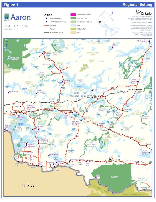
Wabigoon Lake, Wabauskang, Grassy Narrows (English River), Eagle Lake, Ojibway Nation of Saugeen and Lac Seul First Nations are all within the boundary described by the Treaty #3 (Figure 1). Aaron Provincial Park overlaps traditional lands and waters of these six First Nations.
Aaron Provincial Park is located near two Métis Nation of Ontario (MNO) asserted harvesting territories; lake of the Woods/Lac Seul and Rainy Lake/Rainy River. The closest community councils that may have an interest include Northwest (Dryden), Kenora, Sunset Country (Fort Frances), and Atikokan Métis Councils. The Aboriginal Peoples of Wabigoon are also located in the area.
Aboriginal communities use the area for hunting, trapping, fishing, gathering and travel.
1.0 Introduction
Aaron Provincial Park, established in 1958 under Ontario regulation 251/58, is a recreation class park of 117 hectares. The park is located in Zealand Township, on the TransCanada Highway (Hwy 17) east of Dryden (Figure 1). The park is located within Ecodistrict 4S 4 and the Dryden Administrative District of the Ministry of Natural Resources (MNR).
In the 1880s, the Canadian Pacific Railway was constructed adjacent to the present day location of Aaron Provincial Park and the area was opened up for settlement. The park was originally a homestead sold to John D. Aaron in 1906, which eventually reverted to the Crown. The recreational value of the site was recognized and the Department of Northern Development established it as a roadside camping park in 1935 for travellers and local residents.
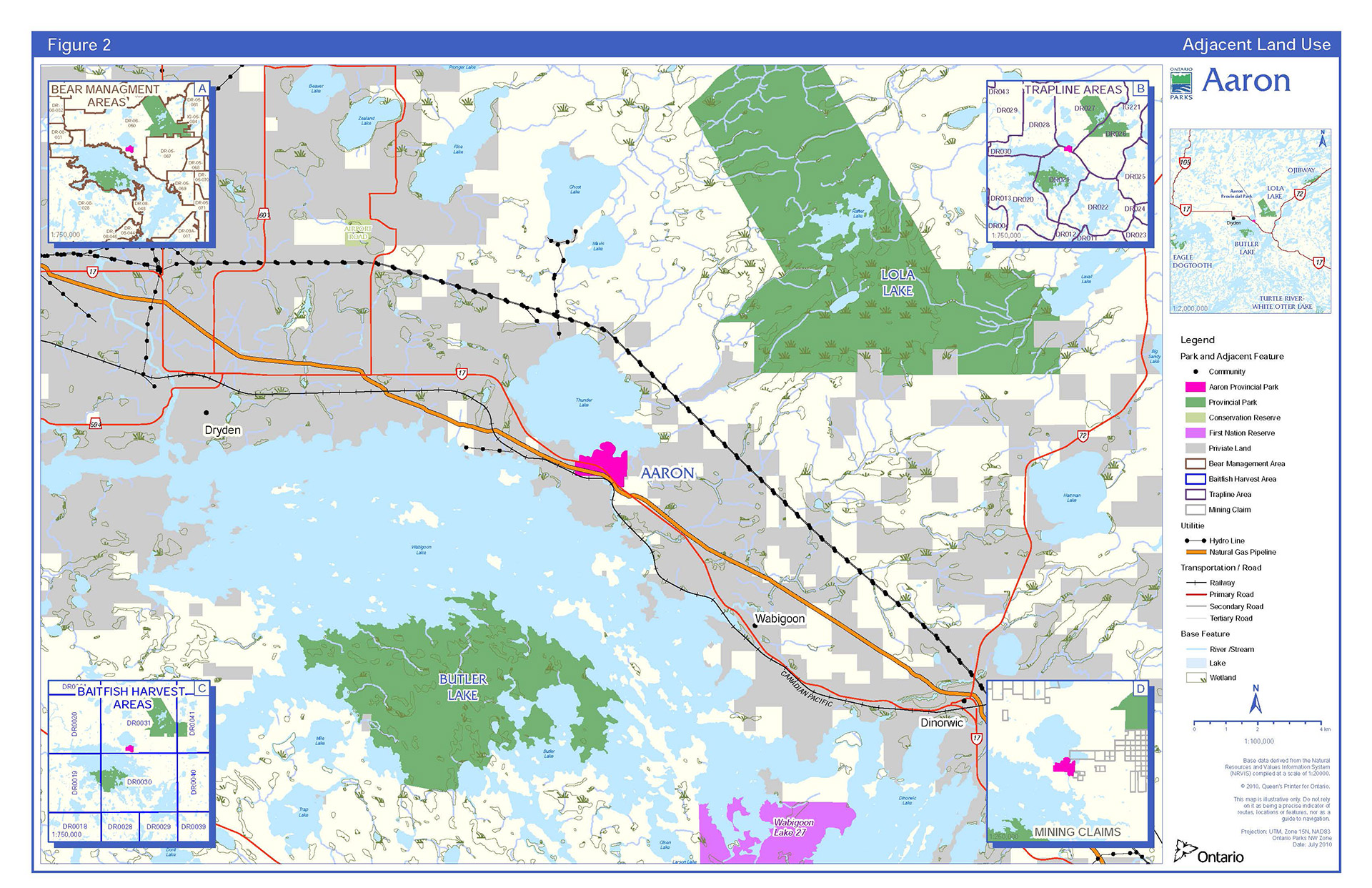
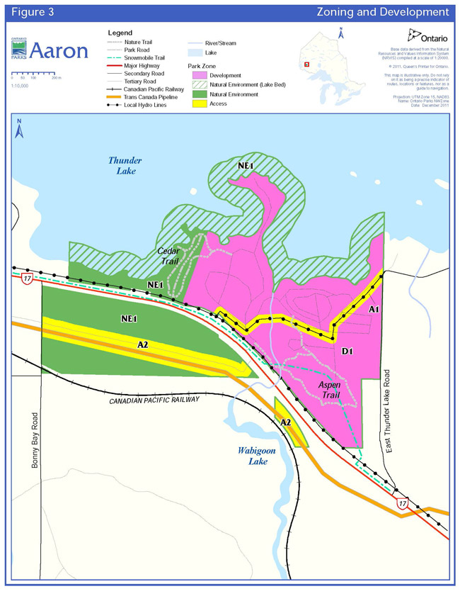
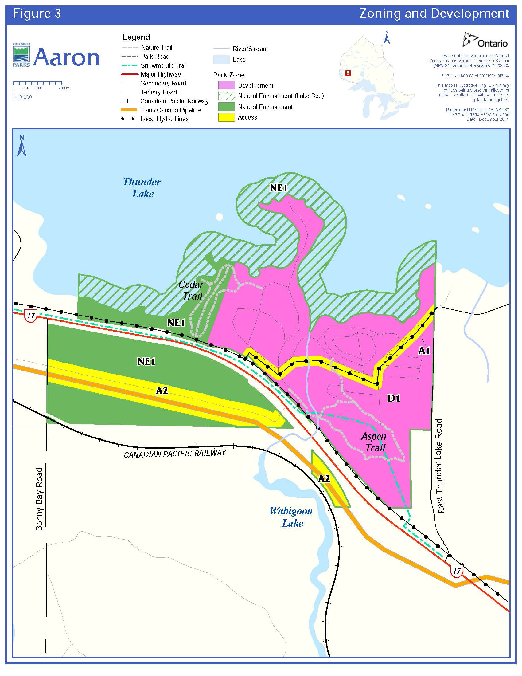
Aaron Provincial Park is comprised of three parcels of land (Park Zoning Figure 3). Highway 17 divides the park into two main parcels.
The park is on the south shore of Thunder Lake, a remnant of the ancient glaciers that covered Ontario tens of thousands of years ago. As these massive moving fields of ice shifted and melted, they left behind a huge lake called glacial Lake Agassiz. Over the years, Lake Agassiz receded, creating hundreds of smaller lakes. The park’s mixed forests of aspen, jack pine, white cedar and balsam fir, are typical of the boreal region. The forest is home to moose, white tailed deer and black bear.
Aaron Provincial Park is an operating park with 98 campsites, 39 of which have electrical hook ups. Aaron is a destination for local residents from Dryden and a stopover for travellers on Highway 17. Two sandy beaches, playground equipment and the clear, shallow waters of Thunder Lake make Aaron ideal for water based activities, such as, swimming, boating and fishing.
The approved park management plan will guide the stewardship, operation and development of Aaron over the next 20 years. Amendments may be considered as the need arises. The plan will be examined every 10 years to determine the need for further review or amendments, as described in Section 13.
The park management plan has evolved from the comments received from the public review of the terms of reference during the autumn of 2006, and the review of the preliminary park management plan during the winter of 2009/10. Aaron Provincial Park Management Plan has been developed in accordance with the Ontario Provincial Parks Planning and Management Policies (OMNR 1992), Ontario’s Living Legacy Land Use Strategy (OMNR 1999), Ontario’s Protected Areas Planning Manual and the PPCRA. In accordance with this plan, the MNR will amend affected area specific land use policies and mapping found in the Crown Land Use Policy Atlas.
Figure 1 – Regional Setting
Enlarge Figure 1 – Regional Setting
2.0 Classification
Through park classification, Ontario’s provincial parks are organized into broad categories, each of which has particular purposes and characteristics. Aaron is classified as a recreational park. Recreational class parks support a wide variety of compatible outdoor recreation opportunities in attractive natural surroundings. The target for recreational class parks is to provide residents and out of province visitors with appropriate levels of day use and facility based camping opportunities. The selection (and operation) of recreational class parks and the provision of compatible outdoor recreation opportunities is related to regional population distribution and demands.
3.0 Goal
To provide a variety of opportunities for compatible heritage appreciation, outdoor recreation, and scientific research activities in attractive surroundings, while protecting the park’s earth and life science features.
In fulfilling this goal, the park contributes to the achievement of recreation and protection objectives for the protected areas system.
4.0 Objectives
There are four objectives for Ontario’s parks: protection, recreation, heritage appreciation and scientific research.
4.1 Protection Objective
To permanently protect the park’s biodiversity and elements of the natural and cultural landscape of Ontario and to manage these to ensure that ecological integrity is maintained.
Ontario’s protected areas play an important role in representing and conserving the diversity of the province’s natural features and ecosystems. Protected areas include representative examples of life and earth science features, and cultural heritage features within ecologically or geologically defined regions. Ontario’s ecological land classification system provides the basis for the life science feature assessment, and the geological themes provide the basis for earth science assessment.
4.1.1 Life Sciences
Aaron is located on the eastern boundary of Ecodistrict 4S-4 near the southern margin of the boreal forest region. This section is described as marking a transition between the Great Lakes St. Lawrence Forest to the south and the boreal forest to the north.
Although the park is in a transitional ecodistrict, the vegetation in the park is largely characteristic of the boreal forest. The vegetation found in the park reflects the park’s transitional position between the two forest regions. Forest cover within the park consists of mature to old jack pine, on coarse, well drained sand deposits, with trembling aspen as an associate in areas where soil moisture is higher. Mixedwoods occupy sites with fine textured materials; balsam fir, jack pine, trembling aspen, white birch, and black spruce. Shoreline vegetation includes white cedar and black ash, tree species that are found near the dam on the Thunder River (Noble 1977).
The wildlife of Aaron is representative of the boreal forest region. Mammals include moose, white tailed deer, black bear and gray wolf, as well as Canada lynx, pine marten, red fox, snowshoe hare, river otter, and beaver. The birds of the park are typical of the boreal forest and include a wide variety of songbirds, raptors, shorebirds and waterfowl.
The life science features of Aaron Provincial Park are not considered to contribute to any life science themes due to the small size and high degree of disturbance of the park.
4.1.2 Earth Sciences
Aaron is located within the Canadian Shield and the terrain is generally rolling with some exposed bedrock. Aaron is underlain directly by Precambrian bedrock, consisting of highly foliated Keewatin sedimentary rocks (arkose, greywacke and quartzite) and volcanic rocks (intermediate to basic lavas) of the Wabigoon subprovince, Superior Province. The bedrock, exposed intermittently throughout the park, occurs as gentle knolls, often severely weathered or poorly exposed. Shoreline outcrops are abrupt and broken but generally low.
Surface deposits are of intermediate thickness (several metres), covering most of the park. The deposits consist predominantly of fine sand and silt with hard clay in drainage depressions and bedrock basins. The sands form a gently sloping to flat plain on which the campgrounds are built. What may be a tombolo (spit) joins the bedrock exposures on the peninsula to the main sand/silt plain. The surface deposits were produced predominantly during the Timiskaming Interstadial and represent glacial lake Agassiz and the Hartman Phase (10,000 years ago) of the retreating ice mass.
The earth science features of Aaron Provincial Park are not considered to contribute to any earth science themes due to their small size and high degree of disturbance (Kor 1977).
4.1.3 Cultural Resources
Cultural resources include any significant resource or feature of archaeological, historical, cultural, or traditional use. This may include archaeological resources, built heritage or cultural heritage landscapes (See Section 7.10). No cultural resources have been found in Aaron Provincial Park.
4.2 Recreation Objective
To provide visitors with opportunities for car camping and day use with ecologically sustainable land and water based recreation and to encourage associated economic benefits.
Aaron offers opportunities for car camping in the campground. The park provides campers and day visitors with opportunities for hiking, swimming, picnicking, fishing and boating. The majority of visitors to Aaron (64%) are drawn from travellers on the Highway 17, who use the park as a stopover en route. Local and regional residents also use the park as a camping and day use destination.
Most visitors to northwest zone parks are from northwestern Ontario (51.5%), from other provinces (western Canada) (36.6%) and from the United States (11.9%), specifically Minnesota, Wisconsin and Michigan (Ontario Parks 2006). This is in contrast to the origins of park users on a province wide basis where the majority of park visitors came from southwestern Ontario (20.6%), central Ontario (37.4%), Metro Toronto (11.3%) and eastern Ontario (16.4%), 5.4% originated in other provinces and 3.6% of visitors came from the United States (Ontario Parks 2006).
The 2005 Park User Survey indicates that, in general, most visitors to Aaron engage in resting/relaxing (94%), followed by swimming/wading (81%), trail hiking (62%), viewing/photographing nature (47%), picnicking (44%), and visiting viewpoints/lookouts (41%) (Ontario Parks 2006).
In 2007, the average length of stay for campers was 1.6 nights. The average party size was three and the July/August occupancy rate averaged 55% (Ontario Parks 2008). Day users (approximately 20% of users) are local residents, mostly from the Dryden area (Ontario Parks 2008). Some of the day-users visiting Aaron are tourists travelling the TransCanada Highway, who visit as one of several destinations, or as an unplanned stopover en route. Day users visiting Aaron are members of family groups participating in picnicking, relaxing, walking on the beach, swimming or wading.
Winter day use for Aaron is moderate; with cross country skiing on park trails and some use of motorized snow vehicles. Winter day-use is local in origin.
4.3 Heritage Appreciation
To provide opportunities for residents of Ontario and visitors, to increase their knowledge and appreciation of Ontario’s natural and cultural heritage.
Aaron is designated as a self use activity park. Self use parks provide comprehensive information / orientation services as well as self use facilities such as trails. Ontario Parks’ staff maintain these facilities. Additional public programs are offered at the discretion of the park superintendent.
Based on the region’s natural features and history, interpretive themes have been identified for Aaron Provincial Park. These themes include:
- ecology of the Canadian Shield and the boreal forest
- settlement and tourism history of the park area
4.4 Scientific Research Objective
To facilitate scientific research and to provide benchmarks to support monitoring of ecological change on the broader landscape.
Ontario Parks plays an important role in the provision of places to undertake research activities to: provide a better understanding of park environments, contribute to appropriate park management practices and actions, and provide baseline ecological information that can be used to support ecological monitoring on the broader landscape.
For example, in many parks in the northwest zone, staff establishes Ontario Parks Inventory and Monitoring plots (OPIAM), although none have been established in Aaron to date. Baseline information is collected on vegetation, soil, and ecosite types, as well as incidental floral and faunal observations.
5.0 Boundary
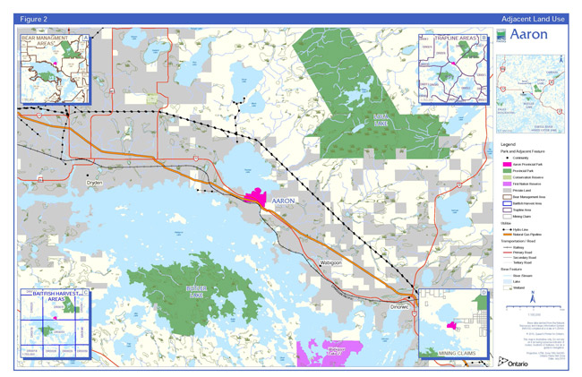
Aaron Provincial Park, established in 1958 under Ontario regulation 251/58, is a recreation class park of 117 hectares. The park consists entirely of Crown land (Figure 2).
The following is a brief description of land tenure in the park and surrounding area:
- Aaron Provincial Park is divided by the TransCanada Highway (Hwy 17)
- The park boundary extends approximately 91 metres into Thunder Lake
- TransCanada has natural gas pipeline under Crown easement through Aaron on the south side of Highway 17
- Hydro One has an electricity transmission corridor under the authority of a Land Use Permit (LUP #9999-11, file #RR-LM-6) through the park
- Canadian Pacific Railway has a patent right of way that divides the southwest corner of the park.
- Lands along the shores of Thunder Lake, adjacent to the park, are used for private residences, seasonal residences and commercial tourism
Ontario Parks is committed to an ecosystem approach to park planning and management. An ecosystem approach allows park management to consider the relationship between the park and the surrounding environment. Park managers may consider potential impacts on park values and features from activities occurring on adjacent lands, and potential impacts from park activities on land uses in adjacent areas.
Within the park boundary, the protection of park values and features will be achieved through appropriate zoning, management of land use and activities, education, and monitoring of ecological impacts.
Ontario Parks will support in principle the acquisition of property for addition to Aaron Provincial Park, if the acquisition will enhance the values of the park. Acquisition or securement will be subject to funding and willingness of the owners to sell or lease their properties or enter into a conservation easement.
If any lands within, nearby or adjacent to the park become available for acquisition, they will be evaluated with regard to their contribution to park objectives and available funding.
6.0 Zoning
Lands within Aaron Provincial Park are zoned in accordance with their environmental and cultural features and values, and their sensitivity to development. Aaron will be managed with three types of zones: natural environment, access and development, based on the Ontario Provincial Parks: Planning and Management Policies (Figure 3). The zones consider the sensitivity of the natural and cultural values, the permissible degree of development, recreational uses, and management practices within the park.
Figure 2 – Adjacent Land Use
Enlarge Figure 2 – Adjacent Land Use
6.1 Development Zone
Development zones contain areas of the park geared towards the support of intensive day use and car camping activities. They constitute a relatively small portion of most parks. Development may include roads, visitor control structures, beaches, picnic areas, car campgrounds, commercial service facilities, maintenance facilities, park office and orientation, interpretive, educational, research and management facilities (Figure 3).
D1: Campground and Day–Use, 51 Hectares
User activity and facility development is concentrated in D1 (campground and day-use development zone) which is located in the central portion of the park. Existing development in D1 consists of campgrounds, day use areas, the Aspen Hiking Trail and the park administrative complex.
6.2 Access Zones
Access zones serve as staging areas for people, a means of both providing and regulating use in areas of a park geared towards extensive recreation. Generally development is limited to roads, visitor control structures and group campgrounds. Provisions may be made for limited orientation, interpretive or educational facilities for self use, rather than through structured personal service. Limited facilities for research and park management may also be present (Figure 3).
A1: Hydro Corridor, 3 Hectares
A1 includes the hydro corridor that runs through the park campground from the hydro corridor on the north side of Highway 17 and includes a 10 metre wide corridor, measured from the midpoint of the hydro right of way.
A2: Pipeline Corridor, 10 Hectares
A2 includes a 30 metre wide corridor that includes the pipeline and access road that divides the southern parcels of the park.
6.3 Natural Environment Zone
Natural environment zones include natural landscapes which permit the minimum level of development required to support low intensity recreational activities. This minimum level of development is generally limited to back country campsites, portages, necessary signage and minimal interpretive facilities (Figure 3).
NE1: Natural Environment, 53 hectares
The NE1 zone constitutes the balance (45%) of the park area that is not included in the development zone or the access zones, including where the park extends into Thunder Lake. The Eastern White Cedar Trail is located in this zone.
7.0 Resource Stewardship Policies
The stewardship of Aaron Provincial Park’s natural and cultural resources will conform to the policies identified for recreational class parks in Ontario Provincial Parks: Planning and Management Policies (OMNR 1992) and Ontario’s Living Legacy Land Use Strategy (OMNR 1999). Additional policy direction is provided in the following section. Planning and management is intended to contribute to the maintenance or enhancement of the ecological integrity of the park, a guiding principle of the Act.
Figure 3 – Zoning and Development
Enlarge Figure 3 – Zoning and Development
Resource stewardship initiatives may be accomplished through partnerships and sponsorships. All resource stewardship activities will be undertaken in accordance with requirements under the PPCRA, Environmental Assessment Act (EAA), A Class Environmental Assessment for Provincial Parks and Conservation Reserves (Class EA PPCR), and any other applicable legislation and policies.
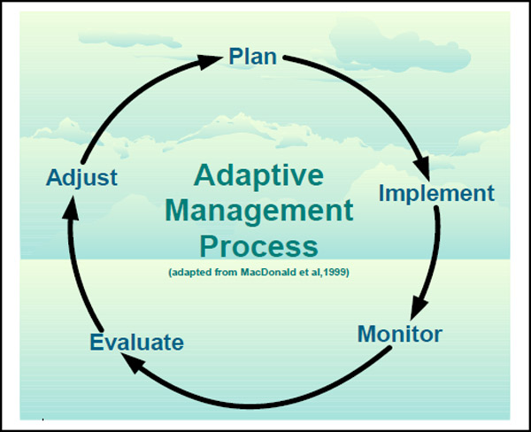
An adaptive management approach (Figure 4) will be applied to resource management activities within Aaron Provincial Park. Adaptive management allows management strategies to be changed, as required, in response to monitoring and analysis of the results of past actions and experiences.
Figure 4 – Adaptive Management Process
7.1 Aboriginal Uses of Natural Resources
Wabigoon Lake, Wabauskang, Grassy Narrows (English River), Eagle Lake, Ojibway Nation of Saugeen, and Lac Seul These communities are all within the boundary described by Treaty #3. Aaron Provincial Park overlaps the traditional lands and waters of these six First Nations, which use the area for hunting, trapping, fishing, wild rice harvesting, other gathering, and travel.
Aaron Provincial Park overlaps two Métis Nation of Ontario (MNO) asserted harvesting territories; Lake of the Woods/Lac Seul and Rainy Lake/Rainy River. The closest community councils that may have an interest include Northwest (Dryden), Kenora, Sunset Country (Fort Frances), Kenora and Atikokan Métis Councils. The Aboriginal Peoples of Wabigoon are also located in the area.
This plan recognizes the inherent rights of the First Nations and Aboriginal communities and acknowledges that their traditional activities in Aaron Provincial Park will not be affected by park policies, provided that safety and conservation concerns are not compromised.
7.2 Industrial / Commercial Uses
Figure 4: Adaptive Management Process
The following uses are not permitted in the park:
- Commercial timber harvest
- Prospecting, staking, mining claims, developing mineral interests, working mines
- Extraction of sand, gravel, topsoil or peat
- Generation of electricity (except for in-park use)
- Other industrial uses
7.3 Land Management
Management of the park’s land base will be directed toward maintaining the natural landscape. The land uses/developments adjacent to the park (Section 5.0) will be considered in the management of the park.
No land disposition for private use is permitted.
7.4 Water Management
Water management in the park will maintain water quality and quantity for fisheries habitat and recreational purposes. The park water system is supplied by surface water. Water quality will be monitored on a regular basis in the development zone, in accordance with current Ontario Safe Drinking Water Regulations and the Ontario Beach Management Protocol.
Surrounding land use does not currently have a direct impact on recreational water quality.
7.5 Forest Fire Management
Aaron Provincial Park is located in the Boreal Forest Fire Management Zone under the Forest Fire Management Strategy for Ontario (OMNR 2004). The MNR recognizes fire as an essential ecosystem process, fundamental to restoring and maintaining the ecological integrity of protected areas in the boreal forest region.
The fire management objectives for Aaron Provincial Park are to prevent loss of life, personal injury and socio economic disruption, and to minimize loss or damage to park property and infrastructure. Given the capital investment in facilities within the park, and the amount of adjacent development (e.g. the City of Dryden, Highway 17, the CP rail line, the TransCanada Pipeline, hydro transmission corridors, private residences on Thunder Lake), fires in all zones will receive full response and sustained action until extinguished.
Prescribed burning is the deliberate, planned and knowledgeable application of fire by authorized personnel, to a specific land area, to accomplish pre determined objectives. Prescribed burning to achieve ecological or hazard reduction objectives may be considered. Plans for any prescribed burning will be developed in accordance with the MNR policy.
7.6 Species at Risk
There are no known species at risk in the park.
If found in the park, species at risk and their habitat will be protected consistent with the Endangered Species Act, 2007, and its regulations.
7.7 Vegetation
Management of vegetation within the park will be directed toward maintaining the natural succession of vegetation.
Infestations of forest insects and diseases will be monitored and assessed. Non-native species may be controlled in all zones, and native species may be controlled only in the development and access zones, subject to applicable legislation. If control measures are undertaken, they will be applied to minimize effects on the park ecosystems, or for human health and safety purposes in access and development zones.
The removal of hazard trees will be permitted in all zones where safety is a concern (e.g., trails, campgrounds). Areas that are adversely affected by use will be rehabilitated using plant species native to the park whenever possible. Landscaping will be permitted in the development zones; effort will be made to incorporate natural features and exclusive use of native species to restore vegetation.
Brushing along primary and secondary roads as well as along hiking trails will be permitted to improve sight lines and/or traffic flow.
Herbicide applications will be discouraged. Mechanized or hand tending of the Hydro One corridor and the TransCanada pipeline corridor will be encouraged.
Any development that requires the removal of vegetation will be supported by a vegetation inventory, in accordance with approved site plans.
7.8 Wildlife
Hunting is not permitted in Aaron Provincial Park.
Wildlife population(s), mortally wounded animals or individual animals may be controlled when essential human health or safety risks arise, or when the values for which the park has been established are in jeopardy. Control must be consistent with existing provincial policy direction for wildlife species. Where control is necessary, techniques that have minimal effects on other components of the park’s environment will be used. Appropriate methods of population control for wildlife under the mandate of the Fish and Wildlife Conservation Act, 1997 (FWCA), may be undertaken directly by Ontario Parks, or through partnership with Ontario Parks.
7.9 Fisheries
Sport fishing occurs on Thunder Lake, adjacent to the park. All fishing activities are subject to provincial and federal fisheries regulations (e.g., FWCA and the Fisheries Act (Canada)) as set out in the Ontario Recreational Fishing Regulations Summary.
Thunder Lake is a popular fishing lake, supporting lake trout, walleye and northern pike. Fishing for alternative species will be encouraged, as specified in the Dryden District Fisheries Management Plan (OMNR 1987).
7.10 Cultural Heritage Resource Management
The management of cultural heritage resources in Aaron Provincial Park will be directed towards protection, heritage appreciation and research. Cultural heritage resources that may be impacted by any park projects or activities will be identified and managed (i.e. protected, maintained, used and disposed of) in accordance with the Standards and Guidelines for Conservation of Provincial Heritage Properties (Ontario Heritage Act, Part III.1). Staff will also consult MNR’s Technical Guideline for Cultural Heritage Resources.
No known cultural heritage or archaeological features exist within the park boundaries.
In the event of a discovery of an archaeological site, Ontario Parks will work with the Ontario Ministry of Tourism to identify and assess the significance of the site.
Ontario Parks will involve nearby Aboriginal communities on matters pertaining to Aboriginal history, any sites found within the park associated with Aboriginal culture, interpretation of Aboriginal history, and appropriate use of cultural artefacts. The precise location of any found Aboriginal cultural sites, including burial sites, will not be disclosed to the public.
The removal of artefacts or destruction of historical features is illegal and is prohibited by the PPCRA.
7.11 Research
Ontario Parks encourages scientific research by qualified individuals who can contribute to the knowledge of natural and cultural history and to environmental management in provincial parks. All research at Aaron Provincial Park will be conducted by, or authorized by, Ontario Parks. Research projects will be administered through the park and require a research permit. Research must also meet all requirements under applicable provincial and federal legislation. Approved research and monitoring activities must be consistent with Ontario Parks’ Research and Information Strategy (Ontario Parks 1997). Temporary facilities in support of approved research and monitoring activities may be considered.
Approved research activities and facilities will be compatible with protection values and/or recreational uses in the park, and will be subject to development and stewardship policies associated with the park’s classification, unless special permission is given. Sites altered by research activities will be rehabilitated as closely as possible to their previous condition.
7.12 Inventory and Monitoring
Planning and management decisions are intended to contribute to the maintenance or enhancement of the ecological integrity of the park. Considerations will be given to allow ecological, social and economic inventory and monitoring, to assess affects of use and management. Ontario Parks will ensure that decisions are made with the best available information. Where this information is lacking, Ontario Parks may conduct inventories and monitoring to gather data. Such efforts will be undertaken based on established methodologies and best practices. This will foster an adaptive management approach to protected areas management. The following are broad approaches to identifying inventory and monitoring needs: management actions identified in this management plan, public input, routine park maintenance activities, staff knowledge and experiences, and environmental scans.
8.0 Operations Policies
A park operations plan will be prepared to provide park staff with the necessary direction required to operate the park on a day to day basis. In addition to addressing the operations policies, the plan will include such topics as budget, staffing, maintenance schedules, enforcement, and emergency services. The provisions of the plan will be consistent with the approved Ontario Provincial Parks Minimum Operating Standards, and will be reviewed annually and updated as required.
8.1 Natural Heritage Education
As outlined in the Strategic Plan for Natural Heritage Education in Ontario Parks 2005 – 2010 (Ontario Parks 2005), the goal of the Natural Heritage Education (NHE) program is to develop visitor awareness and appreciation of Ontario Parks’ natural and cultural heritage, fostering a commitment to its protection for all generations. Opportunities to do so will be educational and recreational, formal and informal, and accessible to all people.
The objectives of the NHE program are to provide basic information in all parks, interpretation of Ontario’s natural and cultural heritage in provincial parks, and outdoor recreation in representative landscapes in Ontario. There are three levels of NHE service in the Ontario Park’s system: self use, seasonal activity and major activity. Aaron offers a self use level of programming. Self use facility parks provide comprehensive information / orientation services as well as self use services, such as trails. Park staff maintains these facilities.
A NHE plan and an annual NHE operating plan will be prepared for the park. Direction will be taken from provincial policy, the Northwest Zone Natural Heritage Education Plan, and the park management plan. The Aaron NHE plan will be reviewed and updated as required. The scope and intent of all NHE activities will be carefully defined to ensure their compatibility with park features.
8.1.1 Information
The public information program will provide visitors with information about the park, its resources, environment and facilities, the park system and local attractions. This information emphasizes the visitor’s role in maintaining the natural environment of the park, appropriate behaviour in the park, safety in the outdoors and dealing with problem wildlife. Park literature will also advise visitors about commercial services and attractions in the local area and other Ontario Parks.
8.1.2 Park Interpretation
Self use interpretive facilities will provide park visitors with a greater appreciation for and understanding of the natural features of Aaron Provincial Park. Printed material, self use facilities and informal personal contact will be the primary means of interpretation. Formal NHE programs are not typically provided in self use parks. Additional public programs and special events are offered at the discretion of the park superintendent. Aaron has a park amphitheatre which is used for special events.
Aaron’s primary interpretive themes are:
- ecology of the Canadian Shield and the boreal forest
- settlement and tourism history of the Aaron park area
8.1.3 Outdoor Recreation
Park visitors will be informed about the opportunities for recreation offered in the park and in the local area. Visitors will be encouraged to use safe boating practices, through the park’s information program.
Outdoor recreation skills programs that may be offered will be compatible with maintaining the ecological integrity of the park and the park’s interpretive themes, and may include hiking, cross country skiing, snowshoeing, canoeing, camping and orienteering.
8.2 Recreation Management
Recreation management provides a variety of recreational opportunities while aspiring to minimize negative environmental impacts. Recreational activities that are incompatible with the park goal or with specific zones, or the maintenance or restoration of ecological integrity, are prohibited or restricted. Prevention and control of such activities will be achieved through enforcement, facility design, compliance, and education of park visitors concerning appropriate activities in the park in general and within specific zones.
8.2.1 Day Use Area
Aaron Provincial Park is a destination for local residents from Dryden and a stopover for travellers on the TransCanada Highway. Two sandy beaches and playgrounds appeal to day users. The clear, shallow waters of Thunder Lake make the park ideal for swimming, boating and fishing.
Day users participate in picnicking, relaxing, walking on the beach, swimming or wading. The park’s day use facilities are adjacent to Thunder Lake. The sites include picnic tables, a picnic shelter, fireplace grills, water, vault privies and playground equipment. The beach areas offer swimming and beach play. A boat launch is located at the northernmost day use area.
8.2.2 Campgrounds
Aaron Provincial Park has 98 campsites, 39 of which are provided with electrical hook ups. Approximately one quarter of the sites are pull through, for trailers and recreational vehicles. There is one group camping area, which can accommodate up to 100 people. Refer to Section 10.1 regarding expansion.
Campground amenities include vault privies, a comfort station with shower and laundry facilities, trailer service facilities, water outlets, garbage disposal, recycling depots and firewood sales.
All campgrounds and campsites will be monitored to ensure their continued ecological and economic viability. This will include necessary improvements to bring them to Ontario Parks’ operating standards.
Aaron offers a designated number of seasonal leases for sites. These leases are awarded annually through a draw. This practice will be reviewed annually to ensure its continued feasibility to the operating partner. Leased sites will be rotated to minimize cumulative impacts to the sites.
8.2.3 Services for Visitors
Aaron Provincial Park is located in the Sunset Country Travel Area, which spans northwestern Ontario, from Fort Frances to Upsala and north to Red Lake and Pickle Lake.
The development of private commercial tourism operations in Ontario Parks, such as food and beverage services, recreation equipment rental/sales and retail sales, will be determined through business planning, in conjunction with the zone and park marketing plan.
8.2.4 Trails
There are two interpretive/hiking trails in the park: the Aspen Trail (development zone, 1.9 kilometres) and the Eastern White Cedar Trail (natural environment zone, 1.2 kilometres). The Aspen Trail winds through aspen forests, old blow down and granite outcrops. The Eastern White Cedar Trail meanders through old growth cedar stands, along the shores of Thunder Lake and through small wetlands. Hiking trails serve as ski trails in winter; they are not mechanically groomed.
8.2.5 Mechanized Travel
Recreational motorized vehicle use, including all terrain vehicles (ATVs) and snowmobiles, is prohibited on park hiking/interpretive trails. A local authorized trail that is utilized by snowmobiles runs through the park on specific roads/trails. This trail avoids a dangerous bridge crossing on Hwy 17. The trail is closed to ATVs in summer months (i.e. June, July, and August).
Mountain bikes are permitted on campground roads only; they are not permitted on the park hiking/interpretive trails.
8.3 Partnerships
Ontario Parks has been operating Aaron through a partnership agreement with the City of Dryden since 1997. Ontario Parks will continue to work with the City of Dryden to provide campground operations, subject to the regular review and renewal of the partnership agreement.
9.0 Marketing and Communications
9.1 Marketing
A marketing plan may be developed for Aaron Provincial Park, in accordance with the Ontario Parks Marketing Plan, the Northwest Zone Marketing Plan and Ontario Parks policy. It will be reviewed and revised as required. Marketing activities will be consistent with the zone and provincial marketing plan.
9.2 Communications
Aaron uses the standard public information program (e.g. Ontario Parks’ guide, park tabloid, park maps and the Ontario Parks’ website). This public information program will be continued.
10.0 Development Policies
All development undertaken by Ontario Parks, or by partners on its behalf, will comply with Class EA PPCR, and will be carried out in accordance with approved site and development plans that meet development standards for provincial parks.
Areas proposed for significant development will require prior assessment for significant cultural heritage features and natural values such as species at risk to ensure these values are identified and protected at the site.
10.1 Campgrounds / Campsites
The campground at Aaron may be expanded by as many as 20 sites, with associated infrastructure, if the demand for such facilities becomes evident.
10.2 Roads
The construction of new roads, bridges and utility corridors for park purposes will be directed by approved secondary plans. Such projects will be permitted in the development zones only. Construction will be closely monitored.
10.3 Day Use Area
Ontario Parks will continue to monitor the quality of the day use area. Development in the day use area will focus on:
- Re design and re development to improve quality and operational effectiveness
- A limited amount of new development to provide additional day use opportunities (i.e., picnic shelters)
Where user conflicts or operational inefficiencies exist, separation of day use and camper activity may be undertaken.
10.4 Trails
The construction of any new trails in the natural environment and development zones will be subject to approved site plans.
10.5 Maintenance and Administrative Areas
The park warehouse, office and gatehouse will be upgraded / replaced as required, subject to available resources.
11.0 Implementation Priorities
Park development, operations and resource stewardship will be contingent upon the availability of funding and unforeseeable changes in priorities or policy. Implementation of the management plan and operation of the park will meet the requirements of the EAA, EBR, PPCRA, ESA, 2007 and other pertinent legislation.
All aspects of park management, development and operation will be undertaken in accordance with the requirements of Class EA PPCR.
Park development proposals will be phased in as follows:
11.1 Stage One
- Replacement and/or upgrading of park facilities as required
- Preparation of a NHE plan
- Preparation of a park marketing plan/strategy
- Annual review of the operating plan, the business plan
12.0 Summary of Aboriginal Involvement and Public and Stakeholder Involvement
Involvement with Aboriginal communities and with the public and stakeholders was an important part of the Aaron park management planning process. To date, public involvement in the development of the park management plan has included several opportunities:
- Phase 1 Terms of reference and invitation to participate
- Phase 2 Preliminary park management plan
- Phase 3 Approved park management plan
Phase 1 – Invitation to participate; terms of reference October 2, 2006 – November 16, 2006
The invitation to participate and opportunity to review the approved terms of reference stages included newspaper advertisements, distribution of a notification letter to the mandatory contact list and to known stakeholders, an EBR Environmental Registry (ER) proposal notice, distribution of a notification letter to park, zone and district offices, and the Ministry of Natural Resources Information Centre in Peterborough.
Three written comments were received at the northwest zone office from October 2 to November 16:
- The Union of Ontario Indians commented on consultation with First Nations.
- The Ontario Archaeological Society commented regarding archaeological resources.
- The Ministry of Transportation commented regarding highway right of-way requirements.
Phase 2 – Preliminary Management Plan December 10th 2009 until January 25th, 2010
This phase included newspaper advertisements, and distribution of a notification letter regarding the release of the preliminary park management plan to the mandatory contact list and to known stakeholders, as well as an update to the ER notice listed above. The document was also available on the Ontario Parks’ website.
Five written comments were received from individuals and groups including local park users, Ontario Power Generation, and the Métis Nation of Ontario. Concerns and suggestions included minor corrections to maps and tenure information, expansion of the NHE program, improvements to park facilities (e.g. comfort stations, playground, amphitheatre) and the development of new facilities (e.g. day use area pavilion).
Phase 3 – Approved park management plan September 5 October 17th, 2012
In Phase 3, a policy decision notice associated with the approved park management plan was posted on the ER and a paid advertisement was inserted in local and regional newspapers. A notification letter was mailed to local First Nations and Aboriginal communities, local residents, interest groups and others in September 2012. This allowed interested participants a final 45–day opportunity to determine if their concerns had been adequately considered and addressed, and to initiate an appeal of the plan contents where appropriate.
Ontario Parks will retain on file reference copies of the terms of reference, preliminary management plan and the approved park management plan.
13.0 Plan Amendment and Review
The park management plan can be reviewed or amended to address changing issues or conditions. At ten year intervals, this plan will be examined for the need for a review or amendment.
A review may involve a reassessment of all or part of the plan, including classification, zoning, goal, objectives and all resource management, operations and development policies.
An amendment can be considered to address specific issues or needs.
14.0 References
Crins, W. J. 2002. Ecozones, ecoregions and ecodistricts of Ontario. (OMNR) Prepared for the ELC Working Group.
Crins, W. J., and Uhlig, P.W.C. 2000. Ecoregions of Ontario: Modifications to Angus Hills’ Site Regions and Districts: Revisions and Rationale (Ontario Ministry of Natural Resources).
Kor, P. 1977. Earth Science Inventory Checklist Aaron Provincial Park.
Noble, T. 1977. Ontario Nature Reserves Program – Life Science Inventory Check sheet Aaron Provincial Park.
[OMNR] Ontario Ministry of Natural Resources. 1987. Dryden District Fisheries Management Plan 1987 2000 Draft.
[OMNR] Ontario Ministry of Natural Resources. 1992. Ontario Provincial Parks: Planning and Management Polices. Ontario.
[OMNR] Ontario Ministry of Natural Resources. 1999. Ontario’s Living Legacy Land Use Strategy. Queen’s Printer for Ontario. Toronto.
[OMNR] Ontario Ministry of Natural Resources. 2004. Forest Fire Management Strategy for Ontario.
[OMNR] Ontario Ministry of Natural Resources. 2005a. Our Sustainable Future Ministry of Natural Resources Strategic Directions. Natural Resources Information Centre, Peterborough.
[OMNR] Ontario Ministry of Natural Resources. 2005b. Protecting What Sustains Us: Ontario’s Biodiversity Strategy. Queen’s Printer for Ontario, Peterborough.
Ontario Parks. 1992. Ontario Provincial Parks Minimum Operating Standards.
Ontario Parks. 1997. Ontario Parks’ Research and Information Strategy. Ontario Parks. 2005. Strategic Plan for Natural Heritage Education in Ontario Parks 2005 2010
Ontario Parks. 2006. Park User Survey Camper Statistical Summary–2005. Queen’s Printer for Ontario.
Ontario Parks. 2007. Park Statistics 2006. Queen’s Printer for Ontario.
Ontario Parks. 2008. Park Statistics 2007. Queen’s Printer for Ontario.
UCMP 2003 Glossary of Natural History Terms Volume 5 Ecological terms.
Van Wagoner, D. 2000. Tourism: trends and opportunities in the North of Superior Region. Ministry of Northern Development and Mines.
Zoltai, S.C. 1961. Glacial history of part of northwestern Ontario. Proc. Geol. Assoc. Canada, vol. 13.
Appendix I – Scientific Names of Plants and Animals Referenced in the Document
Plants:
aspen (Populus tremuloides)
balsam fir (Abies balsamea)
black spruce (Picea mariana)
Canada yew (Taxus canadensis)
jack pine (Pinus banksiana)
nodding trillium (trillium cernuum)
red pine (Pinus resinosa)
white birch (Betula papyrifera)
white spruce (Picea glauca)
wild ginger (Asarum canadense)
Mammals:
beaver (Castor canadensis)
black bear (Ursus americanus)
lynx (Lynx canadensis)
moose (Alces alces)
American marten (Martes americana)
red fox (Vulpes vulpes)
river otter (Lutra canadensis)
snowshoe hare (Lepus americanus)
timber wolf (Canis lupus)
white tailed deer (Odocoileus virginianus)
Fish:
lake whitefish (Coregonus clupeaformis)
northern pike (Esox lucius)
smallmouth bass (Micropterus dolomieu)
walleye (Stizostedion vitreum vitreum)