Adam Creek Provincial Park Management Statement
This document provides direction on the management of Adam Creek Provincial Park.
ISBN 0-7729-0175-9
MNR 3290
Interim Management Statement
Kapuskasing District
April 1985
© Government of Ontario
Additional copies of this publication are available from the Ministry of Natural Resources, Kapuskasing District Office, 6-8-10 Government Rd., Kapuskasing, Ontario, P5N 2W4 - Telephone (705) 335-6191.
March, 1985
Regional Director’s approval statement
I am pleased to approve this Interim Management Statement for Adam Creek Provincial Park.
This Statement will provide direction for the management of Adam Creek Provincial Park until a Park Management Plan is completed. It will also set the general direction for the preparation of the more detailed management policies that the Management Plan will contain.
Signed by
R.A. Riley
Regional Director
Northern Region
Background
| Name: | Adam Creek (Formerly Sanborn Twp.) |
|---|---|
| Proposed class: | Nature Reserve |
| M.N.R. District: | Kapuskasing |
| M.N.R. Region: | Northern |
| Area (ha.): | 20 ha. |
| Site region: | |
| Site district: | |
| Date in regulation: |
Life science target
| Site type/landscape unit | species/ communities |
|---|---|
Earth science target
| Geological theme | Feature |
|---|---|
| Quaternary - Wisconsinan |
|
Cultural resource target
| Theme | Theme segment |
|---|---|
Recreation opportunities target
| Day use | Car camping | Wilderness back country |
|---|---|---|
Inventories
| Level type | Earth science | Life science | Cultural | Recreational |
|---|---|---|---|---|
| Reconnaissance completed | Yes | No | No | No |
| Detailed completed | Yes | No | No | No |
| Required | No | No | No | No |
Potential resource use conflict
Ontario Hydro Flooding Reserve
Material appended
DLUG extract
Checksheet
Other: Background information sheet
Management statement
1.0 Issues
There are no relevant management issues for this park.
2.0 Resource management guidelines
2.1 Mineral resource management
| Analysis | Guidelines | Recommendation |
|---|---|---|
| The nature reserve status of the park protects it from any form of degrading land use/ activity including such forms of surface exploration/mining as open pit mining. | Geological investigation may be authorized by the district manager provided that such activity enhances knowledge/understanding of the geological features, and that the results of such work are made available to M.N.R. Mineral exploration/extraction will not be permitted within the park. | That the guidelines be implemented with the approval of the plan and following appropriate changes to regulation. |
2.2 Wildlife management
| Analysis | Guidelines | Recommendation |
|---|---|---|
| The park falls within Trapline KA-78. | As hunting and trapping pose no threat to site values, these activities will be permitted. | That the guidelines be implemented with the approval of the plan and following appropriate changes to regulations under The Game and Fish Act. |
2.3 Vegetation management
| Analysis | Guidelines | Recommendation |
|---|---|---|
| The park contains no known significant vegetation sites. | Silvicultural which enhances the park’s geological features will be permitted. | That the guidelines be implemented with the approval of the plan. |
2.4 Land management
| Analysis | Guidelines | Recommendation |
|---|---|---|
| There is no leased or private land within the park. However, Ontario Hydro has flooding rights to valley as a high water diversion for its dams on the Mattagami River. | No disposition of land will be permitted. | This guideline is already in effect. |
3.0 Client services management guidelines
3.1 Information:
Basic information about Adam Creek Provincial Park will be produced for geologists and students. Specifically, a small leaflet providing information about access, the park’s significance, references, and so forth, using photos, geological maps, and text should be adequate.
3.2 Education:
Prospective visitors should be warned of the resource’s vulnerability to damage from collectors; for example in any publication which is produced for the park.
3.3 Development:
At present, the site is undeveloped and access is restricted to the use of watercraft. This situation facilitates protection of the site from human impact, and will be maintained.
4.0 Research
The Ontario Provincial Parks Planning and Management Policies describes scientific research policy in nature reserves as follows (NR-IV-10).
Scientific research by qualified individuals, which contributes to knowledge of natural …. history and to environmental management, will be encouraged in Nature Reserves.
All research programmes will require the approval of the Ministry of Natural Resources and must also meet all requirements under applicable provincial and federal legislation. The Ministry may approve the removal of …. geological samples …. by qualified researchers …. Approved research activities and facilities will be compatible with protection values …. in individual Reserves, and will be subject to development and management policies for Nature Reserves unless special permission is given. Sites altered research activities will be rehabilitated as closely to their previous condition as possible.
Figure 1. Map
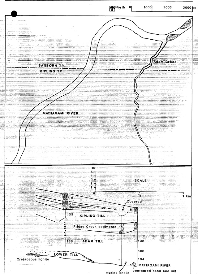
Figure 2. Regional settings map
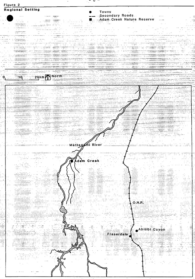
Enlarge Figure 2. Regional settings map
Adam Creek Nature Reserve
(to be replaced by official Survey Plan)
General
In the District of Cochrane, in the Township of Sanborn, located in the Kapuskasing Administrative District.
Metes & bounds
Commencing at a point measured 2.57 kilometres west 42 north from the southeast corner of Sanborn Township, at the confluence of the Mattagami River and Adam Creek; thence in a generally southwesterly direction at a distance of 100 metres from the low water mark on both sides of Adam Creek for 2 kilometres upstream: being an area of 20 hectares more or less.
Appendix I: Natural resources background information
Frey (1980) appraises the park’s earth science features as being of national significance based on the following rationale.
This section of the Adam Creek shoreline is the most accessible part of the internationally recognized standard reference (stratigraphic type section) of the Early to Middle Wisconsinan Adam Till and the Late Wisconsinan Kipling Till (INQUA, 1977, p.21, 22, 30, 31). The downstream end of the exposures on the Missinaibi River of this as yet formally undefined deposit (a type section has not been selected).
In composite the site-displays a complete record of the multiple glacial and non-glacial deposits of northern Ontario since the last interglacial events recorded in the Missinaibi Formation. In addition, a small outcrop of lignite of the Lower Cretaceous Mattagami Formation occurs at the upstream end of the site.
Appendix II
6. Sanborn site
-
Description
The nature reserve candidate m Sanborn Township includes 50 hectares along Adam Creek and protects a geological feature of national significance. This section of shoreline is the most accessible part of the internationally recognized standard reference of the Early to Middle Wisconsinan Adam Till and the Late Wisconsinan Kipling Till. The downstream end of the exposures also contain a regionally representative stratigraphic section of the non-glacial Friday Creek sediments, complimenting extensive exposures on the Missinaibi River. In composite the site displays a complete record of the multiple glacial and non-glacial deposits of Northern Ontario since the last interglacial events recorded in the Missinaibi Formation.
This candidate is currently contained within an exploratory license for the purposes of mineral exploration.
-
Land Use Intent
The candidate is recommended for park status.
It is further recommended that most of the ongoing activities within the area be permitted to continue. The exception to this would be commercial logging which is not recommended as a continuing use. An outline of these ongoing activities which are recommended for continuation is given in the Land Use Activity section, however it must be realized that in some instances further refinement may be required.
-
Land Use Activity For Area Number 6-Sanborn Site
Activity Acceptable Yes/No Recommended Guidelines Aggregate Extraction No Agriculture No Bait Fishing Yes It is recommended that sport fishing be permitted to continue. Commercial Fishing No Cottaging No Crown Land Recreation No Not applicable Forestry No Hunting Yes It is recommended that hunting be permitted to continue. Mining Yes It is recommended that mineral extraction/exploration be permitted. Provincial Parks Yes Recommended for park status. Roads No Roads required for mineral exploration will be considered on a case by case basis. Rural Residential No Sport Fishing Yes It is recommended that existing trapping activity be permitted to continue. Tourism No Trapping Yes Wildlife Viewing Yes Wild Rice Harvesting No No commercial harvesting potential Urban Development No
Interim Management Statement District approval form
I have read this Interim Management Statement and weighed its recommendations with respect to my area of assigned responsibility. I have made my views known and have participated in the District decision regarding the interim policies that it contains.
| District approval | Signature | Date |
|---|---|---|
| Fish and Wildlife Supervisor | ||
| Lands/Parks Supervisor | ||
| Forest Management Supervisor | ||
| Field services Supervisor | ||
| Regional Planner | ||
| District Manager |