Akonesi Chain of Lakes Complex Conservation Reserve Management Statement
This document provides policy direction for the protection, development and management of the Akonesi Chain of Lakes Complex Conservation Reserve and its resources.
Statement of Conservation Interest
November 2004
Approval statement
I am pleased to approve this Statement of Conservation Interest for the Akonesi Chain of Lakes Complex Conservation Reserve.
The management direction for this conservation reserve is in the form of a Statement of Conservation Interest. The Statement of Conservation Interest defines the area that is being planned, the purpose for which the conservation reserve has been proposed, and it outlines the Ministry of Natural Resources and Forestry’s (MNRF) intent for the protected area. This Statement of Conservation Interest will provide guidance for the management of the conservation reserve and the basis for the ongoing monitoring of activities.
Direction for establishing, planning and managing conservation reserves is defined under the Provincial Parks and Conservation Reserves Act, 2006 (PPCRA) and associated regulations and guidelinesand current policy. "Ontario’s network of natural areas has been established to protect and conserve areas representative of the diversity and the natural regions of the province, including species, habitats, features and ecological systems which comprise that natural diversity" (OMNR, 1997). Detailed direction and defined management will be incorporated into this Statement of Conservation Interest as well as public and aboriginal consultation.
The direction herein is consistent with the Ministry of Natural Resources' Ontario’s Living Legacy Land Use Strategy (OMNR, 1999). Decisions made at this time further clarify the permitted uses within the Akonesi Chain of Lakes Complex Conservation Reserve. The site was regulated under the Public Lands Act on May 21, 2003, and the public and First Nations were informed and consulted during the preparation and review of this Statement of Conservation Interest. This SCI was reviewed by different specialists and the Mattagami Area Team within the District.
The Akonesi Chain of Lakes Complex Conservation Reserve will be managed under the jurisdiction of the Timmins District MNRF under the supervision of the District Manager.
Written and Submitted by:
Daraleigh Irving
Recommended for approval by:
Original signed by:
Grant Ritchie
Timmins District Manager
Date: November 22, 2004
Approved by:
Original signed by:
Rob Galloway
Northeast Regional Director
Date: December 20, 2004
Administrative update
Approved by:
Rodger Leith
Timmins District Manager
Date: June 29, 2017
Corrine Nelson
Northeast Regional Director
Date: July 24, 2017
1.0 Introduction
In 1999, Ontario’s Living Legacy - Land Use Strategy identified 378 natural areas that contribute to the representation of the spectrum of the province’s ecosystems and natural features, including both biological and geological features, while minimizing impacts on other land uses. Protecting areas, species, habitats, special features and ecological systems is essential to the sustainable management of natural resources in the Province of Ontario. By ensuring representative sites are retained in their natural state, these areas can continue to contribute to Ontario’s natural environment for present and future generations (OMNR, 1997).
Conservation reserves have been established to preserve sensitive areas requiring protection from incompatible uses to ensure their values will endure over time. This designation permits many traditional land uses to continue while excluding activities such as commercial timber harvest, mining, and hydroelectric development that negatively impact the conservation reserve.
The 1,469 hectare Akonesi Chain of Lakes Complex Conservation Reserve is located approximately 11 kilometres northwest of the Town of Gogama, in Carter and Middleboro Townships, in the Territorial District of Sudbury. Akonesi Chain of Lakes Complex Conservation Reserve protects provincially significant mature jack pine and poplar on Ice-Contact Stratified Drift Deposits and Glaciofluvial Outwash Deposits.
An approved Statement of Conservation Interest (SCI), an Enhanced Statement of Conservation Interest (Enhanced SCI), or a Resource Management Plan (RMP) will guide the management and administration of each conservation reserve. This SCI will provide the management direction for Akonesi Chain of Lakes Complex Conservation Reserve.
2.0 Goals and objectives
2.1 Goal
This Statement of Conservation Interest will be used to identify needs and guide key management activities towards protecting site-specific values and the overall ecological integrity of the Akonesi Chain of Lakes Complex Conservation Reserve. The management direction will protect the site’s natural heritage values and demonstrate its compatibility within the larger sustainable landscape. This direction will comply with the land use intent as stated by the Ontario’s Living Legacy Land Use Strategy (OMNR, 1997; OMNR, 1999) and the Provincial Parks and Conservation Reserves Act, 2006 (PPCRA).
2.2 Objectives
2.2.1 Short-term objectives
The short-term objectives of this SCI are:
- To define the purpose of Akonesi Chain of Lakes Complex Conservation Reserve
- To define the management intent for Akonesi Chain of Lakes Complex Conservation Reserve; and
- To create public awareness of the values within Akonesi Chain of Lakes Complex Conservation Reserve and promote responsible stewardship of the protected area and surrounding lands
This will be accomplished by:
- Identifying the state of the resource with respect to the protection of natural heritage values and current land use activities occurring within the Akonesi Chain of Lakes Complex Conservation Reserve; and
- Determining land-use compatibilities, thus creating the best management strategy to protect the integrity of identified values
2.2.2 Long-term objectives
The Statement of Conservation Interest (SCI) will determine the long-term management goals of the conservation reserve by identifying tourism and recreational use opportunities, research needs, client services and marketing strategies. By comparing scientific values found within Akonesi Chain of Lakes Complex Conservation Reserve to provincial benchmarks, representative targets (e.g. future forest conditions) can be determined for this site. Further monitoring or research needed to identify and to maintain the integrity of these characteristics can then be established.
The SCI and the PPCRA will also provide direction to evaluate proposed new uses or economic ventures. To accomplish this, the Class Environmental Assessment for Provincial Parks and Conservation Reserves (OMNR 2005) and the Test of Compatibility (Policy PL 3.03.05 (Appendix B), OMNR, 1997) shall be undertaken to determine the impact of the suggested use(s), either positive or negative, on the protected values and administrative needs of the conservation reserve. The Test of Compatibility will provide rationale for decision-making within the conservation reserve, further clarifying permitted uses within the Akonesi Chain of Lakes Complex Conservation Reserve.
3.0 Management planning
3.1 Planning context
3.1.1 Planning area
The planning area is the regulated boundary of Akonesi Chain of Lakes Complex Conservation Reserve (Map 8.1).
The planning area will form the area directly influenced by this Statement of Conservation Interest. The plan will recognize the protection of values within the planning area, however, to fully protect values within the conservation reserve additional consideration within larger land use or resource management plans may be required. Any strategies noted within this plan related to the site’s boundary or beyond will need to be presented for consideration within a larger planning context.
3.1.2 Management planning context
The need to complete the Parks and Protected Areas system has long been recognized as an important component of ecological sustainability (OMNR, 2000). This was reaffirmed in 1997 when the Lands for Life planning process was announced. Previous gap analysis studies were used to propose where candidate areas would protect additional representative life and earth science features. The Akonesi Chain of Lakes Complex was identified as a life science site (GAP 3e5_12) and was subsequently identified in Ontario’s Living Legacy Land Use Strategy as C1579 (OMNR, 1999).
Conservation reserves are governed under the PPCRA and their lands and waters shall not be used for mining, commercial forest harvest, hydro-electric power development, the extraction of aggregates or peat or other industrial purposes.
Permitted uses in conservation reserves follow the direction expressed in the Land Use Strategy and subsequently the PPCRA while ensuring prior commitments made by Timmins District, MNRF are met (OMNR, 1999). The Permitted Uses Table (Appendix B) illustrates the variety of uses that could potentially occur in a conservation reserve. In cases where a use already occurs, it will be permitted to continue as per the Land Use Strategy (OMNR, 1997). Where a permitted use does not already exist in a specific conservation reserve, the permitted use would be considered a new use and subjected to the Test of Compatibility. Most recreational (e.g. hiking, boating, bird watching, hunting, fishing) and non-industrial resource uses (e.g. fur harvesting and bait harvesting) traditionally enjoyed in the area are permitted to continue.
Reflective of the management intent for Akonesi Chain of Lakes Complex Conservation Reserve, future uses or developments proposed for this conservation reserve will be reviewed using the Procedural Guideline B - Land Uses - Test of Compatibility found in Policy PL3.03.05 (OMNR, 1997), PPCRA and the Class Environmental Assessment for Provincial Parks and Conservation Reserves (OMNR 2005). The Test of Compatibility is conducted to weigh the future use against the potential impacts to site values.
MNRF will review new projects or proposals in accordance with a Technical Guideline for Cultural Heritage Resources for Projects Planned under the Class Environmental Assessment for MNR Resource Stewardship and Facility Development Projects and the Class Environmental Assessment for Provincial Parks and Conservation Reserves (OMNR 2006) in order to identify potential cultural heritage resources and/or mitigate potential negative impacts to these resources.
This planning tool will help refine the review process once the proposal satisfies the direction and intent of the PPCRA, associated policies and this planning document.
3.2 Planning process
Following the completion of the land use regulation process, a planning exercise has occurred to determine the management direction for Akonesi Chain of Lakes Complex Conservation Reserve. Management of the conservation reserve includes, as a minimum, regulation, provision of public information, stewardship, and security. It also includes authorization and setting conditions on permitted uses and ongoing monitoring and compliance. Management of conservation reserves is the responsibility of the MNRF at the District level, and will be done in accordance with the PPCRA and an approved management document.
A Statement of Conservation Interest is the minimum level of management direction established for any conservation reserve. If during the planning process major issues arise and/or it is recognized that decisions will need to be made beyond what is directed in the Land Use Strategy, a Statement of Conservation Interest increases to an Enhanced Statement of Conservation Interest or a Resource Management Plan. In either elevated management direction, specific permitted uses will be passed through the Test of Compatibility and decisions on future uses may be made beyond what is directed in the Land Use Strategy. To date, no issues have been identified in the Akonesi Chain of Lakes Complex Conservation Reserve that would require decisions to be made beyond what was previously determined in the Land Use Strategy.
This SCI will govern the lands and waters within the regulated boundary of the conservation reserve. To ensure MNRF protection objectives are being fully met within the conservation reserve, the surrounding landscape and related activities must be carried out in consideration of the site’s objectives and heritage values.
First Nations and the public were notified when the draft SCI was ready for review. Public review period began on January 17th, 2004 for a 15 day period. Notification occurred via mail-out to the First Nations and stakeholders. As well, an advertisement was placed in four local newspapers: Timmins Daily Press, Timmins Times, Les Nouvelles and Northern Daily News. Two responses were received, focusing on the permitted uses within the site.
Where future reviews and revisions are being considered, public and Aboriginal consultation and/or notification would occur, as well as notification on the Environmental Bill of Rights Registry, as necessary. The MNRF Timmins District will be responsible for ensuring appropriate consultation and/or notification occurs.
4.0 Background information
4.1 Location and site description
4.1.1 Location and access
The Akonesi Chain of Lakes Complex Conservation Reserve is located approximately 11 kilometres northwest of the Town of Gogama. The conservation reserve is almost entirely in Carter township though the northern tip extends into Middleboro township. Access to the conservation reserve is by water through the Makami River and Akonesi Creek in the south, by the CNR along the western boundary and by forest harvest roads via Gogama Unit Road to the northeast boundary. The conservation reserve is located approximately ten kilometres west of the Tatachikapika canoe route and north of the Makami River canoe route circle.
Table 1: Location and administrative details for Akonesi Chain of Lakes Complex Conservation Reserve
| MNR Administrative Region/District/Area | Northeast/ Timmins/ Mattagami |
|---|---|
| Total Area | 1,469 hectares |
| Regulation Date | May 21, 2003 |
| OBM Map Sheets | 20 17 4300 52900/ 20 17 4400 52900 |
| Canada Map Series | Mattagami Lake 41P/13 |
| UTM Coordinates Centroid | 17 438258 5294960 |
| Territorial District | Sudbury |
| Municipality | Unorganized |
| Township | Carter, Middleboro |
| Status | 100% Crown Lands |
| Forest | Romeo Malette Forest |
4.1.2 Physical site description
Akonesi Chain of Lakes Complex Conservation Reserve is 1,469 hectares. The western boundary of the conservation reserve follows the Canadian National Railway (CNR); the southern boundary follows creeks; and, the eastern and northern boundaries are vectored. The conservation reserve is located within Foleyet Ecodistrict 3E-5 within Lake Abitibi Ecoregion 3E (Crins and Uhlig, 2000; Appendix A) and in tertiary watershed 4LA of the Moose River Major Basin (OMNR 2002).
Key values are those values are those values that make this site unique and have led to its designation as a conservation reserve. The key values within the Akonesi Chain of Lakes Complex Conservation Reserve are the:
- Provincially significant mature jack pine and poplar on Ice-Contact Stratified Drift Deposits and Glaciofluvial Outwash Deposits
These values were not found in any other candidate site.
4.1.3 Administrative description
The legal description of the Akonesi Chain of Lakes Complex Conservation Reserve is regulated under Schedule 164 in Ontario Regulation 315/07 under the Provincial Parks and Conservation Reserves Act. The conservation reserve was originally regulated as Schedule 164 in Ontario Regulation 208/03 under the Public Lands Act on May 21, 2003, and amended Ontario Regulation 805/94.
4.2 Site history
Akonesi Chain of Lakes Complex Conservation Reserve is located along Canadian National Railway’s (CNR) route linking Gogama and Foleyet. Built in 1911-1912, this route was essential to connect eastern and western Canada and was traditionally used to transport resources, such as trees and minerals, between northern communities (Department of Lands and Forests, 1964).
In 1931, Bethnal Mineral Waters evaluated the site for mineral potential of a stream at the southern end of Akonesi Chain of Lakes Complex Conservation Reserve.
4.3 Inventories
Three inventories have been completed for the Akonesi Chain of Lakes Complex Conservation Reserve:
- Earth science checksheet by Ontario Parks (Kristjansson, 2003)
- Recreation inventory checklist by Timmins District MNR (James, 2002); and
- Life science checksheet by MNR Northeast Region (King et al. 2003)
5.0 State of the resource
The natural heritage of Ontario contributes to the economic, social and environmental well-being and health of the province and its people. Protecting areas of natural heritage is therefore important for many reasons, such as maintaining ecosystem health and providing habitat in order to maintain species diversity and genetic variability. Protected areas also provide scientific and educational benefits. They generate tourism, thereby bolstering local and regional economies, and provide places where people can enjoy and appreciate Ontario’s natural diversity.
5.1 Representation
The Akonesi Chain of Lakes Complex Conservation Reserve was selected based on the presence of old growth jack pine and moderate-to-old growth white birch on a modified end moraine of weakly broken outwash plain. Significant stands of jack pine, white birch as well as young jack pine and moderate-age poplar/aspen stands are present on the above landform (OMNR 1999). The Akonesi Chain of Lakes Complex Conservation Reserve maintains the status of being provincially significant due to the presence of mature jack pine and poplar on Ice-Contact Stratified Drift Deposits and Glaciofluvial Outwash Deposits (King et al., 2003). Forest fires in 2005 and 2012 have greatly affected the mature jack pine and poplar in this site. The impacted areas are naturally succeeding and will ideally mature into the communities the conservation reserve was created to protect (MNRF, 2017).
5.1.1 Life science
Representation
In the original gap analysis, Candidate 12 (Akonesi Creek Modified End Moraine) contained nine biophysiographic units (landform: vegetation combinations larger than two hectares) (Geomatics International, 1997). Two of these nine biophysical units were considered to occur only within Candidate 12, making this a provincially significant site.
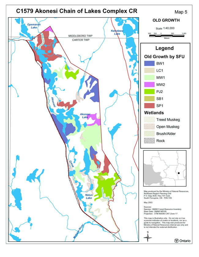
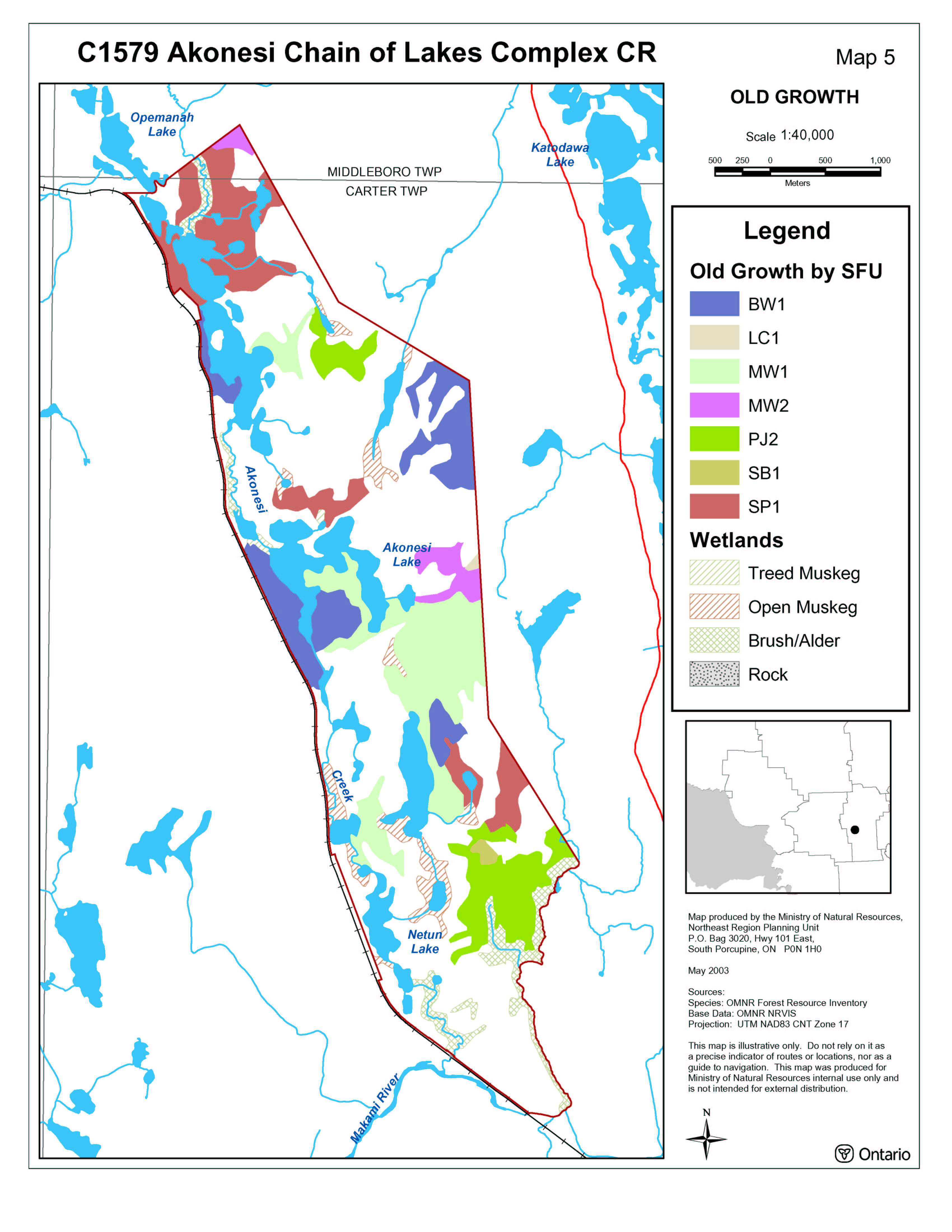
Major forest communities of this conservation reserve total 51.4%. White birch mixedwood composes 26.3% of total area, Jack pine mixedwood, 9.6%, Jack pine predominant conifer, 9.3%, and Jack pine conifer mixed (6.2%) (Taylor et al., 2000; Map 8.2.1).
Forest communities larger than twenty hectares include Jack pine pure, Black spruce mixedwood, White birch predominant hardwood, Jack pine dominant conifer, White spruce conifer mixed, Black spruce dominant conifer and Black spruce/ white birch true mixed. These forest communities plus the Forest Resource Inventory designated wetland brush/alder and open muskeg total 33.8% of the total area.
Other forest communities present include White birch/ Black spruce true mixed, Black spruce conifer mixed, White birch hardwood mixed, Poplar mixedwood, Jack pine/ white birch true mixed, Black spruce pure and Black spruce predominant conifer.
The majority of the conservation reserve is stocked at greater than 60% (Map 8.2.2) and is aged between 60 and 119 years. Areas with forest stands older than 120 years occur in three locations throughout the site include white birch, jack pine and black spruce (Bridge et al., 2000; King et al., 2003; Map 8.2.3).
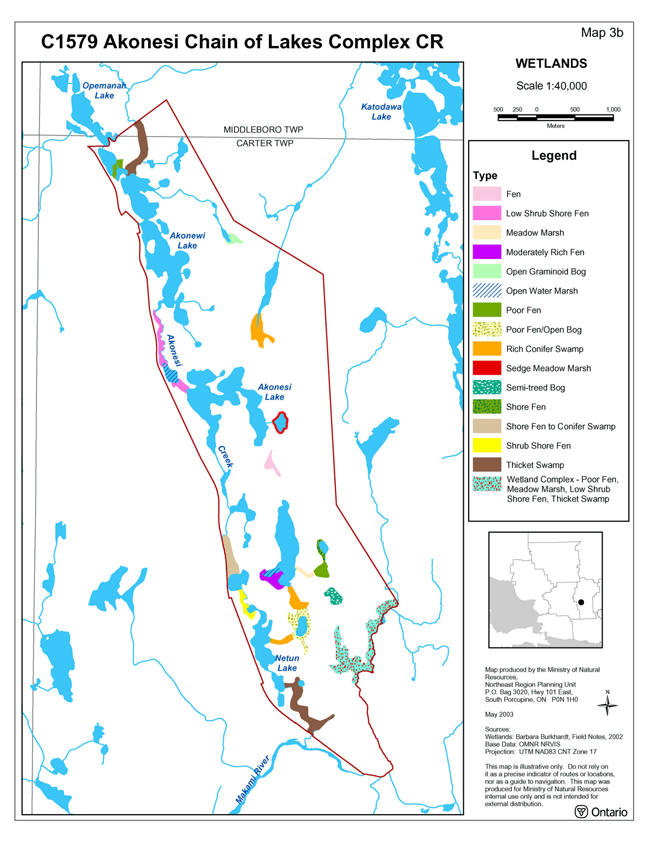
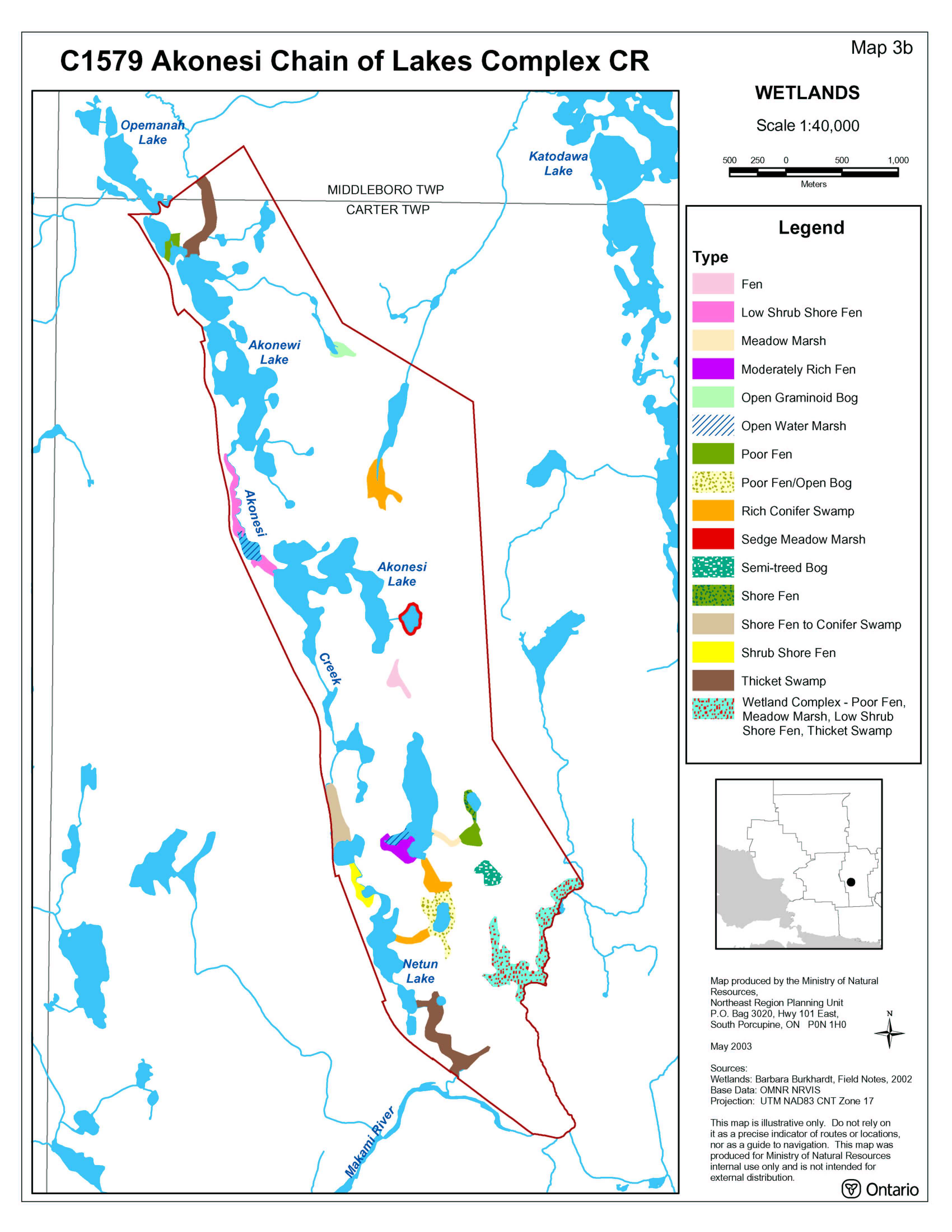
Wetlands within the conservation reserve are more abundant in the south due to lower elevations than the north. Wetland areas include a mixture of shore fens, poor fens, meadow marshes, conifer swamps, thicket swamps and a semi-treed bog (King et al., 2003; Map 8.2.4).
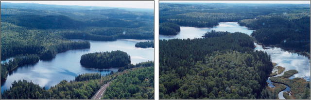
Photo 1 & 2: Eastern boundary along railway (left) and Akonesi Lake (right) (Barb Burkhardt, 2002)
5.1.2 Earth science
The Akonesi Chain of Lakes Complex Conservation Reserve is underlain predominantly by granitic rocks of the Superior Province, Precambrian Shield (Kristjansson, 2002). The provincial landform coverage (OFRI) divides the conservation reserve in a northwest-southeast trend. The eastern portion of the conservation reserve is classified as weakly broken ground moraine while the northern quarter of the site contains moderately broken ground moraine. The majority of the western portion is classified as weakly broken outwash deposit with moderately broken outwash deposit around Akonewi Lake.
Further classification has identified the western lowland area of the site as Ice-Contact Stratified Drift deposits with esker-kame-kettle complex and the eastern half as Bedrock-Drift Complex with drift cover predominantly till (Kristjansson, 2002). The Ice-Contact Stratified Drift Deposits (also known as esker-kame-kettle complex) contains both numerous kettle holes and esker ridges. The esker ridges generally range from 200 to 400 metres long; the kettle holes contain lakes. There are pockets of organic deposits and small areas of Bedrock-Drift Complex throughout the conservation reserve. Glaciofluvial outwash deposits are found in the extreme south of the conservation reserve (Kristjansson, 2002).
5.1.3 Quality of present representation
The quality of the representation or the current characteristics of the natural features found within the conservation reserve are as important as the overall representative features that are being protected. A number of criteria are considered in evaluating a site including: diversity, ecological factors, condition, special features and current land use activities.
a) Diversity
Diversity is a measure of the site’s life and earth science heterogeneity. It is based on the number and range (variety) of the natural landscape features and landforms of earth science values and the richness and evenness of the life science component.
Based on the size of the site, the number of forest communities, developmental stage and earth science features, the diversity rating of the conservation reserve is considered to be high. The initial analysis identified 57 landform:vegetation combinations (Bridge et al., 2000). Extremely small areas and landform:vegetation combinations not deemed to contribute to the diversity rating were removed, decreasing the landform: vegetation combinations to 38. Inclusion of a wetland evaluation will maintain the high diversity rating for the conservation reserve (Arnup et al., 1999). Eskers, kettle holes and ice-contact slopes add to the diversity to the site creating different communities. Blowdown has occurred throughout the Jack–pine-dominant-conifer forest community, changing its species composition and development stage.
Evenness is a measure of the number of different communities that control the vegetative nature of the site. This conservation reserve is dominated by three forest communities: Jack pine (Pj predominant conifer, Pj mixedwood) and White birch (Bw mixedwood). These top three communities cover 45% of the total area of the conservation reserve. When Standard Forest Units (SFUs) are considered, jack pine and white birch forest communities (SFUs PJ1, MW1 and BW1) further dominate the conservation reserve by covering 58% of the total area.
b) Ecological factors
Ecological factors refer to current design of the conservation reserve including its size, shape and the ability of the site to maintain itself over time (Thompson, 1999). The ability of a site to buffer the core areas from adjacent land uses, its general location and location within the greater managed ecosystem will influence the site’s viability over time and be important factors in maintaining overall ecosystem health.
A site’s boundaries should be created to include the greatest diversity of life and earth science features to provide the maximum ecological integrity possible. It should be ecologically self-contained, bounded by natural features and include adequate area to buffer the core ecosystems from adjacent land use activities (OMNR 1992). The western boundary of the conservation reserve follows the CNR railway line. While the railway line is not a natural feature, it is easily defined and therefore provides protection to the core values within the conservation reserve. Approximately half of the conservation reserve’s boundary is vectored, resulting in several perimeter forest communities being fractured and too small to add to the diversity of the conservation reserve. These fractured communities, however, do provide some protection to other core values within the conservation reserve.
The shape of the conservation reserve is important. The Akonesi Chain of Lakes Complex Conservation Reserve is long and fairly narrow. A rounder shape is more beneficial to capturing intact core communities and providing protection from adjacent land use activities. The use of creeks and lakes along the eastern edge of the conservation reserve would provide a biological boundary and would better protect core values within the site (King et al., 2003). This along with its long, narrow shape, which renders the conservation reserve more vulnerable to external disturbance, are good reasons to consider adding additional lands to Akonesi Chain of Lakes Complex Conservation Reserve as opportunities arise.
c) Condition
Condition is the degree of past human and natural disturbances observed or recorded for the site. The disturbance rating of this conservation reserve is low, as less than 10% of the area is currently under known disturbance.
Forest harvesting occurred within the northeast corner of the conservation reserve in 2000. The area was tree planted in the spring of 2000. Aerial spray was not used.
Harvesting has also occurred along the southern boundary of the conservation reserve. The southern section of the conservation reserve appears to have been hit by a microburst evidenced by the blowdown and the height at which the trees were broken off creating excellent snag habitat.
A commercial outpost camp exists on Akonewi Lake; a private recreation camp can be found along Carter Township Lake #3.
d) Special features
Special features may include interesting landscapes, habitats or vistas, Species at Risk (SAR) and other earth and life science features such as broader landscape elements that contribute to the natural heritage richness of Ontario. The chain of lakes, including Akonewi, Akonesi and Netun Lakes and Akonesi Creek which joins them, runs the length of the conservation reserve and are a significant and beautiful feature of this site. The northern lakes have distinct ridges and points and there is a series of esker ridges in the south-central portion of the conservation reserve (King et al., 2003).
Bald eagles are known to make use of the area.
e) Current land use activities
Current land uses include fishing, baitfish harvesting, hunting, commercial trapping and commercial hunting.
5.2 Social/economic interest
This section addresses the contribution of the Akonesi Chain of Lakes Complex Conservation Reserve to the local economy and society through the opportunities it represents and the importance of these opportunities.
5.2.1 Local communities
The Akonesi Chain of Lakes Complex Conservation Reserve is northwest of the Town of Gogama. This area provides recreational/commercial opportunities for the residents of and visitors to the area.
During the hunting and fishing seasons, tourism brings economic benefits to Town of Gogama and to the local outfitters. Other recreational/commercial activities that may be found within the Akonesi Chain of Lakes Complex Conservation Reserve include canoeing, summer camping, ATVing, landscape viewing, snowmobiling and nature activities (James, 2003).
5.2.2 Indigenous peoples
The Akonesi Chain of Lakes Complex is located within Nishnawbe-Aski Nation, Treaty 9, and the Abitibi/Temiscamingue Métis Nation of Ontario harvesting area. Consultation with Aboriginal communities will occur with respect to projects or planned activities that have the potential to adversely impact the exercise of Treaty and/or Aboriginal rights.
5.2.3 Ministry of northern development and mines and the mining industry
In March 2002, the Ministry of Northern Development and Mines and the MNRF came to a joint decision regarding mining issues and Ontario’s Living Legacy sites. No new exploration will be permitted on Crown land within OLL sites in the future.
Within Akonesi Chain of Lakes Complex Conservation Reserve, there is a large elliptical zone (35 km X 40 km) of naturally occurring, highly anomalous dispersion of uranium in lake sediment. This geochemical anomaly is in the 70 percentile (> 2.7 ppm U) of regional survey results with a large number of samples in the 90 percentile (>11.8 ppm U). This uranium anomaly has co-incident elevated levels of arsenic (>3 ppm), vanadium (>69 ppm) and mercury (>250 ppb) detected in the lake sediment survey (Geological Survey of Canada, 1987).
5.2.4 Other government agencies, departments or Crown Corporations
MNRF Timmins District is working with the East Fire Region – Timmins Fire Management Headquarters to develop a fire management direction that protects the values found within the conservation reserve. The current fire management strategy identifies the Akonesi Chain of Lakes Complex Conservation Reserve within the intensive zone. Within the intensive zone, full suppression mandates that every fire must receive a response and is actioned aggressively.
5.2.5 Non-government organizations and other industry interests
Both the Partnership for Public Lands (PPL) and the Ontario Federation of Anglers & Hunters (OFAH) have identified an interest in the Akonesi Chain of Lakes Complex Conservation Reserve.
5.3 Natural heritage stewardship
The Akonesi Chain of Lakes Complex Conservation Reserve’s distinct contribution is a combination of life science preservation, and educational and recreational opportunities. The Akonesi Chain of Lakes Complex Conservation Reserve also offers scientists, educators and recreationalists opportunities to learn about the site and enjoy its value. Akonesi Chain of Lakes Complex Conservation Reserve should be recognized for its provincially significant life science features and measures should be considered to minimize further impacts to the site (King et al., 2003).
By allocating these lands to the parks and protected areas system through regulation the province has ensured a certain level of permanence for the conservation reserve and its values from industrial activities that may exist in the larger general use or more extensively managed landscape.
5.4 Fisheries and wildlife
Akonesi Chain of Lakes Complex Conservation Reserve is found within Wildlife Management Unit (WMU) 31. Game and furbearer species which inhibit the area include furbearers (e.g. beaver, lynx, marten and mink), large mammals (e.g. moose and black bear) and birds (e.g. ruffed and spruce grouse).
Lakes within the conservation reserve contain walleye, northern pike and yellow perch. Akonewi Lake is commonly fished for northern pike and walleye, Akonesi Lake for pike and Netun Lake for walleye (James, 2002). Walleye spawning areas have been identified along Akonesi Creek in four different locations within the conservation reserve.
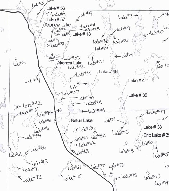
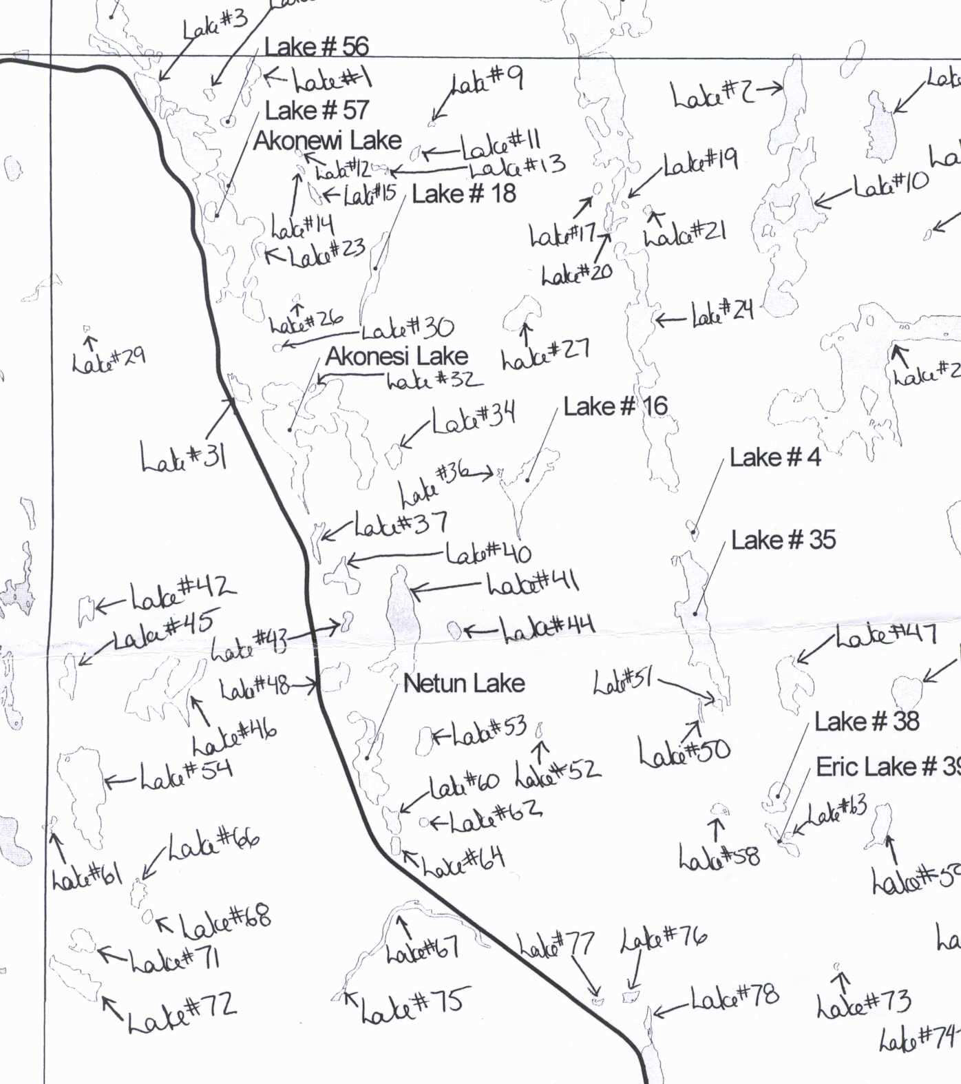
Surveys have occurred for Akonewi Lake, Carter Township Lake #56 and Carter Township Lake #57 (Table 2; Map 8.3). Lake locations are found on Map 8.3. Akonewi Lake is used by a local outfitter for fly-in fishing trips. A set of rapids with excellent spawning substrate and water flow for walleye exists below the beaver dam on the outlet from Akonewi Lake. This area may possibly be used by spawning walleye from Akonesi Lake, Carter Township. Beaver dams exist on the northern inlet and outlet.
Table 2: Lake descriptions
| Lake names | Description | Location/access | Fish species | Other species |
|---|---|---|---|---|
| Akonewi Lake OMNR, 2003c). | 54.9 ha | 19.0 k, by air N/NW of Gogama or 20.0 km N/NW of Gogama on CNR line. | Northern Pike; Muskellunge, Yellow Perch; Iowa Darter; Spottail Shiner; Slimy Sculpin; Walleye, Lake Whitefish, Common White Sucker. | Heavy growth of coontail, pondweed and sedges at the north end of the lake around the two perennial inlets and in the narrows to the north bay of lake; minnows, leeches, crayfish and invertebrates. |
| Carter Lake #56 (OMNR, 2003c). | 1.3 ha; Shallow (<2 m); Growing in around sides with sweet gale; Outlet in to Akonewi Lake is non-perennial springs; spring water is cold (<16°C); Dissolved oxygen was good; Water releasing gases (i.e. bubbling). | Air to Akonewi Lake 19.0 km N/NW |
No minnows were found or seen; weeds and grasses seen at the bottom of pond with shoreline covered with detritus, muck and logs; no suitable spawning areas. | |
| Carter Lake #57 (OMNR, 2003c). | 1.8ha; Outlet joined to Akonewi; Sweet gale entirely surround pond; Little vegetation in lake; One section of emergents on South East Tip; Lake filling in with detritous and sweet gale. | Air to Akonesi Lake, 19 km N/NW of Gogama then portage 10 m. | Iowa Darter; Golden Shiner; Yellow Perch. |
Bear management areas GO-31-060 and GO-31-059, trapline G013 and one baitfish harvesting license overlap the conservation reserve. Trails running along water bodies are used by trappers and hunters. A remote commercial outpost camp is located on the Akonewi Lake.
5.5 Cultural heritage stewardship
There are no known cultural heritage values within the Akonesi Chain of Lakes Complex Conservation Reserve though no detailed research has been conducted as of this date to document possible cultural heritage values. Cultural heritage values may be present within the conservation reserve.
5.6 Land use/current or past development
Mining and surface rights have been withdrawn from staking within the conservation reserve boundaries under the Mining Act (RSO 1990 Chapter M.14).
Two land use permits exist within Akonesi Chain of Lakes Complex Conservation Reserve. A commercial outpost camp exists along the northeast saddle of Akonewi Lake. A private recreational camp exists along the northwestern boundary, east of the railway.
5.7 Commercial use
The commercial use of the Akonesi Chain of Lakes Complex Conservation Reserve includes fishing, baitfish harvesting, hunting and fur harvesting. Other commercial uses such as forestry, hydroelectric development, mining activities and aggregate operations do not occur within this site and are no longer permitted within the conservation reserve.
5.8 Tourism/recreational use/opportunities
Current recreational uses and opportunities of the site include canoeing, camping, snowmobiling, ATVing, viewing and nature activities (James, 2003). There are currently no new proposals for recreational or tourism uses within Akonesi Chain of Lakes Complex Conservation Reserve.
The proximity of the Akonesi Chain of Lakes Complex Conservation Reserve to the Tatachikapika canoe route and Makami River canoe route circle offers opportunity for the development of a canoe route through the Akonesi Chain of Lakes Complex Conservation Reserve.
Under Management Guidelines for future proposals, an evaluation of any proposal should include the following:
- Ensure natural heritage values identified herein are protected and the requirements outlined in the PPCRA and associated regulations, the Class Environmental Assessment for Provincial Parks and Conservation Reserves (OMNR 2005), and the Test of Compatibility from PL 3.03.05 (OMNR, 1997) are used,
- Different options are proposed for the development including the null option, and
- Proposed changes in use are considered with appropriate public and Aboriginal consultation.
5.9 Client services
Visitor services will primarily deal with responding to inquires about the basic level of information such as natural heritage representation and appreciation, wildlife viewing opportunities, access and boundaries. The role of Akonesi Chain of Lakes Complex Conservation Reserve within the greater provincial parks and protected area system will be addressed when meeting with clients.
6.0 Management guidelines
6.1 Management planning strategies
Once established, protected areas will be managed to retain and/or restore natural features, processes and systems. They will also meet previous commitments identified in Ontario’s Living Legacy Land Use Strategy and provide opportunities for compatible research, education and outdoor recreation activities (OMNR, 1999). Management and protection of the site will be under the direction of the District Manager of the Timmins District MNRF. The management of this conservation reserve will meet the goal of protecting the natural heritage features while permitting compatible activities to continue by screening proposals through the Test of Compatibility. All types of proposed development would require a detailed Test of Compatibility to be conducted to ensure that the features would not be impacted in any way. These types of assessments would occur on a case-by-case basis by, the Timmins District MNRF. Management strategies will also be consistent with the objectives of increasing public awareness, promoting responsible stewardship, providing marketing opportunities, and identifying inventory, monitoring, assessment and reporting potential.
6.2 "State of the resource" management strategies
The following section will describe specific management strategies to maintain, protect and enhance the existing natural heritage values and land use activities of the Akonesi Chain of Lakes Complex Conservation Reserve. A complete list of permitted activities can be found in the permitted use tables (Appendix B).
6.2.1 Natural heritage stewardship
Natural heritage values will be managed in such a way as to mitigate and prevent any further damage to either the earth science features or the life science values. All earth science and life science features will be protected by defining compatible uses, enforcing regulations and monitoring and mitigating issues. No additional construction, maintenance, or further upgrade to trails will be permitted.
The MNRF recognizes fire as an essential process in the maintenance and renewal of ecological and ecosystem health of conservation reserves. Fire Protection will be carried out in accordance with The Wildland Fire Management Strategy (MNRF 2014), which provides direction for how the MNRF manages wildland fire across Ontario
Whenever feasible, the MNRF fire program will endeavour to use "light on the land" techniques, which do not unduly disturb the landscape, in the Akonesi Chain of Lakes Complex Conservation Reserve. Examples of "Light on the land" techniques may include, and are not limited to:
- Using natural openings for helicopters pads
- Ensuring camp locations are built outside the conservation reserve; and/or
- Limiting the use of heavy equipment within the conservation reserve
Fire and resource managers will identify those areas in which, and the specific conditions under which prescribed fires may be used to meet ecological or resource management objectives. These management objectives will be developed with public consultation prior to any prescribed burning, and reflected in future refinements of this SCI. Any future prescribed burns will follow approved MNRF policy and be consistent with the Class Environmental Assessment for Provincial Parks and Conservation Reserves (OMNR 2005).
The introduction of exotic and/or invasive species will not be permitted. Programs may be developed to control forest insects and diseases in the conservation reserve where these threaten significant heritage, aesthetics, or economic values. Where control is desirable and possible, it will be directed as narrowly as possible to the specific insect, disease or plant. Where action is necessary, biological control will be the preferred option whenever feasible.
Vegetation communities should not be disturbed any further through unnecessary clearing or fuelwood collection or any other use. Natural succession will be allowed to occur through passive management.
The collection/removal of native vegetation and parts thereof will not be permitted. However, subject to the Test of Compatibility, the District Manager may authorize the collection of plants and/or parts for the purposes of rehabilitating degraded sites within the reserve if required and for research or scientific study.
For this site to continue to contribute as a heritage estate through its permanent protection of our life science history, the permitted uses need to be enforced. The site should be promoted for its educational opportunities. The role of this landform as a provincial benchmark should be studied further and studies should be conducted to determine possible rare, vulnerable or threatened species habitat. Natural forest succession could be monitored to determine the natural climax community.
Timmins District MNRF will provide leadership and direction for maintaining the integrity of this site as a protected area. Research, protection, education and interpretation of natural heritage features of the site will be encouraged and fostered through local and regional natural heritage programs and initiatives.
6.2.2 Fisheries and wildlife
Fisheries and wildlife resources will continue to be managed in accordance with policies and regulations prevailing in the area and under the direction of the District Manager. Provincial legislation and policies will dictate management and enforcement objectives for this conservation reserve.
Existing fishing, baitfish harvesting, trapping and hunting will be permitted to continue by local outfitters, trappers, baitfish harvesters and the general public. First Nation Treaty Rights with regard to fish and wildlife activities will be respected. New commercial outfitting, outpost, hunting camps or trap cabins will not be permitted within the boundaries of the conservation reserve.
6.2.3 Cultural heritage values
It is not known if cultural heritage values exist in the Akonesi Chain of Lakes Complex Conservation Reserve. MNRF will review new projects or proposals in accordance with a Technical Guideline for Cultural Heritage Resources for Projects Planned Under the Class Environmental Assessment for MNR Resource Stewardship and Facility Development Projects and the Class Environmental Assessment for Provincial Parks and Conservation Reserves (OMNR 2006) in order to identify cultural heritage resources and/or mitigate potential negative impacts to these resources.
Research and studies should be conducted to determine the potential and/or existence of cultural or archeological resources.
6.2.4 Social/economic interest
The economic contribution of the Akonesi Chain of Lakes Complex Conservation Reserve to the local communities may be increased by implementing marketing strategies that draw tourism to the area.
Socially, this area provides recreational opportunities for the local people and tourists to enjoy for their own health and well-being. The people of Ontario will generally benefit from this conservation reserve through direct enjoyment of the area or through the knowledge that a component of our earth science and glacial history has been preserved. Other interest groups, such as colleges and universities, can benefit from this conservation reserve as a place to study natural features and processes.
6.2.5 Land use/past and existing development
No road realignments, telecommunications and resource networks will be allowed to cross Akonesi Chain of Lakes Complex Conservation Reserve and interrupt its natural state.
The sale of land and creation of new recreation camps will not be permitted within the conservation reserve.
6.2.6 Commercial activities
Commercial activities such as fur harvesting, baitfish harvesting and bear management areas will be managed according to prescriptions in the Land Use Strategy (OMNR, 1999). Trapline operations will be permitted to continue since there are no demonstrated conflicts between these activities and the values being protected. Existing bear management areas will be permitted to continue, including license transfer; however, new operations will not be permitted.
Commercial forest harvest, hydroelectric development, mining activities and aggregate extraction are not permitted within the conservation reserve.
6.2.7 Tourism/recreation
The tourism and recreation opportunities present in the Akonesi Chain of Lakes Complex Conservation Reserve will be managed by permitting current activities to continue unless shown to have significant impact on conservation reserve values.
6.2.8 Client services
Under the direction of the District Manager, Timmins District staff will respond to public, non-government organizations (NGOs), industry and MNRF partner requests for basic information on Akonesi Chain of Lakes Complex Conservation Reserve.
6.3 Promoting inventory, monitoring, assessment, reporting and research
The Akonesi Chain of Lakes Complex Conservation Reserve provides educational opportunities through its existence. Scientific research by qualified individuals or institutions, which contributes to the knowledge of natural and cultural history and to environmental and recreational management, will be encouraged. Requests or applications to conduct research will be filtered through the Northeast Region MNRF, to ensure that the studies are non-invasive and that no values will be damaged in the research process. Research programs will be subject to ministry policies and other legislation.
Approved research activities and facilities will be compatible with the protection objective. Permanent plots or observation stations may be established for long-term trials. The MNRF may approve the removal of any natural or cultural specimen by qualified researchers. Any materials removed will remain the property of the MNRF. Any site that is disturbed will be rehabilitated as closely as possible to its original state.
Other specific research projects that could be undertaken may include: the effects of human disturbance on the landform, determination of the existence of any rare, vulnerable or threatened species, vegetation climax community, or wind throw and harvest area re-growth. Additional life and earth science inventories may be completed.
6.4 Implementation and plan review
This Statement of Conservation Interest will take effect immediately following approval by the Northeast Regional Director. Implementation activities will primarily involve monitoring to ensure adherence to the management guidelines. Other implementation activities may include responding to any inquiries about the site. Implementation of this Statement of Conservation Interest and management of the conservation reserve are the responsibility of the Timmins District Manager and District staff.
This Statement of Conservation Interest should be examined, as per the schedule outlined in the PPCRA to determine if it is providing adequate direction and protection for the natural heritage values. If changes in management direction are needed at any time, the significance of the changes will be evaluated. Administrative updates to the SCI may be considered and approved by the Timmins District Manager and Regional Director without further consultation. In assessing amendments, public and Indigenous consultation may occur, as necessary. All updates and amendments will follow the process outlined in the Protected Areas Planning Manual (MNRF 2014).
Inventory, monitoring, assessment, and reporting should be ongoing and findings should be amended to the Statement of Conservation Interest as the studies are completed or at the time of the regular review. After the initial review, the Statement of Conservation Interest will be examined as per the schedule outlined in the the Statement of Conservation Interest will be examined as per the schedule outlined in the PPCRA. Additional planning will be linked to the inventory, monitoring, assessment, and reporting, research findings and any new information. Adaptive management strategies will be used when new information has significant implications for the current Statement of Conservation Interest.
6.5 Marketing
The Akonesi Chain of Lakes Complex Conservation Reserve will be recognized as a distinctive protected area having a provincially significant earth science mature jack pine and poplar on Ice-Contact Stratified Drift Deposits and Glaciofluvial Outwash Deposits. Marketing efforts to increase use are not an objective and will be kept to a minimum.
7.0 References
Arnup, R., Racey, G.D. and Whaley, R.E. , 1999. Training manual for photo interpretation of ecosites in northwestern Ontario. NWST Technical Manual TM-003.127p.
Bridge, S., Watt, R., Lucking, G., and Naylor, B., 2000. Landscape analysis for forest management planning in boreal northeastern Ontario. OMNR, Northeast Science & Technology, 36p.
Crins, W.J., and Uhlig, P.W. 2000. Ecoregions of Ontario: Modifications to Angus Hills' Site Regions and Districts. Ontario Ministry of Natural Resources.
Department of Lands and Forests, 1964. A History of Gogama Forest District. No. 11 District History Series. Ontario Department of Lands and Forests.
Geological Survey of Canada, 1987. Open File 1640, Regional Geochemical Reconnaissance Map 105-87.
Hills, G.A., 1959. A Ready Reference to the Description of the Land of Ontario and its Productivity. Ontario Department of Lands and Forests.
James, L. 2003. Recreation Inventory Checklist: C1579 Akonesi Chain of Lakes Complex Conservation Reserve. Ontario Ministry of Natural Resources.
Kristjansson, F.J., 2003. Earth Science Inventory Checklist – Akonesi Chain of Lakes Complex Conservation Reserve C1579. Ontario Ministry of Natural Resources.
King, L., Burkhardt, B., and Longyear, S., 2003. Akonesi Chain of Lakes Complex Conservation Reserve (C1579): Life Science Checksheet – Step 4. Ontario Ministry of Natural Resouces.
MNRF, 2017. Protected Areas Examination Report – Akonesi Chain of Lakes Conservation Reserve (C1579). Unpublished information.
OMNR, 1997. Conservation Reserves Policy 3.03.05. Ontario Ministry of Natural Resources.
OMNR, 1999. Ontario’s Living Legacy Land Use Strategy. Ontario Ministry of Natural Resources.
OMNR, 2000. Beyond 2000 MNR Strategic Direction. Ontario Ministry of Natural Resources. Peterborough, Ontario.
OMNR, 2002. MNR districts and major basins of Ontario. Ontario Ministry of Natural Resources.
OMNR, 2003a. A Class Environmental Assessment for MNR Resource Stewardship and Facility Development Projects. Ministry of Natural Resources Environmental Assessment Report Series. Ontario Ministry of Natural Resources. Queen’s Printer.
OMNR, 2005. A Class Environmental Assessment for Provincial Parks and Conservation Reserves. Queen’s Printer for Ontario. Ontario. 120pp.
OMNR. 2006. A Technical Guideline for Cultural Heritage Resources for Projects Planned Under the Class Environmental Assessment for MNR Resource Stewardship and Facility Development Projects and the Class Environmental Assessment for Provincial Parks and Conservation Reserves. 45pp.
OMNR, 2014. Ontario’s Protected Areas Planning Manual. Queen’s Printer for Ontario. Peterborough, Ontario. 33pp.
Poser, S.F., 1992. Report on the Status of Provincial Parks in Site Regions and Districts of Ontario. Ontario Ministry of Natural Resources.
Rowe, J.S., 1972. Forest Regions of Canada. Department of Fisheries and the Environment, Canadian Forestry Service.
Taylor, K.C., R.W. Arnup, B.G. Merchant, W.J. Parton and J. Nieppola. 2000. A field guide to forest ecosystems of northeastern Ontario. 2nd Edition. Northeast Science and Technology NEST Field Guide FG-001.
Thompson, J.E., 1999. Cheatsheet "Building the System". Ontario Ministry of Natural Resources.
8.0 Maps
8.1 Planning area
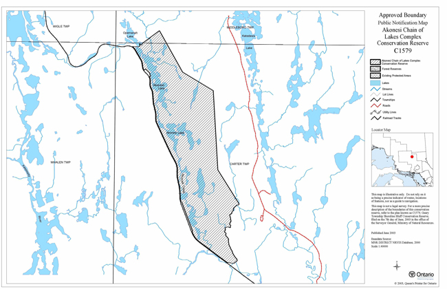
8.2 Life science checksheet maps
8.2.1 Forest communities
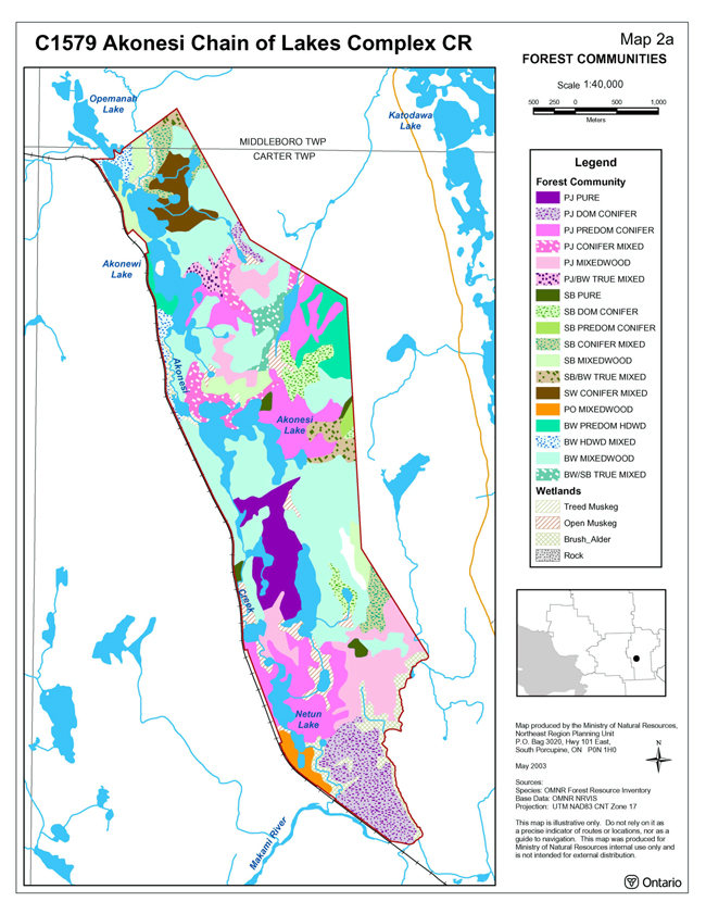
Enlarge Map For Forest Communities
8.2.2 Stocking distribution

Enlarge Map For Stocking Distribution
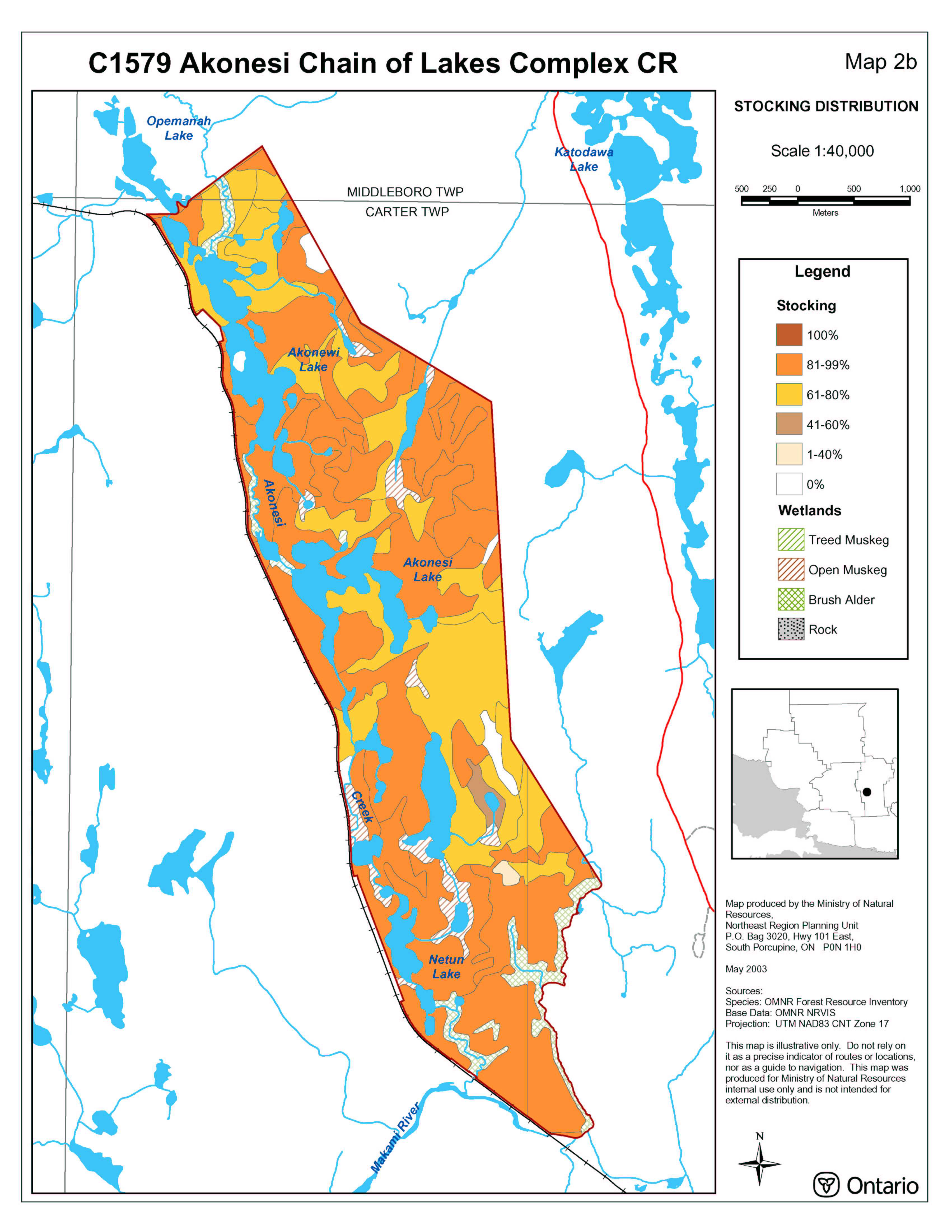
8.2.3 Old growth
8.2.4 Wetlands
8.3 Lake locations - Carter Township
Enlarge Map For Lake Locations - Carter Township
9.0 Appendices
9.1 Appendix A: Physical site description
Table 3a: Physical site description of ecoregion
| Ecoregion | Lake Abitibi Site Region/Ecoregion – 3E |
|---|---|
| Characteristics | Moderately to gently rolling bedrock, generally covered by deep deposits of clay, silt and sand (Hills, 1959). |
| Vegetation | Good stands of spruce, fir, poplar and birch on moderately sloping fresh sites; White and red pine occur on sand ridges; American elm and white cedar are found only in protected valleys. |
| Climate | Mid-humid, mid-boreal. |
Table 3b: Physical site description of ecodistict
| Ecodistrict | Foleyet Ecodistrict 3E-5 (Crins and Uhlig, 2000) |
|---|---|
| Characteristics | Gently rolling plains of thinly covered rock knob, sandy outwash and silty depressions (Hills 1959; Poser 1992). |
| Soils | Acidic and locally overlain by low-base and low lime materials (Hills 1959; Poser 1992). |
Table 3c: Physical site description of forest section
| Forest section | Missinaibi-Cabonga (B.7) within Boreal Forest Section |
|---|---|
| Vegetation | Section B.7 follows the height of land in central Ontario and Quebec and contains species of the Boreal Forest Region but certain species from the Great Lakes-St. Lawrence forest can be found as isolated individuals or in small patches. The predominant forest is mixed in character, consisting of balsam fir, black spruce and white birch with scattered white spruce and trembling aspen. The results of birch dieback and spruce budworm damage in balsam fir are evident in vast areas. The topography is rolling with numerous flats along the rivers and lake shores (Rowe 1972). |
9.2 Appendix B: Conservation Reserves Policy
Amended by Ontario’s Living Legacy Land Use Strategy, September 26, 2000
Introductory notes:
- According to conservation reserve policy, and statements made in the Ontario’s Living Legacy Land Use Strategy (LUS), all uses within conservation reserves are subject to a "test of compatibility", that is, the use must be compatible with the conservation of the ecological features for which the site was identified (e.g., landforms, vegetation communities, hydrology, species, etc)
- The following detailed clarification of conservation reserve policies should be read in the context of the Provincial Parks and Conservation Reserves Act, the policies outlined in this Statement of Conservation Interest, and Treaty and Aboriginal rights.
Definitions:
- Existing Policy: Statements of policy for conservation reserves established prior to the OLL-LUS, primarily as outlined in the Conservation Reserve Policy and Procedure, February 1997
- OLL-Land Use Strategy Policy: Statements of policy in the LUS applicable to the recommended conservation reserves in the OLL planning area
- Policy Clarification: Statements that clarify policy direction with respect to new and/or existing OLL conservation reserves within the OLL planning area
Industrial activities
| Issue and activity | Existing policy | OLL: Land Use Strategy Policy | Policy clarification |
|---|---|---|---|
| Commercial timber harvest | Not permitted | Not permitted | Consistent with existing policy |
| Cutting of trees by leaseholders, cottagers and other property owners for fuelwood and other small- scale uses | No explicit policy | No policy stated | No fuelwood permit will be authorized. |
| Timber salvage/sunken log retrieval | No explicit policy | No policy stated | If provided for in an SCI or RMP, standing, fallen or sunken trees may be removed for resource management purposes. Such trees may be marketed if economical. |
| Mineral exploration | Not permitted | Not permitted | Consistent with existing policy. |
| Mining | Not permitted | Not permitted | Consistent with existing policy. |
| Extraction of peat, soil, aggregate, other materials | Not permitted | No policy stated; existing policy applies | |
| Forest renewal | Forest renewal is not directly addressed in existing policy as it is an activity associated with commercial timber harvesting which is not permitted in conservation reserves. | Not directly addressed | This issue arises where a new conservation reserve was cut recently, and there is a question as to whether the forest company should carry out planned forest renewal work. MNRF's position is that the companies have harvested the areas, and have an obligation to proceed with renewal, unless this requirement is waived by MNRF. If renewal is to occur, the work should normally be carried out by the forest company. Any possible renewal should be reviewed to determine the nature of the renewal proposal and the possible implications for protected area values. Renewal can be conducted where it will be of net benefit to the protected area. To the greatest extent possible, the renewal should be designed to replicate natural conditions (e.g., if planting is carried out, the more random the planting, the better), although the company cannot be expected to carry out renewal that would be beyond the cost of normal renewal activities. Tending should be considered on a case-by-case basis and be driven by the desired outcome of renewal. |
| In all cases of proposed renewal activities, there must be prior review and approval of the proposals by appropriate silvicultural and program staff responsible for the management of the protected area, in order to determine what actions would best support the long-term ecological integrity of the area. | |||
| Hydro power generation | Not permitted | Not permitted | |
| Communications corridors | Existing use permitted to continue; new corridors to be discouraged through planning. | No policy stated; existing policy applies | The intent of the policy is to actively discourage these uses, but it is recognized that in some circumstances there will be no alternatives; this will be determined through planning. |
| Energy transmission corridors | Existing use permitted to continue; new corridors to be discouraged through planning. | No policy stated; existing policy applies | The intent of the policy is to actively discourage these uses, but it is recognized that in some circumstances there will be no alternatives; this will be determined through planning. |
| Transportation corridors | Existing use permitted to continue; new corridors to be discouraged through planning. | No policy stated; existing policy applies | The intent of the policy is to actively discourage these uses, but it is recognized that in some circumstances there will be no alternatives; this will be determined through planning. |
| Resource access roads | Existing resource access roads can continue to be used. New resource access roads will not be permitted. | Existing forest access roads may occur within areas identified as recommended conservation reserves. These roads may be essential for continued access beyond the recommended conservation reserve for forest management or recreational purposes. Where alternative access does not exist or road relocation is not feasible, these roads will continue to be available for access. Continued use will include maintenance and may include future upgrading. |
MNRF has made a commitment through the Ontario Forest Accord that, in the case of new linear shaped conservation reserves, provision will be made for the timely implementation of a limited number of crossings to provide access to timber harvest areas that would otherwise be uneconomical to access. These crossings should be identified by December 31, 1999. Once the protected areas are in regulation, decisions on crossings will normally be made as part of the management planning process. |
| New resource access roads will not be permitted with the exception of necessary access to existing mining claims and leases or for future mineral exploration and/or development. | New roads for resource extraction will not be permitted, except for those identified in Forest Management Plans before March 31, 1999 and for which no viable alternative exists. | ||
| Private access roads | No explicit policy | No explicit policy The general policy on honouring "existing commitments" applies to commitments made to private access roads prior to 29 March 1999. |
New private access roads, including additions to existing roads, will not be permitted except where there are existing commitments. The maintenance of existing private access roads will be permitted, however, the upgrading of existing private access roads will not be permitted. Where MNRF made a commitment, prior to March 29, 1999, to permit a private access road within a recommended protected area, the road proposal will be subject to completion of a public planning process. The Field Environmental Planning Procedure from the Small Scale Class E.A. is recommended as a suitable process. In addition, the Ministry will concurrently prepare an Interim Management Statement (IMS) or a Statement of Conservation Interest (SCI), depending on whether the area in question is a park or a conservation reserve. |
Recreational activities
| Issue and activity | Existing policy | OLL: Land Use Strategy Policy | Policy clarification |
|---|---|---|---|
| Sport fishing | Existing and new uses permitted | Existing and new uses permitted | The Ontario fishing regulations will continue to govern fishing in conservation reserves. |
| Sport hunting | Existing and new uses permitted | Existing and new uses permitted | |
| Facility development | Existing facilities/use may be permitted. New facilities may be considered. | No policy stated; existing policy applies | |
| Non-trail snowmobiling | Use may be permitted for direct retrieval of game only | No policy stated; existing policy applies | |
| Non-trail ATV use | Use may be permitted for direct retrieval of game only | No policy stated; existing policy applies. | |
| Motorized boating | Existing and new uses permitted | No policy stated; existing policy applies | |
| Camping | Use may be permitted | No policy stated; existing policy applies | |
Trails:
|
Existing use permitted to continue. New trails may be permitted. | Existing authorized trails can continue unless there are significant demonstrated conflicts. New trails can be considered through planning. | LUS is consistent with existing policy |
| Private recreation camps | Existing camps permitted to continue. New camps will not be permitted. Transfer requests will be considered in the context of an SCI or RMP for the conservation reserve | Existing authorized recreation camps permitted to continue, and may be eligible for enhanced tenure, but not for purchase of land. | As the LUS is silent on establishment of new seasonal recreation camps, the existing policy will apply (new camps not permitted). In conservation reserves in the OLL planning area, existing private recreational camps, including hunt camps, are eligible for enhanced tenure, but not purchase of lands. Enhanced tenure is defined as anything beyond the term and form of current tenure. Enhanced tenure is not guaranteed. If lands were needed to protect significant natural or recreational values, enhanced tenure would not be granted. A decision to grant enhanced tenure, or to transfer recreational camps will be addressed through a screening process, and preferably in the context of a Statement of Conservation Interest. In the absence of an SCI, decisions arising from the application of screening criteria will be limited to an extension of the term only (up to 10 years) and will not include any change in the nature of the tenure from that existing at the time of the request. Requests for the transfer of recreation camp tenure may be approved subject to the application of the screening criteria. If an existing recreation camp holder wishes to relinquish their tenure and to sell any existing improvements, MNRF will consider purchase of the improvements. |
Commercial activities
| Issue and activity | Existing policy | OLL: Land Use Strategy Policy | Policy clarification |
|---|---|---|---|
| Fishing | Existing use may be permitted to continue. New operations may be permitted. | Existing use permitted to continue, unless there are significant demonstrated conflicts. New operations can be considered subject to the 'test of compatibility'. | The LUS is consistent with existing policy. The existing policy and the LUS are both silent, however, on transfer requests. Under existing policy, requests for transfer will be considered within the context of the SCI or RMP prepared for the conservation reserve. For the new conservation reserves recommended in the LUS, transfer requests will be dealt with on an ongoing basis, and not deferred until completion of a SCI or RMP. |
| Bait-fish harvesting | Existing use permitted to continue. Transfer requests will be considered in the context of the SCI or RMP for each conservation reserve. New operations may be permitted. | Existing use permitted to continue, unless there are significant demonstrated conflicts. New operations can be considered subject to the 'test of compatibility'. | The LUS is consistent with existing policy. The LUS is silent, however, on transfer requests; Requests for transfer will be dealt with on an ongoing basis, and not deferred until completion of a SCI or RMP. |
| Commercial fur trapping | Existing use permitted to continue. Transfer requests will be considered in the context of the SCI or RMP for each conservation reserve. New traplines may be permitted. | Existing use permitted to continue unless there are significant demonstrated conflicts. New operations can be considered, subject to the "test of compatibility". | The LUS is consistent with existing policy. The LUS is silent, however, on transfer requests. Requests for transfer will be dealt with on an ongoing basis, and not deferred until completion of a SCI or RMP. As part of the determination of whether new trapping would be permitted, the associated trails that would be required should be considered. |
| Trapping cabin | Existing use permitted to continue. New cabins not permitted | Existing policy applies | Repair and replacement of existing cabins should normally be permitted, as long as the scale and function are not significantly altered. The relocation of existing cabins may be permitted if consistent with the protection of natural heritage values and other uses/activities. |
| Outpost camps/tourism facilities | Existing outpost camps permitted to continue. Transfer requests will be considered in the context of an SCI or RMP for the conservation reserve. New outpost camps not permitted | Existing authorized tourism facilities can continue unless there are significant demonstrated conflicts. The operators of tourism facilities can apply to upgrade tenure from LUP to lease. New tourism facilities can be considered during planning for a conservation reserve. | The LUS differs from existing policy in several areas: LUS implies more than outpost camps in discussion of tourism facilities (for eg., main base lodges) new tourism facilities can be considered through planning permit holders can apply to upgrade tenure from LUP to lease. In addition, the LUS is silent on transfer requests. Requests for transfer will be dealt with on an ongoing basis, and not deferred until completion of an SCI or RMP. |
| Commercial bear hunting (tourist operators providing bear- hunting services to non-resident hunters) | Existing use permitted to continue. Transfer requests will be considered in the context of the SCI or RMP for the conservation reserve. New operations not permitted. | Existing use permitted. New operations not permitted. | The LUS is consistent with existing policy. The LUS is silent, however, on transfer requests. Requests for transfer will be considered on an ongoing basis, and not deferred until completion of a SCI or RMP. Bear management areas that have never been active should not be activated. Where BMAs have lapsed, their use should not be reinstated. |
| Wild rice harvesting | Existing use permitted to continue. New operations may be considered. | Existing use permitted to continue, unless there are significant demonstrated conflicts. New operations can be considered, subject to the 'test of compatibility'. | The LUS is consistent with existing policy. The LUS is silent, however, on transfer requests. Requests for transfer will be considered on an ongoing basis, and not deferred until completion of a SCI or RMP. |
| Food harvesting | Existing use may be permitted to continue. New operations can be considered. | No policy stated. Existing policy applies. |
Resource management activities
| Issue and activity | Existing policy | OLL: Land Use Strategy Policy | Policy clarification |
|---|---|---|---|
| Resource inventory | Existing and new inventory activity permitted | No policy stated; existing policy applies | |
| Resource monitoring | Existing and new monitoring activity permitted | No policy stated; Existing policy applies | |
| Fire protection | Forest fire protection will be carried out in accordance with approved Fire Management Strategies unless alternative direction for fire suppression or fire management is approved through an SCI or RMP | No policy stated; existing policy applies | Regional fire management strategies vary across the province. Where aggressive fire suppression is undertaken, a 'light-on-the-land' approach to fire management in conservation reserves is desirable (i.e., minimal use of heavy equipment, trenching, camp construction, tree cutting, etc.). If habitat regeneration becomes an issue in future, prescribed burning could be considered on a per-site basis. |
| Insect and disease | Control of insects and diseases will be addressed on a site basis | No policy stated; existing policy applies | |
| Featured species management | Existing and new featured species management may be permitted | No policy stated; existing policy applies. Some area-specific policies address this activity. | New featured species management activity will not be permitted until a SCI or RMP is prepared. Existing habitat management practices will be reviewed to ensure that they are consistent with the protection of identified natural heritage values. |
Other activities
| Issue and activity | Existing policy | OLL: Land Use Strategy Policy | Policy clarification |
|---|---|---|---|
| Research | Research will be encouraged to provide a better understanding of the natural values protected by a conservation reserve and to advance their protection, planning and management. | No policy stated; existing policy applies. | |
| Collecting | Collecting is not permitted | No policy stated; existing policy applies. | Collecting may be permitted as part of an authorized research project. The issuance of permits will be considered on a per-site basis. |
| Food gathering | Existing and new use are permitted | No policy stated; existing policy applies. | |
| Land disposition | Sale and lease of lands is not permitted. Permitted uses may be authorized by land use occupational authority excluding a sale or lease. Where incompatible uses are currently permitted through land use occupational authority, such uses will be phased out either by cancellation of occupational authority or acquisition as funds are available. | Sale of lands is not permitted with the exception of some types of minor dispositions (for eg., the sale of road allowances in front of an existing cottage, the sale of small parcels of land to provide adequate area for the installation of a septic system) where it does not detrimentally affect the values an area is intended to protect. Renewals of existing leases or land use permits are permitted. Requests for transfer of tenure will be considered in the context of the SCI or RMP. New leases or land use permits will be allowed for approved activities. | Commitments to sell or lease Crown land within new conservation reserves in the OLL planning area made prior to the release of the proposed LUS will proceed, subject to meeting all other necessary requirements. |
| Habitat management for wildlife | No explicit policy | No policy stated | Specific management prescriptions will be identified in SCIs and RMPs. No new habitat management will be permitted until an SCI or RMP is prepared. Existing habitat management practices will be reviewed to ensure that they are consistent with the protection of identified natural heritage values. |