Algoma Headwaters Signature Site Management Plan
This document provides policy direction for the protection, development and management of Algoma Headwaters, Goulais River and Aubinadong-Nushatogaini Rivers Provincial Parks and Ranger North Conservation Reserve and their resources.
Algoma Headwaters Signature Site Management Plan
Algoma Headwaters Provincial Park
Goulais River Provincial Park
Aubinadong–Nushatogaini Rivers Provincial Park
Ranger North Conservation Reserve
March 2007
©2007, Queen’s Printer for Ontario
Printed in Ontario, Canada
This publication may be obtained on-line at: www.ontarioparks.com or from the address noted below:
Ministry of Natural Resources
64 Church Street
Sault Ste. Marie, Ontario
P6A 3H3
Current publications of the Ontario Ministry of Natural Resources, and price lists, are available from the address noted below. Bulk orders may involve charges.
Ministry of Natural Resources
Natural Resources Information Centre
300 Water Street
Peterborough, Ontario
K9J 8M5
Telephone inquiries about ministry programs and services should be directed to the Natural Resources Information Centre:
General Inquiry
Find the Ministry of Natural Resources on-line
Copies of this publication are also available in French.
Approval Statement
We are pleased to approve the Algoma Headwaters Signature Site Management Plan which provides direction for the protection and management of this significant area. Algoma Headwaters is one of nine signature sites in Ontario established in 1999. Signature sites were identified for their range of natural and recreational values, and their potential to contribute to future recreation and tourism.
This management plan guides the resource stewardship, operations, and development of the Algoma Headwaters Signature Site, and may be reviewed and revised to address changing issues or conditions, as necessary. This plan pertains to the entire Algoma Headwaters Signature Site, and incorporates management of the four protected areas it contains: Algoma Headwaters Provincial Park, Goulais River Provincial Park, Aubinadong – Nushatogaini Rivers Provincial Park, and the Ranger North Conservation Reserve.
This plan reflects the intent of the Ministry of Natural Resources (MNR)/ Ontario Parks to protect heritage features and values, and to maintain and develop high quality opportunities for outdoor recreation and heritage appreciation for the residents of Ontario and visitors to the province. It frames the management of the four protected areas around their designation, goals, and objectives. In addition, it outlines a prioritized phase-in for the implementation of the direction contained in the plan, with the intent to provide a level of service to visitors in this protected area. A summary of the public consultation carried out during the planning process is also contained in this plan.
We wish to extend our sincere thanks to all those who participated in the various phases of public consultation and Aboriginal dialogue throughout the planning process. The input was an important component in determining the policies in this management plan.
Signed by:
Adair d-Smith
Managing Director
Ontario Parks
Signed by:
Rob Galloway
Regional Director
Northeast Region
Vision Statement for Algoma Headwaters Signature Site
A vision statement has been prepared for the Algoma Headwaters Signature Site to define its long-term strategic direction. All planning, management and operations of the signature site will be in keeping with the intent of this vision statement.
Vision for Algoma Headwaters Signature Site
“The Algoma Headwaters Signature Site will protect the ecological integrity of the area’s natural and cultural landscapes, while providing present and future generations with high quality, year-round recreational opportunities. In a remote, yet accessible setting, the signature site provides the opportunity to experience old growth forests, scenic waterways, and Aboriginal heritage values.
The site is dedicated in perpetuity to the people of Ontario and others for their enjoyment, education and benefit.“
Consideration of the Ministry of Natural Resources
Statement of Environmental Values under the Environmental Bill of Rights
In accordance with the provisions of The Environmental Bill of Rights, the Ministry of Natural Resources (MNR) has prepared a Statement of Environmental Values. The Statement of Environmental Values will consider the Environmental Bill of Rights whenever decisions are being made which might significantly affect the environment, including decisions made during the planning process for the Algoma Headwaters Signature Site Management Plan.
The primary purpose of the Environmental Bill of Rights is “to protect, conserve and, where reasonable, restore the integrity of the environment.“The broad statement of purpose translates into four objectives in MNR’s Statement of Environmental Values:
- To ensure the long-term health of ecosystems by protecting and conserving our valuable soil, aquatic resources, forests and wildlife resources, as well as their biological foundations
- To ensure the continuing availability of natural resources for the long-term benefit of the people of Ontario, leaving future generations a legacy of the natural wealth that we enjoy today
- To protect natural heritage and biological features of provincial significance
- To protect human life, the resource base, and physical property from the threats of forest fires, floods and erosion
The MNR’s Statement of Environmental Values has been considered in the development of this Management Plan for the Algoma Headwaters Signature Site.
1.0 Introduction
The Algoma Headwaters Signature Site is comprised of a group of protected areas which contain a representative sample of northern Ontario’s scenic landscape. Situated in rugged Precambrian Shield country, the signature site is a mosaic of rolling hills, forests, wetlands, and interconnecting waterways. This vast backcountry landscape contains a variety of natural and recreational features, and its forests are renowned for their crimson fall colours and majestic old growth white pine. It is also an area of cultural significance, having been inhabited by Aboriginal people for thousands of years.
Algoma Headwaters Signature Site is located approximately 90 kilometres northeast of Sault Ste. Marie and 50 kilometres south of Chapleau, and lies within the MNR’s Sault Ste. Marie and Chapleau administrative districts.
This significant group of connected protected areas (Figure 2) encompasses approximately 60,000 hectares, and is comprised of the following:
- Algoma Headwaters Provincial Park (Natural Environment Class) (Site ID # P273); 42,745 hectares
- Goulais River Provincial Park (Waterway Class) (Site ID # P253); 5,084 hectares
- Aubinadong – Nushatogaini Rivers Provincial Park (Waterway Class) (Site ID # P277); 4,928 hectares
- Ranger North Conservation Reserve (Site ID # C1914) 7,020 hectares
The three provincial parks were recommended in 1999 in Ontario’s Living Legacy Land Use Strategy, and regulated in 2003 under Ontario Regulation 210/03. The Ranger North Conservation Reserve was originally regulated in 1997, and re-regulated in 2004 under Ontario Regulation 176/04.
The three parks are not operational at this time, however, once a business analysis and operating plan is complete for these protected areas, a level of public service may be provided. There are currently no official operating dates for the provincial parks, and no user fees are collected. No facilities or services are provided or operated by Ontario Parks within the signature site at this time.
The designation of ‘forest reserve’ is applied to areas that have been identified for inclusion in recommended provincial parks and conservation reserves, but where there are pre-existing mining claims or leases. There were 11 mining leases and claims, or portions thereof, with a total area of 627 hectares that are adjacent to the boundary of Algoma Headwaters Provincial Park in Gapp Township. These mining claims and leases have now lapsed, but are still collectively referred to as the Algoma Headwaters Forest Reserve (F273). These mining lands are not yet regulated as provincial park, but are designated to become part of the signature site in the future.
Road access to the signature site is from the south and the east. The most commonly used roadways are the Ranger Lake Road (Hwy 556) and the Searchmont Highway, which allow access to the site by the Whitman Dam Road and the Laughing Lake Road. The site can also be reached from the east from Highway 129, which links Thessalon to Chapleau, then by the Ranger Lake Road to the Domtar Road, and finally to the Ranger North Road – East Branch (Figure 3). With the exception of the numbered highways, the remaining gravel roads are primary forest access roads.
The area north of Sault Ste. Marie contains some of the largest remaining stands of mixed pine and hardwood old growth forests in Ontario, core areas of which are captured within the signature site. Some of the largest and oldest stands of white and red pine in Ontario, some up to 350 years old and 15 stories high, grow around Megisan, Gord, Prairie Grass and Dyson Lakes.
Significant values and features of Algoma Headwaters Signature Site include:
- Extensive backcountry landscapes, with a variety of lakes and an abundance of interconnecting waterways
- Headwaters of major rivers (e.g. the Goulais, Batchawana, Chippewa, Montreal, Mississagi and Garden Rivers, as well as the Nushatogaini & Aubinadong Rivers)
- Old growth red and white pine, as well as sugar maple and yellow birch, and black spruce communities. These are intermixed within this area of transition forests of the Great Lakes – St. Lawrence and Boreal Forest Regions
- A range of recreational opportunities, including fishing, canoeing, boating, hiking, hunting, dispersed backcountry camping and wildlife viewing, as well as snowmobiling and ATV use on designated routes
- Significant surficial geological features, such as: a regionally significant portion of the Cartier moraine, provincially significant deltaic valley ‘train’ deposits of the west Aubinadong River, and a provincially significant ice contact delta on the Goulais River
- A diversity of plants and animals representative of the Great Lakes – St. Lawrence and Boreal Forest Regions, including species at risk
- Traditional Aboriginal values, including trails, campsites and place names.
Many areas in the most southern sections of the signature site are accessible by road, however, the central and northeast reaches of the site are primarily remote and undeveloped, and can only be accessed by air, canoe or on foot.
The Ranger North Conservation Reserve is an integral part of the Algoma Headwaters Signature Site. It was established in 1997 to protect significant old growth pine ecosystems. The Ranger North Conservation Reserve contains three significant old growth pine areas, including Quinn Lake, Bliss Lake, and the eastern half of the Galloway Lake Forests (MNR, 1990). The conservation reserve is located on the western side of the signature site between the Ranger North Road West and the Point Lake Road, and occupies portions of the following townships: Gapp, Gaudry, Wlasy, Bracci, Schembri and Scriven (Figure 2).
This signature site management plan integrates management direction for the three provincial parks with the Ranger North Conservation Reserve. In 1999, the Ministry of Natural Resources prepared a Statement of Conservation Interest to guide the management of the Ranger North Conservation Reserve. The policies and directives contained in that document have been incorporated within this management plan.
MNR’s Crown Land Use Policy Atlas will be amended to reflect the management direction contained in this plan, and will be updated, as required.
1.1 What is a Signature Site?
Signature sites are distinctive geographic areas that showcase Ontario’s heritage features. They were created in 1999 as part of Ontario’s Living Legacy, a provincial land use planning exercise, aimed at completing Ontario’s provincial parks and protected areas system within the Ontario’s Living Legacy planning area. Algoma Headwaters is one of nine signature sites that were identified in this initiative.
Each site contains a mixture of features, land use designations and management approaches that collectively provide representative examples of Ontario’s distinctive heritage. These sites have potential for enhanced resource protection and management, as well as enhanced tourism and recreational use. Ecological integrity is important in the protection of earth and life science features, biodiversity, as well as recreational and cultural heritage features.
The protected areas within signature sites are key to fulfilling the mandates of the Ministry of Natural Resources. Together, these areas will increase ecological representation and provide tourism opportunities, as part of Ontario’s provincial parks and protected areas system.
2.0 Summary of Planning Topics
Public consultation was carried out at each of the stages throughout the planning process for Algoma Headwaters Signature Site. In order to facilitate public consultation and Aboriginal dialogue, open houses were held at each of the three planning stages in several locations in the areas surrounding the signature site. A summary of the public consultation appears in Appendix B.
During public consultation, a number of concerns were identified by users of the area, local residents, camp owners, the forest industry, and other groups and individuals. Ontario Parks invited several Aboriginal communities to be involved in the planning process. Subsequent meetings and discussions were undertaken to obtain their input regarding Aboriginal values and concerns.
A brief summary of the topics and concerns raised by the public and Aboriginal respondents during the various stages of the planning process is as follows:
2.1 Access and Motorized Travel
The network of roads and trails within the signature site has had long-term use by the forest industry, recreationists, and area visitors. Therefore, the management of access and motorized travel was an important topic throughout the planning process. During public consultation, numerous comments were received regarding a wide variety of access issues, particularly the desire to see the continued use of motor vehicles, ATVs and snowmobiles throughout the signature site. A few people expressed the opinion that ATV and snowmobile use should be limited within the site.
Many people articulated the view that placing restrictions on motorized access was an infringement of their personal rights and freedoms. There was also concern that these restrictions would impede the use of the area by older and handicapped individuals. A further view that was commonly expressed was that access restrictions within the signature site would cause increased land use and fishing pressures outside the protected area. People were concerned about the proposed closure of the campsite and the river ford at the confluence of the Goulais and East Goulais Rivers.
There were comments on existing winter use of lands and waters in the signature site, especially snowmobile use. Some thought that restrictions should apply and that access to lakes should be restricted to snowshoeing, skiing and hiking. Questions were asked about the impact on the fishery as a result of increased winter use due to snowmobile access, however, the view was often taken that snowmobile access to ice fishing lakes should not be restricted within the signature site. Private and commercial aircraft access and landing permits is another topic which received comments, some from tourist outfitters, as well as from those who want to see the remoteness of the area protected.
Access is addressed in detail in Section 8.1.
2.2 Opposition to the Signature Site
During public consultation, many people expressed the view that they wanted the area left as it was and were opposed to the establishment of this new protected area. Furthermore, some were equally opposed to the management planning process for the signature site. Moreover, some felt there were enough parks already, and that there was currently not enough money to run these existing parks.
Many people stated they wanted the area left as general Crown land and were opposed to any new restrictions to access or activities within the site. Some were unhappy at the prospect of paying camping fees, although a few thought that fees for park entry, aircraft landing and licences were justified, and should be used to cover park protection and development costs. A few people were concerned about the restrictions that would be imposed in the proposed wilderness zone. There was concern that people in Southern Ontario were the driving force behind many of the proposed policies.
The view was frequently expressed that the proposed policies of the signature site were biased against fisherman, hunters, ATVs, snowmobiles and private camps.
Operations policies for the signature site were determined after extensive consultation, and are addressed in Section 8.
2.3 Recreational Use and Tourism
The area within the Algoma Headwaters Signature Site has been used for decades for backcountry recreational use, for both drive-in and remote activities. Some respondents wished to see all current uses continue, while others wanted to see some restrictions on permitted uses, in order to protect the natural and cultural features of the site. A few people expressed the view that there not be any restrictions to either motor boat use or size of horsepower.
Several people suggested that more camping areas should be developed than were proposed during the planning process, for both road-access and interior sites. A few people stated that no camping fees should be charged for interior use, and a small number of respondents thought that day use should be free of charge. There was interest in the development of hiking trails and hike-in and/or canoe-in campsites, as well as in the improvement of canoe routes.
Some respondents stated that limits should be set on the further development of commercial tourism facilities within the signature site, in order to protect existing values. Others advocated allowing additional tourism facilities, provided the resource capacity could accommodate it.
Recreational use and tourism within the signature site are addressed in Sections 6, 7 and 8.
2.4 Fish and Wildlife Topics
There appeared to be general agreement that existing fisheries regulations are sufficient to address fisheries management within the signature site. However, many felt that amending fisheries regulations (e.g. implementing slot size, catch limits, etc.) would be a preferable way to manage the fishery, as opposed to imposing access restrictions to area lakes.
There was a mixed response from the public as to whether there should be access restrictions that would limit ice fishing. While most people objected to restricting snowmobile and ATV access to lakes in winter, a few respondents felt that winter fishing is exerting too much fishing pressure on lakes within the signature site, and should be discontinued. Several people would like to see additional fish stocking of lakes within the Algoma Headwaters Signature Site, although some thought this should be determined solely on a scientific basis. There was general support for further fisheries research.
Various comments were expressed about the continuation of hunting, with concerns ranging from the preservation of wildlife, to the safety of canoeists, hikers and other recreational users. Some felt there should be enhanced hunting opportunities in the site, including more moose tags available for the public and the tourist outfitters. However, the most common opinion was that no change should be made to current hunting regulations, and that the status quo should be maintained. There was some concern about the loss of hunting opportunities in the development, access and nature reserve zones (which collectively total 976 ha.)
A few respondents expressed concern for the status of the species at risk, and its sustainability into the future.
Several people expressed the view that there should be more enforcement of fish and wildlife regulations in the signature site area.
Fishery, hunting and wildlife topics are addressed in Section 7.
3.0 Protected Area Policy Context
The Ministry of Natural Resources (MNR) has established hundreds of protected areas throughout Ontario in the form of provincial parks and conservation reserves. The Algoma Headwaters Signature Site contains three provincial parks and one conservation reserve. These areas collectively provide protection for natural, cultural and recreational features, as well as offer opportunities for outdoor recreation and tourism.
The authority and direction for the signature site planning process is based on legislation and policies that govern MNR and Crown land within the Province of Ontario. These include the following: Public Lands Act (RSO 1990), Provincial Parks Act (RSO 1990), Environmental Assessment Act (RSO 1990), Ontario Provincial Parks Planning and Management Policies (MNR 1992), MNR Conservation Reserves Policy (PL 3.03.05), Ontario’s Living Legacy Land Use Strategy (MNR, 1999) and related policy clarification statements.
3.1 A Management Plan to Integrate Protected Areas
Resource management direction for Algoma Headwaters’ three provincial parks and one conservation reserve is integrated within this management plan. Planning and management decisions for the Ranger North Conservation Reserve will be made by MNR, in collaboration with Ontario Parks.
Recognizing the intent to incorporate the forest reserves in the future, decisions regarding their management will be consistent with direction in Ontario’s Living Legacy Land Use Strategy (MNR, 1999) and Ontario’s Crown Land Use Policy Atlas (MNR, 2003).
This plan primarily provides for the management direction for the four protected areas that are contained within Algoma Headwaters Signature Site. To guide the protection and management of the Ranger North Conservation Reserve, a Statement of Conservation Interest was prepared by MNR in 1999, and that direction is incorporated into this plan. This management plan also provides for services and facilities for public use that would allow the park to become operational, should demand arise.
MNR’s Crown Land Use Policy Atlas will be amended to reflect the management direction contained in this plan.
The planning process for the preparation of this Algoma Headwaters Signature Site Management Plan is outlined below:
- Interim Management (Statement released August 2001)
- Terms of Reference/Invitation to Participate (Consultation complete: September 2002)
- Background Information (Consultation complete: February 2003)
- Management Options (Consultation complete: August 2003)
- Preliminary Strategy (Consultation complete: April 2005)
- Approved Plan (Inspection: March/April 2007)
Implementation planning will be carried out by Ontario Parks / MNR staff to provide further direction for the resource stewardship, operations and development of the signature site. This will include the preparation of several implementation plans for the following: operations, access, recreation, species at risk, fisheries, and forest fire management plans.
3.2 Provincial Parks
Ontario’s provincial parks are regulated under the Provincial Parks Act, and are managed by Ontario Parks to ensure that their natural, cultural and recreational features and values are protected. Commercial timber harvesting, mining, and commercial hydro-electric power development are not permitted in provincial parks.
The goal of the Provincial Parks system is:
“To provide a variety of outdoor recreational opportunities and to protect provincially significant natural, cultural and recreational environments in a system of Provincial Parks.“
Provincial parks, including the three within Algoma Headwaters Signature Site, have four broad objectives: protection, heritage appreciation, recreation and tourism.
Ontario Parks business planning emphasizes business operations within the parks program, with the following mandate:
“To protect, plan, develop and manage Ontario’s system of provincial parks on an ecologically sustainable basis, while improving financial self- reliance.“
Ontario Parks business planning also provides guidance in the form of operating principles. These are:
- Natural and Cultural Heritage Protection
- Customer Service
- Financial Self-sufficiency
- Accountability
These operating principles will be incorporated into the implementation plans for the Algoma Headwaters Signature Site (Section 9). Algoma Headwaters Provincial Park, Aubinadong – Nushatogaini Rivers Provincial Park, and Goulais River Provincial Park comprise the provincial park components of Algoma Headwaters Signature Site. Management directions for these parks appear in Sections 6 to 9.
3.3 Conservation Reserve
The Ranger North Conservation Reserve (7,020 hectares) was originally regulated in 1997 under the Public Lands Act, and was re-regulated in 2004. In 1999, Ontario’s Living Legacy Land Use Strategy designated the Ranger North Conservation Reserve, along with the three new provincial parks, as an integral part of the Algoma Headwaters Signature Site.
Conservation reserves complement provincial parks in protecting representative natural areas and special landscapes. Development in conservation reserves is usually limited to backcountry campsites, portages, authorized trails, signs to identify trails and routes, and minimal facilities that support low-intensity recreational use. Detailed policies for conservation reserves are outlined in Conservation Reserves Policy and Procedures (MNR 1997).
The features and values that are now included within the Ranger North Conservation Reserve were initially identified in the early 1990s in an inventory of old growth areas in Eco-region 4E (Iles, 1990). The area was withdrawn in 1996 from forest allocations, mining, and mineral staking to ensure the protection of its heritage features and values.
The management direction for this conservation reserve is detailed within the Ranger North Conservation Reserve Statement of Conservation Interest (MNR, 1999) and is incorporated into this plan. An important aspect of management is the continuing protection of the integrity of Ranger North’s old growth forests, as well as maintaining the relative remoteness and limited access.
This Statement of Conservation Interest may be rewritten to make it consistent with Sault Ste. Marie District’s established format. It is expected that no policy changes would be made that would alter the management direction within this plan. If policy changes are required in the Statement of Conservation Interest, public consultation would be required, and the plan would be amended, as necessary.
In accordance with the Ranger North Conservation Reserve Statement of Conservation Interest, recreational activities that have been permitted in the past may continue, provided they pose no threat to the natural ecosystems or features in the conservation reserve. Hunting (including bear hunting) and trapping will continue within the Ranger North Conservation Reserve. Motorized travel, including snowmobiles and all terrain vehicles, and non-motorized travel, such as cycling and horseback riding, are permitted only on existing roads.
Management strategies for the Ranger North Conservation Reserve appear in Sections 7 to 9. Note that zoning designations (as described in Section 6) do not apply to conservation reserves, but only to provincial parks.
3.4 Forest Reserves
A new land use designation, Forest Reserve, was initiated in Ontario’s Living Legacy Land Use Strategy (MNR, 1999). The forest reserve designation is applied to areas that were initially identified for inclusion in recommended provincial parks and conservation reserves, but where there are pre-existing mining claims or leases. Protection of natural heritage and special landscapes is a priority within forest reserves, but some resource use can take place with appropriate conditions.
Forest reserves are mining lands that are managed under The Mining Act. Therefore, mining, mineral exploration and related access are permitted in a forest reserve. Commercial forest harvesting, new hydro-electric power development, and peat extraction are not permitted, but most other resource and recreational uses may be allowed, provided they are consistent with the values that are being protected.
All or part of 11 mining leases and claims in Gapp Township that are adjacent to the boundary of the Algoma Headwaters Provincial Park were designated as Algoma Headwaters Forest Reserve (F273), with a total area of 627 hectares (Figure 2). Although these mining lands have now lapsed, they are not yet regulated as provincial park, but are designated to be added in the future.
Included in the forest reserves are the extensive wetlands near Hanes Lake and south of Butter Tin Lake, which have been classified as locally and regionally significant. These important life science values will become part of the signature site in the future, when the forest reserves are regulated as part of Algoma Headwaters Provincial Park (Section 7.2.3).
4.0 Protected Area Policy
The protected areas of Algoma Headwaters Signature Site include provincial parks and a conservation reserve that have similarities in terms of policy direction, as well as distinct differences.
The three provincial parks within the Algoma Headwaters Signature Site were regulated in 2003 under the Provincial Parks Act, and are governed by direction in the Ontario’s Living Legacy Land Use Strategy (MNR, 1999) as well as by provincial park policies, procedures and bulletins.
The Ranger North Conservation Reserve was regulated under the Public Lands Act in 1997, and was re-regulated in 2004. A Statement of Conservation Interest (1999) provides management direction for the Ranger North Conservation Reserve, and that direction is incorporated into this management plan.
The Ministry of Natural Resources (which includes Ontario Parks) is a public agency of the Crown and is subject to the Environmental Assessment Act. Management of protected areas within the Algoma Headwaters Signature Site will be carried out in accordance with legislation, policies and guidelines that are required under applicable Class Environmental Assessments and Declaration Orders, including MNR’s Class Environmental Assessment for Provincial Parks and Conservation Reserves (2005).
All of these policies and documents establish the direction for planning and management of the protected areas within the signature site and are integrated into this management plan. Amendments to the Crown Land Use Policy Atlas (MNR, 2003) will reflect those policy changes that result from this plan.
4.1 Provincial Park Classification
Ontario’s system of provincial parks is composed of regulated provincial parks, each of which is assigned to one of six park classes. Park classification and the four objectives for provincial parks define the role of an individual park in terms of protection, recreation, heritage appreciation, and tourism. Each classification has its own function, characteristics and management framework, as well as distinctive planning, management and visitor policies. In addition to classification, zoning further determines permitted uses within parks (Section 6.0).
There are six classes of provincial parks in Ontario: wilderness, nature reserve, historical, recreation, waterway and natural environment. Waterway and natural environment class parks are found within the Algoma Headwaters Signature Site.
The largest protected area of the signature site is Algoma Headwaters Provincial Park, which encompasses 42,745 hectares. It is classified as a natural environment park, owing to its character as a generally undeveloped backcountry landscape. Ontario Provincial Parks Planning and Management Policies describes natural environment parks as those which “incorporate outstanding recreational landscapes with representative natural and historical features to provide high quality recreational and educational experiences” (MNR,1992).
The Goulais River Provincial Park (5,084 ha) and the Aubinadong – Nushatogaini Rivers Provincial Park (4,928 ha) are classified as waterway parks, owing to the linear nature of their respective river and lake systems, and corresponding park boundaries. According to Ontario provincial park policy, waterway parks are those landscapes which “incorporate outstanding recreational water routes, with representative natural features and historical resources to provide high quality recreational and educational experiences” (MNR, 1992).
4.2 Conservation Reserve
Significant natural heritage areas of the signature site are contained within the Ranger North Conservation Reserve (7,020 hectares). Policy direction from the Statement of Conservation Interest is in place to protect and manage the natural heritage values of this area, while allowing many past uses to continue (MNR, 1997).
4.3 Goals and Objectives
The goal for the Algoma Headwaters Signature Site is:
To protect provincially significant natural and cultural landscapes, while providing a variety of outdoor recreation activities, as well as enhanced related tourism opportunities.
4.3.1 Algoma Headwaters Signature Site Objectives
Objectives have been established for Algoma Headwaters Signature Site by drawing on broad provincial park and conservation reserve objectives. The principle of ecological integrity will be an important factor in realizing the objectives for the signature site.
These objectives are:
- Protection: To protect provincially significant and representative upland vegetation communities, including red and white pine, as well as sugar maple and black spruce dominated forests, with intermixed wetlands and aquatic systems in river and lake environments. This landscape also protects representative cultural heritage and recreational features and values.
- Heritage Appreciation: To provide opportunities for exploration and appreciation of the natural and cultural heritage of the Algoma Headwaters landscape.
- Recreation: To provide outdoor recreation opportunities, ranging from day-use visits to backcountry experiences, associated with upland and waterway features of the Algoma Headwaters landscape.
- Tourism: To provide Ontario’s residents and visitors with opportunities to discover and experience the distinctive features and values of the Algoma Headwaters landscape.
- Financial Self-reliance: To protect, plan, develop and manage the provincial parks of the Algoma Headwaters Signature Site on an ecologically sustainable basis, while improving financial self- reliance.
4.3.2 Species at Risk
The Ministry of Natural Resources provides enhanced protection to species that are deemed to be endangered, threatened or of ‘special concern.’ This is carried out through legislation, policies, and the development of recovery strategies. The species at risk program coordinates conservation, protection, and recovery actions with a variety of partners, increases public awareness, and works to prevent further decline of affected species and their habitats.
A very sensitive species at risk is found within the Algoma Headwaters Signature Site. This species is currently designated as “endangered” by the MNR and thus warrants the highest levels of protection. A variety of protection and recovery measures, guided by a recovery strategy, will be implemented in the signature site to protect the species and its habitat.
5.0 Protected Areas Boundary and Land Use
5.1 Boundary
The boundary of Algoma Headwaters Signature Site is elongated and irregular, with the two linear waterway parks extending to the south (Figure 2).
Private land is not included in the protected areas, nor is the use of private land governed by the policies in this plan. The protected areas are surrounded by Crown land, with only a few geographic features (e.g. roads) delineating its boundary. An exception is along the west and south-west boundary of Algoma Headwaters Provincial Park, which is delineated by the Ranger North-West Road.
5.2 Existing Development and Land Use
There is minimal development and no MNR operated facilities within the Algoma Headwaters Signature Site. However, within these protected areas, there are many locations with informal parking, tent sites and fire pits that have been in use for several decades. There are no existing facilities and little use in the Ranger North Conservation Reserve, primarily due to limited access.
Existing activities and development on Crown land adjacent to the signature site include access roads, timber harvesting, trapping, remote commercial tourism and public recreation. Existing recreational and tourism opportunities within the signature site include fishing, hunting, camping, canoeing, hiking, wildlife viewing and snowmobiling.
There are many existing roads, trails and camping areas within the signature site, most of which have been in use for several decades. Access to the Algoma Headwaters Signature Site can be gained in various ways, as follows:
Road Access:
- From the west/south: Access is from the communities of Sault Ste. Marie and Searchmont by way of the Whitman Dam Road and subsequently the Laughing Lake Road, to the Ranger North Road.
- From the east/south/north: Access is from the towns of Thessalon or Chapleau via Highway 129 to the Ranger Lake Road, then to the Domtar Road, and north on Domtar Road to Ranger North East Road.
Air Access:
- Most major water bodies in the protected areas are currently accessible by private and commercial aircraft. While some air access enables private sport fishing and other recreational uses, most existing air traffic is related to commercial tourist facilities which are located within the signature site.
Water Access:
- Motorboat use is common in the protected areas, on lakes accessed by road, aircraft, or where commercial tourist facilities are located. Canoeists travel on major water bodies, as well as on some of the less accessible waterways within the signature site.
There are two emergency evacuation sites within Algoma Headwaters Provincial Park and Goulais River Provincial Park. These sites were strategically located by the forest industry, and are situated at Fyfe Lake, and at the intersection of the Whitman Dam Road and the Domtar Road (Figure 3). They are situated in road-accessible locations for the safety of forest workers and the public, for use in helicopter evacuations, forest fires and other emergencies.
A number of land use permits and patented properties that are used for either commercial tourism or private recreation purposes are located within the signature site.
There are eleven recreation camps, either on private land or under Land Use Permit, situated within or adjacent to the protected areas. This includes five patented recreation camps on Saymo Lake, two on Gong Lake, two on Nushatogaini Lake, and one on Prairie Grass, as well as one Land Use Permit on Ragged Lake. In the Ranger North Conservation Reserve, there is one patented property on Quinn Lake. Another private property is located in Daumont Township and is surrounded by Goulais River Provincial Park. For jurisdictional purposes, all patented properties will be considered excluded from the boundaries of the protected areas within the signature site.
Fly-in commercial tourism establishments include three lodges on Megasin Lake, Goulais Lake and Patter(son) Lake. In addition, there are outpost camps on the following waterbodies: Gord Lake, Prairie Grass Lake, Affleck Lake, Nushatogaini Lake and Nushatogaini River. Of these tourism establishments within the signature site, the facilities on Megisan, Goulais, Patter(son), and Nushatogaini Lake are on private land.
Portions of 15 registered trap lines, as well as three trap cabins, are situated in the protected areas within Hynes, Ewen and Hoffman townships. Portions of eight bear management areas are also located within the protected areas, some of which are not active.
During the early to mid-1990s, a few “mini” land use permits were issued to remote tourist outfitters for tent platform sites (used for hunting purposes only) on some interior lakes. These sites are no longer required by the tourism outfitters within the signature site.
There are two patented mining claims in Lunkie Township, both of which abut the boundary of Goulais River Provincial Park.
Two waste disposal sites are located within the vicinity of the signature site. One waste disposal site is situated outside, but adjacent to, the protected area boundaries, west of Gong Lake in McIlveen Township. The second site, the Ragged Lake waste disposal site, is situated in Gaudry Township, inside the signature site. This waste disposal site exceeded its capacity, and has been closed. A Waste Closure Plan has been prepared for this site.
A hydro-electric utility corridor with high-tension transmission lines bisects the Algoma Headwaters Signature Site, and is included within the regulated respective park boundaries. These traverse the signature site in two locations: on Gong Creek, just northeast of Gong Lake, for a distance of approximately 450 metres within Aubinadong– Nushatogaini Rivers Provincial Park; and on the Ranger North West Road, between Hound and Fyfe Lakes for a distance of approximately two kilometres within Algoma Headwaters Provincial Park. The hydro transmission corridor is held under a long-term land use permit, which is re-issued every five years under a ‘Provincial Memorandum of Agreement’ between MNR and Ontario Hydro Services.
The Ministry of Natural Resources manages two dams within the signature site. The Dyson Lake dam is situated at the southeast corner of the lake, and the Saymo Lake dam lies at the terminus of the Aubinadong – Nushatogaini Rivers Provincial Park, at the south end of Saymo Lake where it drains into Ranger Lake. These dams date back to the 1930s, and are somewhat dilapidated. The Dyson Lake dam is no longer functional and holds back little water.
The Saymo Lake dam, although functional, is in poor condition and has deteriorated to the point where it is ineffective in controlling water levels. In 2001-2002, a dam safety assessment report, an environmental assessment and an emergency preparedness plan were prepared for MNR (Class EA – project plan; see References). Recommendations were made in the assessment report for this existing structure on Saymo Lake to be replaced by an “over-toppable” rock weir, which would require no manual operation and very limited maintenance. It would also provide an opportunity for fish migration between Ranger Lake and Saymo Lake.
5.3 Tourism Lakes
MNR’s District Land Use Guidelines designated a classification of lakes throughout Ontario known as ‘Tourism Lakes.’ Several tourism lakes were designated in the Sault Ste. Marie and Chapleau District Land Use Guidelines (MNR, 1983). Some of theses lakes are now captured within the Algoma Headwaters Signature, and many have established commercial tourism facilities.
The following are the designated tourism lakes in the provincial parks of the signature site: Affleck, Ragged, Gong, Megisan, Gord, Prairie Grass, Goulais, Patter(son), Dyson and Nokomis lakes. Special consideration will be given to these lakes, in the event that recreational or resource management activities could potentially impact tourism values.
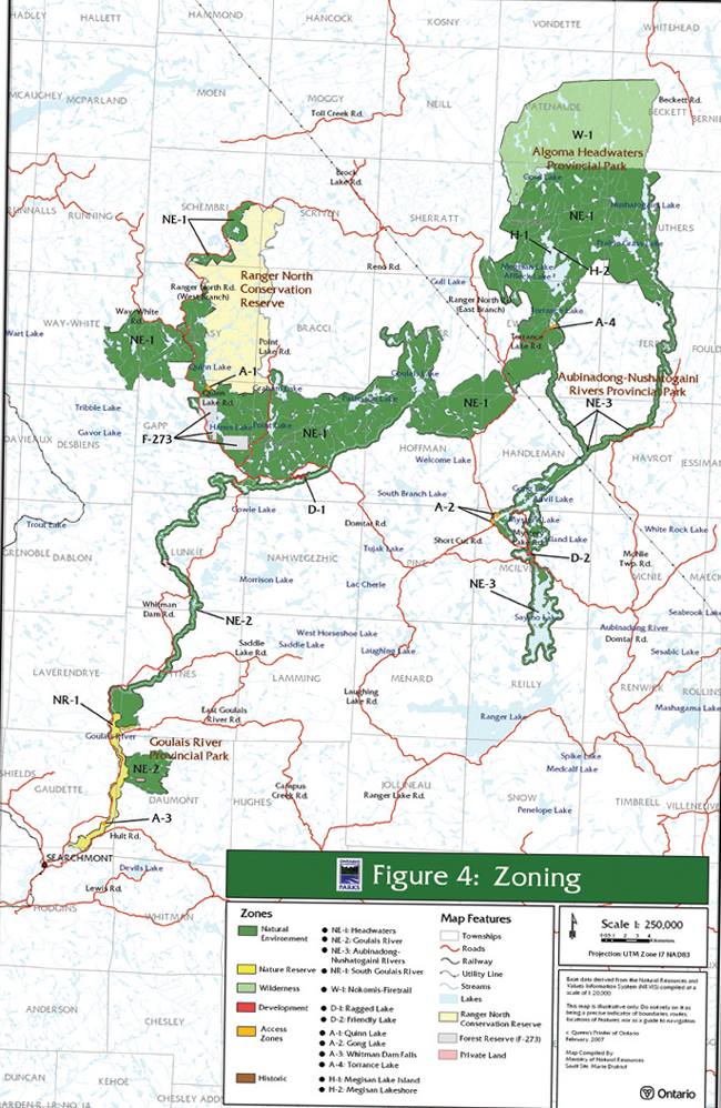
6.0 Park Zoning
Zoning only applies to the provincial parks within the signature site. The intent of zoning is to allocate park lands and waters to their most appropriate use, based on their protection requirements and potential for recreation. The concept of zoning during planning recognizes that each provincial park possesses a unique combination of features, resources and potential experiences. Provincial parks are zoned according to Ontario provincial parks planning and management policies.
Zoning will not be applied to the Ranger North Conservation Reserve. Enhanced protection of features and values within the reserve will therefore be achieved through other avenues, primarily by means of existing legislation and policy for conservation reserves. In situations where existing land uses conflict with the protection of significant values, or when new activities are proposed, a “test of compatibility” will be applied (MNR, 1997).
6.1 Zoning Policies
Zoning, as part of planning for the site’s provincial parks, allows for certain distinct portions of the site to be managed differently from other areas. This is based on the reality that visitors do not use all resources in the same way and that all activities are not carried out everywhere, nor should they be. For example, an area with rare or sensitive vegetation or with a threatened or endangered species would be zoned as a nature reserve, a designation which restricts use to very low-impact activities, thus affording that site the highest level of protection.
There are six types of zones that can be delineated in the planning of provincial parks. These are:
- natural environment
- wilderness
- nature reserve
- access
- development
- historical
When new information becomes available through future inventories or planning, or if there are significant demonstrated conflicts as a result of specific land uses, then enhanced protection of heritage values may be considered. This may be carried out through a change in zoning or other amendments to the plan. Zoning for provincial parks within the Algoma Headwaters Signature Site is shown in Figure 4.
6.1.1 Natural Environment Zones
Natural environment (NE) zones include natural, cultural and aesthetic surroundings in which a minimum of development is required to support low-intensity recreational activities. Development in natural environment zones is limited to backcountry campsites, portages, trails, signs necessary to identify routes, and other minimal facilities that support low-intensity recreational use.
Hunting and trapping will continue within all natural environment zones of the signature site’s provincial parks.
Use of motorboats is permitted throughout the natural environment zones in the provincial parks of Algoma Headwaters Signature Site. The one exception is at the northern inlets of Goulais Lake, where public motorboat access is prohibited in order to protect commercial tourism values.
Public vehicle travel will be permitted within the natural environment zones on those designated roads and routes listed in Appendix C. An agreement between Ontario Parks, MNR and the Sustainable Forest Licensee provides direction on the continued use of forest access roads by the forest industry (Section 8.1. and Appendix C). Abandoned roads and/or trails will be left to naturally regenerate, and vehicular travel is not permitted.
ATVs and snowmobiles are permitted only on designated routes (Table 1). Only snowmobiles are permitted to travel on the designated Ontario Federation of Snowmobile Clubs (OFSC) snowmobile trail. All sections of the OFSC snowmobile trail that are located within the Algoma Headwaters Signature Site in the vicinity of the Whitman Dam Road and Point Lake Road are contained within the Natural Environment zone. (The other two zones where ATVs and snowmobiles are permitted are on designated roads within Access and Development zones.)
The majority of the area of the three provincial parks is designated as natural environment zones. The Ranger North Conservation Reserve is not zoned. Based on geographic and management similarities, three natural environment zones are designated within the signature site’s provincial parks (Figure 4).
These zones are:
NE–1: Algoma Headwaters (34,100 ha)
This is a somewhat remote area with minimal road access, and encompasses over half of the area of the provincial parks. This zone includes the largest number of backcountry campsites in the signature site. As such, management implementation will consist of minimal facilities, such as necessary signs, portages, campsites with designated fire pits and backcountry privies. However, to enhance backcountry use, the establishment of small, all-season, roofed accommodations (such as yurts) may be considered. These could provide opportunities for canoe-in use, hut-to-hut hiking, and cross-country ski touring.
Hike-in and/or canoe-in campsites, as well as a new hiking trail, may be considered in various locations throughout this zone (e.g. Moon– Simms Lake, and the Eileen – Coppens Lakes – Domtar Rock Barrens areas, located off the Domtar Road).
NE–2: Goulais Rivers (4,160 ha)
This NE zone includes most of Goulais River Provincial Park. Use of this scenic canoe route and its dispersed backcountry campsites will continue in this zone. Signage and backcountry privies would be phased in during implementation of this plan.
The Whitman Dam Road is a primary forest access road that was developed several decades prior to the establishment of the signature site. The road meanders in and out of the Goulais River Provincial Park with approximately 14.5 kilometres within Goulais River Provincial Park and within this NE zone. The southern portion of this zone is adjacent to the Nature Reserve zone NR-1: South Goulais River Nature Reserve Zone (Section 6.1.3.) There are significant ecological values associated with this area and the adjacent NR-1 Zone. Thus, any road improvements in this location must be carefully planned, and will be monitored and inspected by MNR / Ontario Parks.
Within a section of the Whitman Dam Road (between kilometre-12 and kilometre-14, in the vicinity of the Goulais Falls), there are concerns regarding public safety, on-going road maintenance, and sensitive park values. It is therefore recommended that, over time, MNR will work with the forest industry and other stakeholders to assess and possibly relocate approximately two kilometres of this road to outside the park boundary. This project would adhere to the requirements of the Environmental Assessment Act.
Other sections of this road may be considered for relocation in the future.
Park users should exercise caution on the southern section of the Whitman Dam Road, due to the significant ecological values in this area (see 6.1.3 – Nature Reserve zone.)
NE–3: Aubinadong–Nushatogaini Rivers (4,930 ha)
This zone covers almost the entire waterway park, which has minimal road access. Use of portages and dispersed backcountry camping will continue in this zone. The Gong Lake Access Zone and the Friendly Lake Development Zone are surrounded by this natural environment zone.
Hike-in and/or canoe-in campsites, as well as a new hiking trail, may be considered within this zone.
6.1.2 Wilderness Zone
Provincial parks can be managed to enhance wilderness experiences through the designation of wilderness (W) zones. These zones designate park lands and waters that are sufficiently large and have the ecological integrity to protect significant natural and cultural features, are suitable for wilderness experiences, and contain an absolute minimum of development.
A significant feature of Algoma Headwaters Provincial Park is its potential to provide a wilderness setting and quality visitor experiences, based on the area’s remoteness. To many backcountry travelers, a wilderness area means a place which contains pristine lands and waters, unmarred by roads, development or human disturbance, where natural processes are allowed to function freely, and where travel is by non- motorized means.
As stated in the Ontario Provincial Park Planning and Management Policies (1992), wilderness zones include areas of backcountry landscapes of appropriate size and integrity which protect significant natural and cultural features and are suitable for wilderness experiences, with an absolute minimum of development.
Given that the northeast sector of Algoma Headwaters Provincial Park is a remote and roadless area containing significant natural heritage and recreational values, the establishment of a wilderness zone is deemed an appropriate designation to protect park values, enhance dispersed remote use, and to further the goal and objectives of the signature site. Thus, the signature site’s wilderness zone is designated, as follows:
W–1: Nokomis–Firetrail Lakes (8,600 ha)
This zone protects a large portion of the most remote area of Algoma Headwaters Provincial Park. There is no development or facilities within this zone. The area’s wilderness characteristics, ecological integrity and remote qualities will be sustained through appropriate management prescriptions.
This wilderness zone encompasses the northeast corner of Algoma Headwaters Provincial Park, and includes the western portion of Beckett Township and much of Patenaude Township. The southern boundary of this wilderness zone follows the northern boundary of the Carton– Carruthers Township line, except at the west end where it extends southward to capture old growth white pine communities in the vicinity of Gord Lake. These white pine forests just west of Gord Lake are among the oldest and best representative samples of old growth white pine in the Algoma region of Ontario.
According to provincial parks policy, new development in a wilderness zone is limited to backcountry campsites, portages, trails and signs necessary for trails and route identification. There will be no land disposition or issuance of land use permits within this zone.
Activities within wilderness zones have certain restrictions. General public access is limited to hike-in and canoe-in access only. While hunting is allowed to continue, motorized travel associated with hunting is not permitted.
There is no motorized travel permitted in the wilderness zone, including aircraft, ATVs, motorboats, and snowmobiles, except for authorized use by registered trappers, bait fish harvesters and bear management operators. Travel by these authorized resource users must comply with the policy direction outlined in this plan (Section 8.1).
Campsites are permitted in wilderness zones, but would consist of minimal facilities, such as necessary signs, designated fire pits, and backcountry privies. However, to enhance backcountry use, Ontario Parks / MNR may establish small, all-season, roofed accommodations such as yurts in this zone. These could provide opportunities for canoe-in use, hut- to-hut hiking, and cross-country ski touring.
Within the overall trail strategy for the protected areas, Ontario Parks will consider the development of new hiking trails and expansion of existing hiking trails in the wilderness zone, with due consideration to maintaining wilderness values.
6.1.3 Nature Reserves Zone
Nature reserve (NR) zones include significant earth and life science features that require a special type of management from those in adjacent zones, with an absolute minimum of development. Some areas are important habitat for significant or uncommon plants and animals, including the presence of rare, threatened, and/or endangered species. Such occurrences elevate the level of protection to the highest category, which is that of nature reserve zone, with the preservation of ecological integrity being a paramount principle in management direction.
Special management prescriptions apply within a nature reserve zone, and motorized travel, aircraft landings, hunting and camping are not permitted. Development within nature reserve zones is limited to day use and non-motorized trails, necessary signs related to natural heritage education, backcountry travel, and temporary facilities for research and management (MNR, 1992).
The Butter Tin Bog is located in Gapp Township within the forest reserve, which will be incorporated into Algoma Headwaters Provincial Park. This bog has significant life science values, particularly because of the uncommon plants that are found there.
The southern portion of Goulais River Provincial Park has extremely significant natural heritage values, as it contains species at risk. Given the significance, sensitivity and vulnerability of the species, the following area is designated as a nature reserve zone:
NR–1: South Goulais River (925 ha)
This zone consists of the most southerly 12 kilometres of Goulais River Provincial Park (which abuts and excludes the 6.5 km. of the Whitman Dam Road which is included in NE–2 zone.) It includes that portion of the area around Whitman Dam Falls, as well as part of the walking trail, that is not included within the access zone (A-4), but is contained within this nature reserve zone.
Due to the ecological values associated within this NR–1 zone, management and maintenance of the more southerly portion of the Whitman Dam Road that is adjacent to this nature reserve zone will be carried out with caution, with the participation of the Sustainable Forest Licence (SFL) holder (refer to Section 6.1.1: NE – 2 Goulais River)
In order to sustain the ecological integrity and protect the species at risk, the East Goulais River Road within the park boundary will be permanently closed, signed and rehabilitated. There will be no allowance for fording the river here with vehicles, such as ATVs, cars or trucks. There are alternate access routes available in order to reach the traditional use areas on the east side of the Goulais River. In addition, there is no camping permitted at the river campsites that were previously unmanaged in this location.
6.1.4 Access Zones
Access (A) zones serve as staging areas where minimum support facilities enable controlled entry to and use of the site. The infrastructure and use in access zones is limited to: roads, visitor control structures, basic day-use facilities, small campgrounds, basic commercial services including outfitting for backcountry users, and orientation, interpretive, education, research and management facilities.
For reasons of public safety, hunting is not permitted in access zones (MNR, 1992). Use of ATVs and snowmobiles are permitted on designated roads within access zones.
There are numerous existing, unmanaged access points and landings within the protected areas. However, some of these currently used locations may be unsafe, are not of adequate size, or are in poor condition. A review of existing and potential access points and landings has been undertaken, with an assessment of use, site characteristics, safety, and potential for improvements relative to minimum park operating standards.
Based on this assessment, four access zones are designated as follows:
A–1: Quinn Lake (6 ha)
This zone is within Algoma Headwaters Provincial Park, but provides access into Ranger North Conservation Reserve. This is a scenic canoeing lake with various connecting waterways, and has excellent recreational potential. A designated parking area with access to backcountry camping opportunities may be considered. It may also be feasible to accommodate campsites on the former MNR airstrip adjacent to the lake.
A–2: Gong Lake (2 ha)
This zone contains two small access and camping areas that are located at the west end of Gong Lake. The zone enables access to and camping on Gong Lake, and provides access to the Aubinadong– Nushatogaini Rivers canoe route. A small number of campsites may be developed at the landing and/or on the lake (section 8.2.3.)
A–3: Whitman Dam Falls (8 ha)
This site provides access to the west shore of the spectacular Whitman Dam Falls. A trail that parallels the Goulais River is a popular route for day users to view these scenic falls. This rugged walking trail extends beyond the access zone into the nature reserve zone. A parking area and trail may be developed. The area within this zone has excellent potential for interpretive trails. Overnight camping is not permitted within the Whitman Dam Falls access zone, however, day-use is encouraged.
A–4: Torrance Lake (2 ha)
The 6.3 kilometre Torrance Lake Road is not maintained, however, this road provides rugged but important access to Torrance Lake and the Aubinadong – Nushatogaini Rivers Provincial Park. It also affords access by water to Megisan Lake and Algoma Headwaters Provincial Park. No camping is permitted at the landing and access point at the south end of Torrance Lake. This access road and parking area requires significant upgrading.
6.1.5 Development Zones
Development zones provide facilities and services for a wide range of day-use and camping activities. This type of zone typically comprises a very small area within provincial parks, and accommodates visitors in developed areas that may offer a moderate level of service and facilities.
Development zones may contain facilities such as: visitor control structures, day-use infrastructure, car campgrounds, administrative offices and basic commercial services; as well as orientation, interpretive, educational, research and management activities. In general, development zones receive more extensive use and allow for more site infrastructure than access zones.
Snowmobiles and ATVs are permitted only on designated roads within development zones. Hunting is not permitted in development zones.
The development zones in Algoma Headwaters Signature Site are delineated as follows:
D–1: Ragged Lake (25 ha)
This is an existing access point and a former MNR work camp (that was previously closed and the site has been rehabilitated). This area could potentially accommodate a boat launch, an Ontario Parks visitor control station and administrative work centre, as well as a small car campground (up to 50 campsites), with associated recreation facilities.
D–2: Friendly Lake (14 ha)
Informal road-accessible camping has occurred for several decades at Friendly Lake. There is significant deterioration of the shoreline and campsites at this location. This development zone may be rehabilitated and upgraded to potentially accommodate up to 30 vehicle-based campsites. A single boat launch facility is recommended to reduce major erosion along the shoreline.
6.1.6 Historical Zones
Historical (H) zones include any significant historical resources requiring management different from that in adjacent zones. A minimum of development allows for low-impact visitor exploration and appreciation, as well as scientific research. Significant archaeological and historical resources that require special protection and management may be designated as historical zones. The priority for historical zones is protection, cultural heritage appreciation and research.
In historical zones, permitted uses are limited to those activities associated with visitor exploration and scientific research. Development in historical zones is limited to minimal interpretive, educational, research and management facilities, as well as trails, portages and necessary signs. No development is proposed for the historical zones within the signature site.
The Algoma Headwaters area was traditionally used by several groups of Aboriginal peoples, including the Missisaugi, Thessalon, Garden River, Batchawana, Michipicoten and Chapleau Ojibway First Nations. Megisan Lake is considered to have high potential for cultural values, since it served as a hub for traditional Aboriginal canoe and winter travel routes, as well as a settlement or homestead area, either on a permanent or seasonal basis.
Within Algoma Headwaters Provincial Park, the following two locations are designated as historical zones:
H–1: North Island in Megisan Lake (3 ha)
Archaeological research suggests that this island was the site of an important Aboriginal encampment. According to Aboriginal elders, Megisan Lake served as a hub for traditional Aboriginal canoe and winter routes. This central settlement on Megisan Lake linked the winter and summer travel routes to other Aboriginal communities. The lake has also been documented as an important spiritual location for First Nations, as well as a plant collection and trapping area.
H–2: Northeast Shore of Megisan Lake (5 ha)
There is archaeological evidence that this location was used by Aboriginal peoples for building canoes and other traditional items. This zone contains culturally modified trees, and the site was documented by a trapper whose trapline was based in the Megisan Lake area in the 1930s.
Ontario Parks will continue to work with the First Nations to identify values of cultural heritage significance within the signature site, and further historic zoning may be implemented accordingly.
7.0 Resource Stewardship Policies
Algoma Headwaters Signature Site will be managed in accordance with Ontario’s policies and legislation for provincial parks and conservation reserves.
The following policies and legislation provide the foundation for resource stewardship within the signature site:
- Ontario Provincial Parks Planning and Management Policies (MNR, 1992) and park policies, procedures and guidelines
- Ontario’s Living Legacy Land Use Strategy (MNR, 1999) and subsequent Ontario’s Living Legacy policy clarification tables for provincial parks and conservation reserves (MNR, 2000)
- Sault Ste. Marie, Chapleau & Blind River District Land Use Guidelines (DLUG) - (MNR, 1983)
- Conservation Reserve Policy (PL 3.03.05, MNR, 1997)
- Provincial Parks Act
- Public Lands Act
- Fish and Wildlife Conservation Act
- Environmental Assessment Act
- Environmental Bill of Rights
Public consultation has also been important in determining what should be considered in resource stewardship. The general public, adjacent landowners, First Nations, Crown land users and others were encouraged to identify their interests during earlier stages of this planning process, and their input has been carefully considered.
The following outlines the resource stewardship policies for the Algoma Headwaters Signature Site, which serve to ensure that the overall objectives for the site are achieved.
7.1 Aboriginal Use
The Algoma Headwaters Signature Site contains traditional Aboriginal travel routes and areas for hunting, trapping and fishing, as well as seasonal gathering and habitation sights. The use of traditional resources by Aboriginal people for subsistence, community and ceremonial purposes will continue within the signature site, with consideration for public safety and conservation objectives.
7.2 Land Management
The management of the signature site is directed towards maintaining the natural landscape and protecting the ecological diversity and integrity of the site. Contingent upon funding, the terrestrial ecosystems and biodiversity of the signature site will continue to be documented through inventories, assessments and research.
Commercial timber harvesting, mining or mineral exploration, and commercial electrical power generation development (e.g. hydroelectric and wind power) are not permitted within the Algoma Headwaters Signature Site. In addition, new energy transmission and communications corridors will be discouraged within the signature site boundary.
Several existing trails branch off from the hydro utility corridor into the signature site. Motorized use of these trails to access the signature site is not permitted, and they will be closed.
The two emergency evacuation sites will remain within Algoma Headwaters Provincial Park and Goulais River Provincial Park. These sites are located at Fyfe Lake in Ewen Township, and at the intersection of the Whitman Dam Road and the Domtar Road in Gapp Township (Figure 3). These sites are situated in road-accessible locations for the safety of forest workers and the public, and for use in helicopter evacuations, forest fires and other emergencies. These emergency evacuation sites must be kept clear, and are not intended for any other use. They are managed by the forest industry under the direction of the Ministry of Natural Resources. A letter of authority will be issued by MNR to the forest industry for the long-term management of these sites.
7.2.1 Adjacent Land Use
Management decisions related to lands adjacent to the Algoma Headwaters Signature Site are based on existing legislation, and strategic direction and policy, such as, but not limited to, the following: the Public Lands Act, Ontario’s Living Legacy Land Use Strategy, the Crown Forest Sustainability Act, the Forest Accord, Environmental Assessment Act, and forest management plans.
The Ministry of Natural Resources considers management needs of signature site-related values on adjacent lands and waters, within the context of the broader ecosystems of the site’s protected areas.
In this way, implementation and planning priorities that are identified in this plan may influence resource management planning that may encompass areas outside the signature site on adjacent landscapes. These may include: an access strategy, a fisheries management plan, a vegetation and fire management plan, and a recreation use strategy. A complete listing of recommended resource management plans appears in Section 9.1.
The designated tourism lakes adjacent to Algoma Headwaters Signature Site, along with the direction in the Crown Land Use Policy Atlas Policy Reports for each of the protected areas, will be considered during forest management and land use planning. This will ensure the protection of values that may be affected by activities carried on outside the protected area boundaries.
7.2.2 Forest Operations
Forest harvesting and renewal activities are not permitted within protected areas. No new forest access roads will be constructed within the signature site (Ontario’s Living Legacy Land Use Strategy, MNR, 1999). The use and maintenance of existing forest access roads by the forest industry will continue within the signature site, as outlined within the tri-partite Roads Agreement between Clergue Forest Management Inc. and/or North Shore Forest Management Inc., MNR and Ontario Parks (MNR, 2002/2001). (Appendix C.)
Realignment of existing forest access roads is permitted, in keeping with standards for safe use of roads, or to enhance park values (MNR, 1999.) Over time, MNR may work with the forest industry to realign a two kilometre section of the Whitman Dam Road to outside the park boundary (refer to Section 6.1.1: NE-2 Goulais River Natural Environment Zone).
Forest operations adjacent to the site will continue to be managed by the Sault Ste. Marie and Chapleau MNR districts, and the respective sustainable forest licence holders. Forest management planning, especially annual work schedules, will be reviewed by Ontario Parks to identify signature site-related values and the necessary forest management practices required to sustain the ecological integrity of protected areas.
7.2.3 Mining and Mineral Exploration
Mineral exploration and mining are not permitted within the signature site. However, policy allows the mining industry to access existing mining lands surrounded by, or adjacent to, the signature site, with appropriate consideration for the protection of values.
7.2.4 Land Disposition
No new sale or disposition of protected lands for the private use of individuals or corporations is permitted within the Algoma Headwaters Signature Site. Existing patented lands may be transferred or sold. However, if any landowner or existing land use permit holder wishes to sell, MNR may consider purchase of patented land and/or site improvements, on a willing-seller / willing-buyer basis.
Should a land use permit for a private recreation camp revert to the Crown, it will no longer be available. If there is a request for a transfer of a private recreation camp on a land use permit, this will be determined on a case-by-case basis.
The transfer of the existing land use permit on Ragged Lake within Gaudry Township will not be permitted, and will revert to the Crown. (This was stated in a letter to the permitee relating to the conditions of this land use permit, dated December 23, 1999).
7.2.5 Commercial Tourism
Existing commercial tourism facilities may continue within the signature site. The existing authorized land use permits may continue to be renewed for commercial tourism purposes, given that the terms, conditions and intent of the permit are being met. Site-specific requirements will be addressed in the conditions of land use permits or other permits that may be issued for commercial tourism operations. Commercial tourism establishments that have tenure by land use permit may be eligible for enhanced tenure, but not for the sale of the land on which they are situated. Transfer of commercial tourism facilities is permitted.
There are currently some vehicular access and travel restrictions to some lakes with commercial facilities for the protection of tourism values (for example, Goulais and Patter(son) Lakes). Should those facilities on patented land cease to be operated as commercial ventures, then the MNR may re-evaluate and change the intent of those access restrictions.
There are a number of significant values that are key attributes of the signature site. These were reviewed as significant in the assessment of whether additional tourism development should be considered, and are as follows:
Values: (natural, cultural and recreational)
- remoteness (in terms of access within the region and province)
- quality visitor experiences
- aesthetics and low levels of development, access and use (as wilderness values)
- self sustaining fisheries with native species diversity and populations
- sensitive biological features, including species at risk and old growth forests
- significant cultural features, including archeological resources, traditional use sites, and built heritage resources.
- existing commercial tourism establishments and Ontario’s Living Legacy planning direction to sustain these operations
- canoe routes
After consideration of the above features and values, especially remoteness and natural heritage values, it has been determined that the existing commercial tourism facilities should be maintained at existing levels within the Algoma Headwaters Signature Site.
As future demand for tourism may warrant, proposals for additional development of facilities, or for the expansion of existing tourism facilities, may be considered. Any decision should ensure that any new facilities would not impact the features, values and ecological integrity associated with the signature site (outlined above) and is in keeping with the requirements of the Environmental Assessment Act.
7.2.6 Waste Management
The Ragged Lake waste disposal site is located within Algoma Headwaters Provincial Park. A Waste Closure Plan has been prepared for this site. The site has been closed and will be rehabilitated, in accordance with the requirements of the Environmental Protection Act.
A conservation philosophy of recycling and “pack- in / pack-out” will be promoted to all park visitors.
7.3 Vegetation Management
Management of vegetation within the Algoma Headwaters Signature Site is directed towards supporting the natural succession of vegetation communities. Commercial timber harvesting is prohibited within the signature site, including the Ranger North Conservation Reserve. The harvesting of non-timber forest products (e.g. Canada yew – Taxus Canadensis) is also not permitted within the signature site.
The Algoma Headwaters Signature Site will be maintained in as natural a state as possible. Insect and disease control measures may be considered, if the identified values are threatened. Infestations of forest insects and diseases may be monitored and assessed. The use of potential control measures would be outlined in the vegetation management plan for the signature site. If control measures are deemed necessary, only biological controls will be used, if possible.
The removal of hazard trees is permitted in all zones, where safety is a concern (e.g. roads and access points). Areas that require rehabilitation (e.g. abandoned roads) may be restored using plant species native to the signature site.
Herbicide applications for vegetation management are discouraged. Brushing and ditching along existing roads may be permitted to improve sight lines and/or traffic flow, dependent on park values. Ontario Parks / MNR District staff will have discussions with Ontario Hydro Services and the Sustainable Forest Licence (SFL) holder regarding management requirements for the control of underbrush and other vegetation along the hydro corridor and roadways, to ensure the protection of the signature site’s values.
7.3.1 Fuelwood Harvesting
Fuelwood permits will not be issued within the provincial parks of the Algoma Headwaters Signature Site. However, within the Ranger North Conservation Reserve, MNR may issue authorization for fuelwood collection, but only for landowners who do not have road access to their property. This would be subject to a review of the impact that such cutting would have on natural heritage values.
7.3.2 Fire Management
The Ministry of Natural Resources recognizes fire as an essential ecosystem process fundamental to maintaining and restoring the ecological integrity of protected areas in the Great Lakes – St. Lawrence and Boreal Forest Regions.
Ontario Parks and the MNR fire program will work together to prepare a statement of fire intent. This document describes the interaction of fire with the land base, identifies preliminary fire management objectives and options, and recommends any further planning efforts. If the statement of fire intent identifies that a fire management plan is appropriate, a fire management plan will be prepared in accordance with the Fire Management Planning Guidelines for Provincial Parks and Conservation Reserves.
Fire management planning will be undertaken by Ontario Parks / MNR in cooperation with MNR’s fire program, to determine approaches to fire management for the signature site. A fire management plan identifies management objectives, protection priorities, the potential use of prescribed fire and/or prescribed burning, and fire response activities. Fire management planning will advance the use of fire to meet ecosystem management objectives, while ensuring appropriate response to forest fires to prevent personal injury, value loss, and social disruption. This plan will examine the historical role of fire in the ecodistrict, and its potential beneficial effects, particularly with regard to forest succession and the rejuvenation of white pine.
Until an approved fire management plan is prepared for Algoma Headwaters Signature Site, fire will be managed as it is on adjacent lands, as directed by the Forest Fire Management Plan for Ontario within the Great Lakes – St. Lawrence fire management zone.
Fires that threaten park visitor safety or park infrastructure will receive full response and sustained action until extinguished. Other fires can be considered for modified response, through consultation between the park superintendent and the fire management supervisor / duty officer.
Wherever feasible, “light on the land” fire suppression techniques, which do not unduly disturb the landscape, will be used when protecting sensitive features. Examples of “light on the land” techniques may include limiting the use of heavy equipment and foam retardant, as well as limiting the number of trees felled during fire response efforts.
Prescribed burning may be used and will be subject to Ministry of Natural Resources policies and guidelines in order to achieve ecosystem management or hazard reduction objectives.
The Statement of Conservation Interest (1999) for the Ranger North Conservation Reserve provides direction for the management of fire within the reserve. It states that forest fire protection will be carried out within the Ranger North Conservation Reserve as on surrounding Crown land, unless alternative direction for the control of fire or the use of fire for management purposes is approved, or until a more detailed local natural resource plan or management plan is prepared. In either case, an amendment to the Ranger North Conservation Reserve Statement of Conservation Interest would be required.
Given that old-growth white and red pine are reliant on ground disturbance, especially fire, it is possible that white and red pine stands may require a separate management regime.
7.4 Wildlife Management
The wildlife within the Algoma Headwaters Signature Site, including Ranger North Conservation Reserve, will be managed on a sustainable basis, in accordance with current policies and legislation (e.g. Fish and Wildlife Conservation Act, Migratory Birds Convention Act). Wildlife management will be directed towards the maintenance and/or enhancement of diverse and healthy populations. Investigations into the management of species at risk within the signature site have been pursued.
Where human-wildlife conflicts arise, animals in the signature site may be trapped and removed directly by, or under the direction of, the Ministry of Natural Resources. This control will be exercised as a last resort, and only when it is essential for the protection of human health and safety, the health of animal species, or the protection of infrastructure.
Opportunities for non-consumptive activities, such as wildlife viewing and hiking, are encouraged within the signature site.
7.4.1 Hunting and Bear Management Areas
The Algoma Headwaters Signature Site lies within Wildlife Management Unit (WMU) 35. Hunting in the signature site for both small and big game will continue to follow the applicable hunting regulations and park zoning policies.
Hunting is permitted to continue within the Algoma Headwaters Signature Site, except where not permitted by zoning. Hunting is not permitted in the nature reserve, development or access zones, which collectively encompass a total area of 976 hectares. Hunting is subject to sustainable wildlife management practices, zoning and management prescriptions, and the applicable Ontario and Federal hunting regulations. Changes outlined in this plan (e.g. motor boat restrictions and aircraft landings) require amendments to regulations under the Fish and Wildlife Conservation Act and the Provincial Parks Act.
Portions of eight authorized bear management areas (BMAs) are contained within the Algoma Headwaters Signature Site. Operations on these existing bear management areas are permitted to continue, except in the portions designated as nature reserve, development and access zones. Areas affected by this plan will be removed from the respective bear management areas.
Short-term land use permits issued for bear hunt camps will no longer be renewed within the provincial parks, due to public safety, resource protection and carrying capacity considerations. This will allow park visitors to utilize the Point Lake area in Gaudry Township at the locations where the short-term permits were once issued to the BMA operator. There are alternate locations for the BMA operator to relocate clients to camping areas outside the parks’ boundaries.
Within the Ranger North Conservation Reserve, short-term land use permits for bear hunt camps may be permitted, but will require authorization from MNR Sault Ste. Marie District.
Transfer of bear management areas may be permitted, where the current operator sells a bear hunting business to another operator, and if the bear management area transfer is approved by MNR. If an operator surrenders a bear management area, or if a bear management area is revoked, reallocation of the bear management area may occur, following applicable screening processes. Applications for the renewal or the transfer of a BMA will be assessed by MNR staff, with due consideration to management objectives, conservation principles and public safety.
Hunting, including bear hunting, is permitted within the wilderness zone in the northeast portion of the signature site, and in all natural environment zones (Figure 4).
7.4.2 Trapping
The Algoma Headwaters Signature Site lies within Wildlife Management Unit (WMU) 35, and all trapping regulations for that unit apply within the signature site. There are portions of 15 active, registered traplines within the Algoma Headwaters Signature Site. Existing trapping will be permitted to continue in all zones of the provincial parks in the signature site, and within the Ranger North Conservation Reserve. Authorized trap cabins associated with registered traplines are also permitted to continue.
Transfer of existing trapping licences and permits may be permitted, subject to review and approval by MNR, and following established allocation procedures. Transfer may occur when either a trapper surrenders a registered trapline, or the trapper privileges are revoked. In addition, trap cabins are considered to be part of the trapline, and would also be considered for transfer with the trapline.
Subject to ecological considerations and implementation planning for the signature site, relocation or modification of trapline trails and cabins may be necessary, and would be evaluated on a case-by-case basis.
Within the signature site, new trap line operations, including trap line cabins and trails, are not permitted. Motorized travel is permitted on existing trapline trails by licensed trappers and individuals accompanying the trapper only.
MNR’s Policy issued by Lands and Waters section pertinent to trapline buildings applies within the signature site.
7.5 Aquatic Ecosystems Management
The abundant aquatic and fisheries resources within the Algoma Headwaters Signature Site are protected under Federal Fisheries Act (1989) and the Fish and Wildlife Conservation Act. The site contains a variety of water bodies, including approximately 175 lakes and 200 streams. Fishing is one of the most common activities carried out by visitors to the signature site, and is governed throughout the site by the Federal Fisheries Act and the pursuant Ontario fishery regulations (SOR/89-93.)
7.5.1 Water Management
The Algoma Headwaters Signature Site contains the headwaters of many rivers including the Goulais, Batchawana, Chippewa, Montreal, Mississagi and Garden rivers, as well as the Nushatogaini and Aubinadong rivers. Thus, the protection that the signature site affords the headwaters of these watersheds may prove beneficial to source water protection.
Baseline information for water quality and quantity may be established, where feasible, for aquatic habitats and for recreational purposes. In high-use areas (e.g. access and camping locations), water quality may be monitored, where feasible, in accordance with provincial standards.
Commercial hydro-electric development is not permitted within the boundaries of the Algoma Headwaters Signature Site.
7.5.2 Saymo and Dyson Lake Dam
The Dyson Lake Dam is situated at the southeast corner of Dyson Lake in Wlasy Township in the western reaches of the Signature Site. This dam is no longer functional and holds back little water. It would pose little potential risk in the event of failure, and will not be replaced.
The Saymo Lake Dam lies at the southern terminus of Aubinadong – Nushatogaini Rivers Provincial Park at the south end of Saymo Lake, and controls water flow from this system into Ranger Lake. The dam is approximately 1.6 metres high and 10.7 metres long. Although still functional, this dam is somewhat dilapidated, and an Emergency Preparedness Plan (2002) is in effect in the event that it fails.
A Dam Safety Assessment Report was prepared for this dam in 2001, and it was recommended that a new rock weir be constructed to replace this aging dam. An overflow weir at this location would still allow for the upstream impoundment of water, thereby maintaining existing water levels in Saymo Lake. This “over-toppable” weir would require no manual operation and very limited maintenance. It would also provide an opportunity for fish migration from Ranger Lake to Saymo Lake. A Class Environmental Assessment Project Plan (2002) was prepared for the Saymo Lake Dam which indicated that a replacement of this dam with a weir was preferred, and this will eventually occur, as priority projects are completed. The replacement of the Saymo Lake Dam will depend on provincial priority and availability of MNR funding.
7.5.3 Fisheries Management
The Algoma Headwaters Signature Site will be managed to protect healthy aquatic ecosystems, including maintaining and/or enhancing a self- sustaining native-species fishery (e.g. brook trout, lake trout and walleye). The “Sault Ste. Marie District Fisheries Management Plan: 1988-2000” (MNR, 1988) identifies strategies for locations within the signature site, and continues to provide direction for the management of fisheries that are now contained within the signature site.
A number of prime lake trout lakes were designated in the Sault Ste. Marie and Chapleau District Land Use Guidelines (DLUG – MNR, 1983), some of which are included in the protected areas within the Algoma Headwaters Signature Site. These designated lake trout lakes include: Gord, Megisan, Saymo, Gong, Goulais, Patter(son), Clove, Prairie Grass, Lance and Ninegee. (Note that this is nota complete listing of lakes with lake trout within the signature site.)
Sport fishing is permitted to continue within the Algoma Headwaters Signature Site, in compliance with relevant regulations.
As specified in the Ontario Fishery Regulations, baitfish restrictions and special seasons apply in certain lakes, including special catch and possession limits. (Current fishing regulations should be consulted, as these are subject to change.)
Fisheries direction specific to the Algoma Headwaters Signature Site includes the following:
- Commercial fishing is not permitted within the signature site.
- Introduction of non-native fish species are not permitted.
- Live baitfish will continue to be restricted, in accordance with the Ontario Fishery Regulations, in an attempt to reduce the risk of accidental introductions. (Note that leeches are considered tobe ‘bait’, and crayfish are considered to be ‘baitfish’, as specified in the Ontario Recreational Fishing Regulations Summary).
- Fish sanctuaries may be designated on selected lakes within the signature site, if deemed necessary to protect fisheries values.
- Fish stocking would provide for the designation of a “put and take” fishery on lakes that are road accessible. Such management options may be considered during implementation planning, but would depend on the availability of fisheries information, including creel census and lake survey data.
- Fly-fishing is the only method of angling permitted within the three-kilometre section of the East Goulais River, as recognized in the Ontario Fisheries Regulations, within the boundaries of Goulais River Provincial Park. The designation of additional “fly-fishing only” areas may be considered in the future within the signature site.
- Existing authorized commercial bait harvesting licences are permitted to continue in the provincial parks, subject to conditions specified on the licence. No new bait harvesting licences are permitted in any provincial park in the signature site. However, active licences may be transferred where bait harvesting is an established permitted use. Within the Ranger North Conservation Reserve, bait harvesting may be permitted. There are nine bait harvest areas, or portions thereof, within Algoma Headwaters Signature Site.
A Fisheries Management Plan may be prepared by Ontario Parks / MNR for the Algoma Headwaters Signature Site, which would include Aboriginal dialogue and public consultation. The restoration of signature site fisheries and aquatic habitats may be undertaken, where appropriate. Any decisions made regarding fisheries management in the signature site’s parks (e.g. stocking, change to seasons, sanctuaries, and ice fishing restrictions) would be done in conjunction with MNR District staff, and will be consistent with all applicable fisheries management plans and strategies.
7.6 Culteral Heritage Resources
The management of cultural heritage resources within the Algoma Headwaters Signature Site will be directed toward protection, as well as the provision of heritage appreciation and research opportunities. Protecting cultural heritage resources is a high priority and can be addressed through zoning, legislation and public education.
Implementation of measures to identify and protect sacred Aboriginal sites and traditions is also a priority. First Nation communities have been invited to identify traditional heritage uses and sites, and to explore approaches with the Ministry of Natural Resources to protect Aboriginal heritage. The sensitivity of this information will be respected. Ontario Parks will continue to work with the Ministry of Culture and with Aboriginal communities to inventory, protect and maintain archaeological and historic sites within Algoma Headwaters Signature Site. Further archaeological investigation will be pursued in an attempt to identify additional historical sites, including fur trade, logging and mining sites.
Periodic inspection of all identified significant sites will be carried out by MNR staff, with protective controls established as required. The removal of artifacts, or the disturbance or destruction of historical features, is illegal and prohibited (as cited in the Ontario Heritage Act, Provincial Parks Act, and Public Lands Act.)
Cultural heritage assessments may be undertaken prior to any development that is identified within this plan, in accordance with the appropriate Environmental Assessment legislation. As significant cultural heritage resources are identified, it may be necessary to amend this signature site management plan through zoning changes and other means, in order to ensure their protection.
8.0 Operations and Recreation Management Policies
This management plan describes the policies related to resource management, client services and park facilities in the Algoma Headwaters Signature Site. The focus of this plan is on the protection of the natural environment, waterway environment, and existing recreational opportunities. Most traditional uses, such as fishing, boating, and canoeing, may continue. Hunting will be permitted to continue, except in nature reserve, access and development zones.
Recreation management will support and accommodate the activities associated with existing tourism operations within the signature site. Authorized resource users, such as tourist outfitters, registered trappers, bait harvesters and bear management operators, may continue within the signature site. Traditional car camping will be discouraged in locations where signature site values are being compromised. Once an operational plan has been prepared, overnight camping opportunities may be provided at Ragged and Friendly Lake (refer to Section 6.1.5.)
The following are general principles that could assist in developing an operations and recreational management program:
- The program could be developed gradually with public and stakeholder involvement
- Aboriginal communities would be encouraged to participate
- Park facilities would be kept to a minimum
- The use of partnerships would be encouraged
- Strategies would be developed to integrate all uses to ensure that the objective of ecological integrity and protection is not compromised
- Consideration of remote tourism values would be recognized
- Site planning and development of facilities required to support backcountry and car camping opportunities are necessary prior to implementation
- This program would adhere to current park policies, the Environmental Assessment Act and other pertinent requirements
The operating plan for the signature site would be prepared in keeping with the principles identified above. It would also recognize levels of current and traditional users within and around the signature site.
The operating plan would also provide staff with the necessary information required for daily operation of the signature site. The operating plan will include such topics as budget, staffing, occupational health and safety, maintenance schedules, enforcement and emergency services. The provisions of the operating plan would be consistent with appropriate MNR and provincial park operating standards, and would be reviewed and updated, as required.
The following summarizes the operational policies regarding access, recreation management, natural heritage education, and research.
8.1 Access and Motorized Travel
Access and motorized travel have been significant planning topics for the Algoma Headwaters Signature Site. The area contains a network of primary and secondary forest access roads, many of which date back to the mid-1900s and pre-date the designation of the protected areas. Over the decades, the area has received considerable use, much of it by sportsmen and recreationists who are primarily from the local area. The forest access roads are still used today by the forest industry, and the presence of large logging trucks on those roads is a safety concern for users of the signature site.
The following direction regarding access serves to balance recreational use of the site, while protecting natural, cultural and recreational values. It is the intent of this direction to manage the general distribution of visitors within the signature site, while maintaining the ecological integrity of the protected areas.
8.1.1 Access Roads
Access to and within the protected areas of the Algoma Headwaters Signature Site is limited to the use of “designated” roads, as shown in Appendix C and Table 1C. New roads or trails for motorized travel are not permitted within the provincial parks. Abandoned roads and/or trails not identified in Appendix C will be left to naturally regenerate, and vehicular travel is not permitted. All roads, or portions thereof, located within the three provincial parks are governed by the Highway Traffic Act, as well as the Provincial Parks Act.
Within the conservation reserve, proposals for new trails for motorized travel may be considered, if they are determined to be appropriate and are in keeping with protected area values. Roads within the conservation reserve are governed under the Public Lands Act.
The abandoned bridge on the Dyson Lake Road that crosses the Quinn River in Wlasy Township may be removed.
The development of an access strategy will be a priority, and will detail all aspects of access to, and within, the signature site’s provincial parks and conservation reserve. This strategy would address safety concerns for the public use of forest access roads that are currently being maintained and used by the forest industry. Users of roads in the vicinity of the signature site include Ontario Parks visitors, forest industry users, and the general public.
The primary access to and within the Algoma Headwaters Signature Site requires the use of existing roads, as specified in the following sections. Secondary access by air and boat is also addressed here.
8.1.2 Forest Access Roads
The Algoma Headwaters Signature Site contains various primary forest access roads, including the Whitman Dam Road, the Domtar Road, and the Ranger North (east and west branches) Road. Use of these roads by the forest industry will continue. This is consistent with direction in Ontario’s Living Legacy Land Use Strategy (1999), which states: “Existing forestry access roads that are essential for continued access beyond the area for forest management… will continue to be available for access, provided alternative access does not exist and road relocation is not feasible. Continued use will include maintenance and may also include future upgrading.“
An agreement between MNR Sault Ste. Marie District, Ontario Parks, and the forest industry states that the existing forest access roads within and adjacent to the signature site (Appendix C) will continue to be used and maintained by the forest industry. The forest industry will use existing staging areas on forest access roads, with conditions for use and/or restrictions to be determined during implementation planning.
Minor road realignment of forest access roads may occur, if necessary, for upgrading, safety and maintenance purposes, provided park values are protected. Due to the ecological values associated with Nature Reserve zone (SFL) holder. This area must be monitored and inspected by MNR, prior to any road improvements.
The roads agreement between Ontario Parks, Sault Ste Marie District MNR, and the sustainable forest licence holders (Clergue Forest Management Inc. and North Shore Forest Inc.), provide guidelines for the forest industry to use and maintain forest access roads through and adjacent to the Algoma Headwaters Signature Site. These agreements recognize the forest industry’s ongoing and future need to access and maintain specific, identified roads. Refer to Appendix C Tables 1A and 1B for a complete listing of Forest Access Roads.
The requirement and use strategies for these existing roads will be determined through the forest management planning process, with input from Ontario Parks and MNR districts. Road use strategies will be implemented through the Algoma Forest and the North Shore Forest management planning annual work schedules.
Use of motor vehicles, snowmobiles and ATVs is currently permitted on the Point Lake Road, which was originally built to provide forest access into Crown allocations. However, for safety reasons, once forest industry returns to upgrade and commence use of the Point Lake Road, the Ontario Federation of Snowmobile Clubs (OFSC) trail will be re-routed to the Ranger North-West Road. MNR, the OFSC and the Sustainable Forest Licence holder will work closely together to ensure continued access through the signature site.
All aggregate extraction operations within the Algoma Headwaters Signature Site should be in compliance with: the Provincial Parks Act and regulations, the Aggregate Resources Act and regulations, and the Environmental Assessment Act.
8.1.3 Recreational Access Roads
All roads listed in Table 1 (Designated Snowmobile & ATV Routes, page 38) and in the tables of Appendix C are frequently traveled by the public in order to engage in recreational activities within the signature site. Use of these roads by motorized vehicles is permitted to continue.
Public use is permitted on the identified roads and forest access roads, as shown on Figure 3. Due to the presence of logging trucks and other forestry vehicles on forest access roads, the safe public use of these roads is of concern and will be addressed through various approaches. These may include, but are not limited to, cautions cited in protected area literature, and the posting of appropriate signage on the Whitman Dam Road and on other forest access roads.
Significant upgrades to the Torrance Lake Road will be required for public use and to provide safe access.
No new roads for motorized use will be approved or constructed within the signature site.
8.1.4 Trails
With the exception of the Ontario Federation of Snowmobile Clubs (OFSC) snowmobile trail, there are no “authorized” trails that are designated for motorized travel within the signature site. However, motorized travel is permitted on existing trapline trails by licensed trappers and individuals accompanying the trapper, by bait fish harvesters, and by BMA operators, while accessing their respective areas. Realignment of any trails may be necessary and are subject to approval by MNR. Public motorized use of these trails is not permitted.
No new trails for motorized travel will be constructed within the signature site. Motorized travel is not permitted on the signature site’s hiking trails. (Hiking trails are discussed in Section 8.2.1, and use of the OFSC snowmobile trail is outlined in Section 8.1.7.)
New hiking trails may be developed, in accordance with the listing of proposed trails provided in this plan (page 46, Table 2). Further detailed trail planning would be included in a recreational use strategy, which would identify and describe the types and standards for trails, and for periodic monitoring of trail conditions within the site.
8.1.5 Closed Roads
To ensure the sustainability of the protected areas’ values, the following roads (Figure 3) in Algoma Headwaters Signature Site will continue to be closed:
- Megisan Lake Road
- Eileen – Coppens Lakes Roads
- Dead Lake Road
Before the signature site was established, these road closures were in place under the authority of the Public Lands Act. However, with the regulation of the three provincial parks within the signature site in 2003, the authority for road closures within the provincial parks is now under the Provincial Parks Act.
In the future, further road closures may be necessary to protect ecologically sensitive values.
8.1.6 Use of Motorized Recreational Vehicles
Travel by snowmobiles and ATVs for recreational purposes on “authorized” roads and trails is permitted within new protected areas (Ontario’s Living Legacy Land Use Strategy, MNR 1999). In keeping with OFSC policy, ATVs are not permitted on the OFSC snowmobile trail.
The “authorized” roads that are designated for travel by motorized recreational vehicles within the signature site are listed in Table 1 and Appendix C. There are no “authorized” trails within the signature site other than the OFSC snowmobile trail. Travel in areas other than on those ‘designated’ snowmobile and ATV routes (Table 1 and Appendix C) is strictly prohibited, and is in contravention of the Provincial Parks Act and regulations.
8.1.7 Use of Motorboats
Motorboats are permitted throughout most of Algoma Headwaters Signature Site, with a few restrictions. Motorboats are not permitted in the wilderness zone (section 6.1.2) and in the nature reserve zone (section 6.1.3) within the signature site.
The use of motorboats is permitted throughout the natural environment zones in the provincial parks of Algoma Headwaters Signature Site. The one exception is at the northern inlets of Goulais Lake, where public motorboat access is prohibited in order to protect commercial tourism values. Motorboat use is permitted within the Ranger North Conservation Reserve.
8.1.8 Snowmobile Use in Provincial Parks within the Signature Site
The OFSC Trail is situated in the vicinity of the Goulais River Provincial Park and the Point Lake Road (Figure 3). A valid OFSC trail permit is required for all snowmobile trail riders on the OFSC trail within the signature site.
Motorized snow vehicle travel is only permitted on designated roads and secondary routes, as well as on the OFSC trail, and is not permitted elsewhere. New roads or trails for snowmobile use will not be permitted. The secondary routes are not maintained and users of these routes do so at their own risk.
The following table (Table 1) identifies those designated roads and secondary routes where snowmobiles are permitted.
Table 1: Designated Snowmobile & ATV Routes*
| Main Roads | Secondary Routes |
|---|---|
| Whitman Dam Road | From Perry Creek to Domtar Road. |
| Point Lake Road | From Domtar Road to northern boundary of Algoma Headwaters Park to Graham Lake |
| Point Lake Road | Off Point Lake Rd. to Chubb Lake Off Point Lake Rd. to Point Lake Off Point Lake Rd. to Alice Lake |
| Domtar Road | Off Domtar Rd. to Turtle Lake |
| Domtar Road | Off Domtar Rd. to Moon Lake |
| Domtar Road | Off Domtar Rd. to Gaudry T. Lake # 22 |
| Domtar Road | Off Domtar Rd. to Gaudry T. Lake # 31 |
| Ragged Lake Road | From Domtar Rd. to Ragged Lake |
| Quinn Lake Road | From Domtar Road to Quinn Lake |
| Domtar Roa | From Domtar Rd. to Witchdoctor Lake |
| Road to Gong Lake Access | From Ranger North East Road to Gong Lake |
| Mystery Lake Road | From Ranger North East Road to Mystery Lake |
| Mystery Lake Road | From Ranger North East Road to Island Lake |
| Torrance Lake Road | From Ranger North East Road to Torrance Lake |
| Domtar Road | From Hanes Lake to Butter Tin Lake |
| Ranger North West Road | From Quinn Lake to north of Quinn River |
| Domtar Road | From Whitman Dam Road to Witchdoctor Lake |
| Domtar Rd. | Across park boundary to Saymo Lake |
| Ranger North East Road | Across park boundary to Friendly Lake |
| Domtar Rd. | Across park boundary to Gong Lake |
| Ranger North East Road | Across park boundary between Hound and Fyfe Lakes |
Note: Snowmobiles & ATVs are permitted only on roads and secondary routes listed above.
* Refer to Figure 3 for map locations cited above.
8.1.9 ATV Use in Provinicial Parks within the Signature Site
Within the provincial parks, ATVs are permitted only on designated roads (i.e. those designated roads listed in Table 1 and Appendix C). New roads or trails for ATV use are not permitted, and this will be enforced.
Under the Federal Fisheries Act, no one can harm fish habitat, or deposit harmful substances into water containing fish. This includes the silt or soil that may be stirred up by ATVs traveling in and around waterways. Other values can also be compromised with off-road ATV travel. Therefore, recreational users of ATVs must travel on the designated roadways only. Travel off of these designated roads by ATVs within the signature site is strictly prohibited.
8.1.10 Use of Snowmobiles and ATVs in the Ranger North Conservation Reserve
In the Ranger North Conservation Reserve, no authorized trails for snowmobiles or ATVs have been identified. In general, off-trail use of snowmobiles and ATVs in this conservation reserve is not permitted. The exception is for licensed trappers to access their traplines and for licensed bait operators to conduct bait harvest activities. ATV use for bear management operations may continue on roads and existing trails within the Ranger North Conservation Reserve. Off-trail use of ATVs and snowmobiles is also permitted for the direct retrieval of big game by hunters.
In all cases, off-trail use is only permitted in the Ranger North Conservation Reserve, provided that the protection of the site’s values are not compromised. Should the impact of off-road ATV and snowmobile use degrade the landscape, the Ministry of Natural Resources will re-evaluate these permitted uses and determine a new direction.
8.1.11 Unauthorized Vehicles
Unlicensed, off-road vehicles (such as dirt bikes, Argos, dune buggies) are not permitted anywhere within the Algoma Headwaters Signature Site. “Tracked” ATVs (even if licensed) are also not authorized for use within the site.
8.1.12 Aircraft Landing
The landing of aircraft is permitted within Algoma Headwaters Signature Site, except on water bodies that are contained within the wilderness and nature reserve zones (Sections 6.1.2 and 6.1.3).
Permits for aircraft landing are required for all water bodies within the signature site’s provincial parks, and will be issued annually by Ontario Parks. Aircraft landings are currently permitted within the Ranger North Conservation Reserve without an aircraft landing permit.
8.2 Recreation Management
The initial task of the recreation management program will be to determine the existing levels of use, and to evaluate and quantify the carrying capacity of the protected areas. Surveys will be required to substantiate decisions being made on the landscape that may affect traditional use areas. The survey will collect important data on the type and density of the variety of uses in specific areas, including user origins, user likes and dislikes, party size, length of stay, main entry locations, and travel patterns. In addition, existing camping and back country campsites will be monitored. Information will continue to be gathered on the condition of existing camping sites and resource impacts will be monitored. Based on existing data collected and future survey results, the carrying capacity and space standards will be evaluated to determine the carrying capacity for use. This process will be carried out in the context of implementing the Algoma Headwaters Signature Site Management Plan.
Recreation management will provide for a variety of recreational opportunities, while attempting to minimize any negative environmental impacts that may occur to protected areas’ natural and cultural values. Low intensity recreation that is compatible with signature site values is encouraged.
There are two private properties in Lunkie Township, both of which abut the boundary of Goulais River Provincial Park. A portage on the Goulais River crosses both of these patented properties, and its continued use requires an agreement between MNR and the property owner.
It will be acceptable for the land owner in Daumont Township within the Goulais River Provincial Park to access the land-locked property by means of a two-track road, for the purpose of recreational access only. In the event that the land owner wishes to harvest his private parcel of land, the MNR recommendation of access to the property will be a winter harvest, where the use of a winter road will be encouraged. It will be necessary to ensure that park values are protected, and the MNR will approve the route chosen to access this property. Fording of the Goulais River to access this property will not be permitted.
8.2.1 Canoe Routes and Hiking Trails
There are a number of canoe routes within the Algoma Headwaters Signature Site offering a variety of paddling experiences, including creeks, rivers, and large and small lakes. The two major canoe routes are the Goulais River, and the Aubinadong – Nushatogaini River systems (the latter is often referred to as the ‘Ranger North Canoe Loop.’) Several other canoe routes found within the signature site are in the vicinity of Megisan, Gong, Quinn and Hanes Lakes.
The Goulais River canoe route is the most popular and readily accessible canoe route in the signature site. The total length of the river is 117 kilometres, of which the 67 kilometre stretch located north of Searchmont is protected within Goulais River Provincial Park. The navigability of the Goulais River is extremely variable, as it is highly influenced by precipitation and season. In general, the river has a gentle gradient, but it does contain some technical whitewater sections, in particular, the stretch located north of the Saddle Lake bridge.
There are a few existing hiking trails within the Algoma Headwaters Signature Site, most of which are short and have been developed by tourist outfitters or through traditional use. Use of these existing hiking trails is permitted to continue, but only for non-motorized travel. Expansion and/or enhancement of these existing trails may be permitted, through case-by-case consideration within the pending trail plan.
A recreational trail plan (as part of a recreational use strategy) may be prepared to identify new hiking trails that will be developed. The plan will also provide an assessment of all existing trails (e.g., hiking trails, canoe routes) in the protected areas, and how they should be managed. These would include numerous portage trails, walking paths to view Whitman Dam Falls and Goulais Falls, and some nature trails of not more than two kilometres in length which have been developed on remote tourism lakes. There are also indistinct trails used to access old growth pine stands in the Ranger North Conservation Reserve. These trails may be upgraded for enhanced walking / hiking access.
The wilderness zone, in the northeast sector of Algoma Headwaters Provincial Park, is limited to hike-in and canoe-in access only. Within the overall trail strategy for the protected areas, the development of new hiking trails and expansion of existing hiking trails may be considered, with due consideration to maintaining wilderness values.
8.2.2 Day Use
There has been ongoing day-use of the area now established as Algoma Headwaters Signature Site for several decades, and this use will continue to be encouraged. Popular day-use activities in the signature site include fishing, boating, hunting, canoeing, hiking and wildlife viewing. Snowmobiles and ATVs are permitted on designated roads and secondary routes only (Sections 8.1.8 and 8.1.9).
8.2.3 Camping
The intent of park planning policies is to establish acceptable levels of visitor use, wherein park values are not compromised, and high quality recreation activities are maintained. Controls on overnight use may be required to protect the park environment and ensure a high quality recreational experience.
Small campgrounds for overnight car camping may be developed at Ragged Lake (D-1) and Friendly Lake (D-2). Additional remote backcountry drive-in campsites may be developed at other locations, as demand warrants.
Besides car camping areas accessible by road, the signature site also has interior or remote campsites, which can be accessed by air, boat or on foot. Numerous interior campsites have been informally established throughout the signature site by recreationists over the years. Use of these interior campsites may continue, subject to an assessment to determine if values are threatened. Some campsites may be closed and/or rehabilitated in order to meet Ontario Parks’ standards for interior sites.
Additional campsites may also be developed. These interior campsite locations would be designated in the recreation use strategy (which would be prepared during implementation planning), with the objective of providing further backcountry camping opportunities throughout the protected areas.
Roofed accommodation provided by MNR, such as yurts, may be considered within development (D-1 & D-2), natural environment (NE-1 & NE-2) and wilderness (W-1) zones.
While camping is permitted within the Ranger North Conservation Reserve, this activity will be monitored to ensure that it is consistent with the values of this protected area (Ranger North Conservation Reserve: Statement of Conservation Interest, MNR, 1999). Should environmental impacts occur as a result of this use, then the policies regarding camping within the conservation reserve will be re-evaluated.
8.2.4 Boat Caches
Boat caches for both private recreational use and commercial tourism purposes will be permitted within the Algoma Headwaters Signature Site. A boat cache strategy will be prepared (as part of a recreational use strategy) for protected areas in the signature site, in order to identify locations that are suitable for boat caches. Private boat caches will not be permitted on lakes with commercial tourism establishments. Fees for boat caches may be implemented.
Persons wanting to cache a boat(s) within the signature site would submit their request to MNR, including rationale, number of boats and location. Upon review of the request, approval may be given for the issuance of a boat cache authorization decal. Within the site’s provincial parks, authorization would be given by Ontario Parks, and within Ranger North Conservation Reserve, approvals would be issued by the Sault Ste. Marie District. Any boats and related equipment found within the signature site without an affixed authorized boat cache decal may be removed.
8.3 Natural Heritage Education
There are opportunities to enhance public awareness of the signature site through signage, education and self-use natural heritage education. Information, education, and interpretation are key to enhancing visitor awareness about the site’s natural and cultural features, facilities and services.
Themes for natural heritage education associated with the signature site include, but are not limited to:
- Old growth forests, especially white and red pine
- Headwaters of major rivers (e.g. Goulais, Batchawana, Mississagi)
- Significant glacial features
- Forest fire on the landscape
- Cultural heritage features and values (e.g. traditional travel methods, Aboriginal place names and meanings, traditional practices including ceremonies, etc.)
- Wildlife, bird, fish populations and plant species
- Species at risk – status for vulnerable (special concern), threatened and endangered species and their habitat needs in Ontario
A Natural Heritage Education Strategy will be prepared, and would identify self-use and self- guided opportunities for heritage appreciation of the signature site’s protected areas. It will include the development of signs, interpretive materials and trails, and self-use facilities. As part of an overall signature site trail plan, potential sites for self- guided trails will be identified, and may include the following locations:
- Eileen and Coppens Lakes
- Moon Lake
- Domtar Road Rock Barrens
- Scenic falls – Whitman Dam Falls and Goulais Falls
- Butter Tin Bog
- Traditional canoe routes
- Other lakes and waterways (to be determined)
The priority for development of interpretive and promotional material (e.g. signs, displays and brochures) will be determined through natural heritage education planning.
8.4 Research and Monitoring
Within Algoma Headwaters Signature Site, scientific research and monitoring by qualified groups and individuals is encouraged which would contribute to the knowledge, inventory and identification of the site’s natural, cultural and recreational features and values. MNR research and information requirements relate directly to the mandate, goals and objectives of the signature site’s protected areas. The focus on ecological integrity will remain a priority in research and monitoring within the signature site area. This would be in accordance with protected areas policies and procedures, as appropriate.
Research and monitoring provides a better understanding of the natural, cultural and recreational features and values of the area, which will in turn advance the protection, planning, and management of the protected areas. The pursuit of research and monitoring is required to address the wide range of environmental, social and economic factors that are necessary to administer an ecologically sustainable system of protected areas. It is important that research activities assess the quality of outdoor recreational experiences and visitor satisfaction.
Partnerships may be established with universities, college, industry, government and non-government organizations, First Nations, and other associations to advance applicable research. Technical support and assistance would be provided, where possible, by MNR staff. Research projects to date, within the signature site relate to species at risk and old growth white and red pine, with the assistance of partnerships from academic institutions. These studies are important in meeting the objectives of protection and perpetuation of significant life science values within the protected areas.
All research and monitoring programs within the signature site’s parks must be compatible with the goal, objectives and zoning prescriptions of the associated park. Research projects require prior approval and must be conducted in accordance with Ontario Parks policy. Research must also meet all other applicable provincial requirements, and will be monitored by the MNR / Ontario Parks. Within the Ranger North Conservation Reserve, non-destructive scientific research, baseline studies and monitoring, and outdoor education will be encouraged. Research activities within the conservation reserve will require approval by Sault Ste. Marie District MNR.
Any First Nation cultural heritage research would include the involvement of local Aboriginal communities and would require approval and monitoring by the Ministry of Culture. Should additional significant cultural features or resources be discovered and/or confirmed, this plan would be amended according to policy direction. (Note that major amendments require public consultation.) This would ensure that appropriate protection would be provided through the appropriate zoning and revision of plan policies.
Research and monitoring needs within the Algoma Headwaters Signature Site are diverse, and include the natural, cultural and recreational aspects of the site. Specific research projects which may be undertaken are as follows:
- Field inventory of cultural heritage values
- Species at risk – habitat evaluation and population dynamics
- Old growth white and red pine, sugar maple and yellow birch and black spruce ecosystems (inventory, structure, function, bio-diversity, regeneration and succession, etc.)
- Effects of fire suppression on old growth forests
- Fisheries studies – lake assessments on stocked lakes and lake trout lakes
- Survey of visitation and use of protected areas
- Socio-economic study – for signature site and old growth ecosystems
Research and monitoring priorities that have been determined to date in the development of this plan are listed in Table 2: Operations Implementation, which appears in Section 9.2.
All research and monitoring programs require the approval of Ontario Parks / MNR, and are subject to policy and related legislation.
9.0 Development Policies
All development within the signature site will be in compliance with the requirements of the Environmental Assessment Act (1990), the Class EA for MNR Provincial Parks and Conservation Reserves (2004), and other relevant policies and legislation. There may be opportunities and benefits associated with outside assistance and funding by partners.
The Roads Agreement, (between MNR and Clergue Forest Management Inc., 2002; and North Shore Forest Inc., 2001) specifies guidelines for the forest industry to use and maintain forest access roads through and adjacent to the Algoma Headwaters Signature Site (Appendix C). Ontario Parks / MNR will jointly approve all road maintenance prior to implementation.
This plan identifies priorities for new development, which would be implemented through business and work program planning, and would be consistent with Environmental Assessment Act requirements for provincial parks and conservation reserves. New development would be based on priority, and the availability of human and financial resources. It would be carried out in accordance with approved protected area policies, procedures and guidelines (e.g. site planning for development in provincial parks).
Development is not permitted in the nature reserve and wilderness zones of provincial parks, except for necessary signs, trails and facilities that are consistent with the zoning direction given in this plan.
9.1 Plan Implementation
Implementation of the operations and management of the protected areas of Algoma Headwaters Signature Site will follow the direction contained in this plan. The signature site’s provincial parks and the Ranger North Conservation Reserve are currently governed by different policy and legislation, therefore, the approaches to implementation may vary. MNR Districts and Ontario Parks would work cooperatively, to attempt to address site development in an efficient and effective means. This would include, but would not be limited to, the management of access, visitor distribution, camping, and trail facilities within the various protected areas, according to the needs identified in this management plan.
The implementation of this plan will be consistent with all current legislation and other pertinent policy direction, planning documents and guidelines. These include the following: Environmental Assessment Act, Provincial Parks Act, Public Lands Act, Provincial Parks Planning and Management Policies, Land Use Strategy, and related policy clarification, the Ranger North Statement of Conservation Interest, and the Forest Access Roads Agreement between MNR, Ontario Parks and Clergue Inc., and North Shore Forest Inc. A more complete listing of references can be found in Section 12.0.
However, further planning will be required for full implementation of management and development strategies. This may entail the preparation of various resource management plans, and may encompass areas outside the signature site on adjacent landscapes. These resource plans may include, but are not limited to, the following:
- Access Strategy
- Operating Plan
- Species at Risk Recovery Strategy
- Fisheries Management Plan
- Vegetation and Fire Management Plan
- Site plans for road-accessible and backcountry camping (facility development)
- Recreational Use Strategy (including a Trail Plan and Boat Cache Strategy)
- Natural Heritage Education Strategy
- Visitor Safety Plan
- Marketing Plan
Implementation planning for the signature site may integrate direction for the Ranger North Conservation Reserve, in terms of the following:
- Monitor activities to ensure adherence to management guidelines
- Prepare a fact sheet highlighting the site’s natural and cultural heritage values
- Research and monitoring studies, including a survey of pine recruitment, with appropriate action taken to protect old growth pine values
- Consideration of acquisition of private properties adjacent to the signature site
- Scientific research, including baseline studies and monitoring
- Recreation management needs relative to the signature site trail plan and recreation strategy.
Implementation of Ranger North’s Statement of Conservation Interest and the direction contained in the approved plan will be the shared responsibility of Sault Ste. Marie MNR and Ontario Parks staff. Partnerships may be pursued to address management needs. Should other management and development decisions arise that are not addressed within the Ranger North Conservation Reserve Statement of Conservation Interest, then an amendment to the Statement of Conservation Interest and to this management plan will be required.
9.2 Implementation Phase-in
With the implementation of direction in this management plan, the signature site may become operational, resulting in the provision of services and facilities for public use.
A summary of resource stewardship, operations, and development projects that have been proposed for the signature site are outlined in the following two tables. All projects for the signature site are subject to a sound business case and will require adequate funding. These development activities are prioritized in Implementation Phases 1 and 2 (Tables 2 and 3.) Note that these two phases are not mutually exclusive, and projects may not necessarily be implemented in sequential order.
Table 2: Phase 1–Implementation
| Project | Location | Type | Comments |
|---|---|---|---|
| Closure of Waste Disposal Site | Ragged Lake | Closure, then decommissioning | First stage has occured (2005) |
| Implementation of operations in signature site | Entire signature site | Development of an operating plan and an implementation strategy | Implementation will be prioritized as visitation warrants and funding becomes available. Partnerships will be encouraged. |
| Signage | To be determined in sign plan | Prepare sign plan for park boundaries and visitor safety notices | To meet park operating standards For access management and safety of visitors on forest access roads To post portages and nature reserve zones, etc. |
| Regulation Changes to the Provincial Parks Act | As applicable | As per changes to hunting (in NR zone), boating (Goulais Lake area) and aircraft landing (in Wilderness zone) | As outlined in this plan (in Sections 6.1.3., 7.4.1, 8.1.7 and 8.1.12) |
| Campsite Development | Parks in signature site | Site planning, surveying, install park facilities | To meet park operating standards |
| Access Point Upgrade | Gong, Torrance, Quinn, Point Lakes, Whitman Dam Falls, and others | Rehabilitate, install privies, boat launch and campsites, etc. | Various access points will require monitoring and upgrading |
| Natural Heritage Education Strategy | Identification of themes and self use approaches and methods to deliver heritage appreciation to all visitors | Fact sheet, map, self-guided trails and site descriptions, interpretive displays | Seek partnerships |
| Trail Plan (part of recreation Use Strategy) | Moon Lake, Coppens Lake, Eileen Lake and Domtar Rock Barren | Site planning, development and construction | New hiking trails for camping and interpretive purposes |
| Cultural Heritage Research (archaeological and historical) | High potential areas within the signature site | Inventory of highpotential cultural heritage locations and features (may contribute to the designation of further historic zones) | Field work – First Nations and public input and field work may provide additional information. Seek partnerships |
| Park Boundary Consolidation | Inclusion of Forest Reserves (Gapp Township) | Preparation of strategy to regulate Forest Seserves | Mining claims have lapsed and reverted to the Crown |
| Whitman Dam Road Relocation Study | Relocation of approximately 2 km. of the Whitman Dam Road through the south end of the nature reserve zone Km-12 to km-14) | Long term strategy to realign Whitman Dam Road to protect heritage features and values | Ontario Parks/MNR will work cooperatively with the Sustainable Forest License holder |
| Research and Monitoring Species at Risk (Wildlife) | All protected areas | Prepare Species at Risk Recovery Strategy | Through partnership with academic institutions |
| Research and Monitoring (Forestry) | All protected areas | Study old growth red & white pine–especially recruitment | Through partnerships with academic institutions |
| Research and Monitoring (Fisheries) | Turtle, Moon, Gong, Quinn, Dismal, Dyson, Patter, Goulais, Affleck, Coppens, Eileen, Torrance, Megisan, Prairie Grass, Gord, Saymo Lakes and Goulais, Aubinadong and Nushatogaini Rivers | Lake surveys on stocked lakes Lake trout lakes Walleye waters |
Possibly through partnership (e.g. Sault College and others) |
| Marketing Plan | Signature site | Prepare a marketing plan to promote the site based on its natural, cultural, recreational and tourism potential | Seek partnerships (see Section 9.3) |
| Research | Monitor visitation at access and development zones & at backcountry campsites | Spring, summer, fall weekend questionnaire | Field work (possibly with partnerships) |
Table 3: Phase 2–Implementation
| Project | Location | Type | Comments |
|---|---|---|---|
| Road maintenance | Several in signature site | Various | SFL funding required for maintenance of roads to ensure safe access |
| Backcountry operations: Implementation and improvements | Backcountry trails, campsites and canoe route improvements | Several sites | Implementation fee collection |
| Torrance Lake Road Upgrade | Road upgrade & access zone | 7 km length | Site plan required |
| Campground Development | Ragged Lake Friendly Lake |
Several sites | Site plan required Implementation fee collection |
| Whitman Dam Falls | Day-use parking | Small parking lot | Site plan required |
| Access Point Development | Gong Lake Quinn Lake |
Parking areas and boat launches | Site plan required Implementation fee collection |
| Whitman Dam Road Realignment | Implement over time, as funding permits | 2 km of existing road | Species at risk, recreation management |
| Saymo Lake Dam | Replace with over-toppable rock weir | 1.6 m high x 10.7 m long | If/when provincial priority and funding allow |
9.3 Partnerships
During the implementation phase, partnerships will be encouraged for projects relating to resource stewardship, operations, and development of the protected areas within the Algoma Headwaters Signature Site. MNR will encourage building partnerships and business agreements for the mutual benefit of all interests, including protecting the site’s resource features and values. Research partnerships for species at risk and old growth forest studies within the signature site are ongoing between Ontario Parks/MNR districts, and academic institutions.
Partnerships may be pursued with the local communities (e.g. Searchmont, Sault Ste. Marie), Sustainable Forest Licence holders, Aboriginal communities, commercial tourism operators, local outdoor recreationists (anglers and hunters), snowmobile and ATV clubs, environmental organizations, government agencies and others. Partnerships are encouraged that may contribute to local economies.
9.4 Marketing
A marketing plan will be prepared for Algoma Headwaters Signature Site, which is consistent with the overall marketing strategy of Ontario Parks and the Ministry of Natural Resources. Signature sites are featured areas that have significant tourism and recreation potential that merit increased planning, management and promotion.
This marketing plan for Algoma Headwaters Signature Site would develop strategies for promoting the signature site on the basis of its natural and cultural heritage values, and recreational and tourism opportunities. The feasibility of promoting and marketing the site as a year-round destination will be explored.
10.0 Plan Amendment and Review
This management plan will be reviewed from time to time, with the intent to address emerging issues or changing conditions. A review will be conducted every ten years as a minimum, or as required.
The review would be implemented in the following manner:
- Review the initial management planning process, goals and objectives of this plan.
- Update background data on signature site resources and visitor use
- Review plan for adherence to implementation priorities and provincial policies
- Review effectiveness of policies in the plan
- Review Management Topics and identify new issues, and concerns, and address any outstanding issues in the amendment document for public review
- Propose a process to revise the plan, e.g. plan amendment or complete re-write of plan
- Obtain approval for revised plan
11.0 Summary of Public Consultation
Public consultation and Aboriginal dialogue was an essential part of the planning process in the development of this management plan for the Algoma Headwaters Signature Site. The planning process began in July 2002, with the release of the Invitation to Participate, and Terms of Reference for the planning process.
During this planning process, the opportunities for public consultation and Aboriginal dialogue were as follows:
- Stage 1 : Invitation to Participate and Terms of Reference (July 2002)
- Stage 2 : Release of Background Information (January 2003)
- Stage 3 : Release of Management Options (July 2003)
- Stage 4 : Release of Preliminary Strategy (February 2005)
- Stage 5 : Release of Approved Management Plan (March 2007)
Each stage included the following: newspaper advertisements, distribution of notices to stakeholders and the mailing list, posting project proposals on the Environmental Bill of Rights (EBR) registry, distribution to the Park Zone and MNR district offices, and to the MNR Information Centres in Toronto and Peterborough.
Information centres were held at various locations. Background information centres were held in January 2003 in Sault Ste. Marie, Searchmont, Chapleau and Thessalon, with a total of 204 people attending (generating 87 responses.) In August 2003, Management Options information centres were held in Sault Ste. Marie, Searchmont and Chapleau. There was a total attendance of 75 people at the three locations (generating 43 responses), as well as a total of 287 single-issue ‘petition/form letters.’ The open house for the
Preliminary Strategy had 145 people in attendance, and there were 94 letters and comment sheets submitted, as well as 186 petitions. A full summary of the information centre attendance and public input appears in Appendix B.
All public input was taken into consideration during this planning process, and was an important component in the determination of the management direction contained in this plan. A detailed summary of public consultation, including input received, appears in Section 2.0 and in Appendix B.
12.0 Selected References
Acres International (Niagara Falls, Ontario), Saymo Lake Dam:
- Dam Safety Assessment Report (2001)
- Emergency Preparedness Plan (2002)
- Class Environmental Assessment – Project Plan Report (2002)
Crins, W. J., Life Science Gap Analysis for Site District4E-3, Ontario Ministry of Natural Resources, Central Region, Huntsville, 1996
Dalla Bona, Luke (Woodland Heritage Services Ltd.), Algoma Headwaters Signature Site: Stage One – Cultural Heritage Assessment – Pre-field Phase, Sault Ste. Marie, July 2001
Dalla Bona, Luke (Woodland Heritage Services Ltd.), Algoma Headwaters Signature Site: Stage Two – Cultural Heritage Assessment, Sault Ste. Marie, February 2002
Deloitte & Touche, Quantification of the Economic Value of Forestry, Tourism, Recreation and Other Industries and Activities within the Megisan Area – Final Report, (prepared for Megisan Lake EA project), Guelph, September 1993
Environmental Assessment Act, R.S.O. 1990, as amended
Federal Fisheries Act, 1989
Fish and Wildlife Conservation Act, R.S.O. 1997, as amended
Frey, E. and D. Duba, Earth Science Reconnaissance Survey of the Algoma Headwaters Signature Site, Kelowna, B.C., 2002
Geomatics International Inc., Field Survey of Life Science Resource Features for the Megisan Lake Area Environmental Assessment, Burlington, Ontario, 1993
Gunn, J.M. and R. Sein, Effects of Forestry Roads on Reproductive Habitat and Exploitation of Lake Trout in Three Experimental Lakes, MNR, Aquatic Ecosystem Science, Cooperative Freshwater Ecology Unit, Laurentian University, Sudbury, Ontario, 2000
Iles, N., Reconnaissance Inventory to Locate Old White and/or Red Pine Stands in Site Region 4E of the Ministry of Natural Resources, MNR, Northeastern Region, Sudbury, 1990
Jones, S. and W. Crins, Natural Heritage Areas and Proposed Park Alternatives for Eco-District 4E-3, Ministry of Natural Resources, 1998
Kershaw, H.M., Natural Establishment & Early Growth of Eastern White Pine and Red Pine in the Great Lakes – St. Lawrence Forest: An Annotated Bibliography, Ontario Forest Research Institute, MNR, Forest Fragmentation and Biodiversity Project, Technical Report Series # 8, Sault Ste. Marie, 1993
North-South Environmental, Life Sciences Report: Algoma Headwaters and Adjoining Waterway Provincial Parks, Burlington, Ontario, 2001
Nobel, Terry, Assessment of Natural Areas and Features for the Northern Portion of the Northern Deciduous - Evergreen Forest – Site Region 5E (prepared for MNR, Northeast Region, Sudbury, Ont.) Thunder Bay, 1991
Ministry of Natural Resources / Ontario Parks – Algoma Headwaters Signature Site documents:
- Preliminary Strategy (February 2005)
- Management Options (July 2003)
- Background Information (November 2002)
- Terms of Reference (July 2002)
- Interim Management Statement (August 2001)
MNR / Ontario Parks, Roads Agreement with Clergue Forest Management Inc.(2002) and North Shore Forest Management Inc., (2001)
MNR, An Environmental Assessment of Timber Management on Crown Lands in the Megisan Lake Area (Draft), Sault Ste Marie, January 1996
MNR, Ontario’s Living Legacy – Land Use Strategy, July 1999
MNR, Ranger North Conservation Reserve: Statement of Conservation Interest, Sault Ste Marie District, 1999
MNR, Ontario’s Living Legacy Policy Clarification for Provincial Parks; Ontario’s Living Legacy Policy Clarification for Conservation Reserves, September 2000
MNR, A Framework for Signature Site Strategies, July 2003
MNR, Signature Site Planning Framework for the Northeast Region, 2000
MNR / Ontario Parks, Project Description: AlgomaHeadwaters Signature Site, Sault Ste. Marie, 2001
MNR, Fire Management Policy for Provincial Parks and Conservation Reserves (Draft), May 2003
MNR, Class Environmental Assessment for ProvincialParks and Conservation Reserves (2004)
MNR, Conservation Reserves Policies and Procedures (including Public Lands Act: PL 3.03.05, 1997)
MNR, Policy Clarification for Provincial Parks (as amended by Ontario’s Living Legacy Land Use Strategy), September 2000
MNR, Policy Clarification for Conservation Reserves (as amended by Ontario’s Living Legacy Land Use Strategy), September 2000
MNR, Project Description: A Study of the Social and Economic Benefits associated with the Nine Ontario’s Living Legacy Signature Sites, Peterborough, 2001
MNR, Chapleau District:
- District Land Use Guidelines, 1983
- Fisheries Management Plan 1989-2000
MNR, Sault Ste. Marie District:
- District Land Use Guidelines, 1983
- Fisheries Management Plan 1988 - 2000
- District Lake Survey files
- District Values mapping (NRVIS)
MNR, Blind River District:
- District Land Use Guidelines, 1983
MNR, Ontario Provincial Parks Management Planning and Management Policies, Toronto, 1992
MNR, Ontario Provincial Park Management PlanningManual, Toronto, 1994
MNR (Lands & Waters Section) “Trapline Buildings on Public Land” (Policy # PL 3.03.06), 1997
North-South Environmental, Life Sciences Report: Algoma Headwaters and Adjoining Waterway Provincial Parks, Burlington, Ontario, 2001
Noble, Terry, Assessment of Natural Areas and Features for the Northern Portion of the Northern Deciduous-Evergreen Forest – Site Region 5E (prepared for MNR, Northeast Region, Sudbury, Ont.), Thunder Bay, 1991
Ontario Parks, Recreation Inventory Report: Algoma Headwaters Signature Site, Sault Ste. Marie, 2002
Ontario Parks, The Ontario Parks Business Plan, Peterborough, 2000/01
Ontario Heritage Act, R.S.O. 1990, as revised
Ontario Provincial Parks Act, R.S.O. 1990, as revised
Public Lands Act, R.S.O. 1990, as revised
Pollock, J. W. (Settlement Surveys Ltd.), Ethno-history and Aboriginal People’s Land Use: Megisan Lake Area Environmental Assessment, New Liskeard, 1993
Wildlands League & The Friends of Algoma Highlands Park, Recommendations for the Algoma Headwaters Provincial Park Management Plan, Toronto/Sault Ste. Marie, September 2000
Wildlands League, A Sense of Place: People and Communities on the Road to a New Northern Economy, Toronto, 1998
Appendix A: Glossary of Terms
Annual Work Schedule (Forestry) (AWS): a statement, mainly tabular in form, showing the order and extent of all work of any nature by the forest industry, to be carried out during one year consistent with the forest management plan. The annual work schedule lists operations that were previously planned and approved in the forest management plan and are scheduled for implementation during that year.
All-terrain vehicles (ATV): may also be known as an off-road vehicle (ORV). This vehicle is defined as follows:
- Has four wheels, the tires of which are all in contact with the ground
- Has a steering handlebar
- Has a seat that is designed to be straddled by the driver
- Meets requirements of the Motor Vehicle Safety Act (MVSA) and the National Standards Institute (NSI standard)
- Is designed to carry a driver only and no passengers (Note: “Tracked” ATVs have tracks, instead of tires)
Authorized Resource Users: individuals or groups (to whom MNR may have issued a letter of authority to use motorized vehicles) who carry out activities associated with their licences within the signature site. These include trappers, Bear Management Area operators, and baitfish dealers. Authorized resource users also include those who have been authorized to carry out research within the signature site. Other authorized users are those existing private property owners and land use permit holders who may travel by motorized means to access their property only.
Backcountry Recreation (non-motorzized): includes canoe tripping, hiking or other recreational activity carried out in remote areas, accessible only by foot, or by self-propelled watercraft.
Bear Management Area (BMA): an area of land that is allocated by MNR to a tourist operator licensed in Ontario to provide black bear hunting services to non-residents.
Commercial Bait Harvest Area (BHA) License: a licence that authorizes an individual to harvest bait from a Bait Harvest Area, issued to the licensee by the Ministry of Natural Resources.
Commercial Tourism: a service or facility that offers resource-based recreational activities from a lodge and outpost camps. The operation must have a Resource-based Tourism Licence, which is issued by the Ministry of Northern Development and Mines.
Conservation Reserve (CR): a type of protected area in Ontario established by Ontario Regulation 805/94 that is regulated under the Public Lands Act. Conservation Reserves complement provincial parks in protecting representative landscapes and ecosystems across the province, while allowing a range of existing uses (e.g. wildlife viewing, hunting, fishing, hiking and boating) to continue. Commercial uses such as forestry, mining, hydro development and aggregate extraction are not permitted. Management direction for Conservation Reserves is provided by a ‘Statement of Conservation Interest’ or Resource Management Plans, and, where appropriate, this direction may be incorporated into a Signature Site Plan.
Crown Forest Sustainability Act (CFSA): an Act of the Ontario legislature to provide for the sustainability of Crown forests and, in accordance with that objective, to manage Crown forests to meet social, economic and environmental needs of present and future generations.
Crown Land: all lands held by the Province of Ontario (including lands under water) that have never been granted to any individual or group. This also includes lands that have been re-acquired by the Province.
Crown Land Use Policy Atlas (CLUPA) – (MNR, 2003): this Crown Land Use Policy Atlas is the official source of area specific land use policy for Crown lands in a large part of Ontario. The geographic scope of the Atlas includes the Ontario’s Living Legacy planning area, plus Manitoulin Island. CLUPA brings together all the area specific land use policies for Crown lands into one source location.
Culture Heritage Source: any resource or feature of archeological, historical, cultural or traditional use significance. This may include archeological resources, built heritage, or cultural heritage landscapes.
Designated Roads: those roads that are specified within this management plan that have been approved for public travel by motorized means.
District Land Use Guidelines (DLUG), 1983: an MNR district planning document which provides direction regarding the use of Crown land and water in a defined area. It identifies where and how the Ministry intends to achieve its objectives in a specific district on Crown land, and through influencing the land use activities on private land. In general, this information has been updated and incorporated into the Crown Land Use Policy Atlas (see above).
Environmental Registry: the Registry, established under the Environmental Bill of Rights (EBR), is an internet site that provides the public with electronic access to environmentally significant proposals and decisions, appeals of instruments, and other information related to ministry decision-making. The EBR assures the basic environmental rights of Ontario residents and enables environmental decision-making process to be to subject to greater public scrutiny.
Forest Access Roads
Primary Road: a road constructed, maintained and used as part of the main all- weather road system which provides access to the management unit as a whole. Primary roads are essentially permanent roads, regularly maintained, with a life in excess of 15 years.
Secondary Road: a road which is essentially a branch off a primary road, providing access to areas of operations within a management unit. These roads are not considered permanent and are not normally maintained beyond the five to 15 year period of their use.
Tertirary Road: a road which is built for short-term use (i.e. up to five years) for harvest and subsequent renewal operations. Tertiary roads may be un-surfaced or thinly surfaced and are not maintained beyond the period of their use. They are often reforested.
Forest Management Activities
Includes the production of wood and wood products, provisions for proper environmental conditions to sustain wildlife, protection against flooding and erosion, recreation and protection and production of water supplies.
Forest Management Plan (Forestry) (FMP)
A document containing pertinent information and prescriptions by which forest policy, aims, and objectives are translated into a continuity of specific treatments on a forest management unit for a specified period of years.
Forest Reserve
A land use designation associated with mining claims, as designated through Ontario’s Living Legacy (1999). The intention is that these lands would be added to a park or Conservation Reserve, if a claim or lease is retired through normal processes. Mineral exploration and mining can take place here, but forest management activities are not permitted.
Headwaters
The source (springs, bogs, lakes, etc.) and first order streams of the drainage system of a given watershed.
Land Use Permit (LUP)
A permit issued under the Public Lands Act for the occupation of Crown Land for a specific purpose.
Mining Claim
A parcel of land (including lands under water) that has been staked and recorded in accordance with The Mining Act and it’s regulations. The claim conveys mineral rights only to an area of Crown land that has been staked for that purpose.
Natural Heritage Area
Contains features such as significant wetlands, fish habitat, woodlands, valleylands, geological features, and portions of endangered and threatened species, wildlife habitat and areas of natural and scientific interest (ANSI), which are important for their environmental and social values as a legacy of the natural landscapes of an area.
Ontario Federation of Snowmobile Clubs (OFSC) Trail
A trail or part of a trail on which a trail permit is required by law (Motorized Snow Vehicles Act, RSO 1990) and that is operated or maintained by, or on behalf of, the OFSC. An OFSC trail rider is a person in possession of an OFSC permit, with the purpose of utilizing the authorized OFSC snowmobile trail.
Patended Land
Commonly known as ‘private’ land, this is a grant from the Crown which conveys freehold interest in public lands to an individual or group.
Policy
A statement of direction developed for the purpose of guiding present and future actions and decisions.
Protected Area
Refers to a provincial park or conservation reserve, either existing in regulation of recommended through an approved land use direction such as Ontario’s Living Legacy Land Use Strategy (1999) or District Land Use Guidelines.
Provincial Park
An area of land and water that is protected and regulated under the Provincial Parks Act.
Public Consultation
As part of a planning exercise, relevant information is provided to the public (through various means including Information Centres, the EBR registry, newspaper releases and mailings, etc.), wherein the public is encouraged to provide input and participate in the decision-making process.
Resource Based Tourism License (RBTL)
A licence issued by the Ministry of Culture and Tourism, usually for commercial outpost camps and lodges that offer resource- based tourism.
Signature Site Management Plan
A document that guides the management of natural resources, visitation, and all other uses within a signature site. This document is similar to a park management plan, but may also include policy direction for other land use designations (conservation reserves, enhanced management areas, etc.) The timeframe for the life of a management plan is 20 years but may be reviewed more often, as required.
Species at Risk (SAR)
A species of plant, fish or wildlife that has been assessed and designated as Extinct, Extirpated, Endangered, Threatened, or Special Concern, by the Committee on the Status of Endangered Wildlife in Canada (COSEWIC) and/or the Ministry of Natural Resources, based on recommendation of the Committee of the Status of Species-at-Risk in Ontario (COSSARO.)
Statement of Environmental Values (SEV)
A document that outlines how MNR (and all other Ministries subject to the Environmental Bill of Rights) will consider the environment and apply the purposes of the EBR when making environmental decisions.
Strategy (Forestry)
A strategy provides clear direction on how to implement a program policy. It is the means or steps to achieving an objective. Examples include: A Conservation Strategy for Old Growth Red and White Pine Forest Ecosystems for Ontario, Regional Wood Supply and Disposition Strategies.
Sustainable Forest License (Forestry) (SFL)
Under Part III of the Crown Forest Sustainability Act, a renewable licence to harvest forest resources in a management unit that requires the licensee to carry out renewal and maintenance activities necessary to provide for the sustainability of the Crown forest in the area covered by the licence. This type of licence may be granted for a term of up to 20 years.
Tourism Lake
Lakes designated in MNR’s District Land Use Guidelines that have, or have potential for, commercial outpost camps and lodges, and thus may require special land use planning considerations.
Trapper (Licensed)
Any holder of a licence issued under the trapping regulations, pursuant to the Fish and Wildlife Conservation Act, 1997 (as amended).
Trapline
An area of land and water that is allocated to a registered trapper (and their helper(s) that is managed for the sustainability of its fur-bearing animals, according to quotas assigned by MNR.
Trapline Building
Refers to a cabin, ancillary building or a privy, in accordance with standards identified by MNR policy.
Two-track Road
A narrow road surface with two dirt tracks for tires that utilizes the existing ground surface, which will accommodate only small licensed vehicles (i.e. half-ton truck, small car or ATVs.) No excavation (cut or fill) or culverts are allowed.
Yurt
Originating centuries ago with the nomads of Mongolia, a yurt is a portable, round, all-season, tent-like structure. Ontario Parks has adopted this type of structure as a form of roofed accommodation in selected provincial parks.
Appendix B:
Summary of Public Consultation
Information Centre Attendance
| Location | Background Information Stage | Management Options Stage | Preliminary Plan Stage |
|---|---|---|---|
| Sault Ste. Marie | 157 | 45 | 112 |
| Searchmont | 32 | 15 | 27 |
| Chapleau | 7 | 15 (2 sessions) | 6 |
| Thessalon | 8 | N/A | N/A |
| Total | 204 | 75 | 145 |
Public Input
| Type of Input | Invitation to Participate | Background Information | Management Options | Preliminary Plan |
|---|---|---|---|---|
| Mail-back address slips | 187 | |||
| Comments Sheets | 70 | 23 | 63 | |
| Letters | 14 | 17 | 20 | 31 |
| Petitions | 133+154=287 | 186 | ||
| Total | 201 | 87 | Without petition: 43 With petition: 326 |
Without petition: 94 With petition: 280 |
Appendix C:
Forest Access Road Agreement (Between Clerge Forest Management Inc., MNR and Ontario Parks)
December 2002
RE: Ontario’s Living Legacy Parks & Protected Areas Forest Industry Access on the Algoma Forest
This memo is intended to document agreements reached among staff from Ministry of Natural Resources Sault Ste. Marie District (hereafter referred to as “MNR“), Ontario Parks, and Clergue Forest Management Inc. with respect to forest industry use and maintenance of access roads adjacent to and through protected areas (provincial parks; conservation reserves) that have been created through the Ontario’s Living Legacy (OLL) initiative. These agreements neither abrogate nor deviate from approved provincial policies.
The OLL Land Use Strategy (LUS) provides general direction on access for forestry purposes across all OLL recommended protected areas. In Section 7.2, the LUS states that “existing forest access roads… may be essential for continued access beyond the [protected] area for forest management or recreational purposes… where alternative access does not exist or road relocation is not feasible, …will continue to be available for access. Continued use will include maintenance and may also include future upgrading.” This direction applies to all roads listed within the table “Ontario’s Living Legacy Sites on the Algoma Forest Land Use Strategy-Access Intent” which forms an addendum to this memo.
As well, the Ontario Forest Accord established that “unless otherwise agreed, there would be no net increase in the cost of wood delivered to the mill and there would be no long term reduction in the supply of fibre necessary for processing, as a result of the establishment of new protected areas.” Transportation costs are considered to be a factor in “no net increase“.
The Minister of Natural Resources, in a letter to Clergue Forest Management Inc. (Trevor Isherwood), dated February 19, 2001, reaffirmed the direction provided by the LUS and the Ontario Forest Accord documents. The letter indicated that “the provision of access to meet the needs of the forest industry must be a clear priority for future discussions in the Algoma Forest.“
The requirement for the use of existing forest access roads will be evaluated and approved through the forest management planning process, in accordance with the Crown Forest Sustainability Act. The requirements of the Class EA for Timber Management and the Class EA for Parks and Conservation Reserves will be applied as appropriate. It is recognized that the MNR engineering standards and design requirements (road width, line of sight specifications) as specified in forest management plans and applicable guidelines as amended, will apply to roads that pass through or adjacent to protected areas. The forest management plan will identify the forest industry use of these roads and will include a use Management Plan for each road according to the OMNR Access Roads Manual (August, 1992). The development of these road use management strategies will be carried out with the active participation of Ontario Parks staff.
Clergue recognizes the importance of the parks and protected areas in terms of providing protection of ecological values and providing for recreational/tourism opportunities. Clergue also recognizes that forest management planning will become more complex on the Algoma Forest, owing to the combination of increased protection efforts and increased recreational/tourism use. Nonetheless, Clergue is prepared to cooperate with Ontario Parks and MNR to ensure that forest management planning addresses these shared uses of the resource. The Algoma Forest Management Plan has specific objectives related to the protection of habitats of vulnerable, threatened and endangered plants and animals. Clergue is prepared to continue to actively work with Ontario Parks and MNR staff to identify these habitats and develop specific protection and mitigation plans on a site by site basis.
The attached list of roads indicates existing primary, secondary and tertiary roads as identified by Clergue on the Algoma Forest. These roads are recognized as such by MNR and Ontario Parks. The requirement and use strategies for these existing roads will be determined through the forest management planning process and will be implemented through Algoma Forest’s Annual Work Schedule.
Original signed by:
Serge Tenaglia, R.P.F.
District Manager
MNR, Sault Ste. Marie District
Date: January 7, 2003
Original Signed by:
Paul Bewick
Northeast Zone Manager
Ontario Parks, Sudbury
Date: December 20, 2002
Original Signed by:
James Miller, R.P.F.
General Manager
Clergue Forest Management Inc.
Date: January 6, 2003
Table 1A: Forest Industry Access on the Algoma Forest (Agreement Roads associated with Algoma Headwaters Signature Site)
| Location | Description/Use | Township |
|---|---|---|
| #3 (N 46° 49.836) (W 83° 58.876) | Road | Gaudette |
| #5 (N 46° 50.234) (W 83° 58.891) | Road | Gaudette |
| #6 (N 46° 50.820) (W 83° 58.356) | Lavergne Lake Road | Daumont |
| #8 (N 46° 51.720) (W 83° 58.518) | Road (at south end of the family Tree Plant) | Daumont |
| #11 (N 46° 52.986) (W 83° 59.160) | First Avenue | Laverendrye |
| #13 (N 46° 53.830) (W 83° 59.324) | Second Avenue & Gravel Pit | Laverendrye |
| #15(N 46° 54.359) (W 83° 59.229) | Road | Laverendrye |
| #16 (N 46° 54.621) (W 83° 59.285) | Jeep Lake Road | Laverendrye |
| Hult Road & tertiary roads | Hult Road plus two Class 3 Roads off the Hult Road | Hodgins & Gaudette |
| Whitman Dam Road | Mile 23 Bridge Across the Goulais River | Lunkie |
| Saddle Lake Road | Across the Goulais River | Hynes |
| Whitman Dam Road | Tepee Lake Crossing | Gapp |
| Domtar Road | Any portion of Domtar Road that traverse through Park Boundaries | Gapp, Gaudry, Pine, McIlveen, McNie, Hoffman, Handleman, Ewen, Wlasy & Renwick |
| Ranger North West Road & Ranger North East Road | Any portion of the Ranger North West & Ranger North East Roads that traverse through Park Boundaries | Wlasy, Schembri, Scriven, Sherratt, Butcher, Ewen, Handleman & Hoffman |
| Way-White Road | Road | Wlasy & Way-White |
| Point Lake Road | Road | Gapp, Gaudry, Bracci & Scriven |
| Dead Lake Road | Road | Hoffman & Butcher |
| Ewen Road east of Hound Lake | Road that forms Park Boundary | Ewen |
| Fyfe Lake Road | Staging Area | Ewen |
| Shortcut Road | Road & Canoe Route Portage | McIlveen |
| Shortcut/Ranger North-East Road intersection (at Gong Lake) | Staging Area | McIlveen |
| Mystery Lake Road | Road & Canoe Route Portage | McIlveen |
| McNie Road | Road & bridge across Nushatogaini River | Havrot |
Source: Roads Agreement Letter (MNR / Ontario Parks – Clergue Forest Management Inc.), December 2002
Notes to Table 1A:
* Class 1 generally describes a road with travelable speeds of 40-60 kph with a minimum/maximum right of way width of 20-61 metres and a minimum sight distance of 100 m.
** Class 2 generally describes a road with travelable speeds of 30-50 kph with a minimum/maximum right of way width of 20-30 metres and a minimum sight distance of 60 m.
*** Class 3 generally describes a road with travelable speeds of 0-16 kph with a minimum/maximum right of way width of 20-30 metres and a minimum sight distance of 60 m.
(Note: This classification system has been taken from the MNR Forest Management Guidelines Manuals.)
Table 1B: Forest Industry Access on the North Shore Forest (Agreement Roads in vicinity of Algoma Headwaters Signature Site only)
| Location | Description | Township | Road Class | Forest Industry Use | Time Periods |
|---|---|---|---|---|---|
| McNie Road | Road | Havrot/Ferrier | Class 3 | Permanent | Long term |
| McNie Road (to north of power line | Crossing installation | Havrot | Class 3 | Planned for within next FMP |
Source: Roads Agreement Letter (MNR – North Shore Forest Inc.), Dec. 2001.
Table 1C: Designated Roads in Algoma Headwaters Signature Site
| Location | Township | Description |
|---|---|---|
| Mystery Lake Road | McIlveen | Road |
| Dyson Lake Road | Wlasy | Road & bridge |
| Quinn Lake Road | Gapp | Road & culvert |
| Moon Lake Road | Gaudry | Road |
| Hound Lake Road | Ewen | Road to Hound Lake |
| Gong Lake Dump Road | McIlveen | Dump access road |
| Road west of Whitman Dam Road (south of Tepee Lake) | Gapp | Road to Goulais River |
| Ragged Lake Road | Gaudry | Road to Ragged Lake |
| Gong Lake Road | McIlveen | Road east off Ranger North East Road to boat launch |
| Chubb Creed Road | Gaudry | East off Point Lake Road |
| Quinn Lake Road | Wlasy | East off Ranger North West Road |
| Chubb Creek Road | Gaudry | South off Domtar Road |
| Chubb Creed Road | Gaudry | North off Domtar Road |
Figure 1: Regional Context
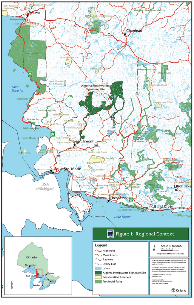
Figure 2: Protected Area Designation
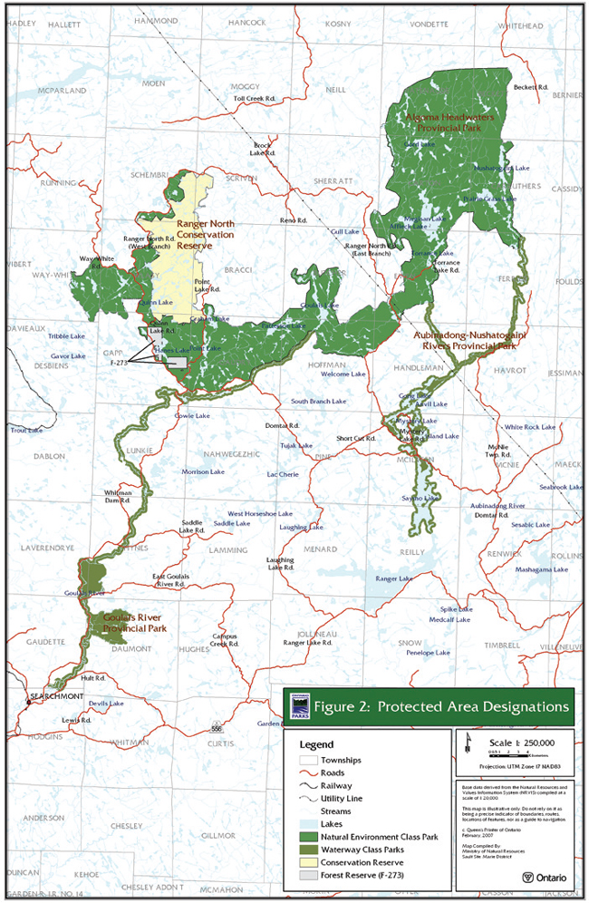
Figure 3: Existing Development
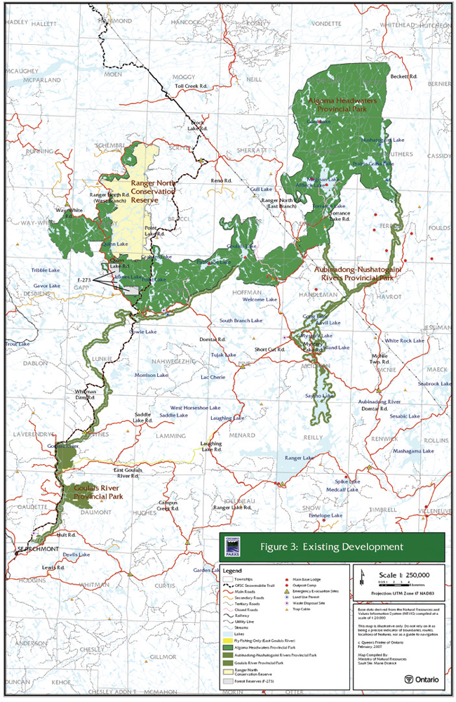
Figure 4: Zoning