Algonquin Provincial Park Management Plan: Amendment
This document provides amended policy direction for the protection, development and management of Algonguin Provincial Park and its resources.
© 2013, Queen’s Printer for Ontario
Additional copies of this publication are obtainable from the Ministry of Natural Resources or from the Algonquin Provincial Park office:
Algonquin Provincial Park
East Gate Complex, Highway 60
Telephone:
MNR #52727-0
ISBN 978-1-4606-2433-3 (Print) ISBN 978-1-4606-2434-0 (PDF)
Cette publication est également disponible en français.
Approval statement
I am pleased to approve this amendment to the Algonquin Provincial Park Management Plan (1998). The amendment provides revised direction in the management plan to implement the recommendations contained within the Joint Proposal for Lightening the Ecological Footprint of Logging in Algonquin Park.
I would like to express my sincere appreciation to the Board of Directors of Ontario Parks and the Algonquin Forestry Authority, the Algonquins of Ontario, the staff of Ontario Parks, key stakeholders and the public who participated in the planning process.
Sincerely,
Bradley Fauteux
Managing Director, Ontario Parks
Date 14/06/13
1.0 Context
1.1 Provincial Parks and Conservation Reserves Act
The Provincial Parks and Conservation Reserves Act, 2006 (PPCRA) has two specific principles that guide all aspects of planning and management of Ontario’s system of provincial parks and conservation reserves:
- Maintenance of ecological integrity shall be the first priority and the restoration of ecological integrity shall be considered.
- Opportunities for consultation shall be provided.
1.2 Statement of Environmental Values
The Ministry of Natural Resources’ (MNR) Statement of Environmental Values (SEV) under the Environmental Bill of Rights (EBR), describes how the purposes of the EBR are to be considered whenever decisions are made in the ministry that might significantly affect the environment. This includes decisions made as a result of preparing management direction for a protected area.
The ministry’s SEV has been considered throughout the plan amendment process. The management plan amendment for Algonquin Provincial Park will further the objectives of managing Ontario’s resources on an environmentally sustainable basis.
1.3 Planning context
The management plan has been prepared in compliance with provincial legislation and is consistent with direction contained in: Ontario Protected Areas Planning Manual (OMNR 2009a), Our Sustainable Future: A Renewed call to Action, Ministry of Natural Resources Strategic Directions (OMNR 2011a) in Renewing Our Commitment to Protecting What Sustains Us: Ontario’s Biodiversity Strategy (OMNR 2011b), and in Ontario Provincial Parks: Planning and Management Policies, 1992 Update (OMNR 1992).
1.4 Aboriginal context
The majority of Algonquin Provincial Park is situated within the traditional lands and territory of the Algonquins of Ontario. This plan amendment does not intend to affect, diminish or extinguish Aboriginal treaty rights, and associated traditional uses. The Algonquins of Ontario were involved throughout the development of this management plan amendment.
2.0 Purpose
The Algonquin Provincial Park Management Plan was approved in 1998. Encompassing an area of over 7,600 square kilometres, Algonquin is a Natural Environment park and has been planned, zoned and managed in accordance with the policies of this class of park. The goal of Algonquin Provincial Park is: To provide protection of natural and cultural features, continuing opportunities for a diversity of low-intensity recreational, wilderness, and natural environmental experiences; and within this provision continue and enhance the Park’s contribution to the economic, social, and cultural life of the region. Algonquin is unique in that it is the only provincial park in which forest management activities are permitted by provincial law and regulation. The Algonquin Park Forest Management Plan (2010-2020) must comply with the Algonquin Provincial Park Management Plan.
The purpose of this management plan amendment is to implement the recommendations contained in the Joint Proposal for Lightening the Ecological Footprint of Logging in Algonquin Park (2009), which comprised of:
- A recommendation that all area in Algonquin Park that is not available for forest management contribute to the summary of area protected from (or not available for) logging.
- A recommendation related to the expansion of protection zones to enhance the protection of under-represented ecosystems and important park values.
- A recommendation related to operational and planning strategies that will contribute to a lighter footprint in the areas where forest management activities occur.
- Implementation strategies for consideration when amending the Park Management Plan.
3.0 Background
At the time of the Provincial Parks Act review in 2005, the Minister of Natural Resources asked the Ontario Parks Board to provide advice on how to lighten the ecological footprint of logging in Algonquin Provincial Park.
The initial concept for lightening the ecological footprint received input from the Ontario Ministry of Natural Resources (MNR) and the Algonquin Forestry Authority (AFA), and resulted in the Ontario Parks Board making recommendations to the Minister of Natural Resources on December 8, 2006 in Recommendations of the Ontario Parks Board – Lightening the Ecological Footprint of Logging in Algonquin Provincial Park. The AFA provided the Minister with a separate proposal with substantial areas of agreement, but also differences that attempted to reduce some of the potential economic impacts of wood supply. Along with other recommendations, the Ontario Parks Board report suggested that the protection zones in Algonquin Park increase to 409,482 ha, or 54% of the park. The intent of the increase was to enhance protection of brook trout lakes, campsites, canoe routes, portages, old growth forests, and representative ecosystems. The document was placed on the Environmental Registry as an Information Notice for public review and comment on May 2, 2007 (EBR: 010-0445).
Based on Aboriginal, stakeholder and public comments received by the ministry, on February 28, 2008, the Minister of Natural Resources asked the Ontario Parks Board and the AFA Board to work together to develop joint recommendations. Input received from the Algonquins of Ontario (AOO) and key stakeholders was used to modify the joint recommendations. The resulting document titled Joint Proposal For Lightening the Ecological Footprint of Logging in Algonquin Park was accepted by the Minister of Natural Resources on November 2, 2009, and posted on the Environmental Registry (EBR: 010-8247).
An amendment to the Algonquin Provincial Park Management Plan (1998) was subsequently initiated by Ontario Parks to address the recommendations from the Joint Board Proposal. An invitation to review background information was posted on the Environmental Registry (EBR: 0108824) from January 20, 2010 to March 8, 2010. The proposed planned amendment was posted on the Environmental Registry with a comment period from July 25, 2012 to September 14, 2012.
4.0 Involvement
4.1 Summary and results of Algonquins of Ontario involvement
The Algonquins of Ontario involvement during the development of the Joint Proposal and the management plan amendment consisted of:
- Participation at meetings with representatives of the Ontario Parks and Algonquin Forestry Authority Boards (Joint Proposal, 2008);
- Participation on the technical MNR/AFA Working Group (Joint Proposal, 2009);
- Direct mailing of notices and draft documents to the AOO in advance of initiating formal stakeholder and public involvement inviting them to review and comment on Background Information for a Proposed Amendment to the Algonquin Provincial Park Management Plan To Address the Joint Proposal for Lightening the Ecological Footprint of Logging in Algonquin Park (January 2010);
- Meetings with AOO Algonquin Park Working Group representatives during the development of the proposed plan amendment (May to July 2010)
- Direct mailing of notices and draft documents to the AOO, in advance of initiating formal stakeholder and public involvement, inviting them to review and comment on the Proposed Algonquin Provincial Park Management Plan Amendment (July 2012)
- Ontario Parks meetings with AOO Algonquin Park Working Group to present the proposed plan amendment and address their comments and requests (August 2012 and April 2013)
4.2 Summary and results of stakeholder and public involvement
Stakeholders and the public were first invited to participate in the plan amendment for Algonquin Provincial Park on January 20, 2010, through a notification of public consultation on Background Information for a Proposed Amendment to the Algonquin Provincial Park Management Plan to Address the Joint Proposal for Lightening the Ecological Footprint of Logging in Algonquin Park. In addition to a mail out, advertisements were placed in a number of regional newspapers and a posting of the policy proposal was uploaded on the Environmental Registry. The Background Information document was also posted on the Ontario Parks and The Friends of Algonquin Park web sites. Comments on the Background Information were invited until March 8, 2010. Ontario Parks received 1,252 written submissions.
On July 25, 2012, stakeholders and the public were invited to comment on the Proposed Algonquin Provincial Park Management Plan Amendment until September 14, 2012. Direct notification was provided to those on the mailing list and publicized as a policy proposal notice on the Environmental Registry, advertisements in regional newspapers and posted on the Ontario Parks and The Friends of Algonquin Park web sites. Ontario Parks received 94 written submissions.
All comments received were fully considered in preparation of the final management plan amendment. There were some minor changes that were made to the final plan amendment based on comments received from the Algonquins of Ontario, Algonquin Forestry Authority, stakeholders and the public. Many other comments that were received and reviewed were determined to be outside of the scope of the Joint Proposal and will be taken into consideration at the time of the next Algonquin Provincial Park Management Plan examination.
5.0 Amendment to the Algonquin Provincial Park Management Plan (1998)
This section implements the recommendations of the Joint Proposal for Lightening the Ecological Footprint of Logging in Algonquin Provincial Park and identifies the various sections, sub-sections and page numbers in the Algonquin Provincial Park Management Plan where changes to management direction have occurred.
This amendment will accompany the Algonquin Provincial Park Management Plan as a stand-alone amendment. After the Management Plan undergoes its next examination the changes will be consolidated into the document.
5.1 Amend section 6.0 zoning
| Zone Type | Area (ha) | % of Park Area |
|---|---|---|
| Nature Reserve | 39,250 | 5.1 |
| Wilderness | 90,475 | 11.9 |
| Natural Environment | 13,765 | 1.8 |
| Historical | 1,680 | 0.2 |
| Development | 22,545 | 3.0 |
| Access | 735 | 0.1 |
| Recreation/Utilization Zone | 594,860 | 77.9 |
| Total | 763,310 | 100 |
| Zone Type | Area (ha) | % of Park Area |
|---|---|---|
| Nature Reserve | 51,462 | 6.8 |
| Wilderness | 104,792 | 13.7 |
| Natural Environment | 83,470 | 10.9 |
| Historical | 1,624 | 0.2 |
| Development | 22,502 | 3.0 |
| Access | 824 | 0.1 |
| Recreation/Utilization Zone | 498,785 | 65.3 |
| Total |
763,459 | 100 |
Addition (p.13) – new paragraphs below Zone Type table:
In 2013, 96,089 ha of protection zoning was added to Algonquin Park through a management plan amendment. These additions included: 12,198 ha to nature reserve zones; 14,292 ha to wilderness zones; 69,584 ha to natural environment zones; and 14.5 ha to historical zones. This enhanced protection brings the total area where forestry is not permitted by zoning from 168,450 ha (22.1% of the total park area) to 264,674 ha (34.7% of the total park area).
In addition to protection zoning, 107,648 ha
5.1.1 Amend section 6.1 Nature Reserve Zones
Addition (p.13):
A total of 12,198 ha has been added to the nature reserve zone system. Six of the nature reserve zones are new, and there are 24 additions to existing nature reserve zones. This brings the total number of nature reserve zones to 94. A description of each of the new nature reserve zones is given in Appendix A of this amendment and a description of the addition to each existing nature reserve zone is given in Appendix B of this amendment.
5.1.2 Amend figure 3 – Zoning summary
Addition (p. 14):
Figure 3b – Amendment to Zoning Summary Map (see Appendix C)
5.1.3 Amend section 6.1.1 natural heritage value identification and protection
Addition (p.15):
MNR used modeling and spatial information to assess ecological representation of landform/ vegetation complexes in Algonquin Park (Davis 2006, Crins and Kor 2000). The model identified areas of under-represented landform/vegetation complexes within ecoregions 5E-9 and 5E-10. The under-represented landform/vegetation complexes that existed within Algonquin Provincial Park became candidates for protection zoning.
New nature reserve zones were also based on additional information including: representation of terrestrial and aquatic life science features (e.g. self-sustaining brook trout lakes), degree of historical human disturbance, landscape diversity, ecological functions (e.g. size, shape and connectivity, hydrology, and old growth), and special values (e.g. rare species).
5.1.4 Amend section 6.1.3 life science
Addition (p.18):
New nature reserve Zones
Six new nature reserve zones were made to protect representative examples of landform/vegetation associations:
- North River Lake (N-92)
- Chela Lake (N-93)
- Parkline Lake (N-94)
- Roundbush Lake (N-95)
- Wilkins Lake (N-96)
- Gibson Lake (N-97)
For descriptions of these nature reserve zones refer to Appendix A of this amendment.
Additions to existing Nature Reserve Zones
Twenty-four additions were made to existing nature reserve zones. Boundaries of a number of nature reserve zone additions were established and modified to connect existing protection zones, provide boundaries based on more ecologically recognizable features, and capture local hydrological features and functions.
For descriptions of these additions to nature reserve zones refer to Appendix B of this amendment.
5.1.5 Amend section 6.2 Wilderness Zones
Addition (p.19):
Wilderness zone area in the park has been increased by 14,292 ha.
Two existing wilderness zones have been expanded to further maintain ecological integrity and the wilderness recreational experience of Park visitors.
Harness lake Wilderness Zone expansion
The Harness Lake wilderness zone has been expanded by 1,706 ha, primarily through added protection zoning around Ragged Lake and Big Porcupine Lake. These lakes are managed to preserve their natural and cultural features and provide recreationalists with an enhanced wilderness experience.
Burnt Island Wilderness Zone expansion
The Burnt Island wilderness zone has been expanded by 12,586 ha. This addition contributes to enhanced protection of natural and cultural features, and ecologically sustainable recreational opportunities in a wilderness setting. The expanded zone encompasses Shippagew, Longer, Lonely and Burntroot lakes, as well as Lake La Muir, Hogan and Philip lakes. These lake systems are situated on canoe routes with outstanding wilderness qualities.
5.1.6 Amend section 6.3 Natural Environment Zones
Addition (p.20):
A total of 69,584 ha has been added to the natural environment zone area in the park.
These new and expanded zones include aesthetic landscapes in which ecologically sustainable, low-intensity recreational use is permitted.
Newly established natural environment zones were based on the following criteria:
- 200 m protection along each side of high-use canoe routes which will enhance wilderness/solitude experience; in some areas zone boundaries were drawn between 200 m and 120 m to allow for practical road access;
- 120 m protection along each side of high-use canoe routes within areas with wood supply concerns;
- 120 m protection around the shoreline of Lake Opeongo and some medium to low-use canoe routes;
- 30 m protection along each side of some low-use canoe routes with wood supply concerns; and
- Areas of inaccessible or inoperable forest, areas that improve connectivity between existing core protection zones, and areas that protect natural heritage values.
Notable water bodies that have been protected include:
200 m Protection Zones
- Rain, Islet and McCraney lakes
- Magnetawan, Little Eagle, Hambone, Daisy, Ralph Bice, David, Mubwayaka, Little Trout, Queer, and Little Misty lakes
- Tim River, connecting Tim and Longbow lakes
- Nipissing River, flowing from the west Park boundary to Cedar Lake
- North Tea, Manitou and Kioshkokwi lakes
- Petawawa River, downstream from Perley to Cedar lakes
- Proulx, Little Crow and Big Crow lakes
120 m Protection Zones
- Western Uplands backpacking trail lakes including: Maple Leaf, Maggie, Guskewau, Little Hardy, Red Wing, Norah, East End and Ishkuday lakes
- Lake Opeongo
- Lake Louisa, Rence, Harry, Welcome lakes
- Pen and Clydegale lakes
- Opeongo River, including Tattler, Booth, Kitty, Shirley and Crotch lakes
- Sundassa, White Partridge and North Branch lakes
- Clemow and Grand lakes
- Petawawa River, downstream from Cedar Lake, including Radiant Lake, Lake Travers and McManus Lake
30 m Protection Zones
- Galipo lakes
- Little Cauliflower, Cauliflower, Little Hay and Hay lakes
- Blackfox, Hiram and Whitegull lakes
- Round Island, Presto and Chipmunk lakes
- Weasel, Bissett, Reed, Fitz and Gerald lakes
5.1.7 Amend section 6.4 Historical Zones
Addition (p.20):
The Farm Bay Depot historical zone (H-47) on the south shore of Galeairy Lake has been expanded by 14.5 ha (H-47B).
5.1.8 Amend section 6.7 Recreation/Utilization Zone
Delete the first sentence in the first paragraph (p.23):
“The Recreation/Utilization Zone in Algonquin Park encompasses 594,860 ha, which is split into a northern and southern section, divided by the Parkway Corridor.”
Replace with:
“The Recreation/Utilization Zone in Algonquin Park encompasses 498,785 ha, which is split into a northern and southern section, divided by the Parkway Corridor.”
Delete the first sentence in the fourth paragraph (p.23):
“Forest Management occurs in 73% of the Recreation/Utilization Zone (or 57% of the whole Park area).”
Replace with:
“Forest Management occurs in 78% of the Recreation/Utilization Zone (or 51% of the whole Park area).”
5.2 Amend section 8.0 stewardship policies
5.2.1 Amend section 8.1.3 aggregates
Addition (p.25):
- Consistent with existing protection zones, extraction of aggregate is not permitted in protection zones proposed in this amendment.
- The need for aggregate material for forest management purposes must be demonstrated to MNR in keeping with the PPCRA and the forest management plan.
- New aggregate pits are not permitted within the area of concern around self-sustaining brook trout lakes, as identified in the forest management plan, without written approval of the delegated authority.
- Aggregate use for forest access road construction and maintenance will be minimized in keeping with direction in the forest management plan.
- New and existing aggregate pits will be managed to minimize environmental impacts and will be rehabilitated consistent with the PPCRA and the forest management plan.
5.2.2 Amend section 8.4.2 hunting and trapping
Additions (p.32):
- Hunting and trapping are permitted to continue in new natural environment zones in Bruton, Clyde and Eyre Townships.
- Existing temporary hunt camps are permitted in new natural environment zones in Bruton, Clyde and Eyre Townships. Re-location of existing temporary hunt camps to outside of the new natural environment zones will be considered in the future between MNR and Bruton & Clyde Hunt Camp Association.
5.3 Amend section 9.0 operations policies
5.3.1 Amend section 9.2.1 areas of concern
Additions (p.42):
- MNR will ensure surveys are conducted to identify nursery creeks associated with self-sustaining brook trout lakes. An appropriate area of concern will be applied to protect identified fish habitat.
5.3.2 Amend section 9.2.5 roads and landings
Deletion (p.43):
- Roads are developed in accordance with the permanent forest management road system strategy and are contained within an approved Forest Management Plan.
Replace with:
- Forest access roads are planned, constructed and maintained consistent with the Forest Management Access Roads Strategy for the Algonquin Park Forest and direction contained in the current forest management plan.
Deletion (p.43):
- A long-term strategy for the development of tertiary roads will be produced based on wood flow. The specific location of tertiary roads will be pre-approved at the Annual Work Schedule Stage.
Additions:
- New forest access roads, skid trails or landings are not permitted in nature reserve, wilderness or historical zones proposed under this amendment.
- New forest access roads may be permitted in natural environment zones proposed under this amendment subject to approval by the delegated authority and A Class Environmental Assessment for Provincial Parks and Conservation Reserves (2005) and the Declaration Order Regarding MNR’s Class Environmental Assessment Approval for Forest Management on Crown Lands in Ontario (2003).
- If at some point it is found that practical road access for forestry operations has been restricted through this amendment, then a planning process (e.g. an amendment) may be initiated to address practical access.
- New forest access roads are not permitted within the area of concern around self-sustaining brook trout lakes, without written approval of the delegated authority and direction contained in the forest management plan.
- Forest access roads will be built to the minimum necessary standards, roads that will not be used for extended periods will be decommissioned and opportunities to rehabilitate abandoned roads will be investigated.
5.3.3 Amend section 9.2.7 road crossings of waterways and portages
Addition (p.43):
- Minimize impacts of water crossings to stream habitats through the continued use of portable bridges.
5.3.4 Amend section 9.2.8 transportation of timber and other activities
Addition (p.44):
- Forest management practices will continue to minimize impacts to ecological and recreational values, including the use of new and innovative forest equipment, navigational technologies, and analysis of forestry operations and recreational use patterns to maintain and enhance the park visitor’s experience, while maintaining a viable forest industry.
5.4 Amend appendices
5.4.1 Amend appendix F – Forest management strategies for each Park Zone
Deletion (p.71):
- Row number 4 (Natural Environment)
| Park Zone | Zone definition | Forest Management Yes | Forest management No | forest management Strategies |
|---|---|---|---|---|
| Natural Environment | Natural Environment Zones include aesthetic, natural and cultural landscapes in which there is minimum development required to support low-intensity back- country recreational activities. | X |
|
Replace with:
| Park Zone | Zone definition | Forest Management Yes | Forest management No | forest management Strategies |
|---|---|---|---|---|
| Natural Environment | Natural Environment Zones include aesthetic, natural and cultural landscapes in which there is minimum development required to support low-intensity back- country recreational activities. | X |
|
|
| Natural Environment | New natural environment zones established through the 2013 Park Management Plan Amendment. | X |
|
6.0 References
Algonquin Forestry Authority and Ontario Ministry of Natural Resources. 2010. Forest Management Plan for the Algonquin Park Forest Management Unit – 2010-2020.
Crins, W.J. and P.S.G. Kor. 2000. Natural heritage gap analysis methodologies used by the Ontario Ministry of Natural Resources: Version 2.0 Open File Natural Heritage Technical Report 2000-1. Ontario Ministry of Natural Resources, Lands and Natural Heritage Branch, Natural Heritage Section, Peterborough, Ontario, 27p.
Davis, R.G. 2006. GapTool Users Guide. Ontario Ministry of Natural Resources, Peterborough, Ontario. 51p. + app.
Environmental Bill of Rights 1993. S.O. 1993. Chapter 28. Retrieved from the Ministry of the Attorney General Ontario website
OMNR. 1992. Ontario Provincial Parks: Planning and Management Policies, 1992 Update. http://www.ontarioparks.com/english/pdf/bluebook.pdf [link inactive]
OMNR. 1998. Algonquin Provincial Park Management Plan. Queen’s Printer for Ontario.
OMNR. 2005. A Class Environmental Assessment for Provincial Parks and Conservation Reserves.
OMNR. 2007. Declaration Order Regarding MNR’s Class Environmental Assessment Approval for Forest Management on Crown Lands in Ontario (Declaration Order MNR-71 (2003) and Amending Order MNR-71/2 (2007)).
OMNR. 2009b. Ontario Protected Areas Planning Manual. Queen’s Printer for Ontario, Peterborough. http://www.ontarioparks.com/english/planning_pdf/papm/papm_approved.pdf [link inactive]
OMNR. 2010. Background Information for a Proposed Amendment to the Algonquin Provincial Park Management Plan To Address the Joint Proposal for Lightening the Ecological Footprint of Logging in Algonquin Park. http://www.ontarioparks.com/english/planning_pdf/algo/algo_background_amendment.pdf [link inactive]
OMNR. 2011a. Our Sustainable Future: A Renewed Call to Action – Ministry of Natural Resources Strategic Directions. Queen’s Printer for Ontario, Toronto.
OMNR. 2011b. Renewing Our Commitment to Protecting What Sustains Us: Ontario’s Biodiversity Strategy.
Ontario Parks Board of Directors. 2006. Recommendations of the Ontario Parks Board: Lightening the Ecological Footprint of Logging in Algonquin Park.
Ontario Parks Board of Directors and the Algonquin Forestry Authority Board of Directors. 2009. Joint Proposal for the Lightening the Ecological Footprint of Logging in Algonquin Park.
Provincial Parks and Conservation Reserves Act, 2006. S.O. 2006, Chapter 12. Retrieved from the Ministry of the Attorney General Ontario website: Provincial Parks and Conservation Reserves Act, 2006, S.O. 2006, c. 12
7.0 Appendices
Appendix A: New Nature Reserve Zones
| Id | Name | Size (ha) | Township | Natural Values and Features |
|---|---|---|---|---|
| N-92 | North River Lake | 2,729 | Deacon | Sugar Maple dominated forests on Precambrian basic-intermediate bedrock and open marsh, fen, and bog habitats. |
| N-93 | Chela lake | 959 | Deacon | Dominated by mixed tolerant hardwoods including stands of Red Oak, Red Pine, White Pine, and Yellow Birch growing on Precambrian basic- intermediate bedrock. |
| N-94 | Parkline Lake | 311 | Bronson | Red Oak growing on Precambrian basic-intermediate bedrock is the predominant landform/vegetation complex. Aspen and other intolerant deciduous species also occur. |
| N-95 | Round- bush Lake | 319 | Clancy | White Birch, Aspen, and to a lesser extent White Spruce, occurring on Precambrian basic-intermediate bedrock. A Black Spruce and thicket swamp also occurs where the Alyen River flows into Roundbush Lake. |
| N-96 | WilkinsLake | 414 | Clancy | Tolerant and intolerant hardwoods and Hemlock occur on organic deposits. |
| N-97 | Gibson Lake | 1,843 | Biggar | Predominately glaciofluvial outwash and glaciofluvial esker-kettle terrains. Black Spruce and Balsam Fir occur in lower lying areas while Sugar Maple and White Pine dominate upland areas. |
Appendix B: Additions to existing Nature Reserve Zones
| ID | Zone | Size (ha) | Township |
|---|---|---|---|
| N-2B | N-2 David Creek Bog | 4 | Butt |
| N-6B | N-6 Hogan Lake Mog | 8 | Freswick |
| N-9B | N-9 Cedar Nipissing Marsh | 33 | Lister |
| N-13B | N-13 Booth Lake Bog | 483 | Preston |
| N-17B | N-17 Nipissing River Sedge Meadow | 359 | Osler |
| N-19B | N-19 Nadine Lake Hardwoods | 614 | Osler |
| N-20B | N-20 Carl Wilson Lake Hardwoods | 1,002 | Lister/ Boyd |
| N-23B | N-23 Wenda Lake Hardwoods | <1 | Barron |
| N-24B | N-24 Whitson Lake | 8 | Bronson Stratton |
| N-26B | N-26 Rana Lake Red Oak | 90 | Deacon |
| N-31B | N-31 Cayuga Lake Hemlock | 57 | Ballantyne |
| N-47B | N-47 Oak Lake Red Spruce | 53 | Finlayson |
| N-48B | N-48 Rosebary Lake | 5 | Devine |
| N-49B | N-49 Tarn Lake | 3 | Master |
| N-50B | N-50 Carcajou Bay/ Spectacle Lakes | 1,163 | Barron |
| N-53B | N-53 Upper Pine River | 25 | Master |
| N-55B | N-55 Petawawa Rapids | 144 | Bronson Edgar |
| N-57B | N-57 Barron River Canyon | 32 | Stratton |
| N-62B | N-62 Brent Crater | 44 | Deacon |
| N-65B | N-65 Cauchon Lake Burn | 137 | Boyd |
| N-69B | N-69 Coldspring Watershed | 1,128 | Biggar Osler Devine Bishop |
| N-78B | N-78 Minnehaha Lake Kame Moraine | 58 | Osler |
| N-87B | N-87 Big Crow Lake Esker Complex | 162 | Anglin |
| N-89B | N-89 McKaskill Lake Kame Complex | 10 | Clancy |
Appendix C: Figure 3b - Amendment to zoning summary map / Sommaire de la modification au zonag
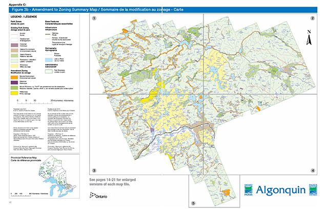
Enlarge figure 3b - Amendment to zoning summary map (PDF)
Part 1: Amendment to zoning summary map
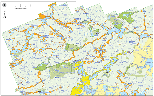
Enlarge part 1: Amendment to zoning summary map (PDF)
Part 2: Amendment to zoning summary map
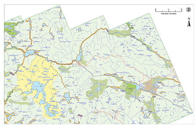
Enlarge this map part 2: Amendment to zoning summary map (PDF)
Part 3: Amendment to zoning summary map
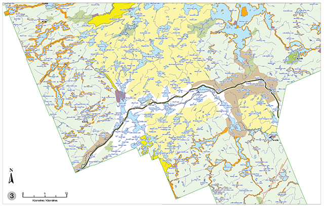
Enlarge part 3: Amendment to zoning summary map (PDF)
Part 4: Amendment to zoning summary map
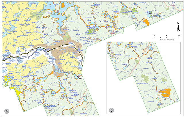
Enlarge part 4: Amendment to zoning summary map (PDF)
MNR# 52727-0 • 1K P.R. 07 26 13 • ISBN 978-1-4606-2433-3 (Print) ISBN 978-1-4606-2434-0 (PDF)
© Queen’s Printer for Ontario, 2013
Footnotes
- footnote[1] Back to paragraph Note: Since the publishing of the park management plan, improved geo-spatial information and technology has resulted in more accurate area figures for park zones. Total Park Area reported here differs from that reported in the Joint Board Proposal due to a discrepancy in the data source used for analysis in the Joint Board Proposal.
- footnote[2] Back to paragraph The total area not available for forest management as a result of areas of concern (AOCs) may vary over time as new values are identified, removed or prescriptions change.