Balsam Lake Provincial Park Management Plan
This document provides direction on the management of Balsam Lake Provincial Park.
Additional copies of this publication are obtainable from:
Ministry of Natural Resources
10670 Yonge Street
Richmond Hill, Ontario L4C 3C9
© 1985, Government of Ontario
We are pleased to approve the Balsam Lake Provincial Park Management Plan, as official policy for the management and development of this park. The plan reflects this Ministry’s intent to protect natural features of Balsam Lake and maintain and develop high quality opportunities for outdoor recreation and heritage appreciation for both residents of Ontario and visitors to the Province.
M. Fordyce Richards
Regional Director, Central Region
N. Richards
Director Parks and Recreational Areas Branch
1. Introduction
Balsam Lake Provincial Park (hereafter referred to as "Balsam" or "the park") is situated on the northwest shore of Balsam Lake, in Bexley Township, County of Victoria. The park is approximately 45-km northwest of the Town of Lindsay, and approximately 142 km north of Metro Toronto.
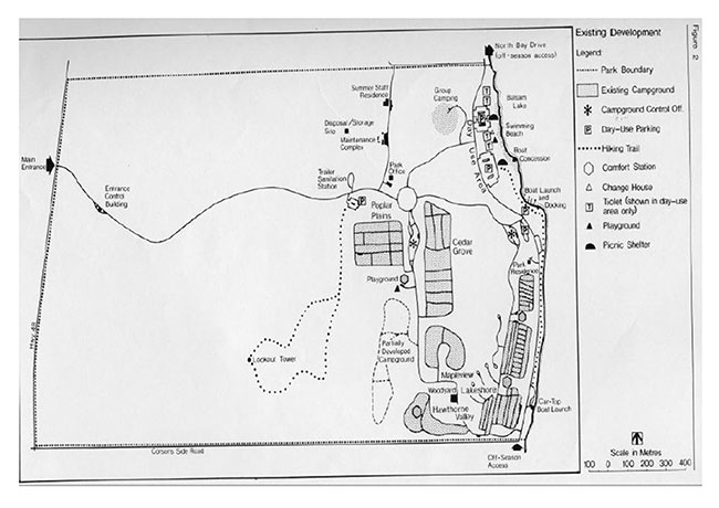
The park is located on a land base of 432 hectares (see Section 3.4, Park Boundary). Balsam has 489 campsites (6 of which are on a trial walk-in basis) and 3 group sites. Parking capacity in the day-use area is approximately 450 vehicles.
The park offers its visitors recreational opportunities based on: a sand beach, Balsam Lake (which is part of the Trent-Severn Waterway System), landscaped backshore areas, boat launching and docking facilities, campgrounds, hiking trails, and a large section of the park which is partially reforested and partially pasture – like open space. From 1980 to 1983, day-use attendance increased 11% to approximately 11,000 visitors annually. During this same period, camper nights increased by .5%. In July and August of 1982, the park had 58% campsite occupancy.
Noteworthy landscape features found within the park are the following surficial features deposited and formed at the time of the last ice retreat and subsequent high water levels: an esker, and esker- kame complex and a drumlin.
It is for the purpose of planning, development and management of the park’s natural and recreational resources that this management plan is being prepared.
2. Summary of Significant Issues and Policy Decisions
The park is presently being administered and operated from several buildings (e.g., two campground offices, 1 entrance control booth, 1 park office). Operating, staffing and maintaining all of these buildings is becoming increasingly costly and inefficient. All of these administrative services and functions will be amalgamated to one complex, strategically located to satisfy all functions.
Since the recreational potential of the park’s land base is not fully realized and since recreational demands suggest facility underdevelopment, this plan suggests an increase and diversification in recreational opportunities and experiences.
3. Park Policies
3.1 Park Classification
According to the Provincial Parks Classification System, Balsam is a "Recreation Park". Parks in this classification are defined as "are as which can support a wide variety of outdoor recreation opportunities for large numbers of people in attractive surroundings".
3.2 Park Goal
To provide a diverse and wide variety of recreation opportunities and to protect significant natural resources.
3.3 Park Objectives
3.3.1 Recreation Objective
The recreation objective of the Ontario Provincial Parks system is to provide outdoor recreation opportunities ranging from high-intensity day use to low-intensity wilderness experiences.
Figure 1: Regional Context
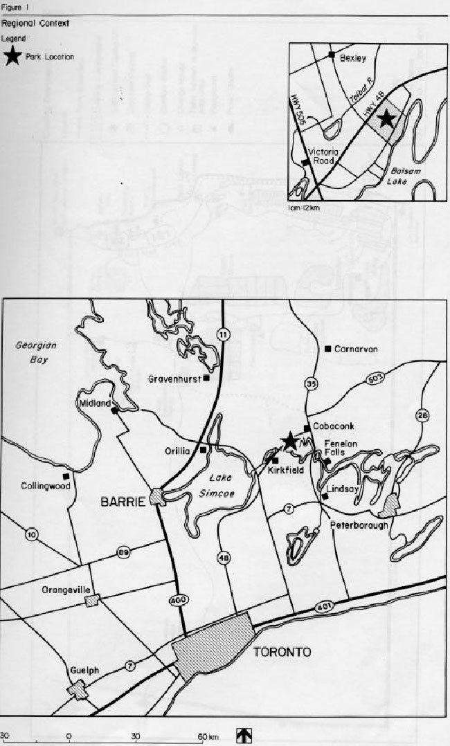
Figure 2: Existing Development
The recreation objective for this park is to provide year-round intensive and extensive outdoor recreation opportunities and facilities that utilize the area’s prime land and water recreational resources. According to the Lindsay District Land-Use Guidelines:
- the park’s 489 campsites are estimated to represent 26% of the camping opportunities in the district to the year 2000 (the park presently offers 38% of these opportunities)
- the park’s 340 m of beach are estimated to represent 9% of the swimming opportunities in the district to the year 2000 (the park presently offers 41% of these opportunities)
- the park’s 250 day-use picnic tables are estimated to represent 10% of the picnicking opportunities in the district to the year 2000 (the park presently offers 20% of these opportunities) (N.B.) The difference in camping, swimming and picnicking percentile opportunities between present day and the year 2000, represents an estimated increase in the number of similar opportunities to be made available elsewhere and does not reflect any proposed decrease in facility based opportunities at Balsam.
3.3.2 Heritage Appreciation Objective
The heritage appreciation objective of the Ontario Provincial Parks system is to provide opportunities for the exploration and appreciation of the outdoor natural and cultural heritage of Ontario.
The heritage appreciation objective for this park is to provide a range of opportunities for the exploration, interpretation and appreciation of the natural features of the park including the shoreline, vegetation communities and the esker-kame complex.
3.3.3 Tourism Objective
The tourism objective of the Ontario Provincial Parks system is to provide Ontario’s residents and out-of-province visitors with opportunities to discover and experience the distinctive regions of the Province.
The tourism objective for this park is to provide Ontario residents and out -of-province visitors with opportunities to discover and experience the Balsam Lake region. The park, in 1979, contributed almost three million dollars to the provincial economy through park expenditures and tourist spending. It is the objective of the ministry to maintain and possibly increase the economic contribution of this park to the local economy.
3.3.4 Protection Objective
The protection objective of the Ontario Provincial Parks system is to protect provincially significant elements of the natural and cultural landscape of Ontario.
The protection objective for this park is to protect the regionally significant esker-kame complex and several locally significant vegetative communities through zoning that is sensitive to the particular resource management needs of the park’s features as well as to the recreational pressures placed on these resources.
3.4 Park Boundary
The park’s 432 hectares refers to its land base. However, regulation of the park includes 448 hectares. The difference involves the park’s offshore waters, which are actually under federal jurisdiction. A working agreement with the Trent-Severn Waterway will be negotiated in the future in order for the park to obtain authorization for management of the offshore area. The final dimension and size of this extension of the park’s jurisdiction will be determined during these negotiations. The present regulated waterlot extends 91.5 m from shore and includes 16 hectares.
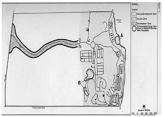
3.5 Zones and Zone Policies
All lands within the park will be zoned (see Figure 3) in recognition of their’ environmental qualities, required protection and their potential for recreational use within the context of the objectives of the park.
Summary of Zoning (land base only)
| Zones | Hectares |
|---|---|
| Development | 162 |
| Natural Environment | 252 |
| Access Zone | 18 |
3.5.1 Development Zone
This zone contains the more intensive recreational facilities and activities such as picnicking, swimming, boat launching, docking and camping. The park’s administration and maintenance buildings are also located in this zone. The following is a description of two small environmentally sensitive areas located in this zone:
Area A - Any expansion of docking facilities, near this area, must be carefully designed and sited so as to have minimum impact of this coastal backshore wetland’s environment.
Area B - This area has been identified as worthy of protection from indiscriminate forms of development. Expansion of camping (walk-in) facilities (see Section 6.1, Campground Development) into this area must be done so as to have minimum environmental impact on the vegetation and soils.
Development Zone Policies
- To improve the landscape aesthetics and the environmental quality of this zone through landscape plantings, reforestation, and drainage improvements
- To maximize recreational opportunities by maintaining and improving upon existing resources/facilities and the provision of new facilities as deemed necessary
3.5.2 Natural Environment Zone
The natural environment zone contains a rolling and partially wooded landscape with a significant esker-kame complex.
Natural Environment Zone Policies
To protect the natural features found in this area from detrimental forms of development and recreational use.
- To allow appropriate forms of recreational activities to occur.
- To monitor these appropriate recreational activities to ensure no future detrimental effect develops affecting the zone’s resources.
- To take approved management initiatives to improve and enhance the environmental qualities and resources found in this area.
Figure 3: Zoning
3.5.3 Access Zone
This zone provides an entrance and access to the park and its recreational facilities.
Access Zone policies
To improve the aesthetic character of the park entrance and access road.
To satisfy the needs of park patrons, highway travelers and park administrators, new facilities will be provided and existing facilities modified.
4. Resource Management
4.1 Landform and Water Management
Balsam Lake shorebluff erosion is a natural dynamic process. Engineered means of stabilizing the shorebluff will not be undertaken because of the cost. Instead, the effects of erosion will be minimized by:
- establishing plant species along the shorebluff that are adapted to stabilizing slopes
- site planning set-backs of all facilities from the bluff edge
- controlling pedestrian circulation on the bluffs by strategically locating vegetative barriers and shorebluff stairs, as required
- The area previously used as a dump/storage site will be reduced in size and used as storage only. The area no longer will be rehabilitated to a natural state
- The beach area will be replenished with imported sand as needed
- The understanding between the Ministry of Natural Resources and Bexley Township, regarding the maintenance and improvement of North Bay Drive, will be periodically reviewed
- Park Drainage - Landform Survey
- In order to resolve drainage problems in the development zone, a landform survey is required. This will enable drainage problems to be resolved while working with the basic hydrological features of the park
4.2 Vegetation Management
- All proposed planting projects will be directed by an approved planting and maintenance program as stipulated in a Vegetation Management Plan.
- Non-threatening native forest and vegetation insects and diseases normally will be allowed to develop undisturbed. Control measures, if necessary, will be taken if the aesthetic values inside or outside the park are threatened. Where control is desirable and feasible, it will be directed as narrowly as possible to the specific insect or disease, so as to have minimal effects on other components of the park’s environment.
4.3 Fauna Management
When the park receives authorization to manage its offshore waters, commercial fishing and bait fishing will not be allowed in these waters.
- Sport hunting or commercial trapping will not be allowed.
- Animal control if necessary may be carried out under the strict supervision of or directly by the Ministry of Natural Resources.
- Sport fishing (angling) will be encouraged, in season, offshore from the park.
5. Client Services Management
5.1 Visitor Services
Balsam, as a major recreation-oriented Provincial Park, provides a wide variety of quality visitor services. Of the four visitor service components (communication, recreation, interpretation and outdoor education), the former two are emphasized at the park. Accomplishment of the latter two components may result from a cooperative interpretive/ education program involving the ministry and the Kawartha Region Conservation Authority.
5.1.1 Communication
Objectives of this component should include the following:
- informing visitors about the park, its services, facilities and management concerns
- informing visitors about recreation and interpretive opportunities in the local area
- informing visitors of the role of the Ministry of Natural Resources
- instilling a sense of respect in visitors for the park environment
- providing a means of feedback for visitors to communicate with the Ministry
The objectives outlined above will be achieved through all or some of the following: A publication, signage, audio- visual presentations, displays, mass media and personal contact involving campsite visitation.
5.1.2 Recreation
The park’s self-use and staff-led recreation activities will include:
- recreational skills that will be emphasized at Balsam because of the park’s outstanding
- recreational resources. Instruction will focus on water-based recreation and will include topics such as water safety, sailing, wind surfing, canoeing and fishing.
- to supplement the park’s recreation facilities, a free recreation-equipment loan program may be offered.
- limited staff-led recreation activities will be provided as funds and staff priorities permit. They may include campfire, craft and water-oriented programs.
5.1.3 Interpretation
Interpretation will be a minor component of the visitor services program. The esker-kame complex will be interpreted primarily through self- use displays, a brochure, a lookout tower and a trail. All of the above themes can as well be interpreted in evening programs.
5.1.4 Outdoor Education
Balsam will be made available to educational groups who wish to use the park as an outdoor classroom. Facilities that will enhance this experience include the nature trail, display boards, observation platform and the proposed amphitheatre.
5.2 Recreation Management
- The Park will be accessible on a year-round basis, for day-use and camping opportunities. Camping will be fully serviced in the summer and primitive in the winter.
- Off-season access and parking is provided on Balsam Lake Drive and the boat-launching parking Lot, respectively.
- Park activities and facilities will be directed by guidelines and procedures in accordance with the Balsam Lake Provincial Park Management/Operating Plan.
- A mandate of this park is to redevelop and/or expand primary recreational facilities in order to offer a better diversity in recreational opportunities. This will be achieved by making use of the park’s available and undeveloped resource base. The variety and quality of recreational opportunities will also be increased (e.g., development of walk-in campsites, phasing out poorly sited campsites).
- The park will provide more docking opportunities for not only park patrons, but also for boaters using the Trent-Severn Waterway System
- In order to spread campsites with electrical service throughout the park, future sites with electricity will be located in one of the inland campgrounds.
- Horseback trail riding may be allowed pending further investigation. Activities compatible with the park environment will be allowed as the district parks and recreation section and park superintendent deems suitable.
5.3 Commercial Services
The following existing commercial services are available at the park:
- wood concession
- boat rental
- laundry
In addition, a fast-food outlet may be provided on a trial basis. Additional concessions may be added or existing ones modified in some way, according to the district parks and recreation section, the park superintendent, as well as in keeping with park goals and objectives.
5.4 Marketing
The following is a priority ranking of Provincial Park marketing strategies, which apply to Balsam.
- Hold present customers longer
- Repatriate customers lost during the rowdyism of the 70’s
- Attract day users who will stay in local service accommodations and use local services.
- Expand demand for camping by working with private campground operators
- Increase day use where high volume (i.e., groups) can be achieved
Marketing and operational initiatives, as outlined in the "Marketing Manual for Balsam Lake Provincial Park", will be implemented in order to obtain the above results.
6. Development
The following is a list of development items that are proposed for the park (Proposed Development, Figure 4). Approved site plans are required for all development.
6.1 Campground
A new campground containing approximately 40 campsites will be developed in stages. These new sites will replace approximately the same number of existing sites in the Poplar Plains Campground that will be permanently closed due to poor siting. The total number of campsites will remain at approximately 480.
Figure 4: Proposed Development
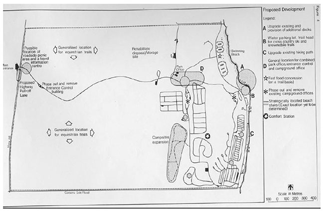
On a phased-in trial basis, these new sites will be developed as walk-in sites, requiring little investment. Depending on camper acceptance and reaction, the entire 40 new campsites may be developed as walk-in, or just a few, leaving the remaining sites to be developed as conventional car sites as site conditions permit.
A Campsite Rehabilitation Plan will be prepared allowing up to 10% of the sites being closed at one time if necessary. Under this plan, approximately 435 sites will be open for campers at any one time. This plan will also look at the group campground.
Limited overnight boat-in mooring facilities may be provided. These facilities will be standards required under the Environmental Protection Act. Park visitors in this circumstance will spend the night on their boat, and have access to the park’s facilities and services. Additional docking facilities are proposed to the east of the existing facility. Existing campground facilities (comfort stations, water, and laundry) are adequate to service the needs of these boat-in users.
An additional fully-serviced comfort station (showers and laundry) will be provided north of the Mapleview Campground.
A playground will be located in the Lakeshore campground.
6.2 Trails
A Trail Development and Maintenance Plan will be prepared for all of the park’s existing and proposed trails.
The path that follows the edge of the shorebluff through the campground will be upgraded. A fitness trail will also be introduced along this same path.
A cross-country ski trail will be provided.
A bicycle route will be designated, following an established road network with linking paths.
Day-use equestrian trails in the front (west) portion of the park will be allowed on a trial basis. Riding will be allowed in the park by horse owners on a day use or overnight camping basis or offered through concession arrangement. In planning equestrian trails through this area, careful consideration will be given to protecting the esker-kame complex.
6.3 Administrative Facilities
The administrative services and functions of the entrance control booth, park office and campground offices may be amalgamated to one complex pending priorities and funding. Buildings, not required, will be phased out. Some road realignment may be necessary. Further detailed cost/benefit analysis, site analysis and site design will determine the outcome of this proposal.
A visitor services office will be provided in the new structure.
An amphitheatre will be provided in an area with convenient access to the campgrounds, as well as to the proposed visitor services office. The feasibility of locating a Tourist Information Centre, adjacent to Highway #48, in the access zone, will’ be investigated. This facility will be administered by local agencies or another government agency such as the Ministry of Tourism and Recreation, with the park providing the land base. A roadside rest stop (picnic area) may also be located here.
7. Implementation Strategy
The following is a priority listing in decreasing order of importance of projects planned for the park. All projects will be implemented as funds and priorities permit.
- rehabilitation of the dump/storage site
- a playground (in Lakeshore Campground)
- boat dock expansion (add 3-7 more 15 m docks to existing 7 docks depending on detailed site analysis)
- upgrading of existing path along shoreline into a hiking path (includes access stairs to beach)
- provision of bicycle path
- development of 40 new campsites, as walk- in closing and rehabilitating 45 existing sites
- new fully-serviced comfort station
- completely new structure to assume responsibilities of phased-out entrance control, campground offices and park office (includes adjacent amphitheatre)
- 500 m of new road (required if totally new building is sited)
- removal of 300 m of existing road
- plans to be prepared include a Vegetation Management Plan, a Campsite Rehabilitation Plan, a Trail Development and Maintenance Plan as well as a landform survey.
This management plan will be reviewed when major issues surface and at least once within the next ten years. Any necessary plan amendments will be made with public involvement in accordance with apparent needs.
8. Public Consultation
Though this current management planning effort was initiated in 1983, the actual management planning process for this park began in the late 1970’s.
To date:
- public participation has involved an open house meeting, held at the park, on Saturday October 14, 1978
- a management planning brochure, outlining the issues and concerns of the park and soliciting responses, was handed out at the above-mentioned meeting as well as being distributed during the summer of 1979 at the park
- further public comments were received in the summer of 1982, when a provincial park day use and camper opinion survey was conducted at the park
- Recent public consultation during the management planning process for Balsam focused on the local area and included the following:
- a news release and an advertisement in the Lindsay Daily Post, Lindsay This Week, Fenelon Falls Gazette and the Haliburton County Echo and Minden Recorder advising that this management plan was available for review at the park and/or district office
- copies of this plan forwarded to local levels of government for review (Township of Bexley, County of Victoria, Kawartha Region Conservation Authority)
- copies of the news release sent to interest groups (North Bay Drive Association, Indian Point Association, Balsam Lake Cottager’ s Association, Federation of Ontario Naturalists, and Ontario Federation of Anglers and Hunters)
- where appropriate, contact will be made with adjacent landowners, by park management, to inform these landowners of the plan and its contents
- announcements and posters on display in the park during the summer of 1984 advising park visitors of availability of plan for review at the park office
All comments and suggestions received from the public were considered while finalizing this plan.
9. References
Burns, J. A.; Archaeological Survey of Balsam Lake Provincial Park, Bexley Township, Victoria County, 1972, Ontario Ministry of Natural Resources.
Ontario Ministry of the Environment; Report on Water alit , 1971, Recreational Lakes Pro ram.
Ontario Ministry of Natural Resources; Lake Survey- Balsam Lake, 1972.
Ontario Ministry of Natural Resources; Balsam Lake Provincial Park, Preliminary Mas ter Plan, 1980.
Ontario Ministry of Natural Resources; 1982 Provincial Park Camper Survey, Summary Statistical Report , 1983.
Ontario Ministry of Natural Resources; Balsam Lake Provincial Park Management Plan- Background Information Document, 1984.
Ontario Ministry of Natural Resources; 1982 Provincial Park Day-User Survey, Summary Statistical Report , 1983.
Ontario Ministry of Natural Resources; Lindsay District Land Use Guidelines , 1983.
Ontario Ministry of Natural Resources; Ontario Provincial Parks Planning and Management Policies , 1978.
Ontario Ministry of Treasury and Economics; 1981 Ontario Statistics, Central Statistical Services .
Victoria County Planning Board; Official Plan, March 1978.
Victoria County Planning Board; Summary of Background Reports and Goals and Objectives , 1977.