Balsam Lake Provincial Park Management Plan (Published 2018)
This document provides direction on the management of Balsam Lake Provincial Park.
Approval statement
February 1, 2018
I am pleased to approve the Balsam Lake Provincial Park Management Plan as the official policy for the management of this protected area. The plan reflects the intent of the Ministry of Natural Resources and Forestry, Ontario Parks to protect the natural, cultural and recreational features of Balsam Lake Provincial Park and to maintain and develop opportunities for high quality ecologically sustainable outdoor recreation experiences and heritage appreciation for the residents of Ontario and visitors to the province.
This document outlines the site objectives, policies, actions and implementation priorities related to managing the park’s natural, cultural and recreational values, and summarizes the involvement of Indigenous communities, the public and stakeholders that occurred as part of the planning process.
The plan for Balsam Lake Provincial Park will be used to guide the management of the park over the next 20 years. During that time, the management plan may be examined to address changing issues or conditions, and may be adjusted as the need arises.
I wish to extend my sincere thanks to all those who participated in the planning process.
Bruce Bateman
Director, Ontario Parks
1 Introduction
Balsam Lake Provincial Park is located on the northwest shore of Balsam Lake, in the geographic Township of Bexley, City of Kawartha Lakes (formerly Victoria County) (Figure 1). The park is approximately 45 kilometres (km) northwest of the town of Lindsay and approximately 140 km north of Toronto. The park is 449 hectares (ha) in size. The park boundary is shown in Figure 2.
Balsam Lake Provincial Park was regulated under the Provincial Parks Act in 1968 (Ontario Regulation 320/68). The park offers recreational activities such as camping, swimming, boating, fishing, picnicking, wildlife viewing, and hiking. Self-use cross-country skiing and snowshoeing are also available in the winter.
Located in Ecodistrict 6E-9, the park is considered locally significant, with moderate representation of a number of natural heritage features including several provincially and locally significant species. The site protects a mosaic of coniferous, mixed and deciduous forests, regenerating farm fields, thickets, savannahs and conifer plantations, as well as swamps, a fen, and marshes. The park contains minor headwater areas, small watersheds, and supporting habitat for grassland bird species.
Figure 1: Regional setting
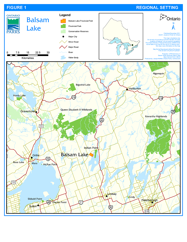
Enlarge Figure 1: Regional setting map
2 Planning context
The Provincial Parks and Conservation Reserves Act, 2006 (PPCRA) requires that management direction is prepared for each protected area in Ontario. This management plan fulfils this requirement, and provides direction for managing Balsam Lake Provincial Park, including the park’s purpose and vision, objectives, zoning, policies and implementation priorities. This management plan is written with a 20 year time horizon in mind.
The PPCRA has two guiding principles for park planning and management:
- Maintenance of ecological integrity shall be the first priority and the restoration of ecological integrity shall be considered.
- Opportunities for consultation shall be provided.
Other legislation (e.g., Endangered Species Act, 2007 (ESA), Ontario Heritage Act, 2005 (OHA)), policies, initiatives (e.g., climate change mitigation and adaptation, invasive species control) and best practices (e.g., adaptive management, landscape level planning) also provide additional direction for protecting Ontario’s biodiversity and contribute to guiding protected area planning and management.
This park management plan has been prepared consistent with all relevant legislation and provincial policies. The implementation of projects in this provincial park will comply with the requirements of A Class Environmental Assessment for Provincial Parks and Conservation Reserves (Class EA-PPCR). This may include further opportunities for consultation, as required.
2.1 Ecological integrity
The PPCRA defines ecological integrity as follows:
Ecological integrity is a concept that addresses three ecosystem attributes: composition, structure and function. This concept is based on the idea that the composition and structure of the protected area should be characteristic for the natural region and that ecosystem functions should proceed normally. Simply stated, ecosystems have integrity when their lands, waters, native species and natural processes are intact.
All planning and management activities for Balsam Lake Provincial Park will consider ecological integrity first and foremost in their implementation.
3 Indigenous communities
The Balsam Lake area was originally occupied by ancestors of the Mississauga Nations. The property on which the park is located is in Treaty 20, an 1818 pre-confederation Treaty with the British Crown and Mississauga Nations.
Balsam Lake Provincial Park is located within the traditional territory of the Williams Treaties First Nations, which includes the Mississaugas (Alderville, Hiawatha, Scugog Island and Curve Lake First Nations) and Chippewas (Beausoleil, Georgina Island and Rama First Nations). The Kawartha Nishnawbe assert that it is also within their traditional territory.
4 Park classification
Through park classification, Ontario’s provincial parks are organized into broad categories, each of which has particular purposes and characteristics. Balsam Lake Provincial Park is classified as a recreational class park.
Recreational class parks support a wide variety of sustainable outdoor recreation opportunities in attractive surroundings. This classification has been assigned to the park in recognition of the variety and quality of recreational opportunities it provides.
5 Boundary
Balsam Lake Provincial Park is 449 ha in size. The park boundary extends 91.5 m in perpendicular distance along the lakebed from the water’s edge into Balsam Lake (Figure 2).
Balsam Lake Provincial Park is completely surrounded by private land with the exception of where the park abuts Balsam Lake. Land adjacent to the park is used for agricultural purposes, recreational cottages and year-round homes.
Park management plan policies apply only to the area within the regulated boundary of the park. Within the park boundary, the protection of park values and features will be achieved through appropriate zoning, the control of land use and activities, education and monitoring of ecological impacts.
Ontario Parks will support, in principle, the acquisition of property for addition to the park, where the property will enhance park values. Potential acquisitions will be evaluated with regard to their contribution to park objectives, and will be considered on a willing buyer, willing seller basis, subject to available resources.
Figure 2: Park boundary
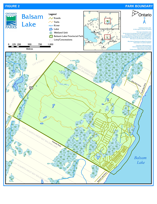
Enlarge Figure 2: Park boundary map
6 Purpose
The purpose of Balsam Lake Provincial Park is:
Balsam Lake Provincial Park is a popular destination for campers and day-use visitors due to its excellent recreation opportunities and proximity to large population centres. Efforts will be made to ensure visitor use and park values are managed sustainably. This will be achieved by encouraging the growth and regeneration of native vegetation, effectively distributing use throughout existing facilities, and ensuring that site planning and the development of new facilities is consistent with protecting the overall ecological integrity of the park.
7 Objectives and values
7.1 Protection objective
Ontario’s provincial parks play an important role in representing and conserving the diversity of Ontario’s natural features and ecosystems across the broader landscape. Protected areas include representative examples of life and earth science features, and cultural heritage features within ecologically or geologically defined regions.
The park’s protection objective is to protect representative terrestrial and aquatic ecosystems, natural and cultural heritage values, and important habitat for species, including species at risk.
7.1.1 Life sciences
Balsam Lake Provincial Park is located within the Great Lakes – St. Lawrence Forest Region in Ecodistrict 6E-9 and lies on the thinly mantled limestone Carden Plain Physiographic Region. Locally significant natural heritage values at the park include kame moraine, esker, and limestone plain landforms supporting mixed deciduous forests and swamps, various other wetlands, and extensive regenerating fields and coniferous plantations (Jalava 2007).
Balsam Lake Provincial Park protects land within an ecologically important transition zone between the St. Lawrence Lowlands to the south and the Canadian Shield to the north. This region is comprised of landscapes which vary in physical structure and formation resulting in high ecological diversity.
Twenty-nine distinct vegetation communities (ecosites) have been identified within the park. The park provides habitat for 441 vascular plant species, of which 352 are native. Of special note is a small population of butternut (Juglans cinerea), an endangered species. A provincially rare vegetation community type, Bog Buckbean-Sedge Graminoid Open Fen, is located in the northwest corner of the park (Korol 2006). An additional nine species of vascular plant taxa found in the park are considered locally significant (Jalava 2007).
Several species currently listed on the Species at Risk in Ontario (SARO) list have been found in the park. In addition, the park contains suitable habitat for other species at risk found in the immediate vicinity of the park (Jalava 2007).
Bird surveys have recorded a total of 74 breeding bird species at or near the park. The common tern (Sterna hirundo), though provincially uncommon, occurs as a foraging visitor to the nearshore waters of the park. Red-headed woodpecker (Melanerpes erythrocephalus) and black tern (Chlidonias niger) are special concern species documented in the park. Eastern loggerhead shrikes (Lanius ludovicianus migrans), an endangered species, have been documented in the vicinity; however, no records indicate their presence in the park (Jalava 2007).
7.1.2 Earth sciences
The bedrock of this area is Upper Ordovician strata laid down during the Paleozoic Era (542-251 million years ago) in a marine carbonate platform environment. The area in and around the park is underlain by sedimentary rock of the Coboconk Formation of the Black River Group. In the park, the bedrock surface is exposed locally in its southern portion, being covered by a thin, discontinuous layer at the surface.
During the last 1.6 million years, a multiple series of major glacial advances and retreats occurred and sculpted the bedrock topography of Ontario (Pleistocene Epoch). This glacial activity exposed and polished the flat-lying Carden Plain limestones that underlie the Balsam Lake area. Bare limestone bedrock forms the surface of the southern portion of the park, although minor till, boulders and coarse glacial gravels also occur in this portion of the park.
Overlying the Coboconk Formation limestone is a glacially deposited till known as the Dummer Moraine which was laid down during the Two Creeks Phase nonglacial environment in the Late Wisconsinan glacial stage. At this time, about 12,000 years ago, the ice margin in this area was retreating northwards allowing the till to be deposited. This till is remarkable for its stoniness with a sandy matrix containing numerous boulders and gravelly deposits. Overlying the till is what appears to be an esker-kame complex comprised of coarse sandy material.
The Dummer Moraine is present across the limestone plain region, and is found in the upper third portion of the park. This till may have been altered by the fluctuating water levels of glacial Lake Algonquin, an example of this alteration occurs as a subtle terrace near the present shoreline.
A kame moraine complex occupies the central third of the park and consists of irregular knolls up to 15 m high. A low esker-like ridge bisects the park about one-third of the way between the Balsam Lake shoreline and the park’s north-western boundary at Highway 48. There is a low drumlin at the northwest corner of the park. A more recent lakeshore bluff occurs along the current Balsam Lake shoreline and locally just inland from the shore.
The lower esker slopes and limestone plain to the east support broad, wet basins. Substrate classes in the park include rock, sand, loam and organics. Soils at Balsam Lake Provincial Park consist mainly of stony, shallow, calcareous loams of the Dummer Loam (shallow phase) soil class, which are dry mesic over most of the surface area. The wet depressions associated with the esker and kame plain contain gleysolic soils. Organic soils are noted only from the backshore embayment near the Balsam Lake shore. Sandy deposits occur locally in the eastern third of the park, and support a range of podzol soil profiles in drier sites and gleysols in moist sites.
7.1.3 Cultural heritage resources
Land in the Balsam Lake area, including the park property, is in Treaty 20, an 1818 pre-confederation Treaty with the British Crown and Mississauga Nations.
Abundant forest resources and water power stimulated the development of a lumbering industry in the area. From 1850 to 1880, the original white pine forest was logged and, once cleared, land was given by the Crown to incoming settlers for cattle pasture and farming. In 1870, the land that is now Balsam Lake Provincial Park was acquired by George Laidlaw and remained with the Laidlaw family until the early 1960s when it was purchased by the province for a provincial park.
An archaeological survey of the park was conducted by Burns (1972) and a Stage 1 Archaeological Assessment was completed by Horizon Archaeology (2007). No Indigenous sites or artefacts were discovered within the park; however, two sites were discovered just outside the park boundary. Remnants of a settlement area were recorded in the park, including the foundation remains of a school, colonization road, sawmill site, the remains of a log building, a second school, an orchard and a boathouse.
7.2 Recreation objective
The park’s recreation objective is:
7.3 Heritage appreciation objective
The park’s heritage appreciation objective is:
7.4 Scientific research objective
The park’s scientific research objective is:
This information will help to support planning and management decisions intended to ensure the ecological sustainability of the park. This information will also help to achieve the Ontario Parks goal and objectives, strengthen stewardship capabilities and ensure that sound environmental and business decisions are made.
8 Zoning and zone management policies
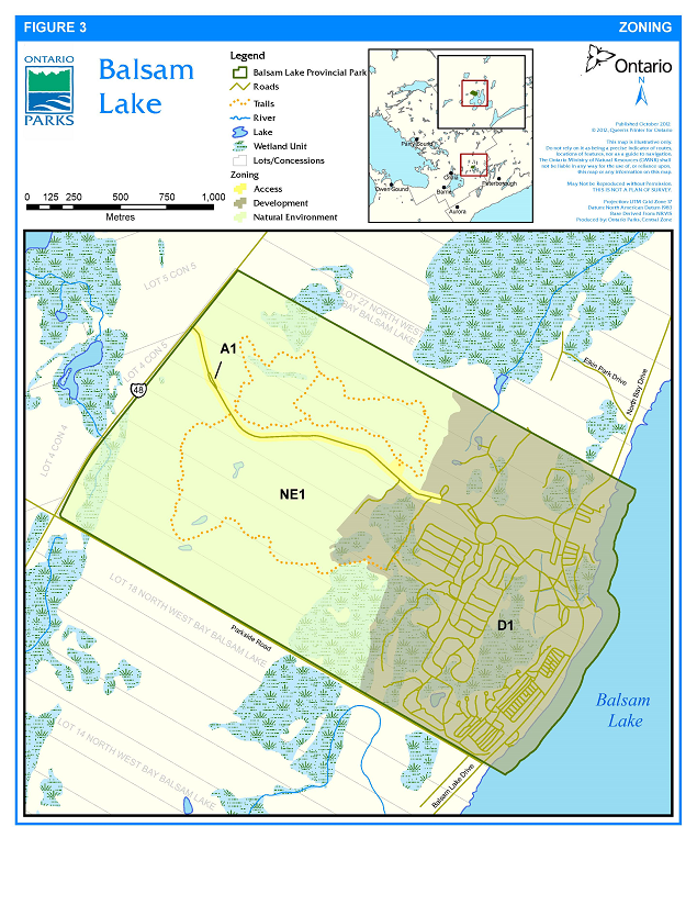
Lands within Balsam Lake Provincial Park are zoned in accordance with their environmental and cultural heritage values, and their need for protection (Figure 3). Zones differentiate the sensitivity of the natural and cultural values, and the permissible degree of development, recreational uses and management practices within the park.
Zoning categories and permitted activities in each type of zone are derived from the Ontario Provincial Parks: Planning and Management Policies (1992 update). The three zoning categories designated for Balsam Lake Provincial Park are development, access and natural environment.
8.1 Development zone
Development zones contain the area of the park that is geared towards the support of intensive day-use and camping activities. Development may include roads, visitor control structures, day-use facilities (e.g., beaches, picnic areas), car campgrounds, commercial service facilities, maintenance facilities and park offices, as well as orientation, interpretive, educational, research and management facilities (OMNR 1992).
Development zone D1 (199 ha)
This zone contains the facilities to support recreation activities including the campground area, day-use and beach areas (including lake bed where the park boundary extends into Balsam Lake), boat launch, comfort stations, all tile beds, picnic areas, and most parking areas and roads. This zone also includes the park office, administration buildings, park store and maintenance yard.
8.2 Access zone
Access zones serve as staging areas and a means of both providing and regulating use in areas of a park geared towards extensive recreation. Generally, development is limited to roads and visitor control structures. Provisions may be made for limited orientation, interpretive or educational facilities (usually self-use rather than through structured personal service). Limited facilities for research and park management may also be present (OMNR 1992).
Access zone A1 (9 ha)
This zone includes the main road entering the park from Highway 48 and the Plantation Trail parking area.
8.3 Natural environment zone
Natural environment zones include natural and cultural landscapes in which minimum development is permitted to support low-intensity recreational activities and protect significant natural and cultural features and values. Development is limited to trails, necessary signs and minimal interpretive facilities, and similar facilities which support low-intensity recreational use (OMNR 1992).
Natural environment zone NE1 (241 ha)
This zone contains a rolling and partially wooded landscape with a regionally significant esker-kame complex. The park’s hiking trails are located in this zone.
Figure 3: Zoning
9 Park policies
This section provides site specific management policies and any associated actions required to effectively manage Balsam Lake Provincial Park in accordance with the PPCRA, policies for recreational class parks and all other relevant legislation and provincial policies.
9.1 Industrial uses
Industrial activities are prohibited in Balsam Lake Provincial Park. Industrial activities include, but are not limited to: generation of electricity (with the exception of electrical generation for in-park use); prospecting, staking mining claims, developing mineral interests or working mines; and extracting aggregate, topsoil or peat, and commercial timber harvesting.
9.2 Commercial and private uses
Commercial harvesting, including trapping, fishing, and baitfish harvesting, is not permitted. There are no existing licences, and new operations will not be considered. The park is not located in a Bear Management Area.
There are no private or commercial land use permits, licences of occupation or leases in Balsam Lake Provincial Park. Private or commercial boat caches are not permitted.
9.3 Resource management policies
Balsam Lake Provincial Park will be managed in accordance with the policies set out in Ontario Provincial Parks: Planning and Management Policies (1992 update) for recreational class parks. All resource management projects will be undertaken consistent with A Class EA-PPCR and the ESA. The Ministry of Natural Resources and Forestry (MNRF) will consider adaptive management approaches when managing park resources.
Resource management initiatives may be undertaken through partnerships.
9.3.1 Land management
Landforms within the park will be managed for maintenance of natural processes and function, protection of significant natural, cultural and recreational features, and visitor safety.
Shoreline processes, including erosion, will be monitored (see Section 9.3.14) and may be controlled, where appropriate and feasible.
Erosion of the park’s shore bluffs is a natural dynamic process that gradually erodes the shoreline by the action of water, wind and ice. Some measures have been implemented in the lakeshore campgrounds (Ash, Oak and Elm) and day-use area to address shoreline erosion, including the planting of vegetative barriers, installing stone retaining walls along the edge of campsites, and providing trails and shore bluff stairs to focus use. Erosion of the shore bluffs may be controlled or minimized, and/or the shoreline stabilized by establishing native vegetation, ensuring appropriate setbacks from the shoreline for all facility site planning, controlling pedestrian impacts by using vegetative barriers and shore bluff stairs, installing retaining walls, or other methods.
Shoreline management measures may also be undertaken to minimize erosion of sand from the beach area. A shoreline geotechnical study was undertaken in 2016/17 to look at the causes of and possible solutions for managing beach sand erosion (WSP Canada Inc. 2017). Recommendations arising from this or future studies may be implemented, including engineered approaches such as improved and redirected sub-surface and surface drainage, constructed outflow areas and others. Additional actions to minimize potential erosion of sand from the dry beach area may be implemented, and may include hardscaping (e.g., ditches, swales, undulations in topography), re-vegetation of erosion-prone areas, increased sand particle size, temporary/seasonal fencing and other actions.
Opportunities for restoring ecological processes and fish and wildlife habitat will be considered in the development and evaluation of options. Vegetated shoreline buffers within the park and along the park boundary will be protected and enhanced wherever possible.
Six groynes are located along the shoreline in the day-use area to help control shoreline erosion; these groynes will be maintained or repaired as required. Removal or redesign of the groynes may also be considered, subject to geomorphological study of the shoreline and resulting recommended actions to restore natural process and/or protect park values.
The dry beach area (i.e., above the high water mark) will be maintained for recreational use, and replenished with sand as needed. The addition of sand will be in compliance with the federal Fisheries Act, 1985 and other relevant legislation and policy, and will be limited to areas above the high water mark.
All aggregate required for in-park use will be acquired from outside the park. Areas where aggregate is brought in will be monitored for alien and invasive species.
9.3.2 Water management
Balsam Lake is part of the Trent-Severn Waterway. The Trent-Severn Waterway is a series of interconnected waterways, canals and locks, built between 1833 and 1920, stretching for 386 km through southern and central Ontario, connecting Lake Ontario and Georgian Bay. Water levels and flows throughout the waterway are managed by Parks Canada, an agency of Environment Canada.
9.3.3 Alien and invasive species
Alien species are plants, animals and micro-organisms that have been unintentionally or deliberately introduced by human activity into areas beyond their normal range. Alien species will not be deliberately introduced into the park.
Invasive species are those species whose introduction or spread threatens the environment, the economy and/or society, including human health.
Where alien or invasive species threaten natural or cultural values, or human health, a control program may be undertaken if feasible and practical.
The Life Science Inventory of Balsam Lake and Indian Point Provincial Parks (Jalava 2007) and the Balsam Lake Provincial Park Vegetation Stewardship Plan (Korol 2006) should be referred to for specific direction relating to the management of alien and invasive species.
9.3.4 Extirpated native species
Extirpated native species may be reintroduced, and existing populations replenished, if biologically feasible and acceptable, and desirable for perpetuating park values.
9.3.5 Insects and diseases
Infestations of vegetative insects and diseases that are native to the region will normally be allowed to progress naturally. Insect and disease control measures for native and alien species may be implemented if the features and/or values of the park are threatened. Where control is undertaken, it will be directed as narrowly as possible to the specific insect or disease, so as to have minimal effects on the rest of the park’s environment. Non-chemical and species-specific controls will be used whenever possible. Infestations by insects and diseases may be monitored and assessed. Emergency measures may be implemented to protect the park’s features and values and would be subject to the appropriate MNRF approval.
9.3.6 Pesticide use
Mechanical and other non-chemical forms of vegetation removal will be the preferred alternative to chemical herbicides, and will be used wherever feasible. All herbicide use must be in accordance with park policy and the Pesticides Act.
9.3.7 Fire management
Ontario’s Wildland Fire Management Strategy (OMNRF 2014c) provides strategic direction for the management of wildfire across Ontario. According to this provincial strategy, Balsam Lake Provincial Park is located in the Northeast Fire Region where forest fire response and management is the responsibility of MNRF.
However, the City of Kawartha Lakes has negotiated a fire management agreement with the MNRF. In this agreement, Balsam Lake Provincial Park is located within the Municipal Protection Area; as such, the City of Kawartha Lakes has the primary responsibility for fire response. The MNRF will assist the City of Kawartha Lakes in fire response activities if required.
Fire has historically influenced the development of vegetation communities within Balsam Lake Provincial Park. A large and intense fire burned the region in the late 1860’s; however, there have been no major fires in the area in over 70 years (Korol 2006). Fire management within Balsam Lake Provincial Park will aim to restore and maintain ecological integrity while preventing personal injury, loss of values and social disruption. Fires that pose a threat to public health and safety, property and infrastructure, or other values are a priority for suppression. Fire evacuation procedures will be outlined in the emergency management plans and documents for Balsam Lake Provincial Park.
Prescribed burning to achieve ecological or hazard reduction objectives may be implemented within Balsam Lake Provincial Park. Plans for any prescribed burning will be developed in accordance with the MNRF Prescribed Burning Operations Policy, its associated planning manual, and A Class EA-PPCR in cooperation with Haliburton Fire Management Headquarters and/or the municipal fire department.
Fuel caches are not permitted in the park.
9.3.8 Species at risk
Species at risk and their habitats will be protected in a manner consistent with the ESA, associated regulations and guidelines.
Species listed on the SARO list in the special concern, threatened and endangered categories have been found in the park. Monitoring of these species is ongoing and will continue. Recovery strategies may be prepared in the future for species found in the park. Priorities and actions identified in any government response statements may be implemented in accordance with Ontario Parks’ policies.
9.3.9 Vegetation management
Balsam Lake Provincial Park will be maintained in as natural a state as possible. Management of vegetation within the park, including management of pine plantations, will be directed toward supporting the natural succession of vegetation communities.
Native plant species may be planted for the purpose of restoration, enhancement of existing natural areas, shoreline management, or rehabilitation of trails, roads, campsites or other disturbed areas. Where planting or seeding is necessary, use will be made exclusively of species native to the park and/or surrounding areas. Seeds and plants used in re-vegetation programs will be derived from sources which originate in or as near the park as possible. Tree species will be derived from within the same or adjacent seed zones, and all other species will be derived from the same or adjacent ecodistricts, wherever possible.
An area of the park has been converted to a tree nursery to grow seedlings for in-park restoration and landscaping projects. This nursery may be expanded.
Hazardous trees in close proximity to trails, campgrounds, facilities or roads will be removed if they pose a risk to public safety or park operations. Where possible, trees and brush cut in natural areas will be left to deteriorate in place.
Native vegetation may only be pruned where it interferes with authorized recreation activities or facility management (e.g., trail maintenance), to enable approved development, or to ensure public safety. Disturbed areas will be restored with native vegetation where practical and feasible. Naturalized areas and areas of native vegetation will be given a high priority for protection and will be buffered from development and recreational impacts to the greatest extent possible. Examples of buffering may include an increase in the size of the natural area, strategic planting of native species, fencing or natural barriers, and/or setbacks for development or recreation facilities.
For safety purposes, control or eradication of plants that are poisonous to humans by touch (e.g., poison ivy (Toxicodendron radicans), giant hogweed (Heracleum mantegazzianum)) may be undertaken. Where control is required, it will be directed as closely as possible to the specific problem plant species in locations where conflict is an identified concern (e.g., adjacent to campsites, the beach, or trails).
Standing, fallen or sunken trees which are removed for resource management or public safety purposes may be marketed or used by the park.
The Balsam Lake Provincial Park Vegetation Stewardship Plan (Korol 2006) and Life Science Inventory of Balsam Lake and Indian Point Provincial Parks (Jalava 2007) provide specific vegetation management recommendations and guidelines. These documents should be referred to for specific vegetation management prescriptions.
9.3.10 Wildlife management
Animal populations or individual nuisance/displaced animals may be controlled when necessary to maintain or improve human health and safety or the values for which the park has been established.
The reduction of hyperabundant populations (e.g., white-tailed deer (Odocoileus virginianus), wild turkey (Meleagris gallopavo), and raccoon (Procyon lotor)) may be undertaken if population numbers exceed the park’s carrying capacity. Ontario Parks will manage hyperabundant populations in the park at a level that the habitat can sustainably support based on the best available scientific information. If required, populations will be reduced as quickly as possible to within carrying capacity, and then maintained as required to keep population numbers stable.
Appropriate methods of animal control or population management, including lethal methods, will be undertaken directly by Ontario Parks or through partnerships under the strict supervision of Ontario Parks. Where control or management is necessary, techniques having minimal effects on the components of the park’s environment will be used.
Projects to enhance or restore native wildlife habitat will be considered and implemented where feasible and appropriate. Actions may include restoration or enhancement of natural areas, installation of habitat structures such as bird boxes and turtle nesting areas, and others.
9.3.11 Fisheries management
Balsam Lake has been historically stocked with smallmouth bass (Micropterus dolomieu), walleye (Sander vitreus vitreus), and muskellunge (Esox masquinongy); however, the lake has not been recently stocked. Stocking was conducted by the MNRF.
Ontario Parks will work jointly with provincial, regional and district MNRF staff to ensure that protected area objectives are met in fisheries management.
9.3.12 Cultural heritage resources management
The management of cultural heritage resources within Balsam Lake Provincial Park will be directed towards protection, and providing heritage appreciation and research opportunities. Cultural heritage resources that may be affected by any park projects and activities will be identified and managed (i.e., protected, maintained, used and/or disposed of) in accordance with MNRF’s Technical Guideline for Cultural Heritage Resources (2006) and other relevant cultural heritage documents.
All areas of archaeological potential that may be affected by any activities associated with park design investigations, construction, operation or maintenance will be assessed. Archaeological resources shall be identified and evaluated in accordance with the processes documented in the Standards and Guidelines for Consultant Archaeologists (MTC, 2011). Impacts may include any form of soil disturbance or alteration including testing, excavating, grading, capping and filling.
9.3.13 Research
The MNRF encourages scientific research by qualified individuals contributing to the knowledge of natural and cultural history and to environmental management. Ontario Parks will review proposed research to ensure adequate consideration of potential impacts on protected area resources, features, staff and visitors.
Research and monitoring activities require research authorization issued under the PPCRA, consistent with relevant policy. Research will be subject to development and management policies associated with the park’s classification, unless special permission is given. Research must meet all requirements under applicable provincial and federal legislation, and may require additional permits or approval (e.g., MNRF Wildlife Scientific Collector authorization or ESA permits).
Ontario Parks may allow temporary facilities in support of approved research and monitoring activities. Sites altered by research activities must be rehabilitated as closely to their previous condition as possible, except where the specific intent of the research activities is disturbance for the purpose of ecological enhancement or restoration.
9.3.14 Inventory and monitoring
Planning and management decisions are intended to ensure the ecological integrity of protected areas. Considerations will be given to social and economic components.
Ontario Parks will ensure that planning and management decisions are made with the best available information. Ontario Parks may conduct inventories and monitoring, as necessary, to provide this information; such efforts will be undertaken based on established methodologies and best practices.
Inventory and monitoring will foster an adaptive management approach to protected areas management.
Priority inventory and monitoring projects include, but are not limited to:
- monitor butternut population in conjunction with the Butternut Recovery Teams and the Natural Heritage Information Centre (NHIC)
- monitor effectiveness of activities detailed in the Balsam Lake Provincial Park Vegetation Stewardship Plan
- monitor invasive species; recommend and implement mitigation as required
- monitor shoreline processes including erosion; recommend and implement mitigation if necessary
- monitor campsites; recommend campsites for rehabilitation if necessary
- monitor trails for erosion and degradation; recommend and implement mitigation, trail closure, or relocation if necessary
- conduct further life science inventory as recommended in the life science inventory (Jalava 2007)
9.4 Recreation management policies
Balsam Lake Provincial Park will continue to offer camping facilities, roofed accommodation, day-use and recreation opportunities including picnicking, swimming, fishing, boating, hiking and wildlife viewing. Recreation management will seek to maintain the ecological integrity of the park and protect significant natural and cultural heritage features, while allowing opportunities for compatible outdoor recreation.
9.4.1 Services for visitors
Balsam Lake Provincial Park will continue to provide a number of services for park visitors including concession sales and rentals, as well as laundry facilities. Additional amenities and services may be provided if feasible and demand warrants (e.g., off-leash dog area).
9.4.2 Day-use area and boat launching, mooring and docking facilities
The day-use area and associated facilities are located in the southeast portion of the park.
Balsam Lake Provincial Park maintains a boat launch and limited docking facilities for boaters in possession of a valid camping or day-use permit; overnight docking by boaters without a valid camping permit is not permitted. See Section Section 9.7.3 for development policies relating to the day-use area and docking facilities.
No mooring facilities will be provided. The mooring of boats off-shore creates public safety concerns and potential damage to the water intake; the park will utilize signage and education to deter boaters from this practice. Boats are not permitted to tie to the park shoreline.
Adjacent to the beach area are two day-use parking lots which can accommodate a total of approximately 350 vehicles. There is separate parking available for boat trailers. See Section Section 9.7.2 for policies related to parking area development.
The park may be closed to further day-use visitors once the vehicle capacity of the parking areas is reached, or at the discretion of the park superintendent.
9.4.3 Fees
Fees are collected in accordance with the Ontario Parks fee schedule for overnight and day-use access to the park and facilities. Fees are currently collected for camping, day-use, roofed accommodation and picnic shelter reservations.
Fees may be collected for use of the park’s docking facilities.
Fees will be collected for trailer storage should a secure parking area be developed for this purpose (see Section 9.7.2).
9.4.4 Winter use
Winter recreational use is currently limited to self-use activities such as walking, snowshoeing and cross-country skiing. Motorized snow vehicles
Park services and facilities (e.g., washrooms, warm up areas, and trail grooming) are not currently provided. Winter camping is not currently permitted. Formalized winter operations, including winter camping, may be provided if demand warrants and resources allow.
Winter use of roofed accommodation facilities may be permitted in the future if demand warrants and resources allow.
9.4.5 Hunting
Recreational hunting is not permitted, consistent with regulations under the Fish and Wildlife Conservation Act, 1997 (FWCA).
9.4.6 Recreational fishing
Recreational fishing is subject to provincial and federal fisheries regulations (e.g., the FWCA and the Fisheries Act, 1985 (Canada)), as set out in the Ontario Recreational Fishing Regulations Summary.
Fishing in the buoyed swimming areas is prohibited.
9.4.7 Mechanized travel
All-terrain vehicles (ATVs)
Currently, motorized snow vehicles are permitted on authorized park roads only. The park superintendent may prohibit the use of motorized snow vehicles, should their use cease to be compatible with changing winter use of the park, or to prevent degradation of or damage to park values.
The park superintendent may authorize the use of ATVs and/or other vehicles, including motorized snow vehicles, for management, monitoring or emergency purposes.
Bicycles are permitted on park roads, but are not currently permitted on the Lookout Tower or Plantation hiking trails. The use of bicycles on the Plantation Trail may be considered, and permitted if effects to ecological values and other recreational users can be appropriately mitigated.
9.4.8 Trails
There are two interpretive hiking trails within the park, Lookout Trail and Plantation Trail; these trails are connected by a secondary trail called Lorrie’s Link:
- Lookout Trail (2.6 km) meanders along an esker and through a cedar swamp, deciduous forest and open meadow.
- Plantation Trail (4.2 km) explores the impact of human activities on the land over the last 150 years. The trail passes through former logging sites, old farm fields and reforestation plantations.
The Lakeshore Trail runs along the shoreline of Balsam Lake Provincial Park. It provides pedestrian access from the lakeshore campgrounds to the day-use area including the boat launch, boat rental and beach.
In order to alleviate demand for parking spaces in the day-use area, a network of trails has been developed linking the day-use area with the campgrounds. Campers are encouraged to park on their campsites or in campground parking lots and use this network of trails to reach the day-use area.
Authorized trails will be maintained and will be monitored for erosion and degradation. If necessary, trails or sections of trails may be closed or relocated to prevent further erosion, trampling, rutting, widening, or other degradation of park values. See Section Section 9.7.6 for development policies related to trails.
9.4.9 Roofed accommodation
The park currently offers a fully-furnished four bedroom cottage for rent during the operating season. The cottage is located southwest of the boat launch area in the development zone.
A staff house, located in the development zone and accommodating 14 people, is used during the spring and summer (May to September). If feasible and demand warrants, the park superintendent may rent this facility to park visitors during the shoulder seasons, or during peak season if it is no longer required to house park staff.
See Section 9.7.5 for development policies related to roofed accommodation.
9.4.10 Other recreational uses
The park superintendent will use existing legislation, park policy and interim guidelines to manage emerging or other recreational uses for which there is either limited or no current provincial policy to direct their management.
9.5 Operations policies
A park operations plan will provide park staff with the necessary direction to operate the park on a day to day basis. In addition to addressing the operations policies in the following sections, the park operations plan will include such topics as budget, staffing, maintenance schedules, enforcement, and emergency services.
The provisions of the park operations plan will be consistent with park policy and the approved Ontario Provincial Parks Operating Standards, and will be reviewed annually and updated as required.
9.5.1 Education
Provincial parks have a role in supporting the heritage appreciation objective in the PPCRA. The manner in which that objective is met will vary for each park and may be adapted based on the park’s resources and MNRF’s direction and priorities at the time.
Balsam Lake Provincial Park presently offers a variety of interpretive programs and products.
Balsam Lake Provincial Park’s Natural Heritage Education (NHE) program provides structured events for park visitors in keeping with the interpretive and educational themes that have been established for the park. The park also supports and encourages unstructured recreational activities; for example, hiking trails are available to those wishing to explore the park.
An education plan has been developed and will be updated as required.
9.5.1.1 Information
Information about the park, facilities, services, and points of interest in the greater region will be provided to park visitors. A variety of media will be used to convey this information including the park information tabloid, Ontario Parks publications, the Ontario Parks website, signs, bulletin boards, displays and personal contact. Information will be available at the permit office, administrative office and other locations throughout the park.
9.5.1.2 Park interpretation
Interpretive programs and facilities provide park visitors with a greater appreciation for and understanding of the natural and cultural features of Balsam Lake Provincial Park.
Interpretive themes for the park include, but are not limited to:
- Cultural history of the area surrounding Balsam Lake
- Trent-Severn Waterway
- Geology of the park including the esker-kame complex
- Ecology of the Great Lakes St. Lawrence Lowlands-Canadian Shield Transitional Zone
For further direction on park education and programming, refer to the strategic direction for education in Ontario Parks and additional park specific education plans.
9.5.2 Partnerships
In the implementation of the park management plan, Ontario Parks may pursue opportunities for partnerships involving other agencies and groups through formal partnership agreements. Partners may represent the local community, and local and provincial interests. Partners will work with Ontario Parks to assist in the implementation of the park management plan and will follow provincial park policies and regulations.
9.6 Marketing and communications policies
9.6.1 Marketing
Balsam Lake Provincial Park will be operated consistent with the overall marketing strategy of Ontario Parks. Marketing may include promoting the park on the basis of its natural and cultural heritage values and recreational opportunities, and appropriate enjoyment and appreciation of those values and opportunities.
9.6.2 Communications
Information about the park will be made available to the public through a variety of means including the Ontario Parks website, park information tabloid, Ontario Parks Guide, and on-site at Balsam Lake Provincial Park.
9.7 Development policies
Development will proceed in accordance with the Class EA-PPCR, ESA, OHA, other applicable provincial legislation and policies, and the following direction. All development undertaken by Ontario Parks or by concessionaires on its behalf will be carried out in accordance with approved site and development plans that meet development standards for provincial parks.
Areas proposed for development will be assessed for significant cultural heritage resources and natural values, such as species at risk, to ensure these values are identified and protected. Alternatives will be considered to ensure that sites selected for development have the least impact on natural and cultural heritage values. Consideration will be given during site planning to ensure appropriate setbacks from shorelines.
Aging park facilities and infrastructure (e.g., water distribution lines, sewage tile fields, electrical lines, buildings and shelters) will be upgraded, repaired, replaced, removed or decommissioned as required.
9.7.1 Internal roads
To address public safety concerns and improve traffic flow, parks roads may be widened or reconfigured to establish dedicated bike and pedestrian lanes.
Some park roads may be closed and rehabilitated, while others are widened and/or rerouted, to consolidate the park’s road network which will improve the park’s ecological integrity.
A portion of North Bay Drive passes through the regulated boundary of the park, and was historically used during the non-operating season to provide access for local through traffic. This section of road is now closed to through traffic but will continue to be used for park purposes.
The section of road around the park store may be upgraded (e.g., straightened, widened) and/or rerouted to improve traffic flow and better accommodate vehicles with trailers and other traffic. This road provides direct access to the boat launch and day-use area from the main park entrance as well as access to the lakeshore campgrounds (Ash, Oak and Elm) and Hawthorn Campground. The park store parking area may be reconfigured to permit these changes.
9.7.2 Parking areas
Existing parking areas will be maintained or upgraded as required. Existing parking areas may be expanded or new parking areas developed in the development or access zones should an increase in demand warrant additional parking space. If additional parking is deemed necessary it will be developed with consideration for ecological values. Parking areas which are underused, no longer required for their intended purpose, or threaten ecological values may be closed and rehabilitated.
A trailer storage parking lot may be developed near the maintenance area in the development zone. This lot will provide a secure area for park users to leave their trailers while not in use.
9.7.3 Day-use area and docking
The docking facilities in the day-use area will be maintained and may be replaced or expanded to improve functionality. The boat launch and retaining wall may be upgraded or replaced as necessary.
Existing playgrounds may be relocated or upgraded, and additional playgrounds may be constructed in the development zone.
The park amphitheatre may be repaired or upgraded and may be relocated to the day-use area, to increase accessibility and visitor use.
Vault privies located near the beach area may be upgraded and/or replaced with a comfort station. See Section 9.4.2 for recreation management policies related to the day-use area and docking facilities.
9.7.4 Campgrounds and campsites
Campsites and group campsites may be closed where they are consistently underused, pose user conflicts, or result in undue damage to the environment. Buffers between campsites may be enhanced.
Additional picnic shelters may be constructed if demand warrants.
Electrical service may be provided to currently unserviced campsites.
Comfort stations and vault privies will be maintained, upgraded or replaced as required.
9.7.5 Roofed accommodation
Additional roofed accommodation (including yurts, rustic, standard or premium cabins, or other types of structures) may be constructed in the development zone, if feasible and demand warrants. Roofed accommodation facilities may be built on existing campsites, or existing campgrounds may be expanded or reconfigured to accommodate roofed accommodation facilities.
The cottage and staff house may be replaced or upgraded as required.
9.7.6 Trails
An observation tower providing a view of Balsam Lake and the surrounding countryside may be constructed along the Lookout Trail.
New interpretive trails may be considered if compatible with ecological protection and heritage appreciation objectives.
Dedicated bicycle and pedestrian routes (lanes on park roads or new trails) will be considered and may be implemented in conjunction with other projects, such as road work, or where the opportunity arises.
The Lakeshore Trail, which includes a section of an old park road, will be upgraded to become to an accessible trail.
See Section 9.4.8 for recreation management policies related to trails.
9.7.7 Maintenance and administrative areas
Several park administrative buildings may be consolidated and replaced with one administrative centre. This would reduce maintenance requirements and the ecological footprint of park infrastructure, as well as improve operational and staffing efficiency.
Buildings no longer serviceable will be demolished and the sites allowed to regenerate naturally. Restoration at these sites may be undertaken. Buildings that are still serviceable may be used for other park purposes.
The trailer sanitation station may be upgraded, replaced or expanded as required which may include road reconfiguration.
9.7.8 Generation of electricity for in-park use
Small-scale facilities to generate electricity for in-park use may be developed (e.g., solar panel(s) to supply a park building or other infrastructure, such as a light).
10 Implementation priorities
Park development, operations and resource management will be contingent upon the availability of funding and unforeseeable changes in priorities or policy. Implementation of the management plan and operation of the park will meet the requirements of the PPCRA and all other pertinent legislation and policies.
Projects will be phased in as resources permit and may include the following:
Phase 1 (short term)
- implement recommendations for erosion management in the beach area (Section 9.3.1)
- upgrade Lakeshore Trail to meet accessibility standards (Section 9.7.6)
- implement recommendations from the Balsam Lake Provincial Park Vegetation Stewardship Plan (Sections 9.3.3, 9.3.9 and 9.3.14)
- upgrade and/or improve design of the section of road around the park store to improve traffic flow (Section 9.7.1)
- widen or reconfigure park roads to establish dedicated bike and pedestrian lanes (Sections 9.7.1 and 9.7.6)
- implement recommendations relating to Species at Risk management, as appropriate (Section 9.3.8)
- maintain and replenish the dry beach area as needed (Section 9.3.1)
- consolidate the park’s road network to improve the park’s ecological integrity (Section 9.7.1)
- conduct monitoring activities and implement recommendations derived from results, as appropriate (Section 9.3.14)
Phase 2 (medium term)
- upgrade or replace vault privies and other park infrastructure as needed (Sections 9.7.3 and 9.7.4)
- identify, assess and manage the park’s known and potential cultural heritage resources (Section 9.3.12)
- maintain or repair groynes as required (Section 9.3.1)
- evaluate the demand for and feasibility of:
- based on the results of feasibility evaluations - construct roofed or alternative accommodation, develop new parking area for trailer storage, and/or expand electrical service as warranted (Sections 9.7.5, 9.7.4 and 9.7.2)
- implement shoreline or bank stabilization measures as required (Section 9.3.1)
- upgrade, replace or expand trailer sanitation station (Section 9.7.7)
Phase 3 (long term)
- relocate amphitheatre to the day-use area (Section 9.7.3)
- construct additional playground(s) in the development zone (Section 9.7.3)
- construct new administrative centre to replace several administrative buildings (Section 9.7.7)
11 Examination and adjustment of management direction
This management plan will be examined in accordance with the provisions of the PPCRA to determine whether it is still relevant, effective and current or if adjustments are needed. In circumstances where the plan provides insufficient direction, or to address specific issues or pressures, it may be examined prior to the next scheduled examination.
External requests for amendments to address specific proposals or needs may be considered. Ontario Parks can provide further guidance on the process for requesting an amendment and whether specific requests can/will be considered.
12 References
Burns, J.A. 1972. Archaeological Survey of Balsam Lake Provincial Park, Bexley Township, Victoria County, Ontario. Ontario Ministry of Natural Resources.
Fire Protection and Prevention Act, 1997.
Fish and Wildlife Conservation Act, 1997.
Horizon Archaeology. 2007. Stage One Archaeological Assessment for Balsam Lake Provincial Park, Bexley Township, ON. Prepared for Michael Green, Superintendent, Balsam Lake Provincial Park.
Jalava, J. V. 2007. Life Science Inventory of Balsam Lake and Indian Point Provincial Parks. Prepared for Ontario Parks, Central Zone, Huntsville, Ontario.
Kawartha Lakes Fisheries Assessment Unit. 1999. Balsam Lake Nearshore Community Index Netting. Ontario Ministry of Natural Resources, Update 1999-4.
Kawartha Lakes Fisheries Assessment Unit. 2000. 1999 Balsam Lake Open Water Angler Survey. Ontario Ministry of Natural Resources, Update 2000-1.
Kawartha Lakes Fisheries Assessment Unit. 2002. Balsam Lake 2002 Open Water Angler Survey. Ontario Ministry of Natural Resources, Update 2003-3.
Kawartha Lakes Fisheries Assessment Unit. 2003. Balsam Lake 2003 Open Water Angler Survey. Ontario Ministry of Natural Resources, Update 2004-1.
Korol, J.B. 2004. Research and Information Strategy, Ontario Parks, Central Zone (2004-2009). A report prepared for the Central Zone Office, Ontario Parks, Huntsville.
Korol, J.B. 2006. Balsam Lake Provincial Park Vegetation Stewardship Plan. A report prepared for the Ontario Parks Central Zone office, Huntsville.
Korol, J.B. 2007. Ecological Monitoring Strategy, Ontario Parks, Central Zone (2007-2012). A report prepared for the Central Zone Office, Ontario Parks, Huntsville.
MacDonald, Ian D. 1982. A Reconnaissance Biological Inventory of Balsam Lake Provincial Park. Ontario Ministry of Natural Resources.
McMurty, M.J., W.D. Bakowsky, S.R. Brinker, C. D. Jones, M.J. Oldham and D.A. Sutherland. 2008. Life Science Reconnaissance of Selected Sites in The Land Between, Final Report. Natural Heritage Information Centre, Ontario Ministry of Natural Resources, Peterborough, Ontario.
Motorized Snow Vehicles Act, 1990.
Natural Heritage Information Centre. 2005. Element Occurrence and Natural Areas. Natural Heritage Information Centre, Ontario Ministry of Natural Resources Peterborough, Ontario. Electronic databases.
Ontario Ministry of Natural Resources. 1980. Balsam Lake Provincial Park Preliminary Master Plan.
Ontario Ministry of Natural Resources. 1983. Lindsay District Land Use Guidelines. Queen’s Printer for Ontario.
Ontario Ministry of Natural Resources. 1984. Balsam Lake Provincial Park Management Plan – Background Information Document.
Ontario Ministry of Natural Resources. 1985. Balsam Lake Provincial Park Management Plan.
Ontario Ministry of Natural Resources. 1992. Ontario Provincial Parks: Planning and Management Policies. Queen’s Printer for Ontario.
Ontario Ministry of Natural Resources. 2001. Ontario Parks Park User Survey, Camper Statistical Summary 2000. Peterborough: Planning and Research Section, Ontario Parks.
Ontario Ministry of Natural Resources. 2005a. Protecting What Sustains Us: Ontario’s Biodiversity Strategy. Queen’s Printer for Ontario.
Ontario Ministry of Natural Resources. 2005b. Our Sustainable Future: Ministry of Natural Resources Strategic Direction. Queen’s Printer for Ontario.
Ontario Ministry of Natural Resources. 2005c. A Class Environmental Assessment for Provincial Parks and Conservation Reserves. Queen’s Printer for Ontario.
Ontario Ministry of Natural Resources. 2006a. Ontario Parks User Survey, Camper Statistical Summary – 2005. Peterborough: Planning and Research Section, Ontario Parks.
Ontario Ministry of Natural Resources. 2006b. Technical Guideline for Cultural Heritage Resources for Projects Planned under the Class Environmental Assessment for MNR Resource Stewardship and Facility Development Projects and the Class Environmental Assessment for Provincial Parks and Conservation Reserves.
Ontario Ministry of Natural Resources. 2010. Species at Risk in Ontario List.
Ontario Ministry of Natural Resources. 2011a. Ontario’s Biodiversity Strategy: Renewing our Commitment to Protecting What Sustains Us. Queen’s Printer for Ontario.
Ontario Ministry of Natural Resources. 2011b. Our Sustainable Future; a Renewed Call to Action, Ministry of Natural Resources Strategic Directions. Queen’s Printer for Ontario.
Ontario Ministry of Natural Resources. 2014a. Ontario Protected Areas Planning Manual: 2014 Edition. Peterborough. Queens Printer for Ontario. 33pp.
Ontario Ministry of Natural Resources. 2014b. Research Authorization for Provincial Parks and Conservation Reserves. PAM 13.01.
Ontario Ministry of Natural Resources and Forestry. 2014c. Wildland Fire Management Strategy. Toronto: Queen’s Printer for Ontario.
Ontario Ministry of the Environment. 1971. The Ontario Water Resources Commission Report on Water Quality in Balsam Lake.
Ontario Ministry of Tourism and Culture. 2010. Standards and Guidelines for Conservation of Provincial Heritage Properties.
Ontario Ministry of Tourism and Culture. 2011. Standards and Guidelines for Consultant Archaeologists.
Ontario Parks. 2007. Park Statistics 2006. Ontario Ministry of Natural Resources.
Ontario Parks. 2008. Park Statistics 2007. Ontario Ministry of Natural Resources.
Ontario Parks. 2009. Park Statistics 2008. Ontario Ministry of Natural Resources.
Ontario Parks. 2010. Park Statistics 2009. Ontario Ministry of Natural Resources.
Panel on the Future of the Trent-Severn Waterway. 2008. It’s all About the Water.
Parks Canada. 2007. Trent Severn National Historic Site of Canada.
Provincial Parks and Conservation Reserves Act, 2006.
WSP Canada Inc. 2017. Balsam Lake Provincial Park Beach Erosion Investigation. Peterborough.
13 Appendix 1: Summary of involvement
Summary and results of Indigenous involvement
Curve Lake First Nation, the Chippewas of Rama First Nation, the Chippewas of Georgina Island First Nation and Kawartha Nishnawbe each received an information letter and invitation to participate prior to the beginning of the planning process in 2007 and again in 2008 for the release for the terms of reference. Additionally, these communities, and the Williams Treaties First Nations Coordinator, received a notice at the preliminary management plan stage in 2013.
Two Indigenous communities responded during the preliminary management planning stage regarding Indigenous history wording and concern for the remains of Indigenous ancestors. Sections 3 and 7.1.3 of the management plan have been updated to reflect this response.
The seven Williams Treaties First Nations and Kawartha Nishnawbe were sent a notification letter upon the release of the approved management plan in March 8, 2018.
Summary and results of public and stakeholder involvement
Phase 1 – Invitation to participate; release of the terms of reference and background information file
The first phase of public consultation was an invitation to participate, including an opportunity to view the terms of reference and comment on the background information file for a joint management planning process for Balsam Lake and Indian Point Provincial Parks. This information was delivered through a direct mail-out to local landowners, stakeholders, interest groups and Ontario Parks’ mandatory contact list. Additionally, notices were placed in The Kawartha Lakes This Week newspaper, on the Ontario Parks website, and on the Environmental Registry. This opportunity to comment lasted for 45 days from November 24, 2008 to January 8, 2009. Six comments were received during this phase of the joint park management planning process. Of the six comments received, four related to Balsam Lake Provincial Park, one focused on Indian Point Provincial Park only and one letter was received requesting removal from the mailing list. The four Balsam Lake Provincial Park comments focused on various topics such as land use and cultural heritage resources management, animal control, and the overall ecological integrity of the park. Included in the four comments were recommendations of additional documents to be considered in the development of the preliminary management plan.
Comments were addressed in the preliminary management plan as follows:
- Ecological integrity and environmental resources of the park have been addressed through direction relating to the protection of existing natural areas; land, vegetation and wildlife management; facility site planning; and shoreline protection.
- Focused consultation has occurred with stakeholder groups, and further opportunities for consultation were provided at the release of the preliminary management plan, and in accordance with the Class EA-PPCR and other provincial policy.
- Additional documents were reviewed, and information from these documents was considered in the development of the preliminary management plan.
- The improvement and renewal of facilities such as parking areas, docks, groynes and buildings has been enabled.
- Research and monitoring priorities are addressed and enabled to ensure planning and management decisions are made with the best available knowledge and information to ensure ecological integrity.
- The protection of cultural heritage resources is addressed through MNRF and Ministry of Tourism, Culture and Sport guidelines and policies.
Phase 2 – Release of the preliminary management plan
The release of the preliminary management plan provided an opportunity for interested stakeholders and the public to review and comment on management policies and activities proposed for Balsam Lake Provincial Park. This information was delivered through a direct mail-out to adjacent landowners, local stakeholders and the Ontario Parks mandatory contact list. Additionally, notices were placed in The Kawartha Lakes This Week newspaper, on the Ontario Parks website, and on the Environmental Bill of Rights Environmental Registry. This opportunity to comment lasted for 45 days from March 8, 2013 to April 22, 2013. Three comments were received from the public and stakeholders regarding beach management, winter road maintenance, primary fire response, cultural heritage resources, and hunting.
Comments have been addressed in the management plan as follows:
- Shoreline management measures to minimize beach erosion have been added to the plan (see Section 9.3.1). A shoreline geotechnical study was undertaken in 2016/17.
- North Bay Drive has been closed to through traffic. Municipal winter use and maintenance of this road has been discontinued. The final plan has been updated to reflect this change (see Section 9.7.1).
In addition, changes have been made to the plan to ensure consistency with current legislation and provincial policy, support the maintenance and restoration of ecological integrity, and provide more clarity on development policies.
Phase 3 – Release of the approved management plan
The approved Balsam Lake Park Management Plan was released to the public on March 8, 2018. A policy decision notice associated with the approved park management plan was posted on the Environmental Registry. Indigenous communities, adjacent landowners, local stakeholders and the Ontario Parks mandatory contact list were notified of the release of the approved park management plan. Notification was also sent to people who submitted comments or requested to be added to the project mailing list. The approved management plan is available on the Ontario.ca website.
Ontario Parks will retain on file reference copies of the terms of reference, background information, preliminary management plan and the approved management plan.
Additional copies of this publication are available from the Ministry of Natural Resources and Forestry from:
Balsam Lake Provincial Park
RR#1, Hwy. 48
Kirkfield, ON
K0M 2B0
62953 (Print)
62954 (HTML)
ISBN 978-1-4606-7583-0 (Print)
ISBN 978-1-4606-7584-7 (HTML)
Footnotes
- footnote[I] Back to paragraph Defined in the Motorized Snow Vehicles Act, R.S.O. 1990. c. M. 44, s. 1.
- footnote[II] Back to paragraph Defined in the Provincial Parks and Conservation Reserves Act, 2006. O. Reg. 347/07.