Basswood Lake Hemlock Conservation Reserve Management Statement
This document provides policy direction for the protection, development and management of the Basswood Lake Hemlock Conservation Reserve and its resources.
Statement of Conservation Interest
Ministry of Natural Resources
Sault Ste. Marie District
Northshore Area
February, 2004
Ce document est seulement disponsible en anglais.
Approval Statement
I am pleased to approve this Statement of Conservation Interest (SCI) for Basswood Lake Hemlock Conservation Reserve (C256).
Basswood Lake Hemlock Conservation Reserve protects hemlock forests that are approaching old growth status. Regulated on December 7, 2002, this 104 hectare conservation reserve is situated in Day Township, approximately 15 kilometres northeast of the Town of Thessalon.
Direction for establishing, planning and managing conservation reserves is defined under the Public Lands Act, the Ontario’s Living Legacy Land Use Strategy, and other applicable policies. The specific direction for managing this conservation reserve is in the form of a basic SCI, which defines the area to which the plan applies, provides the purpose for which the conservation reserve has been established, and outlines the Ministry of Natural Resources' management intent for the protected area. This SCI has been created with input from program specialists within Sault Ste. Marie District. It will provide both the foundation for the continued monitoring of activities and guidance for the management of the conservation reserve. More detailed direction at this time is not anticipated. However, should significant facility development be considered or complex issues arise requiring additional studies, more detailed management direction in the form of special protection measures, or a detailed Resource Management Plan, will be prepared with full public consultation.
Public and Aboriginal consultation occurred prior to the regulation of this conservation reserve. An additional 15–day consultation period took place in December 2003 that provided stakeholders with an opportunity to comment on the draft SCI. Comments from the review period have been considered in the development of this document.
The management guidelines outlined in this SCI will be implemented by the Northshore Area Supervisor, and will be reviewed every five years and amended as required by the District Planner, Sault Ste. Marie District, Ministry of Natural Resources.
Written by:
Marjorie Hall
OLL Planner
Date: February 2, 2004
Submitted by:
Erin Nixon
District Planner
Date: February 3, 2004
Recommended for Approval by:
Dick Hagman
Northshore Area Supervisor
Signed on: February 12, 2004
Recommended for Approval by:
Serge Tenagila R.P.F.
District Manager, Sault Ste. Marie District
Dated: February 19, 2004
Approved By:
Rob Galloway
Regional Director, Northeast Region
Dated: April 2, 2004
1.0 Introduction
The following document is a Statement of Conservation Interest (SCI) for Basswood Lake Hemlock Conservation Reserve (C256). The purpose of this SCI is to identify and describe the natural, recreational, and cultural values of Basswood Lake Hemlock Conservation Reserve and to outline the Ministry of Natural Resources' management intent for this area. The first three sections of this document highlight the provincial context in which it was produced, state its goal and objectives, and summarize the planning process for conservation reserves. Sections4 through 7 are specific to Basswood Lake Hemlock Conservation Reserve and provide background Information and management direction for the site. Section 8 outlines the requirements for continued implementation and review of this document.
Management direction specified in this SCI will serve to protect the conservation reserve for the benefit of all Ontario residents. This direction will comply with the land use intent stated in the Ontario’s Living Legacy Land Use Strategy (LUS) (OMNR 1999) and associated policy clarification statements. Additionally, this conservation reserve will be managed under the Public Lands Act (OMNR 1997a), and will comply with all legal requirements as specified under the Environmental Assessment Act (R.S.O. 1990, Chapter E.18).
1.1 Provincial Context
Ontario’s network of natural heritage areas has been established to protect and conserve areas representative of the diversity of the natural regions of the province, including the species, habitats, features, and ecological systems which comprise that natural diversity. Protected natural heritage areas are a key component in the sustainable management of natural resources. They ensure that representative sites within the larger managed landscape are retained in as natural a state as possible.
On July 16, 1999, the LUS (OMNR 1999) was released to guide the planning and management of much of Ontario’s Crown lands. Extensive consultation was conducted during the development of the LUS (OMNR 1999). The objectives of the LUS (OMNR 1999) are to complete Ontario’s system of parks and protected areas; recognize the land use needs of the resource-based tourism industry; provide forestry, mining and other resource industries with greater certainty around land and resource use; and, enhance hunting, angling and other Crown land recreational opportunities (OMNR 1999).
The LUS (OMNR 1999) contributes to completing Ontario’s system of protected natural heritage areas by designating 378 new areas to be protected. These areas are considered to be significant and require protection from incompatible activities in order for their values to endure over time. Basswood Lake Hemlock Conservation Reserve forms part of Ontario’s network of natural heritage areas. It protects eastern hemlock (Tsuga canadensis (L.) Carr.) mixedwood forest stands that are approaching old growth status, which for hemlock in the Great Lakes St./Lawrence region is 140 years (King and Longyear 2003).
The Ministry of Natural Resources has established conservation reserves as a tool to protect natural heritage areas on public lands, while permitting most traditional public land uses to continue. These uses include recreational activities, such as hunting and fishing, and the traditional activities of Aboriginal communities as defined under applicable Aboriginal treaties. Lands designated as conservation reserves in the LUS (OMNR 1999) are removed from the Sustainable Forest License area, and mining and surface rights are withdrawn from staking under the Mining Act (RSO 1990 Chapter M.14).
The LUS (OMNR 1999) and subsequent policy clarification statements outline the general land use policy and management direction for new conservation reserves. Each new conservation reserve will have a planning document, either a SCI or, in more complex situations, a Resource Management Plan, that details site–specific management direction.
2.0 Goal and Objectives of the SCI
2.1 Goal
The goal of this SCI is to provide the framework and the direction to guide management decisions affecting Basswood Lake Hemlock Conservation Reserve.
2.2 Objectives
The following objectives are identified as the means to achieve the above stated goal:
- To describe the site’s current state of the resource in terms of its values and existing uses and activities
- To outline the Ministry of Natural Resources' management intent for the protected area
- To determine the land use compatibility of current land uses, and to develop specific guidelines and prescriptions to manage these uses
- To create public awareness of the values within this conservation reserve by providing information on the resources it contains and protects, and to support responsible stewardship through partnerships with local stakeholders
- To identify research, client services, and/or marketing strategies that may contribute to sound long–term management of the conservation reserve.
- To identify the monitoring and/or research necessary to maintain the integrity of protected values
- To provide direction for the evaluation of proposed new uses or economic ventures through the application of the Test of Compatibility (see Appendix B) and applicable Environmental Assessment Act legislation. This test will evaluate the impact of suggested use(s), either positive or negative, on the protected values of the conservation reserve
3.0 Management Planning
3.1 Planning for a Conservation Reserve
The planning process for a conservation reserve consists of regulating the site and preparing a site specific management plan. Consultation with the public, Aboriginal communities, and industry occur during site identification, boundary finalization, and management planning. Regulation of a conservation reserve involves preparing a legal description of the site boundaries, removing the site from the Sustainable Forest Licence area, and withdrawing the site from staking under the Mining Act (RSO 1990 Chapter M.14). Once a conservation reserve is regulated, the level of management planning required to fulfill the protection targets is determined, and either a basic or enhanced SCI or a Resource Management Plan is prepared.
A basic SCI is prepared when there is no deviation from the land use direction provided in the LUS (OMNR 1999) and there are few to no issues that require resolution. Alternatively, a Resource Management Plan (RMP) is prepared in situations where one or more complex issues have to be addressed, or where there is widespread public interest in a site. An enhanced SCI is an intermediary document which is used when a site requires more detailed management direction than would be provided by a basic SCI, but does not have issues significant enough to warrant the preparation of a RMP. Whichever the determination, the plan must be completed within three years of the conservation reserve’s regulation date. The guidelines for the preparation of these documents are provided in Procedural Guidelines A Resource Management Planning (Conservation Reserves Procedure PL3.03.05, Public Lands Act, OMNR 1997a) and the Northeastern Region Guidelines on the Planning Process for Conservation Reserves: Statement of Conservation Interest and Resource Management Plan (Thompson 2001).
A SCI is essentially a management plan, which receives its direction from the LUS (OMNR 1999). The purpose of a SCI is to identify the state of the resource in terms of the site’s values and its current land use activities, and to outline the Ministry of Natural Resources' management intent for the conservation reserve. Basic SCIs typically have a 15–day public consultation period, whereas enhanced SCIs and RMPs have a longer consultation period. Upon completion of this public review, the SCI, or RMP, is revised as necessary and approved by the appropriate Regional Director.
Existing permitted uses within conservation reserves may continue, unless they are shown to have a significant negative impact on the values protected by the site. A review/evaluation mechanism is in place to address proposed new permitted uses or land use proposals. The Test of Compatibility (see Appendix B) as outlined in the Public Lands Act Policy PL 3.03.05 (OMNR 1997a), and/or other standard Ministry of Natural Resources' environmental screening processes, are used to screen future proposals. Where cultural resources may be impacted, proposals may be screened through Conserving a Future for our Past: Archaeology, Land Use Planning & Development in Ontario Section 3 (MCzCR 1997).
Public comment may be solicited during a review of any future land use proposals that require new decisions to be made. Appropriate Environmental Assessment Act (R.S.O. 1990, Chapter E.18) requirements and amendment processes will apply to any future proposal and/or any significant change in management direction being considered for a site.
3.2 Planning Process for Basswood Lake Hemlock Conservation Reserve
Basswood Lake Hemlock Conservation Reserve was proposed as a conservation reserve in the LUS (OMNR 1999). Consultation has occurred with the public, Aboriginal communities, and industry. The boundary of the site was regulated through an amendment to Ontario Regulation 805/94 of the Public Lands Act on December 7, 2002, by Ontario Regulation 313/02. A copy of public consu0111tation documents can be found in Appendix D.
To date, no significant issues related to land use in this area have been identified. For this reason, it was determined that a basic SCI will adequately identify the site’s significant features and serve as the appropriate format for providing management guidelines. It should be noted that this document addresses only those issues or land use proposals currently known to the District Manager. The direction provided by this SCI, and future management decisions, will work to resolve any potential land use conflicts and to ensure that identified values continue to be adequately protected.
3.2.1 Planning Area
The planning area for this SCI consists solely of the regulated boundary for Basswood Lake Hemlock Conservation Reserve (see Appendix A, Map 1). However, to fully protect values within the conservation reserve, the area beyond the regulated boundary may require additional consideration through landowner outreach programs. Specific attention should be given to areas where hemlock forest communities extend beyond the conservation reserve’s boundary.
4.0 Background Information
4.1 Location and Site Description
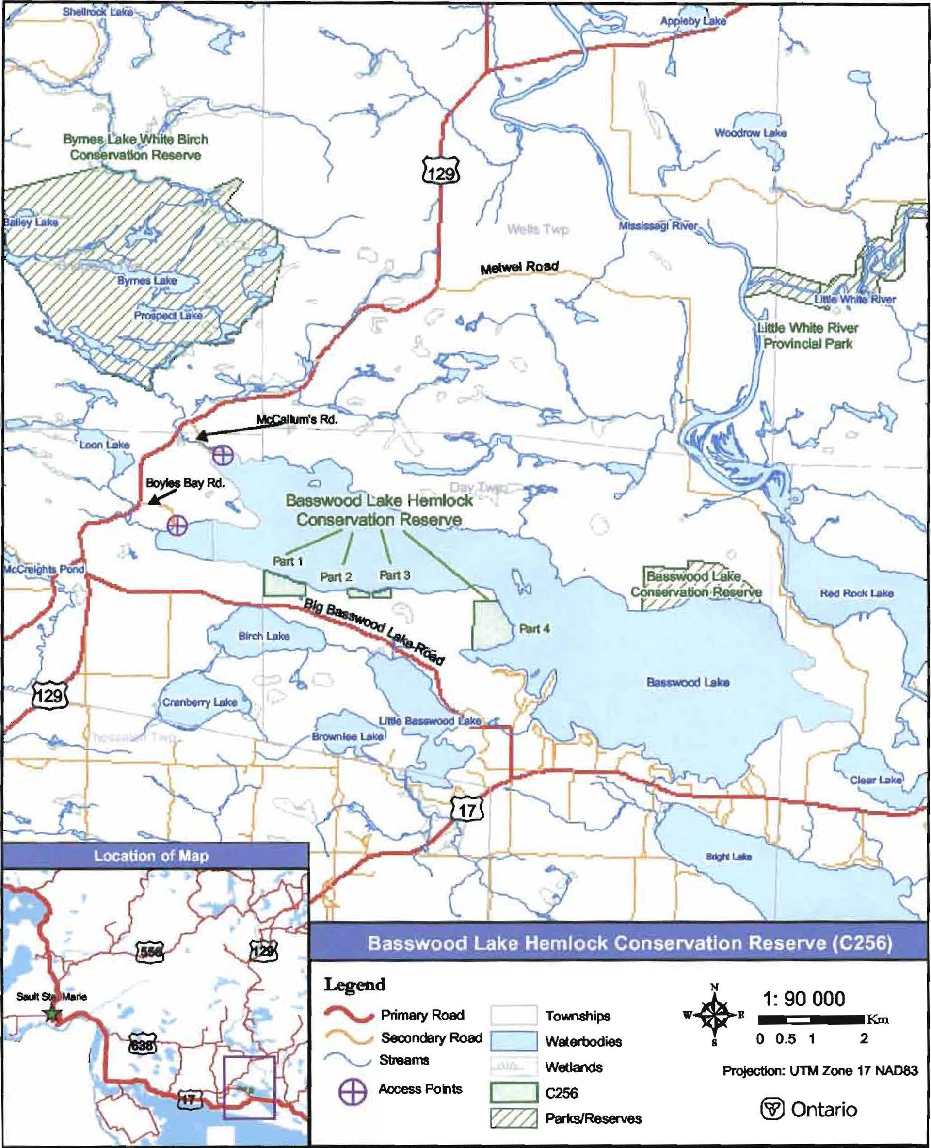
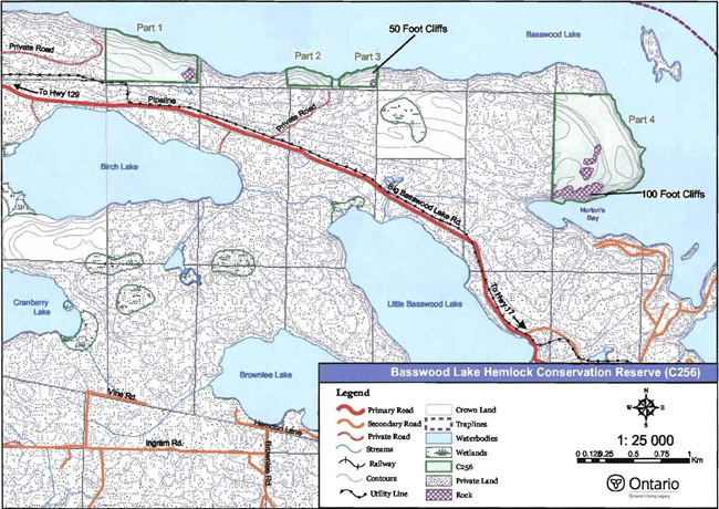
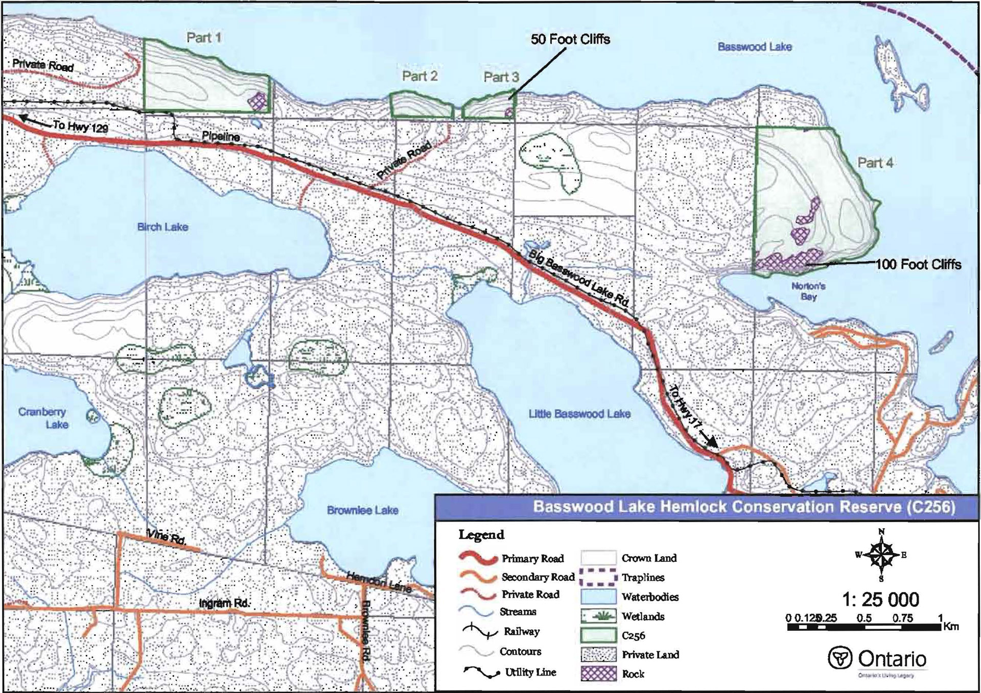
Basswood Lake Hemlock Conservation Reserve is situated approximately 15 kilometres (km) northeast of the Town of Thessalon. It is located in Day Township, within the Municipality of Huron Shores. The conservation reserve was regulated on December 7, 2002, and is approximately 104 hectares (ha) in size. The site includes four separate parcels of Crown land located along the south shore of Basswood Lake (see Appendix A, Map 1). Private lands separate each part of the conservation reserve. Part 1 of the conservation reserve is 29 ha in size and is situated 1.8 km east of Boyles Bay. Parts 2 and 3 of the site are each 5 ha in size and are approximately 800 metres (m) and 1 km east of Part 1, respectively. Part 4, the most easterly piece of the conservation reserve, is located 1.5 km from Part 3, and is 65 ha in size (see Figure 1). Table 1 summarizes the administrative details of the conservation reserve.
Whenever possible, recognizable natural and cultural features, such as creeks, shorelines, or old roads have been used to delineate conservation reserve boundaries to facilitate on–the–ground identification. The northern boundaries of Parts 1, 2, and 3 of the conservation reserve are easily identifiable as they follow the shoreline of Basswood Lake. The remaining boundaries of Parts 1, 2, and 3 are more difficult to locate as they follow the lot lines of adjacent private properties. Similarly, the eastern and southern boundaries of Part 4 are defined by the shoreline of Basswood Lake, and the northern and western boundaries follow the lot lines of adjacent private properties (see Appendix A, Map 1).
There are no public roads or trails into, or adjacent to, the conservation reserve. The road that approaches the west boundary of Part 1, and the road that runs between Parts 2 and 3, are both privately owned and cannot be used to access the conservation reserve (see Appendix A, Map 1). Access to the site is solely provided via Basswood Lake. Two public boat launches are located on the west shore of Basswood Lake and can be accessed from Highway 129 (see Appendix A, Map 1). One boat launch is located at the end of Boyle’s Bay Road and the other is located at the end of McCallum Road. The distance from the Boyle’s Bay Road access point to the most western boundary (Part 1) of the conservation reserve is approximately 1.8 km. Similarly, it is approximately 2.5 km from the McCallum Road access point to Part 1 of the site.
Basswood Lake Hemlock Conservation Reserve is located in Site District1 5E–1, which extends from Sault Ste. Marie to the Town of Spanish along the St. Marys River and Lake Huron shoreline (Hills 1959). The conservation reserve protects eastern hemlock mixedwood forest stands that are approaching old growth status. In each part of the conservation reserve, these hemlock stands extend inland, approximately 200 m, from the shoreline of Basswood Lake.
Table 1: Administrative details for Basswood Lake Hemlock Conservation Reserve.
| Name | Basswood Lake Hemlock Conservation Reserve (C256) |
|---|---|
| Site Region – Site District (Hills 1959) | 5E–1 Thessalon |
| Ecoregion – Ecodistrict (Crins and Uhlig 2000) | 5E–1 |
| OMNR Administrative Region/District/Area | Northeast Region/Sault Ste. Marie District/Northshore Area |
| UTM co–ordinates | NAD 83 17 T 313513 E 5133290 N |
| SCI Completed | February 2, 2004 |
| Regulated | December 7, 2002 |
| Area | Part 1 – 29 ha Part 2 – 5 ha Part 3 – 5 ha Part 4 – 65 ha Total – 104 ha |
| Nearest Town | Approximately 15 km northeast of the Town of Thessalon |
| Municipality | Huron Shores |
| Township(s) | Day Township |
| OBM Numbers | 2017310051300 |
| Topographical Map Number / Name | 41 J 06 Iron Bridge |
| Wildlife Management Unit | 37 |
| Forest Management Unit | Northshore Forest |
Figure 1: Map showing the location of Basswood Lake Hemlock Conservation Reserve (C256)

Enlarge Figure 1: Map showing the location of Basswood Lake Hemlock Conservation Reserve (C256)
4.2 History of the Site
Tourism plays an important role in the area surrounding Basswood Lake (historically known as Wahquekobing Lake, and later Wakwekobi Lake). Basswood Lake, Bright Lake (historically known as Mud Lake) and Hagen Lake are all known for their excellent angling and boating opportunities. These lakes are home to hundreds of private cottages and numerous commercial tourism operations.
According to Cameron (1993), the first known account of tourism in the Basswood Lake area was in the 1880s when three individuals came to Ontario to find a fugitive, who had fled from England. When the British searchers were preparing to depart for Canada, they packed a chest filled with hunting and angling gear. Their journey took them to the shores of Basswood Lake, where they located the fugitive. They remained in the Basswood Lake area for the summer, spending many happy hours fishing and hunting. When the time came for the searchers to return to England, they left the fugitive behind. Many years later the fugitive, G. F. Dryer, died peacefully in his home on the shores of Basswood Lake.
The first known tourism lodge in the area was established in 1929, when Mr. and Mrs. Lowell Stuller, of Indiana, bought a farm located on the northwest corner of Basswood Lake (Cameron 1993). There they built the "Indiana Inn" and six guest cabins. In the early 1940s, another tourism lodge was constructed on the shores of Basswood Lake. This popular tourism lodge, known as Melwel Lodge, was constructed by Weldon and Melba Moore. Melwellodge is still in operation today. In 1965, in the face of increasing development pressures, all remaining Crown lands fronting Basswood Lake were officially withdrawn from any form of disposition, to protect the lake and its fishery from over development.
According to Cameron (1993), during the late 1800s and early 1900s, the area surrounding Basswood Lake was also an important source of timber for early pioneer settlements and lumber camps. Day Township was a central point for logging operations. Timber harvested from around Basswood Lake was towed by alligators (steam powered tug boats) across the lake to Portage City, at the southeast corner of Basswood Lake. Here the logs were boomed and floated to Day Mills, a town located at the base of Bright Lake.
4.3 Inventories
Table 2 indicates the current status of natural heritage inventories that have occurred for Basswood Lake Hemlock Conservation Reserve. Recommendations for future inventory needs are located in Table 3, Section 7.2.
Table 2: Inventory and survey Information for Basswood Lake Hemlock Conservation Reserve.
| Type of Inventory | Inventory Method | Date(s) of Inventory | Report |
|---|---|---|---|
| Life Science | Aerial reconnaissance | 10 Sept. 2002 | King, L. and S. Longyear. 2003. Draft Basswood Lake Hemlock Conservation Reserve Life Science Checksheet – Step 2. Unpublished Information. Ontario Ministry of Natural Resources. |
| Earth Science | Aerial reconnaissance | 10 Sept. 2002 | Kristjansson, R. 2003. Draft Earth Science Inventory Checklist for Basswood Lake Hemlock Conservation Reserve. Unpublished Information. Ontario Ministry of Natural Resources. |
| Recreation | Ground and aerial reconnaissance | Ground: – 25 July 2002 – 15 May 2003 Air: – 10 Sept. 2002 |
Latulippe, T. and M. Hall. 2003. Recreation Inventory Report for Basswood Lake Hemlock Conservation Reserve. Unpublished Information. Ontario Ministry of Natural Resources. |
5.0 State of the Resource
5.1 Key Values
Key values are those values that make this site unique and have led to its designation as a conservation reserve. Their protection is paramount. The key values found within Basswood Lake Hemlock Conservation Reserve include the following:
- Hemlock mixedwood forest communities, which are approaching old–growth status.
Additional values as listed in Section 5.2 through Section 5.6 are also important. Descriptions in this section are not necessarily complete. If new values, key or otherwise, are identified, they will be added to this section. If any new value is considered significant, management guidelines may be modified, if required, to ensure its protection.
5.2 Earth Sciences Values
The earth science features found in Basswood Lake Hemlock Conservation Reserve are commonly encountered throughout Site District 5E–1 and are therefore considered to be of only local significance (Kristjansson 2003).
Two bedrock formations underlie the conservation reserve. Parts 1, 2, and 3 are underlain by undifferentiated sedimentary rock of the Cobalt Group, Huronian Supergroup (Kristjansson 2003). In contrast, Part 4 is underlain by Nipissing diabase (Kristjansson 2003). According to Kristjansson (2003), the surficial geology of the conservation reserve is Bedrock–Drift Complex. The topography associated with this complex is best described as ranging from steeply sloping, along the shoreline of Basswood Lake, to moderately sloping further inland. Surface deposits, where they occur on the site, are mostly till. Bare exposed bedrock is frequently encountered on the site. Additional information on the geology of the site can be found in the Basswood Lake Hemlock Conservation Reserve Earth Science inventory (Kristjansson 2003).
The most impressive earth science features of the conservation reserve are two cliffs, locally referred to as the "50–foot" and "100–foot" cliffs (see Appendix A, Map 1). The "50–foot" cliffs are located along the Basswood Lake shoreline in Part 3 of the conservation reserve and are approximately 20 m (65') in height (see Figure 2). The "100–foot" cliffs are found along the southern boundary of Part 4 of the site, and are up to 40 m (130') in height (see Figure 3). Where there are no cliffs or exposed bedrock, the Basswood Lake shoreline within the site is essentially a gravel/rubble mixture. There are no known beaches along these segments of shoreline (Latulippe and Hall 2003).
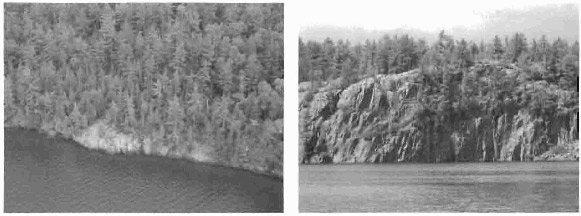
Figure 2 (left): Aerial photo "50–foot" cliffs taken during reconnaissance inventory
(T. Latulippe. 10 Sept 2002. OMNR).
Figure 3 (right): View of the "100–foot" cliffs from across Norton’s Bay
(M. Hall. 15 May 2003. OMNR).
5.3 Life Sciences Values
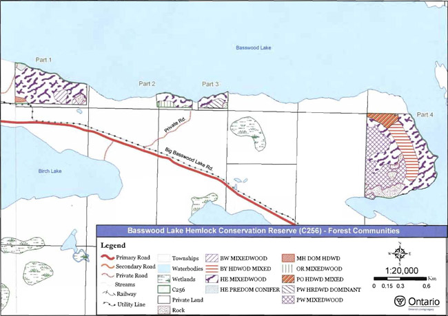
Basswood Lake Hemlock Conservation Reserve holds true to its name, as hemlock mixedwood forest stands cover the majority of the site (King and Longyear 2003). In each part of the conservation reserve, the hemlock mixedwood stands parallel the shoreline of Basswood Lake, extending inland for approximately 200 m. The regional and provincial significance of these hemlock communities has not yet been evaluated (King and Longyear 2003). However, due to the low variation in forest communities and the consistency in landform types, the diversity within the conservation reserve is considered to be low (King and Longyear 2003).
With the exception of a small white birch (Betula papyrifera Marsh.) stand, almost all of Part 1 of the conservation reserve is classified as a hemlock mixedwood2 forest (see Appendix A, Map 2; Figures 4 and 5). Parts 2 and 3 of the site are also almost entirely helmock mixedwoods, apart from a red oak (Quercus rubra L.) mixedwood stand located in the southern portion of Part 2 and a white pine (Pinus strobus L.) dominant stand in the southern portion of Part 3 (see Appendix A, Map 2). Part 4 of the conservation reserve contains white pine, yellow birch (Betula alfeghaneinsis Britt.), sugar maple (Acer saccharum Marshall) and hemlock mixedwood forest stands (see Appendix A, Map 2).
Forest stand stocking3 is evenly distributed among all four parts of the conservation reserve, at between 61 and 80 percent stocked. Two stands located in the eastern and western most parts of the conservation reserve are stocked between 81 and 99 percent (King and Longyear 2003). The age of the forest stands is a little more variable. The hemlock forest stands within the conservation reserve range in age from 127 to 132 years. These stands are approaching old growth, which for hemlock in the Great Lakes/St. Lawrence region is 140 years (King and Longyear 2003). The remainder of the stands in the site range in age from 60 to 89 years (King and Longyear 2003).
Basswood Lake Hemlock Conservation Reserve is located in a tertiary watershed of the Lake Huron Basin. While the conservation reserve is located on the shore of Basswood Lake, there are no wetlands or waterbodies within the site boundaries. Basswood Lake is an important sport fish lake for lake trout (Salvelinus namaycush), small–mouth bass (Micropterus do/omieu), whitefish (Coregonus clupeaformis), yellow perch (Perea flavescense) and walleye (Stizostedion vitreum) (Latulippe and Hall 2003).
Parts 3 and 4 of the conservation reserve are within the Iron Bridge deer yard area. Deer yard areas are extremely important, as they provide shelter, food and open areas for movement of deer in winter. Other land mammals, including black bears (Ursus americanus), are known to reside in the area surrounding Basswood Lake (Latulippe and Hall 2003).
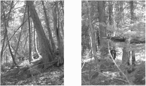
Figure 4 (on left): Hemlock mixedwood stand, located in Part 1 of the conservation reserve (E. Nixon. 15 May 2003. OMNR).
Figure 5 (on right): Broken tree in hemlock mixedwood stand, located in Part 1 of the conservation reserve (E. Nixon. 15 May 2003. OMNR).
5.4 Recreational Values
Recreational activities in Basswood Lake Hemlock Conservation Reserve are limited by the poor site access (please refer to Section 4.1 for information on access). Hunting is one recreational activity known to occur within the site. As the cliffs provide for a spectacular landscape, painting is a potential recreational activity within the conservation reserve. Other potential activities include picnicking and swimming along the few areas of flat shoreline.
Basswood Lake Hemlock Conservation Reserve is surrounded by the Basswood Lake/Bright System General Use Area (G1894). This general use area, which includes Basswood Lake, Bright Lake and Hagen Lake, is known for its excellent angling, boating and water sports. Consequently, hundreds of private cottages and numerous commercial lodges are located throughout the area. Policies for land use management are focused on preserving the existing mix of recreational uses, while also maintaining the lake trout fishery on Basswood Lake (OMNR 1983; OMNR 2003a). To view the boundaries and policies for this General Use Area, please visit the Crown Land Use Atlas at: http://www.ontarioslivinglegacy.com/crownlanduseatlas/index.html.
No fishing is permitted on Basswood Lake from October 1 to April 25 because it is classified as a fish sanctuary (OMNR 2003b).
5.5 Cultural Values
This site falls within the Robinson–Huron Treaty area. To date, no First Nation community has identified any specific Aboriginal values within the conservation reserve.
There is no known record of archeological features in the site.
5.6 Research Values
No known research and/or monitoring activities have occurred within the conservation reserve.
5.7 Site Condition
Interpretation of 1994 aerial photographs taken over Basswood Lake Hemlock Conservation Reserve show little evidence of human disturbance. This is supported by the aerial reconnaissance survey completed by the Ministry of Natural Resources in 2002, which indicated no obvious disturbance to the site (King and Longyear 2003). The conservation reserve has strong connectivity to all forest stands outside of its boundaries, with the exclusion of forest stands located south of the pipeline corridor that runs adjacent to the southern boundary of Part 1.
Although the conservation reserve is considered to be in good condition, preserving its long–term integrity could be difficult due to its small size. All but one of the forest stands in the conservation reserve extend beyond the site’s boundaries onto adjacent private properties (King and Longyear 2003). Not only does the conservation reserve have little buffering capacity to protect life science values from adjacent land use activities; it is in a relatively highly populated area, which could pose additional long–term threats to the integrity of the site.
6.0 Management Guidelines
All management guidelines in this SCI are based on direction contained in the LUS (OMNR 1999) and associated policy clarification statements. The management guidelines outlined in this section are specific to Basswood Lake Hemlock Conservation Reserve and are intended to protect the site’s unique values. The guidelines in this document may be subject to change and may be amended as necessary. If a conflict between management guidelines exists, the conservation reserve will be managed to protect the integrity of its natural values, while permitting compatible land use activities (OMNR 1997a).
Proposed new uses and/or development, as well as research and education activities, will be reviewed on a case–by–case basis. Before new proposals can be permitted, the Test of Compatibility (see Appendix B) must be passed, as well as consideration of cultural values according to Conserving a Future for our Past: Archaeology, Land Use Planning & Development in Ontario, Section 3 (MC 1997). In addition, all new proposals are subject to applicable Environmental Assessment Act (R.S.O. 1990, Chapter E.18) requirements.
The following management strategies have been devised to achieve the goal and objectives of the SCI for Basswood Lake Hemlock Conservation Reserve. A summary table of the management guidelines for this site can be found in Appendix C. For the most up–to–date version of this summary table, please refer to the Crown Land Use Atlas, located on the internet at /page/crown–land–use–policy–atlas, or contact your local Ministry of Natural Resources office. The Crown Land Use Atlas is a consolidation of existing local land use policies for Crown lands within the OLL planning area, an area that covers 45 percent of the province and that extends from Lake Simcoe in the south to the Albany River in the north.
6.1 Industrial Activities
6.1.1 Commercial Timber Harvest
The area contained within this conservation reserve (104 ha) has been withdrawn from the Northshore Sustainable Forest License area and no commercial timber harvesting will be permitted. Please refer to Section 6.4.3 for information regarding non–commercial wood harvesting.
6.1.2 Mining and Exploration
There are no mining claims or leases within this conservation reserve. Mining and surface rights have been withdrawn from staking under the Mining Act (RSO 1990 Chapter M.14). Mineral exploration is not permitted.
6.1.3 Extraction of Peat, Soil, Aggregate and Other Material
Extraction of peat, soil, aggregate and other material is not permitted.
6.1.4 Energy Generation
Hydropower development and windpower generation are not permitted.
6.2 Existing and Proposed Development
6.2.1 Transportation Corridors
6.2.1.1 Roads
According to the LUS (OMNR 1999), new roads for resource extraction will not be permitted except for those identified in Forest Management Plans prior to March 31, 1999. No new or existing roads for resource extraction were identified.
6.2.1.2 Trails
No trails have been identified within this conservation reserve. Any proposed new trails will be subject to the Test of Compatibility (see Appendix B) and applicable Ministry of Natural Resources' policies and procedures. Trail development in low–lying areas will be discouraged, as will trail development over shallow soils on rock outcrops. All new and existing trail heads and trail routes must be recorded using new technologies (ie. global positioning systems) to ensure an accurate record of the location of the feature. This location information must be provided to the Sault Ste. Marie District, Ministry of Natural Resources.
6.2.2 Other Corridor Development/Maintenance
A gas pipeline corridor runs adjacent to the south boundary of Part 1 of the conservation reserve. This corridor is not included in the regulated boundary of the site. 1\lo other communication, energy transmission, or other non–road corridors are located within this conservation reserve. New corridor developments will be actively discouraged. Proposals for new corridors will be subject to the Test of Compatibility (see Appendix B) and applicable Ministry of Natural Resources' policies and procedures.
6.2.3 Natural Heritage Appreciation Facilities/Recreational Structures
There are currently no existing authorized natural heritage appreciation facilities or recreational structures (ie. boardwalks, bird viewing platforms, kiosks, ski shelters, or interpretative signs). New natural heritage appreciation facilities and recreation structures are permitted, subject to the Test of Compatibility (see Appendix B) and applicable Ministry of Natural Resources' policies and procedures.
6.2.4 Land Disposition
Sale of Crown lands is not permitted, except for those situations described in the policy clarification tables (OMNR 2000).
No Land Use Permits (LUPs) exist within this conservation reserve for private recreation camps. New leases or LUPs may be issued for approved public uses (ie. not for private recreation camps), subject to the Test of Compatibility (see Appendix B) and applicable Ministry of Natural Resources' policies and procedures. These leases/permits will not be sold but may be eligible for enhanced tenure or transfer.
Enhanced tenure is defined as anything beyond the term and form of current tenure. All requests for transfer or enhanced tenure will be subject to the following screening criteria:
- Is the transfer or enhanced tenure consistent with the conservation reserve’s land use intent, which is the protection and enhancement of the site’s natural, recreational and cultural values?
- Is it consistent with the land disposition policies outlined in the District Land Use Guidelines, the Crown Land Use Atlas, this SCI and any other applicable document?
- Does it adversely affect the values as identified in Section 5.0, and/or conflict with other uses?
- Is land needed by the Crown to protect significant natural or recreational values outlined in this SCI?
- Does the transfer or enhanced tenure clash with traditional Aboriginal uses, land claims or agreements?
- Are all rents, taxes, fees, rates or charges paid up for the existing LUP or lease?
6.3 Commercial Activities
6.3.1 Commercial Bait Harvesting
There are no waterbodies, streams, or wetlands within this conservation reserve. However, Day Township is currently allocated to one commercial bait harvesting operation. New operations can be considered subject to the Test of Compatibility (see Appendix B) and applicable Ministry of Natural Resources' policies and procedures.
Under Public Lands Act PL 3.03.08 "Buildings for Bait Harvesting Management", cabins for the purposes of bait harvesting may be constructed on Crown land. However, such buildings should be avoided within this conservation reserve whenever possible and established on Crown land outside of the protected area.
6.3.2 Commercial Fishing
There are no waterbodies within this conservation reserve.
6.3.3 Commercial Fur Trapping
A portion of Private Land Trapping Zone BL–PL–03 occurs within the boundary of this conservation reserve. Activities associated with this private land trapping zone are permitted to continue, subject to applicable Ministry of Natural Resources' policies and procedures.
6.3.4 Bear Management Areas
No Bear Management Area (BMA) is associated with this conservation reserve. Due to the extensive private lands surrounding the conservation reserve, the establishment of a new BMA in this area will not be considered at this time.
6.3.5 Commercial Food Collection
There are currently no existing commercial food harvesting ventures. Any new ventures requiring permits from the Ministry of Natural Resources will be subject to the Test of Compatibility (see Appendix B) and applicable Ministry of Natural Resources' policies and procedures.
6.3.6 Commercial Non–Timber Forest Products
Commercial harvesting of non–timber forest products is not consistent with the intent of the conservation reserve and will not be approved.
6.3.7 Outpost Camps/Main Base Lodges
There are currently no existing authorized outpost camps or main base lodges. New outpost camps and main base lodges may be considered through planning and will be subject to the Test of Compatibility (see Appendix B) and applicable Ministry of Natural Resources' policies and procedures. The form of land tenure for these new uses will remain as a land use permit or a lease. Sale of Crown land for new outpost camps or mainbase lodges will not be permitted.
6.4 Non–Commercial Activities
6.4.1 Nature Appreciation/Recreation Activities
Off–trail hiking, cross–country skiing, snowshoeing, and other non–motorized activities will be permitted within this conservation reserve. However, should the impact of these activities degrade the landscape, the Ministry of Natural Resources will re–evaluate these permitted uses and decide upon a new strategy for this site. New trails to support these activities may be considered. Please refer to Section 6.2.1.2 for more details related to trail development.
6.4.2 Camping
There are no maintained campsites or campgrounds within this conservation reserve. Crown land camping policies apply, unless significant adverse effects on protected values necessitate further planning and management for this activity. Existing campsites should be used where they exist and campers should avoid sensitive areas.
6.4.3 Non–Commercial Consumptive Resource Use
Cutting of trees for non–commercial purposes may be authorized via permit issued by the local Ministry of Natural Resources, subject to review and determination of the impact that such cutting would have on the values identified in Section 5.0. Such permits are intended only for leaseholders, Land Use Permit holders, cottagers and other property owners within the conservation reserve who do not have road access to their property and have no alternate wood source outside of the conservation reserve. This permit is intended to cover fuelwood, dock stringers, and other occasional small scale uses.
Non–commercial harvesting of non–timber forest products such as berries, mushrooms, sphagnum moss (Sphagnum spp.), and wild rice (Zizania sp.L.) can occur provided the values of the site, identified in Section 5.0, are not jeopardized.
6.4.4 Hunting and Fishing
Hunting is a traditional activity within this conservation reserve. In conjunction with current hunting regulations and the LUS (OMNR 1999), hunting is permitted to continue.
There are no waterbodies within this conservation reserve. Recreational fishing from the shoreline of the conservation reserve is permitted in compliance with current fishing regulations.
6.4.5 ATV and Snowmobile Use
No authorized snowmobile and/or ATV trails have been identified. Please refer to Section 6.2.1.2 for more information on trails. In general, off–trail use of ATVs and snowmobiles is not permitted. However, off–trail use is permitted for licenced trappers to access their traplines and for licenced bait harvest operators to conduct bait harvest operations. Off–trail ATV and snowmobile use is also permitted for the direct retrieval of large game by hunters. In all these cases, off–trail use is only permitted provided the protection of the site’s values is not compromised. Should the impact of off–trail ATV and snowmobile use degrade the landscape, the Ministry of Natural Resources will re-evaluate these permitted uses and determine a new strategy.
6.5 Resource Management Activities
Resource management activities refer to those tools used to protect and enhance the values of this conservation reserve. Some management activities may require the use of intrusive techniques. Under normal circumstances, some of these techniques would not be permitted to occur in the conservation reserve; however, if they are found to be necessary, they may be applied under controlled conditions, to achieve a desired result. Infrastructure such as roads, trails, and buildings may need to be constructed to support activities such as prescribed burns, forest regeneration, wildfire control, and insect and disease control. Activities described in this section will be deemed acceptable if the ultimate outcome is in compliance with the management intent for this conservation reserve.
6.5.1 Insect and Disease Control
This conservation reserve will be maintained in as natural a state as possible. Insect and disease control measures should only be considered if the identified values are significantly threatened.
6.5.2 Fire Management
The Ministry of Natural Resources recognizes fire as an essential process fundamental to the ecological integrity of conservation reserves. In accordance with existing conservation reserve policy and the Forest Fire Management Strategy for Ontario, forest fire protection will be carried out as on surrounding lands.
Whenever feasible, the Ministry of Natural Resources' fire program will endeavor to use "light on the land" techniques, which do not unduly disturb the landscape, in this conservation reserve. Examples of light on the land techniques may include limiting the use of heavy equipment or limiting the number of trees felled during the fire response efforts.
Opportunities for prescribed burning to achieve ecological or resource management objectives may be considered. These management objectives will be developed with public consultation prior to any prescribed burning, and will be reflected in the document that provides fire management direction for this conservation reserve. Plans for any prescribed burning will be developed in accordance with the Ministry of Natural Resources Prescribed Burn Planning Manual (OMNR 1997b) and the Environmental Assessment Act (R.S.O. 1990, Chapter E.18).
6.5.3 Fish and Wildlife Management
New fish and wildlife management activities may be considered but will require the approval of a separate fish/wildlife management plan, which must be referenced in this SCI and/or an amendment made to this SCI to include specific management prescriptions. New fish and wildlife management activities are also subject to the Test of Compatibly (see Appendix B) and applicable Ministry of Natural Resources' policies and procedures. Fish management activities on Basswood Lake are not affected by this conservation reserve.
6.5.4 Vegetation Management
No new vegetation management activities are permitted, unless this SCI is modified to include specific management prescriptions, or a separate vegetation management plan is approved for the site and referenced in this SCI. New vegetation management activities are also subject to the Test of Compatibly (see Appendix B) and applicable Ministry of Natural Resources' policies and procedures.
6.5.5 Forest Renewal
Preference will be given to natural regeneration following any disturbance in the conservation reserve. In some cases, regeneration may be artificially assisted when it is deemed appropriate to mitigate against human disturbances (e.g. illegal occupation and trespass).
6.6 Research
Scientific research is encouraged, by qualified individuals or institutions, that contributes to a better understanding of the natural and cultural values protected by this conservation reserve or that advances the protection, planning and management of these values. The Sault Ste. Marie District Planner should be contacted for information on research and/or monitoring opportunities within this conservation reserve. Proposals to conduct research should be directed to the Northshore Area Supervisor, Ministry of Natural Resources, Blind River Area Office, and will be subject to the Test of Compatibility (see Appendix B) and applicable Ministry of Natural Resources' policies and procedures. Any site that is disturbed during research activities is to be rehabilitated as closely as possible to its original condition. Collecting may only be permitted as part of an authorized research project, and may be subject to appropriate permits and conditions.
Existing Forest Resource Inventory surveys and approved resource monitoring activities are permitted to continue.
6.7 Marketing
No active marketing of this conservation reserve is anticipated.
6.8 First Nations
Traditional activities and Aboriginal rights, as defined in the Robinson–Huron Treaty and other applicable legislation, will not be affected within or by the boundaries of this conservation reserve.
Any First Nation land claims within this area will be addressed according to appropriate Ministry of Natural Resources procedures. When possible, the Ministry of Natural Resources will work with the Ontario Ministry of Culture to identify archaeological sites to be protected.
7.0 Recommendations
7.1 Additions to the Reserve
The small size of the site, private ownership of adjacent properties, and lack of easily identifiable boundaries may create a challenge in preserving the long–term integrity of the site. The addition of a parcel of Crown land, situated directly southeast of Part 3 of the conservation reserve, should be considered (see Appendix A, Map 1). This is one of the few remaining parcels of Crown land in the area surrounding Basswood Lake. The addition of this parcel of Crown land would protect a wetland area, as well as an additional section of a white pine stand, part of which is located in Part 3 of the conservation reserve.
7.2 Future Needs and Considerations
Table 3 highlights future needs and considerations for Basswood Lake Hemlock Conservation Reserve.
Table 3: Future needs and considerations for Basswood Lake Hemlock Conservation Reserve.
| Future Needs/Considerations | Details |
|---|---|
| Complete Life Science Inventory | The Northeast Region should complete the final stage (fifth step) of the life science inventory. Completion of the final stage includes an assessment of the site’s significance and its contribution to the parks and protected areas program. |
| Adjacent Property Owner Involvement/Education | Efforts should be made to educate adjacent private property landowners about the potential impacts of their activities on the conservation reserve. Specific consideration should be given to landowners whose properties are adjacent to and form a corridor between carts of the conservation reserve. |
| Boundary Marking | The vectored boundaries of the conservation reserve should be marked to protect the site from adjacent land use activities |
| Winter Recreational Inventory | An attempt should be made to assess the level of winter use within the conservation reserve, including the presence or absence of snowmobiling, skiing, and snowshoeing. |
| Partnership Development | Efforts should be made to work with partners (such as the Ontario Forest Research Institute (OFRI), Sault College of Applied Arts and Technology) to gather baseline data on this site to assist with future monitoring and inspection activities. |
| Funding | Efforts should be made to obtain funding to support the above listed items, including monitoring, assessment, and inspection requirements for this site. |
7.3 Monitoring
Periodic monitoring of human activities and/or their impacts within this conservation reserve will be conducted. A schedule for cursory field monitoring will be identified within the District’s annual compliance plan and an IFM (Integrated Field Monitoring) inspection report will be filed at the Blind River Area Office. The Northshore Area Supervisor will oversee these activities. In addition, Conservation Officers will complete periodic compliance monitoring to ensure the projection mandate is maintained. If at any time human activities are deemed to be negatively impacting the protected features, the activities will be reviewed and measures taken to mitigate any disturbance.
Approved inventory, monitoring, assessment, or research activities that are compatible with protection objectives are encouraged. Any area that is disturbed during research activities is to be rehabilitated as closely as possible to its original condition. The Northshore Area Supervisor may apply additional conditions.
8.0 Implementation, Review and Revisions
8.1 Responsibility
The Blind River Area Office will be responsible for implementing the management policies and guidelines for Basswood Lake Hemlock Conservation Reserve. Their primary role will be to provide public information and compliance monitoring to ensure adherence to current policies and guidelines.
8.2 Review and Revisions
The Basswood Lake Hemlock Conservation Reserve SCI will be reviewed every five years by the District Planner to confirm and update the information in this document. Revisions to this document will be subject to requirements as specified in the Environmental Assessment Act (R.S.O. 1990, Chapter E.18). If changes in management direction are needed at any time, the significance of the changes will be evaluated. Minor amendments to the plan that do not alter the overall protection objectives may be considered and approved by the Northshore Area Supervisor without further public consultation. All minor amendments to the SCI will be documented in Appendix E. In assessing major amendments, the need for a more detailed Resource Management Plan (RMP) will first be considered. Where a RMP is not considered necessary or feasible, a major amendment to management direction may be considered with public consultation. Major amendments will be recommended by the District Manager and approved by the Regional Director, and will follow the appropriate guidelines (OMNR 2001b).
Literature Cited
Cameron, E.M. 1993. Pioneers in a Land of Promise. Rae’s North Country Printing Service: Iron Bridge, Ontario.
Crins, W.J. and P.W.C. Uhlig. 2000. Ecoregions of Ontario: Modification to Angus Hills' Site Regions and Site Districts – Revisions and Rationale.
Hills, G.A. 1959. A Ready Reference for the Description of the Land of Ontario and its Productivity. Preliminary Report. Ontario Department of Lands and Forests. Ontario.
Kristjansson, R. 2003. Draft Earth Science Inventory Checklist for Basswood Lake Hemlock Conservation Reserve. Unpublished Information. Peterborough Main Office. Ontario Ministry of Natural Resources.
Latulippe, T. and M. Hall. 2003. Recreation Inventory for Basswood Lake Hemlock Conservation Reserve. Unpublished information. Sault Ste. Marie District Office. Ontario Ministry of Natural Resources.
King, L. and S. Longyear. Basswood Lake Hemlock Conservation Reserve Life Science Checksheet– Step 2. Unpublished Information. Northeast Regional Planning Unit. Ontario Ministry of Natural Resources.
Ministry of Culture (MC). 1997. Conserving a Future for Our Past: Archeology Land Use Planning and Development in Ontario, Section 3.
Ontario Ministry of Natural Resources. 1983. Blind River District Land Use Guidelines. Queen’s Printer for Ontario: Ontario, Canada.
Ontario Ministry of Natural Resource. 1997a. Conservation Reserves. Lands and Waters Branch Policy. Public Lands Act, PL 3.03.05. Date Issued: February 11, 1997.
Ontario Ministry of Natural Resources. 1997b. Prescribed Burn Planning Manual. AFFMB Publication No. 313. Ontario Ministry of Natural Resources.
Ontario Ministry of Natural Resources. 1999. Ontario’s Living Legacy Land Use Strategy. Queen’s Printer for Ontario: Ontario, Canada.
Ontario Ministry of Natural Resources. 2000. Conservation Reserve Policy as Amended by the Ontario’s Living Legacy Land Use Strategy. Unpublished Information.
Ontario Ministry Natural Resources. 2001a. Forest Information Manual. Queen’s Printer for Ontario: Toronto, Ontario.
Ontario Ministry Natural Resources. 2001b. Procedures for the Amendment of Ministry of Natural Resources Land Use Direction. Ontario Ministry of Natural Resources.
Ontario Ministry Natural Resources. 2002. Buildings for Bait Harvesting Management. Public Lands Act, PL 3.03.08.
Ontario Ministry of Natural Resources. 2003a. Crown Land Use Atlas. Accessed: November 27, 2003] http://www.ontarioslivinglegacy.com/crownlanduseatlas/index.html.
Ontario Ministry of Natural Resources. 2003b. Recreation Fishing Regulations Summary. Queen’s Printer for Ontario: Ontario, Canada.
R.S.O. 1990, Chapter E.18. Environmental Assessment Act. [Accessed: September 15, 2003] http://www.e–laws.gov.on.ca/DBLaws/Statutes/English/90e18_e.htm.
R.S.O. 1990, Chapter M.14. Mining Act. [Accessed: September 15, 2003] http://www.e-laws.gov.on.ca/DBLaws/Statutes/English/90m14_e.htm.
Thompson, J. 2001. Northeast Region Guidelines on the Planning Process for Conservation Reserves: Statements of Conservation Interest and Resource Management Plan. Unpublished information. Ontario Ministry of Natural Resources.
Appendix A: Basswood Lake Hemlock Conservation Reserve Maps
Map 1: Recreational Values Map for Basswood Lake Hemlock
Enlarge Map 1: Recreational Values Map for Basswood Lake Hemlock
Map 2: Forest Composition Map of Basswood Lake Hemlock
Enlarge Map 2: Forest Composition Map of Basswood Lake Hemlock
Appendix B: Test of Compatibility
Test of Compatibility
The Conservation Reserve policy provides broad direction with regard to the permitted uses. The policy provides only an indication of the variety of uses that will be considered acceptable in conservation reserves. Any new uses, and commercial activities associated with them, will be considered on a case by case basis, and, subject to the following test of compatibility. To ensure a standard screening process is followed, reviews of all current and new activities will be subject to the screening criteria as specified by the Environmental Assessment Act (R.S.O. 1900, Chapter E.18).
The following outlines the two steps involved in performing a Test of Compatibility. An assessment of current activities would only follow step two, which focuses on the impacts. An assessment of any new activity would consider the impact of the activity and its conformity to the SCI/RMP.
1. Conformity to SCI/RMP:
SCI describe values for which an area has been set aside and the range of appropriate uses that will be permitted in the area. SCI may also speak to the acceptability of other 'new' uses currently not occurring in the area.
The first 'test' is: "do proposed new land uses and/or commercial activities conform to the direction of the SCI/RMP for the conservation reserve? Would the new use(s) depart from the spirit of appropriate indicator land uses in the SCI/RMP?"
2. Impact Assessment:
If the proposed use(s) pass test it is important to determine their impact on the area before they are approved. This should include the following:
- Impact on natural heritage values: "will the new use(s) impact any natural values in the area? If so how and to what degree? Is it tolerable?"
- Impact on cultural values: "will the new use(s) impact an historical or archaeological values in the area?"
- Impact on research activities: "will the new use(s) affect research activities in the area?"
- Impact on current uses: "will the new use(s) have any negative impact on the array of current uses?"
- Impact on area administration: "will the new use(s) increase administrative costs and/or complexity?" (For example, the cost of area monitoring, security and enforcement).
- Impact on accommodating the use outside the conservation reserve: "Could the use(s) be accommodated as well or better outside the conservation reserve?"
- Impact on socio–economics of the area: "will the new use(s) affect the community(ies) surrounding the area in a positive or negative way?" (For example, will the new use make an area less remote thereby affecting a local tourism industry that is dependent on the area’s remoteness for its appeal?"
- Impact on area accessibility: "does the new use(s) give someone exclusive rights to the area or a portion of the area to the exclusion of other existing uses?"
Appendix C: Summary of Permitted Uses
For the most recent version of this policy report, please refer to the Crown Land Use Atlas located on the internet at /page/crown–land–use–policy–atlas, or contact your local Ministry of Natural Resources office.
***For the most recent version of this policy report, please refer to the Crown Land Use Atlas located on the internet at /page/crown–land–use–policy–atlas, or contact your local Ministry of Natural Resources office.***
Crown Land Use Atlas–Policy Report
Policy Report Edit Request Form
Identification:
ID: C256
Area Name: Basswood Lake Hemlock
Area (ha): 104
Designation: Conservation Reserve (Ontario’s Living Legacy)
District(s): Sault Ste. Marie
Description:
This conservation reserve provides representation of old growth hemlock and sugar maple dominated stands along the south shore of Basswood Lake in Site District 5E–1.
Basswood Lake Hemlock was regulated as a conservation reserve on December 7, 2002.
Land Use Intent:
Management of this area is also governed by the general policies contained in the Land Use Strategy ( 1999).
Management Direction:
Those uses and management activities not listed in the following table are governed by existing conservation reserve policy. Over time the management direction will be elaborated in a Statement of Conservation Interest or Resource Management Plan. Any new uses, and commercial activities associated with conservation reserves, will be considered on a case by case basis, and they must pass a test of compatibility to be acceptable. Compatibility is normally determined through a planning process.
Commercial Activities
| Activity | Permitted | Guidelines |
|---|---|---|
| Aggregate Extraction | No | |
|
Baitfishing Existing: |
Yes |
Existing use permitted to continue, unless there are significant demonstrated conflicts. |
| Baitfishing New: | Maybe | New operations can be considered, subject to the "test of compatibility". |
| Commercial Fishing Existing: | Yes | Existing use permitted to continue, unless there are significant demonstrated conflicts. |
| Commercial Fishing New: | Maybe | New operations can be considered, subject to the "test of compatibility". |
| Commercial Fur Harvesting Existing: | Yes | Existing use permitted to continue, unless there are significant demonstrated conflicts. Existing trap cabins can continue; new cabins are not permitted. |
| Commercial Fur Harvesting New: | Maybe | New operations can be considered, subject to the "test of compatibility" |
| Commercial Hydro Development | No | |
| Commercial Timber Harvest | No | |
| Commercial Tourism Existing: | Yes | Existing authorized facilities can continue, unless there are significant demonstrated conflicts. |
| Commercial Tourism New: | Maybe | New tourism facilities can be considered during the planning for an individual reserve. |
| Bear Hunting by Nonresidents (guided) Existing: | Yes | Existing authorized operations permitted to continue. |
| Bear Hunting by Nonresidents (guided) New: | No | New operations not permitted. |
| Outfitting Services Existing: | Yes | Existing authorized operations permitted to continue. |
| Outfitting Services New: | Maybe | New operations can be considered during the planning for an individual reserve. |
| Outpost Camps Existing: | Yes | Existing authorized operations permitted to continue. |
| Outpost Camps New: | Maybe | New operations can be considered during the planning for an individual reserve |
| Resorts/Lodges Existing: | Yes | Existing authorized operations permitted to continue. |
| Resorts/Lodges New: | Maybe | New operations can be considered during the planning for an individual reserve |
| Boat Caches (Managed) Energy Transmission and Communications Corridors Existing: | Yes | These facilities should avoid conservation reserve lands wherever possible. |
| Boat Caches (Managed) Energy Transmission and Communications Corridors New: | No | These facilities should avoid conservation reserve lands wherever possible. |
| Food Harvesting (Commercial) Existing: | Maybe | |
| Food Harvesting (Commercial) New: | Maybe | |
| Mineral Exploration and Development | No | |
| Peat Extraction | No | |
| Wild Rice Harvesting Existing: | Yes | |
| Wild Rice Harvesting New: | Maybe |
Land and Resource Management Activities
| Activity | Permitted | Guidelines |
|---|---|---|
| Crown Land Disposition Private Use: | Maybe | Sale of lands is not permitted, except for minor dispositions in support of existing uses (e.g., reconstruction of a septic system). Renewals of existing leases and land use permits are permitted. Requests for transfer of tenure will be considered in the context of the Statement of Conservation Interest or Resource Management Plan. |
| Crown Land Disposition Commercial Use: | Maybe | New leases or land use permits permitted for approved activities. Tourism facilities can apply to upgrade tenure from LUP to lease. |
| Fire Suppression | Yes | Fire suppression policies are similar to adjacent Crown lands, unless alternative fire policies have been developed through a planning process. |
| Fish Habitat Management | Maybe | |
| Fish Stocking | Maybe | Conservation Reserves policy indicates that "featured species management" may be permitted. |
| Insect/Disease Suppression | Maybe | |
| Inventory/Monitoring | Yes | |
| Prescribed Burning | Maybe | |
| Road (Resource Access) Existing: | Yes | Existing roads can continue to be used. Continued use will include maintenance and may include future upgrading. |
| Road (Resource Access) New: | Maybe | New roads for resource extraction will not be permitted, with the exception of necessary access to existing forest reserves for mineral exploration and development. |
| Vegetation Management | Maybe | Conservation Reserves policy indicates that Featured Species Management and Natural Systems Management may be permitted. Vegetation management can be considered in a planning process. |
| Wildlife Population Management | Maybe |
Science, Education and Heritage Appreciation
| Activity | Permitted | Guidelines |
|---|---|---|
| Collecting | No | |
| Historical Appreciation | Yes | |
| Nature Appreciation | Yes | |
| Photography and Painting | Yes | |
| Research | Yes | |
| Wildlife Viewing | Yes |
Recreation Activities and Facilities
| Activity | Permitted | Guidelines |
|---|---|---|
| All Terrain Vehicle Use On Trails: | Yes | Existing use permitted to continue where it does not adversely affect the values being protected. |
| All Terrain Vehicle Use Off Trails: | No | ATV use off trails is not permitted except for direct retrieval of game. |
| Campgrounds | Maybe | |
| Food Gathering | Yes | |
| Horseback Riding (trail) | Yes | Existing use on trails permitted. |
| Hunting | Yes | |
| Mountain Bike Use | Yes | Existing use on trails permitted. |
| Motor Boat Use Commercial: | Yes | |
| Motor Boat Use Private: | Yes | |
| Non–motorized Recreation Travel | Yes | |
| Private Recreation Camps (Hunt Camps) Existing: | Yes | Existing camps permitted to continue, and may be eligible for enhanced tenure, but not purchase of land. |
| Private Recreation Camps (Hunt Camps) New: | No | |
| Rock Climbing | Maybe | |
| Snowmobiling On Trails: | Yes | Existing use permitted to continue where it does not adversely affect the values being protected. |
| Snowmobiling Off Trails: | Maybe | Snowmobile use off trails is not permitted, except that snowmobiles may be used for direct retrieval of game. |
| Sport Fishing | Yes | |
| Trail Development Existing: | Yes | |
| Trail Development New: | Maybe | |
Note: The policies outlined in this table do not supersede any Aboriginal or treaty rights that may exist, or other legal obligations.
Management of this conservation reserve is carried out within the context of Conservation Reserve policy as amended by the policies for new conservation reserves outlined in the Ontario’s Living Legacy Land Use Strategy.
Source of Direction:
Ontario’s Living Legacy Land Use Strategy (1999)
Conservation Reserves Policy (1997)
Blind River District Land Use Guidelines (1983)
Appendix D: Regulation Public Consultation Materials
September 1, 2000
To: Ontario Living Legacy Stakeholders
Dear Sir/Madam:
On July 16, 1999, the Ontario Government released the Ontario’s Living Legacy Land Use Strategy, a broad land use approach to the planning and management of much of the Crown lands in central and parts of northern Ontario. A major part of the Ontario’s Living Legacy Land Use Strategy was a government commitment to the biggest expansion of provincial parks and conservation reserves in Ontario’s history. Ontario intends to add 378 new areas to its protected areas system. Ontario’s Living Legacy is a momentous achievement that will be recognized around the world as a significant contribution to sustaining our natural environment. A copy of the Land Use Strategy is available from our office upon request.
In accordance with the recommendations in the Land Use Strategy, the Ministry of Natural Resources is now implementing the process of establishing these 378 new protected areas. The first step in this process is for the Ministry to consult on the boundaries of these areas. In November 1999, MNR held boundary consultations on 64 sites across the OLL Planning Area. Eight of these sites were within Sault Ste. Marie District. At this time, Sault Ste. Marie District has prepared 19 more sites for boundary refinement consultation. Adjacent Districts are consulting an additional two sites, which are also partially contained within Sault Ste. Marie District, on. In future years, the remaining recommended protected areas from the Land Use Strategy will be put forward for similar consultations.
As stated in the Land Use Strategy, the boundary refinement process will consider local ecological information and will attempt to establish regulated boundaries along features that can be identified on the ground. The boundary refinement process may result in modest increases or decreases in the sizes of the protected areas. Any existing commitments for the areas, which were considered during the land use planning process, will be considered in defining the final boundary.
Following is a list of the 21sites in SSM District scheduled for boundary consultation this year. These sites include both provincial parks and conservation reserves. The Land Use Strategy established the Ministry’s intent to add these Crown lands to Ontario’s protected areas system, following the extensive public consultation associated with Ontario’s Living Legacy and the Lands for Life land use planning initiatives between 1997 and 1999. The Ministry is inviting public comment on the proposed boundaries of these protected areas prior to their finalization and ultimate regulation under the Provincial Parks Act or the Public Lands Act.
- C227 – Glen Crombie Conservation Reserve
- P238 – Mississagi River Provincial Park Additions
- C243 – Wagong Lake Forest Conservation Reserve
- C244 – Rawhide Lake Conservation Reserve
- C246 – Echo River Hardwoods Conservation Reserve
- C247– Byrnes Lake White Birch Conservation Reserve
- P253 – Goulais River Provincial Park
- C256 – Basswood Lake Hemlock Conservation Reserve
- C258 – Thessalon River Delta / Rock Lake Red Oak Conservation Reserve
- C260 – Rose Lake Dune Peatland Complex Conservation Reserve
- C262 – Stuart Lake Wetland Conservation Reserve
- P273 – Algoma Headwaters Provincial Park
- P274 – Wenebegon River Provincial Park
- P277 – Aubinadong – Nushatogaini Rivers Provincial Park
- P278 – Pancake Bay Provincial Park Additions
- P282 – Batchawana River Provincial Park
- P285 – Sandy Islands Provincial Nature Reserve
- C289 – Searchmont South Forest Conservation Reserve
- C291 – Goulais River Beach Ridges Conservation Reserve
- P292 – Lake Superior Provincial Park Additions
- C307 – lie Parisienne Conservation Reserve
Your name and address have been included within a Ministry mailing list of persons potentially interested in these boundary consultations. The mailing list includes a range of individuals and groups, such as nearby landowners, resource users, persons with other rights or tenure (e.g. land use permit, Mining Act rights), municipalities, and others who may have an interest in the area. Accompanying this letter, you will find background information (factsheets, maps) for the site(s) we have determined to be of interest to you. More detailed maps and information about the proposed boundaries for all 21 sites are available from this office, or from the Blind River Area Office, 62 Queen Ave., Blind River.
In the future and subject to the intended regulation of these areas as provincial parks and conservation reserves, Ontario Parks and the Ministry of Natural Resources will undertake a management planning process to determine the long–term management of these protected areas. Depending upon the complexity of issues related to the provincial parks, management planning may take the form of a simple Interim Management Statement or a more detailed Park Management Plan. In the case of planning for conservation reserves, a simple Statement of Conservation Interest or a more detailed Resource Management Plan will result. Please let us know if you would like to be notified when planning begins.
Planning, management and permitted uses within these provincial parks and conservation reserves would be consistent with the commitments of the Ontario’s Living Legacy Land Use Strategy.
The Ministry is collecting comments and information regarding these proposed provincial park and conservation reserve boundary reviews under the authority of the Provincial Parks Act and the Public Lands Act respectively. These comments will assist the Ministry in making decisions and determining further public consultation needs. Comments and opinions will be kept on file and may be included in study documentation that is made available for public review. Under the Freedom of Information and Protection of Privacy Act (1987), personal information will remain confidential unless prior consent is obtained. However, the Ministry may use this information as public input on other resource management surveys or projects. For further information regarding this Act, please contact Paul Glassford, A/Information Management Supervisor, Ministry of Natural Resources, Sault Ste. Marie District (705-949-1231).
If you would like to discuss the proposed boundaries and the protection of these areas under the Provincial Parks Act and/or the Public Lands Act, please contact Erin Nixon, District Planner, Ministry of Natural Resources, 64 Church Street, Sault Ste. Marie, Ontario, P6A 3H3; telephone 705- 949-1231 ext. 247, fax 705- 949-6450, by October 6, 2000. Further information on Ontario’s Living Legacy is available in our office or by visiting the Ministry’s internet website at www.mnr.gov.on.ca/MNR/oll/
Thank you for your interest.
Yours sincerely,
Dick Hagman
A/District Manager
Sault Ste. Marie District
DH/sw Attachments:
Provincial Park and/or Conservation Reserve Factsheet(s)
Proposed Site Boundary Map(s)
Key Map
Permitted Uses Table(s) for Provincial Parks and/or Conservation Reserves
On peut obtenir Ia version francaise de Ia presente lettre en s'adressant au bureau du MRN le plus proche, a l'adresse ou au numero de telephone ci–dessous.
Basswood Lake Hemlock Hemlock Conservation Reserve (C256) Fact Sheet
September, 2000
Background
On July 16, 1999, the Ontario Government released the Ontario’s Living Legacy Land Use Strategy to guide the planning and management of Crown lands in central and parts of northern Ontario. A major part of the Ontario’s Living Legacy Land Use Strategy was a government intent to establish 378 new protected areas. This commitment marks the biggest expansion of provincial parks and conservation reserves in Ontario’s history.
The proposed Basswood Lake Hemlock Conservation Reserve is part of this significant expansion of Ontario’s protected areas system.
Size and Location
The Basswood Lake Hemlock Conservation Reserve is located approximately 13 km northeast of Thessalon in Day Township. The site consists of several parcels of Crown land forming a narrow linear band along the southern shore of the western arm of Basswood Lake. The total area of this conservation reserve is approximately 109 ha.
Area Highlights
The Basswood Lake Hemlock Conservation Reserve is located within ecological site district SE–1, a 25 km deep band extending from Sault Ste. Marie to Spanish along the St. Mary’s River and Lake Huron shoreline. This site district is characterized along the coast by lacustrine plains interrupted by small bedrock knolls, and inland by bedrock controlled, till–covered uplands. Natural vegetation communities that develop within this area combine species from both the Great Lakes / St. Lawrence and Boreal forest regions.
This conservation reserve, which has been recommended as being a Provincially Siginificant site, provides representation of old–growth hemlock forests on moderately broken, shallow sandy till uplands. Hemlock stands, concentrated along the lake shoreline of this site, are more than 200 years old. The eastern portion of the conservation reserve consists of mature (160–year–old) sugar maple dominated stands while red oak, yellow birch, white pine, and eastern white cedar occur in various mixtures throughout. This relatively undisturbed shoreline environment provides an important wildlife corridor and shelter area, particularly for the area’s wintering deer populations.
Basswood Lake is recognized as an important recreational area. The lake, including the area of the conservation reserve, is surrounded by private land.
Land Use Intent
Conservation reserves are areas of Crown land set aside by regulation under the Public Lands Act.
Conservation reserves complement provincial parks in protecting representative natural areas and special landscapes. Most recreational (e.g. hiking, skiing, tourism related uses, nature appreciation) and non–industrial (e.g. fur harvesting, commercial fishing and bait harvesting) activities that have traditionally been enjoyed in the area will continue, provided that these uses do not impact on the natural features needing protection. Hunting and fishing are also permitted within all new conservation reserves recommended through Ontario’s Living Legacy.
Commercial timber harvesting, mining, aggregate extraction and commercial hydroelectric development are prohibited in conservation reserves. Careful mineral exploration may occur in specific new conservation reserves proposed through Ontario’s Living Legacy, in areas that have provincially significant mineral potential. If a portion of a new conservation reserve is to be developed for a mine, it would be removed from the reserve, and appropriate replacement lands would be placed in regulation. Please refer to Table 4 from the Land Use Strategy for a detailed summary of permitted uses in conservation reserves.
Next Steps
The Land Use Strategy established the Ministry’s intent to add these Crown lands to Ontario’s protected areas system, following the extensive public consultation associated with the Ontario’s Living Legacy and Lands for Life land use planning initiatives between 1997 and 1999. Prior to the finalization of the boundary of this conservation reserve proposed for regulation under the Public Lands Act, the Ministry is inviting public comment on the proposed boundary from all potentially affected stakeholders and First Nations from September 6 to October 6, 2000.
In the interim, the area has been withdrawn and protected from resource extraction activities such as timber harvesting, hydroelectric development, aggregate extraction and new mineral exploration.
In the future and subject to the intended regulation of the area as a conservation reserve, the Ministry of Natural Resources will prepare a long term management plan for this area. Depending upon the complexity of issues within this conservation reserve, management planning may take the form of a simple Statement of Conservation Interest or a more detailed Resource Management Plan. Please let us know if you would like to be notified when planning begins.
Planning, management and the uses permitted within this conservation reserve will be consistent with the commitments of the Ontario’s Living Legacy Land Use Strategy.
For More Information
For further information on the proposed Basswood Lake Hemlock Conservation Reserve, please contact Erin Nixon, District Planner, Ministry of Natural Resources, Sault Ste. Marie District (705-949-1231 ext. 247). You may also visit the Ministry’s Internet website at /ministry–natural–resources–and–forestry for information about Ontario’s Living Legacy.
Appendix E: Amendments to the SCI
1 Site districts are areas characterized by physiographic similarities, and by the successional trends exhibited by the predominant vegetation types on those physiographic regions (Hills 1959; Crins and Uhlig 2000).
2 A hemlock mixedwood stand contains less than 30 percent hardwood species in the main forest canopy and hemlock js the dominant conifer component (King and Longyear 2003) the conservation reserve contains white pine, yellow birch (Betula alleghaneinsis Britt.), sugar maple (Acer saccharum Marshall) and hemlock mixedwood forest stands (see Appendix A, Map 2).
3 Stocking is a qualitative measure of the density of tree cover in a forest stand. Stocking represents the density of forest stems based on average age, height, canopy closure, and species composition in a forest.