Bear Creek Conservation Reserve Management Statement
This document provides policy direction for the protection, development and management of the Bear Creek Conservation Reserve and its resources.
Statement of Conservation Interest
Ministry of Natural Resources
Parry Sound District
Prepared with the assistance of:
Meteek & Company
Huntsville, Ontario
March 2005
Approval Statement
We are pleased to approve this Statement of Conservation Interest for Bear Creek Conservation Reserve (C84).
This 212 hectare conservation reserve is in Hills’ ecological Site District 5E-8. The area has typical transitional zone characteristics between the uplands of Algonquin Highlands and the Georgian Bay coastal wave washed rock barrens. It is represented by a landform of gently sloping plain of bedrock ridges with fairly broad pockets of silty clay and sand. Bear Creek consist of organic-rich valley bottom interspersed with treed wetlands and graminoid marshes bordered by uplands knolls to the north and south. Morgan’s Lake and Thirty Lake and their meandering southerly outflow tributaries mark the eastern, western and southern edges of the conservation reserve. Although a complete vegetation inventory has not been done, the conservation reserve supports a multitude of vascular plants species, as well as a range of birds, mammals, reptiles, amphibians and insects.
Bear Creek Conservation Reserve is one of 378 new protected areas approved through Ontario’s Living Legacy Land Use Strategy, aimed, in part, at completing Ontario’s system of parks and protected areas. This conservation reserve is situated approximately 5 kilometres south of the proposed Bridge Lake Outwash Plain Forest Conservation Reserve (C82).
During the prepa ration of Ontario’s Living Legacy, the public was widely consulted and provided valuable input into what became Ontario’s Living Legacy Land Use Strategy. Comments received during that time and during consultation related to the formal Public Lands Act regulation of this conservation reserve were generally supportive of the protection of this area. Stakeholders who provided comment during the earlier consultation for this site were subsequently consulted regarding the draft Statement of Conservation Interest and any comments were considered in the finalization of this document.
This document replaces the Statement of Conservation Interest that was approved in March 2001, to reflect one change in provincial direction (regarding mineral exploration) and to also improve the clarity as to MNR’s intent for this site. This Statement of Conservation Interest will provide guidance for the management of the conservation reserve and provide the basis for the ongoing monitoring of activities. More detailed direction is not anticipated at this time. Should significant facility development or other uses be considered or complex issues arise which require additional studies, more defined management direction, or special protection measures, then a detailed Resource Management Plan will be prepared with full public consultation.
Bear Creek Conservation Reserve is managed under the direction of the District Manager and the Bracebridge Area Supervisor of the Ministry of Natural Resources, Parry Sound District.
Approved by:
R. Griffiths
District Manager
Parry Sound District
Approved by:
Ron Running
Regional Director
Southern Region
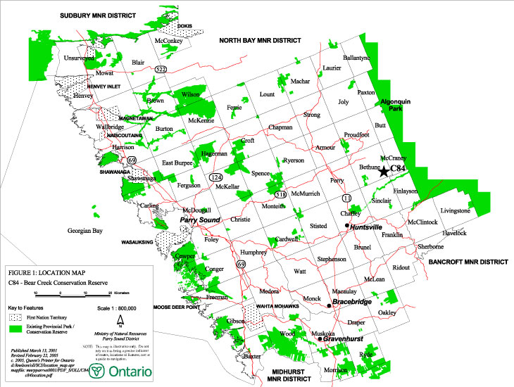
Figure 1: Location Map of Bear Creek Conservation Reserve
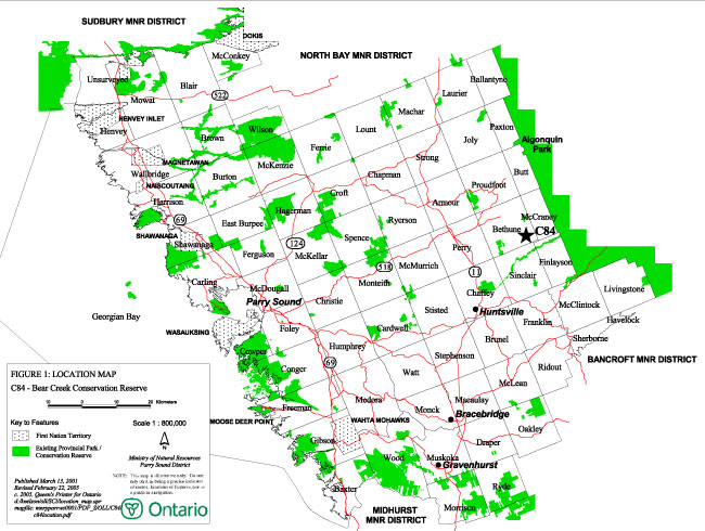
Enlarge Figure 1: Location Map of Bear Creek Conservation Reserve
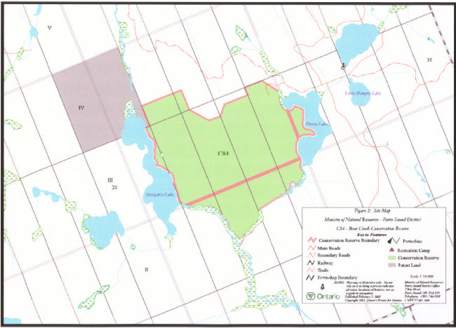
Figure 2: Site Map of Bear Creek Conservation Reserve
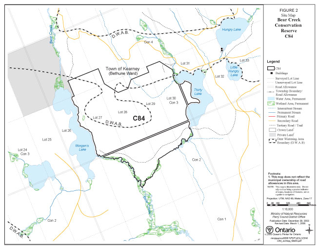
Enlarge Figure 2: Site Map of Bear Creek Conservation Reserve
1.0 Introduction
Ontario’s Living Legacy, the result of an extensive planning process that began in early 1997, culminated in the approval in July 1999 of a Land Use Strategy that identifies the intended strategic direction for Crown land in central and northern Ontario, including the completion of Ontario’s system of parks and protected areas. This process, which included public consultation, resulted in the recommendation for regulation of 378 new protected areas, including Bear Creek Conservation Reserve (C84).
Bear Creek Conservation Reserve is located in southern Bethune Ward of the Municipality of the Town of Kearney, in the Territorial District of Parry Sound. The conservation reserve is bounded by Morgan’s Lake to the west and Thirty Lake to the east. Bear Creek flows south from Morgan’s Lake and forms part of the southern boundary of the conservation reserve. The site consist of 212 hectares of Crown land (Figures 1 and 2).
Bear Creek Conservation Reserve contains representative portions of 2 landforms and several vegetation types. The site is dominated by landform IIIb-1 (weakly broken outwash plain), with a smaller portion dominated by landform Ia-37 (moderately broken shallow sandy till uplands (bare bedrock)). This contributes towards completing the system of protected areas within Site District 5E-8.
Conservation reserves are established by regulation under the Public Lands Act (O. Reg. 805/94). Bear Creek Conservation Reserve was regulated by Ontario Regulation 461/00 under the Public Lands Act on August 10, 2000.
A Statement of Conservation Interest is prepared under the authority of Procedural Guideline A – Resource Management Planning (PL. Procedure 3.03.05). The purpose of this Statement of Conservation Interest (Statement of Conservation Interest) is to identify and describe the values of Bear Creek Conservation Reserve. The Statement of Conservation Interest also outlines the activities that occur within the conservation reserve and provides guidelines for the management of current and future activities in the context of protecting the natural and cultural values.
1.1 Background Information:
| Name | Bear Creek Conservation Reserve (C84) |
|---|---|
| Site Region/District | Georgian Bay Site Region, Site District 5E-8 |
| OMNR Administrative Region/District/Area | Southern Region/ Parry Sound District/ Bracebridge Area |
| Total Area (ha.) | 212 hectares |
| Regulation Date | August 10, 2000 (O. Reg. 461/00) |
| First Nations | Robinson-Huron Treaty and Williams Treaty |
| OBM map sheets | 10 17 6500 50400 |
| Topographic Map | Burk’s Falls 31 E/1 |
| UTM co-ordinates | 17T 65200 504350 (Centroid) |
1.2 Representation
Earth science representation:
Bedrock: Tectonized metaplutonic gneiss of the Novar Domaine, Algonquin Terrrane, in the Central Gneiss Belt of the Proterozoic Grenville Province (Frey & Duba, 2000)
Surficial: Valley areas contain weakly broken glaciofluvial outwash materials deposited in association with meltwaters from an ice sheet that was retreating up the valley towards the Algonquin Highlands. There is a large area of organic terrain on the valley floor, which may be underlain by lacustrine sands. The valley is flanked by upland knolls and ridges flanking the valley areas are part of a moderately broken area of sandy till with bedrock (Noble 1983).
Life science representation:
The following landform types and vegetation associations are found:
IIIb-1 Weakly broken outwash plain:
Balsam Fir (mid successional stage)
Brush & Alder
Spruces (mid successional stage)
Treed Muskeg
White Birch (mid successional stage)
Yellow Birch (mid successional stage)
Ia-37 Moderately broken shallow sandy till uplands (bare bedrock):
Yellow Birch (mid successional stage)
Cultural Resources Representation:
Neither detailed cultural research nor inventory has been carried out for this conservation reserve.
Recent regional evaluation (OMNR, 2003) shows that this conservation reserve contains areas that have a high potential for cultural heritage sites.
Recreational Opportunities:
A recreational inventory report was prepared for this site based on existing knowledge and data sources of MNR staff, and three site visits (Gavel, 2003). The area accommodates big game hunting, hiking and the use of all-terrain vehicles. The site is bordered by cold-water lakes and streams, which have some angling potential.
1.3 Survey Work
| Survey Level | Earth Science | Life Science | Cultural | Recreational | Other |
|---|---|---|---|---|---|
| Reconnaissance | Frey & Duba, 2000 | Cooper et al, 2002. | OMNR, 2003 | Gavel, 2003 | None |
| Detailed | None | None | None | None | None |
| Requirement | None | None | Research to be encouraged | Monitor use impacts | None |
2.0 Values to be protected
The reserve is located entirely within Hills (1959) ecological Site District 5E-8. Values include earth science, life science and recreational/aesthetic values, with an emphasis on the life sciences.
2.1 Earth Science:
(Earth science information, unless otherwise noted, is taken from Frey and Duba, 2000)
Bear Creek Conservation Reserve contributes to the conservation of the Grenville continental accretion theme outlined by Davidson (1981, p.107-111), and the geology of the conservation reserve has regional significance in its representation of a tectonized metaplutonic gneiss in the boundary zone between the Novar Domain and the McCraney Domain.
A. Bedrock:
The dominant rock type is tectonized metaplutonic gneiss of the Novar Domain, Algonquin Terrane in the Central Gneiss Belt of the Proterozoic Grenville Province.
The Novar Domain consists mainly of extensive metaplutonic gneisses of the anorthosite-mangerite- charnockite -granite suite, circa 1450 to 1420 million years old. These gneisses are separated by smaller bodies of granitic to granodioritic orthogneisses and supracrustal gneisses of metasedimentary origin. Structural trends in the Novar Domain are discordant and vary from north-northwest, in the south half, to northeast on the western margin. The metamorphic grade of the Novar Domain is mainly amphibolite, almost completely overprinting earlier granulite metamorphism (Frey and Duba, 2000).
B. Surficial:
The Bear Creek protected area is mostly contained within the biophysiographic unit of IIIb-1, which is a weakly broken outwash plain consisting of glaciofluvial materials such as sand. A small portion also lies within biophysiographic unit Ia-37, which is moderately broken shallow sandy till uplands (bare bedrock), as described by Noble (1983). The protected area includes a broad pocket of wetland complexes, typical of Site District 5E-8. The lesser prevalent characteristic is the bedrock-controlled uplands mantled by a thin cover of bouldery sandy till drift material lain down during the period of glacial retreat.
The drainage consists of two southerly out-flowing streams meandering from Morgan’s Lake and Thirty Lake. The streams join up to form Bear Creek and flows southerly into the Big East River.
2.2 Life Science:
(Life science information, unless otherwise noted, is taken from Cooper et al, 2002)
The conservation reserve is located within Hills’ (1959) ecological Site District 5E-8. It was selected as a candidate area for protection during the natural heritage gap analysis process associated with "Lands for Life", a precursor to Ontario’s Living Legacy. The purpose of the gap analysis was to identify different vegetation and landform combinations that were not presently included in protected areas. Geographic Information Systems (GIS) technology was used and applied to the following criteria: 1) representation of landform-vegetation patterns; 2) diversity; 3) condition; 4) ecological considerations; and 5) special features (Crins and Kor, 1998).
Representation:
The conservation reserve provides representation of seven vegetation communities grouped into two community types on landforms. The site is mostly dominated by landform type IIIb-1 (weakly broken outwash plain). A small portion is dominated by landform type Ia-37 (moderately broken shallow sandy till uplands (bare bedrock). The site is dominated by sugar maple (Acer saccharum), and yellow birch (Betula alleghaniensis) in mid successional stage. A coniferous mix of balsam fir (Abies balsamea), white spruce (Picea glauca) and black spruce (Picea mariana) also occupies the site.
Many of the wetlands in Site District 5E-8 are the results of impeded drainage influenced by beaver activity. Creeks and streams meander through the various wetland areas connecting open water marshes, shallow ponds and lakes. These wetland areas are flooded or saturated long enough to promote wetland and aquatic processes. Many of the wetland areas on the site are situated on lacustrine deltaic sand plain landforms.
The backshores vary in structure and vegetation composition. Some shores are dominated by intolerant deciduous and mixed forest on thin ground moraine and some grade into lowland intolerant coniferous forest. Some shores abruptly change into boreal species such as black spruce, white spruce and tamarack (Larix laricina) due to aspect (i.e. north facing), cold air drainage and soil structure.
Graminoid marshes are a common variation of marshes in Bear Creek Conservation Reserve. These areas are frequently influenced by beaver activity. They are located on open, flat surface dominated by emergent sedges (Cyperaceae) and grasses (Poaceae). Some low shrubs such as Spirea spp. and sweet gale (Myrica gale) represent a transition to low shrub marsh. They occur primarily on mineral soil or muck substrates that are permanently saturated to very wet.
Condition:
The area is relatively undisturbed. The vegetation community reflects heavy logging activities in the late 1940’s.
Diversity:
The variety of coniferous and deciduous woody species and wetland communities support a high number of plants and animals. They provide for diverse habitat values distributed throughout the conservation reserve.
Ecological considerations:
There are two important moose aquatic feeding areas abutting the conservation reserve along Morgan’s Lake and Thirty Lake. The continuum of ecosites from Morgan’s Lake to Thirty Lake forms a non-fragmented habitat area.
Special Features:
Several species of plants and animals are represented as per EcoSite 29 "Sugar Maple-Yellow Birch" in the Field Guide to Forest Ecosystems of Central Ontario (Chambers et al, 1997). The area was identified as a winter deer concentration area during a survey conducted in 1968. Furthermore, the area has a high moose population potential. Winter flight population surveys revealed high numbers of moose in the area. In addition, Morgan’s Lake and Thirty Lake have been recognized as valuable aquatic feeding areas during a 1997 Moose Aquatic Feeding Area survey. The conservation reserve is a valued moose habitat.
- Flora: generally, sugar maple and yellow birch dominate the main canopy. However, some areas have high numbers of balsam fir in the main canopy. The shrub layer tends to consist of mountain maple (Acer spicatum), fly honeysuckle (Lonicera canadensis), beaked hazel (Corylus cornuta) and ground hemlock (Taxus canadensis). Spinulose wood fern (Dryopteris carthusiana), rose twisted-stalk (Streptopus roseus), starflower (Trientalis borealis) and blue bead lily (Clintonia borealis) are readily present in the herb layer.
- Fauna: a complete inventory of fauna has not been done. The area is known to provide habitat for large mammals such as moose, deer, bears and wolves. Part of the conservation reserve lies within a winter deer yard area. A myriad of other wildlife species typical of central Ontario forests is expected to be found here, including small game, songbirds, reptiles, amphibians and insect species. Between 1948 and 1963 Bear Creek was stocked with brook trout many times.
In summary, the reserve contains notable resource values important to the natural heritage systems. Key moose habitat is the most significant resource value of Bear Creek Conservation Reserve. The mix of deciduous stands provides abundant browse and coniferous stands provide thermal cover and reduced snow depths. Meanwhile, the aquatic feeding areas offer an abundance of prime aquatic vegetation to supplement their terrestrial plant browse during the summer months.
2.3 Cultural Values:
While no specific cultural studies or inventories have been undertaken within the conservation reserve, and no major cultural resource values have been evaluated or identified to date, recent regional evaluation (OMNR, 2003) provides generalized broad-based mapping which shows that this conservation reserve borders areas that have a high potential for cultural heritage sites.
2.4 Recreational/Aesthetic Values:
(Recreational information, unless otherwise noted, is taken from Gavel, 2003)
This site is accessed by forest access roads, which approach its north boundary from the east. Older logging roads are located within the site, and these provide trails access for both all-terrain vehicles and snowmobiles, although there are no formal trails established or maintained within the conservation reserve.
Bear Creek Conservation Reserve is part of a traditional hunting area for moose. White tailed deer and bear are also hunted in this area, and there is a small amount of small game hunting activity as well. There are no Crown land recreation camps situated in the site, but there are several within a short distance of the conservation reserve.
The distance of this conservation reserve from urban areas has resulted in a relatively pristine night sky, which enhances the sense of remoteness and wilderness of this site. Pristine night skies are considered a significant value, given the increasingly limited areas of southern and central Ontario that are not heavily affected by light pollution.
3.0 Management Guidelines
MNR’s Class Environmental Assessment for Provincial Parks and Conservation Reserves came into effect on January 10, 2005. All new MNR projects in conservation reserves, and any new approvals or permits issued, must meet the legal requirements of this Class Environmental Assessment, and any relevant amendments.
3.1 Land Tenure:
Background:
Bear Creek Conservation Reserve consists entirely of Crown lands in Bethune Ward of the Municipality of the Town of Kearney (see Figure 1 and 2). It is surrounded by Crown land except for two private lots (lots 25 & 26, Concession 25) adjacent to its north-west corner.
Unopened road allowances within the conservation reserve are in municipal ownership and therefore not part of the site.
The reserve lies within a registered trapline area (BR 19), Bear Management Area (BR-50-11) and a Commercial Bait Fish Block (PS152).
There are no authorized recreation camps within the boundaries of the conservation reserve.
Guideline:
The sale of Crown lands within the conservation reserve is not permitted. While the Ontario’s Living Legacy Land Use Strategy provides minor flexibility in this policy, there are no sites adjacent to this conservation reserve which would meet the stipulated criteria.
There are no plans by the MNR to acquire private lands to add to the conservation reserve.
New recreation camps are not permitted in conservation reserves.
Bear Creek Conservation Reserve will continue to be part of the registered trapline, Bear Management Area, and Bait Fish Block. New trapline cabins are not permitted within the conservation reserve.
3.2 Development
Background:
The current development includes logging roads outside the boundaries on the east and north sides of the reserve. A logging road cuts across the south portion of the conservation reserve towards Bear Creek, then turns north terminating approximately 100 meters before Morgan’s Lake.
While there is some use of old trails and logging roads by all-terrain vehicles and snowmobiles, there are no authorized recreation trails within the site.
Guideline:
Existing authorized roads can continue to be used, but additions to these roads and up-grading are not permitted. New private access or resource access roads are not permitted within the conservation reserve. There is no intention to develop roads outside of the conservation reserve to improve access to this site.
New recreational trails may be considered on a case by case basis, as discussed in more detail in Section 3.3 "Recreational Activities". New recreational trails for motorized vehicles are discouraged and will only be considered under exceptional circumstances if the criteria identified in Section 3.3 have been demonstrated.
Unauthorized works within the conservation reserve will be handled in accordance with the Public Lands Act, and any required removal of these works will be at the expense of those responsible.
No mineral exploration is permitted within this conservation reserve. This policy decision is based on a commitment made by the Ministry of Natural Resources and the Ministry of Northern Development and Mines in March, 2002. This policy direction replaces that identified in the 1999 Ontario’s Living Legacy Land Use Strategy (OMNR, 1999), which stated that controlled mineral exploration would be permitted in new conservation reserves which were identified as having provincially significant mineral potential.
Any new development must meet MNR’s commitments to protect cultural heritage values (see Section 3.7).
While there is no intent at present to provide or permit any new development in this conservation reserve that would require lighting, should this be considered at some point in the future the MNR will not allow unnecessary, undirected light pollution. This commitment recognizes the wilderness and biological values provided by a pristine night sky.
3.3 Recreational Activities
Background:
Existing recreational uses include hunting and some use by all-terrain vehicles and snowmobiles. Most hunting activity in the conservation reserve focuses on white-tailed deer, moose and black bear. There may be some angling in the lakes and streams bordering the site. There is little evidence of use of the conservation reserve by hikers, birdwatchers, mountain bikers, skiers, or snowshoers.
Guideline:
Hunting and angling are permitted to continue within the conservation reserve.
Recreational uses such as hiking, wildlife viewing, canoeing, snowshoeing, and cross-country skiing, while currently very limited in extent and therefore not managed, are allowed to occur in the conservation reserve.
Recreational use of this site, including any increase in use of all-terrain vehicles, will be monitored to ensure that the conservation reserve values are not being adversely impacted.
New recreational trails may be considered on a case by case basis provided that they meet Procedural Guideline B – Land Uses – Test of Compatibility (see Appendix 1) and the MNR's Environmental Assessment Act requirements. Public consultation will generally be required during the consideration of changes to existing trails, and will always be required for new trails. Any new trails must meet MNR’s commitments to protect cultural heritage values (see Section 3.7).
New recreational trails, or upgrading of existing trails, for motorized vehicles are discouraged and will only be considered under exceptional circumstances if the following have been demonstrated:
- there is a community need for the trail, as well as community support;
- there are no alternative suitable locations outside the conservation reserve;
- the trail would be acceptable and suitable for four-season use;
- the trail would meet the requirements applicable to all trails, as identified in the preceding paragraph.
Off-trail use of snowmobiles and all-terrain vehicles is not permitted, except for the direct retrieval of game.
New recreational activities will be considered on a case by case basis provided they are consistent with maintaining the values of the conservation reserve and comply with Procedural Guideline B – Land Uses – Test of Compatibility (Appendix 1) and the MNR’s Environmental Assessment Act requirements. Emphasis will be placed on activities that have a low impact on the environment of the conservation reserve.
Monitoring of existing and permitted activities will be undertaken as required to ensure that the conservation reserve values are not being adversely impacted.
3.4 Commercial Activities
Background:
The commercial activities in Bear Creek Conservation Reserve are the guiding of non-resident bear hunters authorized through Bear Management Areas (BR-50-11), trapping in a registered trapline area (BR 19) and bait fish harvest in Bait Fish Block (PS152).
Guideline:
Fur harvesting and bait fish harvesting and the guiding of non-resident bear hunters are allowed to continue within the conservation reserve, as discussed in Section 3.1. New trapline cabins are not permitted within conservation reserves.
Mineral exploration is not allowed in this conservation reserve, as discussed in Section 3.2.
Conservation reserve regulations do not permit mining, commercial forest harvesting, hydroelectric power development, the extraction of aggregate and peat or other industrial uses (Public Lands Act). Other new commercial activities must meet the requirements of Procedural Guideline B – Land Uses – Test of Compatibility (see Appendix 1).
3.5 Aboriginal Interests
Background:
This site is known to be of interest to First Nation communities. There are 2 treaties associated with the area: the Robinson – Huron Treaty of 1850 and the Williams Treaty, (although a Supreme Court decision in 1994 (Howard) validated that the Williams Treaty surrendered hunting, fishing and trapping rights of those First Nations affiliated with that treaty).
Guideline:
The regulation and management of this conservation reserve will not impede the exercise of existing aboriginal or treaty rights. These rights include hunting, fishing, fur harvesting, gathering of plants for a variety of purposes, and the use of ceremonial sites. It is recognized that the manner in which these rights are carried out is not limited to the manner in which they were carried out in the past, but has evolved over time with changes in technology.
The designation of this area as a conservation reserve or the preparation of this Statement of Conservation Interest will not affect any future First Nation land claim settlement. The conservation reserve designation does not preclude consideration of these lands in the settlement of a claim. If deregulation of part or all of a conservation reserve occurs as part of the settlement of a claim, this will be carried out at no cost to First Nations.
3.6 Natural Resource Stewardship
Background:
Vegetation management for specific purposes (other than pre-1960s logging) is not known to have occurred in the past. Wildlife management and fisheries management have been occurring according to the prevailing policies and legislation.
Guideline – General:
The emphasis will be on ensuring that the natural values of the conservation reserve are not negatively affected by current and future activities. Therefore, applications for new specific uses will be carefully studied and reviewed. Necessary studies may be undertaken by proponents, the Ministry, and/or partner organizations.
Guideline: Vegetation:
The intent of this site is to allow the existing vegetation communities to evolve naturally.
An exception to the above may occur to manage the vegetation components critical to wintering deer. The northern portions of this site overlap a large deer wintering area. Vegetation management and featured species management (deer in this case) is consistent with Conservation Reserve Policy PL 3.03.05.
The purpose of habitat management would be preservation and in some cases regeneration of the conifer trees, especially hemlocks, which provide cover from winter conditions, along with the creation of areas of browse in close proximity to conifer cover. It is anticipated that this habitat management would occur during the winter.
Vegetation management would be completed by MNR and approved by the MNR District Manager. This vegetation management would be directed by local MNR specialists (e.g. area forester, area wildlife biologist) and reviewed with life science specialists/ecologists of Ontario Parks, to ensure that the habitat management would not adversely affect the natural heritage and ecological representation values of this conservation reserve. The habitat management prescriptions would generally be consistent with the approved Area of Concern provisions used for forestry operations in identified deer yards in the French-Severn Forest Management Plan, which in turn is derived from Forest Management Guidelines for the Provision of White-Tailed Deer Habitat (OMNR, 1997), except where modifications are needed to protect certain heritage values or features of this site.
Vegetation management could be implemented in several ways; for example, volunteer labour can be used if available or a commercial operator could be contracted by the MNR. In either case, it is expected that harvested forest products could be marketed commercially to offset the costs of the work.
The OMNR recognizes fire as an essential process fundamental to the ecological integrity of this conservation reserve. In accordance with existing conservation reserve policy and the Fire Management Strategy for Ontario, forest fire protection will endeavor to use "light on the land" techniques, which do not unduly disturb the landscape, in this conservation reserve. Examples of light on the land techniques may include limiting the use of heavy equipment, and limiting the number of trees felled during fire response efforts. Input from the local MNR Area Supervisor would be solicited if a forest fire threatens the area. Opportunities for prescribed burning to achieve resource management objectives may be considered. Plans for any prescribed burning will be developed in accordance with the OMNR Prescribed Burn Planning Manual.
Programs may be developed to control forest insects and diseases in the conservation reserve where these threaten significant values in or adjacent to the site. Where insects or disease threaten significant values, in or adjacent to the site, and MNR determines that control is warranted, control within the conservation reserve will be directed by the MNR as narrowly as possible to the specific insect or disease. Biological control will be used wherever possible. In all cases, regard shall be had for Procedural Guideline B – Land Uses – Test of Compatibility (see Appendix 1).
Guideline – Wildlife and Fisheries:
The relevant Ontario hunting and fishing regulations will guide hunting and fishing within Bear Creek Conservation Reserve. Bait fish harvesting will be managed through the maintenance of the current licensing system.
The Ministry will monitor the impacts of activities of snowmobile trails and increasing use of all-terrain vehicles on the natural values of the conservation reserve.
3.7 Cultural Resource Stewardship
Background:
Recent regional evaluation (OMNR, 2003) provides generalized broad-brush mapping which indicates that this conservation reserve contains areas that have some potential for cultural heritage sites. However, no specific studies or inventories have been undertaken within the conservation reserve, and no specific significant cultural resource values have been evaluated or identified to date.
Guideline:
Should the MNR consider either carrying out or permitting new structural development, significant clearing of vegetation or altering of land within this conservation reserve, the MNR will adhere to the cultural heritage resource screening process as is identified in its Memorandum of Understanding (MOU) with the Ministry of Culture. While the purpose of this MOU is to provide a process to identify and protect cultural heritage resources when the MNR is reviewing work permits or disposing of Crown rights under the authority of the Public Lands Act, the considerations and criteria would also enable the MNR to identify high potential cultural heritage areas for other purposes within conservation reserves. If the screening process indicates that the site of a proposed activity is within an area of high cultural heritage potential, the MNR will consult with the Ministry Of Culture to determine the appropriate cultural heritage assessment requirements and will undertake a preliminary archaeological assessment if appropriate.
Interested partners will be encouraged to undertake inventories, studies, and research to document the histories of First Nations, settlement, resource harvest/management and recreation in the area. The MNR will discuss the appropriateness of any proposed archaeological assessment with local First Nations and the Ministry of Culture.
Under the Ontario Heritage Act, a licence is required to carry out any archaeological fieldwork. This includes altering or removing any artefact or any other physical evidence of past human activity.
3.8 Client Services: Background:
Access to the conservation reserve has generally been confined to traditional uses for the current commercial and recreational activities. There are no Crown facilities or services developed in or adjacent to the conservation reserve. The information fact sheet for this conservation reserve is currently available to the public through the Parry Sound District Office, the Bracebridge Area Office or via MNR’s Internet site, http://www.mnr.gov.on.ca. Information about the values of this conservation reserve is available at the Parry Sound District Office and the Bracebridge Area Office.
Guideline:
The focus will remain on low key information and self-interpretation of conservation reserve values and features. Consideration will be given to the preparation of an information brochure (with map) to highlight the features for which the area was identified and appropriate uses to ensure the protection of those features.
There are no plans for structural development within this conservation reserve.
3.9 Research
Background:
Research to date has included a number of reconnaissance surveys to document earth science, life science and recreation values, and wetland evaluation using the Ontario Wetland Evaluation System: Northern Manual (1993).
Guideline:
Research focussing on the assessment of use/activity impacts on wildlife species and habitats will be encouraged.
All research will be carried out in a non-destructive manner. Research proposals must follow Procedural Guideline C – Research Activities in Conservation Reserves (Appendix 3).
3.10 Marketing
Background:
There has been no marketing of this conservation reserve to date. Promotion and information about this site has been primarily through the Ontario’s Living Legacy planning process and recent MNR Parry Sound District public consultation regarding the boundaries of this site.
Guideline:
Marketing activities of this conservation reserve will be kept to a minimum.
4.0 Implementation
Administrative responsibility for this conservation reserve belongs to the Bracebridge Area Office of the Parry Sound District of the Ministry of Natural Resources. The Area Office will continue to have the custodial care of Bear Creek Conservation Reserve. Emphasis will be placed on awareness information highlighting conservation reserve values, and monitoring and managing the current approved uses.
Priorities will include:
- Ensure compliance to prescribed management direction of the approved Statement of Conservation Interest;
- Ensure compliance with applicable legislation and regulations;
- Monitor and evaluate existing and allowed recreational and commercial use levels and impacts as required to ensure that conservation reserve values are not being adversely impacted;
- Encourage further inventory and research of the significant life science resources of the conservation reserve;
- Encourage further inventory and research of the cultural history and resources of the reserve;
- Seek partnerships with interested stakeholders;
- Support cooperative ongoing education of resource users with respect to resource and land stewardship values, in order to maintain the ecological integrity of the site and to provide long term recreational opportunities; and
- Provide client services (e.g. brochure or fact sheet) at nearby MNR offices.
5.0 Review and Revision of the Statement of Conservation Interest
This Statement of Conservation Interest will be amended through a standard process of minor and major amendments. Minor amendments will be processed in a relatively informal manner and will require the approval of the Area Supervisor. These amendments will deal with uses and activities that do not affect any of the policies in this Statement of Conservation Interest (e.g. new uses and/or activities that are consistent with existing permitted uses).
Uses and/or activities that were not anticipated in the approved Statement of Conservation Interest and which may have an impact on the values of the conservation reserve will require a major amendment. This will include an opportunity for public comment and input, and will require the approval of the District Manager and Regional Director.
6.0 References
Brunton, D. F. 1992. Life Science Areas of Natural and Scientific Interest in Site District 5E-8, Huntsville; OMNR, Algonquin Region.
Chambers, B., Legasy, K. and Bentley, C.V. 1996. Forest Plants of Central Ontario. Lone Pine Publishing & Queen’s Printer of Ontario
Chambers, B. A., Naylor, B. J., Nieppola, J., Merchant, B. and Uhlig, P. 1997. Field Guide to Ecosystems of Central Ontario. Queen’s Printer for Ontario.
Chapman, L. J. 1975. The Physiography of the Georgian Bay-Ottawa Valley Area of Southern Ontario. Ontario Division of Mines, GR 128, 35p. Accompanied by Map 2228, scale 1 inch to 4 miles or 1:253,440.
Chapman, L. J., and Putman, D. F. 1966. The Physiography of Southern Ontario (second edition). University of Toronto, Toronto.
Cooper, W., Bissonnette, M. E., and McDonnell, J. 2002. Life Science Checksheet for Bear Creek (C84) Conservation Reserve. OMNR, Bracebridge Area Office, Parry Sound District.
Crins, W. J. and Kor, P. S. G. 1998. Natural Heritage Gap Analysis Methodologies Used by the Ontario Ministry of Natural Resources. Unpublished Paper. Peterborough: OMNR,
Davidson, R. J. 1981. A framework for the conservation of Ontario’s earth science features. Ontario Ministry of Natural Resources, Toronto.
Frey, E. D. and Duba, D. 2000. C84 Bear Creek Conservation Reserve. Earth Science report, unpublished.
Gavel, P. 2003. Recreation Resource Inventory Report: Bear Creek Conservation Reserve (C84).
Hills, G. A. 1959. A ready reference to the description of the land of Ontario and its productivity. Ont. Dept. of Lands and Forests, Division of Research, Maple, Ontario.
Noble, T. W. 1983. Biophysiographic Analysis, Site Region 5E, Algonquin Region, Ministry of Natural Resources.
Ontario Ministry of Natural Resources. 1983. District Land Use Guidelines: Bracebridge District.
1999. Ontario’s Living Legacy: Proposed Land Use Strategy. Peterborough: Queen’s printer for Ontario.
2003. Cultural Heritage Registered Site Reserves and Areas of High Potential, Parry Sound District, Scale 1:150,000.
Appendices
Appendix 1 Procedural Guideline B – Land Uses – Test of Compatibility (PL Procedure 3.03.05)
The conservation reserve policy provides broad direction with regard to the permitted uses. The policy provides only an indication of the variety of uses that will be considered acceptable in conservation reserves. The only caution is that "any new uses, and commercial activities associated with them, will be considered on a case by case basis, and, they must pass a test of compatibility to be acceptable." What does a ‘test of compatibility’ mean?
An examination of this must start from the premise of why an area is set aside – specifically, its representative natural heritage values. Criteria are then identified to guide compatibility considerations. These criteria apply to the long-term acceptability of both existing uses and new uses.
- Conformity to Statement of Conservation Interest/RMP: Statement of Conservation Interest describe values for which an area has been set aside and the range of appropriate uses that will be permitted in the area. Statement of Conservation Interest may also speak to the acceptability of other ‘new’ uses currently not occurring in the area.
The first ‘test’ is: "do proposed new land uses and/or commercial activities conform to the direction of the Statement of Conservation Interest/RMP for the conservation reserve? Would the new use(s) depart from the spirit of appropriate indicator land uses in the Statement of Conservation Interest/RMP?"
- Impact Assessment: If the proposed use(s) pass test 1 it is important to determine their impact on the area before they are approved. This should include the following:
- Impact on natural heritage values: "will the new use(s) impact any natural values in the area? If so how and to what degree? Is it tolerable?"
- Impact on cultural values: "will the new use(s) impact an historical or archaeological values in the area?"
- Impact on research activities: "will the new use(s) affect research activities in the area?"
- Impact on current uses: "will the new use(s) have any negative impact on the array of current uses?"
- Impact on area administration: "will the new use(s) increase administrative costs and/or complexity?" (For example, the cost of area monitoring, security and enforcement).
- Impact on accommodating the use outside the conservation reserve: "Could the use(s) be accommodated as well or better outside the conservation reserve?"
- Impact on socio-economics of the area: "will the new use(s) affect the community(ies) surrounding the area in a positive or negative way?" (For example, will the new use make an area less remote thereby affecting a local tourism industry that is dependent on the area’s remoteness for its appeal?"
- Impact on area accessibility: "does the new use(s) give someone exclusive rights to the area or a portion of the area to the exclusion of other existing uses?"
The following table (Appendix 2) provides a guide of indicator uses for the consideration of uses that may be permitted within conservation reserves. For any specific conservation reserve that test of compatibility should be applied to determine which specific uses are acceptable.
Appendix 2 Indicator Uses for Conservation Reserves: Generic and Specific
Recreation
| Activities | Generic Policy Permitted? | Specific Application in Bear Creek Conservation Reserve C84 | |
|---|---|---|---|
| Sport fishing | Yes | Yes | Yes |
| Sport hunting | Yes | Yes | Yes |
| Food gathering | Yes | Yes | YesA |
| Facility infrastructure | Maybe | Maybe | Maybe |
| Off-trail snowmobiling | No1 | No1 | No1 |
| Off-trail all-terrain vehicle use | No1 | No1 | No1 |
| Rock climbing/caving | Maybe | Maybe | N/A |
| Canoeing/kayaking | Yes | Yes | N/A |
| Motorized boating | Yes | Yes | N/A |
| Picnicking | Yes | Yes | Yes |
| Camping | Maybe | Maybe | Yes |
| Trails: Hiking | Yes | Maybe | MaybeB |
| X country skiing | Yes | Maybe | MaybeB |
| Cycling | Yes | Maybe | MaybeB |
| Horse riding | Yes | Maybe | MaybeB |
| Snowmobiling | Yes | Maybe | MaybeB |
| All-Terrain Vehicles | Yes | Maybe | MaybeB |
Science, Education & Heritage Appreciation
| Activities | Generic Policy Permitted? | Specific Application in Bear Creek Conservation Reserve C84 | |
|---|---|---|---|
| Research | Yes | Yes | Yes |
| General walking | Yes | Yes | Yes |
| Photography & Painting | Yes | Yes | Yes |
| Wildlife viewing | Yes | Yes | Yes |
| Outdoor Education/Interpretation | Yes | Yes | Yes |
| Collecting | No | Maybe2 | Maybe2 |
Commercial Activities
| Activities | Generic Policy Permitted? | Specific Application in Bear Creek Conservation Reserve C84 | |
|---|---|---|---|
| Food harvesting | Maybe | Maybe | No |
| Fishing | Maybe | Maybe | No |
| Bait fish harvesting | Yes | Maybe | Yes3 |
| Fur harvesting | Yes | Maybe | Yes3 |
| Trap cabins | Yes | No | No |
| Resort – outpost camp | Yes | No | No |
| Outfitting – bear management | Yes | No | Yes3 |
| Wild rice harvesting | Yes | Maybe | N/A |
Resource Management
| Activities | Generic Policy Permitted? | Specific Application in Bear Creek Conservation Reserve C84 | |
|---|---|---|---|
| Inventory monitoring | Yes | Yes | Yes |
| Featured species management | Maybe | Maybe | Maybe |
| Natural systems management | Maybe | Maybe | Maybe |
| Insect and disease control | Maybe | Maybe | Maybe |
Industrial Activities
| Activities | Generic Policy Permitted? | Specific Application in Bear Creek Conservation Reserve C84 | |
|---|---|---|---|
| Timber harvesting | No | No | No |
| Mineral exploration | No | No | No |
| Mining | No | No | No |
| Hydro generation | No | No | No |
| Energy transmission corridors | Yes | No4 | No4 |
| Communications corridors | Yes | No4 | No4 |
| Public transportation corridors | Yes | No4 | No4 |
| Resource access roads | Maybe | No | No |
| Private access roads | Maybe | No5 | No |
Other Activities
| Activities | Generic Policy Permitted? | Specific Application in Bear Creek Conservation Reserve C84 | |
|---|---|---|---|
| Land Disposition | Maybe6 | Maybe6 | Maybe6 |
| Recreation Camps | YesC | No | No |
Appendix 3 Procedural Guideline C Research Activities in Conservation Reserves (PL Procedure 3.03.05)
Purpose
To encourage contributions to the goal of conservation reserves by:
- Providing direction for research activities associated with conservation reserves; and
- Establishing a process for the review and approval of proposals by researchers which could have an impact on the values protected by the conservation reserve.
Definition
Research means any investigation or study of the natural, cultural, economic, management or other features or characteristics of conservation reserves.
Guidelines
Research will be encouraged to provide a better understanding of the natural values protected by a conservation reserve and to advance their protection, planning and management. The Statement of Conservation Interest will define, for each conservation reserve, the key research issues, set out the parameters within which research may occur and identify research needs.
Applications and Approvals
Researchers must apply in writing to the relevant Area Supervisor(s) for permission to conduct research. The request letter must contain a statement explaining why the proposed research should be undertaken in the particular conservation reserve in preference to another location.
Proposals will be reviewed and approved by the relevant Area Supervisor(s), guided by the Statement of Conservation Interest prepared for each reserve (see Guideline A – Resource Management Planning) and using Guideline B – Land Uses – Test of Compatibility. Permission must be granted in writing, including any conditions to be met in conducting the research, prior to the undertaking of any research project.
Terms and Conditions
Permission to conduct research under this policy will be valid for a period of 12 consecutive months from the date of issue. Permission to continue a research project for an additional period of 12 months or less may be granted upon submission of a written request and a progress report. The Ministry may require the posting of collateral to assure that the terms and conditions of granting permission are met.
The Area Supervisors may suspend or revoke permission at any time for failure on the part of the researcher to meet:
- The intent of this policy.
- The requirements under the Public Lands Act, Ontario Regulation 805/94 including all amendments, where applicable.
- The requirements under any other Act or regulations of Ontario or Canada, including those governing the taking, handling, storing, confining, fur harvesting, excavating and marketing any specimen, artefact, information or action (for example, scientific collector’s permit).
- The conditions and agreements specified in granting permission.
Final Report
The researcher will submit copies of reports, publications and theses following the results of the project to the relevant Area Supervisor(s).
Figure 1: Location of Bear Creek Conservation Reserve
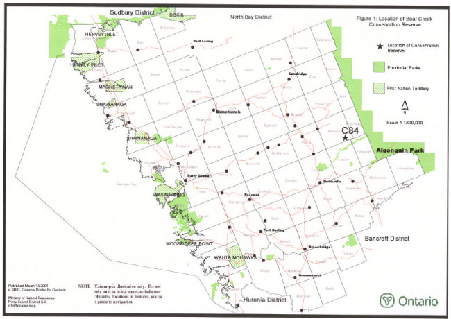
Enlarge Figure 1: Location of Bear Creek Conservation Reserve
Figure 2: Site Map of Bear Creek Conservation Reserve
Notes:
On generic policy application in conservation reserves:
1For direct retrieval of game only.
2Only as a part of an approved research project.
3Transfer requests will be considered in the context of the Statement of Conservation Interest or Resource Management Plan for each conservation reserve.
4Existing use is permitted to continue. New transportation corridors, communications lines, and transmission lines are discouraged in conservation reserves except under unusual circumstances where there are no other viable alternatives.
5New private roads, including additions to existing roads, will not be permitted except where there are existing commitments.
6Sale of Crown land in conservation reserves is not permitted, except for certain minor dispositions (e.g. sale of small parcel of land where adjacent private lot is too small to enable installation of a septic system, or to facilitate legal title to lands where there has been a long-standing encroachment of a dwelling on crown land) where they do not detrimentally affect the values an area is intended to protect.
On specific policy application in Bear Creek Conservation Reserve:
AFood gathering is permitted for personal consumption only and must be conducted in a sustainable manner, and such that it does not harm the values of the conservation reserve.
BExisting authorized recreational trails are permitted to continue in conservation reserves as long as there are no significant environmental impacts and they do not impair the natural features and values for which the area is identified. New recreational trails may be considered on a case by case basis provided that they meet the requirements identified in Section 3.3 of this document. New recreational trails for motorized uses are discouraged and will only be considered under exceptional circumstances if the criteria identified in Section 3.3 have been demonstrated.
CWhile existing authorized recreation camps within conservation reserves are generally permitted to continue, new recreation camps are not permitted.