Boom Creek Conservation Reserve Management Statement
This document provides policy direction for the protection, development and management of the Boom Creek Conservation Reserve and its resources.
Statement of Conservation Interest
Ontario Ministry of Natural Resources
North Bay District
March 2005
Approval Statement
We are pleased to approve this Statement of Conservation Interest (SCI) for Boom Creek Conservation Reserve (C124).
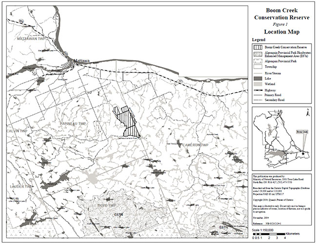
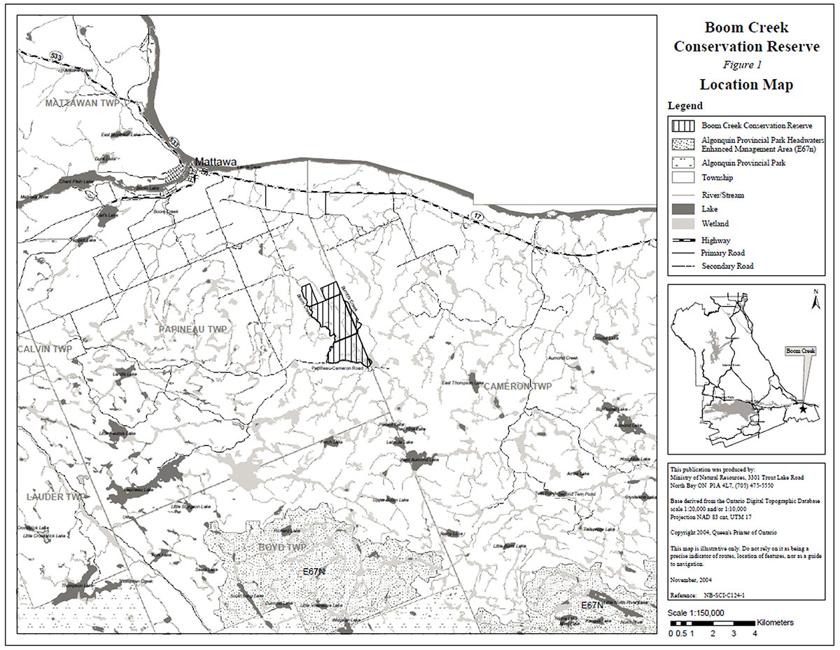
Boom Creek Conservation Reserve is located in Ecodistrict 5E-10 approximately 8 km southeast of Mattawa south of Highway 17 (figure 1). The boundary of the conservation reserve is located in the geographic townships of Papineau and Cameron within the Municipal Township of Papineau-Cameron in the District of Nipissing (figure 2). The conservation reserve is known to encompass significant life science values. A forest community of old growth red and white pine with sporadic wetland depressions is found within the site.
During the Lands for Life planning process the public was widely consulted and provided valuable input into what became Ontario’s Living Legacy. Boom Creek Conservation Reserve was recognized for protection during the Keep It Wild Campaign and in the Land Use Strategy and is now part of the Crown Land Use Policy Atlas. Comments received during that time, and during consultation related to the formal Public Lands Act regulation of the boundaries of this conservation reserve were generally supportive of the protection of this area.
Stakeholders who expressed an interest in the planning of this site were also notified regarding the draft SCI and given a two week review period. Any comments, including input from previous consultation, were considered in the finalization of this document. Little interest and no new issues or concerns were expressed by the public during the review of this draft SCI. The draft was reviewed by MNR district specialists located on area teams who are responsible for the management of particular areas within the district, which include this conservation reserve.
This basic SCI provides guidance for the management of the conservation reserve and the basis of the ongoing monitoring of activities. More detailed direction is not anticipated at this time. Should significant facility development be considered or complex issues arise requiring additional studies, more defined management direction or special protection measures, a more detailed Resource Management Plan will be prepared with full public consultation.
Boom Creek Conservation Reserve is managed under the direction of the District Manager and the Wasi Area Supervisor, North Bay District, Ministry of Natural Resources.
Prepared by:
Klara Vodicka
District Planning Intern
Date: March, 2005
Original signed by:
Bill Hagborg
Acting District Manager
North Bay District
Date: March 29, 2005
Original signed by:
Rob Galloway
Regional Director
Northeast Region
Date: April 5, 2005
1.0 Introduction
The purpose of this Statement of Conservation Interest (SCI) is to identify and describe the values of the Boom Creek Conservation Reserve. The SCI also outlines the activities that occur within the conservation reserve and provides guidelines for the management of current and future activities in the context of protecting the natural, social and cultural values of the conservation reserve. A SCI is prepared under the authority of Procedural Guideline A – Resource Management Planning (PL. Procedure 3.03.05).
Boom Creek Conservation Reserve is a 590 hectare parcel of Crown land located south of Highway 17, approximately 8 km southeast of the Town of Mattawa. The boundary of the conservation reserve is located in the geographic townships of Papineau and Cameron within the Municipal Township of Papineau-Cameron (figure 1). The old growth red and white pine forest is a notable feature. It provides optimal habitat for a variety of wildlife including many game species.
Conservation reserves are established by regulation under the Public Lands Act. Boom Creek Conservation Reserve was established by Ontario Regulation 208/03, under authority of the Public Lands Act (O. Reg. 805/94) on February 14, 2003. The planning area for this SCI is the regulated boundary of the conservation reserve.
1.1 Planning Context
Ontario’s Living Legacy Land Use Strategy was approved in 1999. The objectives of the Land Use Strategy are to complete Ontario’s system of protected areas; recognize the land use needs of resource-based tourism industry; provide forestry, mining and resource industries with greater certainty around land and resource use; and enhance hunting, angling and other Crown land recreational opportunities. Boom Creek Conservation Reserve was created as part of the expansion of protected areas.
Conservation reserves protect natural heritage values on public lands, while permitting compatible land use activities. By allocating these lands to the parks and protected areas system through regulation, the province has ensured a certain level of permanence by distinguishing the conservation reserve and its values from the larger general use or more extensively managed landscape. In addition, the conservation reserve’s natural features are, and will be available for present and future generations to enjoy and explore.
The Land Use Strategy (1999) and the Crown Land Use Policy Atlas outlines the general land use policy and management direction for new conservation reserves. Each new conservation reserve will have a planning document, either a SCI or, in more complex situations, a Resource Management Plan, that details site-specific management direction.
Comments received during the Lands for Life process, and during consultation related to the formal regulation of the boundaries of this site were generally supportive of the establishment of this area as a conservation reserve.
Although more detailed direction is not anticipated at this time, should significant facility development be considered or complex issues arise requiring additional studies, more defined management direction or special protection measures, a more detailed Resource Management Plan will be prepared with full public consultation.
1.2 Background Information
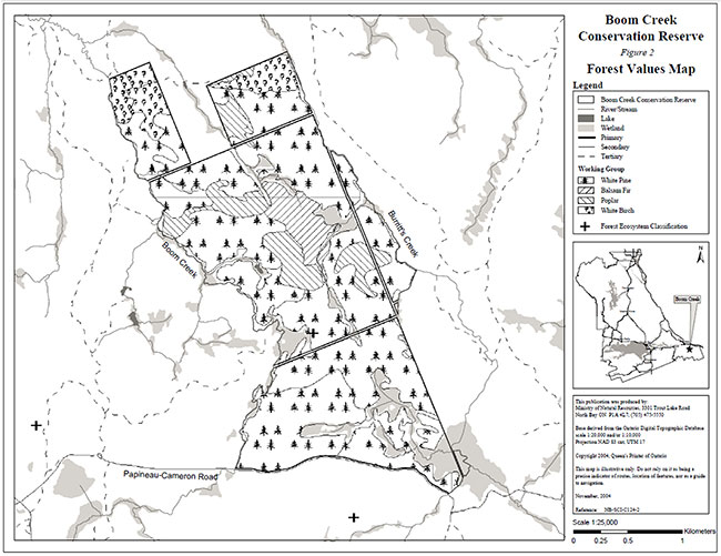
Boom Creek was first identified as a significant old growth forest site during the Keep it Wild Campaign, a program aimed at completing the province’s system of provincial parks and protected areas. Protection of this site was established through regulation as a conservation reserve in 2003. Boom Creek Conservation Reserve is an old growth forest located south of Highway 17, southeast of Mattawa. The site, formerly on the boundary of Ecodistrict 5E-5 and 5E-10 (Hills, 1959) now falls within Ecodistrict 5E-10 (Crins, 2000) in the revised version of Hills original Site Regions and Site Districts. The conservation reserve is surrounded by Crown land with some patent land that borders the vectored northern portion of the site. The southern portion of the conservation reserve is bordered by Papineau-Cameron Road, while the east and west sides of the site are bordered by Burritt’s and Boom Creeks respectively (figure 1). This 590 hectare area was protected in order to preserve the valuable life science features (figure 2). The area can be accessed at the southern portion of the conservation reserve via Papineau-Cameron Road.
The following chart summarizes administrative information for Boom Creek Conservation Reserve:
| Name and OLL ID Number | Boom Creek Conservation Reserve (C124) |
|---|---|
| Ecoregion/ Ecodistrict (Hills, 1959; Crins, 2000) | 5E Georgian Bay, 5E-10 Brent |
| OMNR Administrative Region/ District/ Area | Northeast Region/North Bay District/ Wasi Area |
| Total Area (ha.) | 590 |
| Regulation Date | February 14, 2003 (O. Reg. 208/03) |
| Township(s) | Papineau, Cameron |
| First Nations | Mattawa North Bay Algonquins – area of interest Antoine First Nation – area of interest |
| OBM map sheets | 2017 6800 51200 – 1017 6800 51250 |
| Topographic Map Name/ Number | Mattawa 31 L/7 and Kiosk 31L/2 |
| UTM coordinates | 683,500 m E 5,124,600 m N |
| General Location, Description, Access | Approximately 8 km southeast of Mattawa. Site contains old growth red and white pine forest. The site can be accessed via Papineau-Cameron Road at the southern boundary of the site. This secondary road is a snowmobile trail in the winter. |
1.3 Goals
The goals of this SCI are:
- To provide background information.
- To identify and describe the values of the conservation reserve.
- To provide guidelines for the management of current and future activities while protecting natural, social and cultural heritage values.
1.4 Objectives
The following objectives are identified as a means to achieve the above-stated goals.
- To describe the state of the resource with respect to natural heritage values and current land use activities.
- To manage the conservation reserve to protect the integrity of its natural values via specific guidelines, strategies and prescriptions.
- To meet planning requirements by addressing the management intent of the conservation reserve and addressing planning and management needs.
- To create a public awareness of the values within the conservation reserve and promote responsible stewardship of the protected area through partnerships with local stakeholders.
- To determine long-term management goals of the conservation reserve by identifying research, client services and marketing strategies.
- To identify scientific values on the site in relation to provincial benchmarks and identify the necessary monitoring and/or research to maintain the integrity of those values.
- To provide direction to evaluate new uses or economic ventures through the application of a Test of Compatibility (Procedural Guideline B) - Land Uses - PL. 3.03.05) (Appendix 1) and under MNR's Class Environmental Assessment for Provincial Parks and Conservation Reserves.
1.5 Representation
The following table provides a summary of the life science, earth science and cultural heritage values, as well as recreational opportunities.
| Life science representation: |
Thirteen forest communities can be found on a variety of topographic terrain and soil types. The following landform types and vegetation associations are found (Burdhardt et al., 2004):
|
|---|---|
| Earth science representation: | Boom Creek Conservation Reserve lies on highly deformed and metamorphosed bedrock of the Central Gneiss Belt of the Grenville Province of the Precambrian Shield. The area is characterized by glacial till and exposed bedrock. The predominant rock type is pink and grey granitic gneiss. The surficial layer is fairly flat to quite rocky and contains a variety of soil types ranging from clay to sand (OMAF, 1986). There are also low lying wetland depressions, ponds and streams present within the site. |
| Cultural heritage values: | Boom Creek Conservation Reserve was identified as containing high potential heritage areas within the site (see section 2.3). The conservation reserve is in the area of interest of Antoine First Nation and the Mattawa North Bay Algonquins. More in-depth research concerning cultural heritage values has not been completed to date. |
| Recreational opportunities: | The site offers a variety of recreational opportunities including; hunting of small game, large game and upland birds, snowmobile and ATV use, observation of old growth red and white pine, bird watching, potentially cross country skiing, and photography along Boom Creek. Fishing may also take place along the boundary of the conservation reserve in and Boom Creek (Sheppard, 2003). |
1.6 Survey Work
The following table provides an overview of inventories completed, their level of detail, and any further inventories that are required.
| Survey Level | Life Science | Earth Science | Cultural | Recreational |
|---|---|---|---|---|
| Reconnaissance | Burkhardt, B. et al. 2004, Life Science Checksheet Aerial Survey (In Progress) | Kristjansson, F.J.,2004, Earth Science Checksheet, Aerial Survey (In Progress) | First Nations Interviews, 1998 & 2003, Native Background Information Report and Values Maps, related to Forest Management Planning | Sheppard, C., 2003, Recreational Inventory Checklist, Aerial and Ground Survey |
| Detailed | None | None | None | None |
| Requirement | Monitor on on-going basis | None | None | Monitor on on-going basis |
2.0 State of the Resource
The conservation reserve is located entirely within Ecodistrict 5E-10 (Crins, 2000). Values include life science, earth science, cultural and recreational/aesthetic with an emphasis on the life sciences.
Significance is determined on the basis of the following criteria: representation, diversity, condition, ecological considerations and special features (Crins and Kor, 1998).
Representation:
Boom Creek Conservation Reserve is comprised of old growth red and white pine forest with some mixed deciduous and coniferous vegetation (photo 1). Small areas of wetland vegetation are also present surrounding Burritt’s Creek, Boom Creek and the ponds and marshes of the interior (figure 2).
There are 13 forest communities and a few wetland areas found within the interior of the site. The forest communities consist mostly of old growth red and white pine on the shallow sandy soils (photo 1). The northern portion of the site contains pine with an average age of 120-130 years. The southern portion of the site contains both older and younger pine each averaging 150-160 years and 70 years respectively. This old growth pine association is not well represented in existing protected areas within the Ecodistrict. The site contains mixed stands of spruce, poplar and white birch in the deeper more moisture rich areas. Some of the regeneration species in more open areas include pine, maple, poplar, balsam fir, and spruce. There are many herbaceous species present in the understory of this forest including bracken fern, star flower, bunch berry, large leaf white violet and sheep laurel. Wetland vegetation surrounds and Boom Creek that border the site, and the interior low lying ponds and streams.
Diversity:
Diversity is a measure of the conservation reserve’s earth and life science variety. The evaluation is based on the number and range (assortment) of landscape features and landforms for earth science values and the relative richness and evenness of the site’s life science components.
Boom Creek Conservation Reserve has a low diversity rating because of the limited number of species present within the site. These species include old growth red and white pine, a forest community that is not well represented within the Ecodistrict. A few wetland areas, surrounding ponds and streams within the interior of the site also add to the diversity of the site. There are more diversified vegetation types along the edges of the conservation reserve near both Burritt’s and Boom Creeks. These wetland areas only make up approximately 1% of the site.
Condition:
Overall the conservation reserve is in good condition with respect to its natural features. The disturbance for the area has been rated as low. Due to the proximity of the conservation reserve to Boom Creek and the Ottawa River, and the present age and species mixture, it is likely the area was horse logged for the white pine square timber trade in the early 1900's. Since then, the forest within Boom Creek Conservation Reserve has remained relatively undisturbed. Logging has not occurred within the site in the last 15 years. However, there have been forest management and logging activities adjacent to the site. There is no known fire disturbance greater than 200 hectares in size in the area since the 1920's. Other natural disturbances such as beaver activity may be present adjacent or near the site due to the surrounding creeks and small wetland areas within the conservation reserve. Recreational uses within the conservation reserve include hunting, snowmobiling (photo 2) and ATV use, bird watching, old growth observation and potentially cross country skiing, and photography. A variety of authorized commercial activities such as baitfishing, trapping and bear management also occur in and around the area. All of these activities are believed to have little impact on the core ecological values of the site.
Ecological Considerations:
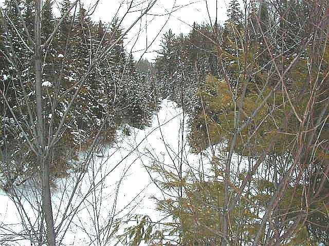
Boom Creek Conservation Reserve is a small 590 hectare area comprised of Crown land. The conservation reserve is bordered by patent land to the north and Crown land on all other sides. The site maintains natural ecological boundaries with Boom Creek (photo 3) to the west and Burritt’s Creek to the east. Papineau- Cameron Road borders the southern portion of the site while the north is bordered by vectored boundaries of surrounding patent land. The core interior values for which the site was established, the old growth forest, are included within the site and are thus protected. The surrounding areas are presently well forested. Both the conservation reserve and surrounding areas are frequently utilized for hunting small and large game.
Special Features:
The most unique feature within the conservation reserve is that it contains an abundance of old growth forest. This mature coniferous forest provides habitat for a variety of wildlife species.
White pine provides habitat for a variety of species such as deer and moose. The bones of numerous animals, which appear to be both small and large game were spotted at Boom Creek. There are signs of human disturbance associated with hunting. Black bears are known to commonly use large pine as refuge trees and bedding sites.
The crowns of supercanopy pine offer ideal nesting and perch sites for species such as bald eagles and osprey. Great blue herons also enjoy nesting in undisturbed mature coniferous forest that is located in close proximity to foraging areas such as marshy lakes. A great blue heron nest has been identified within the site. Certain species of woodpeckers, songbirds, hawks and owls also prefer older growth forests to more immature forests.
Insects including dragonflies and beetles are known to appear more frequently and in greater variety in old growth forests. As the old growth trees die and decay they continue to add diversity to the site. Snags provide nesting, foraging and denning sites for numerous species of birds and mammals. Fallen tree trunks provide shelter and foraging grounds for small mammals, salamanders and arthropods. Many types of lichens and fungi also grow in these areas, these species are known be more diverse in old growth areas compared to less mature areas.
The site is surrounded by Burritt’s Creek and Boom Creek. Burritt’s Creek is considered a cold water fishery, which is conducive to the needs of Brook Trout a highly prized game species. Brook Trout have also been found in sections of Boom Creek and in small streams abutting the conservation reserve. Thus, the boundaries of the conservation reserve may be utilized for fishing. The interior of the site encompasses a few small ponds and streams. These areas may provide additional fishing opportunities.
2.1 Life Science
Gap analysis is a method of identifying gaps in representation of all landform/vegetation features within the Ecodistrict, and to identify potential sites that best fill those gaps. The objective of gap analysis is to complete representation of all vegetation community and landform types within protected areas (Bergsma, 1995). Boom Creek Conservation Reserve was not identified through gap analysis, but was originally identified as a potential candidate site during the Keep it Wild Camgaign (1994) in an effort to fulfill the governments commitment to preserving old growth red and white pine. This area was chosen based on representative, genetic, historical and aesthetic values and its potential to help complete Ontario’s system of natural protected areas.
The conservation reserve consists mainly of old growth red and white pine forest with some mixedwood forest. The supercanopy pine provides habitat for a variety of wildlife including many small and large mammals and upland birds. The presence of interior wetland areas and those that surround the bordering creeks also add diversity to site.
2.2 Earth Science
Boom Creek Conservation Reserve lies on highly deformed and metamorphosed bedrock of the Central Gneiss Belt of the Grenville Province of the Precambrian Shield. The area is characterized by glacial till and exposed bedrock. The predominant rock type is pink and grey granitic gneiss. The site contains a variety of soil types interspersed with marshy wet areas, ponds and streams. The northern portion of the site contains moderately stony, undulating to moderately rolling topography with a sandy loam soil. The northwestern edge is made up of a mixture of level non stony clay loam soil and undulating non stony sandy loam soil. The northeastern edge is made up of non stony very gently sloping deltaic sand outwash material. The southern and middle portion of the conservation reserve contains 70% very stony moderately sloping sandy loam till and 30% slightly stony undulating sandy loam. There is also a section of undulating rocky sandy loam at the southeastern part of the site (OMAF, 1986a & 1986b).
2.3 Cultural Values
There are no archeological sites identified within the conservation reserve. There are some identified high potential heritage areas. High potential cultural heritage areas are identified using a computer based predictive modeling program. Based on a series of pre-defined parameters, the program identifies candidate areas, which are most likely to be culturally significant. The conservation reserve is within the area of interest of Antoine First Nation and the Mattawa North Bay Algonquins. More in-depth research concerning cultural heritage values has not been completed to date.
2.4 Recreational/Aesthetic Values
Boom Creek Conservation Reserve has historically been a popular area for recreational hunting. The site is located in close proximity to the town of Mattawa and the larger city center of North Bay. The most popular recreational activity within Boom Creek Conservation Reserve is the hunting of large and small game and upland bird species. The area is known for its hunting appeal due to the many deer, moose and bear that are present within the area. Some waterfowl hunting may also take place along the creeks that surround the site. Local residents are known to frequent the site along with some bear guide tourist operators. A trail leads into the northern portion of the site. However, this trail crosses private land and is thus not accessible from outside the conservation reserve. Access to the site can be achieved via Papineau-Cameron Road that extends across the southern boundary of the site. This road is accessed via smaller roads that join up to Highway 17. Papineau-Cameron Road also serves as a secondary road in the summer and a popular recreational snowmobile trail in the winter. Other recreational activities that may also take place within this aesthetically pleasing remnant old growth forest include birdwatching, cross country skiing, hiking, photography, wildlife viewing and general nature study. Fishing may also occur along the creeks (Burritt’s and Boom Creek) that form the boundaries of the conservation reserve. Brook Trout, a valued game species, has been found in Burritt’s Creek and in small abutting streams. The current and possible future recreational activities are believed to have a limited impact on the integrity of the site and thus will be permitted to continue.
2.5 Heritage Estate Contributions
The conservation reserve has been set aside in order to protect the unique life science features associated with the site. The site was identified as possessing significant life science values through the Keep it Wild Campaign and reaffirmed during the Lands for Life planning process. Key features include:
- Old growth red and white pine forest
- Wide variety of wildlife including moose, deer and bear
The protection provided through designation as a conservation reserve will help ensure the preservation of the site for future generations. Additional values and features not described here can be found in sections 2.0 and 2.1. Should a new, significant key value be identified, current management guidelines may be modified to ensure its protection.
3.0 Management Guidelines
3.1 Management Planning Strategies
The land use intent outlined in Ontario’s Living Legacy Land Use Strategy provides context and direction to land use, resource management, and operational planning activities on Crown land. Commitments identified in the above strategy and current legislation (PL Procedure 3.03.05) will form the basis for land use within Boom Creek Conservation Reserve. For up-to-date information on permitted uses refer to the Crown Land Use Atlas at /page/crown-land-use-policy-atlas.
Existing permitted uses within the conservation reserve may continue, unless they are shown to have a significant negative impact on the values within the site.
Proposed uses and development within the conservation reserve will be reviewed on a case-by-case basis. A Test of Compatibility (Appendix 1) must be passed before they are deemed acceptable. The emphasis will be on ensuring that the natural values of the conservation reserve are not negatively affected by current or future land use activities. Therefore, any application for new specific uses will be carefully studied and reviewed. The Ministry, partner organizations and/or proponents may undertake such studies. Requirements under MNR's Class Environmental Assessment for Provincial Parks and Conservation Reserves will also be met.
3.2 Land Tenure
Background:
Boom Creek Conservation Reserve consists entirely of Crown land. The site is almost entirely surrounded by Crown land and waters except for a section of patent land adjacent to the northern border of the site. The private land that surrounds the conservation reserve is utilized for agricultural and recreational purposes.
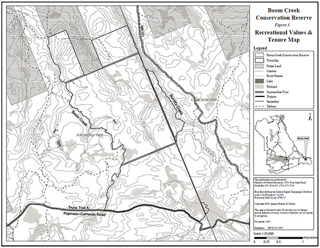
There are no recreation camps or land use permits within Boom Creek Conservation Reserve. However, there is an OFSC trail that borders the southern edge of the site.
Guideline:
The sale of Crown lands within the conservation reserve is not permitted.
New recreation camps are not permitted.
Unauthorized occupations of lands within the conservation reserve will be handled in accordance with approved policy, and any required structural removal will be at the owner’s expense.
3.3 Development and Access
Background:
The site can be most easily accessed via Papineau-Cameron Road. This road runs along southern boundary of the conservation reserve and provides both summer and winter access. The road can be accessed using Donald Street on the west side of Mattawa and Dorian Street from the southeast side of Mattawa. Winter access is achieved via snowmobile when the road becomes an Ontario Federation of Snowmobile Clubs (OFSC) TOP Trail (photo 2). There is a trail/tertiary road that runs along the northern portion of the site, however this road/trail cannot be accessed because it extends from and crosses patent land. In addition, there are many other tertiary and logging roads situated on both Crown and private land on the outskirts of the conservation reserve. Other roads may provide limited access to the outer boundary edges of the site by car, foot or ATV, although there are no authorized ATV trails within the conservation reserve. Many of these tertiary roads extend from Highway 17 which runs north and east of the site. Access can also be achieved by water via and Boom Creek located along the eastern and western boundary respectively. There are no known campsites, buildings, facilities, utilities or other structures within the conservation reserve.
Guideline:
New roads for resource extraction and/or private use will not be permitted, nor will additions to existing roads or upgrading of existing private roads.
New trails are not encouraged, however they may be considered when compatible with other recreational uses and the maintenance of environmental integrity. Any new trail development must go through a Test of Compatibility to ensure the quality of the life and earth science representation and any additional values (e.g. aesthetics, landscape views, sensitive areas) are maintained.
Consideration for new snowmobile trails will occur on a case-by-case basis, but will not be encouraged. Public consultation will be an important part of the process.
In the case of ATV's, the demand, as well as the environmental impact of this activity, will be determined before specific trails are designated or constructed. In general, ATV trails will be discouraged.
The use of existing unauthorized trails will be monitored to ensure that conservation reserve values are not being adversely impacted. Depending on the results of the monitoring, some of the unauthorized trails may need to be redirected from sensitive areas, or eliminated completely.
In the future, the district may consider developing a trails strategy to ensure the values within the conservation reserve are fully protected, while maintaining current permitted uses. Access to resources will include both direct access (e.g. current roads or trails) and/or more remote access (e.g. waterways) opportunities. Such planning could include public consultation.
Facility infrastructure and development for recreation may be considered in the future if there is a demonstrated need for such facilities. A more detailed management plan would be required prior to construction.
3.4 Recreational Activities
Background:
Existing recreational activities include hunting of large game, small game and upland birds. Hunting is a popular recreational activity especially for large game such as deer, moose, bear and some upland birds such as the partridge. Hunters have a special interest in the area due its proximity to Algonquin Park, a haven for many large game species. Snowmobiling is a popular activity known to occur along the southern boundary of the site along Papineau-Cameron Road, an OFSC TOP Trail in the winter. Other recreational activities, such as general nature appreciation, may also occur within the conservation reserve.
Guideline:
Most recreational activities that have traditionally been enjoyed in this area can continue, provided they pose no threat to the natural ecosystems and features protected by the conservation reserve.
Mechanized travel is permitted only on existing trails. Off-trail mechanized travel is permitted for retrieval of game only.
New recreational activities will be considered on a case-by-case basis. Emphasis will be placed on activities that have a low impact on the environment of the conservation reserve.
3.5 Industrial Activities
Background:
Boom Creek Conservation Reserve is located within Nipissing Forest, managed by Nipissing Forest Resource Management Incorporated, by a Sustainable Forest License. The conservation reserve has been removed from the licensed area.
There are no existing mining, timber harvesting, aggregate extraction or utility activities within the conservation reserve.
Mining and surface rights have been withdrawn from staking within the conservation reserve under the Mining Act (RSO Chapter M.14).
Guidelines:
Conservation reserve regulations do not permit mining, commercial forest harvesting, hydroelectric power development, the extraction of aggregate and peat or other industrial uses (Conservation Reserves Policy PL 3.03.05 governed the Public Lands Act, Ontario Regulation 805/94).
3.6 Commercial Activities
Background:
The conservation reserve includes part of registered traplines NB-48 and NB-59. There are two active baitfish licenses for both Cameron and Papineau Township. The conservation reserve encompasses a portion of Bear Management Area (NB-48-06). The Ministry of Natural Resources authorizes these activities.
Guideline:
Existing non-industrial commercial uses such as trapping and baitfish harvesting will be permitted to continue. These activities will continue to be monitored in order to ensure they do not deplete natural resources and pose a minimal impact on the features identified for protection.
New non-industrial commercial activities (i.e. traplines) which overlap with the conservation reserve may be considered subject to a Test of Compatibility (Appendix 1), consistent with provincial direction. Any new trails associated with the new non-industrial commercial activities must also be considered subject to a Test of Compatibility.
New trap cabins will not be permitted in the conservation reserve.
Existing commercial bear hunting operations are permitted to continue but the introduction of new operations will not be allowed.
The issuance of Licenses to Provide Bear Hunting Services will be allowed where areas have been licensed or authorized under agreement for the activity since January 1, 1992 (there must be documentation in Ministry files that commercial bear hunting has been licensed during the period January 1, 1992 to present) unless:
- The Government has taken action to discontinue the activity; or
- Proceeding would create/aggravate resource sustainability issues (e.g., wildlife management reasons, imparts on values); or
- Licensing or permitting should be deferred due to Aboriginal issues.
Licenses to Provide Bear Hunting Services will not be issued in areas where issuance has not occurred since January 1, 1992.
3.7 Aboriginal Interests
Background:
This site is located within the area of interest the Mattawa North Bay Algonquins and Antoine First Nation. In addition, the Mattawa North Bay Algonquins are currently in a land claim negotiation with Ontario and Canada. There are identified high potential heritage areas within the conservation reserve.
Guideline:
All aboriginal and treaty rights will continue to be respected and are not affected by the establishment of this conservation reserve.
Any future proposals or decisions that have potential impact(s) on individual or aboriginal or community values will involve additional consultation with the affected aboriginal groups.
3.8 Natural Resource Stewardship
Background:
Boom Creek Conservation Reserve encompasses old growth coniferous forest. This red and white pine forest contains pine ranging from 70 to 160 years of age. This old growth association is not well represented in existing protected areas in this Ecodistrict and is thus notable.
Based on the Ecosite Classification of Boom Creek Conservation Reserve the onset of old growth for this site is 150 years for white pine and 140 years for red pine. An old growth forest can only retain its old growth properties for a limited period of time before succession takes place and the nature of the community is fundamentally changed. Once the pine has reached the age where it may be considered old growth, the community has another 80-160 years for white pine and 50-100 years for red pine, until the old growth pine is succeeded by a hardwood forest consisting of spruce, balsam and poplar (Uhlig et al., 2001). In a natural system the site may retain its pine species composition through the occurrence of natural disturbance such as a fire, insect infestation or a blow down.
Boom Creek Conservation Reserve is also an important area for wildlife. The site provides excellent habitat for deer, moose, bear and various upland bird species. The conservation reserve offers outstanding hunting and nature study opportunities.
Guideline-Vegetation:
The conservation reserve will be managed by allowing natural ecosystems and processes to function as they would with minimal human interference.
The MNR recognizes fire as an essential process fundamental to the ecological integrity of conservation reserves. Fire disturbance is accepted as part of the life regeneration cycle of the natural forested landscape. MNR recognizes the need for forest fire disturbance to maintain the old growth forests which contribute to the ecological diversity and thus sustainability of the larger Ontario landscape.
Prescribed burning may be utilized to emulate natural disturbances and renew forest communities, prepare seed beds for research and/or education purposes or to meet additional objectives determined within a separate vegetative management plan. All scheduled prescribed burns within the boundaries of a conservation reserve will consider factors such as fuel type, topography or slope, weather, ignition source and land use values and will be conducted as directed by the current Prescribed Burn Policy AF.03.23.02.
Ecological or resource management objectives will be developed with public consultation prior to any prescribed burning, and reflected in a document that provides further management direction for this conservation reserve. Plans for any prescribed burn will be developed in accordance with the MNR Prescribed Burn Planning Manual, and the Class Environmental Assessment for Provincial Parks and Conservation Reserves.
In accordance with existing Conservation Reserve Policy and the Forest Fire Management Strategy for Ontario, forest fire protection will be carried out as on surrounding lands. In general, natural forest fires will be suppressed using low impact fires suppression techniques in order to protect human life and property. Whenever feasible, the MNR fire program will endeavor to use "light on the land" techniques, which do not unduly disturb the landscape, in this conservation reserve. Examples of light on the land techniques may include limiting the use of heavy equipment or limiting the number of trees felled during fire response efforts.
Personal use permits for wood harvesting are not permitted.
Programs may be developed to control forest insects and diseases in the conservation reserve, where these threaten significant values in or adjacent to the site. Where insects or disease threaten significant values, in or adjacent to the site, control will be directed as narrowly as possible to the specific insect or disease. Biological control will be used whenever possible. Regard shall be had for the Test of Compatibility.
Guideline-Fish and Wildlife:
Fish and wildlife resources will continue to be managed in accordance with policies and regulations prevailing in the area and under the direction of the Wasi Area Supervisor. Provincial legislation and policy will dictate management and enforcement objectives for this area.
3.9 Cultural Resource Stewardship
Background:
There have been no specific studies or inventories undertaken by the MNR within the conservation reserve and no specific cultural resource values that have been evaluated or identified to date. However, areas of high potential heritage have been identified within the site.
Guideline:
Should the MNR consider new structural development, significant clearing of vegetation or altering of land within this conservation reserve, the MNR will adhere to the cultural heritage resource screening process as is identified in its Memorandum of Understanding (MOU) with the Ministry of Culture (MCL). While the purpose of this MOU is to provide a process to identify and protect cultural heritage resources when the MNR is reviewing work permits or disposing of Crown rights under the authority of the Public Lands Act, the considerations and criteria would also enable the MNR to identify high potential cultural heritage areas for other purposes within conservation reserves. If the screening process indicates that the site of a proposed activity is within an area of high cultural heritage potential, the MNR will consult with the MCL to determine the appropriate cultural heritage assessment requirements and will undertake a preliminary archaeological assessment if appropriate.
3.10 Client Services
Background:
There are currently no client services associated with this conservation reserve.
Guideline:
The focus will remain on low key information and self-interpretation of conservation reserve features. Messages should focus on the area’s natural heritage features, recreation opportunities, nature appreciation and education.
Information regarding the Boom Creek Conservation Reserve may be delivered from different sources, however, MNR will be the lead agency for responding to inquiries. A management agreement may be pursued with an appropriate partner to share responsibilities for information services and the delivery of other aspects of this SCI.
Consideration will be given to the strategic location of signs where roads or trails cross the conservation reserve boundary. There are no other plans for structural development within this conservation reserve.
3.11 Monitoring, Assessment and Research
Background:
Research and assessment to date has included an earth science, life science and recreation checksheets. Since recommendations were provided, these checksheets have been used in the assessment of this site.
There is one Forest Ecosystem Classification (FEC) plot within the boundaries of the conservation reserve. This plot will be monitored on an ongoing basis, as it provides valuable information pertaining to plant ecology and forest growth characteristics. This benchmarked information provides trend through time data that managers may use to identify and predict the effect of management strategies on similar landscapes. These types of plots exist throughout the province.
Guideline:
Consideration will be given to inventory and documentation of natural and cultural values, and the assessment of use/activity impacts. The compatibility of current and future FEC plots may be reviewed to ensure they conform to the protection of values and are unobtrusive to other activities conducted within the conservation reserve. All research will be carried out in a non- destructive manner. Research proposals must follow Procedural Guideline C – Research Activities in Conservation Reserves (PL 3.03.05).
The collection/removal of vegetation and parts thereof will not be permitted; however, subject to a Test of Compatibility (Appendix 1), the Area Supervisor may authorize the collection of plants and/or parts for purposes of rehabilitating degraded sites within the conservation reserve and collecting seeds for maintaining genetic stock or research.
Research, education and interpretation will be encouraged to provide a better understanding of the management and protection of the natural heritage values and will be fostered through local and regional natural heritage programs, initiatives and partnerships.
3.12 Marketing
Background:
There has been no marketing of this conservation reserve to date. Promotion and information about this site has been primarily through the Ontario’s Living Legacy planning process and public consultation regarding the boundaries of this site.
Guideline:
Marketing activities of this conservation reserve will be kept to a minimum.
4.0 Implementation
Implementation of the SCI and management of the conservation reserve are the responsibility of the Wasi Area Supervisor, North Bay District of the Ministry of Natural Resources.
Emphasis will be placed on awareness information highlighting conservation reserve values and appropriate uses.
Long term management will consider balancing the needs of recreation and other users while maintaining the quality of the representation of the resource.
5.0 Review and Revision of the Statement of Conservation Interest
Boom Creek Conservation Reserve SCI will be reviewed on an ongoing basis and will include the monitoring of activities to ensure adherence to management guidelines. Partnerships may be pursued to address management needs.
This SCI will be amended through a standard process of minor and major amendments. Minor amendments will be processed in a relatively informal manner and will require the approval of the Wasi Area Supervisor. These amendments will deal with uses and activities that do not affect any of the policies in this SCI (e.g. new uses and/or activities that are consistent with existing permitted uses).
Uses and/or activities that were not anticipated in the approved SCI and which may have an impact on the values of the conservation reserve will require a major amendment. This will include an opportunity for public comment and input and will require the approval of the North Bay District Manager and Regional Director.
6.0 References
Bergsma, B. et al. 1995. Gap Analysis and Candidate Area Selection for Life Science Representation in Site District 5E-6. Ecological Services for Planning Limited.
Burkhardt, Barbara et al. 2004, Life Science Inventory Checklist Site District 5E-10, Boom Creek Conservation Reserve. (In Progress)
Chambers, B.A., Naylor, B.J., Merchant, B. and Uhlig, P. 1997. Field Guide to Forest Ecosystems of Central Ontario.
Crins, W.J. and Uhlig, P.W.C. 2000. Ecoregions of Ontario: Modifications to Angus Hills' Site Regions and Districts. Unpublished Paper. Peterborough: OMNR.
Crins, W. J. and Kor, P. S. G. 1998. Natural Heritage Gap Analysis Methodologies Used by the Ontario Ministry of Natural Resources. Unpublished Paper. Peterborough: OMNR.
EMR Canada. 1996. Topographic Map 1:50,000. Kiosk. Sheet 31 L/2. EMR Canada. 1984. Topographic Map 1:50,000 Mattawa, Sheet 31 L/7
First Nations Interviews. 1998 & 2003. Native Background Information Report and Values Maps related to Forest Management Planning.
Hills, G.A. 1959. A Ready Reference to the Description of the Land of Ontario and its Productivity. Ontario Department of Lands and Forests, Division of Research, Maple, Ontario.
Kristjansson, F.J., 2004. Earth Science Inventory Checklist Site District 5E-10, Boom Creek Conservation Reserve. (In Progress)
Ontario Ministry of Agriculture and Food (OMAF). 1986a. Soils of North Bay Area Ontario Soil Survey Report No. 54 1:50,000. Kiosk 31 L/2.
OMAF. 1986b. Soils of North Bay Area Ontario Soil Survey Report No. 54 1:50,000. Mattawa 31 L/7.
Ontario Ministry of Natural Resources (OMNR). 1989. Aerial Photos. OMNR. 1997. Public Lands Directive Manual: Natural Heritage- PL 3.03.05.
OMNR. 1999. Ontario’s Living Legacy: Land Use Strategy. Peterborough: Queen’s Printer for Ontario.
OMNR. North Bay District. 2003. C124 Boom Creek Conservation Reserve File. Sheppard, C. 2003. Boom Creek Conservation Reserve Recreational Inventory Checklist.
Uhlig, P. A. et al. 2001. Old Growth Forest Definitions for Ontario. OMNR. Queens Printer for Ontario.
Photos of Boom Creek Conservation Reserve (C124)
Photo 1: Old growth white pine within Boom Creek Conservation Reserve
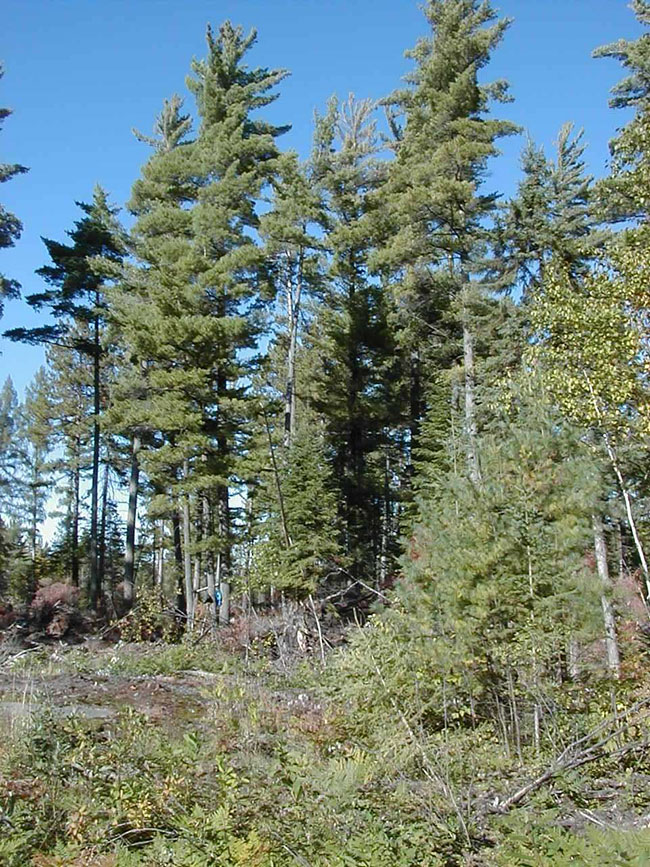
Photo 2: Individuals snowmobiling on a OFSC TOPS A Trunk Trail, along the southern boundary of the conservation reserve
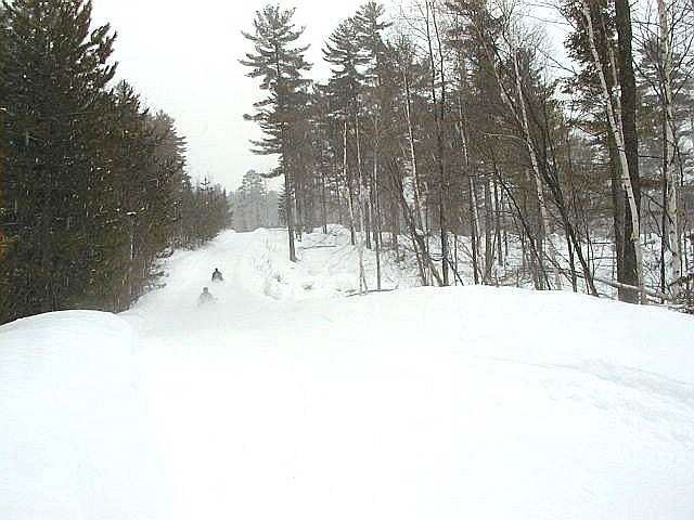
Photo 3: Winter photograph of Boom Creek, the eastern border of the conservation reserve
Appendix 1
Procedural Guideline B – Land Uses – Test of Compatibility (PL Procedure 3.03.05)
The Conservation Reserve policy provides broad direction with regard to the permitted uses. The policy provides only an indication of the variety of uses that will be considered acceptable in conservation reserves. The only caution is that "any new uses, and commercial activities associated with them, will be considered on a case by case basis, and, they must pass a test of compatibility to be acceptable." What does a 'test of compatibility' mean?
An examination of this must start from the premise of why an area is set aside – specifically, its representative natural heritage values. Criteria are then identified to guide compatibility considerations. These criteria apply to the long-term acceptability of both existing uses and new uses.
1. Conformity to SCI/RMP: SCI describe values for which an area has been set aside and the range of appropriate uses that will be permitted in the area. SCI may also speak to the acceptability of other 'new' uses currently not occurring in the area.
The first 'test' is: "do proposed new land uses and/or commercial activities conform to the direction of the SCI/RMP for the conservation reserve? Would the new use(s) depart from the spirit of appropriate indicator land uses in the SCI/RMP?"
2. Impact Assessment: If the proposed use(s) pass test 1 it is important to determine their impact on the area before they are approved. This should include the following:
- Impact on natural heritage values: "will the new use(s) impact any natural values in the area? If so how and to what degree? Is it tolerable?"
- Impact on cultural values: "will the new use(s) impact an historical or archaeological values in the area?"
- Impact on research activities: "will the new use(s) affect research activities in the area?"
- Impact on current uses: "will the new use(s) have any negative impact on the array of current uses?"
- Impact on area administration: "will the new use(s) increase administrative costs and/or complexity?" (For example, the cost of area monitoring, security and enforcement).
- Impact on accommodating the use outside the conservation reserve: "Could the use(s) be accommodated as well or better outside the conservation reserve?"
- Impact on socio-economics of the area: "will the new use(s) affect the community(ies) surrounding the area in a positive or negative way?" (For example, will the new use make an area less remote thereby affecting a local tourism industry that is dependent on the area’s remoteness for its appeal?"
- Impact on area accessibility: "does the new use(s) give someone exclusive rights to the area or a portion of the area to the exclusion of other existing uses?"
The following table provides a guide of indicator uses for the consideration of uses that may be permitted within conservation reserves. For any specific conservation reserve that test of compatibility should be applied to determine which specific uses are acceptable.
Appendix 2 - Public Lands Act Policy (3.03.05) Conservation Reserve Permitted Use Table
Indicator Uses for Conservation Reserves
Recreation
| Permitted Activities | Generic Existing | Generic New | (C124) Specific New Uses |
|---|---|---|---|
| Sport fishing | Yes | Yes | Yes |
| Sport hunting | Yes | Yes | Yes |
| Food gathering | Yes | Yes | Yes |
| Facility infrastructure | Maybe | Maybe | Maybe 1 |
| Non-trail snowmobiling | Maybe 1 | Maybe 1 | Maybe 2 |
| Non-trail ATV use | Maybe 1 | Maybe 1 | Maybe 2 |
| Rock climbing/caving | Maybe | Maybe | N/A |
| Canoeing/kayaking | Maybe | Maybe | N/A |
| Motorized boating | Maybe | Maybe | N/A |
| Picnicking | Yes | Yes | Maybe 1 |
| Camping | Maybe | Maybe | Yes |
| Trails | Yes | Maybe | Maybe 1 |
| Hiking | Yes | Maybe | Maybe 1 |
| X county skiing | Yes | Maybe | Maybe 1 |
| Cycling | Yes | Maybe | Maybe 1 |
| Horse riding | Yes | Maybe | Maybe 1 |
| Snowmobiling | Yes | Maybe | Maybe 1 |
| M1= New uses will be considered on a case by case basis provided they do not impact the natural heritage values for which the area was established, and must pass a test of compatibility to be acceptable. M2= For retrieval of game only |
|||
Science, education & heritage appreciation
| Permitted Activities | Generic Existing | Generic New | (C124) Specific New Uses |
|---|---|---|---|
| Research | Yes | Yes | Yes |
| General walking | Yes | Yes | Yes |
| Photography and painting | Yes | Yes | Yes |
| Wildlife viewing | Yes | Yes | Yes |
| Outdoor education/interpretation | Yes | Yes | Yes |
| Collecting | No | No | No |
Commercial activities
| Permitted Activities | Generic Existing | Generic New | (C124) Specific New Uses |
|---|---|---|---|
| Food harvesting | Maybe | Maybe | No |
| Fishing | Maybe | Maybe | No |
| Baitfish harvesting | Yes 1 | Maybe | Yes |
| Trapping | Yes 1 | Maybe | Yes |
| Trap cabins | Yes | No | No |
| Resort-outpost camp | Yes 1 | No | No |
| Outfitting-bear management | Yes 1 | No | Yes |
| Wild rice harvesting | Yes | Maybe | N/A |
| Y1= Transfer requests will be considered in the context of a Statement of Conservation Interest (SCI) or Resource Management Plan (RMP) for each conservation reserve. | |||
Resource management
| Permitted Activities | Generic Existing | Generic New | (C124) Specific New Uses |
|---|---|---|---|
| Inventory monitoring | Yes | Yes | Yes |
| Featured species management | Maybe | Maybe | Maybe |
| Natural systems management | Maybe | Maybe | Maybe |
Industrial activities
| Permitted Activities | Generic Existing | Generic New | (C124) Specific New Uses |
|---|---|---|---|
| Timber harvesting | No | No | No |
| Prospecting | No | No | No |
| Mining | No | No | No |
| Hydro generation | No | No | No |
| Energy transmission corridors | Yes | No | No |
| Communications corridors | Yes | No | No |
| Transport corridors | Yes | No | No |
| Resource roads (MNR) | Yes | No | No |
| Land disposition | * | No | No |
| Hunt camps | Yes 1 | No | No |
| *=Existing dispositions will continue, however, as opportunities arise the Ministry will acquire and/or remove them outside of the conservation reserve. Y1= Transfer requests will be considered in the context of a Statement of Conservation Interest (SCI) or Resource Management Plan (RMP) for each conservation reserve. |
|||
Appendix 3 – Glossary of Terms
Arthropods: Any of numerous invertebrate animals of the phylum Arthropoda, including the insects, crustaceans, arachnids, and myriapods, that are characterized by a chitinous exoskeleton and a segmented body to which jointed appendages are articulated in pairs2
Canadian Shield: One of the world’s largest, low relief areas in the Earths crust that are composed of Precambrian crystalline rock, centered on Hudson’s Bay and extending for 8,000,000 square km1
Cultural Heritage: Collective term describing examples of a society’s evolution (e.g. history, anthropology and archaeology) worthy of study and preservation5
Cultural Resources: Sites, features or artifacts related to the Province’s archaeology, anthropology or history, preserved in a natural setting5
Ecodistrict: An ecological landscape unit (ranging in resolution in hundreds of square kilometers) characterized by a distinct patterns in landform8
Ecoregion: An ecological landscape unit (ranging in resolution from hundreds of thousands to tens of thousands of square kilometers) characterized by distinct patterns of responses to climate as expressed by soils, hydrology, vegetation (species ranges and productivity), and fauna7
Forest Ecosystem Classification Plot (FEC): 100M2 (10m x 10m) research plot used by MNR to sample forest cover types. Information obtained during FEC sampling provides important information on the overstorey species composition, stand structure and the understory vegetation and soil-site characteristics. Resource managers use this data to help manage and conserve forested ecosystems and landscapes. Also, these permanent plots provide an opportunity to monitor forest change over time10
Gneiss: A crystalline rock, consisting, like granite, of quartz, feldspar, and mica, but having these materials, especially the mica, arranged in planes, so that it breaks rather easily into coarse slabs or flags2
Grenville Province: The area of Precambrian bedrock composed of certain metasedimentary and metavolcanic rocks located in the Canadian Shield or Georgian Bay-Ottawa Valley region4
Granite: A common, coarse-grained, light-colored, hard igneous rock consisting chiefly of quartz, orthoclase or microcline, and mica, used in monuments and for building2
Herbaceous: Relating to or characteristic of an herb as distinguished from a woody plant. Green and leaflike in appearance or texture2
Loam: Soil composed of a mixture of sand, clay, silt, and organic matter2
Metamorphosed: To change into a wholly different form or appearance; transform. Subject to metamorphosis or metamorphisM2
OBM: Ontario Base Map, refers to a geographic division of Ontario according to lines of longitude into mapsheets based on the UTM map projection system6
Outwash: Deposit of sand and gravel carried by running water from the melting ice of glacier and laid down in stratified deposits1
Overstory: The uppermost layer of foliage that forms a forest canopy2
Patent: An exclusive right or title2
Precambrian: All of geologic time older than the Cambrian Period, that is, older than 600 million years9
Prescribed burning: The deliberate, planned and knowledgeable application of fire by authorized personnel and in accordance with MNR policy and guidelines to a specific land area to accomplish pre-determined forest management or land management objectives3
Till: The heterogeneous mixture of clay, sand, pebbles and boulders deposited directly by a glacier2
Understory: An underlying layer of vegetation, especially the plants that grow beneath a forest’s canopy4
UTM: Universal Transverse Mercator4
Vectored: A one-dimensional array specified by a magnitude and a direction2
Figure 1: Boom Creek Conservation Reserve Location Map
Enlarge Figure 1: Boom Creek Conservation Reserve Location Map
Figure 2: Boom Creek Conservation Reserve Forest Values Map
Enlarge Figure 2: Boom Creek Conservation Reserve Forest Values Map
Figure 3: Boom Creek Conservation Recreational Values and Tenure Map
Enlarge Figure 3: Boom Creek Conservation Recreational Values and Tenure Map
1 Encyclopaedia Britannica, Inc. 2002. Encyclopaedia Britannica Online. www.britannica.com..
2Dictionary.com. 2003. Lexico Publishing Group. www.dictionary.com
3Fire in Parks and Conservation Reserves Policy and Planning Team. 2003. Statements of Conservation Interest –Suggested Wording for Fire Management Direction
4 Chapman, L.J, and D.F. Putnam. 1984. The Physiography of Southern Ontario, Third Edition. Ontario Geological Survey
5 OMNR. 1992. Ontario Provincial Parks: Planning and Management Policies: 1992 Update. OMNR
6OMNR. 2001. Glossary. http://www.mnr.gov.on.ca/mnr/forests/forestdoc/ebr/fimpdfs/glossary.pdf (link not working)
7OMNR. 1996. Forest Management Planning Manual. Toronto: Queen’s Printer for Ontario
8Crins, William J and Peter W.C. Uhlig. 2002. Ecoregions of Ontario: Modifications to Angus Hills' Site Regions and Districts Revisions and Rationale
9Strahler, Alan and Arthur Strahler. 1997. Physical Geography Science and Systems of the Human Environment
10Chambers, Brenda and Ronald M. Lee. 2002. Central Ontario Forest Ecosystem Classification Field Data Collection Manual Version 2. OMNR