Boulter-Depot Creek Conservation Reserve Management Statement
This document provides policy direction for the protection, development and management of the Boulter-Depot Creek Conservation Reserve and its resources.
Statement of Conservation Interest
Ontario Ministry of Natural Resources
North Bay District
Regional Review: June 1, 2006
June 2006
Approval Statement
We are pleased to approve this Statement of Conservation Interest (SCI) for the Boulter-Depot Creek Conservation Reserve (C150).
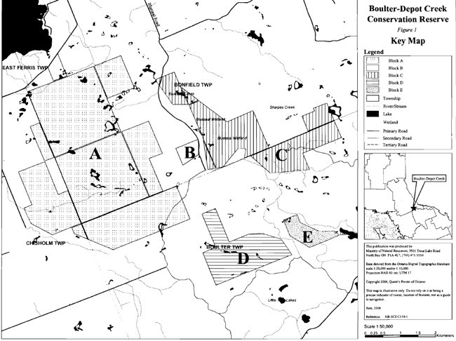
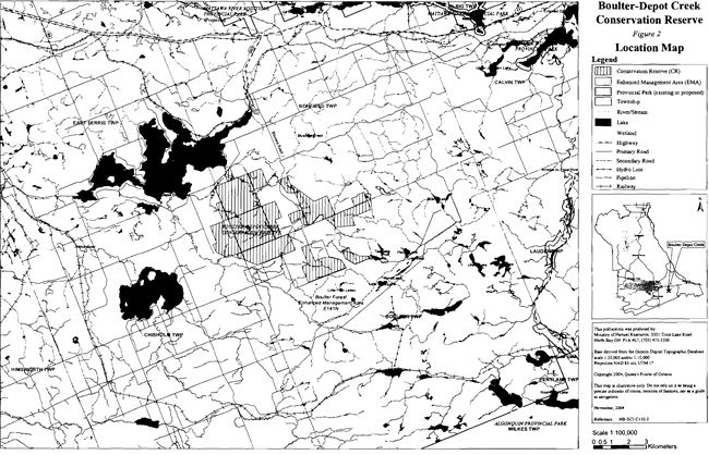
Boulter-Depot Creek Conservation Reserve is located in Ecodistrict 5E-5 approximately 25 km southeast of the City of North Bay (Figure 1). The boundary of the conservation reserve is located in the geographic townships of Bonfield, Boulter and Chisholm within the municipal Townships of Bonfield and Chisholm in the District of Nipissing (Figure 2). The conservation reserve is known to encompass significant earth science values. Two esker systems encompassing an array of esker ridges, kames, kettle holes and troughs are found in this site.
During the Lands for Life planning process the public was widely consulted and provided valuable input into what became Ontario’s Living Legacy. Boulter-Depot Creek Conservation Reserve was recommended for protection in Ontario’s Living Legacy Land Use Strategy which is now part of the Crown Land Use Policy Atlas. Consultation related to the formal regulation of the boundaries of this conservation reserve, through the Public Lands Act, also occurred.
Stakeholders who expressed an interest in the planning of this site were also notified regarding the draft SCI and given a one month review period. Any comments, including input from previous consultation, were considered in the finalization of this document. No new issues or concerns were expressed by the public during the review of this draft SCI. The draft was reviewed by MNR district specialists located on area teams who are responsible for the management of particular areas within the district, which include this conservation reserve.
This basic SCI provides guidance for the management of the conservation reserve and the basis of the ongoing monitoring of activities. More detailed direction is not anticipated at this time. Should significant facility development be considered or complex issues arise requiring additional studies, more defined management direction or special protection measures, a more detailed Resource Management Plan will be prepared with full public consultation.
Boulter-Depot Creek Conservation Reserve is managed under the direction of the District Manager and the Nipissing Area Supervisor, North Bay District, Ministry of Natural Resources.
Prepared by:
Klara Vodicka
District Planning Intern
John Thompson
NER
Rick Calhoun
District Planner
Signed by:
Dave Payne
District Manager
North Bay District
Date: October 23, 2006
Signed by:
Rob Galloway
Regional Director
Northeast Region
Date: October 31, 2006
1.0 Introduction
The purpose of this Statement of Conservation Interest (SCI) is to identify and describe the values of Boulter-Depot Creek Conservation Reserve. The SCI also outlines the activities that occur within the conservation reserve and provides guidelines for the management of current and future activities in the context of protecting the natural, social and cultural values of the conservation reserve. A SCI is prepared in accordance with MNR's policy for conservation reserves (Procedural Guideline A - Resource Management Planning, PL. Procedure 3.03.05).
Boulter-Depot Creek Conservation Reserve is a 2,348 hectare parcel of Crown land located 30 km southeast of the City of North Bay near Lake Nosbonsing. The boundary of the conservation reserve is located in the geographic townships of Bonfield, Boulter and Chisholm (figure 2). The site contains a variety of glacial landforms including esker ridges, kames, kettle holes and troughs of significant size and form. As a consequence of the geomorphology of the area, a variety of life science features are present including wetlands and forests of maple, birch, fir, aspen and pine. The site is a known hub of recreational activity for hunting, snowmobiling and All Terrain Vehicle (ATV) use.
Conservation reserves are established by regulation under the Public Lands Act. Boulter-Depot Creek Conservation Reserve was established by Ontario Regulation 208/03, under authority of the Public Lands Act (O. Reg. 805/94) on February 14, 2003. The planning area for this SCI is the regulated boundary of the conservation reserve.
2.0 Goals and Objectives
2.1 Goals
The goal of the Boulter-Depot Creek Conservation Reserve SCI is to identify and describe the natural and cultural heritage values within the conservation reserve while permitting compatible land use activities.
2.2 Objectives
The following objectives are identified as a means to achieve the above-stated goal.
- To describe the state of the resource with respect to natural heritage values and current land use activities.
- To manage the conservation reserve to protect the integrity of its natural values via specific guidelines, strategies and prescriptions.
- To meet planning requirements by addressing the management intent of the conservation reserve and addressing planning and management needs.
- To create a public awareness of the values within the conservation reserve and promote responsible stewardship of the protected area through partnerships with local stakeholders.
- To determine long-term management goals of the conservation reserve by identifying research, client services and marketing strategies.
- To identify scientific values on the site in relation to provincial benchmarks and identify the necessary monitoring and/or research to maintain the integrity of those values.
- To provide direction to evaluate new uses or economic ventures through the application of a Test of Compatibility (Procedural Guideline B) - Land Uses - PL. 3.03.05) (Appendix 1) and Ministry of Natural Resources (MNR) Class Environmental Assessment for Provincial Parks and Conservation Reserves.
3.0 Management Planning
3.1 Planning Context
3.1.1 Planning Area
The planning area for this SCI is the regulatory boundary of the conservation reserve. As noted earlier, MNR encourages the consideration of conservation reserve values in land use and resource management activities on the surrounding landscape. Any strategies noted within this plan related to and beyond the conservation reserve boundary, will be presented for consideration within a larger management planning context such as a forest management plan (FMP).
3.1.2 Management Planning Context
Ontario’s Living Legacy Land Use Strategy was approved in 1999 and provides the direction for the management planning of protected areas within the OLL planning area. The objectives of the Land Use Strategy are to complete Ontario’s system of protected areas; recognize the land use needs of resource based tourism industry; provide forestry, mining and resource industries with greater certainty around land and resource use; and enhance hunting, angling and other Crown land recreational opportunities. Boulter-Depot Creek Conservation Reserve was created as part of the expansion of protected areas.
Conservation reserves protect natural heritage values on public lands, while permitting compatible land use activities. By allocating these lands to the parks and protected areas system through regulation, the province has ensured a certain level of permanence by distinguishing the conservation reserve and its values from the larger general use or more extensively managed landscape. In addition, the conservation reserve’s natural features are, and will be available for present and future generations to enjoy and explore.
The Land Use Strategy (1999) and the Crown Land Use Policy Atlas outlines the general land use policy and management direction for new conservation reserves. Each new conservation reserve will have a planning document, either a SCI or, in more complex situations, a Resource Management Plan, that details site-specific management direction.
Comments received during the Lands for Life process, and during boundary consultation related to the formal regulation of the site were considered in the preparation of this document.
3.2 Planning Process
Once a conservation reserve is regulated, there is a need to determine the level of management planning required to protect values as well as ensure commitments to compatible uses are met. The SCI is a stewardship document that provides background information, identifies values to be protected and establishes management guidelines for the conservation reserve. The SCI was selected since there were no new issues beyond those addressed during land use planning for Ontario’s Living Legacy or during consultation prior to site regulation.
The implementation of policy will be the responsibility of the MNR at the district level. Associations with various partners may also be sought to assist in the delivery of the management program for the conservation reserve. It should be noted that the SCI is a working document and it will be necessary to make revisions to it from time to time. Although more detailed direction is not anticipated at this time, should significant additional or complex issues arise that may require additional studies, such as a more defined management direction or special protection measures, this SCI will be updated through a standard process of minor or major amendment or a more detailed Resource Management Plan will be prepared with full public consultation. Finally, periodic review of the document will occur.
4.0 Background Information
4.1 General Administrative Information and Site Description
4.1.1 General Administrative Information
The following chart summarizes administrative information for Boulter-Depot Creek Conservation Reserve:
| Name and OLL ID Number | Boulter-Depot Creek Conservation Reserve (C150) |
|---|---|
| Ecoregion/Ecodistrict (Hills, 1959; Crins, 2000) | 5E (Georgian Bay) 5E-5 (North Bay) |
| OMNR Administrative Region/District/Area | Northeast Region/North Bay District/ Wasi Area |
| Total Area (ha.) | 2,348 |
| Regulation Date | February 14, 2003 (O. Reg. 208/03) |
| Township(s) | Geographic Township of Bonfield, Township of Bonfield Geographic Township of Boulter, Township of Boulter Geographic Township of Chisholm, Township of Chisholm, District of Nipissing |
| First Nations | Antoine First Nation - area of interest Mattawa North Bay Algonquins - area of interest Nipissing First Nation - area of interest - through the Robinson Huron Treaty |
| OBM map sheets | 2017 6400 51100 |
| Topographic Map Name/Number | Powassan 31 L/3 |
| UTM coordinates | 645,000 m E 5,115,000 m N |
| General Location, Description, Access | Approximately 25 km southeast of North Bay. Site contains significant earth science and life science features including moraine and esker formations. There are numerous access points and trails into the conservation reserve. |
4.1.2 Site Description
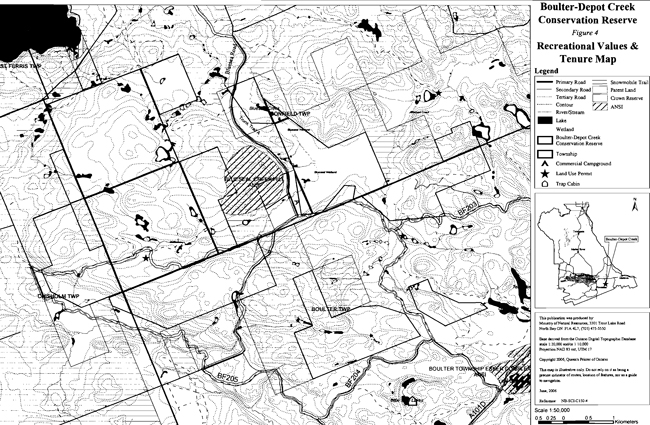
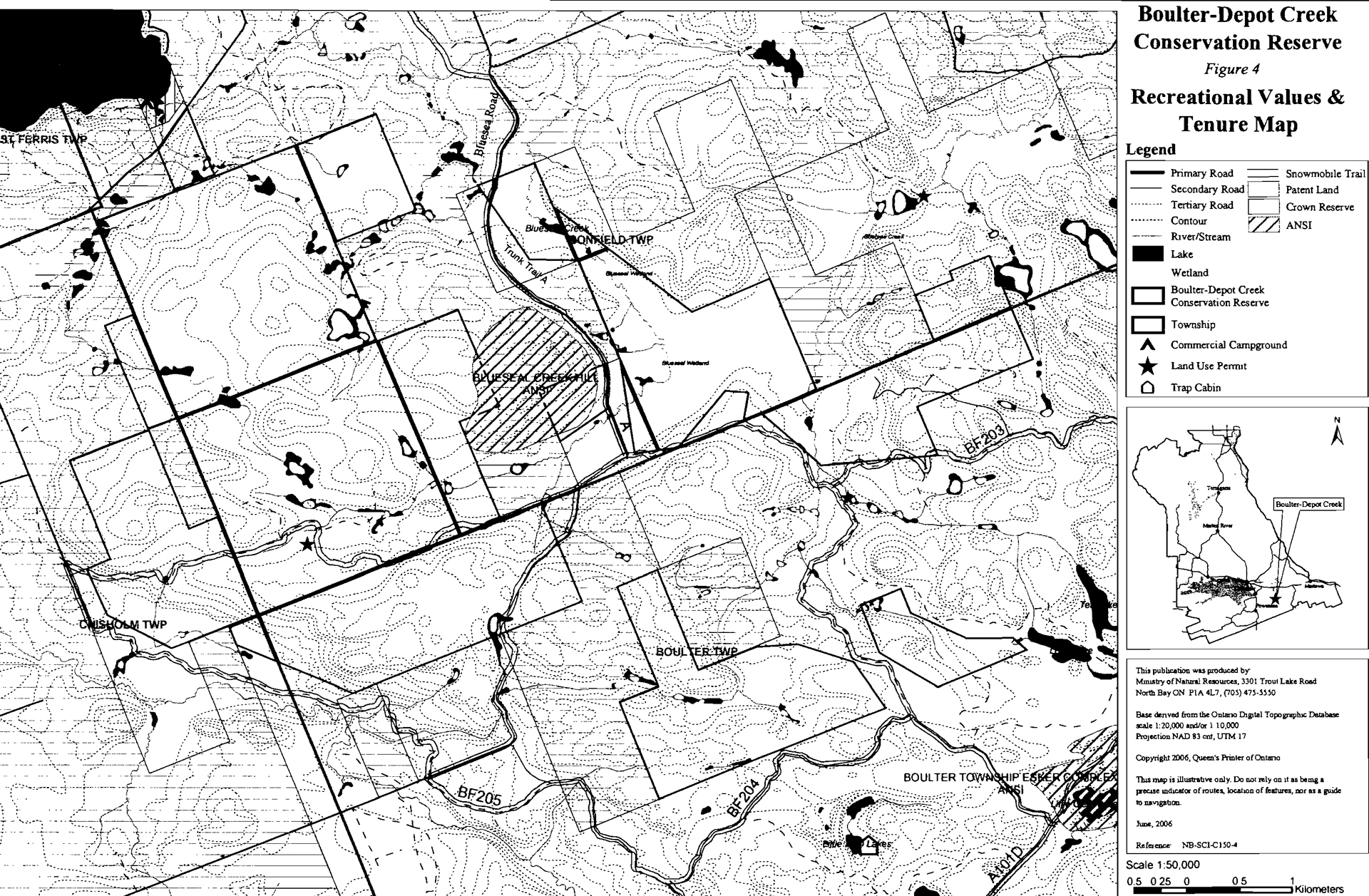
Boulter-Depot Creek Conservation Reserve is located southeast of Lake Nosbonsing, south of the Town of Bonfield, approximately 25 km from North Bay. The site is located within Ecodistrict 5E-5 (Crins, 2000; Hills, 1959). The conservation reserve is bordered by both patent and Crown land. This 2,348 hectare area was protected in order to preserve life science features associated with the site. The conservation reserve is a disjointed site made up of five individual blocks (figure 1). The conservation reserve can be accessed by secondary roads from both Highway 17 and Highway 11. Bluesea Road, south of Bonfield, is the easiest way to access the site. This road/snowmobile trail passes directly through Block C and forms the boundary of Block B (figure 4). Numerous trails can be found throughout the conservation reserve. Boulter Forest Enhanced Management Area (E141n) is located south of the conservation reserve.
4.2 Inventory and Survey Work
The following table provides an overview of inventories completed, their level of detail, and any further inventories that are required.
| Survey Level | Life Science | Earth Science | Cultural | Recreational |
|---|---|---|---|---|
| Reconnaissance | Burkhardt, et a/. 2004, Life Science Checksheet, Aerial Survey | Kristjansson I F.J.,2004, Earth Science Checksheet, Aerial Survey(in progress) | First Nations Interviews, 1998 & 2003, Native Background Information Report and Values Maps, related to Forest Management Planning | Sheppard, C., 2003, Recreational Inventory Checklist, Ground Survey |
| Detailed | None | None | None | None |
| Requirement | None | None | None | Monitor on an on-going basis |
5.0 State of the Resource
The conservation reserve is located entirely within Ecodistrict 5E-5 (Grins, 2000). Values include life science, earth science, cultural and recreational/aesthetic features with an emphasis on the life sciences.
The following provides a summary of the life science, earth science and cultural heritage values, as well as recreational opportunities.
Life science representation:
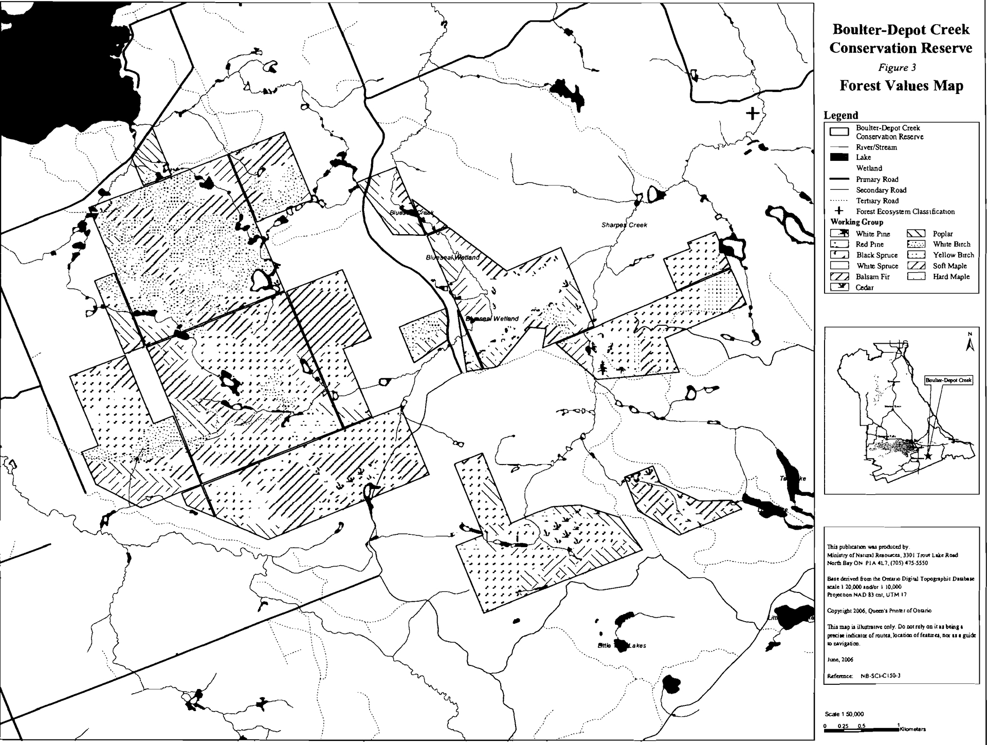
Due to the segmented nature of the conservation reserve and abundance of forest communities, the site has been split into 5 main blocks (figure 1). There are 41 forest communities and 3 wetland types lying on a combination of mostly bedrock, glaciofluvial ice-contact deposits and organic deposits.
The following landform types and vegetation associations and other features are found (Burkhardt et al., 2004):
- Best representation of deciduous and coniferous (dense, mixed and sparse) forest on ice contact deposits in Ecodistrict 5E-5 (Burkhardt et al.,2004)
- Dominant forest communities include sugar maple dominant hardwoods (13.3%), open muskeg (11.3%) red maple dominant hardwoods (8.8%), white birch predominant hardwoods (8.5%) and sugar maple predominant hardwoods (6.8%)
- Maple, birch, poplar and pine forests found on hilltops, upper slopes and bedrock controlled topography
- Balsam fir, cedar, tamarack and black spruce found in lower valleys and/or wetlands
- Old growth hardwood forest, and some super canopy white pine, is found in every block of the conservation reserve
- Old growth accounts for half of forest in the conservation reserve
- In tertiary watershed 2JE of the Ottawa River major basin
- Encompasses headwaters that flow into Lake Nosbonsing, Blueseal Creek, Depot Creek and Sharpes Creek
- Gravel deposits and groundwater discharge areas (seeps) provide critical brook trout habitat
- Locally significant fish staging and/or spawning and migration habitat present
- Wetlands account for 12% of the total area of the conservation reserve, found in every Block except B
- Treed muskeg, open muskeg and brush/alder swamp
- Possible provincially significant wetland in Block C surrounding Blueseal Creek called Blueseal Wetland
- Moose aquatic feeding areas present in Blueseal Creek Wetland, possibly within the bounds of the conservation reserve
- Heron rookeries present near aquatic areas in Block A
- Excellent waterfowl habitat
- Diverse wildlife including moose, deer, bear, grouse, beaver and various other furbearing mammals
- Dense canopy provides excellent summer cover for deer and possibly moose
- Locally significant winter cover for wildlife
Earth science representation:
Boulter-Depot Creek Conservation Reserve is dominated by bedrock drift complex with a drift type of till and potentially stratified drift, glaciofluvial ice contact deposits, organic deposits and a small section of possible glaciofluvial outwash deposit (Burkhardt et al., 2004; Kristjansson, 2004). The site contains portions of several eskers, kettles, kames and knoll forms. These features provide insight into historical glacial lake levels. The earth science features of the conservation reserve are of local significance while the surrounding landscape may be of greater significance.
Cultural heritage values:
The conservation reserve is in the area of interest for the Nipissing First Nation, Antoine First Nation and Mattawa North Bay Algonquins. More in-depth research concerning cultural heritage values has not been completed to date.
Recreational opportunities:
The site offers many recreational opportunities due to the numerous trails that provide access the site. Hunting, snowmobiling and ATV use are the most prominent recreational activities within the conservation reserve (Sheppard, 2003).
5.1 Life and Earth Science Representation
Significance is determined on the basis of the following criteria: representation, diversity, condition, ecological considerations and special features (Crins and Kor, 1998).
5.1.1 Life Sciences
Boulter-Depot Creek conservation reserve contains significant life science values. This conservation reserve was originally identified through gap analysis and contains 41 different forest communities including mixed deciduous and coniferous forest with sections of old growth as well as 3 different wetlands communities found throughout the site along with a large portion of a potentially provincially significant wetland in Block C. The site provides ideal habitat for a wide variety of wildlife including species such as: beaver, and great blue herons and rough-legged hawks (Burkhardt et al., 2004). The presence of many hunting stands, animal bones and scat in the conservation reserve suggests deer, moose and bear are abundant in the area (Sheppard, 2003; Vodicka and Todd, 2004). The area also supports traplines and bear management areas. The dense canopy would provide excellent summer cover for a variety of species.
5.1.2 Life Sciences Representation
Boulter-Depot Creek Conservation Reserve is comprised of mixed deciduous and coniferous forest interspersed with wetlands (figure 3). There are 41 forest communities and three wetland types within Boulter-Depot Creek Conservation Reserve. Approximately half of those 41 forest communities make up less than 1% of the total area. The dominant forest communities include sugar maple hardwoods which make up 13.3% of site, red maple dominant hardwoods that make up 8.8% of the site, white birch predominant hardwoods which make up 8.5% of the site and sugar maple dominant hardwood which makes up 6.8%. Wetlands account for 12% of the landscape within the conservation reserve (Burkhardt et al., 2004).
Another method of representation for forest communities used during the life science inventory of the site is through the use of habitat units. There are 14 habitat units within the conservation reserve four (4) of which account for less than 1% of the total area. The four (4) main habitat units consist of 23.9% of rich upland mix understory, 17.6% of mixed hardwood, 11.2% of hardwood selection forest and 10.3% of rich upland mixed closed canopy. All of the habitat units contain immature, mature and old growth forest as well as barren rocklands devoid of forest. Old growth can be found in every block of the conservation reserve. Some areas include stands that have been aged at 150 years (Burkhardt et al., 2004).
Wetland communities account for approximately 12% of the area within the conservation reserve. These wetlands consist of open water marsh, cattail marsh, meadow marsh and thicket swamps. Some poor fen and float mats can also be found within the site. Beaver activity is known to have a strong influence throughout the site and is evident from the abundance of lodges and dams within the conservation reserve.
Due to the size and disjointed nature of the conservation reserve, the site has been split into five (5) blocks in order to better identify location of various features within the conservation reserve (figure 1).
The largest block, Block A, encompasses white birch hardwood and mixedwood communities, popular mixedwood, sugar maple and red maple hardwoods and mixedwoods in addition to sections of open muskeg surrounding many creeks and tributaries. The block contains numerous wetland areas and provides a home to several heron rookeries.
The smallest block, Block B, contains predominately white birch and popular hardwoods. The old growth forest is sparse in this area and is only present towards the southern boundary of the block. This block is the only area that does not contain any wetland vegetation. The site includes part of Blueseal Creek Hill (figure 4) geologic feature which reflects a complex history of multiple glacial and post glacial events related to the flooding and drainage of Lake Algonquin and post Lake Algonquin stages.
Block C includes a large section of open muskeg that surrounds Blueseal Creek (Photo 1). This wetland contains open water marsh, open bog to semi-treed to treed bog with some treed fen along the northwestern section. One meter thick red and green sphagnum moss along with various other species such as cottongrass, sheep laurel, leatherleaf, Labrador tea and bog bilberry. A significant portion of this wetland is part of Blueseal Wetland which was evaluated using the Northern Ontario Wetland Evaluation System (Meil et al., 1998). With further research this wetland has a definitive potential to obtain provincial significance status. This wetland is of particular interest because of the palustrine nature of the site and the large number of cold water seeps which aid in the maintenance of high water quality and provide headwater recharge. The wetland provides valuable flood attenuation to areas downstream. Lowland areas surrounding the portion of the wetland in Block C are bound by species of black spruce, balsam fir and white cedar with some sections of red maple and poplar. The upland areas of this Block contain supercanopy white pine with a spruce and maple understory. Block C was found to have the greatest diversity of age groups in terms of forest communities. Waterfowl, ungulate and fish habitat are in good supply within the wetland area (Meil et al., 1998).
Block D contains small sections of wetland surrounding the lower portion of Sharpes Creek. The rest of this block consists of sugar maple hardwoods, cedar, poplar, balsam fir, white spruce and red pine.
Block E contains open muskeg surrounding the creek. Beyond that there are species of cedar, red maple hardwood and mixedwood along with poplar hardwoods (Burkhardt et al., 2004). Some tamarack is also present within the block.
There is abundant habitat diversity and hence wildlife diversity within the site. All of the blocks described above have a variety of wildlife that live within and surround the conservation reserve. The area is well known for deer, moose, bear, grouse and waterfowl hunting. Black duck, a species of special interest, moose and deer have been spotted within or adjacent to the site (Meil et al., 1998). The cedar forests provide a source of nutrition for deer and moose in the winter months while the mix of deciduous and coniferous species provides excellent summer habitat. Moose wintering and aquatic feeding areas are present, potentially within, and definitely surrounding the conservation reserve (OMNR, 2003). Various bird species were also identified within and surrounding the conservation reserve, these included, herons, rough-legged hawks, Lecomptes Sparrow, upland sandpipers, sedge wren and the black-billed cuckoo(Burkhardt et al., 2004; Romaniuk, 2004). The combination of wetlands and supercanopy white pine make the area ideal for osprey and heron (OMNR, 2001).
5.1.3 Earth Science Representation
Boulter-Depot Creek Conservation Reserve and the surrounding landscape contains significant earth science features. The site forms part of the larger glaciofluvial interlobate system that can be distinguished from the Lake Simcoe area in Southern Ontario to the Harricana Lake area in northwestern Quebec. The site contains features such as the junction of two esker systems which consist of an array of esker ridges, kames, kettle holes and troughs.
Block A contains bedrock terrain, bedrock drift complex, glaciolacustrine deposits and organic deposits. The drift cover is predominately till however there may be some areas of stratified drift in the lowlands and kame ice contact deposits on the flanks of the upland areas. The extreme northwest corner of the Block A may include a portion of an esker as well as the southern section of the Block. This esker then extends down into the surrounding enhanced management area Boulter Forest (E141n). There are also major sections of bedrock exposure in the southern portion of Block A. The mid western section of the site may include a small portion of a provincially significant glacial lake beach deposit that was formed during glacial advances and retreats. This beach deposit provides historical information on glacial lake levels that are associated with interlobate drainage and recessional ice margin positions of the Sobie-Guillemette outlet phase, drainage of post Algonquin Lake Payette and faint evidence of the shorelines of prehistoric Lake Shequindah. Much of this variation is visible through differing depths of sand and gravel deposits.
Portions of the Blueseal Creek Hill earth science feature, also an ANSI, extend onto private land and may be present within Block B of the conservation reserve. A bedrock knoll provides context to the depositional environment of a kame. A complex history of multiple glacial and postglacial events related to the inundation and drainage of glacial Lake Algonquin and its subsequent post Algonquin stages. The kame deposit and associated beach and bluff features are good examples of the relationship between ice-laid deposits which have been modified by post-Algonquin water levels. This feature is considered to be of provincial possibly national significance. The steep slopes and coarse granular nature of the kame deposit may be susceptible to erosion if natural vegetation cover is disturbed or removed. Portions of this property have been cleared or logged in the past (OMNR, 2004). The remaining area of the Block consists of glaciofluvial ice contact deposits and bedrock-drift complex.
Block C contains bedrock-drift complex with drift cover that is predominately till. Areas of ice-contact stratified drift deposits with landforms such as kames are present on the flanks of upland areas in the lowlands. Low lying areas, which make up the majority of the Block, contain glaciolacustrine deposits of what appears to be silt or clay and organic deposits in wet low lying areas. Blueseal Creek and the surrounding wetland form part of what may be a provincially significant wetland.
Block D contains ice-contact stratified drift deposits, bedrock-drift complex and organic deposits while Block E contains mostly bedrock-drift complex and organic deposits.
An enhanced management area (EMA), called Boulter Forest (E141n) also surrounds that site and is part of the glaciofluvial interlobate moraine system.
5.2 Quality of Representation
The quality of the representation or the current characteristics of the natural features found within a conservation reserve are as important as the overall representative features that are being protected. A number of factors are considered in evaluating the quality of a conservation reserve’s representative features. They include diversity, condition, ecological factors, special features and current land use activities.
5.2.1 Diversity
Diversity is a measure of the conservation reserve’s earth and life science variety. The evaluation is based on the number and range (assortment) of landscape features and landforms for earth science values and the relative richness and evenness of the site’s life science components.
Boulter-Depot Creek Conservation Reserve is considered to have a medium life science diversity rating with a moderately skewed evenness rating (Burkhardt et al., 2004) . There are 30 different landform: vegetation combinations however a portion of these account for less than 1% of the total area, thus contributing little to the site’s overall diversity rating. However, the presence of different communities and different developmental stages adds to the diversity of the site. A mixture of immature trees, mature forest and old growth forest including supercanopy pine make up a large portion of diversity within the site. Additional diversity can be accounted for by the presence of various wetland types which further enhances the diversity already present within the conservation reserve (Burkhardt et al., 2004).
Earth science diversity is considered low for the site is dominated by the bedrock drift and bedrock outcrop areas with some isolated organic and ice-contact landforms found within the site. When more varied landforms do exist they are often placed at the site’s margins or associated with drainage and wetlands (Block B).
5.2.2 Condition
Condition refers to the amount of human, and natural disturbance within a site. The conservation reserve has been rated to have a high level of disturbance due mostly to natural processes. White birch defoliation, possibly due to white birch skeletonizer occurred in most of the north half of Block A, most of Block B and portions of the other blocks depending on the distribution of white birch. Other natural disturbances include beaver dams which have altered creek flow and created new wetlands.
Human disturbance is also present, with the majority occurring in Block A. An ATV/Snowmobile trail cuts through the southern half of Block A, while other small segments of trail/road enter into different sections of Block C. Many additional trails can be found just outside or along the conservation reserve boundaries.
Logging has occurred in and around this site in the past. The current age distribution ranges 'from zero to 150 years. A large portion of the site is between 60 and 89 years old and 90 to 119 years old (Burkhardt et al., 2004) suggesting that logging may have taken place at a time just prior to the time frame of those growth periods. More recent logging is known to have occurred in the northeast corner of Block A, now regenerating with maple and aspen.
Numerous hunt stands (Photo 2) located at the end of foot and/or ATV trails can be found along the creeks in Block A. These activities in combination with the large amount of natural disturbance have had a significant impact on the life science values in the site.
5.2.3 Ecological considerations
Boulter-Depot Creek Conservation Reserve is a large yet relatively disjointed site. This 2,348 hectare site is comprised of 5 separate blocks of Crown land. These highly vectored blocks follow adjacent property line boundaries and in few small sections local roads. The site is not bounded by natural features and thus, is not ecologically self-contained. Block A is the only area that is large enough to allow for the protection of core ecosystem values (Burkhardt et al., 2004). Block C is also quite large in comparison to Blocks B, D and E. However, Block C is very disjointed and contains very long and narrow segments. Only the bog complex, within the widest section of Block C, will have core ecosystem values protected. Blocks B, D and E provide limited protection for earth and life science values. Overall many of the earth and life science features within the site are not ecologically self contained. The site has the capacity to support various recreational activities however some of these activities may be difficult to pursue on the ground due to the unmarked vectored boundaries of the site. Currently the conservation reserve is mainly used for hunting, snowmobiling and ATV use.
5.2.4 Special Features
Boulter-Depot Creek Conservation Reserve contains many core natural heritage features. The conservation reserve was put forward for protection because of life science values. The site forms part of the interlobate moraine system that extends from the Lake Simcoe area in Southern Ontario to the Hurricana Lake area in Quebec. Esker and kame deposits on bedrock drift complex form part of this system and are of local significance. A glacial lake beach deposit near and possibly partially included within the site, is of regional significance and may be of provincial significance (Kristjansson, 2004).
The conservation reserve was also found to contain the best representation of deciduous and coniferous (dense, mixed and sparse) forest on ice contact deposits in Ecodistrict 5E-5. When comparing the landform:vegetation summary provided by Ontario Parks and using Kristjansson’s interpretation, the conservation reserve may be considered provincially significant (Burkhardt et al., 2004). Old growth hardwood forest, interspersed with supercanopy white pine, accounts for approximately half of the conservation reserve. In addition to these representative features part of Blueseal Creek Wetland, a possible provincially significant wetland, is included within Boulter-Depot Creek Conservation Reserve. However, further research and analysis is required in order to accurately classify its significance. Numerous other small wetlands can also be found throughout the site. Portions of these wetlands provide suitable waterfowl breeding and moulting habitat and locally significant fish staging and/or migration habitat. Several seeps are also present within or near this area.
The conservation reserve serves as a hub for wildlife. There is excellent summer and winter cover for ungulates. The super canopy white pine provides potential refuge trees and bedding sites for black bears (OMNR, 2001). The crowns of super canopy pine offer ideal potential nesting and perch sites for species such as bald eagles and osprey. Certain species of woodpeckers, songbirds, hawks and owls prefer older growth forests to younger forests. Insects including dragonflies and beetles are known to appear more frequently and in greater variety in old growth forests. As the old growth vegetation dies and decays these trees continue to add diversity to the site (OMNR, 2001).
5.3 Cultural Values
There are no archeological sites identified within the conservation reserve. There are areas of high potential cultural heritage. High potential cultural heritage areas are identified using a computer based predictive modeling program. Based on a series of pre-defined parameters, the program identifies candidate areas, which are most likely to be culturally significant. The conservation reserve is within the area of interest of the Nipissing First Nation, Antoine First Nation and Mattawa North Bay Algonquins.
5.4 Recreational/Aesthetic Values
Recreational activities such as hunting, snowmobiling, ATV use, aquatic wildlife viewing and general nature study take place within Boulter-Depot Creek Conservation Reserve. The conservation reserve is known for its hunting appeal due to the many waterfowl, deer, moose, bear and grouse that inhabit and use the area. Opportunities for aquatic wildlife viewing and general nature study including activities such as birdwatching exist within the site because of the abundance of wetlands. Local residents as well as tourist operators and their clients frequent the conservation reserve.
A land use permit exists in the southwestern portion of the conservation reserve. This permit is for a private recreation camp. A second private recreation camp is located near the southeastern border of the site, however outside of the conservation reserve. There are numerous trails surrounding the conservation reserve many of which are utilized as snowmobile trails in the winter (Photo 3). These trails may also serve as ATV or hiking trails in the summer months. Portions of these trails enter into the bounds of the conservation reserve, specifically in Block A, Block C and along the border of Block B (figure 2 & 4). The site may be easily accessed from all sides by these already established trails. The location of the conservation reserve makes all of these activities even more appealing due to its close proximity to the City of North Bay, the Town of Mattawa and the Hamlet of Bonfield.
5.5 Heritage Estate Contributions
The conservation reserve was identified as possessing significant life science values through gap analysis during the Lands for Life planning process. The most significant features within the site include:
- Junction of two esker systems which consist of an array of esker ridges, kames, kettle holes and troughs which are provincially significant for their exceptional size and form
- Enhanced management area Boulter Forest (E141n), containing provincially significant glacial lake beach deposits is present south of the site
- Old growth hardwood forest ranging from 79-150 years of age
- Possible provincially significant wetland in Block C known as Blueseal Creek Wetland (requires further research and confirmation)
- Excellent summer and winter cover for deer and moose
- Portions of the wetland provide suitable waterfowl breeding and moulting habitat
- Locally significant fish habitat, a fish staging and/or migration habitat is present
- Gravel deposits and groundwater discharge areas (seeps) provide critical brook trout habitat
Additional values and features not described here can be found on page 6 and 7. Should a new, significant key value be identified, current management guidelines may be modified to ensure its protection.
The protection provided through designation as a conservation reserve, will help to ensure the preservation of the site for future generations. Boulter-Depot Creek Conservation Reserve will maintain many of the unique earth and life science values associated with the site and be protected from commercial and industrial use, while allowing already existing recreational opportunities to continue.
6.0 Management Guidelines
6.1 Management Planning Strategies
The land use intent outlined in Ontario’s Living Legacy Land Use Strategy provides context and direction to land use, resource management, and operational planning activities on Crown land. Commitments identified in the above strategy and current direction (PL Procedure 3.03.05) will form the basis for land use within Boulter-Depot Creek Conservation Reserve. For up-to-date information on permitted uses refer to the Crown Land Use Atlas at /page/crown-land-use-policy-atlas/.
Existing permitted uses within the conservation reserve may continue, unless they are shown to have a significant negative impact on the values within the site.
Proposed uses and development within the conservation reserve will be reviewed on a case-by-case basis. A Test of Compatibility (Appendix 1) must be passed before they are deemed acceptable. The emphasis will be on ensuring that the natural values of the conservation reserve are not negatively affected by current or future land use activities. Therefore, any application for new specific uses will be carefully studied and reviewed. The Ministry, partner organizations and/or proponents may undertake such studies. Requirements under MNR's Class Environmental Assessment for Provincial Parks and Conservation Reserves (2004) will also be met.
6.2 Land Tenure
Background:
Boulter-Depot Creek Conservation Reserve consists entirely of Crown lands. All sections of the conservation reserve except section E are surrounded by both patent and Crown land. Section D is surrounded solely by Crown land (figure 3).
There is one land use permit located in the southwestern portion of Block A. This permit authorizes a private recreation camp. Several other land use permits are located in the vicinity of the conservation reserve, including two private recreation camps. One private recreation camp is located near the southern boundary of Block C.
There are several snowmobile trails and tertiary roads located in and around the conservation reserve. These trails cross through Block A and Block C of the conservation reserve. In addition one trail/road forms the boundary of Block B.
Guideline:
The sale of Crown lands within the conservation reserve is not permitted.
New recreation camps are not permitted, however existing recreation camps will be permitted to continue. Existing camps may be eligible for "enhanced" tenure, but are not eligible for purchase of land. There are two forms of enhanced tenure that may be considered:
- Upgrade in the nature or type of tenure (e.g. from Land Use Permit to a lease); and/or
- An extension in terms of the tenure (e.g. from 1 year to 10 years)
Application for enhanced tenure will be approved if determined acceptable using a screening criteria. A change in tenure does not convey a commitment to provide for, or agree to, a change in the type or the standard of existing access to the recreation camp.
Unauthorized occupations of lands within the conservation reserve will be handled in accordance with approved policy, and any required structural removal will be at the owner’s expense.
6.3 Development and Access
Background:
There is limited development within the conservation reserve which presently includes only duck blinds, bear stands and a private recreation camp authorized by land use permit in Block A of the conservation reserve. Besides these, there are no other buildings, facilities or utilities within the conservation reserve (figure 3).
The site can be accessed by various roads and trails surrounding the conservation reserve. Ontario Federation of Snowmobile Clubs (OFSC) club trails, including BF 205, pass through the southern portions of Block A. OFSC Trunk Trail A runs along the boundary of Block B, through the northern portion of Block C and between Blocks D and E. This trail serves as both an ATV trail as well as a rugged tertiary road in the summer. The northern section of this trail, which, also serves as the boundary of Block B is called Bluesea Road. It is the most obvious access to the conservation reserve, however access is often difficult. During the spring, fall and even summer months a section of the road/trail is often flooded by the adjacent wetlands (Photo 4). ATV access is possible, however, in areas of deeper water ATV users often traverse along the edges of the road/trail and compact the adjacent wetland vegetation. An additional club trail, possibly BF 203, along with an existing trail crosses over into the southern section of Block C. Other trails not specific to snowmobile or ATV use include a trail that crosses the northern portion of Block A as well as a trail that crosses Block B leading to a cottage located on private property and then continues to an existing hunt stand (figure 3). Footpaths and trails leading to various bear stands and duck blinds can be found throughout the site and are not documented through mapping.
Guideline:
New roads for resource extraction and/or private use will not be permitted, nor will additions to existing roads or upgrading of existing private roads.
New trails are not encouraged, however they may be considered when compatible with other recreational uses and the maintenance of environmental integrity. Any new trail development must go through a Test of Compatibility to ensure the quality of the life and earth science representation and any additional values (e.g. aesthetics, landscape views, sensitive areas) are maintained.
Use of existing authorized snowmobile trails will be permitted to continue as long as they not impair the natural features and values for which the area was identified and there are no significant environmental impacts. Consideration for new snowmobile trails will occur on a case-by-case basis, but will not be encouraged. Public consultation will be an important part of the process.
In the case of ATV's, the demand, as well as the environmental impact of this activity, will be determined before specific trails are designated or constructed. In general, new ATV trails will be discouraged. Existing trails that enter sensitive wetland areas should be monitored and restricted if deemed necessary.
The use of existing unauthorized trails will be monitored to ensure that conservation reserve values are not being adversely impacted. Depending on the results of the monitoring, some of the unauthorized trails may need to be redirected from sensitive areas or eliminated completely. This includes unmarked footpaths and trails leading to bear stands and duck blinds found throughout the site.
The district may at sometime in the future consider developing a trails strategy to ensure the values within the conservation reserve are fully protected while maintaining current permitted uses to occur. Access to resources will include both direct access (e.g. current roads or trails) and/or more remote access (e.g. waterways) opportunities. Such planning could include public consultation.
Facility infrastructure and development for recreation may be considered in future if there is a demonstrated need for such facilities and Test of Compatibility is completed. A more detailed management plan would be required prior to construction.
6.4 Recreational Activities
Background:
Existing recreational uses include waterfowl, upland bird, small and large mammal hunting, snowmobiling, ATV use, viewing of aquatic wildlife and general nature study.
Guideline:
Most recreational activities that have traditionally been enjoyed in this area can continue provided they pose no threat to the natural ecosystems and features protected by the conservation reserve.
Mechanized travel is permitted only on existing trails. Off-trail mechanized travel is permitted for retrieval of game only.
New recreational activities will be considered on a case-by-case basis. Emphasis will be placed on activities that have a low environmental impact on the conservation reserve. MNR will perform a Test of Compatibility to ensure that the natural heritage values are not negatively impacted by such potential recreational activities.
6.5 Industrial Activities
Background:
Boulter-Depot Creek Conservation Reserve is located within the Nipissing Forest but has been removed from the licensed area. An examination of the possible impact of activities on adjacent lands on natural heritage values should be considered in the Forest Management Plan.
There are no existing mining, timber harvesting, aggregate extraction or utility activities within the conservation reserve.
Mining and surface rights have been withdrawn from staking within the conservation reserve under the Mining Act (RSO Chapter M.14). There are no claims present within or near the conservation reserve.
Guidelines:
Conservation reserve regulations do not permit mining, commercial forest harvesting, hydroelectric power development, the extraction of aggregate and peat or other industrial uses (Public Lands Act. Ontario Regulation 805/94).
6.6 Commercial Activities
Background:
The conservation reserve has active baitfish licenses for Bonfield, Boulter and Chisholm Townships. The conservation reserve also includes portions of two trapping licenses, NB-64 and NB-55, and two bear management areas, NB-48-03 and NB-48-04. The Ministry of Natural Resources authorizes these activities.
Guideline:
Existing non-industrial commercial uses such as trapping and baitfish harvesting will be permitted to continue. These activities will continue to be monitored in order to ensure they do not deplete natural resources and that they impose a minimal impact on the features identified for protection. New trap cabins will not be permitted in the conservation reserve.
New non-industrial commercial activities (i.e. traplines) which overlap with the conservation reserve may be considered subject to a Test of Compatibility (Appendix 1), consistent with provincial direction. Any new trails associated with the new non-industrial commercial activities must also be considered subject to a Test of Compatibility.
Existing commercial bear hunting operations are permitted to continue but the introduction of new operations will not be allowed.
The issuance of Licenses to Provide Bear Hunting Services will be allowed where areas have been licensed or authorized under agreement for the activity since January 1, 1992 (there must be documentation in Ministry files that commercial bear hunting has been licensed during the period January 1, 1992 to present) unless:
- The Government has taken action to discontinue the activity; or
- Proceeding would create/aggravate resource sustainability issues (e.g., wildlife management reasons, imparts on values); or
- Licensing or permitting should be deferred due to Aboriginal issues.
Licenses to Provide Bear Hunting Services will not be issued in areas where issuance has not occurred since January 1, 1992.
6.7 Aboriginal lnterests
Background:
The conservation reserve is within the area of interest of Nipissing First Nation, Antoine First Nation and the Mattawa North Bay Algonquins. Areas of high potential cultural heritage have been identified within and surrounding the site.
Guideline:
All aboriginal and treaty rights will continue to be respected and are not affected by the establishment of this conservation reserve.
Any future proposals or decisions that have potential impact(s) on the individual or aboriginal or community values will involve additional consultation with the affected aboriginal groups.
6.8 Natural Resource Stewardship
Background:
Boulter-Depot Creek Conservation Reserve is a 2,348 hectare site with mixed deciduous and coniferous forest consisting of maple, birch, poplar, cedar, pine, balsam fir and spruce interspersed with wetlands. Preliminary analysis shows that approximately half of the forest that makes up the site is candidate old growth forest, which ranges from 79 to 150 years of age. Scattered super canopy white pine are present within the site and provide excellent wildlife habitat.
Boulter-Depot Creek Conservation Reserve is an important area for wildlife. The conservation reserve provides excellent habitat for deer, moose, bear, waterfowl, upland birds and furbearing mammals. Evidence of a variety of species is present throughout the conservation reserve. Bear and wolf scat were identified in addition to numerous ungulate bones (Vodicka and Todd, 2004; Sheppard, 2003). The super canopy white pine interspersed with cedar and various deciduous species provide both ideal summer and winter habitat for moose and deer.
A large portion of a possibly provincially significant wetland is present within the conservation reserve. However, further research and analysis will need to be conducted in order to confirm this possible designation. Wetlands play an important role in the surrounding landscape. They influence water quality, aid in flood control, provide spawning and nursery sites for fish and are home to variety of wildlife (OMNR, 2001). This wetland contains suitable habitat for waterfowl staging, breeding and moulting, locally significant fish staging and/or migration habitat as well as several seeps (Meil et al., 1998). Numerous moose aquatic feeding areas are present south of the conservation reserve and within Blueseal Wetland. A portion of Blueseal Wetland is present within Block C of the conservation reserve. This unique conservation reserve offers excellent nature study opportunities in addition to already existing recreational hunting prospects in a highly accessible site.
Guideline-Vegetation:
The conservation reserve will be managed by allowing natural ecosystems and processes to function as they would with minimal human interference.
The MNR recognizes fire as an essential process fundamental to the ecological integrity of conservation reserves. In accordance with existing Conservation Reserve Policy and the Forest Fire Management Strategy for Ontario, forest fire protection will be carried out as on surrounding lands unless otherwise directed through a Fire Management planning initiative that would include public consultation.
Whenever feasible, the MNR fire program will endeavour to use "light on the land" techniques, which do not unduly disturb the landscape, within this conservation reserve. Examples of light on the land techniques may include limiting the use of heavy equipment or limiting the number of trees felled during fire response efforts.
Opportunities for prescribed burning to achieve ecological or resource management objectives may be considered. These management objectives will be developed with public consultation prior to any prescribed burning, and reflected in the document that provides management direction for this conservation reserve. Plans for any prescribed burning will be developed in accordance with the MNR Prescribed Burn Policy, its associated planning manual and the Class Environmental Assessment for Provincial Parks and Conservation Reserves in cooperation with Fire Management staff.
Personal use permits for wood harvesting are not permitted.
The recreational human induced impacts on the forest community will be monitored and restricted in some areas (e.g. ecologically sensitive spawning areas, sensitive vegetation and wildlife areas) if deemed necessary. Activities such as ATV use should be monitored and restricted in some areas if ecologically sensitive wetlands are damaged and disturbed.
Programs may be developed to control forest insects and diseases in the conservation reserve where these threaten significant values in or adjacent to the site. Where insects or disease threaten significant values, in or adjacent to the site, control will be directed as narrowly as possible to the specific insect or disease. Biological control will be used whenever possible. Any future action shall have regard for the Test of Compatibility.
Guideline-Fish and Wildlife:
Sport hunting and sport fishing will be permitted within the conservation reserve. Fish and wildlife resources will continue to be managed in accordance with policies and regulations prevailing in the area and under the direction of the Wasi Area Supervisor. Provincial legislation and policy will dictate management and enforcement objectives for this area.
6.9 Cultural Resource Stewardship
Background:
There have been no specific studies or inventories undertaken by the MNR within the conservation reserve and no specific cultural resource values that have been evaluated or identified to date. However, areas of high potential heritage have been identified within the site.
Guideline:
When possible, the Ministry of Natural Resources will work with the Ministry of Culture and/or any First Nation community associated with these conservation reserve lands to identify any archeological/cultural sites to be protected.
6.10 Client Services
Background:
There are currently no client services associated with this conservation reserve.
Guideline:
The focus will remain on low key information and self-interpretation of conservation reserve features. Messages should focus on the area’s natural heritage features - their significance and/or sensitivity, recreation opportunities, nature appreciation and education.
Information regarding the Boulter-Depot Creek Conservation Reserve may be delivered from different sources; however, MNR will be the lead agency for responding to inquiries. A management agreement may be pursued with an appropriate partner to share responsibilities for information services and the delivery of other client services aspects of this SCI.
Consideration will be given to the strategic location of signs where roads or trails cross the conservation reserve boundary. There are no other plans for structural development within this conservation reserve.
6.11 Monitoring, Assessment and Research
Background:
Research and assessment to date has included a wetland evaluation, earth science, life science and recreation checksheets. Since recommendations were provided, these checksheets have been used in the assessment of this site. Further research is recommended with respect to Blueseal Wetland, a portion of which is located in Block C of the conservation reserve. At the present time, this wetland is considered to have a borderline provincially significant rating. With further investigation it is likely that this site will be considered provincially significant. Research may also be conducted to determine the extend of angling opportunities for brook trout in Blueseal Creek and Sharpes Creek.
Guideline:
Consideration will be given to inventory and documentation of natural and cultural values, and the assessment of use/activity impacts. All research will be carried out in a non-destructive manner. Research proposals must follow Procedural Guideline C - Research Activities in Conservation Reserves (PL 3.03.05).
The collection/removal of vegetation and parts thereof will not be permitted; however, subject to a Test of Compatibility (Appendix 1), the Area Supervisor may authorize the collection of plants and/or parts for purposes of rehabilitating degraded sites within the conservation reserve and collecting seeds for maintaining genetic stock and/or research. Additional conditions to approvals may apply.
Research, education and interpretation will be encouraged to provide a better understanding of the management and protection of the natural heritage values and will be fostered through local and regional natural heritage programs, initiatives and partnerships.
6.12 Marketing
Background:
There has been no marketing of this conservation reserve to date. Promotion and information about this site has been primarily through the Ontario’s Living Legacy planning process and public consultation regarding the boundaries of this site.
Guideline:
Marketing activities of this conservation reserve will be kept to a minimum.
7.0 Implementation
Implementation of the SCI and management of the conservation reserve are the responsibility of the Wasi Area Supervisor, North Bay District of the Ministry of Natural Resources.
Emphasis will be placed on awareness information highlighting conservation reserve values and appropriate uses.
Priorities will include:
- Maintaining the quality of earth and life science features such as the possible glacial lake deposits, eskers and Blueseal Wetland;
Appendix 1 - Procedural Guideline B - Land Uses - Test of Compatibility (PL Procedure 3.03.05)
The Conservation Reserve policy provides broad direction with regard to the permitted uses. The policy provides only an indication of the variety of uses that will be considered acceptable in conservation reserves. The only caution is that "any new uses, and commercial activities associated with them, will be considered on a case by case basis, and, they must pass a test of compatibility to be acceptable." What does a 'test of compatibility' mean? An examination of this must start from the premise of why an area is set aside specifically, its representative natural heritage values. Criteria are then identified to guide compatibility considerations. These criteria apply to the long-term acceptability of both existing uses and new uses.
-
Conformity to SCI/RMP: SCI describe values for which an area has been set aside and the range of appropriate uses that will be permitted in the area. SCI may also speak to the acceptability of other 'new' uses currently not occurring in the area.
The first 'test' is: "do proposed new land uses and/or commercial activities conform to the direction of the SCI/RMP for the conservation reserve? Would the new use(s) depart from the spirit of appropriate indicator land uses in the SCI/RMP?"
- Impact Assessment: If the proposed use(s) pass test 1 it is important to determine their impact on the area before they are approved. This should include the following:
- Impact on natural heritage values: "will the new use(s) impact any natural values in the area? If so how and to what degree? Is it tolerable?"
- Impact on cultural values: "will the new use(s) impact an historical or archaeological values in the area?"
- Impact on research activities: "will the new use(s) affect research activities in the area?"
- Impact on current uses: "will the new use(s) have any negative impact on the array of cu rrent uses?"
- Impact on area administration: "will the new use(s) increase administrative costs and/or complexity?" (For example, the cost of area monitoring, security and enforcement).
- Impact on accommodating the use outside the conservation reserve: "Could the use(s) be accommodated as well or better outside the conservation reserve?"
- Impact on socio-economics of the area: "will the new use(s) affect the community(ies) surrounding the area in a positive or negative way?" (For example, will the new use make an area less remote thereby affecting a local tourism industry that is dependent on the area’s remoteness for its appeal?"
- Impact on area accessibility: "does the new use(s) give someone exclusive rights to the area or a portion of the area to the exclusion of other existing uses?"
The following table provides a guide of indicator uses for the consideration of uses that may be permitted within conservation reserves. For any specific conservation reserve that test of compatibility should be applied to determine which specific uses are acceptable.
Appendix 2 - Public Lands Act Policy (3.03.05) Conservation Reserve Permitted Use Table
Indicator Uses for Conservation Reserves
Recreation
| Permitted Activities | Generic Existing (Yes, No Maybe) |
Generic New (Yes, No Maybe) |
(C150) Specific New Uses (Yes, No Maybe) |
|---|---|---|---|
| Sport hunting | Yes | Yes | Yes |
| Food gathering | Yes | Yes | Yes |
| Facility infrastructure | Maybe | Maybe | Maybe1 |
| Non-trail snowmobiling | Maybe1 | Maybe1 | Maybe2 |
| Non-trail ATV use | Maybe1 | Maybe1 | Maybe2 |
| Rock climbing/caving | Maybe | Maybe | N/A |
| Canoeing/kayaking | Yes | Yes | Yes |
| Motorized boating | Yes | Yes | Yes |
| Picnicking | Yes | Yes | Yes |
| Camping | Maybe | Maybe | Yes |
| Trails | Yes | Maybe | Maybe1 |
| Hiking | Yes | Maybe | Maybe1 |
| X country skiing | Yes | Maybe | Maybe1 |
| Cycling | Yes | Maybe | Maybe1 |
| Horse riding | Yes | Maybe | Maybe1 |
| Snowmobiling | Yes | Maybe | Maybe1 |
Maybe1= New uses will be considered on a case by case basis provided they do not impact the natural heritage calues for which the area was established, and must pass a test of compatibility to be acceptable.
Maybe2= For retrieval of game only.
Science, Education & Heritage Appreciation
| Permitted Activities | Generic Existing (Yes, No Maybe) |
Generic New (Yes, No Maybe) |
(C150) Specific New Uses (Yes, No Maybe) |
|---|---|---|---|
| Research | Yes | Yes | Yes |
| General walking | Yes | Yes | Yes |
| Photography and painting | Yes | Yes | Yes |
| Wildlife viewing | Yes | Yes | Yes |
| Outdoor education/interpretation | Yes | Yes | Yes |
|
Collecting |
No | No | No |
Commercial Activities
| Permitted Activities | Generic Existing (Yes, No Maybe) |
Generic New (Yes, No Maybe) |
(C150) Specific New Uses (Yes, No Maybe) |
|---|---|---|---|
| Food harvesting | Maybe | Maybe | No |
| Fishing | Maybe | Maybe | No |
| Baitfish harvesting | Yesl | Maybe | Yes |
| Trapping | Yesl | Maybe | Yes |
| Trap cabins | Yes | No | No |
| Resort-outpost camp | Yesl | No | No |
| Outfitting-bear management | Yesl | No | Yes |
| Wild rice harvesting | Yes | Maybe | No |
Yesl= Transfer requests will be considered in the context of a Statement of Conservation Interest (SCI) or Resource Management Plan (RMP) for each conservation reserve.
Resource Management
| Permitted Activities | Generic Existing (Yes, No Maybe) |
Generic New (Yes, No Maybe) |
(C150) Specific New Uses (Yes, No Maybe) |
|---|---|---|---|
| Inventory monitoring | Yes | Yes | Yes |
| Featured species management | Maybe | Maybe | Maybe |
| Natural systems management | Maybe | Maybe | Maybe |
Industrial Activities
| Permitted Activities | Generic Existing (Yes, No Maybe) |
Generic New (Yes, No Maybe) |
(C150) Specific New Uses (Yes, No Maybe) |
|---|---|---|---|
| Timber harvesting | No | No | No |
| Prospecting | No | No | No |
| Mining | No | No | No |
| Hydro generation | No | No | No |
| Energy transmission corridors | Yes | No | No |
| Communications corridors | Yes | No | No |
| Transport corridors | Yes | No | No |
| Resource roads (MNR) | Yes | No | No |
| Land disposition | * | No | No |
| Hunt camps | Yes1 | No | No |
*= Existing dispositions will continue, however, as opportunities arise the Ministry will acquire and/or remove them outside of the conservation reserve.
Yes1= Transfer requests will be considered in the context of a Statement of Conservation Interest (SCI) or Resource Management Plan (RMP) for each conservation reserve.
Appendix 3- Glossary of Terms
Biological Control: Control of pests by disrupting their ecological status, as through the use of organisms that are natural predators, parasites, or pathogens. Also called biocontrol2
Bog: Peat-covered areas or peat filled depressions with a high water table and a surface carpet of mosses, chiefly Sphagnum9
Clay: A sedimentary material with grains smaller than 0.002 millimeters in diameter2
Crown Land: Land owned by the provincial or federal government5
Cultural Heritage: Collective term describing examples of a society’s evolution (e.g. history, anthropology and archaeology) worthy of study and preservations5
Cultural Resources: Sites, features or artifacts related to the Province’s archaeology, anthropology or history, preserved in a natural settings5
Ecodistrict: An ecological landscape unit (ranging in resolution in hundreds of square kilometers) characterized by a distinct patterns in landform8
Ecoregion: An ecological landscape unit (ranging in resolution from hundreds of thousands to tens of thousands of square kilometers) characterized by distinct patterns of responses to climate as expressed by soils, hydrology, vegetation (species ranges and productivity), and fauna7
Ecosystem: An ecological community together with its environment, functioning as a unit2
Esker: A long, narrow ridge of coarse gravel deposited by a stream flowing in or under a decaying glacial ice sheet2
Fen: Peatland characterized by surface layers of poorly to moderately decomposed peat, often with a well-decomposed peat near the base9
Habitat Unit: Ecological grouping of similar forest tree species10
Hydrology: The science of water, its properties and laws, and its distribution over the earth’s surface9
Igneous Rock: Any of various crystalline or glassy rocks formed by the cooling and solidification of molten earth material1
lnterlobate Moraine: A moraine that formed between two adjacent lobes of glacial ice3
Kame: A short ridge or mound of sand and gravel deposited during the melting of glacial ice2
Kettle: A depression left in a mass of glacial drift, formed by the melting of an isolated block of glacial ice2
Knoll: A small rounded hill or mound; a hillock2
Lacustrine: Of or relating to lakes2
Moraine: A knobby ridge either of (a) boulder clay built or by a thrust of a glacier or of (b) gravel and sand deposited at the edge of glacier escaping meltwater4
Moulting: To shed or cast the hair, feathers, skin, horns, or the like, as an animal or a bird2
Northern Wetland Evaluation System: A rationale and protocol for assessing wetlands in northern Ontario in order to rate wetland function and determine its relative significance for a given area. The system considers the functional role wetlands play in maintaining critical ecosystem functions, providing social benefits, imwoving hydrological systems and water quality as well as protecting rare species9
OBM: Ontario Base Map, refers to a geographic division of Ontario according to lines of longitude into mapsheets based on the UTM map projection system6
Palustrine: The proportion of the wetland that either has absent or intermittent inflow and either intermittent or permanent outflow9
Patent: An exclusive right or title2
Peat: Partially carbonized vegetable matter, usually mosses, found in bogs and used as fertilizer and fuel2
pH: A measure of the acidity or alkalinity of a solution, numerically equal to 7 for neutral solutions, increasing with increasing alkalinity and decreasing with increasing acidity. The pH scale commonly in use ranges from zero to fourteen2
Provincially Significant Wetland: Lands that are important on a provincial scale that are seasonally or permanently flooded by shallow water as well as lands where the water table is close to the surface; in either case the presence of abundant water has caused the formation of hydric soils and has favored the dominance of either hydrophytic or water tolerant plants9
Silt: Mineral particles smaller than sand but greater than clay sizes4
Species of Special Status: Species that are the subject of unusual interest or unique concern. Applies specifically to wetland areas9
Staging Area: Any area where migratory birds congregate to eat and rest prior to continuing their journey9
Topography: Graphic representation of the surface features of a place or region on a map, indicating their relative positions and elevations2
Understory: An underlying layer of vegetation, especially the plants that grow beneath a forest’s canopy2
UTM: Universal Transverse Mercator; a cylindrical projection used for the Ontario Base Map system4&6
Figure 1: Boulter-Depot Creek Conservation Reserve - Key Map
Figure 2: Boulter-Depot Creek Conservation Reserve - Location Map
Figure 3: Boulter-Depot Creek Conservation Reserve - Forest Values Map

Figure 4: Boulter-Depot Creek Conservation Reserve - Recreational Values & Tenure Map
- Monitoring impacts of existing recreation use on the conservation reserve (e.g. motorized access) and mitigating any negative effects;
- Working with the municipalities and private land owners to preserve not only the conservation reserve itself, but also adjacent earth and life science features located in enhanced management areas, on crown land and on adjacent patent land; and
- Long term management will consider balancing the needs of recreation and other users while maintaining the quality of the representation of the resource.
8.0 Review and Revision of the Statement of Conservation Interest
Boulter-Depot Creek Conservation Reserve SCI will be reviewed on an ongoing basis and will include the monitoring of activities to ensure adherence to management guidelines. Partnerships may be pursued to address management needs.
This SCI will be amended through a standard process of minor and major amendments. Minor amendments will be processed in a relatively info rmal manner and will require the approval of the Wasi Area Supervisor. These amendments will deal with uses and activities that do not affect any of the policies in this SCI (e.g. new uses and/or activities that are consistent with existing permitted uses).
Uses and/or activities that were not anticipated in the approved SCI and which may have an impact on the values of the conservation reserve will require a major amendment. This will include an opportunity for public comment and input and will require the approval of the North Bay District Manager and Northeast Regional Director.
6.0 References
Bergsma, B. eta/. 1995. Gap Analysis and Candidate Area Selection for Life Science Representation in Site District 5E-6. Ecological Services for Planning Limited.
Burkhardt, Barbara, Lori King and Sean Longyear. 2004. Boulter-Depot Creek Conservation Reserve (C150) Life Science Checksheet North Bay District.
Chambers, B.A., B.J. Naylor, B. Merchant, and P. Uhlig. 1997. Field Guide to Forest Ecosystems of Central Ontario.
Crins, W.J. and P.W.C., Uhlig. 2000. Ecoregions of Ontario: Modifications to Angus Hills' Site Regions and Districts. Unpublished Paper. Peterborough: OMNR.
Crins, W. J. and P. S. G. Kor. 1998. Natural Heritage Gap Analysis Methodologies Used by the Ontario Ministry of Natural Resources. Unpublished Paper. Peterborough: OMNR.
EMR Canada. 1987. Topographic Map 1:50,000. Powassan. Sheet 31 L/3. First Nations Interviews. 1998 & 2003. Native Background Information Report and Values Maps related to Forest Management Planning.
Hills, G.A. 1959. A ready reference to the description of the land of Ontario and its productivity. Ont. Dept. of Lands and Forests, Division of Research, Maple, Ontario.
Kristjansson, F.J., 2004. Earth Science Inventory Checklist Site District 5E-5, Boulter-Depot Creek Forest Conservation Reserve (in progress).
Kristjansson, F.J. 2004. Personal Communication.
Meil, Wayne, Stephen Belfry and Moe Dorie. 1998. Northern Ontario Wetland Evaluation, Data and Scoring Record for Blueseal Creek. OMNR.
Noble, T.W. 1991. Assessment of Natural Areas and Features for the Northern
Portion of the Southern Boreal Forest Region Site Region 5E. Ontario Ministry of Natural Resources (OMNR). 1989. Aerial Photos. OMNR. 1997. Public Lands Directive Manual: Natural Heritage-PL 3.03.05.
OMNR. 1998. Blueseal Creek Wetland Notes from Site Visit. North Bay District Wetland File.
OMNR. 1999. Ontario’s Living Legacy: Land Use Strategy. Peterborough: Queen’s printer for Ontario.
OMNR. 2001. Ontario Tree Marking Guide, Version 1.1. Queens Printer for Ontario. Toronto.
OMNR. 2003. Features Values Map 4.1a. Tile 15 of 20. Forest Management Plan for Nipissing Forest.
OMNR. 2004. C150 Boulter-Depot Creek Conservation Reserve File. North Bay District
Romaniuk, S. 2004. Personal Communication with Stephen Romaniuk Vice President of Nipissing Naturalists Club.
Sheppard, C. 2003. Boulter-Depot Creek Conservation Reserve (C150) Recreational Inventory Checklist.
Vodicka, K. and J. Todd. 2004. Field Notes from site visit to Boulter-Depot Creek Conservation, Reserve on September 14, 2004.
Photos of Boulter-Depot Creek Conservation Reserve (C150)
Figure 1: Open muskeg wetland in Boulter-Depot Creek Conservation Reserve
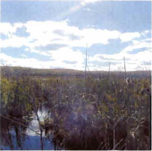
Figure 2: Hunt stand in Boulter-Depot Creek Conservation Reserve
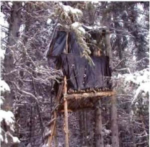
Figure 3: Snowmobile trail in Boulter Depot Creek Conservation Reserve
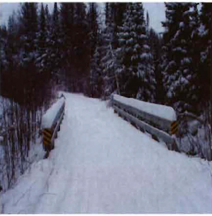
Figure 4: Blueseal Road and snowmobile trail south of Block B that is often flooded

1 Encyclopaedia Britannica, Inc. 2002. Encyclopaedia Britannica Online. www.britannica.com.
2 Dictionary.com. 2003. Lexico Publishing Group. www.dictionary.com
3 http://www.dnr.state.wi.us/org/land/parks/specificlkrnscenicdrive/glacialterminology.html (link no longer active)
4 Chapman, L.J, and D.F. Putnam. 1984. The Physiography of Southern Ontario, Third Edition. Ontario Geological Survey
5 OMNR. 1992. Ontario Provincial Parks: Planning and Management Policies: 1992 Update. OMNR
6 OMNR. 2001. Glossary. http://www.MNR.gov.on.ca/MNR/forests/forestdoc/ebr/fnnpdfs/glossary.pdf
7 OMNR. 1996. Forest Management Planning Manual. Toronto: Queen’s Printer for Ontario
8 Crins, William J and Peter W.C. Uhlig. 2002. Ecoregions of Ontario: Modifications to Angus Hills' Site Regions and Districts Revisions and Rationale
9 MNR. 1993. Ontario Wetland Evaluation System Northern Manual
10 Woods, M. 2004. Personal Communication at North Bay District MNR