Brokenmouth River Conservation Reserve Management Statement
This document provides policy direction for the protection, development and management of the Brokenmouth River Conservation Reserve and its resources.
Statement of Conservation Interest
Prepared for OMNR, Red Lake District
Joanne M. Stanley and Angie McLellan
Ontario’s Living Legacy Interns
June 24, 2003
Approval Statement
I am pleased to approve this Statement of Conservation Interest for the Brokenmouth River Conservation Reserve.
This Statement of Conservation Interest provides guidance for the management of the Conservation Reserve and the basis for the ongoing monitoring activities. Should significant facility development or resource management be considered, or complex issues develop requiring addi tional studies, a more detailed Conservation Reserve Management Plan will be prepared with full public consultation.
The public was widely consulted during the original regulation process for the Brokcnmouth River Conservation Reserve. Additional consultation is not required at this time, however, furt her consultation with Slate Falls First Nation is necessary before the Conservation Reserve can be regulated.
The Brokenmouth River Conservation Reserve will continue to be managed by the Red Lake South Area, Red Lake District, Ministry of Natural Resources.
Graeme Swariwick
District Maoager
Red Lake District
Date: July 17, 2003
Charlie Lauer
Regional Director
Northwest Region
Date: July 22, 2003
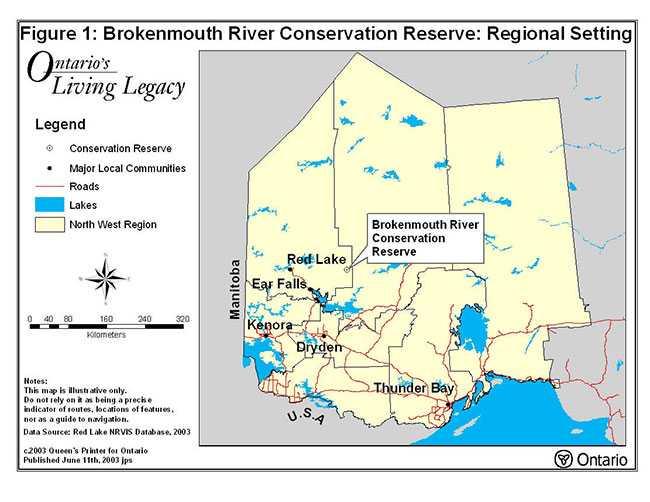
Figure 1: Brokenmouth River Conservation Reserve: Regional Setting
Enlarge Figure 1: Brokenmouth River Conservation Reserve: Regional Setting
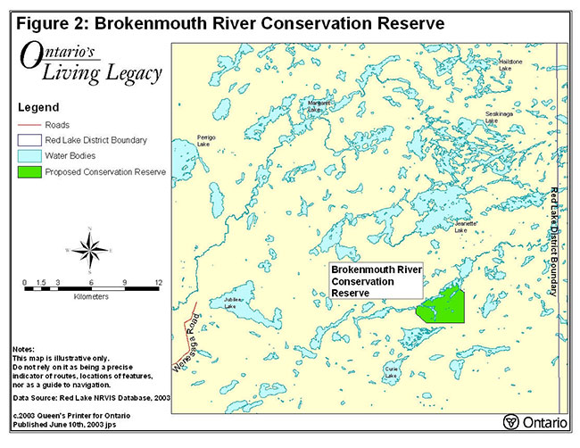
Figure 2: Brokenmouth River Conservation Reserve
Enlarge Figure 2: Brokenmouth River Conservation Reserve
1.0 Background Information
The purpose of this document is to identify the natural heritage values of the Brokenmouth River Conservation Reserve, as well as, identify the type and extent of current recreational use on-site. A set of management guidelines defines the activities that may or may not be permitted and the overall management direction for the area. For more information on a Statement of Conservation Interest, please refer to the Conservation Reserves Policy and Procedure PL3.03.05.
| Name | Brokenmouth River Conservation Reserve |
|---|---|
| Site Region / Site District | 3S – 2 |
| OMNR Administrative Region / District / Area | Northwest Region – Red Lake District – Red Lake South Area |
| Total Area (ha) | 1,087 |
| Regulation Date | Pending |
| First Nations | Nishnawbe-Aski First Nation’s Peoples, Treaty #9 |
| Latitude / Longitude | 51° 01' N 92° 08'W |
| Basemap | 556565, 555565, 555564, and 556564 |
| Forest Resource Inventory Stand Numbers | 403, 404, 504, 506, 508, 511, 512, 516 and others (2000 inventory) |
| General Location Description | The Brokenmouth River Conservation Reserve is located near the administrative boundary between Red Lake and Sioux Lookout districts. The Conservation Reserve is situated approximately 120 km east, northeast of Red Lake. |
| Access | This Conservation Reserve is largely inaccessible by land. The Rock Road (a secondary forestry access road) branches off the Wenasaga Road and ends approximately 7.5-km west northwest of this site. Access is currently limited to air or waterway (although there are no established canoe routes). |
1.1 Targets
This section provides a summary of the earth science, life science and cultural resource values as well as any present or possible recreational opportunities.
| Life Science Representation | The Conservation Reserve includes representative vegetation including mixed deciduous and coniferous forests. Recent burns on this site are repopulated with dense jack pine. The Conservation Reserve also includes poor conifer swamps and bogs with black spruce and stunted jack pine. Moose aquatic feeding areas are present. |
|---|---|
| Earth Science Representation | The landforms in this Conservation Reserve consist of weakly to moderately broken bedrock. A three phase unit of granitic rock was found: coarse grained, pegmatitic (very coarsely crystalline), and aplitic (very finely crystalline). Ground moraine till and boulder beaches are also present. Small ridges, either eskers or recessional moraines exist. |
| Cultural Resource Representation | No documented cultural heritage values have been identified. |
| Recreational Opportunities | Opportunities may exist for remote wilderness recreation with limited accessibility. Angling opportunities for sport fish exist. Activities with broad potential include general exploring, hunting opportunities and nature study. |
1.2 Survey Information
This section provides an overview of the completed inventories, the level of detail and any further inventories that are needed.
| Survey Level | Reconnaissance | Detailed | Additional Survey Required |
|---|---|---|---|
| Life Science | Completed Autumn 2001 | No | |
| Earth Science | Completed Summer 2001 | No | |
| Cultural | No | No | |
| Recreational Check Sheet | Completed Summer 2001 | No |
2.0 Values to be Protected
This section provides a description of the key natural heritage values on the Conservation Reserve, their condition relative to past resource use, management activities and their sensitivity to future land use, and management activities.
2.1 Values Identified on the Site
| Life Science | The Conservation Reserve includes representative vegetation including mixed deciduous and coniferous forests and treed wetlands. Dense jack pine populating over a recent burn is found. A moose aquatic feeding area is present. |
|---|---|
| Earth Science | The landforms in this Conservation Reserve consist of weakly to moderately broken bedrock. Ground moraine till and esker/recessional moraine ridges are present. |
| Cultural | None Identified. |
| Aboriginal | Nishnawbe-Aski Nation, Treaty # 9. A First Nation trapline covers most of the Conservation Reserve area and is operated by Slate Falls First Nation. |
| Tourism | Two commercial outpost camps are located adjacent to the Brokenmouth River Conservation Reserve. One located south on the north end of Una Lake and the other located northeast off the north end of a unnamed lake. Both lakes are part of the Brokenmouth River system. |
| Recreational Fishing | None are identified, however, there is potential for fishing on the Brokenmouth River from the Conservation Reserve. Access is limited. Nearby lakes show populations of northern pike and walleye |
| Recreational Hunting | The Brokenmouth River Conservation Reserve may be used for moose and small game hunting, however, access to the Conservation Reserve is limited. |
| Mining | Low mineral potential; the Conservation Reserve is withdrawn from staking. |
| Aggregates | No past or existing operations. |
| Forest Harvest | The Conservation Reserve is part of the Trout Lake Forest Management Unit and is currently under interim protection and will be withdrawn from the Sustainable Forest License |
| Trapping | There are two registered traplines located within the Conservation Reserve. SL191 (Aboriginal) and SL198 (Non-Aboriginal) are active and permitted to continue. |
| Bear Management Area | A BMA (SL-04-034) is located in a small portion of the northern boundary. |
| Commercial Fish | None identified, however, populations of whitefish, walleye, and northern pike have been identified in nearby lakes. The Brokenmouth River Conservation Reserve is also part of a commercial baitfish block. |
2.2 Values to be Protected
The intent of this Statement of Conservation Interest is to protect values by establishing management guidelines for existing and potential uses in this area, given the level of past disturbance and the nature of the existing features.
Major Representative Values: The Brokenmouth River Conservation Reserve is critical for representation of 2 LV-types in Site 3S-2: burn on moderately broken bedrock and conifer on moderately broken ground moraine. The Conservation Reserve is accessible by air or water only; the nearest forest access road terminates approximately 7.5 km to the west of the Conservation Reserve. No forest harvesting has occurred within the Brokenmouth River Conservation Reserve or immediately adjacent to it.
Forest Values: The Brokenmouth River Conservation Reserve is located in the Trout Lake Forest and is currently under interim protection. The Conservation Reserve will remain protected from forest management activities until the site is officially withdrawn from the Sustainable Forestry Licence (SFL) through the regulation process.
Recreational Values: The Brokenmouth River Conservation Reserve offers limited access (i.e. roads, navigable waters) and is located near the headwaters of the Brokenmouth River watershed. The Conservation Reserve may provide a starting point for canoe tripping on the Brokenmouth River that flows east into the Cat and Bamaji Lake water systems. There are no recreational development plans ongoing, however, remote fishing and hunting opportunities are available through the outpost camps on Una Lake and the unnamed lake to the northeast.
Tourism Values: The Brokenmouth River Conservation Reserve offers potential for Eco-tourism opportunities, however, the remote location may cause access challenges. Remote hunting and fishing opportunities are available through the commercial outpost camps adjacent to the Conservation Reserve.
3.0 Management Guidelines
3.1 Land Tenure
The Brokenmouth River Conservation Reserve will remain Crown land. No dispositions for private use (including Land Use Permits or Licences of Occupation) will be issued for the Conservation Reserve.
3.2 Existing and Proposed Development
To date there is no existing or proposed development within the Brokenmouth River Conservation Reserve. Development that would alter or disturb this site will not be allowed. The portion of the Brokenmouth River adjacent to the Conservation Reserve and the connecting water system within this Conservation Reserve is restricted to new boat caches. The two commercial outpost camps are located outside the Conservation Reserve and are currently licensed under a Land Use Permit. The capacity of this water system to support additional commercial sport fishing opportunities is limited. However, non-consumptive commercial opportunities may be considered outside the Conservation Reserve if those activities are determined not to have any detrimental impacts on the natural heritage values within the Conservation Reserve.
3.3 Recreational Activities
Recreational activity is permitted in the Brokenmouth River Conservation Reserve, although access is limited. Currently, there are no recreational trails available. Historical use of snowmobile trails can continue and will be revisited to reflect any changes. Although permitted, angling opportunities for sport fishing are limited within this Conservation Reserve. Hunting in Conservation Reserves is also permitted.
3.4 Commercial Activities
The Brokenmouth River Conservation Reserve is part of the Trout Lake Forest Management Unit and will be permanently removed from the Sustainable Forest Licence held by Weyerhaeuser Company Limited. An examination of the possible impact of activities on adjacent lands should be evaluated in the Forest Management Plan.
The Ministry of Northern Mines and Development (MNDM) have also withdrawn the Conservation Reserve from all mineral exploration and extraction activities.
There are two registered traplines located within the Brokenmouth River Conservation Reserve, SL191 and SL198 are active and permitted to continue.
The Conservation Reserve contains a Bear Management Area in the northeastern section, however, the remainder of the Conservation Reserve is not under a Bear Management Area agreement.
A commercial boat cache is held on the edge of the Brokenmouth River Conservation Reserve. Owners of this cache are permitted to continue usage within the Conservation Reserve boundaries, under their Boat Cache Agreement. No new boat caches will be permitted in the Conservation Reserve.
No other commercial activities exist within the Conservation Reserve. Activities, such as mining, aggregate or peat extraction, commercial logging, hydroelectric power development, utility corridors, highways and/or roads, will not be permitted.
3.5 Aboriginal Interests
Traditional land use in the Brokenmouth River Conservation Reserve involves the Nishnawbe-Aski First Nation whose interests include an active registered trapline, sustenance hunting and wild rice harvesting. The Brokenmouth River Conservation Reserve does not intend to affect existing or future Aboriginal or treaty rights.
3.6 Natural Resources Stewardship
3.6.1 Vegetation Management
The Brokenmouth River Conservation Reserve is located within the Trout Lake Forest Management Unit and within the Boreal Zone of the West Fire Region. Fire occurrences will be considered a high priority for action, however, in order to maintain the ecological integrity of this site, the role of fire must be considered. The Ministry of Natural Resources recognize fire as an essential process in the maintenance and renewal of ecological sustainability and ecosystem health. Fire may be allowed to fulfil its natural role in designated areas of the Conservation Reserve. Fire and resource managers will identify those areas and the specific conditions under which prescribed and natural fire may be used to meet resource management objectives. Prescribed burning may be used, in accordance with Ministry of Natural Resources policy and guidelines to achieve resource management objectives within a Conservation Reserve.
Flexibility in suppressing low-risk fire occurrences within this Conservation Reserve will be evaluated through a more detailed local natural resource plan or fire management plan. Until a fire management plan is prepared, all wildfires will be dealt with according to the Fire Management Objectives of the surrounding Fire Management Zone.
3.6.2 Fish and Wildlife Management
The existing Wildlife Management Unit, regulations for sport fishing, and their management activities will apply to facilitate the management of fish and wildlife in this Conservation Reserve.
3.6.3 Landforms
No management activity is required except protection.
3.7 Cultural Resources Stewardship
No management activity is required at this time based on existing information. Cultural, historical and archaeological features were not identified when reviewing background information and research, nor were they identified during the site visit.
3.8 Client Services
There are no established client services for the Brokenmouth River Conservation Reserve at this time, nor are there any immediate plans for developing such client services. Information on resources of this Conservation Reserve is available from the Red Lake District Office.
3.9 Research
Non-destructive research related to the study of earth and life sciences will be encouraged in this Conservation Reserve.
3.10 Marketing
No marketing activity is required at this time.
4.0 Implementation
Implementation of these management guidelines is the responsibility of the Red Lake South Area Supervisor, Red Lake District. Any affected interest groups or clients will be immediately informed of proposed changes to this Statement of Conservation Interest.
5.0 Review and Revisions
The Brokenmouth River Conservation Reserve Statement of Interest will be reviewed on an ongoing basis.
If changes in management direction are needed at any time, the significance of the changes will be evaluated. The need for public notice or more formal consultation will be assessed. Major amendments will require full public consultation and the approval of the District Manager and the Regional Director.
6.0 Public Consultation
6.1 Results of Past Consultation
The Land Use Strategy established the Ministry’s intent to add these Crown lands to Ontario’s protected areas system, following the extensive public consultation associated with the Ontario’s Living Legacy and Lands for Life land use planning initiatives between 1997 and 1999.
Local First Nation communities received an information package and invitations to participate in the consultation process for Conservation Reserves within the Trout Lake Forest including the Brokenmouth River Conservation Reserve. These communities included: Cat Lake First Nation, Grassy Narrows First Nation, New Slate Falls First Nation, Pikangikum First Nation, and Wabauskang First Nation. The Brokenmouth Conservation Reserve falls within the traditional use area of the New Slate Falls community with some overlap with the Cat Lake First Nation. Follow up consultation for this site is being pursued with both communities.
In November 2000, a meeting was held in Red Lake with Chief Ron Wesley of Cat Lake and a representative of the Windigo Tribal Council regarding Gull-Christina and Brokenmouth River Conservation Reserves. Attempts were made for subsequent meetings.
6.2 Present and Future Consultation
There was no comment received from New Slate Falls during the public consultation period. Up to present, no consultation has occurred with New Slate Falls however; meetings are scheduled for July of 2003.
Further widespread consultation is not deemed necessary at this time, as there has been an absence of proposals for significant resource management or development activities. Additionally, there was no public comment documented during the consultation period in response to the Brokenmouth River Conservation Reserve.
Present and future consultation with Nishnawbe-Aski First Nation is ongoing and will continue as Aboriginal interests arise.
7.0 References
Noble, T.W. Site Region 3S Gap Analysis. Draft Copy. Ontario Ministry of Natural Resources, Northwest Region, Thunder Bay, Ontario, 1998.
Ontario Ministry of Natural Resources Red Lake District, Jeanette Lake Survey, 1978.
Ontario Ministry of Natural Resources, Conservation Reserves Policy and Procedure (PL 3.03.05). 1997.
Ontario Ministry of Natural Resources, Ontario’s Living Legacy - Land Use Strategy, July 1999.
Ontario Ministry of Natural Resources, Ontario Provincial Parks Planning and Management Policies, 1992 Update.
Appendix A: Life Science Check Sheet
C2303 Brokenmouth River Conservation Reserve
Natural Heritage Area – Life Science Checksheet
| Name: | C2303 Brokenmouth River | |||||
|---|---|---|---|---|---|---|
| Map Name: | Jeanette Lake | |||||
| Map Number: | 52N/1 | |||||
| UTM Ref.: | Zone 15 560400 E 5650000 N | |||||
| County: | Kenora | |||||
| Lattitude: | 51° 1' N | |||||
| Longitude: | 92° 8'W | |||||
| NAD: | 83 | |||||
| Minimum Altitude: | 410 m | |||||
| Maximum Altitude: | 460 m | |||||
| Locality | Approx. 90 km NE of Sioux Lookout Approx. 120 km E of Red Lake | |||||
| Township | unorganized | |||||
| Area | 1071 ha | |||||
| Ownership | Crown | |||||
| MNR Region | Northwest | |||||
| Landform Unit(s) | See Table 3 | |||||
| Ecoregion and Ecodistrict | 3S-2 | |||||
| MNR District | Red Lake | |||||
| Aerial Photographs Year-Roll-Flight Line-Numbers |
96-5101 04-39 | |||||
Physical and Biological Features
The Brokenmouth River Conservation Reserve incorporates waters of the Brokenmouth River west of St Ours Lake and lands south towards Una Lake. A total of 82 ha of water is included in the Conservation Reserve, of which the Brokenmouth River accounts for 66 ha and the rest is comprised of small lakes and ponds.
Dense conifer forests on moderately broken bedrock and shallow ground moraine is the predominant LV-types in the Conservation Reserve, accounting for approximately 53% of the landbase. Jack pine and black spruce dominate the landscape on shallow sandy and coarse loamy soils with ES12 and ES20 is common. The sparse understory is comprised of Canada mayflower, bunchberry, and Schreber’s moss. These even-aged stands are often of fire origin. Recent wildfire has reduced the area of sparse coniferous forest in the Conservation Reserve over 300 ha (interpreted from Landsat 28) to 20 ha (sparse forest LV-type total). As a result, burns on moderately broken bedrock and ground moraine are next most common LV-types.
Mixed forests and deciduous forests occur primarily on glacial outwash and deeper morainal tills over bedrock in the southeastern portion of the Conservation Reserve. Soils are finer textured e.g. silty clay loam, and more mesic.
Approximately 120 ha of open and treed fen, bog, and poor conifer swamp are found on organic deposits that have accumulated in low local relief and in sheltered embankments of the unnamed lake and Brokenmouth River. Stunted black spruce, tamarack, and jack pine are found in the treed condition (e.g. ES40, ES34) with abundant ericaceous shrubs and Sphagnum as the predominant ground cover.
The stained, shallow waters of the Brokenmouth River support walleye, northern pike, and other fish species.
Representation
The Brokenmouth River Conservation Reserve is critical for representation of two LV-types in S3-2: burn on moderately broken bedrock and conifer on moderately broken ground moraine. The Conservation reserve also has good representation of burn on moderately broken ground moraine (103 ha) and treed wetland on moderately broken bedrock (65 ha). Brokenmouth River was considered representative of 11 other LV-types, although, their occurrence was limited in the Conservation Reserve (<25 ha for each LV-type). The Conservation Reserve has identified 288 ha as representative for conifer on moderately broken bedrock.
Condition
The Brokenmouth River Conservation Reserve is naturally evolving with limited access and use to date. The Conservation Reserve is accessible by air or water and the nearest forest access road terminates approximately 15 km to the west of the Conservation Reserve. No forest harvesting has occurred within the Conservation Reserve or immediately adjacent to it.
Remote tourism is the primary use of the Conservation Reserve. There is an outpost camp located on the east shore of unnamed Lake, approximately 2 km from the Conservation Reserve’s eastern boundary and immediately south off the north shore of Una Lake. There is also a commercial boat cache located on along the north shore of the Brokenmouth River just outside the northwestern boundary of the Conservation Reserve. The rapids between the unnamed lake and Brokenmouth River to the west are travelable during high water.
Diversity
The Conservation Reserve has a moderate diversity of LV-types and species. Only a few LV-types account for most of the Conservation Reserve: moderately broken bedrock or ground moraine dominated by conifer or burn. At this latitude, these habitats are strongly boreal in character and are not particularly species-rich. The wetlands, riparian areas, and waters of the Brokenmouth River add to the diversity of habitats and species, however the short species list reflects, in part, the limited fieldwork and access.
Ecological Considerations
Fire history maps indicate that 140 ha burned during the 1960s in the southeastern portion of the Conservation Reserve. Remote sensed data classify 291 ha as burn or % of the land base of the Conservation Reserve. Fire is the dominant disturbance in the Conservation Reserve and 3S-2. Frequent small and occasional large fires that burn proportionally more of the land base are typical of the fire regime for this Site District.
No major pest outbreaks or blowdown events are documented for the Conservation Reserve.
The small size of the Conservation Reserve makes it sensitive to edge effects and there is a limited core area for sensitive species. Fortunately, there has been disturbance of the landscape immediately surrounding the Conservation Reserve.
Special Features
A cow and calf moose were observed feeding in the 15 m wide creek on the eastern boundary of the Conservation Reserve and in the adjacent waters of the unnamed lake. No moose aquatic feeding area surveys have been done for the Conservation Reserve since it is not currently an area of active forest management. The moose were feeding on floating bur-reed in the slow moving stream fringed by wire sedge shore fen (W14).
The Brokenmouth River is within the range of wolverine (Gulo gulo), although there is no documented evidence of their presence in the Conservation Reserve. This vulnerable species (S2) requires large, sparsely inhabited wilderness areas with adequate year-round food supplies. The Confederation Lakes area appears to have a significant concentration of wolverine (Dawson 2000), and is only 20 km northwest of Brokenmouth River. The Conservation Reserve could potentially contribute towards wolverine habitat requirements in a landscape context.
Recommendations
Conduct surveys for wolverines to verify their presence and use of the Conservation Reserve. Wolverine survey methods could include photographic bait stations, track plates, and/or snow track surveys. Track surveys could potentially be combined with moose and caribou aerial surveys.
Significance Level and Summary of Major Representative Values
The Brokenmouth River Conservation Reserve is critical for representation of 2 LV-types in 3S-2: burn on moderately broken bedrock and conifer on moderately broken ground moraine. The Conservation Reserve also has good representation of burn on moderately broken ground moraine.
Major Information Sources
Dawson, N. 2000. Draft report on the status of the wolverine (Gulo gulo) in Ontario. Report prepared for the Committee on the Status of Species at Risk in Ontario (COSSARO). Ont. Min. Nat. Resour., Thunder Bay, ON. 38p.
Harris, A.G., S.C.McMurray, P.W.C.Uhlig, J.K.Jeglum, R.F.Foster and G.D. Racey. 1996. Field guide to the wetland ecosystem classification for northwestern Ontario. Ont. Min. Natur. Resour., Northwest Sci. & Technol. Thunder Bay, Ont. Field Guide FG-01. 74 pp. + Append.
Noble, T. 1995. Site Region 3S Gap Analysis. Unpublished report for Ontario Parks, Ont. Min. Natur. Resour. Thunder Bay, Ont. 28 p. + appendices.
OMNR. 1999. Ontario’s Living Legacy – Land Use Strategy. Queen’s Printer, Toronto.
Racey, G.D., A.G. Harris, J.K.Jeglum, R.F.Foster and G.M.Wickware. 1996. Terrestrial and wetland ecosites of northwestern Ontario. Ont. Min. Natur. Resour., Northwest Sci. & Technol. Thunder Bay, Ont. Field Guide FG-02. 88 pp. + Append.
Sims, R.A., W.D. Towill, K.A. Baldwin, P. Uhlig and G.M. Wickware. 1997. Field guide to the forested ecosystem classification for northwestern Ontario. Ont. Min. Natur. Resour., Northwest Sci. & Technol. Thunder Bay, Ont. Field Guide FG-03. 176 p.
Date Compiled:
28/07/03
Compiled Compiler(s):
Robert Foster, Allan Harris
Northern Bioscience
Appendix B: Earth Science Check Sheet
Detailed information for site C2303 Brokenmouth River
Protection history
The Brokenmouth River Conservation Reserve was identified under the provincial Lands for Life - Ontario’s Living Legacy Program. The Conservation Reserve was principally identified for its life science representation, the only previously identified earth science feature being ground moraine.
Setting
Brokenmouth River Conservation Reserve incorporates lands along the Brokenmouth River between unnamed lake to the north and Una Lake to the south. The Conservation Reserve comprises 844 hectares of Crown land located in Red Lake MNR District. Elevations range from 420 m to 450 m. The Conservation Reserve appears to have undergone no previous disturbance however it was part of the 1961 burn.
Earth science features:
Bedrock Geology
The Brokenmouth River Conservation Reserve lies entirely within Uchi subprovince of the Archean Superior Province. Outcrop density varies from about 30% in the north and west to probably <5% in the southeast, where ground moraine and glaciofluvial deposits predominate. The Conservation Reserve is probably underlain by a single unit of granodioritic rocks, that vary in texture from equigranular, medium to coarsely crystalline (photo 1) to pegmatitic (photo 2). Contacts between the equigranular and pegmatitic phases are irregular and indistinct, indicating that the pegmatites are not dikes, but of the same generation as the dominant equigranular phase. Though predominantly massive, ghost-like xenoliths of more mafic rock define a weak foliation trend in places (photo 3). Very large crystals of potassic feldspar, up to 30 cm across accompanied by quartz crystals up to 10 cm across were observed (station 1). No systematic mapping has been done in this area, however, mapping immediately to the south of latitude 51° (Breaks et al 1976) indicates similar rocks: the Conservation Reserve is within a large granitic batholith centred on Jeannette Lake.
Surficial Geology
Shallow ground moraine appears to overlie bedrock in the north and east of the Conservation Reserve, whereas thickness increases in the southeast, with consequent decrease in bedrock outcrop. Glacial outwash or esker deposits occur within the extreme south-east corner. These deposits are part of a series of west, south-west trending eskers that occur in this part of north-western Ontario, fanning out from the Agutua moraine in the north-east toward Lac Seul moraine in the south-west (Barnett et al 1991; Sado and Carswell 1987). A series of short, curvilinear ridges were observed from the air in the southeast part of the Conservation Reserve. Their long axes trend north, northwest, transverse to the west, south-west trend of the eskers. The eskers have been interpreted on maps (Barnett et al 1991; Sado and Carswell 1987) as DeGeer moraines, thought to have formed on a cyclical, possibly annual basis, by glacial retreat. Material that forms islands with similar orientation was also observed from the air outside of the Conservation Reserve to the southwest at Una Lake, are probably of the same generation. Boulder beaches were also observed from the air within and in the vicinity of the Conservation Reserve.
Significance:
The granitic bedrock is typical of vast tracts of the Precambrian Shield of northwestern Ontario, however, not easily accessible and not particularly well exposed. Shallow ground moraine is not overly exposed and not considered significant. The esker in the southeast was not observed on the ground, not well exposed and only a very small portion of a much larger feature and therefore not significant. The DeGeer moraines were observed and interpreted from the air only. They are representative of such landforms in this part of northwest Ontario, and are considered to be of local significance.
Sensitivity:
Currently, no earth science features or landforms within the Conservation Reserve appear sensitive to natural impacts. The DeGeer moraines and esker deposits may be sensitive to exploitation for gravel resources.
Recommendations:
The DeGeer moraines are earth science features that are considered to be significant. The moraines were observed form the air only, both within the present Conservation Reserve and outside of the Conservation Reserve at Una Lake. Consideration should be given to further investigation on the ground to verify the interpretation. Should the interpretation be positively determined, consideration may be given to extending the Conservation Reserve to incorporate these features at Una Lake.
Bedrock was observed along the northern edge of the Conservation Reserve. Inquiries should be made during any further investigation of the DeGeer moraines.
References:
Barnett, P.J., Henry, A.P. and Babuin, D. 1991. Quaternary Geology of Ontario, west-central sheet; Ontario Geological Survey, Map 2554, scale 1:1 000 000.
Breaks, F.W. Bond, W.D., Stone, D., Harris, N. and Desnoyer, D.W. 1976. Operation Kenora-Ear Falls, Papaonga-Wapesi Laks Sheet, District of Kenora; Ontario Geological Survey, Map P.1200, scale 1:63 360.
Sado, E.V. and Carswell, B.F. 1987. Surficial Geology of Northern Ontario; Ontario Geological Survey, Map 2518, scale 1:1 200 000.
Date Compiled:
Summer 2001
Consulting
Compiler(s):
Robert Foster, Allan Harris
Northern Bioscience Ecological
Appendix C: Recreation Check Sheet
Recreation Invetory Checklist
| Name: | Brokanmouth River Conservat on Reserve |
|---|---|
| Map Name: | G2078,G1998 |
| NTS Number | 52N/1-57K/16 |
| UTM Reference: | E559753 - N5651661 |
| OBM Number | 55565, 55564, 56565, 56564 |
| Lattitude: | 51°01' N |
| Longitude: | 92°08' W |
| Area (ha) | 1,071,00 |
| Ownership | Crown |
| MNR Region | Northwest |
| MNR District | Red Lake |
| Park Zone | Northwest |
| Count | N/A |
| Township | N/A |
| Recreation Features |
|
| Recreation Activities |
|
| Recreation Factors | Features | Rating Very High/High/Moderate/Low/N/A |
|---|---|---|
| Most Scarce Features | 4 | |
| Feature Scarcity | N/A | Moderate |
| Most Unique Feature | ||
| Activity Altraction Capability | Low | |
| Scenic Altractiveness | Modearte | |
| Geographic Significance | Low | |
| Feature Significance: | Low | |
| Most Sensitive Features to Recreation Use | 5 | |
| Feature Sensitivity to Recreation Use: | Moderate | |
| Most Sensitive Feature to Resource Development | 4 | |
| Feature Sensitivity To Resource Development | High | |
| Cultural/Historic and Archaelogical Features: | N/A |
Comments: N/A
Date Compiled:
Tuesday, August 28, 2001
Compiler:
Joanne Stanley
Appendix D : Crown Land Atlas
Policy Report
Ministry of Natural Resources
Crown Land Use Atlas – Policy Report
C2303
Brokenmouth River
Updated: June 24, 2003
Identification:
ID: C2303
Area Name: Brokenmouth River
Area (ha): 1, 071
Designation: Conservation Reserve (Ontario’s Living Legacy)
District(s): Red Lake
Description:
The Brokenmouth River Conservation Reserve is located in both the Red Lake and Sioux Lookout districts. This site contains representative landform and vegetation types, including mixed forest types and burns on moderately broken bedrock and ground moraine. Una Lake immediately to the south and a unnamed lake to the north are designated tourism lakes.
Land Use Intent:
The intent is to regulate this area as a Conservation Reserve. Management of this area is also governed by the general policies contained in the Land Use Strategy (1999).
Management Direction:
Uses and management activities not listed in the following table are governed by the existing Conservation Reserve policy and the Brokenmouth River Statement of Conservation Interest (June 2003). Any new uses, and commercial activities associated with Conservation Reserves, will be considered on a case by case basis, and they must pass a test of compatibility to be acceptable. Compatibility is normally determined through a planning process.
Commercial activities
| Activity | Permitted | Guidelines |
|---|---|---|
| Aggregate Extraction | No | |
| Bait Fishing Existing: | Yes | Existing use permitted to continue, unless there are significant demonstrated conflicts. |
| Bait Fishing New: | Maybe | New operations can be considered, subject to the "test of compatibility" |
| Commercial Fishing Existing: | Yes | Existing use permitted to continue, unless there are significant demonstrated conflicts. |
| Commercial Fishing New: | Maybe | New operations can be considered, subject to the "test of compatibility". |
| Commercial Fur Harvesting Existing: |
Yes | Existing use permitted to continue, unless there are significant demonstrated conflicts. Existing trap cabins can continue; new cabins are not permitted. |
| Commercial Fdur Harvesting New: |
Maybe | New operations can be considered, subject to the "test of compatibility". |
| Commercial Hydro Development | No | |
| Commercial Timber Harvest |
No | |
| Commercial Tourism Existing: | Yes | Existing authorized facilities can continue, unless there are significant demonstrated conflicts. |
| Commercial Tourism New: | Maybe | New tourism facilities can be considered during the planning for an individual reserve. |
| Bear Hunting by Non residents (guided) Existing: | Yes | Existing authorized operations permitted to continue. |
| Bear Hunting by Non residents (guided) New: | No | New operations not permitted. |
| Outfitting Services Existing: | Yes | Existing authorized operations permitted to continue. |
| Outfitting Services New: | Maybe | New operations can be considered during the planning for an individual reserve. |
| Outfitting Services Existing: | Yes | Existing authorized operations permitted to continue. |
| Outfitting Services New: | Maybe | New operations can be considered during the planning for an individual reserve. |
| Outpost Camps Existing: | Yes | Existing authorized facilities permitted to continue. |
| Outpost Camps New: | Maybe | New facilities can be considered during the planning for an individual reserve. |
| Resorts/lodges Existing: | Yes | Existing authorized facilities permitted to continue. |
| Resorts/lodges New: | Maybe | New facilities can be considered during the planning for an individual reserve. |
| Energy Transmission and Communications Corridors Existing: | Yes | These facilities should avoid conservation reserve lands wherever possible. |
| Energy Transmission and Communications Corridors New: | No | |
| Food Harvesting (Commercial) Existing: | Maybe | |
| Food Harvesting (Commercial) New: | Maybe | |
| Mineral Exploration and Development | No | |
| Peat Extraction | No | |
| Wild Rice Harvesting Existing: | Yes | |
| Wild Rice Harvesting New: | Maybe |
Land and resource management activities
| Activity | Permitted | Guidelines |
|---|---|---|
| Crown Land Disposition Private Use: | Maybe | Sale of lands is not permitted, except for minor dispositions in support of existing uses (e.g. reconstruction of a septic system). Renewals of existing leases and land use permits are permitted. Requests for transfer of tenure will be considered in the context of the Statement of Conservation Interest or Resource Management Plan. |
| Crown Land Disposition Commercial Use: | Maybe | New leases or land use permits permitted for approved activities. Tourism facilities can apply to upgrade tenure from LUP to lease. |
| Fire Suppression | Yes | Fire suppression policies are similar to adjacent Crown lands, unless alternative fire policies have been developed through a planning process. |
| Fish Habitat Management | Maybe | |
| Fish Stocking | Maybe | Existing authorized operations permitted to continue. New operations not permitted. |
| Inventory/disease Suppersion | Maybe | |
| Inventory/Monitoring | Maybe | |
| Prescribed Burning Roads (Resource Access) Existing: | Yes | Existing roads can continue to be used. Continued use will include maintenance and may include future upgrading. |
| Prescribed Burning Roads (Resource Access) New: | Maybe | New roads for resource extraction will not be permitted, with the exception of necessary access to existing forest reserves for mineral exploration and development. |
| Vegetation Management | Maybe | Conservation Reserves policy indicates that Featured Species Management and Natural Systems Management may be permitted. Vegetation management can be considered in a planning process. |
| Wildlife Population Management | Maybe |
Science, education and heritage appreciation
| Activity | Permitted | Guidelines |
|---|---|---|
| Collecting | No | |
| Historical Appreciation | Yes | |
| Nature Appreciation | Yes | |
| Photography and Painting | Yes | |
| Research | Yes | |
| Wildlife Viewing | Yes |
Recreation activities and facilities
| Activity | Permitted | Guidelines |
|---|---|---|
| All Terrain Vehicle Use On Trails: | Yes | Existing use permitted to continue where it does not adversely affect the values being protected. ATV use off trails is not permitted except for direct retrieval of game. |
| All Terrain Vehicle Use Off Trails: | No | |
| Campgrounds | Maybe | |
| Food Gathering | Yes | |
| Horseback Riding(trail) | Yes | Existing use on trails permitted. |
| Hunting | Yes | |
| Mountain Bike Use | Yes | Existing use on trails permitted. |
| Motor Boat Use Commercial: | Yes | |
| Motor Boat Use Private: | Yes | |
| Non-motorized Recreation Travel | Yes | |
| Private Recreation Camps (Hunt Camps) Existing: | Yes | |
| Private Recreation Camps (Hunt Camps) New: | No | Existing camps permitted to continue, and may be eligible for enhanced tenure, but not purchase of land. |
| Rock Climbing | Maybe | |
| Snowmobiling On Trails: | Yes | Existing use permitted to continue where it does not adversely affect the values being protected. |
| Snowmobiling Off Trails: | Maybe | Snowmobile use off trails is not permitted, except that snowmobiles may be used for direct retrieval of game. |
| Sport Fishing | Yes | |
| Sport Fishing Trail Development Existing: | Yes | Development of trails for a variety of activities (e.g. hiking, cross-country skiin, cycling, horseback riding, snowmobiling) can be considered as part of planning for an Individual reserve. |
| Sport Fishing Trail Development New: | Maybe |
Note: The policies outlined in this table do not supercede any Aboriginal or Treaty rights that may exist, or other legal obligations.
Source of Direction:
Ontario’s Living Legacy Land Use Strategy (1999).
Conservation Reserves Policy (1997)
Brokenmouth Statement of Conservation Interest (2003)