Bronte Creek Provincial Park Management Plan
This document provides direction on the management of Bronte Creek Provincial Park.
Note: This document has been scanned and formatted, and therefore is slightly different from the original version. – March 2002
Single copies of this publication are available at no charge from the address noted below. Bronte Creek Provincial Park
1219 Burloak Drive
Burlington, Ontario
L7R 3X5
Telephone:
4117-2
(1.0 K.P.R., 98 03 27)
ISBN 0-7778-7328-1
Approval statement
I am pleased to approve the Bronte Creek Provincial Park Management Plan. This plan will guide future management and development of the park in its evolution as the gateway to the Provincial Parks system in Ontario.
This plan reflects Ontario Parks' commitment to protect the significant natural and historic resources, offer enhanced educational opportunities and accommodate an exciting range of recreational uses. It also recognizes and commits Ontario Parks to the establishment of appropriate partnerships and linkages within the community and beyond to help us move forward with the careful implementation of the plan.
Norm Richards
Ontario Parks
Managing Director
Date: March 27, 1998
In 1994, the Ministry of Natural Resources finalized its Statement of Environmental Values (SEV) under the Environmental Bill of Rights (EBR). The SEV describes how the purposes of the EBR are to be considered whenever decisions that might significantly affect the environment are made by the Ministry. The SEV was considered by Ontario Parks during the development of the Management Plan for Bronte Creek Provincial Park. The plan is intended to reflect the directions set out in the SEV and to further the objectives of managing the park’s resources on a sustainable basis.
1.0 Introduction and acknowledgements
The establishment of Bronte Creek Provincial Park in 1972 as a near urban provincial park heralded a new era for Ontario’s provincial park system. The park was first put into regulation in 1975 (O. Reg. 661/75) and subsequently in 1979 (O. Reg. 151/79) for a boundary amendment. A Park Master Plan was prepared in 1972 and reviewed in 1990.
Bronte Creek Provincial Park was, and continues to be, a departure from tradition. It lies at the doorstep of over five million people. In less than twenty years, the park will be surrounded by the expansion of neighboring communities. In the early 1970's, Bronte Creek was proclaimed Ontario’s first near urban park. Today, Bronte Creek is an urban provincial park.
This plan is a review of the 1990 management plan. It is also the first management plan prepared for an operating park since Ontario Parks was established in 1996 as a new business model for managing the provincial park system. This plan focuses on current park values, the changing setting of the park and opportunities afforded by the Ontario Parks new business model. It will guide the protection, long term planning, development and management of what is "nearby and natural", as well as foster opportunities for partnerships as they arise.
The concepts and direction provided in this plan come from many voices in the community. Representatives from agency and volunteer organizations, park veterans and newcomers, children and seniors, daily users and repeat visitors, seasonal permit holders and first time users, park staff and volunteers, neighbours, tourists and business interests all provided suggestions, ideas and feedback on the draft plan and the concepts to revitalize the park. Their contribution was substantial and their insights invaluable to the future planning of Bronte Creek Provincial Park.
2.0 Bronte Creek Provincial Park today
Bronte Creek Provincial Park is endowed with a river valley rich in beauty and ecological significance. The Bronte Creek valley corridor is designated as a provincially significant life science resource. It is the least disturbed and most continuous river valley system on the southward sloping shale plains north of Lake Ontario.
Provincially significant archaeological and historical values are manifest in the heritage sites, farmstead and buildings found in the park. These features have been well documented in earlier plans.
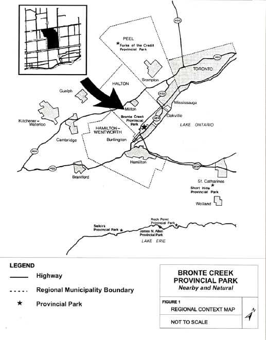
Bronte Creek Provincial Park is an oasis in a developing urban landscape. Located within the Regional Municipality of Halton immediately north of the Queen Elizabeth Highway on the Burlington-Oakville boundary (Figure 1) the park is surrounded by three major highway arteries. Development continues to expand along all of its boundaries. The population in the Regional Municipality of Halton, including the municipalities adjacent to the park, is projected to grow to almost 500,000 by the year 2011 (Regional Municipality of Halton, 1997).
Figure 1: Regional Context Map
Bronte Creek is a recreation class provincial park. In 1996, over 300,000 people came throughout the year to hike the valley, fish the creek, swim in the pool, picnic with family and friends, enjoy park programs, visit the farms, walk their dogs, skate, ski and toboggan. Park visitors represent over twenty- five known language groups and include a spectrum ranging from young families to seniors.
The valley system forms a natural barrier by dividing the park into two distinctive landscapes, which attract very different user groups.
The area north of the valley is used primarily by hikers, mountain bikers, dog walkers, horseback riders and anglers. Many are local users and come daily throughout the year. Free access is provided from the western extension of Upper Middle Road from Highway 25. The area is unstaffed and no formal programs or services are offered. The vegetation is gradually returning to a more natural state from former agricultural fields.
The area south of the valley is commonly understood to be the extent of the provincial park. It is accessed by the main gate off Burloak Drive. It offers a tremendous variety of facilities and activities:
- family and group picnic facilities
- a children’s farm
- a working turn-of-the century farm and museum;
- nature programs and exhibits
- a variety of sports amenities and popular seasonal activities such as sunbathing, swimming, tobogganing, skating
- park events, including those organized by the Friends of Bronte Creek Park, the community and private sponsors
- recreational equipment rentals and fast food services provided by a private concessionaire
- trails including a fitness trail and opportunities for cycling, hiking and cross-country skiing
The area is heavily used during summer weekends by picnickers, especially family and group gatherings. Midweek, the Children’s Farm and programming centre are the focus of attention. Fair weather summer days see crowded swimming pool and children’s day camps. Shoulder seasons attract hikers and cyclists and visitors to seasonal programming, while skating is popular during the winter months.
The Friends of Bronte Creek Park formed in January of 1995 as a not-for-profit, volunteer organization to work in cooperation with the park to augment its heritage protection and education programs. They play an important role by raising funds to support heritage education programs and by helping to deliver special events and awareness initiatives.
3.0 The park vision
The community sees a great and vital future for Bronte Creek Provincial Park. The park provides outstanding natural and cultural heritage resources, but it is seen to offer much more. Three concepts arise for Bronte Creek Provincial Park:
The Gateway to Ontario’s provincial park system.
An Oasis for recreation - nearby and natural.
A Linkage to other communities, regions and park systems.
3.1 The Gateway
Bronte Creek is within one hour’s drive of several million potential visitors. It also lies along the Queen Elizabeth Way, a highway used by millions of tourists each year. What better place to introduce and celebrate the Ontario Parks endowment of 272 provincial parks with over 7.1 million hectares? Ontario’s provincial park system, larger than the combined area of all U.S. state park systems and features world class landscapes and heritage resources that all Ontarians can be proud of. Bronte Creek provides an ideal platform to showcase the provincial parks system. The natural features of the park and future developments could provide the visitor with a taste of the natural, cultural and recreational experiences to be found throughout the provincial park system. Future promotional material could read:
"Come to Bronte Creek and discover the entire Ontario Parks system — parks such as Algonquin, Sandbanks, The Massasauga, Killbear, Wasaga Beach and Polar Bear. See, hear and smell a glimpse of Ontario’s natural legacy - nearby and natural. Experience environmentally sustainable development first hand, understand the sense of wellness that being close to nature can bring, and feel a part of global conservation. Share the ethic of caring for land and others at Bronte."
Bronte Creek’s location and visitation offer a unique opportunity to introduce and impart information on the use, protection and enjoyment of Ontario’s land, soil and water resources to the fastest growing urban population centre in the nation. The park’s location, significant population base and access to institutions, business and associations provide an opportunity for Bronte Creek to contribute to the development of management strategies for park systems in Ontario and elsewhere. Bronte Creek can be a gateway to many places, to many levels of endeavour and to managing park systems in the next millennium.
3.2 The Oasis
Bronte Creek is an oasis for many. Its expanse of green offers relief from urban living conditions. The heritage farm, playing fields, recreation complex and large picnic areas provide opportunities for large groups to come together for family, community and office gatherings. There could be many more recreation opportunities. Interest in a family garden plot available today could be broadened into an eagerness to help care for orchards, farm animals and could focus the visitor on broader issues of sustainability and health of Ontario’s ecosystems. Participation as a volunteer at Spruce Lane Farm and membership with the Friends of Bronte Creek afford a form of intellectual oasis by providing opportunities to become directly involved with the delivery of protection, recreation and heritage appreciation objectives of the park.
The north part of the park provides a dramatic contrast to smaller, more manicured urban parks. In the next ten to twenty years the park’s role as an Oasis will be accentuated as residential and industrial development intensifies. Bronte Creek can be an oasis for conservation and environmental organizations by offering a place to develop a central administration, shared educational facilities and staffing. Promotion as an oasis for research on park management, user trends and conservation techniques could also be pursued. Bronte Creek as an oasis will endure forever with the care, co-operation and commitment of the entire community.
3.3 Linkages
Bronte Creek provides a great range of opportunities for linkages. Physically, the park can be linked through the community from the Lakeshore to the Niagara Escarpment. Bronte Creek is presently accessible by car. It could be linked by bicycle, hiking and public transit routes to surrounding communities and to recreational opportunities. Its programs can serve to link environmental knowledge, experience and wisdom across Canada and globally.
By means of effective partnerships, the park can link institutions, parks and non-governmental organizations (NGOs) in applied research and program delivery through the presentation and protection of park systems. Programs can also link municipal, regional, provincial and federal governments in park programming.
Bronte Creek’s programs and services can serve to link Ontario’s diverse communities while connecting citizens to the heritage of Ontario, to its aboriginal peoples and to the vision for the future of environmental sustainability as practiced in Bronte Creek Provincial Park and other provincial parks across Ontario.
4.0 The path to the vision
4.1 Park goal and classification
The goal of Bronte Creek Provincial Park is:
"To be, for the people of Ontario and visitors: A gateway to Ontario’s provincial parks by offering a wide variety of high quality recreational and educational experiences; a linkage to park lands, surrounding communities, the region, and other park systems; an oasis for the protection of significant biological, geological and cultural resources in an area with outstanding opportunities to enjoy outdoor recreation."
Ontario Parks classifies Bronte Creek as a Recreation Class provincial park. The park supports a wide variety of outdoor recreational opportunities for large numbers of people while ensuring that the core heritage values of the park will be protected for future use and enjoyment.
4.2 Park objectives
Bronte Creek Provincial Park, while part of the system of provincial parks, is unique within the context of the whole. It contributes to the achievement of the protection, recreation, heritage appreciation and tourism objectives of the provincial park system and can enhance the Ontario Parks system through its delivery of these objectives. It also contributes to regional protection and open space objectives.
4.2.1 Protection
"To protect the provincially, regionally and locally significant biological, geological, and cultural resources of Bronte Creek Provincial Park."
The significance of these resources contributes to the character of the park and as such, their permanence and health are important. Management of Bronte Creek will elevate the achievement of this objective by encouraging complementary activities such as education, information, subsidiary planning, inventories, zoning, land securement, resource management activities, research and monitoring. The significant natural resources of the park also contribute to the regional greenlands system. Therefore, Bronte Creek provides a linkage and quiet oasis for existing and future park visitors, and will prime the interests of the park user to visit and explore other provincial parks.
4.2.2 Recreation
"To provide park visitors with opportunities to enjoy a variety of year round recreational activities that will serve as an introduction to activities found within the provincial parks system."
The park offers many recreational experiences and attractions suitable for a range of visitors. Some activities are specific to the park but the intention is to introduce visitors to many of the outdoor activities offered within the provincial parks system. These activities may include family and group picnicking, a variety of camping opportunities, hiking, fishing, cycling, court and field games, swimming, cross-country skiing, skating, tobogganing, children’s park and play areas, community or privately sponsored special events, as well as appropriate activities offered by local organizations. Alternate accommodation opportunities may be offered in support of the available recreational experiences. Trail linkages with local community, regional and provincial trail systems may be developed.
4.2.3 Heritage appreciation
"To provide opportunities for visitors to explore and appreciate the natural and cultural resources existing in Bronte Creek Provincial Park."
Visitors to the park will be provided with the opportunity to discover the local and regional environment and to learn about the unique heritage resources found in Bronte Creek Provincial Park, as well as those found throughout the provincial parks system. This objective will be achieved through heritage education programs including self guided interpretation opportunities and special event demonstrations geared towards all visitors. Bronte Creek will act as the gateway to other heritage resources throughout the province.
4.2.4 Tourism
"To contribute to tourism by providing park visitors with opportunities to experience and explore the unique features of the park, complementing other tourism opportunities within the region and increasing awareness of the Ontario Parks System as a whole."
The park can serve as an introduction to Ontario Parks as well as a gateway to other parks in the region. Visitors will be provided with the opportunity to learn about the role of parks in Ontario and explore the experiences available throughout the province. This will be achieved through both the provision of services and information and by linking and partnering the resources, facilities and programs in Bronte Creek Provincial Park with the local, regional and global community.
5.0 The park land
5.1 Park boundary
The area of the park is 689 hectares.
The inclusion of the existing Upper Middle Road allowance (3.6 hectares) and the hydro rights-of-way (7.6 hectares) in the park land base will be negotiated with the appropriate agencies. Expansion of the land base of the park is encouraged. Properties must be adjacent to the existing boundaries, complement the goal of the park and will only be considered if the property owners are willing to enter into negotiations with Ontario Parks. A range of land acquisition options may be explored including fair market value purchase, nominal fee purchase, lease, conservation easement, donation, bequest and land exchange.
Land acquired for the park will be zoned in accordance with adjacent parkland.
5.2 Park zoning
Zoning is based upon the Ontario Provincial Parks: Planning and Management Policies. All zones are designated to ensure the protection and wise management of park resources. Zoning is also used to focus on and enable appropriate forms of development and use. Bronte Creek Provincial Park has been zoned on the basis of resource significance and recreation potential.
Consistent with provincial park policy, commercial timber harvesting, mining, and trapping will not be permitted within park boundaries. There is no hunting currently in the park and this use will not be permitted in the future due to safety considerations in this urban environment.
Bronte Creek Provincial Park contains four zones: nature reserve zone, natural environment zones, historical zones and development zones. The park zones are shown on Figure 2.
The land area of each zone, and its relative percentage of the total park land, is identified below:
Table 1: Summary of Park Land Zoning
| Zone | Size (in hectares) | Are as % of Parkland |
|---|---|---|
| Nature Reserve | 175.6± | 25% |
| Natural Environment | 107.6± | 16% |
| Historical | 63.2± | 9% |
| Development | 326.6± | 50% |
5.2.1 The Valley Nature Reserve Zone (NR)
An area of 175.6 hectares, which encompasses the creek and valley within the boundaries of the park, is a provincially significant Area of Natural and Scientific Interest (ANSI) and is classified as a nature reserve zone. Extending 40 metres from the crest of the valley bank, it will be managed to protect the values found within the valley.
The Valley Nature Reserve zone is a forested valley lands complex with a variety of vegetation communities such as rich willow and maple floodplains, forested valley slopes, and mixed upland hardwoods along the tablelands bounding the valley. Some Carolinian and prairie species are found growing in the zone. The provincially significant wood turtle has been found within this zone. Ginseng and mauhly grass, both of provincial significance, have been documented in the ecosystem protected by this zone. A regionally significant buried river valley, as well as a series of river cut terraces; exposures of queenston shale and a postglacial cave provide significant earth science values to the valley.
A pedestrian bridge over Bronte Creek will be provided as a physical linkage between both sectors of the park. Development will occur only upon completion of site inventories and in compliance with the requirements of the Environmental Assessment Act. This bridge will be for internal use and will not provide for access from outside the park. The size of the Nature Reserve Zone will be adjusted to the minimum extent required once the optimal location for the bridge is determined.
Activities that are appropriate to this type of zone will be encouraged. These include hiking, fishing, organized recreational programs and nature interpretation. Further, active partnerships in research may be forged to enhance the identification, understanding and management of the values found within the valley, as well as to undertake assessments of the environmental impact of permitted activities. Temporary structures required in connection with research/management may be permitted as long as no detrimental effects on the resource values occur. Equestrian activity will not be permitted within the boundaries of this zone.
Figure 2: Zoning
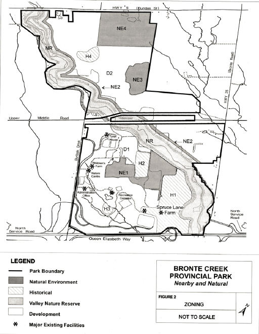
5.2.2 Natural environment zones (NE)
Four natural environment zones have been identified in Bronte Creek Provincial Park. Where possible, the zoning of land in the natural environment zone will provide for a buffer between areas of development and protection. Human intervention may occur in the management of the environment to support low intensity recreation and high quality educational opportunities.
NE1: Maple Sugar Wood lot
This zone covers an area of 34.9 hectares and is located in the south portion of the park. It includes an upland woodlot adjacent to areas containing planted trees and naturally regenerating fields. Old fields, pastures and orchards help to form a linkage between this woodlot and the forested creek valley.
Low intensity activities of educational value such as maple syrup demonstrations may be developed. Management of the demonstration woodlot may occur but activities will rely on traditional methods, such as drawing logs with horses, to assist with this management. The current internal road running through this zone will continue to exist. No road expansion will be permitted.
NE2: Table lands
Providing a direct buffer to the development zone located to the east, a natural environment zone with an area of 10 hectares runs the length of the eastern boundary of the Valley Nature Reserve and extends 20 metres from the edge of the Nature Reserve. This upland site supports mixed planted trees, abandoned orchards and naturally regenerating old fields and meadows.
Consistent with natural environment zoning, low intensity activities may be permitted and managed to supply high quality recreational experiences reflective of those which are experienced in other Ontario Parks. These may include back country style camping, equestrian and hiking trails, and research partnerships.
NE3: Back Country Woodlot
The Back Country Woodlot covers a 14.9 hectare area on the eastern edge of the park. This undisturbed woodlot is an oak hickory stand. Management may be undertaken to ensure its health is maintained.
Ten rustic cabins are proposed to be located on the western edge of this zone and five furnished permanent tents on its northern boundary. Vehicle access will not be permitted into this zone. Existing equestrian trails will be relocated within the zone to eliminate the traversing of wet areas and will be maintained to reduce impact and to provide a quality experience for the users.
NE4: Restoration area
The Restoration Area zone, 47.7 hectare in size, is located to the east of the Tremaine Road allowance. It will be established for the purposes of restoration of native species in a natural setting and the scientific monitoring of their health. The land is presently managed for agricultural use. Built facilities to support ongoing research can be accommodated.
Development will be limited to trails and associated signs. Activities that provide for education, whether it be in the form of research or interpretation, are encouraged. No equestrian trails will be located in this zone. Vegetative management will be undertaken to ensure that species health and vitality are maintained. Use of fire as a prescription for ecosystem health may be utilized.
5.2.3 Historical zones (H)
These zones focus on specific historic sites and in some cases the relationship of surrounding landscapes to the feature. Active partnerships supporting research, design and delivery of interpretive programs may be forged to enhance public understanding and appreciation of these significant cultural resources.
Hi: Spruce Lane Farm
Spruce Lane Farm Historical zone is located in the southern portion of the park. It is 45.8 hectares and includes historically accurate buildings and an agricultural land base. The farm is managed to recreate a late 19th century experience complete with livestock. Management undertaken in this zone will commonly use equipment and techniques true to the time period represented, but in special circumstances modern machinery may be used based on practicality. These buildings will continue to be maintained with historical accuracy.
The facility located on the western edge of the zone will be stabilized and will have its facade restored to as close to its original condition as possible. The interior may be modified to accommodate a possible future non-historical use (to be assessed and determined) which complements the objectives of the park. As identified through historic reviews, other structures associated with this site may be reconstructed. Landscaping will conform to standards of historical authenticity.
Activities of heritage education value will be encouraged and may involve demonstration areas and facilities, alternate accommodations such as elder hostels and a market place. Existing walking trails and areas for picnicking will continue to be available.
H2: Heritage Orchards
The Heritage Orchards site (8.4 hectares) consists of vineyards, and a living museum of trees representing the popular 19 century practice of growing apples and other types of fruit. This site recognizes the importance of past agricultural practices and land use. Restoration of the orchards may be undertaken and partners sought to enable the orchards and vineyards to be managed productively.
H3: Dig South (2.5 hectares)
H4: Dig North (6.5 hectares)
The South and North Dig zones are provincially significant archaeological sites. Qualified, licensed individuals or certified agencies and educational institutions will be encouraged to undertake further research to increase the understanding and awareness of the archeological values. Educational programs that are nondestructive could develop as a result of research.
5.2.4 Development zones (D)
Development zones are areas where either existing high quality recreational development occurs, or the establishment of proposed activities to assist in the achievement of the goal and objectives of the park can occur.
D1: Oasis
The Oasis zone is the area of the park with existing developments. This 175 hectare zone will continue to be for many the essence of what Bronte Creek Provincial Park offers. Continuation of the major activity centers such as the recreation complex, the children’s farm and the formal/informal picnic areas are proposed, as well as the development of facilities such as trails and parking in support of increased recreation activities. The park maintenance facilities will continue to be used and function in their present capacity.
The following are proposed for development:
- additional picnic shelters and sanitation facilities, as demand and carrying capacity warrants
- an Amphitheater north of the existing recreation complex
- a lookout tower on top of hill, and associated "fire in the ecosystem" theme activities and education opportunities
- a comfort station to service the Amphitheater
- a Welcome Centre at the Burloak Drive entrance
D2: Gateway
The Gateway zone is located on the north side of the Bronte Creek. This 165.1 hectare zone will serve to strengthen Bronte Creek’s role as a Gateway to Ontario’s provincial parks. Through active management it will allow for increased protection of the other values north of the creek.
The followinq are proposed for development:
- campgrounds that encompass a broad range of camping opportunities which can be experienced in other provincial parks. It is proposed to establish 400 sites concentrated in the centre of the zone. The development of these campsites will be phased in over a period of time
- tour group camp areas on the eastern section of the zone to the north of Upper Middle Road
- a Camping Learning Centre to serve as an introduction to all camping experiences offered in the park
- sanitation facilities to support camping activities
- a visitor registration center and an Ontario Parks Store
- a Fishing Centre west of the Tremaine Road allowance. The thrust of this development will be educating, informing and providing access to fishing opportunities. This will require modification of the existing ponds
- a Natural History Museum and a Trails Centre, south of Upper Middle Road. This development will include an equestrian trail head and linkages to trails within the park
- a road system to tie in to these major activities, with appropriate numbers of parking spaces
Buffers may be designed at strategic points along the perimeter of the park, between parkland and adjacent landowners, during the preparation of site plans. The design of buffers will take into consideration aesthetics, economics, proposed use, adjacent land use and environmental alteration.
6.0 Managing the resources
The park will be managed in accordance with Ontario Provincial Parks: Planning and Management Policies.
Within the framework of these policies, park specific direction will be developed at the park level for management strategies to be applied throughout the park. Where appropriate, site specific management strategies will be applied at particular locations. Monitoring, a more passive management activity, and the updating and maintenance of baseline information is required to determine the existing conditions in the park and to monitor changes and/or the success of a management strategy.
Table 2 identifies the management strategies to be applied to the park as a whole and within specific zones. Implementation of these strategies should be undertaken in partnership with naturalist groups, conservation authorities, municipalities and others interested in conservation and enhancement.
7.0 Operations strategy- Achieving the goal
Operations at Bronte Creek Provincial Park will be directed by a park operations strategy. This will provide park staff with the necessary direction required to operate the park on a day to day basis. In addition to addressing the following operations policies, the operations strategies will include the local business plan, maintenance schedules, enforcement and emergency services. The operations strategy will be consistent with the approved Ontario Provincial Parks Minimum Operating Standards, and will be reviewed annually and updated as required.
7.1 Natural heritage education
The natural heritage education program will provide visitors with the opportunity to gain an understanding, awareness and appreciation for the natural, cultural and recreational features of the park, and the Provincial Parks system. Bronte Creek will continue to deliver the natural heritage education program as a major activity. While existing programming will continue, emphasis will be placed on moving visitors beyond these opportunities by having them experience activities that can be enjoyed across Ontario’s provincial parks.
A natural heritage education strategy will be produced to guide the development and subsequent delivery of visitor information, heritage appreciation and recreational programming. This strategy will also direct activities and relationships with groups, agencies and organizations in the communities and region. Bronte Creek will be an active partner.
High quality, multi-media information materials will be prepared to enhance the quality of park visits, and be more available externally to increase the awareness of the park.
Table 2: Resource management strategies
Park Level - Vegetation management strategy
| Actions Natural Resource Management |
Nature Reserve Zone | Natural Environment Zones | Development Zones | Historical Zones |
|---|---|---|---|---|
| Review mowing frequency and area mowed | ✓ | ✓ | ||
| Control access to natural areas | ✓ | ✓ | ✓ | |
| Maintain trails | ✓ | ✓ | ✓ | ✓ |
| Revegetate areas of bare soil | ✓ | ✓ | ✓ | |
| Use native species for replanting | ✓ | ✓ | ✓ | |
| Reduce use of fertilizers and chemicals | ✓ | ✓ | ✓ | |
| Remove dead or fallen trees that may pose a safety hazard | ✓ | ✓ | ||
| Remove diseased vegetation | ✓ | ✓ | ||
| Control invasive species (i.e. garlic mustard) and noxious weeds (i.e. poison ivy) | ✓ | ✓ | ✓ |
Park Level - Aquatic Management Strategy
| Actions Natural Resource Management |
Nature Reserve Zone | Natural Environment Zones | Development Zones | Historical Zones |
|---|---|---|---|---|
| Identify and address deleterious inputs to watercourses | ✓ | ✓ | ✓ | ✓ |
| Install appropriate sediment and erosion control measures | ✓ | ✓ | ||
| Evaluate upstream/off-site impacts | ✓ | ✓ | ✓ | ✓ |
| Identify bank erosion sites |
Park Level - Other
| Actions Natural Resource Management |
Nature Reserve Zone | Natural Environment Zones | Development Zones | Historical Zones |
|---|---|---|---|---|
| Implement computerized database for maintaining records | G.I.S. | G.I.S. | G.I.S. | G.I.S. |
Monitoring - Vegetation Management Strategy
| Actions Natural Resource Management |
Nature Reserve Zone | Natural Environment Zones | Development Zones | Historical Zones |
|---|---|---|---|---|
| Monitor any management activities (i.e. plantings, trail closure) | ✓ | ✓ | ✓ | ✓ |
| Monitor significant species (i.e. population dynamics) | ✓ | ✓ | ✓ | |
| Prescribe burning to regenerate prairie | ✓ | ✓ |
Monitoring - Wildlife Management Strategy
| Actions Natural Resource Management |
Nature Reserve Zone | Natural Environment Zones | Development Zones | Historical Zones |
|---|---|---|---|---|
| Monitor significant species which are known to the park | ✓ | ✓ |
Aquatic Management Strategy
| Actions Natural Resource Management |
Nature Reserve Zone | Natural Environment Zones | Development Zones | Historical Zones |
|---|---|---|---|---|
| Monitor fish community, benthic community | ✓ |
Site Specific - Erosion Control strategy
| Actions Natural Resource Management |
Nature Reserve Zone | Natural Environment Zones | Development Zones | Historical Zones |
|---|---|---|---|---|
| Implement bank stabilization measures | ✓ | ✓ | ||
| Implement bioengineering techniques | ✓ | ✓ |
Site Specific - Vegetation Management Strategy
| Actions Natural Resource Management |
Nature Reserve Zone | Natural Environment Zones | Development Zones | Historical Zones |
|---|---|---|---|---|
| Evaluate demonstration woodlot program | ✓ | |||
| Encourage vegetated linkages between natural areas for wildlife movement | ✓ | ✓ | ✓ | ✓ |
| Tree planting | ✓ | ✓ | ✓ | ✓ |
| Restoration of old fields | ✓ | ✓ | ✓ | |
| Examine feasibility of returning crops fields to natural state | ✓ | ✓ | ✓ | |
| Undertake trail management plan - close and revegetate unused, unauthorized trails | ✓ | ✓ | ✓ | ✓ |
| Assess disturbance of natural and protected areas (i.e. unauthorized trails, structures, cutting for firewood, etc.) | ✓ | ✓ | ✓ |
Site Specific - Aquatic Management Strategy
| Actions Natural Resource Management |
Nature Reserve Zone | Natural Environment Zones | Development Zones | Historical Zones |
|---|---|---|---|---|
| Remove barriers to fish movement | ✓ | |||
| Use bioengineering techniques to stabilize sites of bank instability and erosion | ✓ | |||
| Construct authorized access points to watercourse to focus use | ✓ | ✓ |
Update Baseline Information - Vegetation Management Strategy
| Actions Natural Resource Management |
Nature Reserve Zone | Natural Environment Zones | Development Zones | Historical Zones |
|---|---|---|---|---|
| Update and verify plant communities | ✓ | ✓ | ||
| Update and verify locations of significant species | ✓ | ✓ | ✓ | ✓ |
| Develop management plans for significant species | ✓ | ✓ | ||
| Develop prairie habitat management plan | ✓ | ✓ |
Update Baseline Information - Wildlife Management Strategy
| Actions Natural Resource Management |
Nature Reserve Zone | Natural Environment Zones | Development Zones | Historical Zones |
|---|---|---|---|---|
| Update surveys of breeding birds, mammals, reptiles and amphibians with emphasis on significant species known from historical records (i.e. wood turtle) | ✓ | ✓ | ✓ | ✓ |
Update Baseline Information - Aquatic Management Strategy
| Actions Natural Resource Management |
Nature Reserve Zone | Natural Environment Zones | Development Zones | Historical Zones |
|---|---|---|---|---|
| Habitat mapping, electrofishing surveys, benthic invertebrate community characterization | ✓ | |||
| Pond studies | ✓ | ✓ | ✓ | ✓ |
| Riparian vegetation management studies | ✓ | |||
| Map seepage zones | ✓ |
Update Baseline Information - Cultural Management Strategy
| Actions Natural Resource Management |
Nature Reserve Zone | Natural Environment Zones | Development Zones | Historical Zones |
|---|---|---|---|---|
| Linkage with heritage groups, the preservation and presentation of buildings and land use practices, and archaeological research | ✓ | |||
| Prepare a building audit of observed problems e.g. brick and masonry problems, foundations | ✓ | |||
| Provide heritage conservation training to ensure appropriate interventions | ✓ | |||
| Establish a program of preventative maintenance, repair and planned renewal | ✓ | |||
| Apply existing computer database to track conditions, interventions and schedule for each structure and task | ✓ |
Informal and formal recreational programs will be provided to encourage visitors to participate in Bronte Creek’s oasis activities as well as gateway experiences to be found throughout Ontario’s provincial parks. Seasonal recreation activities in the Recreation Complex area will reflect recreation opportunities throughout the park system and respect the cultural activities of park visitors.
Interpretation will focus on the existing themes of natural and cultural education specific to:
- the Valley Nature Reserve, including earth and life science features, and native cultural use
- Spruce Lane Farm and associated lands depicting rural life in the early 1900's
- nearby and natural features of Southern Ontario
- Ontario Provincial Parks
The strategy will further address new themes developing from the management plan, such as outdoor and camping skills.
Growth in evening programming, with the intent to complement existing day use opportunities and school group use, will be a priority in program development.
7.2 Research and monitoring
Scientific research and monitoring by qualified groups and individuals will be encouraged to provide a greater understanding of natural and cultural values and resources of the park. Research that may be used to enhance the operations of the park and to evaluate the suitability of ongoing programs will also be encouraged. All research initiatives will be approved and subject to review by Ontario Parks.
7.3 Recreation management
Bronte Creek Provincial Park will continue to provide high quality year round day use recreational experiences such as family and group picnicking, swimming, trail use, play areas and summer and winter sports or activities. Further, this plan enables the park to address the need for camping opportunities, through the provision of the range of experiences a visitor can encounter within the system of provincial parks.
Recreational activities that complement the park goal, objectives and user needs will be considered if they do not conflict with zoning and the Ontario Provincial Parks: Planning and Management Policies.
Equestrian use will be managed in the north section of the park. Use of all-terrain vehicles will not be permitted within the park.
7.4 Marketing and partnerships
A marketing strategy will be prepared to attract visitors during low use periods; to increase involvement with the commercial sector by encouraging park users to take advantage of local services and attractions; and to stimulate positive interactions with the tourist and commercial operators in the area. This strategy will be reviewed periodically.
General park promotion will form part of the marketing strategy. Promotion will be undertaken to inform neighbouring communities about the range of park services and programs and to encourage existing park users to explore other areas within the park. Park signage and promotional material will emphasize Bronte Creek’s role as a gateway to Ontario’s provincial park system.
Emphasis will be given to developing partnerships for items such as capital development projects, interpretive efforts, research, co-management, trail development and other activities.
Successful park operations will also require a high degree of cooperation with other agencies and sectors. This management plan encourages continued dialogue on matters including but not be limited to the following:
- monitoring neighbouring community and visitor concerns for the park
- promoting area businesses offering services compatible with park objectives
- assisting in developing heritage appreciation programs
- using volunteers in laying out and maintaining trail systems
- monitoring tourism potentials
- solving problems with new ideas
Cooperation, communications and partnerships with Bronte Creek’s many client and interest groups is key to the implementation of any component of the operations strategy.
8.0 Development principles
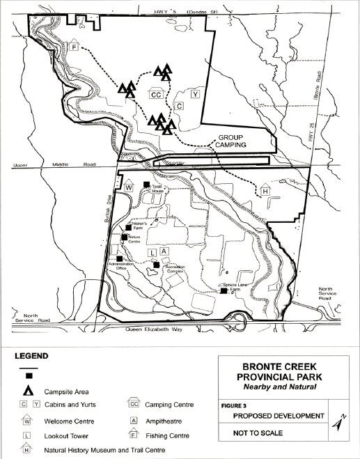
There are a number of facilities that require upgrading to achieve the objectives for Bronte Creek Provincial Park. These include the existing houses used for programs and administration purposes: Medland Farmhouse (Nature Centre); Henry C. Breckon Farmhouse (Spruce Lane Farmhouse); Fred Breckon Farmhouse (Silverbrook Farm); and the Burkholder Farmhouse (Park Office). A listing of suggested development projects is found in Section 10.0 and shown in Figure 3.
Detailed site plans and development plans will be prepared prior to commencement of new development, restoration or upgrading of existing facilities. The requirements of the Environmental Assessment Act will be followed.
9.0 Implementation strategy
The management plan will be revised in 20 years or as the need arises. Any major amendments to this plan will require public consultation. Data collection and environmental monitoring will be conducted as required. The day to day operations of the park will be guided by the park operating strategy. Projects may be undertaken as funds are available. Partnerships with other organizations will be encouraged to the extent that they support the goal and objectives of the park.
Future requirements identified in this plan include:
- internal valley bridge crossing;
- backcountry – style camping opportunities, roofed accommodations such as rustic cabins, furnished tents and walk-in campsites
- trails including equestrian trailhead
- Welcome Centre
- Amphitheatre and sanitation facilities
- lookout tower
- campgrounds (400 campsites) and sanitation facilities
- Fishing Centre
- Camping Learning Centre
- Natural History Museum and Trail Centre
- support roads and parking
Figure 3: Proposed Development
10.0 Delivering the vision
Eight key facilities are suggested to make the park vision of Gateway, Oasis and Linkage a reality. These are described below.
This plan departs from traditional management plans in that it proposes a range of acceptable facilities and services that could be carried forward separately or in combination to achieve the park goal. It is not proposed that all facilities would necessarily be developed. Instead, this plan provides flexibility and latitude for park managers to meet the needs of their clients and align with partners who will work with them to enhance the core business of the Provincial Parks system —protection, education, recreation and tourism.
The following should be reviewed as a list of seeds to grow services and facilities for Bronte Creek Provincial Park.
10.1 Welcome Centre
A Welcome Centre can provide an orientation to Bronte Creek Provincial Park, the provincial parks system and the region. The centre could include a conference centre, an Ontario landscape gallery, a theatre, a suite of computer terminals, a restaurant and washrooms. Visitors could be encouraged to come to the Welcome Centre as they enter the park. There, they could learn about the facilities and programs at Bronte Creek as well as experience and learn about provincial parks across Ontario. An IMAX theatre, virtual reality rooms and computer terminals could provide different ways to experience the many attractions of Ontario provincial parks These range from wolf howls and wild rivers to canoeing and polar bears.
A shuttle service and bicycle rental could be provided to move visitors out to other parts of the park.
The Welcome Centre might also act as a meeting place for Ontario environmental nongovernment agencies by offering shared administrative services under one roof.
The Welcome Centre can act as:
- a gateway to Bronte Creek Provincial Park, other Provincial Parks and the Region
- an oasis of nature and the natural environment in an urbanizing community
- a link to nature and the community
10.2 Education Centre
The Education Centre at Bronte Creek Provincial Park can provide a learning place for visitors of all ages. It could be a place to learn about endangered species and protection, loss of habitat, birds of prey, farming (past, present and future) and heritage breeds. Virtual reality rooms, computer programs, lectures and hands-on displays and demonstrations could act as learning tools. The Education Centre could continue with the interactive learning approach of the baby animals in the farm context.
The Education Centre could also offer a place to learn about completed, ongoing and future research. It may also offer an opportunity for use as a research facility.
The Education Centre can act as:
- a gateway to learning about wildlife in other parts of Ontario and Canada
- an oasis of wildlife education in an urbanizing community
- a link to other education centres
10.3 Spruce Lane Gathering Area
The Spruce Lane Gathering Area is based on its heritage, as well as its agricultural and demonstrations appeal. Spruce Lane could include expanded lecture and demonstration facilities. Lectures could include wine making, apiculture, organic gardening, food preserving, candle making and maple syrup production. Activities at Spruce Lane could be organized seasonally with a focus on holidays and harvest times.
The Spruce Lane Gathering Area could offer attractions and activities for all ages and groups. Elder Hostels could hold special attraction for seniors while maple syrup production and related activities could appeal to the entire family.
A farmers market with local produce and crafts could provide visitors with both practical and entertainment value.
The Spruce Lane Gathering Area can act as:
- a gateway to learning about heritage activities;
- an oasis of farm life in an urbanizing area;
- a link to past and present agricultural practices.
10.4 Stewardship Centre
The Stewardship Centre could provide an opportunity for visitors to learn about the stewardship in their own backyard and the larger world around them. A Stewardship Centre could offer a hands-on opportunity to learn about vegetable and flower gardening, wildflowers, composting and birding. The Centre could include a sales outlet for gardening supplies, garden areas for photo opportunities, a bugatorium, and learning exhibits. Programs and lectures could include the Junior Naturalist Program, woodlot management, composting and perennial gardening. Rental garden plots and perennial beds for walking tours could provide additional visitor activities.
The Stewardship Centre can act as:
- a gateway to learning about your backyard
- an oasis of "green" and "growing" in an urbanizing area
- a link to issues of environmental sustainability and ecosystem health
10.5 Natural History Museum and Trail Head
The Natural History Museum could be dedicated to the conservation, preservation, research and display of vertebrate life. The Natural History Museum can showcase the natural history and the evolution of life in Ontario, as well as be an overview of provincial parks. The Trail Head provides an orientation to the trails at Bronte Creek Provincial Park, within other provincial parks and the region. The Trail Head could include facilities for hikers, cyclists, equestrian route planning, provincial trail information and map sales. It might also serve as a centre for courses, lectures and programs such as orienteering. It could serve as a trail staging area for equestrian use and access into the park.
The Natural History Museum and Trail Head can act as:
- a gateway to the natural history and to the trails at Bronte Creek Provincial Park and to other provincial parks
- an oasis of nature
- a link to the past and to local, regional and provincial trails
10.6 Sports and Recreation Centre
The Sports and Recreation Centre can provide visitors with a variety of leisure, art and sport activities. The Centre could include a grassed amphitheater, beach volleyball courts, roller blading area, skating, and swimming. Courses and programs could relate to canoe and water safety, bicycle rodeos and first aid. The Centre could offer visitors an opportunity to relax, learn and play.
The Sports and Recreation Centre can act as:
- a gateway to other recreational experiences at other provincial parks
- an oasis of sun and fun
- a link to safety training for more enjoyable recreational use
10.7 Camping Centre
The Camping Centre could provide a range of camping experience — conventional tents, recreational vehicles, and furnished tents. The Camping Centre could include provided camping facilities, visitor services, youth campgrounds, and group campgrounds. It could provide a learning opportunity as well as the opportunity to camp close to local area attractions. It might also act as a meeting place for a Junior Ranger program.
The Camping Centre can act as:
- a gateway to the range of camping experiences in Ontario provincial parks
- an oasis of nature
- a link to other provincial parks camping opportunities
10.8 Fishing Centre
The Fishing Centre could be geared to a variety of visitors interested in fishing. It could act as a focal point for fishing in provincial parks and elsewhere. It could offer top-notch information on fish habitat and protection, fish identification and basic guidance and instruction. Experts could be invited to lead demonstrations, give lectures and import knowledge on fishing. Fishing licenses and a fishing supply sales outlet could be available here.
The Fishing Centre will act as:
- a gateway to fishing in Ontario provincial parks
- an oasis for the beginning angler
- a link to Twelve Mile Creek and Lake Ontario
11.0 References
Geomatics International Inc. 1993. Environmentally Sensitive Area Study. Geomatics International Inc. Guelph, Ontario.
House, L. and D. Carleton. 1988. Life Science Inventory of Bronte Creek Provincial Park. Ontario Ministry of Natural Resources, Open File Ecological Report 8801.
Lindsay, K.M. and D. Carleton. 1979. Ontario Nature Reserve Program - Life Science Inventory Check Sheet - Bronte Creek Provincial Park. Ontario Ministry of Natural Resources, Division of Parks, Park Planning Branch. Toronto, Ontario.
MacDonald, I.D. and Schreiber, M. 1973. Life Science Inventory Check List. Ontario Ministry of Natural Resources - Environmental Planning - Parks Planning Branch. Toronto, Ontario.
Ministry of Natural Resources. 1987. Cambridge District Fisheries Management Plan: Background Information and Ootional Management Strategies - 1987 - 2000. Ontario Ministry of Natural Resources. Toronto, Ontario.
Ministry of Natural Resources. 1988. Bronte Creek Provincial Park Management Review -Background Information and Issues and Options. Ministry of Natural Resources.
Ministry of Natural Resources. 1988. Bronte Creek Provincial Park Fact Sheet - Draft Management Plan. November, 1988. Ministry of Natural Resources.
Ministry of Natural Resources. 1988. Bronte Creek Provincial Park Draft Revised Management Plan. Ministry of Natural Resources.
Ministry of Natural Resources. 1990. Bronte Creek Provincial Park Management Plan. Parks and Recreational Areas Branch, Central Region, Ministry of Natural Resources.
Ministry of Natural Resources. 1992. Ontario Provincial Parks: Planning and Management Policies. Provincial Parks and Natural Heritage Policy Branch, Toronto, Ontario.
Ministry of Natural Resources. 1992. Ontario Provincial Parks Minimum Operating Standards. Provincial Parks and Natural Heritage Policy Branch, Toronto, Ontario.
Ministry of Natural Resources. 1995. Bronte Creek Provincial Park Brochure. Ministry of Natural Resources.
Ministry of Natural Resources. 1996. Bronte Creek Provincial Park Information Guide. Winter/Spring 1996-1997. Ministry of Natural Resources.
Ministry of Natural Resources. 1996. Ontario Parks Business Plan Summary. Ontario Parks, Ministry of Natural Resources.
Ministry of Natural Resources. 1996. Bronte Creek Provincial Park Information Guide. 1996 Spring/Summer. Ministry of Natural Resources.
Ministry of Natural Resources. 1997. Nearby and Natural. Ontario Parks Guide 1997. Ontario Parks, Ministry of Natural Resources.
Portt, C. 1981. An Assessment of the Bronte Creek Watershed with Recommendations for Salmonid Management. Ministry of Natural Resources - Cambridge District.
Regional Municipality of Halton. 1997. Research Paper 9702: Best Planning Estimates of Population and Occupancy Dwelling Units, 1997-2016. Regional Municipality of Halton.
Woerns, N. 1977. Bronte Creek Provincial Park Earth Science Inventory Checklist. Ontario Ministry of Natural Resources, Division of Parks, Parks Planning Branch, Toronto, Ontario.
Appendix A: Consultation
Consultation was the cornerstone of the review process for Bronte Creek Provincial Park’s Management Plan.
The process was formally announced in the newspapers in May 1997 and the public was invited to participate and to become involved in the review. The process was initiated with workshops held in June 1997 attended by present and retired Ontario Parks staff, university, business, naturalists, local municipalities, conservation authorities, and volunteer and community interests. The Gateway, Oasis and Linkage concepts evolved during these sessions. In addition, surveys were sent to individuals and groups booking services and facilities in the park to identify their needs.
In July, 1997, the consultants met with park users and staff, and held a one day Drop-In Center. Approximately 250 people attended this session. Participants spoke highly of the park and many like it the way it is. No one took objection to pursuing the concepts of the Gateway, Oasis and Linkage. Most focused their comments to what they liked about one or all three concepts. Many spoke in favour of the idea of camping, fishing, an expanded welcome centre and trails.
Seventy people attended an Open House on October 29, 1997 to discuss the draft plan, and fiftyseven letters and completed comment sheets were received. Thirty percent of the respondents specifically identified their support for a foot bridge and 19 percent specifically identified the need for camping. Opposition was expressed by a few respondents to a proposed name change to the park and the number of proposed campsites. The management plan was revised based on these comments.
Seeking direction briefing note
Division: Natural Resources Management Unit
Branch: Ontario Parks, Southwest Zone
Riding: Oakville - Gary Carr, MPP (PC)
Significant Dates: N/A
Issue: Minor Amendment to the Bronte Creek Provincial Park Management Plan And Minor Boundary Amendment and Disposition of Land
Background:
Bronte Creek is a recreation class provincial park located within the Regional Municipality of Halton immediately north of the Queen Elizabeth Highway on the City of Burlington and Town of Oakville Boundary. The 682.8 hectare provincial park features a provincially significant Life Science Area of Natural and Scientific Interest (ANSI) and a regionally significant Earth Science ANSI. The park was first regulated in 1975 under the Provincial Parks Act, with subsequent park boundary amendments as depicted in the following table.
| Year | Ontario Regulation | Area (ha.) | Comments |
|---|---|---|---|
| 1975 | (O. Reg. 661/75) | 640.83 | Initial regulation of park |
| 1979 | (O. Reg. 151/79) | 639.57 | 1.26 ha. deleted from park boundary |
| 1980 | (O. Reg. 821/80) | 639.57 | Correction to boundary description |
| 2001 | (O. Reg. 382/01) | 682.80 | 43.23 ha. of acquired lands regulated |
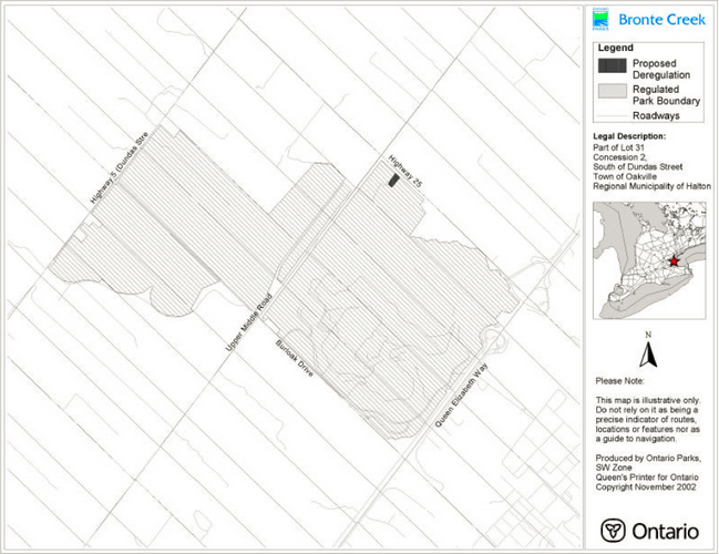
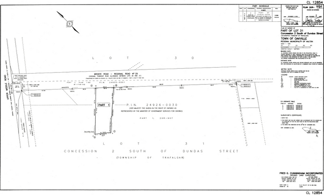
A 0.556 hectare parcel fronting on Bronte Road (Halton County Road 25) was declared surplus to the needs of Ontario Parks and the Ministry of Natural Resources in 2002 and is recommended to be deregulated from the park. This would reduce the total park area to 682.234 hectares (a decrease of only 0.08%). The parcel contains a residence and detached garage. The residence is currently vacant but was rented out to a local not-for-profit agency up until 2001. The Ontario Realty Corporation will undertake the disposition of the property upon deregulation. The parcel is shown on the attached maps and is described more particularly as follows:
| Legal Description | Instrument | Reference Plan | Acreage | Former Owner | Purchase Price | Purchase Date |
|---|---|---|---|---|---|---|
| Part Lot 31, Concession 2, South of Dundas Street (SDS),Geographic Township of Trafalgar, Town of Oakville, Regional Municipality of Halton | 834316 | Part 1 of Reference Plan 20R- 14904 |
0.566 ha. | Maridun Delmac Holdings Limited | $2.00 | January 31, 1995 |
As per Ontario Parks policy PM 11.01, "Amending and Rescinding Park Boundaries" (1993), this deletion is considered a minor boundary amendment. This proposed minor boundary amendment is characterized as follows:
- minor, if any, impacts on park values as this parcel is well outside the provincially significant Life Science Area of Natural and Scientific Interest and no significant species or habitats have been identified on or immediately adjacent to this parcel in either the Life Science Inventory of Bronte Creek Provincial Park (L. House and D. Carleton, 1988) or in the current Natural Heritage Information Centre database
- minimal changes in the land or resource management practices inside or outside of the park as the residence and garage are not required for park programs (the buildings present a potential liability and would require a large capital investment to be brought up to Ontario Building Code standards
- little public reaction is anticipated and there were no negative comments received as a result of local public consultation efforts (on-site notice, paid advertisement, and mailings to adjacent property owners)
Approval of this decision note will also constitute a minor amendment to the Bronte Creek Provincial Park Management Plan (1998).
This minor boundary amendment and is permitted by sub-section 3(2) of the Provincial Parks Act which states, "The Lieutenant Governor in Council may set apart as a provincial park any area in Ontario, may increase of decrease the area of any provincial park and may delimit any provincial park."
Since the boundary amendment requires an amendment to the regulations under the Provincial Parks Act, Ontario Parks will post an Environmental Bill of Rights "regulation proposal notice" on the Environmental Registry for public comment for a minimum period of 45 days in advance of processing the regulation.
Subject to condition 6 of Exemption Order MNR-59/2 made under the Environmental Assessment Act, Ontario Parks will notified on May 16, 2002, individually, landowners adjacent to the property being recommended to be deleted from the boundary regulation for Bronte Creek Provincial Park. That notification was in the form of a mailed notice.
A newspaper advertisement was posted in the Burlington Post and Oakville Beaver on May 22, 2002 and a notice was posted on the property in question for 45 days commencing on March 11, 2002 notifying the public of Ontario Parks' intent to declare the property surplus to its needs and to have it deregulated for the purpose of amending the boundary regulation for Bronte Creek Provincial Park.
Recommended option:
It is recommended that this minor amendment to the Bronte Creek Provincial Park Management Plan be approved, and further, that the park boundary be amended to deregulate the subject property and thereafter have the property disposed of by the Ontario Realty Corporation.
Approvals
Issues: Minor Amendment to the Bronte Creek Provincial Park Management Plan and Minor Boundary Amendment and Disposition of Land
Dave Boddington
Park Superintendent
Bronte Creek Provincial Park
Date: March 18, 2003
Tracy Smith
District Manager
Aurora District, MNR
Date: March 27, 2003
Peter Sturdy
Zone Manager
SW Zone, Ontario Parks
Date: March 19, 2003
Adair Ireland-Smith
Managing Director
Ontario Parks
Date: June 25, 2003
Figure 4: Bronte Creek Provincial Park Proposed Deregulation
Enlarge Figure 4: Bronte Creek Provincial Park Proposed Deregulation
Figure 5: Survey of Bronte Creek Provincial Park Proposed Deregulation
Enlarge Figure 5: Survey of Bronte Creek Provincial Park Proposed Deregulation