Bruce Lake Conservation Reserve Management Statement
This document provides policy direction for the protection, development and management of the Bruce Lake Conservation Reserve and its resources.
Statement of Conservation Reserve
Prepared for OMNR, Red Lake District
Updated November 2011
Clare Mitchell
OLL Intern
Approval statement
I am pleased to upprove this Statement of Conservation Interest for the Bruce Lake Conservation Reserve.
This statement of Conservation Interest provides guidance for the management of the Conservation Reserve and the basis for the ongoing monitoring activities. Should significant facility development or resource management be considered, or complex issues arise requiring additional studies, a more detailed Conservation Reserve Management Plan will be prepared with full public consultation.
The public was widely consulted during the original regulation process for this site in July of 2000 and First Nation’s consultation was completed with Treaty 3 in May of 2001. No further consultation is required at this time.
The Bruce Lake conservation Reserve will continue to be managed by the Red Lake South area Office of Red Lake District, Ontario Ministry of Natural Resources.
Signed by:
Graeme Swanwick
District Manager
Red Lake District
Date: July 19, 2001
Signed by:
Charlie Lauer
Regional Director
Northwest Region
Date: August 8, 2001
1.0 Background information
The purpose of this document is to identify the natural heritage values of the Bruce Lake Conservation Reserve, as well as identifying the type and extent of current recreational use on-site. A set of management guidelines defines the activities that will and will not be permitted, as well as the overall management direction for the area. For more information on the basis for this Statement of Conservation Interest, please refer to the "Conservation Reserves Policy and Procedure" PL3.03.05.
| Name | Bruce Lake Conservation Reserve |
|---|---|
| Ecoregion/Ecodistrict | 3S/3S-5 |
| OMNR administrative region/District/Area | Northwest Region - Red Lake District, Red Lake South Area |
| Total area (ha) | 5435 ha and 252 ha of Forest Reserve |
| Regulation date | Pending |
| First Nations | N/A |
| Latitude/Longitude | 50°49', 93°15' |
| Basemaps | 47562, 47563, 48562, 48563 |
| Forest Resource Inventory Stands | 401, 407, 412, 419, 423, 426, 660, 667. Among others. (FRI 1977). New inventory expected by 2001 from Weyerhaeuser Canada. The Forest Resource Inventory was updated in 1996. |
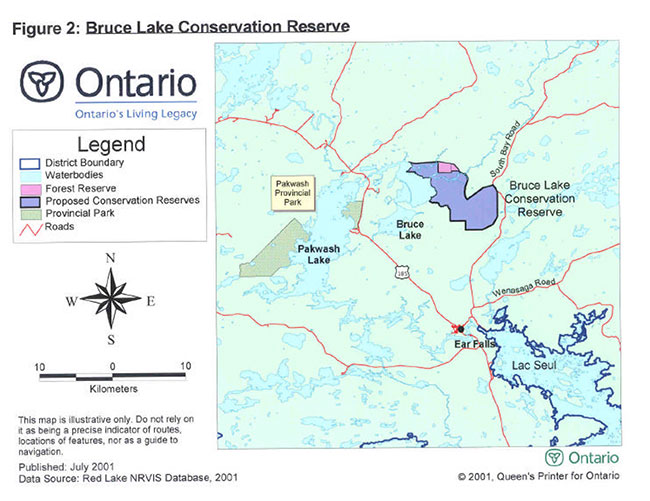
| General location description | Located approximately 25 km north of Ear Falls and east of Pakwash Provincial Park. |
| Access | The Conservation Reserve can be reached via tertiary roads connecting to Highway 105. |
1.1 Targets
This section provides a summary of the earth science, life science, and cultural resource values as well as present or possible recreational opportunities.
| Life science representation |
The site is characterized by open bogs, fens and emergent Marshes, as well as swamps which are dominated by mature Coniferous vegetation. Along the Southern shore of Bruce Lake burns have occurred within the last 80 to 100 years. In the interior, burns have been estimated to have not occurred in over 160 years. 5 critical Landform/Vegetation associations in ecodistrict 3S-5. |
|---|---|
| Earth science representation | The site represents a diverse peatland developed on a weakly broken plain of lacustrine clay, till materials and terminal moraines. |
| Cultural resource representation | No documented cultural heritage values identified. |
| Recreational opportunities | Due to the remoteness of this site, access for recreational opportunities is limited. In the past this area has been used for hunting moose and small game. Recreational canoeing and angling occurs in the Trout Lake River and the adjacent Bruce Lake. |
1.2 Survey information
This section provides an overview of the inventories completed, type of survey (reconnaissance or detailed) and any further inventories that are needed.
| Survey level | Reconnaissance | Detailed | Requirement |
|---|---|---|---|
| Life Science | 2001 | N/A | Yes |
| Earth Science | 2001 | N/A | Yes |
| Cultural | No | N/A | No |
| Recreational | 2001 | N/A | Yes |
| Other | OGS Peatland Inventory Project (1979) |
2.0 Values to be protected
This section provides a description of the key natural heritage values on the site, and their condition relative to past resource use and management activities and their sensitivity to future land use management activities.
2.1 Values identified on the site
| Life science | This site contains features that are representative of peatland and is characterized by open bogs and fens. The dominant tree species is Black Spruce. |
|---|---|
| Earth science | Peatland developed on a weakly broken plain of lacustrine clay and till materials and terminal moraines |
| Cultural | None Identified |
| Aboriginal | None Identified |
| Tourism | None Identified |
| Recreational fishing | There is recreational fishing in the Trout Lake River and the adjacent Bruce Lake. |
| Recreational hunting | Site has been used by local residents for moose and small game hunting. |
| Mining aggregates | Low mineral potential on site, iron ore mining has occurred at the adjacent Griffith Mine. |
| Forest harvest | Low potential. |
| Trapping | Two licensed traplines in the site that are active (RL 73 and RL 23). |
| Bear Management Area | Part of three active Bear Management Area (RL-03-026, RL-03-032 and RL-03-033). |
| Commercial fish | Two Bait harvest areas within CR (blocks 507932 and 507931) – The Trout River provides the only harvest opportunity. |
2.2 Values to be protected
The intent of this Statement of Conservation Interest is to protect values by establishing management guidelines for existing and potential uses in this area, given the level of past disturbance and the nature of the existing features.
Forest Values: Since this site is dominated by peatlands there is a minimal amount of tree vegetation. The dominant tree species is Black Spruce (Picea mariana) although Speckled Alder (Alnus incana) and two types of Birch (Betula L.) are present. The trees are to be protected from future harvest operations.
A Forest Reserve (FR) containing active mining claims is located along a portion of the northern boundary of the Conservation Reserve. Forest Reserves are areas where protection of natural heritage and special landscapes is a priority, but some resource use can take place with appropriate conditions. Access to existing claims will be permitted through the conservation reserve where it can be demonstrated that no negative impacts will occur on these special features. A lapse in a claim or lease on the Forest Reserve will cause it to revert back to the Crown and it will be withdrawn from any future staking.
Species at Risk Values: The conservation reserve provides habitat to bald eagles, which have been confirmed in 2010. Bald Eagles are a species at risk under the Endangered Species Act (2007).
Recreational Values: The Conservation Reserve offers unofficial opportunities for summer and winter recreational activities. Sport fishing opportunities are available on Trout Lake River and in adjacent Bruce Lake. Trout Lake River is also a downstream tributary of Trout Lake and as such forms part of a canoe route.
Tourism Values: Due to the fragile nature of the peatlands on this site, the establishment of tourism opportunities would need to be carefully monitored. The site is accessible by tertiary roads off the South Bay Mine road and by boat through Bruce Lake. This site also offers potential for Eco-tourism opportunities.
3.0 Management guidelines
3.1 Land tenure
Bruce Lake Conservation Reserve will remain Crown Land. Existing dispositions such as the Ear Falls Ski Hill will be eligible for annual renewal and new dispositions will be at the discretion of the Red Lake South Area Supervisor. As outlined in the Conservation Reserve Policy (PL 3.03.05) commercial timber harvest, mining, hydroelectric power, peat and aggregate extraction will not be permitted.
3.2 Existing and proposed development
The former ski hill’s warm up shack (within the eastern boundary of the Conservation Reserve) is now being used as a trap cabin. At this time there are no proposed developments within the boundaries of the Conservation Reserve.
3.3 Recreational activities
Most recreational activities that have been traditionally enjoyed in this area can continue provided they present no threat to the natural ecosystems and features protected by the Conservation Reserve. These permitted uses include wildlife viewing, hunting, hiking, snowshoeing and cross-country skiing. Sport fishing, boating and canoeing will continue to be permitted in Trout Lake River and Bruce Lake.
3.4 Commercial activities
The Bruce Lake Conservation Reserve is part of the Trout Lake Forest and will be removed from the Sustainable Forest License (SFL) currently held by Weyerhaeuser Canada. An examination of the possible impact of activities on adjacent lands will be evaluated during the forest management planning process.
The Conservation Reserve has been withdrawn from all mineral exploration and extraction activities by the Ministry of Northern Development and Mines (MNDM).
The Bruce Lake Conservation Reserve contains part of two registered traplines (RL- 73 and RL-23) which are presently active and which will be permitted to continue. No trap cabins currently exist within the conservation reserve and new cabins will not be permitted.
The area is part of three Bear Management Areas, RL-03-026, RL-03-032 and RL- 03-033. Hunting will continue as a permitted use in this Conservation Reserve. No facilities within this CR are associated with this operation and no new structures will be permitted.
No other commercial activities exist in the area. No new activities, such as mining, aggregate or peat extraction, commercial logging, hydroelectric power development, utility corridors or roads, will be permitted.
Careful mineral exploration may occur in specific new conservation reserves proposed through Ontario Living Legacy Land Use Strategy, in areas that have provincially significant mineral potential. If a portion of the new conservation reserve is to be developed for a mine, it would be removed from the reserve, and appropriate replacement lands would be placed in regulation.
3.5 Aboriginal interests
The Conservation Reserve is part of Treaty 3 and includes some Lac Seul Band interests.
3.6 Natural resources stewardship
3.6.1 Vegetation management
The area will naturally evolve as a peatland and although this Conservation Reserve is excluded from the Trout Lake Forest landbase, it will remain part of the Intensive Fire Management Zone. For this reason fire occurrences will be considered a high priority for action. However, in order to maintain the ecological integrity of this site, the role of fire must be considered.
Flexibility in suppressing Low Risk fire occurrences within this Conservation Reserve should be evaluated where the opportunity presents itself. Prescribed fire should also be considered as a management tool, to emulate over time, the natural fire ecology of the area. However, intensive fire management and protection will continue to be carried out on this protected area until an alternative direction for the control of it is approved through a more detailed local natural resource plan or management plan.
3.6.2 Fish and wildlife management
Existing Wildlife Management Unit and sport fishing regulations and their management activities will apply to facilitate the management of fish and wildlife in this reserve.
3.6.3 Landforms
The protection afforded by the Conservation Reserve is sufficient at this time.
3.7 Cultural resources stewardship
No management activity is required at this time based on existing information.
3.8 Client services
Access to this site for recreational purposes will not be encouraged.
3.9 Research
Non-destructive research related to the study of peatlands will be encouraged and monitored in this conservation reserve.
3.10 Marketing
No management activity is required at this time.
4.0 Implementation
Implementation of these management guidelines is the responsibility of the Red Lake South Area, Red Lake District. Any affected clients will be immediately informed of proposed changes to this Statement of Conservation Interest.
5.0 Review and revisions
The Bruce Lake Conservation Reserve Statement of Conservation Interest will be reviewed on an ongoing basis.
In accordance with the Provincial Parks and Conservation Reserves Act (2006), MNR will examine management direction documents that have been in place for 10 years or more. The next scheduled review for Bruce Lake Conservation Reserve will be in 2020.
If changes in management direction are needed at any time, the significance of the changes will be evaluated. The need for public notice or more formal consultation will be assessed. Any major amendments will require full public consultation and the approval of the District Manager and Regional Director. This Statement of Conservation Interest complies with all the requirements of the Environmental Assessment Act and the Environmental Bill of Rights.
5.1 Public consultation
5.1.1 Results of past consultation
During the Lands for Life resource planning and public consultation process, which began in 1997, the opportunity was provided for all interested stakeholders to provide input on the proposed sites. On March 29, 1999, Premier Harris announced the establishment of Ontario’s Living Legacy - the most comprehensive, long-term program of natural heritage protection in the province’s history. As a result of this process, boundaries for the Bruce Lake Conservation Reserve were proposed. In August of 2000, another public consultation process was initiated to allow any further comments on the proposed boundaries
5.1.2 Present and future consultation
No issues arose from the extensive public consultation in August 2000. Further consultation with Treaty #3 and representatives of Lac Seul First Nation was carried out in April 2001. No boundary refinements were suggested for this site. Inquiries received were general in nature and pertained mostly to permitted uses within Conservation Reserves.
6.0 References
Ontario Ministry of Natural Resources. 1981. West Patricia Land Use Plan.
Ontario Ministry of Natural Resources. 1997. Conservation Reserves Policy and Procedure (PL 3.03.05).
Ontario Ministry of Natural Resources. 1999. Ontario’s Living Legacy - Land Use Strategy July.
Noble, T.W. (for the Ontario Ministry of Natural Resources). 1998. Site Region 3S Gap Analysis.
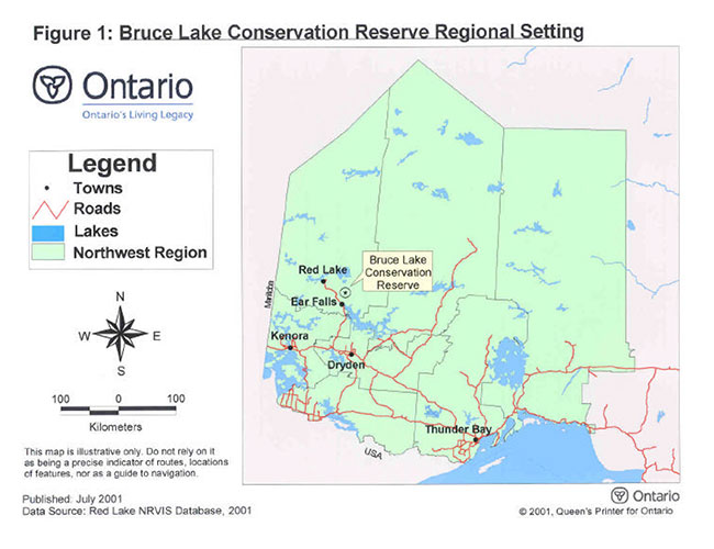
Figure 1: Bruce Lake Conservation Reserve Regional Setting
Enlarge Figure 1: Bruce Lake Conservation Reserve Regional Setting
Figure 2: Bruce Lake Conservation Reserve