Burnt Lands Provincial Park Management Statement
This document provides direction on the management of Burnt Lands Provincial Park.
Cette publication hautement spécialisée n'est disponible qu'en anglais en vertu du règlement 411/97, qui en exempte l'application de Ia Loi sur les services en français. Pour obtenir de l'aide en français, veuillez communiquer avec le bureau district du MRN de Kemptville, au 1 613 258-8204.
Zone Manager’s Approval Statement
The recommended Burnt Lands Provincial Park (Nature Reserve Class) will protect alvar communities of international significance. The park will include land secured through the Ontario Parks Legacy 2000 Program and Crown land identified through the Ontario’s Living Legacy Land Use Strategy.
This Interim Management Statement will provide direction for the management of the park until a Park Management Plan is prepared. This document will provide the basis for future management planning.
I am pleased to approve this Interim Management Statement for the recommended Burnt Lands Provincial Park (Nature Reserve Class).
Signed by: John M. Immerseel
South Eastern Zone Manager
Ontario Park
Kingston, ON
Dated: May 8, 2001
1.0 Background
The recommended Burnt Lands Provincial Park (Nature Reserve Class) supports alvar vegetation communities. Alvars are recognized as globally imperilled ecosystems by The Nature Conservancy (U.S.) and The Nature Conservancy of Canada (NCC). From a conservation perspective, alvar communities command interest because of their rarity, distinctive character and their large number of rare species. The study and protection of this globally imperilled habitat is being undertaken by the International Alvar Conservation Initiative (IACI). The IACI is a collaborative effort aimed at providing a unified, consistent approach to understanding and conserving this rare and vulnerable Great Lakes ecosystem (Reschke et. al. 1999). The Burnt Lands Alvar is the largest, most diverse, and therefore most significant alvar of the Smiths Falls limestone plain within Ecodistrict 5E–11 (OMNR 1991).
The recommended park consists of lands secured by The Nature Conservancy of Canada (NCC) through the Ontario Parks Legacy 2000 Program1 (Legacy 2000), land identified in the Ontario’s Living Legacy Land Use Strategy (OLL LUS) (OMNR, 1999), and Crown lands outside of the OLL LUS area. All lands are within a larger provincially significant area designated as an Area of Natural and Scientific Interest (ANSI) by the Ministry of Natural Resources (MNR) in 1983.
The NCC property was secured with the intent that it become a provincial nature reserve within the parks system. It is owned by NCC and will be managed by Ontario Parks under a lease agreement. The decision to regulate the Crown lands within the Burnt Lands ANSI was a result of the efforts of MNR and NCC staff, and the OLL LUS. Burnt Lands is one of several new protected areas recommended for regulation as a Nature Reserve class provincial park.
The 1998 custodianship agreement between Ontario Parks and NCC provided direction for preparation of an Interim Management Statement (IMS) and protection of the property until the IMS was in place. The OLL LUS directs that interim policies be put in place for the recommended Provincial Parks to ensure protection until these areas are regulated. This IMS is intended to guide the custodial management of the site until such time as a Park Management Plan is prepared. This IMS identifies values of the recommended provincial park, provides guidelines to protect these values and describes restrictions on existing and potential use. The guidelines in this IMS, summarized in Appendix I, are consistent with NCC's policies as outlined in the custodianship agreement (1998) and with Provincial Park Planning and Management Policies (1992) as amended by the OLL LUS (1999). The IMS guidelines place a priority on the protection of the heritage values of the recommended Burnt Lands Provincial Park (Nature Reserve Class).
1.1 Planning Issues
Planning for the recommended park must take into account policies of the NCC, Provincial Park Planning and Management Policies (1992), and the OLL LUS (1999). The Crown land within the geographic Township of Ramsay is identified within the OLL LUS with the intent of adding it to the protected areas system of Ontario, whereas the remainder of the Crown land is outside of the OLL LUS planning area. The parcels owned by NCC were initially managed by Ontario Parks under a 2 year custodianship agreement dated 1998 October 21. The custodianship agreement will be replaced by a 99 year lease agreement.
This IMS was prepared and approved prior to regulation of the Burnt Lands Provincial Park. The lease agreement for the NCC property will provide Ontario Parks with authority to implement management guidelines required to protect ecological values on the property prior to its regulation under the Provincial Parks Act. Until recommended parks are regulated under the Provincial Parks Act, Exemption Order MNR 59/2 and Declaration Order MNR 65 under the Environmental Assessment Act direct that they be planned and managed according to provincial park policies and guidelines.
2.0 Site Description
Alvars are predominantly open landscapes on shallow soils over flat–lying limestone bedrock. The Burnt Lands alvar consists of a complex mosaic of bare exposed limestone flats, herbaceous alvar vegetation, and mixed and coniferous forest. Little of this upland plateau area is wetland and those wetland areas that are found here tend to be ephemeral and irregular in occurrence. The vegetation of the Burnt Lands is complex, comprised of over a dozen major elements that tend to be early successional and blend into one another. The alvar grassland meadows are extensive, and dominated by a variety of associations. Although numerous prairie species are present, it is not considered to be prairie (Brunton 1986).
The OLL LUS states that "some areas look like old pavement where clumps of plants fill low spots or punch through cracks in the rock. These habitats sustain a unique community of species, from mosses and lichens to insects and wildflowers. Where more soil has developed, there are both wet and dry habitats supporting meadows of grasses and sedges. Shrubs and wildflowers find these habitats suitable, but the conditions are too severe for many trees. Surrounding and interspersed among the open habitats, however, are areas of cedar, white spruce, balsam fir, and poplar forest that support a distinct array of plants in the undergrowth…" (OMNR 1999).
The recommended park is surrounded by active agricultural land but none remains within it. Other nearby land uses include rock quarry, residential, commercial, and light industrial developments.
3.0 Location and Boundary
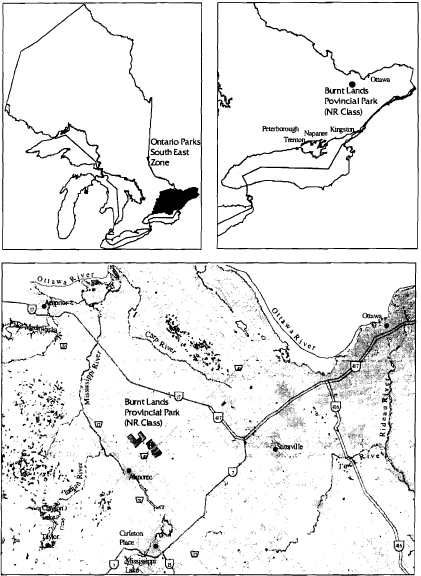
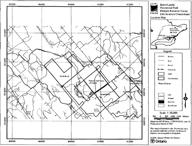
The recommended park (the property) is located approximately 5 km east of the Town of Almonte, 30 km west of Ottawa (Figure 1). The property is located in Ecodistrict 6E–11, which lies within MNR Kemptville District, and is administered by the South Eastern
Zone of Ontario Parks. The area is within the watershed of Mississippi Valley Conservation. The property straddles the OLL LUS planning area boundary, which is also the boundary between the Town of Mississippi Mills, Lanark County and the former Township of West Carleton, now Ward 5, in the City of Ottawa. At the time of preparation of this IMS, the total size of the area to be recommended for regulation was 522 ha consisting of 386 ha of Crown land and 137 ha owned by NCC.
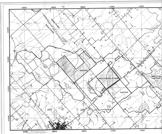
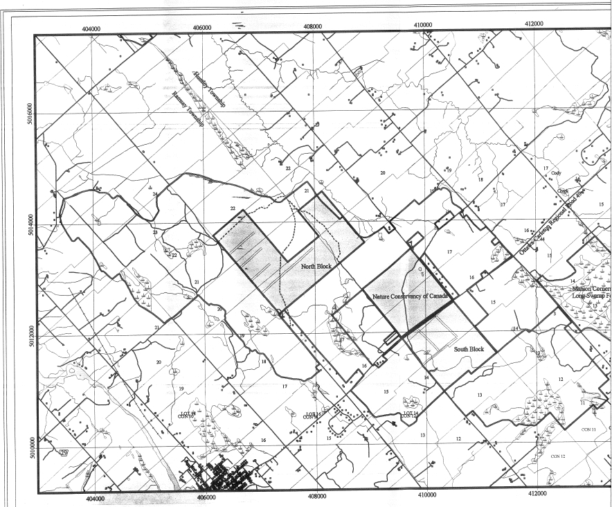
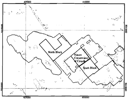
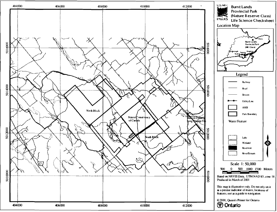
The property consists of three discrete blocks of land (Figure 2). The Crown lands consist of property in the geographic Township of Huntley now in Ward 5, City of Ottawa (Concession 12, Lots 1–4, 15 and Pt. Lots 19 & 20) and property located in the geographic Township of Ramsay now in the Town of Mississippi Mills, County of Lanark (Concession 12, Lot 19 and Pt. Lots 20 & 21). The Crown land is also referred to as a South block and North block based on the division of the properties by Regional Road The NCC property (refer to Land Tenure below) is within the geographic Township of Huntley now in Ward 5, City of Ottawa (Concession 12, Lots 16 and 17).
Figure 1. Regional Context, Burnt Lands Provincial Park
4.0 First Nations
As described above, the recommended park includes two blocks of Crown land and one block of privately owned land. It also falls within the Algonquins of Pikwakanagan land claim that is being negotiated by Ontario, Canada and the Algonquins concurrent with preparation of this IMS. In August of 1994, all parties signed a document titled Statement of Shared Objectives, where, amongst other items, private lands were agreed not to be involved in the negotiations process.
Management Guideline:
- The creation of this recommended park and its management will not abrogate or derogate from any Aboriginal or Treaty rights, as recognized and affirmed by section 35 of the Constitution Act, 1982
- Ontario Parks will communicate and work with the Algonquins throughout the planning and development of the recommended park
5.0 Land Tenure
NCC acquired a 134.88 ha parcel of federal Crown land from Public Works Canada in 1998, through the Legacy 2000 program. The land acquisition was achieved through Public Works Canada transferring the former Department of National Defence property to NCC for heritage preservation. The transfer contained a provision that the land be given legal protection status. The lands are described as parts 1, 3 and 5 of Plan 4R–12512, received and deposited in the Land Registry Office of Ottawa–Carlton. A copy of the plan is available at the Ontario Parks South Eastern Zone Office. A dedication ceremony held October 16, 2000 recognized the unified commitment of parties that effected the securement of the Legacy 2000 property, namely The Nature Conservancy of Canada, Ontario Parks, Public Works and Government Services Canada, Department of National Defence, Canada Millennium Partnership Program, and the Aggregate Producer’s Association of Ontario.
The Crown (Ontario Parks) entered into a two–year term custodianship agreement with NCC effective October 21, 1998 for the above noted property. At the end of the custodianship agreement, the two partners will enter into a 99 year lease agreement. Based on the agreement, Ontario Parks administers, protects and manages the property on behalf of NCC to protect its ecological value and for the benefit of the people of Ontario. Management decisions require joint approval between Ontario Parks and NCC.
Management Guideline:
- Similar to the custodianship agreement, the lease agreement will clearly state that Ontario Parks has an obligation to maintain the NCC property in a natural state and preserve biological diversity. In other words, through the lease agreement, Ontario Parks will be obliged to take whatever action is required to accomplish this, under joint approval of any proposed action.
The former Township of West Carleton has ownership of a 22 m wide "public road" running east–west in Lot 17, Cone. 12 (PIN# 0021) and a 6 m wide road meandering through both Lot 16 & 17, Cone. 12 (Quarter Sessions Road, PIN#0023), described as Parts 2 and 4 of Plan 4R–12512. The Quarter Sessions Road is still passable, with some sections continuing in use. These parcels have been included in the area proposed for regulation. There has been some interest by NCC and MNR in removal of the existing roads and reestablishment of alvar habitat (Section 8.0).
Several sections of unopened municipal road allowances that are not used nor needed to access private lands have been included within the area to be regulated (Figure 2).
6.0 Provincially Significant Areas and Land Use Designations
The recommended park will protect approximately 25% of the lands within the provincially significant, Burnt Lands Alvar ANSI. The ANSI is the only extensive alvar within Ecodistrict 6E–11 (the Smith’s Falls limestone plain physiographic region (Chapman and Putnam 1984)). The site stands in a class by itself in terms of condition, extent, alvar development, and significant species and features (Brunton 1986; Reschke et. al. 1999). This 1500 ha Life Science ANSI was identified in the Carleton Place District Land Use Guidelines in 1983. Properties within the ANSI have been eligible for the Conservation Land Tax Rebate Program and its successor the Conservation Land Tax Incentive Program (CLTIP) since 1987. The NCC property is enrolled within the CLTIP. A draft Management Plan was prepared for the ANSI by the Carleton Place District in 1991.
As the ANSI is located within two municipalities, different policies apply throughout (refer to Section 2.0 Location). The Official Plan for the Municipality of Ottawa–Carleton identifies the ANSI area as Natural Environment “B". The Official Plan for West Carleton Township designates the ANSI area as Marginal Preservation (excepting Pt. Lots 19 and 20 that are Marginal Resource). The existing Ramsay Township Official Plan identifies the portion in the former Ramsay Township as Rural, giving no protection to the ANSI area. The Town of Mississippi Mills has a new Official Plan adopted by Council and approved by the Province, but not enforced and in effect due to a landowner appeal to the Ontario Municipal Board. This new Official Plan establishes the properties in a Rural zone, with ANSI core, ANSI general and Deer Yard overlays. The lands adjacent to the recommended park are within the ANSI boundary, and have municipal zonings of Natural Environment "B", Marginal Resource: Pits & Quarries, Rural, General Rural and Agricultural.
Management Guideline:
- Ontario Parks will work with other MNR programs, the municipalities, and neighboring landowners to protect and/or manage adjacent lands in a manner that complements the protection of the alvar and the recommended park.
7.0 Land Securement
The area recommended for regulation at this time is but a small portion of the ANSI. Concerns related to the ecology of the alvar, restriction of access, buffering from adjacent land use and maintenance of genetic diversity remain.
Management Guideline:
- Ontario Parks supports continuing landowner contact programs to inform and educate owners of lands within and adjacent to the ANSI.
8.0 Access, Existing and New Development
Ottawa–Carleton Regional Road 49 (formerly King’s Highway 44) is the primary access road to the site and forms the boundary between the South Block and NCC property. The Quarter Sessions Road is used to access the NCC property. A locked gate blocks passage on this road at the fenceline. There is a firebreak network throughout the area proposed for regulation.
Several road allowances adjacent to the Crown lands and NCC property have not been included in the area to be regulated. There is a history of access concerns within the recommended park. Ease of access has led to several management concerns within the recommended park, including impacts from vehicular traffic and dumping of materials. Deposition of both garbage and construction material have negative ecological and aesthetic impacts on the alvar, and could become a hazard.
One concrete building measuring 25.8 m2 remains on NCC property along with concrete base plates for the antennae and numerous anchor points as documented in "Department of National Defence Environmental Disclosure Report, Almonte Antennae Yard", July 1995 and "Environmental Property Transfer Assessment, Almonte Antennae Farm" July 1997. The concrete building may have some historical significance. The interior may be of use for storage of materials related to management of the recommended park.
A Lanark County sign was installed by the County on the NCC property, under a signed licence agreement. The sign may contribute to view by the public of the property as idle land. The agreement period has ended; NCC must give one month written notice to the County requesting that the sign be removed.
Management Guideline:
- Methods to address access concerns will be determined in the interim and during the management planning process
- Interim access management may include installation of signage identifying the significance of the area, installation/repair of fencing and creation of an interim entrance and parking area
- Potential for removal and restoration of sections of the Quarter Sessions Road will be determined in consultation with NCC and the former Township of West Carleton. If desired, materials removed could be used to create aninterim parking area adjacent to the Regional Road
- Opportunities for closure and/or restriction of access along road allowances adjacent to the proposed regulated area will continue to be negotiated with adjacent landowners and the municipalities in the interim and during management planning
- Garbage will be removed from the site. It is anticipated that controlled access will reduce this concern
- NCC will request that Lanark County remove their signage from within the recommended park boundary
9.0 Recreational Features and Activities
Due to their unique habitat and rare species, alvars offer opportunities for ecotourism. Passive day use activities are allowed in nature reserves. There is some use of the area for hiking and nature appreciation. Although no official trails exist, many incidental trails are evident and firebreaks are located throughout the properties. The alvar is featured in "A Nature Guide to Ontario" (Wake 1997) and in "Nature and Natural Areas in Canada’s Capital" (Brunton 1998) and is an annual destination for the Ottawa Field Naturalists' Club field trips. The actual amount of use or potential tourism value of the site is not known. The most visible and accessible areas of those proposed for regulation are the two blocks adjacent to Regional Road 49.
Alvars have very thin or non–existent soils, easily damaged by heavy use. Disturbance may encourage the invasion of weedy species into the alvar, decreasing the species diversity of the alvar communities. Alvars recover very slowly from impacts such as ruts from motorized vehicle traffic. There are several trails within the area for which amount of use has not yet been determined. An unopened and unmaintained Township road allowance between the geographic Townships of Ramsay and Huntley runs from Regional Road 49 in a north westerly direction alongside the NCC property, and through a section of the North block of Crown land.
There is a history of recreational use of the site by 4x4's and All Terrain Vehicles (ATVs), and this is one of the most significant issues of the property. This use is not authorized, and will not be permitted within the recommended park boundary.
An Ontario Federation of Snowmobile Clubs (OFSC) snowmobile trail maintained by the West Carleton Snowmobile Trails Association follows the road allowance described above (Ontario Parks 2001). The municipality permits use of the unopened and unmaintained road allowance in its current condition. The snowmobile trail route may deviate from the road allowance as it passes through the North block of Crown land within the recommended park boundary. This section of trail does not have authorization from MNR. An offshoot of this snowmobile trail follows the interior fenceline through the NCC property to connect the road allowance with Burnt Lands Road to the East; this offshoot has not been authorized by NCC. The OLL LUS policy for new parks is that existing authorized recreation trails will be permitted to continue; "authorized" is defined as that received from MNR. Since these trails are not authorized, they are a non-conforming use.
Figure 2: Blocks of Land inside the Burnt Lands Provincial Park
Enlarge Figure 2: Blocks of Land inside the Burnt Lands Provincial Park
There is some use of the property for horseback riding. Provincial park planning and management policies state that horseback riding is not compatible with Nature Reserve class parks, and that existing use will be phased out. Other domestic animals (e.g. dogs) have been allowed free run of the property, resulting in disturbance to vegetation and wildlife species. Domestic animal faeces are a source of weed seed introduction.
The MNR has permitted sport hunting on the Crown land identified in this IMS as proposed for regulation under the Provincial Parks Act. NCC does not permit hunting on lands in their ownership. Both the Ontario Provincial Parks Planning and Management Policies (1992) and the Ontario’s Living Legacy Land Use Strategy (1999) identify that sport hunting is not compatible and therefore is not permitted within Nature Reserve class parks (Section 11.3). In accordance with the Environmental Assessment Act, areas recognized under the OLL LUS are to be managed according to provincial park planning and management policies until they are in regulation. Therefore, in accordance with Nature Reserve class park policy, sport hunting is not a permitted activity within the recommended park area. Ontario Parks will not be pursuing a regulation under the Fish and Wildlife Conservation Act concurrent with regulation under the Provincial Parks Act, and at that time will have regulatory authority to prohibit sport hunting.
Management Guideline:
- Appropriate location(s) for public access and design for marked foot trails will be determined through a Park Management Plan for the recommended park. Trails will be designed to reduce disturbance to areas of significance and sensitivity to use, while allowing enjoyment of the unique habitat (e.g. dry land boardwalk)
- In the interim and through management planning Ontario Parks, with consultation with NCC, will determine and implement effective means (e.g. signage/fencing/pedestrian entrance(s)) to limit public access to a controlled access point(s)
- In the interim Ontario Parks will be conservative in allowing and facilitating access to the site. Disturbance to sensitive vegetation will be minimized by encouraging use of the fire breaks as a trail system for passive day–use activities (liking, self–guided nature appreciation, cross–county skiing, snowshoeing)
- Use by groups must be compatible with the protection needs of the recommended park. Groups will be encouraged to contact MNR/Ontario Parks staff prior to visiting the site
- Location, amount of use, and type of use of all trails within the recommended park will be determined in the interim
- The location of the snowmobile trail within the North block will be con'firmed, and impacts to the values of the recommended park will be determined
- Unless an alternate route is agreed upon through discussion between Ontario Parks, the OFSC and the West Carleton Snowmobile Trails Association, the snowmobile trail passing through the North block along the road allowance will be permitted to continue subject to management prescriptions determined through management planning. Determination of alternate routes must consider potential impacts to the surrounding ANSI
- The West Carleton Snowmobile Trails Association will be contacted to discuss options for closure and/or relocation of the snowmobile trail that is currently within the NCC property
- Other than the snowmobile trail described above, recreational motorized land vehicle (e.g. ATV) use of any kind will not be permitted2 • The use of motorized transportation by MNR will conform to these standards wherever possible
- Horseback riding is a non–conforming use that will not be permitted
- In the interim, signage will be posted to identify that domestic animals must be kept leashed within the property, and dogs must be kept under control at all times. Once regulated, "Stoop and scoop" provisions will be in place (O.Reg. 767/94), these provisions will be encouraged in the interim. The question of compatibility of domestic animals with the heritage features of a Nature Reserve class park will be addressed through park management planning
- The formation of a locally based group will be considered as a mechanism for assisting Ontario Parks with specific management issues such as monitoring and reduction of access concerns, and promotion of intrinsic values (Section 14.0)
- Sport hunting will not be permitted within the recommended park. Ontario Parks will work with Kemptville District MNR to determine mechanisms for prohibiting sport hunting prior to regulation of these lands under the Provincial Parks Act.
10.0 Resource Inventories
Due to the distinctiveness of the site, there have been several inventories completed. Most inventory work has concentrated on life science features within the alvar communities. A life science checksheet has been completed for the site, and an earth science checksheet will be completed, coordinated by Ontario Parks Main Office. A summary of background information is attached (Appendix II).
10.1 Earth Science Features
Alvars are generally defined as natural communities established on areas of exposed bedrock or thin soil over bedrock. The recommended park is part of the Smiths Falls limestone plain, the largest and most continuous tract of shallow soil over limestone in Southern Ontario (Chapman and Putnam 1984). The area is characterized by thin soils overlying Paleozoic limestone formed during the Middle Ordovician Period. The area is underlain by 'softer' paleozoic bedrock known as Ottawa formation limestone. The property is topographically very homogeneous, consisting of a relatively flat bedrock plateau centred on the NCC property and sloping away gently to the west, north and south (Brunton 1986). Many fault lines and fissures allow water to seep away, maintaining xeric conditions after spring thaw.
Management Guideline:
- It is recommended that a complete earth science inventory be conducted prior to completion of a Park Management Plan
10.2 Life Science Features
A life science inventory of the Burnt Lands Alvar ANSI was conducted in 1985 (Brunton 1986). Additional studies of selected plant and wildlife groups have been undertaken since, primarily under the International Alvar Conservation Institute (IACI) (Bouchard 1998; Reschke et. al. 1999). It has been determined that the site provides habitat for vascular plants indicative of alvar habitat, including one globally rare (G3), 3 provincially rare and at least 20 regionally rare plants. A ribbon snake sighting has been confirmed (Cuddy 2000). Several significant insect species including butterflies, owlet moths, ground beetles, grasshoppers and sawflies and nine globally rare species of land snail have been recorded. The site is habitat for 5 regionally significant bird species. The IACI identifies 5 "priority one" alvar community occurrences within the Burnt Lands Alvar ANSI, all of which are represented within the recommended park. The life science features are discussed more fully in the Life Science Checksheet for the recommended Nature Reserve class park (Appendix III).
Jack pine planted on the Crown land properties in 1966 are in some areas encroaching on alvar vegetation communities, limiting vegetation growth due to shading, competition and modified soil pH. This encroachment has been identified as a management concern for many years, and is identified in this IMS as requiring custodial management action (Section 11.1).
Much of the life science information has been gathered throughout the entire ANSI area, and must be confirmed within the recommended park. In addition, inventories have largely concentrated on vascular plant species. There are a number of gaps in information on existing species, specifically relating to non–vascular plants, insects, birds, reptiles and mammals.
Management Guideline:
- Life science resources of the recommended park will be reassessed and gaps in the life science inventory will be filled prior to completion of an approved Park Management Plan. Partners and researchers will be encouraged to provide inventory information that is currently lacking
10.3 Cultural Resources and Traditional Land Uses
The NCC property was previously a communication tower site for the Department of National Defence. Communications towers erected in 1960 have since been removed from the property (concrete base plates remain). A bunker, previously used to contain a backup generator and batteries for the communications towers, remains on the property. No evidence of aboriginal use of the property has been found.
Management Guideline:
- The historical significance of the existing structure and concrete base plates on NCC property will be investigated. Once historical significance has been determined, potential uses of the building (including interpretation and storage) and potential for removal of the concrete base plates will be reviewed in consultation with NCC
11.0 Resource Stewardship
Due to the extent of life science inventories that have been conducted, and well documented management recommendations, there is sufficient information available to support some resource stewardship activities in the interim.
Management Guideline:
- Direction for the preparation of detailed resource management strategies, including wildlife, vegetation, fire and cultural resources, will be addressed by an approved Park Management Plan
- Until resource management strategies are in place, Ontario Parks will work with MNR Kemptville District to manage and protect identified critical habitat (e.g. snail sites, S1 grass community)
11.1 Vegetation Management
Existing and ongoing research suggests that fire may be required as part of the natural process of alvar succession within the recommended park (Catling and Brownell 1998; Catling and Sinclair 2000). Further research is required to confirm whether prescribed burning is required as a management tool for this property.
Several invasive, non–native species have become established within the recommended park. These may require control to protect species at risk and/or the species diversity of the site.
Further information is required prior to restoration of any areas where jack pine are removed, areas affected by the fire in 1999, firebreaks and the Quarter Sessions Road.
Management Guideline:
- Vegetation management will be directed toward ongoing natural succession, unless alternative strategies are desirable
- Fire and its role within the alvar will continue to be determined. Any prescribed burning will follow MNR prescribed burn planning processes
- Fire may be suppressed within the recommended park if it is deemed harmful to the natural heritage values of the property
- Jack pine will be removed from some areas within the recommended park in the interim. Priority will be given to meadow areas in the North block where the existing alvar vegetation is being the most negatively affected. A harvesting method that minimizes disturbance to the site will be selected
- Restoration and vegetation control will be based on an approved management plan and vegetation management plan and fire management strategy if required.
11.2 Fire Management
The areas of the recommended park located in the City of Ottawa lie Outside the Fire Region (OFR) as defined by the Forest Fire Prevention Act. Responsibility for fire suppression OFR lies with the municipality. The Lanark County portion of the recommended park is within (Inside) the Fire Region (IFR, Zone EFR 4) and responsibility for fire suppression on Crown land IFR lies with the MNR, although actual fire suppression may be contracted to the Town of Mississippi Mills in the future. The municipalities (fire department) will be the first to respond on the properties whether IFR or OFR. The MNR is currently developing a new Provincial Fire Management Strategy in which every Region (IFR and OFR) will be addressed.
Suppression of a wildfire occurred on the South block of Crown land in June of 1999. Fire breaks resulting from fighting the 1999 fire within the South block disrupted alvar habitat and research plots and increased the potential for damage to the property from vehicular access. A study of natural succession following the fire is being carried out (Catling et al 2000).
Management Guideline:
- The recommended park will be managed as per the Regional Fire Management Strategies. Fires will be suppressed unless stated otherwise in an approved Park Management Plan
- Access to the properties resulting from firefighting measures will be blocked
- Restoration of areas disrupted by firefighting measures will be addressed in an approved Park Management Plan and vegetation and fire management plan(s) if required, with input from District and Regional Ecologists
- Ontario Parks will determine opportunities to prevent damage to established research areas during ·fire suppression through discussion with the MNR Area Team and the Municipalities
11.3 Wildlife Management
The recommended park is located within Wildlife Management Units 64A (Lanark County) and 64B (City of Ottawa). The properties provide significant wildlife habitat as they are situated in an important winter deer range (DLUG, 1983). Kemptville District MNR is developing a management strategy to reduce overall deer populations in these and other Wildlife Management Units in order to reduce deer damage to private lands and wintering areas. Provincial Park Policy identifies that sport hunting is not permitted in Nature Reserve class parks (OMNR 1992; OMNR 1999).
At this time, under the current regime of sport hunting, there are no known wildlife concerns on the property. There is much evidence that deer are threatening some Species at Risk in other Provincial Parks where sport hunting is not permitted (Cuddy 2000.). A deer browse study initiated in 1997 in partnership between MNR and York University is ongoing. It is possible that if the deer population is not managed, over browsing may result in loss of species or changes in species composition or abundance. Provincial Park Planning and Management Policies state that wildlife population management may be allowed in Nature Reserve class parks as a resource management policy (OMNR 1992), under the direction of an approved Park Management Plan, and a Wildlife Management Resource Stewardship Plan if needed.
Management Guideline:
- Deer browse will continue to be monitored at least annually by Ontario Parks and the District and/or Regional Ecologist
- In the interim, a deer population reduction program will be allowed if monitoring clearly indicates it is required to ensure protection of Species at Risk (Section 11.4)
- During park management planning, a deer population reduction program will be proposed as a management action to protect the natural heritage features of the property. Appropriate methods for wildlife population management will be considered. Any reduction method would conform with other management guidelines for the Nature Reserve class park (e.g. no motorized vehicle use)
11.4 Species at Risk
A number of provincially and regionally rare species have been identified within the recommended park and on surrounding lands. Specific management needs for these species will be determined through the appropriate resource stewardship plans and/or species and ecosystem recovery plans.
Management Guideline:
- Management will ensure the protection of any species which is declared to be of special concern, threatened or endangered as listed in Schedule A of Park Planning Directive 11.03.02 – Protection of Vulnerable, Threatened and Endangered Species in Parks
- Specific locations of species deemed to be at risk will not be divulged to the public
- Ontario Parks will work with researchers and the Natural Heritage Information Centre to study and monitor rare species in the recommended park
12.0 Commercial Activities
There are two licenced quarries within the Burnt Lands Alvar ANSI, which predate the designation of the ANSI and have been excluded from the ANSI boundary. Mining and Surface Rights of 127 acres in Ramsay Township (North block) were withdrawn from staking on May 14th, 1999, due to the recommended provincial nature reserve status of the lands. There is no recent evidence of commercial activity within the recommended park. Commercial activities (e.g. fur harvest, forestry, tourism) will not be permitted within the recommended park.
Management Guideline:
- Aggregate extraction will not be allowed within the recommended park due to the significance and sensitive nature of the alvar ecosystem
13.0 Research and Monitoring
Alvars are important habitats for research related to our understanding of past vegetation and the impacts of climatic change on vegetation, the effects of environmental changes involving drought and fire, and research in the fields of evolution, taxonomy, and biogeography. Research that will assist in ensuring educated management decisions related to the alvar habitat will be encouraged. Ontario Parks South Eastern Zone has prepared a Research Strategy to guide research throughout the Zone.
Due to the rarity of alvar environments, and the exceptional quality of the Burnt Lands, there has been, and will continue to be, significant research interest by MNR, university, conservation and scientific groups and others. Ongoing research includes a deer browse study (partnership between MNR and York University), a study of succession following the fire that occurred in June of 1999 (partnership between MNR and University of Ottawa), insect population studies by Agriculture and Agri–Food Canada and studies of land snail populations. A coordinated program of research investigation for this unique ecosystem is being developed.
Under the lease agreement for the NCC property, Ontario Parks will grant NCC access to the property to monitor/inspect actions taken with respect to the IMS and Park Management Plan, or for the purposes of studies carried out by authorized researchers acting with the permission of Ontario Parks and NCC. Access will be subject to prior written notice of at least 24 hours and receipt of any necessary approvals from Ontario Parks under Provincial Park legislation or policy (e.g. research).
Management Guideline:
- Research by qualified individuals that contributes to knowledge of natural and cultural history and to environmental management will be encouraged
- All research must be compatible with heritage values and recreational uses and conform to the research policies and strategies for provincial parks, South Eastern Zone Ontario Parks and NCC
- Once regulated under the Provincial Parks Act, all research within the nature reserve, including research by Ontario and federal government agencies, will require Ontario Parks approval and must meet all other applicable provincial and federal requirements
- Research will be geared to minimizing disturbance on vegetation communities, sites altered by research activities will be restored as required
- Ontario Parks will collaborate with other partners (agencies, organizations, individuals) to further understanding and conservation of alvar ecosystems
- Ontario Parks will endeavor to publish and transfer information and knowledge gained from research and monitoring
- Priority will be given to research in the areas of:
- Alvar ecology, succession
- Ecological restoration, vegetation management, wildlife management
- Quantitative and qualitative inventories of flora and fauna
- Monitoring of ecological processes, flora and fauna, species at risk
- Inventory and monitoring and control of invasive species
- Under the lease agreement for the NCC property, NCC will be granted access to the property to monitor and/or inspect any actions taken under the IMS, and for authorized research activities.
14.0 Marketing and Partnerships
As a means of encouraging compatible uses, the recommended park will be given a low profile in Ontario Parks communications. Local landowners, naturalist clubs and similar groups may have interest in learning about and participating in monitoring of the property.
In terms of forging partnerships with the research community, Ontario Parks will promote the educational role of the recommended park. Provincial park policy dictates that nature reserves be areas selected to represent the distinctive natural habitats and landforms of the province which are protected for educational purposes and as gene pools for research to benefit present and future generations. Ontario Parks will also promote the protection and heritage appreciation objectives and the need to ensure control of access and limits on use of the property. The OLL LUS (1999) states that existing and recommended Provincial Parks will be managed to ensure that their natural and cultural values are retained and enhanced.
Management Guideline:
- If partnerships can be arranged, natural heritage agencies, naturalist clubs, museums or individuals could be instrumental in providing regular monitoring of the property. Specific partnerships will be explored with NCC, local landowners, the OFNC, museums, universities, researchers, and other regular users of the recommended park
- Ontario Parks will continue to market the science and research opportunities related to the recommended park
- Volunteers and local partnerships could be engaged in supporting the production of brochures, maps and other written or audio/visual materials on the natural values of the site, with the assistance of Ontario Parks
15.0 Client Services
Information on the recommended park is on file in the Ontario Parks, South Eastern Zone office (Kingston) and with the Superintendent of Fitzroy Provincial Park, who is responsible for administration of this area.
Management Guideline:
- For general inquiries, information can be provided by contacting the Superintendent at Fitzroy Provincial Park or the Ontario Parks, SE Zone office. More detailed information may be circulated at the discretion.of Ontario Parks staff if requested
- Ontario Parks may conduct guided tours of the property for interested persons and or groups in order to raise awareness of the site and to educate visitors on the compatible uses and stewardship of the recommended park
- Under the lease agreement for the NCC property, Ontario Parks will grant NCC access to the property for the purposes of conducting site visits with donors (or potential donors) to the Ontario Parks Legacy 2000 Program
16.0 EA Act Requirements
As part of the Ministry of Natural Resources, Ontario Parks is a public sector agency, and is subject to the Environmental Assessment Act. Once in regulation, management activities within the recommended park will be carried out in accordance with the conditions set out in Exemption Order MNR–59/2 and Declaration Order MNR 65.
17.0 Implementation
Administration and operation of the recommended park is led by Ontario Parks, with custodial management by the Superintendent of Fitzroy Provincial Park. Implementation of the protective provisions within this IMS will require funding and staffing resources.
Management Guideline:
- The Ontario Parks South Eastern Zone Manager will investigate funding options to support interim management of the recommended park
- Establishment of partnerships could assist in monitoring of the protective provisions within this IMS and reporting to Ontario Parks (Section 12.0)
- Ontario Parks will determine methods for enforcement of protection guidelines outlined within this IMS prior to and following regulation of the Nature Reserve class park
18.0 References
Brdar, C. 2000. Burnt Lands Provincial Nature Reserve–Natural Heritage Area Life Science Checksheet. South Eastern Zone Ontario Parks.
Brunton, 1998. Nature and Natural Areas in Canada’s Capital. The Ottawa Citizen in co–operation with the Ottawa Field–Naturalists' Club, Ottawa, Ontario.
Brunton, D.F. 1986. A Life Science Inventory of The Burnt Lands, Lanark County/Regional Municipality of Ottawa–Carleton, Ontario.Carleton Place District, Ontario Ministry of Natural Resources.
Catling, P.M. and A. Sinclair. 2000. A basis for the use of Fire in protection and management of biodiversity in the alvar landscape of the Burnt Lands, Regional Municipality of Ottawa–Carleton, Ontario. Unpublished report.
Catling et. al.. 2000. Vascular plants of a successional alvar burn 100 days after a severe fire and their mechanisms of re–establishment. Unpublished report.
Catling, P.M. and V.R. Brownell. 1998. Importance of fire in alvar ecosystems evidence from the Burnt Lands, Eastern Ontario.Canadian Field Naturalist 12(4): 661–667.
Chapman, L.J. and D. F. Putnam. 1984. The Physiography of Southern Ontario, Third Edition. Ontario Geological survey, Special Volume 2. Ontario Ministry of Natural Resources.
Cuddy, D. 2000. Personal Communication.
Grand, J. 1998. The Burnt Lands Alvar Habitat Conservation, 1998. International Alvar Conservation Institute.
Ontario Ministry of Natural Resources. 2000. Burnt Lands Alvar Background Information Report Notes. Ontario Parks SE Zone. Draft, July 2000.
Ontario Ministry of Natural Resources. 1999. Ontario’s Living Legacy and Use Strategy (July 1999).
Ontario Ministry of Natural Resources. 1992. Ontario Provincial Parks: Planning and Management Policies (1992 Update). Provincial Parks and Natural Heritage Areas Policy Branch.
Ontario Ministry of Natural Resources. 1991. Management Plan for the Burnt Lands Alvar, Ramsay and West Carleton Townships, Carleton Place District. Draft. Version 3.
Ontario Ministry of Natural Resources. 1983. Carleton Place District Land Use Guidelines.
Reschke, C. et. al. on behalf of the Alvar Working Group. 1999. Conserving Great Lakes Alvars, Final Technical Report of the International Alvar Conservation Initiative.
Wake, Winifred (Cairns) ed. 1997. A Nature Guide to Ontario. Federation of Ontario Naturalists/University of Toronto Press. xxxiii + 469p
19.0 Appendices
Appendix I: Interim Resource Management and Recreation Activities Policies
This table focuses on the activities and policies that are addressed in the IMS. The section that contains complete discussion of interim management direction is listed. Refer to existing Provincial Park Policy (PPP) for a comprehensive list of policies that apply to Natural Environment class parks.
| Activity | Interim Direction | Reference Policy Document | IMS Section |
|---|---|---|---|
| Aggregate Extraction | N | PPP | 12.0 |
| All–terrain vehicle use (ATV) | N | PPP | 9.0 |
| Commercial timber harvest | N | OLL | 12.0 |
| Fire Suppression | Y | PPP | 11.2 |
| Horseback Riding | N | PPP | 9.0 |
| Prescribed Burning/Prescribed Natural Fire |
PMP | PPP | 11.1 |
| Snowmobiling | Y3 | OLL/PPP | 9.0 |
| Sport Hunting | N | PPP/OLL | 9.0 |
| Trails Existing | C/PMP | PPP | 7.0 |
| Trails New | PMP | 7.0 | |
| Vegetation management | PMP | PPP | 11.1 |
| Wildlife Population Management | PMP | PPP | 11.3 |
Legend
Interim Direction:
C – controlled – some use to be permitted with restrictions
PMP – to be determined through future management planning
N/A – not applicable
N – not permitted
Y – pemitted activity
Reference Policy Document:
OLL – Ontario’s Living Legacy Land Use Strategy (19999)
PPP – Ontario Provincial Parks: Planning and Management Polices (1992 update)
Appendix II: Summary of Background Information
| Park Name | Burnt Lands Provincial Park |
|---|---|
| Classification | Nature Reserve |
| Ecoregion–Ecodistrict | South Central Region/Kemptville District |
| Total Area (ha) | 521 |
| Regulation Date | Pending |
Inventories
| Survey Level | Earth Science | Life Science | Cultural | Recreational | Other |
|---|---|---|---|---|---|
| Checksheet | 2000/01 | 1986, 2000 | 2000 | ||
| Reconnaissance | 2000 | 2000 | |||
| Detailed |
Earth Science Representation
Exposed or very finely covered bedrock, relatively flat plateau, many fault lines and fissures allow water drainage, maintaining xeric conditions.
Life Science Representation
The site provided habitat for vascular plants indicative of alvar habitat, including one globally rare, 3 provincially rare and at least 20 regionally rare plants. Several significant insect species and nine globally rare species of land snail have been recorded. The site is habitat for 5 regionally rare bird species. There are 5 "priority one" alvar community occurrences.
Cultural Resource Representation
N/A (a communications site bunker is located on NCC property).
Recreational Opportunities
Hiking, Cross–country Skiing, Nature Appreciation.
Appendix III: Natural Heritage Area – Life Science Checksheet
| Name | Map Name | Map Number | UTM Reference | Latitude | Longitude | NAD | Minimum Altitude | Maximum Altitude |
|---|---|---|---|---|---|---|---|---|
| Burnt Lands Provincial Park (Nature Reserve Class) | Arnprior | 31 F/8 | 100120 | 45° 15' N | 76° 09' W | 27 | 130 m | 160 m |
Map: 31 F/8
| County | Locality | Township | Area | Ownership |
|---|---|---|---|---|
| Ottawa–Carleton and Lanark | 5 km NE of Almonte | West Carleton (Huntley) & Mississippi Mills (Ramsay) | 493 ha | NCC/Crown |
| MNR Region | Ecoregion and Ecodistrict | Landform Unit(s) | MNR District | OBM |
|---|---|---|---|---|
| Southcentral | 6E–11 | Smith Falls Limestone Plain (Chapman and Putnam 1984) | Kemptville | 1018405050100; 10 18410050100 |
| Aerial Photographs 1:30,000 | |||
|---|---|---|---|
| Year | Roll | Flight Line | Number |
| 1993 – | 353 – | 33 – | 139–142 |
| 1993 – | 353 – | 34 – | 174–177 |
| Aerial Photographs 1:10,000 | |||
|---|---|---|---|
| Year | Roll | Flight Line | Number |
| 1991 – | 25 – | 4516 – | 180–195 |
| 1991 – | 22 – | 4517 – | 165–180 |
| 1991 – | 3 – | 4518 – | 80–95 |
| 1991 – | 37 – | 4519 – | 10–20 |
Physical and Biological Features
Representation
Alvars are mosaic ecosystems of grassland, savanna, and sparsely vegetated rock barrens that occur on flat limestone or dolostone bedrock where soils are thin or absent. They represent an entire successional gradient from bare rock through alvar meadow to mature forest. Most alvar community types are globally imperiled, and support globally rare species. The best and most extensive examples of alvars in North America occur on glaciated limestone plains in the Great Lakes Basin.
The Burnt Lands Alvar Nature Reserve protects ~33% of the greater Burnt Lands Alvar Area of Natural and Scientific Interest (ANSI). This ANSI is the best representative alvar in site district 6E–11, in terms of both its size and the diversity of community types contained within it. The International Alvar Conservation Initiative (IACI) ranked the Burnt Lands Alvar as B1, or of outstanding significance, based on the concentration and quality of globally rare vegetation communities found within it. Additionally, Burnt Lands is the most easterly alvar in Ontario, and is separated from most other alvars in Ontario by the Frontenac Axis.
Burnt Lands Alvar is one of the five most diverse alvars in the Great Lakes Basin; five of the 13 alvar vegetation community types identified by the IACI as being globally imperiled are represented in the protected area. Burnt Lands Alvar contains the best examples found in North America of two of these high priority community types – annual alvar pavement grassland and poverty grass dry alvar grassland (Appendix I).
A previous study (Brunton 1986) identified 14 different vegetation community types within the ANSI, 11 of which are found within the protected area. Two of these community types are provincially significant. This site was also surveyed as part of the International Biological Program (IBP) in 1970. The IBP findings are not documented here, as they have been superceded by more recent work.
The Nature Reserve includes sections of three significant alvar areas identified by Brunton (1986): the north block of Crown land ("Ramsay Alvar''), the Nature Conservancy of Canada property ("DND Alvar"), and the south block of Crown land ("South Block Woods and Alvar". These are described below:
- north block – largest area of open, natural alvar within the Burnt Lands; supports most of the alvar taxa known in the study area; supports only prairie dropseed (Sporobolus heterolepis) meadows in ANSI; rich in rock flats vegetation and flora
- NCC property – extensive example of later–successional, deeper–soil alvar; alvar pavement; wide variety of alvar shrubbery and turf species; Cirsium discolor population
- south block – mixed forest and alvar complex; most vegetational variation in entire Burnt Lands represented here; excellent Cypripedium arietenum populations
Condition
North Block:
This area is largely undisturbed, except for some damage from recreational vehicle use and a Jack Pine plantation. Much of the greater alvar area (Ramsay alvar) is on private land, large portions of which have been destroyed through housing development. This development affects the protected area by altering its hydrology and providing increased opportunity for weedy species to invade. Nonetheless, the west half (i.e. much of Mississippi Mills, Cone. XI) is still a prime alvar area.
NCC property:
Many parts of this property are highly disturbed, since it is easily accessible from Regional Road 49 and county roads and allowances. There is extensive damage from recreational vehicle use and garbage dumping in isolated patches. Additionally, there has been illegal sand quarrying on east side. Recreational horseback riding introduces seeds of invasive species. There are several human–made structures, including a Lanark County billboard installed in an alvar pavement area, the DND bunker, fences, roads, and firebreaks. Despite these disturbances, this block of land protects important alvar pavement.
South Block:
A fire that started on private land to the west of the site in 1999 spread onto Crown land and burned approximately 65 ha of mixed forest. Damage from firefighting and clean–up includes large firebreaks that were plowed through the central portion of site, as well as large piles of earth and woody debris. The firebreaks create greater access into the property for recreational vehicles and germination sites for weedy species.
Part of this section is covered in a Jack Pine plantation that is in poor health and may be shading out the natural alvar species. This site is fenced along the north and west side of West Carleton Conc. 12, Lot. 15.
Diversity
communities
Brunton (1986) recorded 11 vegetation community types (Appendix I) within the protected area, defined in terms of elevation, shade tolerance, and vegetation type: developed land; abandoned agricultural land; intolerant mixed forest; intolerant deciduous forest; intolerant coniferous forest; rock flats (provincially significant); alvar meadows (provincially significant); upland thickets; tolerant coniferous forest (has regionally important plant species); lowland intolerant deciduous forest; and wet meadow.
Reschke et al. (1999) noted five alvar vegetation community types (Appendix I) based on a physiognomic alvar classification system using ground cover types and tree cover: Juniper alvar shrubland; annual alvar pavement grassland; alvar nonvascular pavement; Little Bluestem alvar grassland; Poverty Grass dry alvar grassland.
fauna
Faunal observations have been made for the ANSI as a whole. The insect community is rich and diverse, with at least 50 species of butterflies. Brunton (1986) observed 84 species of birds. A small ephemeral pond within the NCC property supports a breeding population of Chorus Frogs (Pseudacris triseriata). There have been confirmed sightings of Ribbon Snake (Thamnophis sauritus) within the protected area (Cuddy, pers. comm.).
flora
The floral composition of this Nature Reserve is similarly rich. Over 450 species of vascular plants have been recorded in this area. Sixteen of these species are characteristic of alvars, and 5 of these almost completely confined to alvars (Catling 1995). Significant plant species are detailed in Special Features. There is also a high diversity of non–vascular plants, although this plant group has not been surveyed.
Ecological Considerations
Alvars are functional ecological units and to protect the Burnt Lands Alvar it is important to consider the processes that have shaped it. The protected area is small relative to the entire ANSI. About half of the Ramsay alvar, with its prairie dropseed meadows, falls on private land to the NW of the north block. Additionally, there is no buffer between the protected area and adjacent roads and private lands. There are currently two quarries close to the site within the greater Burnt Lands ecosystem. The private land within this ANSI is eligible in the Conservation Land Tax Incentive program.
The unique alvar communities found in this nature reserve are maintained by the ephemeral water regime. The area is flooded in the spring, but experiences drought in the summer. This water regime produces fen–like temporary pools and intermittent sheet flow, as well as above–and below–ground streams. The ecosystem is also maintained by fire, which is often prevented or suppressed due to the proximity of houses and other private property. Soil depth is another important determinant of species richness and composition.
Deer are plentiful at the site. It is likely that their browsing and trampling affect alvar vegetation, both by damaging individual plants but also by holding back succession in open areas. Four deer exclosure plots were established in the South Block in 1977 to study the effects of browsing on vegetation.
Special Features
fauna
Several significant and unusual insect species have been recorded within the Burnt Lands Alvar by a variety of investigators (Appendix II). Ontario’s alvars differ from one another in terms of their insect communities, and the prairie dropseed meadow’s insect community is unique (Bouchard 1998). At least nine significant butterfly species have been observed in the alvar area (Appendix II). There is also an unusually rich owlet moth (Noctuidae) fauna (Brunton 1986). Twelve of these moths are significant species for this area, and two are new to science.
Nine globally rare species of land snail have been recorded in the south block, and four of these are found nowhere else in Ontario: Vertigo hannai, Vertigo basidens, and two Vertigo species that are new to science (W. Grimm 2000, personal communication).
Brunton (1986) observed 3 bird species that are rare in site region 6E within the Burnt Lands Alvar ANSI (Cadman et al. 1987): Yellow–billed Cuckoo (Coccyzus americanus, S4), Common Raven (Corvus corax, S5), and Clay–coloured Sparrow S4 (Spize/la pal/ida, S4). He also noted 2 locally rare species: Hermit Thrush (Catharus guttatus, S5), and Rufous–sided Towhee (Pipilo erythrophthalamus, S4). There is further evidence of the regionally rare Sedge Wren (Cistothorus platensis, S4) and Mink Frog (Rana septentrionalis, S5) (White 1997).
flora
Alvars across the province differ in their floristic composition (Belcher et al. 1992, Catling and Brownell 1995). Burnt Lands Alvar supports a high number of rare "prairie" species, occurring well outside their normal range. Many plants are relict species normally found along the shores of the Great Lakes (Brunton 1986). At the NW corner of the north block is a large meadow of provincially significant Prairie Dropseed (Sporobolus heterolepis), which extends onto the unprotected portion of the Ramsay Alvar. Three provincially rare plant species are present within the protected area, along with at least 20 regionally significant plants (Appendix III).
Major Information Sources
Belcher, J.W., P.A. Keddy, and P.M. Catling. 1992. Alvarvegetation in Canada: a multivariate description at two scales. Canadian Journal of Botany 70: 1279–1291.
Bouchard, P. 1998. Insect diversity in alvars of southern Ontario. Unpublished report presented to Federation of Ontario Naturalists
Brunton, D.F. 1986. A life science inventory of the Burnt Lands. OMNR, Carleton Place.
Cadman, M.D., P.F.J. Eagles, and F.M. Helleiner. 1987. Atlas of breeding birds of Ontario. University of Waterloo Press, Waterloo.
Catling, P.M. 1995. The extent of confinement of vascular plants to alvars in southern Ontario. Canadian Field Naturalist 109 (2): 172–181.
Catling, P.M. and V.R. Brownell. 1995. A review of the alvars of the Great Lakes region: distribution, floristic composition, biogeography, and protection. The Canadian Field–Naturalist 109 (2): 143–171.
Catling, P.M., A. Sinclair, and D. Cuddy. in press. Vascular plants of a successional alvar burn 100 days after a severe fire and their mechanisms of re–establishment. Canadian Field–Naturalist.
Chapman, L.J. and D.F. Putnam. 1984. The physiography of Southern Ontario. Ministry of Natural Resources, Toronto.
Reschke, C., R. Reid, J. Jones, T. Feeney, and H. Potter. 1999. Conserving Great Lakes Alvars: Final technical report of the International Alvar Conservation Initiative. The Nature Conservancy, Chicago, IL.
White, D.J. 1992. Life science areas of natural and scientific interest in site district 6–11. OMNR, Kemptville.
White, D.J. 1997. Summary: Natural areas reports for natural areas west of Rideau River. Prepared for the Regional Municipality of Ottawa–Carleton, Planning and Development Approvals Department. 120 pp.
Significance Level (Provincial/Regional/Local) and Brief Summary of Major Representative Values
Provincial – alvar pavements and alvar grassland communities; representative conifer and mixed forest communities; globally, nationally, and provincially rare flora and fauna
Date Compiled: August, 2000
Compiler: C. Brdar, Ontario Parks SE Zone
Appendix IV: Vegetation Communities in the Burnt Lands Alvar
Reschke et al. (1999)
| Community | Description | Location | Significance |
|---|---|---|---|
| juniper alvar shrubland | Juniperus communis Rhus aromatica Viburnum rafinesquianum Solidago ptarrnicoides |
Crown and NCC | G3 |
| annual alvar pavement–grassland | Sporobolus neglectus, S. vaginiflorus Trichostema brachiatum Panicum philadelphicum herbaceous vegetation |
NCC | G2 |
| alvar non–vascular pavement | Tortella tortuosa Cladonia pocillum Placynthium spp. sparse vegetation |
NCC | G2 |
| little bluestem alvar grassland | Sporobolus heterolepis Schizachyrium scoparium herbaceous vegetation |
Crown | G2 |
| poverty grass dry alvar grassland | Danthonia spicata Poa compressa herbaceous vegetation |
Crown | G2? |
Brunton (1986)
| Community | Description | Location | Significance |
|---|---|---|---|
| upland intolerant mixed forest | Picea glauca Populus tremuloides Thuja occidentalis densely packed shrubbery |
throughout | may be largest extent in region location of some signifcant plants |
| dry rock flats | sparse vegetation includes a diversity of herbaceous species exposed bedrock will eventually succeed to alvar meadows |
Crown and NCC | provincial supports significant plants |
| alvar meadows | diversity of early successional plants | throughout | provincial supports the majority of significant plants |
| lowland tolerant coniferous forest | Thuja occidentalis sparse, diverse undergrowth |
Crown | supports significant plants |
Life Science Checksheet Location Map
Enlarge Life Science Checksheet Location Map
1 The Legacy 2000 Program was initiated in 1996 as a four–year agreement that solidified the existing partnership between the Ministry of Natural Resources and NCC for securement of significant natural areas in Ontario. Through the Legacy 2000 program, NCC, in conjunction with Ontario Parks, identified priority sites for protection. NCC negotiated with willing landowners, arranged appraisals and title searches, raised funds and helped with land management. Once a property was secured, Ontario Parks took the lead on land management. The Burnt Lands alvar is one of three prominent alvar sites identified in the Legacy 2000 Program (along with the Carden Alvar and the alvar on Manitoulin Island).
2 Under the Provincial Parks Act, no person shall operate an all terrain vehicle in a provincial park except in an area operated by the superintendent for that purpose (O.Reg. 587/92).
3 Unless an alternate route is found the existing trail along the road allowance through the North block will continue; no other motorized vehicle use permitted