Byrnes Lake White Birch Conservation Reserve Management Statement
This document provides policy direction for the protection, development and management of the Byrnes Lake White Birch Conservation Reserve and its resources.
Statement of Conservation Interest
Ministry of Natural Resources
Sault Ste. Marie District
Northshore Area
January 30, 2004
Ontario
Approval Statement
I am pleased to approve this Statement of Conservation Interest (SCI) for Byrnes Lake White Birch Conservation Reserve (C247).
Byrnes Lake White Birch Conservation Reserve was designated for protection due to the presence of an excellent representation of white birch dominated forest stands on moderately broken, shallow sandy-till uplands. The site also functions as a hydrologically significant headwater area. Regulated on December 7, 2002, this 1,569 hectare conservation reserve is situated approximately 65 km east of the City of Sault Ste. Marie and 10 km north of the Town of Thessalon, in Bridgland and Wells Townships.
Direction for establishing, planning and managing conservation reserves is defined under the Public Lands Act, the Ontario’s Living Legacy Land Use Strategy and other applicable policies. The specific direction for managing this conservation reserve is in the form of a basic SCI, which defines the area to which the plan applies, provides the purpose for which the conservation reserve has been proposed, and outlines the Ministry of Natural Resources' management intent for the protected area. This SCI has been created with input from program specialists within Sault Ste. Marie District. It will provide both the foundation for the continued monitoring of activities and guidance for the management of the conservation reserve. More detailed direction at this time is not anticipated. However, should significant facility development be considered or complex issues arise requiring additional studies, more detailed management direction in the form of special protection measures, or a detailed Resource Management Plan, will be prepared with full public consultation.
Public and Aboriginal consultation occurred prior to the regulation of this conservation reserve. An additional 15-day consultation period took place in December, 2003 that provided stakeholders an opportunity to comment on the draft SCI. Comments from the review period have been considered in the development of this document.
The management guidelines outlined in this SCI will be implemented by the Northshore Area Supervisor, and will be reviewed every five years and amended as required by the District Planner, Sault Ste. Marie District, Ministry of Natural Resources.
Written by:
Joey Young,
OLL Intern
Date: January 30, 2004
Submitted by:
Erin Nixon,
District Planner
Date: January 30, 2004
Recommended for approval by:
Dick Hagman
Northshore Area Supervisor
Date: February 11, 2004
Serge Tenaglia R.P.F.
District Manager,
Sault Ste. Marie District
Date: February 19, 2004
Approved by:
Rob Galloway
Regional Director, Northeast Region
Date: April 2, 2004
1.0 Introduction
The following document is a Statement of Conservation Interest (SCI) for Byrnes Lake White Birch Conservation Reserve (C247). The purpose of this SCI is to identify and describe the natural, recreational, and cultural values of the conservation reserve and to outline the Ministry of Natural Resources' management intent for this area. The first three sections of this document highlight the provincial context in which it was produced, state its goal and objectives, and summarize the planning process for conservation reserves. Sections 4 through 7 are specific to Byrnes Lake White Birch Conservation Reserve and provide background information and management direction for the site. Section 8 outlines the requirements for continued implementation and review of this document.
Management direction specified in this SCI will serve to protect the conservation reserve for the benefit of all Ontario residents. This direction will comply with the land use intent stated in the Ontario’s Living Legacy Land Use Strategy (LUS) (OMNR 1999) and associated policy clarification statements. Additionally, this conservation reserve will be managed under the Public Lands Act (OMNR 1997a), and will comply with all legal requirements as specified under the Environmental Assessment Act (R.S.O. 1990, Chapter E.18).
1.1 Provincial Context
Ontario’s network of natural heritage areas has been established to protect and conserve areas representative of the diversity of the natural regions of the province, including the species, habitats, features, and ecological systems which comprise that natural diversity. Protected natural heritage areas are a key component in the sustainable management of natural resources. They ensure that representative sites within the larger managed landscape are retained in as natural a state as possible.
On July 16, 1999, the Land Use Strategy (LUS) was released to guide the planning and management of much of Ontario’s Crown lands. Extensive consultation was conducted during the development of the LUS. The objectives of the LUS are to complete Ontario’s system of parks and protected areas; recognize the land use needs of the resource-based tourism industry; provide forestry, mining and other resource industries with greater certainty around land and resource use; and, enhance hunting, angling and other Crown land recreational opportunities.
The LUS (OMNR 1999) contributes to completing Ontario’s system of protected natural heritage areas by designating 378 new areas to be protected. These areas are considered to be significant and require protection from incompatible activities in order for their values to endure over time. Byrnes Lake White Birch Conservation Reserve was created during this expansion and now forms part of Ontario’s network of natural heritage areas. This conservation reserve was designated for protection as it contains an excellent representation of white birch (Betula papyrifera Marsh.) dominated forest stands on moderately broken, shallow sandy till uplands (OMNR 1999). The site also features hydrologically significant headwater areas that contribute to local groundwater recharge and that function as tributaries into the Little Thessalon River and Big Basswood Lake.
The Ministry of Natural Resources has established conservation reserves as a tool to protect natural heritage areas on public lands, while permitting most traditional public land uses to continue. These uses include recreational activities, such as hunting and fishing, and the traditional activities of aboriginal communities, as defined under applicable Aboriginal treaties. Lands designated as conservation reserves in the LUS (OMNR 1999) are removed from the Sustainable Forest License area, and mining and surface rights are withdrawn from staking under the Mining Act (RSO 1990 Chapter M.14).
The LUS (OMNR 1999) and subsequent policy clarification statements outline the general land use policy and management direction for new conservation reserves. Each new conservation reserve will have a planning document, either a SCI or, in more complex situations, a Resource Management Plan, that details site-specific management direction.
2.0 Goal and Objectives of the SCI
2.1 Goal
The goal of this SCI is to provide the framework and the direction to guide management decisions affecting Byrnes Lake White Birch Conservation Reserve.
2.2 Objectives
The following objectives are identified as the means to achieve the above stated goal:
- To describe the site’s current state of the resource in terms of its values and existing uses and activities
- To outline the Ministry of Natural Resources' management intent for the protected area
- To determine the land use compatibility of current land uses, and to develop specific guidelines and prescriptions to manage these uses
- To create public awareness of the values within this conservation reserve by providing information on the resources it contains and protects, and to support responsible stewardship through partnerships with local stakeholders
- To identify research, client services, and/or marketing strategies that may contribute to sound long-term management of the conservation reserve
- To identify the monitoring and/or research necessary to maintain the integrity of protected values
- To provide direction for the evaluation of proposed new uses or economic ventures through the application of the Test of Compatibility (Appendix C) and applicable Environmental Assessment Act legislation. This test will evaluate the impact of suggested use(s), either positive or negative, on the protected values of the conservation reserve
3.0 Management Planning
3.1 Planning for a Conservation Reserve
The planning process for a conservation reserve consists of regulating the site and preparing a site specific management plan. Consultation with the public, aboriginal communities, and industry occur during site identification, boundary finalization and management planning. Regulation of a conservation reserve involves preparing a legal description of site boundaries, removing the site from the Sustainable Forest Licence area, and withdrawing the site from staking under the Mining Act (RSO 1990 Chapter M.14). Once a conservation reserve is regulated, the level of management planning required to fulfill the protection targets is determined, and either a basic or enhanced SCI or a Resource Management Plan is prepared.
A basic SCI is prepared when there is no deviation from the land use direction provided in the LUS (OMNR 1999) and there are few to no issues that require resolution. Alternatively, a Resource Management Plan (RMP) is prepared in situations where one or more complex issues have to be addressed, and/or where there is widespread public interest in a site. An enhanced SCI is an intermediary document which is used when a site requires more detailed management direction than would be provided by a basic SCI, but does not have issues significant enough to warrant the preparation of a RMP. Whichever the determination, the plan must be completed within three years of the conservation reserve’s regulation date. The guidelines for the preparation of these documents are provided in Procedural Guidelines A - Resource Management Planning (Conservation Reserves Procedure PL 3.03.05, Public Lands Act) and the Northeastern Region Guidelines on the Planning Process for Conservation Reserves: Statement of Conservation Interest and Resource Management Plan (Thompson 2001).
A SCI is essentially a management plan, which receives its direction from the LUS (OMNR 1999) and associated policy clarification statements. The purpose of a SCI is to identify the state of the resource in terms of the site’s values and its current land use activities, and to outline the Ministry of Natural Resources' management intent for the conservation reserve. Basic SCIs typically have a 15-day public consultation period, whereas enhanced SCIs and RMPs have a longer consultation period. Upon completion of this public review, the SCI, or RMP, is revised as necessary and approved by the appropriate Regional Director.
Existing permitted uses within conservation reserves may continue, unless they are shown to have a significant negative impact on the values protected by the site. A review/evaluation mechanism is in place to address new permitted uses or land use proposals. The Test of Compatibility (Appendix C) as outlined in the Public Lands Act Policy PL 3.03.05 (OMNR 1997a), and/or other standard Ministry of Natural Resources' environmental screening processes, are used to screen future proposals. Where cultural resources may be impacted, proposals may be screened through Conserving a Future for our Past: Archaeology, Land Use Planning & Development in Ontario, Section 3 (MCzCR 1997).
Public comment may be solicited during a review of any future land use proposals that require new decisions to be made. Appropriate Environmental Assessment Act (R.S.O. 1990, Chapter E.18) requirements and amendment processes will apply to any future proposal and/or any significant change in management direction being considered for a site.
3.2 Planning Process for Byrnes Lake White Birch Conservation Reserve
Byrnes Lake White Birch Conservation Reserve was proposed as a conservation reserve in the LUS (OMNR 1999). Consultation has occurred with the public, aboriginal communities, and industry, and the boundary of the site has been regulated through an amendment to Ontario Regulation 805/94 of the Public Lands Act on December 7, 2002, by Ontario Regulation 313/02. A copy of public consultation documents can be found in Appendix E.
To date, no significant issues related to land use in this area have been identified. For this reason, it was determined that a basic SCI will adequately identify the site’s significant features and serve as the appropriate format for providing the management guidelines. It should be noted that this document addresses only those issues or land use proposals currently known to the District Manager. The direction provided by this SCI, and future management decisions, will work to resolve any potential land use conflicts and to ensure that identified values continue to be adequately protected.
3.2.1 Planning Area
The planning area for this SCI consists solely of the regulated boundary for Byrnes Lake White Birch Conservation Reserve (see Appendix A, Map 1). However, to fully protect values within the conservation reserve, the area beyond the regulated boundary may require additional consideration when larger land use planning initiatives pose potential negative impacts on the conservation reserve. The forest management planning process is an example of how adjacent land management may consider sensitive features within the conservation reserve boundary.
4.0 Background Information
4.1 Location and Site Description
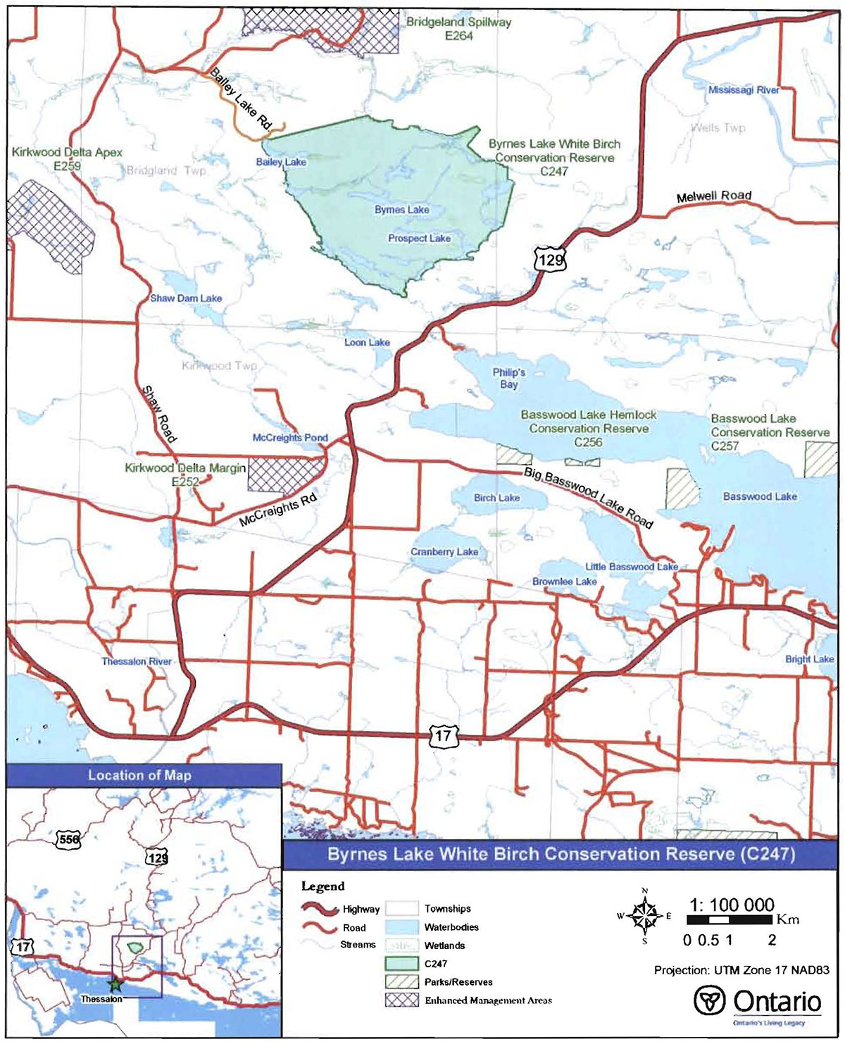
Byrnes Lake White Birch Conservation Reserve is located approximately 65 km east of the City of Sault Ste. Marie and 10 km north of the Town of Thessalon, in Bridgland and Wells Townships (see Figure 1). This site was regulated on December 7, 2002 and is 1,569 hectares in size. Table 1 summarizes the administrative details of the site.
Whenever possible, recognizable natural and cultural features, such as creeks, shorelines and old roads, have been used to delineate conservation reserve boundaries to facilitate on-the-ground identification (see Map 1, Appendix A). The south and west boundaries of the conservation reserve follow the shorelines of numerous unnamed creeks and lakes, allowing for easy recognition of these boundaries. Portions of the north and east boundaries are vectored (two reference points connected by a straight line), and may require more precise orientation tools (e.g. GPS) to determine the limits of the conservation reserve.
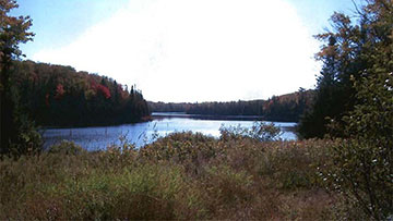
Byrnes Lake White Birch Conservation Reserve is a relatively isolated site. Primary access into the conservation reserve is by an ATV/snowmobile trail that originates from an access point off of Highway 129 and traverses north to Crockford’s Marsh (see Map 1, Appendix A). Site users can also gain entry to Bailey Lake (see Photo 1, Appendix B) through a rough, tertiary road that is accessible via the Shaw Road and Shellrock Loop Road (see Figure 1). The conservation reserve is mostly used mainly during the winter when the interior lakes can be easily accessed by snowmobile.
Figure 1: Site Location for Byrnes Lake White Birch Conservation Reserve.

Enlarge Figure 1: Site Location for Byrnes Lake White Birch Conservation Reserve.
Byrnes Lake White Birch Conservation Reserve is located within Site District1 5E-1 (Hills 1959), an ecological unit extending along the St. Marys River and the North Channel of Lake Huron, roughly from Gros Cap on Lake Superior eastward to the Spanish River. The conservation reserve is a regionally significant area that offers an assortment of vegetation-landform combinations (King et al. 2003). Although mixed stands of white birch, poplar (Populus sp.) and white pine (Pinus strobus L.) dominate the forest canopy of the site, a variety of other species such as red maple (Acer rubrum L.), sugar maple (Acer saccharum Marsh.) and eastern white cedar (Thuja occidentalis L.) also can be found.
The headwaters of tributaries into the Little Thessalon River and into Big Basswood Lake can be found within the site. These secluded lakes and streams offer opportunities for remote recreational activities. Additionally, Crockford’s Marsh, located south of Prospect Lake, and other wetlands add to the diversity of the site by providing habitat for an assemblage of animal and plant life. Photos of the conservation reserve can be found in Appendix B.
| Name | Byrnes Lake White Birch Conservation Reserve (C247) |
|---|---|
| Site Region - Site District (Hills 1959) | 5E-1 Thessalon |
| Ecoregion - Ecodistrict (Crins and Uhlig 2000) | 5E-1 |
| OMNR Administrative Region/District/Area | Northeast Region/Sault Ste. Marie District/Northshore Area |
| UTM co-ordinates | Zone 17 (NAD 83) 308750 E, 5139000 N |
| SCI Completed | January 30 2004 |
| Regulated | December 7, 2002 |
| Area | 1 569 ha |
| Nearest Town | Approximately 65 km east of the City of Sault Ste. Marie; approximately 10 km north of the Town of Thessalon |
| Township(s) | Bridg land and Wells |
| OBM Numbers | 2017310051400, 2017310051300, 2017300051400, 2017300051300 |
| Topographical Map Number I Name | 41J 5 Bruce Mines; 41 J 6 Iron Bridge |
| Wildlife Management Unit | 36 |
| Forest Management Unit | Northshore Forest |
4.2 History of the Site
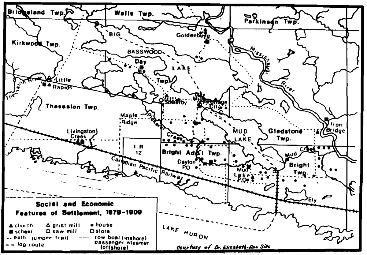
Although historical records and other reference materials specific to the area of Byrnes Lake White Birch Conservation Reserve are limited and vague, the landscape surrounding the site is known to have been an important source of timber for the pioneering settlements and lumber camps during the late 1800s and early 1900s. As illustrated in Figure 2, logging occurred in Bridgland and Wells Townships in the early 1900s and the harvested timber was transported to settlements at Little Rapids and Day Mills.
Figure 2: Settlements and routes along the North Shore of Lake Huron from 1879-1909 (Cameron 1993).

A jumper trail or corduroy road was used to transport timber to sawmills in Little Rapids (Cameron 1993). The trail was most likely utilized during the winter when the lakes, rivers and swamps were frozen. At the same time, log driving down the Little Thessalon River was also a very popular method for moving timber and required great skill and prowess. MacDonald (1966) recounts the legendary accomplishments and exploits of the lumbermen and log drivers of the Kirkwood area.
Also, timber was being towed by alligators 2 across Big Basswood Lake (historically known as Lake Wakwekobi) to be boomed at Day Mills. The logs were then sent down Bright Lake (historically known as Mud Lake) and boomed in Lake Huron, eventually to be hauled along the north shore to mills in the Town of Nestorville (Cameron 1993).
Intense forest fires are also thought to have played an important role in the formation of the conservation reserve’s landscape. Despite the fact that there is no known evidence of fire in the area since the 1920s, Bergsma (1998) indicates that the site is notable for fire regenerated white birch. Extreme fires in 1888 (Cameron 1993) that affected many forestry operations throughout the Kirkwood area may have also burnt some of the conservation reserve.
4.3 Inventories
Table 2 indicates the current status of natural heritage inventories that have occurred for Byrnes Lake White Birch Conservation Reserve. Recommendations for future inventory needs are located in Table 3, Section 7.2.
| Type of Inventory | Inventory Method | Date(s) of Inventory | Report |
|---|---|---|---|
| Life Science | Aerial reconnaissance | 9 Sept. 2002 | King, L. and S. Longyear. 2003. Byrnes Lake White Birch Conservation Reserve, Natural Heritage Area: Life Science Checksheet. Unpublished Information. Ontario Ministry of Natural Resources (in prep.). |
| Earth Science | Aerial reconnaissance | 9 Sept. 2002 | Kristjansson, F.J. 2003. Earth Science Checksheet for Byrnes Lake White Birch Conservation Reserve. Unpublished Information. Ontario Ministry of Natural Resources (in prep.). |
| Recreation | Ground and aerial reconnaissance | Ground: 15 Aug. 2002 07 Oct. 2003 Air: 9 Sept. 2002 |
Latulippe, T. & M. Hall. 2003. Recreation aerial Inventory Report for Byrnes Lake White Birch Conservation Reserve. Unpublished Information. Ontario Ministry of Natural Resources. |
5.0 State of the Resource
5.1 Key Values
Key values are those values that make this site unique and have led to its designation as a conservation reserve. Their protection is paramount. The key values found within Byrnes Lake White Birch Conservation Reserve include the following:
- Provincially significant representation of white birch dominated forest stands on moderately broken, shallow sandy till uplands
- Hydrologically significant headwater areas that contribute to local groundwater recharge and are tributaries of the Little Thessalon River and Big Basswood Lake
- Red oak (Quercus rubra L.) at the northern extent of its range
Additional values as listed in Section 5.2 through Section 5.6 are also important. Descriptions in this section are not necessarily complete. If new values, key or otherwise, are identified they will be added to this section. If any new value is considered significant, management guidelines may be modified, if required, to ensure its protection.
5.2 Earth Science Values
Byrnes Lake White Birch Conservation Reserve offers a rolling landscape of gentle hills with scattered rock outcroppings (see Figure 3). The conservation reserve is found within Site Region 5E, Georgian Bay and within Site District 5E-1, Thessalon (Hills 1959). Site Region 5E is composed of lowland areas of water-laid materials frequently broken by bedrock outcrops and upland areas of rolling bedrock covered to variable depths with materials ranging from gravel to silty sands (Crins and Uhlig 2000). Site District 5E-1 is characterized as a lowland area with pockets of lakelaid clay, silt and sand intermittently associated with areas of thinly covered bedrock and ridges of esker and morainic materials (Hills 1959).
Figure 3: Rock face along trail Into Crockford’s Marsh (J.Young. Oct. 7, 2003).
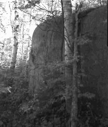
The bedrock geology of the site is Nipissing diabase (Kristjansson 2003). Kristjansson (2003) also indicates that the surficial geology of the conservation reserve is composed of three units: bedrock-drift complex; glacial-fluvial outwash; and, organic deposits. The majority of the site is comprised of bedrock-drift complex in the form of bedrock uplands and bedrockcontrolled lowlands. The northwest and northeast portions of the site have moderate bedrock exposure (approximately 40-50%); whereas, the central, southwest and southeast areas have moderate to major bedrock exposure (60-75%). Each of these areas is covered by a discontinuous till. Exposed bedrock surface area constitutes 65 hectares or 4.3% of the total surface area of the conservation reserve (King et al. 2003).
5.3 Life Science Values
Byrnes Lake White Birch Conservation Reserve is located in the Algoma section of the Great Lakes-St. Lawrence Forest Region, in ecological Site District 5E-1. This region is typified by a mid-humid, warm-boreal climate and supports a variety of tree communities, ranging from softwoods occupying the cool valleys to hardwoods associated with higher altitudes (Hills 1959, Rowe 1972). Drainage in this site district is generally to the west and southwest through pre-glacial valleys, some of which have been filled with deep glacial-fluvial material (Burkhardt et al. 2003).
The main forest communities within the conservation reserve are white birch, poplar and white pine dominant mixedwood3 stands (Burkhardt et al. 2003). Pure eastern white cedar and pure white pine stands are located in the Prospect Lake area (see Map 2, Appendix A). Red oak has established on the extensive rock barrens scattered over the conservation reserve. Most of the forest stands in the site are between 30 and 89 years old (see Map 3, Appendix A) at 61to 80% stocking 4, with stands of white pine and black spruce (Picea mariana [P. Mill.] B.S.P.) stocked at less than 40% and stands of white birch and sugar maple stocked at greater than 80% (King et al. 2003). There are no known significant old growth stands within the conservation reserve. A small (0.03 ha) old growth balsam fir (Abies balsamea L.) stand is located within the site on the eastern shore of Sucker Lake but, because of the size of the stand, does not contribute to the diversity of the site (King et al. 2003).
Byrnes Lake White Birch Conservation Reserve is considered to be a hydrologically significant headwater area. The northeastern portion of the site drains towards the Little Thessalon River and a series of lakes and creeks along the southwestern boundary flow into Phillips Bay on Basswood Lake. Byrnes and Prospect Lakes appear to be isolated drainage systems that may contribute to ground water recharge (Bergsma 1998). The conservation reserve falls within two tertiary watersheds of the Lake Huron Basin (OMNR 2002b). Approximately 75% of the conservation reserve’s boundary is composed of and/or adjacent to wetlands (King et al. 2003). Appendix B, Photo 7 depicts Crockford’s Marsh which forms part of the site’s southern boundary.
A variety of wildlife is associated with the many habitats of Byrnes Lake White Birch Conservation Reserve. Large mammals such as moose (Aices alces), white-tailed deer (Odocoileus virginianus) and black bears (Ursus americanus) are known to frequent the site. Waterfowl, including sandhill cranes (Grus canadensis), great blue herons (Ardea herodias) and wood ducks (Aix sponsa), have been observed within the site. Furthermore, a great blue heron nesting site is located within the conservation reserve. A number of sport fish are also found in many of the lakes, including lake trout (Salvelinus namaycush), rainbow trout (Oncorhynchus mykiss), and suckers (Catostomus spp). Fish stocking has occurred in Byrnes Lake (lake trout), Prospect Lake (rainbow trout) and Rainbow Lake (rainbow trout). A more detailed inventory of the conservation reserve and its wetlands is required to provide further information regarding species composition.
5.4 Recreational Values
Byrnes Lake White Birch Conservation Reserve is situated in a picturesque region of Ontario, and has the potential to offer a great mixture of recreational opportunities in a collage of settings. In relation to other conservation reserves in the Sault Ste. Marie District, Byrnes Lake White Birch is a large site with limited accessibility. Please refer to Section 4.1 for information on access. Currently, most of the recreational activity that occurs within the site takes place during the winter months when the interior lakes can be accessed by snowmobile.
Fishing is the primary recreational activity within the conservation reserve, occurring through the summer and winter months. During the winter months, Byrnes Lake and Prospect Lake are the main destinations for ice fishing (Latulippe and Hall 2003). Hunting and nature viewing are also activities known to take place in the conservation reserve. Other activities that exist or have potential within the site are photography and nature appreciation. However, the current absence of established hiking trails through the site limits the opportunity for recreational activities such as backcountry hiking and camping within the conservation reserve.
5.5 Cultural Values
This site falls within the Robinson-Huron Treaty area. To date, no First Nation community has identified any specific aboriginal values within this conservation reserve.
5.6 Research Values
Although the LUS (OMNR 1999) indicates that research on the growth of white birch, poplar and red maple stands has occurred within Byrnes Lake White Birch Conservation Reserve, government forest research plots are actually located just outside of the site.
5.7 Site Condition
Interpretation of aerial photographs and visits to the site indicate that disturbance within Byrnes Lake White Birch Conservation Reserve is minimal. Since the interior of the site is primarily used during the winter months (i.e. ice-fishing) and accessibility during the year is essentially through two areas (Crockford’s Marsh and Bailey Lake), there has been little human disturbance. Also, a large portion of the boundary of this conservation reserve follows water features, a natural boundary, thereby reducing the fracturing of the forest communities and providing better protection of the core values (King et al. 2003). Furthermore, the circular shape of the conservation reserve increases the relative size of the interior area to the length of the boundary, minimizing impacts of exterior disturbances on the core area of the site.
According to provincial fire history layers, Bergsma (1998) indicates that this site is notable for the fire regenerated white birch, although no known evidence of fire post dates the 1920s.
6.0 Management Guidelines
All management guidelines in this SCI are based on direction contained in the LUS (OMNR 1999) and associated policy clarification statements. The management guidelines outlined in this section are specific to Byrnes Lake White Birch Conservation Reserve and are intended to protect the site’s unique values. The guidelines in this document may be subject to change and may be amended as necessary. If a conflict between management guidelines exists, the conservation reserve will be managed to protect the integrity of its natural values, while permitting compatible land use activities (OMNR 1997a).
Proposed new uses and/or development, as well as research and education activities, will be reviewed on a case-by-case basis. Before new proposals can be permitted, the Test of Compatibility (Appendix C) must be passed as well as consideration of cultural values according to Conserving a Future for our Past: Archaeology, Land Use Planning & Development in Ontario, Section 3 (MCzCR 1997). In addition, all new proposals are subject to applicable Environmental Assessment Act (R.S.O. 1990, Chapter E.18) requirements.
The following management strategies have been devised to achieve the goal and objectives of the SCI for Byrnes Lake White Birch Conservation Reserve. A summary table of the management guidelines for this site can be found in Appendix D. For the most up to date version of this policy report, please refer to the Crown Land Use Atlas on the internet at http://crownlanduseatlas.mnr.gov.on.ca, or contact your local Ministry of Natural Resources office. The Crown Land Use Atlas is a consolidation of existing local land use policies for Crown lands within the OLL planning area, an area that covers 45 percent of the province and that extends from Lake Simcoe in the south to the Albany River in the north.
6.1 Industrial Activities
6.1.1 Commercial Timber Harvest
The area contained within this conservation reserve (1,569 ha) has been withdrawn from the Northshore Sustainable Forest License area and no commercial timber harvesting will be permitted. Please refer to Section 6.4.3 for information regarding non-commercial wood harvesting.
6.1.2 Mining and Exploration
There are no existing mining claims or leases within this conservation reserve. Mining and surface rights within the conservation reserve’s boundaries have been withdrawn from staking under the Mining Act (RSO 1990 Chapter M.14). Mineral exploration is not permitted.
6.1.3 Extraction of Peat, Soil, Aggregate and Other Material
Extraction of peat, soil,aggregate and other material is not permitted.
6.1.4 Energy Generation
Hydropower development and windpower generation are not permitted.
6.2 Existing and Proposed Development
6.2.1 Transportation Corridors
6.2.1.1 Roads
According to the LUS (OMNR 1999), new roads for resource extraction will not be permitted except for those identified in Forest Management Plans prior to March 31, 1999. No new or existing roads for resource extraction were identified.
6.2.1.2 Trails
Currently, no major organized summer or winter trails have been identified within the conservation reserve. A locally used ATV trail approaches the conservation reserve from the south but terminates at Crockford’s Marsh. This trail and extended trails receive more use during the winter months for snowmobiling, in order to gain access into Prospect Lake, Byrnes Lake and surrounding smaller lakes.
Any proposed new trails are subject to the Test of Compatibility (Appendix C) and applicable Ministry of Natural Resources' policies and procedures. Trail development should take into account the unique characteristics of this site and must be compatible with the site’s key values. All new and existing trail heads and trail routes must be recorded using new technologies (i.e. global positioning systems) to ensure an accurate record of the location of the feature. This location information must be provided to the Sault Ste. Marie District, Ministry of Natural Resources.
6.2.2 Other Corridor Development/Maintenance
No communication, energy transmission, or other non-road corridors are located within this conservation reserve. New corridor developments will be actively discouraged. Proposals for new corridors will be subject to the Test of Compatibility (Appendix C) and applicable Ministry of Natural Resources' policies and procedures.
6.2.3 Natural Heritage Appreciation Facilities/Recreational Structures
There are currently no existing authorized natural heritage appreciation facilities or recreational structures (ie. boardwalks, bird viewing platforms, kiosks, ski shelters, or interpretative signs). New natural heritage appreciation facilities and recreation structures are permitted, subject to the Test of Compatibility (Appendix C) and applicable Ministry of Natural Resources' policies and procedures.
6.2.4 Land Disposition
Sale of land is not permitted, except for those situations described in the policy clarification tables (OMNR 2000).
No Land Use Permits (LUPs) are currently issued within this conservation reserve. New leases or LUPs may be issued for approved public uses (ie. not for private recreation camps), subject to the Test of Compatibility (Appendix C) and applicable Ministry of Natural Resources' policies and procedures. These leases/permits will not be sold but may be eligible for enhanced tenure or transfer.
LUPs may be renewed or transferred, subject to normal screening criteria (see list below). While these LUPs cannot be sold, enhanced tenure can be considered subject to the Test of Compatibility (Appendix C) and applicable Ministry of Natural Resources' policies and procedures.
Enhanced tenure is defined as anything beyond the term and form of current tenure. All requests for transfer or enhanced tenure will be subject to the following screening criteria:
- Is the transfer or enhanced tenure consistent with the conservation reserve’s land use intent, which is the protection and enhancement of the site’s natural, recreational and cultural values?
- Is it consistent with the land disposition policies outlined in the District Land Use Guidelines, the Crown Land Use Atlas, this SCI and any other applicable document?
- Does it adversely affect the values as identified in Section 5.0, and/or conflict with other uses?
- Is land needed by the Crown to protect significant natural or recreational values outlined in this SCI?
- Does the transfer or enhanced tenure clash with traditional Aboriginal uses, land claims or agreements?
- Are all rents, taxes, fees, rates or charges paid up for the existing LUP or lease?
6.3 Commercial Activities
6.3.1 Commercial Bait Harvesting
Bridgland and Wells Townships are both currently allocated to commercial bait harvesting operations. New operations can be considered subject to the Test of Compatibility (Appendix C) and applicable Ministry of Natural Resources' policies and procedures.
Under Public Lands Act PL 3.03.08 -"Buildings for Bait Harvesting Management" (OMNR 2002a), cabins for the purposes of bait harvesting may be constructed on Crown land. However, such buildings should be avoided within this conservation reserve and established on Crown land outside of the protected area.
6.3.2 Commercial Fishing
There are currently no commercial fisheries. New operations may be considered subject to the Test of Compatibility (Appendix C) and applicable Ministry of Natural Resources' policies and procedures.
6.3.3 Commercial Fur Trapping
Registered Traptine Areas BL 008, BL 009 and BL 023 encompass the area of the conservation reserve. These registered trapline areas are currently allocated to head trappers. If a head trapper surrenders a registered trapline, or the head trapper’s privileges are revoked, the registered trapline may be transferred to another trapper following established allocation procedures. If the registered trapline is not transferred in due course, or remains unallocated for a significant period of time, reallocation of the trapline may occur following applicable district screening processes.
The establishment of new trapline trails will be considered following the procedure and criteria for new trails as outlined in Section 6.2.1.2. No trap cabins currently exist within Byrnes Lake White Birch Conservation Reserve. The establishment of new trap cabins will not be permitted.
6.3.4 Bear Management Areas
A portion of Bear Management Area (BMA) BL 36-023 covers this conservation reserve. Guided hunting activities associated with a BMA may continue. Transfer of the BMA within this conservation reserve may be permitted in cases where the current operator sells their bear hunting business to another operator and the BMA transfer is approved. If an operator surrenders the BMA or the BMA is revoked, reallocation of the BMA may occur following applicable district screening processes.
6.3.5 Commercial Food Collection
There are no existing commercial food harvesting ventures. Any new ventures requiring permits from the Ministry of Natural Resources will be subject to the Test of Compatibility (Appendix C) and applicable Ministry of Natural Resources' policies and procedures.
6.3.6 Commercial Non-Timber Forest Products
Commercial harvesting of non-timber forest products is not consistent with the intent of the conservation reserve and will not be approved.
6.3.7 Outpost Camps/Main Base Lodges
There are no existing authorized outpost camps or main base lodges. New outpost camps and main base lodges may be considered .through planning and will be subject to the Test of Compatibility (Appendix C) and applicable Ministry of Natural Resources' policies and procedures. The form of land tenure for these new uses will remain as a land use permit or lease. Sale of Crown land for new outpost camps or mainbase lodges will not be permitted.
6.4 Non-Commercial Activities
6.4.1 Nature Appreciation/Recreation Activities
Off-trail hiking, cross-country skiing, snowshoeing,and other non-motorized activities will be permitted within this conservation reserve. However, should the impact of these activities degrade the landscape, the Ministry of Natural Resources will re-evaluate these permitted uses and decide upon a new strategy for this site. New trails to support these activities may be considered. Please refer to Section 6.2.1.2 for more details related to trail development.
6.4.2 Camping
There are no maintained campsites or campgrounds within this conservation reserve. Crown land camping policies apply, unless significant adverse effects on protected values necessitate further planning and management for this activity. Existing campsites should be used where they exist and campers should avoid sensitive areas.
6.4.3 Non-Commercial Consumptive Resource Use
Cutting of trees for non-commercial purposes may be authorized via a permit issued by the local Ministry of Natural Resources, subject to review and determination of the impact that such cutting would have on the values identified in Section 5.0. Such permits are intended only for leaseholders, Land Use Permit holders, cottagers and other property owners within the conservation reserve who do not have road access to their property and have no alternate wood source outside of the conservation reserve. This permit is intended to cover fuelwood, dock stringers, and other occasional small scale uses.
Non-commercial harvesting of non-timber forest products such as berries and mushrooms can occur provided the values of the site, identified in Section 5.0, are not jeopardized.
6.4.4 Hunting and Fishing
Hunting is a trad!tional activity within this conservation reserve. In conjunction with current hunting regulations and conservation reserve policy, hunting is permitted to continue.
Recreational fishing is also permitted to continue in compliance with current fishing regulations.
6.4.5 ATV and Snowmobile Use
An ATV/snowmobile trail has been identified within the conservation reserve, although it is not formally part of the Ontario Federation of Snowmobile Clubs network. Please refer to Section 6.2.1.2 for more information on trails. In general, off-trail use of ATVs and snowmobiles is not permitted. However, off-trail use is permitted for licenced trappers to access their traplines and for licenced bait harvest operators to conduct bait harvest operations. Off-trail ATV and snowmobile use are also permitted for the direct retrieval of large game by hunters. In all these cases, off-trail use is only permitted provided the protection of the site’s values is not compromised. Should the impact of off-trail ATV and snowmobile use degrade the landscape, the Ministry of Natural Resources will re-evaluate these permitted uses and determine a new strategy.
6.5 Resource Management Activities
Resource management activities refer to those tools used to protect and enhance the values of this conservation reserve. Some management activities may require the use of intrusive techniques. Under normal circumstances, some of these techniques would not be permitted to occur in the conservation reserve; however, if they are found to be necessary, they may be applied under controlled conditions, to achieve a desired result. Infrastructure such as roads, trails and buildings may need to be constructed to support activities such as prescribed burns, forest regeneration, wildfire control, and insect and disease control. Activities described in this section will be deemed acceptable if the ultimate outcome is in compliance with the management intent for this conservation reserve.
6.5.1 Insect and Disease Control
This conservation reserve will be maintained in as natural a state as possible. Insect and disease control measures should only be considered if the identified values are significantly threatened.
6.5.2 Fire Management
The Ministry of Natural Resources recognizes fire as an essential process fundamental to the ecological integrity of conservation reserves. In accordance with existing conservation reserve policy and the Forest Fire Management Strategy for Ontario, forest fire protection will be carried out as on surrounding lands.
Whenever feasible, the Ministry of Natural Resources' fire program will endeavor to use "light on the land" techniques, which do not unduly disturb the landscape, in this conservation reserve. Examples of light on the land techniques may include limiting the use of heavy equipment or limiting the number of trees felled during the fire response efforts.
Opportunities for prescribed burning to achieve ecological or resource management objectives may be considered. These management objectives will be developed with public consultation prior to any prescribed burning, and will be reflected in the document that provides fire management direction for this conservation reserve. Plans for any prescribed burning will be developed in accordance with the Ministry of Natural Resources Prescribed Burn Planning Manual (OMNR 1997b) and the Environmental Assessment Act (R.S.O. 1990, Chapter E.18).
6.5.3 Fish and Wildlife Management
New fish and wildlife management activities may be considered but will require the approval of a separate fish/wildlife management plan, which must be referenced in this SCI or an amendment made to this SCI to include specific management prescriptions. New fish and wildlife management activities are also subject to the Test of Compatibly (Appendix C) and applicable Ministry of Natural Resources' policies and procedures.
6.5.4 Vegetation Management
New vegetation management activities may be considered but will require the approval of a separate vegetation management plan, which must be referenced in this SCI or an amendment made to this SCI to include specific management prescriptions. New vegetation management activities are also subject to the Test of Compatibly (Appendix C) and applicable Ministry of Natural Resources' policies and procedures.
6.5.5 Forest Renewal
Preference will be given to natural regeneration following any disturbance in the conservation reserve. In some cases, regeneration may be artificially assisted when it is deemed appropriate to mitigate against human disturbances (e.g. illegal occupation or trespass).
6.6 Research
Scientific research is encouraged, by qualified individuals or institutions, that contributes to a better understanding of the natural and cultural values protected by this conservation reserve or that advances the protection, planning and management of these values. The Sault Ste. Marie District Planner should be contacted for information on research and/or monitoring opportunities within this conservation reserve. Proposals to conduct research should be directed to the Northshore Area Supervisor, Ministry of Natural Resources, Blind River Area Office, and will be subject to the Test of Compatibility (Appendix C) and applicable Ministry of Natural Resources' policies and procedures. Any site that is disturbed during research activities is to be rehabilitated as closely as possible to its original condition. Collecting may only be permitted as part of an authorized research project and may be subject to appropriate permits and conditions.
Existing Forest Resource Inventory surveys and approved resource monitoring activities are permitted to continue.
6.7 Marketing
No active marketing of this conservation reserve is anticipated.
6.8 First Nations
Traditional activities and Aboriginal rights, as defined in the Robinson·Huron Treaty and other applicable legislation, will not be affected within or by the boundaries of this conservation reserve.
Any First Nation land claims within this area will be addressed according to appropriate Ministry of Natural Resources' procedures. When possible, the Ministry of Natural Resources will work with the Ontario Ministry of Culture to identify archaeological sites to be protected.
7.0 Recommendations
7.1 Additions to the Reserve
Since Byrnes Lake White Birch Conservation Reserve is surrounded by Crown lands, there is potential to expand the boundaries of the conservation reserve. The foremost recommendation is to extend the northern boundary to include a portion of the Bridgland Spillway Enhanced Management Area (EMA). This EMA (E264n) is centred on a series of abandoned river channels representing a former route (southern exit) of the Mississagi River from the Haughton Prairie into what is now the Little Thessalon River valley (Noble 1991). Noble (1991) further indicates that much of the area is now mixed wetland communities in an area dominated by dry sand plains. Expanding the boundary to incorporate the EMA would better protect the values of the spillway, as well as increase the core area and diversity of the conservation reserve.
Other potential additions to the conservation reserve could include expanding the boundaries south and west to the Shaw Dam Lake/Little Thessalon River and/or east to Highway 129. Boundary expansion should recognize that a large majority of the boundary currently follows water features, which provide both a natural break in forest communities as well as points of reference for on-the·ground identification of the site’s perimeter. Altering the boundary to follow cultural features such as Highway 129 or the Shaw Road, however, will create a buffer around wetland habitats adjacent to the conservation reserve and also help to better protect other core values within the site. Using existing roads as boundaries may also provide alternate access points and routes, which will facilitate and disperse future recreational use of the site.
7.2 Future Needs and Considerations
The values protected by the site should be considered in land use management activities on adjacent areas to ensure sufficient protection of the site’s core values. Table 3 highlights future needs and considerations for Byrnes Lake White Birch Conservation Reserve.
| Future Needs/Consideration | Details |
|---|---|
| Detailed Life Science Inventory | The Northeast Region should complete a gap analysis of the site using provincial data sets. This analysis should be used to review the landforms/vegetation information presented in this SCI and the life science checksheet to determine more fully the site’s significance and contribution to the parks and protected areas program. An analysis of the wetlands within and surrounding the conservation reserve should be completed. |
| Partnership Development | Efforts should be made to work with partners (such as the Ontario Forest Research Institute (OFRI), Sault College of Applied Arts and Technology) to gather baseline data on this site to assist with future monitoring and inspection activities. |
| Winter Recreation Assessment | Field visits should be made during the winter months to further assess the intensity of snowmobiling, ice-fishing and other winter recreation activities that do or may occur within the conservation reserve. |
| Boundary Marking | Although much of the site is delineated by natural features, the vectored boundaries of the conservation reserve should be marked to protect the site from adjacent land use activities. |
| Funding | Efforts should be made to obtain funding to support the above listed items, including monitoring, assessment, and inspection requirements for this site. |
7.3 Monitoring
Periodic monitoring of human activities and/or their impacts within this conservation reserve will be conducted. A schedule for cursory field monitoring will be identified within the District’s annual compliance plan and an Integrated Field Monitoring (IFM) inspection report will be filed at the Blind River Area Office. The Northshore Area Supervisor will oversee these activities. In addition, Conservation Officers will complete periodic compliance monitoring to ensure the protection mandate is maintained. If at any time human activities are deemed to be negatively impacting the protected features, the activities will be reviewed and measures taken to mitigate any disturbance.
Approved inventory, monitoring, assessment, or research activities that are compatible with protection objectives are encouraged. Any area that is disturbed during research activities is to be rehabilitated as closely as possible to its original condition. The Northshore Area Supervisor may apply additional conditions.
8.0 Implementation, Review and Revisions
8.1 Responsibility
The Blind River Area Team will be responsible for implementing the management policies and guidelines for Byrnes Lake White Birch Conservation Reserve (C266). The primary role will be to provide public information and compliance monitoring to ensure adherence to current policies and guidelines.
8.2 Review and Revisions
The Byrnes Lake White Birch Conservation Reserve SCI will be reviewed every five years by the District Planner to confirm and update the information in this document. Revisions to this document will be subject to requirements as specified in the Environmental Assessment Act (R.S.O. 1990, Chapter E.18). If changes in management direction are needed at any time, the significance of the changes will be evaluated. Minor amendments to the plan that do not alter the overall protection objectives may be considered and approved by the Area Supervisor without further public consultation. All minor amendments to the SCI will be documented in Appendix F. In assessing major amendments, the need for a more detailed Resource Management Plan (RMP) will first be considered. Where a RMP is not considered necessary or feasible, a major amendment to management direction may be considered with public consultation. Major amendments will be recommended by the District Manager and approved by the Regional Director, and will follow the appropriate guidelines (OMNR 2001).
Literature Cited
Bergsma, B. 1998. Life Science Gap Analysis for Site District SE-1. 251pp.
Cameron, E.M. 1993. Pioneers in a Land of Promise. Rae’s North Country Printing Services, Inc.: Iron Bridge, Ontario.
Crins, W.J. and P.W.C. Uhlig. 2000. Ecoregions of Ontario: Modification to Angus Hills' Site Regions and Site Districts- Revisions and Rationale.
Hills, G. A. 1959. A Ready Reference for the Description of the Land of Ontario and its Productivity. Preliminary Report. Ontario Department of Lands and Forests: Maple, Ontario.
King, L. and Longyear, S. and 2003. Byrnes Lake White Birch Conservation Reserve, Natural Heritage Area - Life Science Checksheet. Unpublished information. Ontario Ministry of Natural Resources.
Kristjansson, F.J. 2003. Earth Science Checksheet for Byrnes Lake White Birch Conservation Reserve. Unpublished information. Ontario Ministry of Natural Resources
Latulippe,T. and M. Hall. 2003. Recreation Inventory Report: Byrnes Lake White Birch Conservation Reserve. Unpublished information. Ontario Ministry of Natural Resources.
MacDonald, J.E. 1966. Shantymen and Sodbusters. Creative Printing House: Ontario.
Noble, T.W. 1991. Assessment of Natural Areas and Features for the Northern Portion of the Southern Boreal Forest Region, Site Region SE. Prepared for the Ontario Ministry of Natural Resources, Northeastern Region, Sudbury, Ontario. 57 pp. +appendices.
Noble, T.W. 1993. Site District SE-1 Gap Analysis. Ontario Ministry of Natural Reources report.
Ministry of Citizenship, Culture and Recreation. 1997. Conserving a Future for Our Past: Archeology Land Use Planning and Development in Ontario, Section 3.
Ontario Ministry of Natural Resources. 1992. Ontario Provincial Parks: Planning and Management Policies. 1992 Update.
Ontario Ministry of Natural Resource. 1997a. Conservation Reserves. Lands and Waters
Branch Policy. Public Lands Act, PL 3.03.05. Date Issued: February 11, 1997.
Ontario Ministry of Natural Resources. 1997b. Prescribed Burn Planning Manual. AFFMB Publication No. 313. Ontario Ministry of Natural Resources.
Ontario Ministry of Natural Resources. 2000. Conservation Reserve Policy-As Amended by the Ontario Living Legacy Land Use Strategy. Ontario Ministry of Natural Resources.
Ontario Ministry of Natural Resources. 1999. Ontario’s Living Legacy Land Use Strategy. Queen’s Printer for Ontario: Ontario, Canada.
Ontario Ministry of Natural Resources. 2001. Procedures for the Amendment of Ministry of Natural Resources Land Use Direction. Ontario Ministry of Natural Resources.
Ontario Ministry of Natural Resources. 2002a. Buildings for Bait Harvesting Management. Public Lands Act, PL 3.03.08.
Ontario Ministry of Natural Resources. 2002b. MNR districts and major basins of Ontario. R.S.O. 1990, Chapter E.18. Environmental Assessment Act. [Accessed: September 15, 2003] /laws/statute/90e18 .
R.S.O. 1990, Chapter M.14. Mining Act. [Accessed: September 15, 2003] /laws/statute/90m14 .
Thompson, J. 2001. Northeast Region Guidelines on the Planning Process for Conservation Reserves: Statements of Conservation Interest and Resource Management Plan. Unpublished information. Ontario Ministry of Natural Resources.
Appendix A: Byrnes Lake White Birch Conservation Reserve Maps
Map 1: Recreational Values of Byrnes Lake White Birch Conservation Reserve
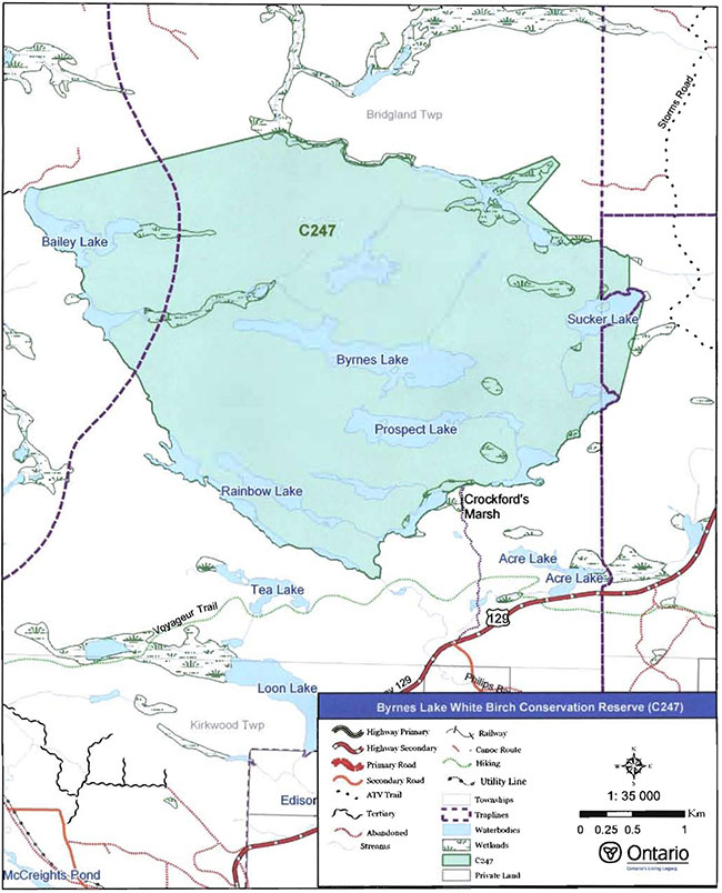
Enlarge Map 1: Recreational Values of Byrnes Lake White Birch Conservation Reserve
Map 2: Forest Communities in Byrnes Lake White Birch Conservation Reserve
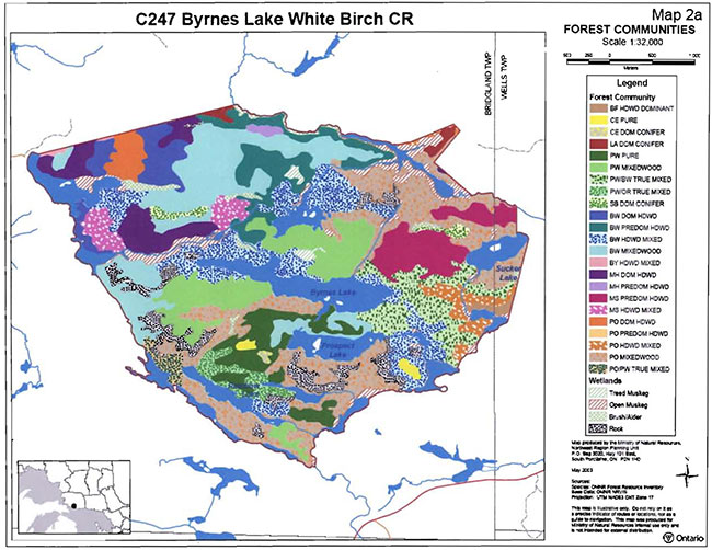
Enlarge Map 2: Forest Communities in Byrnes Lake White Birch Conservation Reserve
Map 3: Age Distribution of Tree Stands in Byrnes Lake White Birch Conservation Reserve

Enlarge Map 3: Age Distribution of Tree Stands in Byrnes Lake White Birch Conservation Reserve
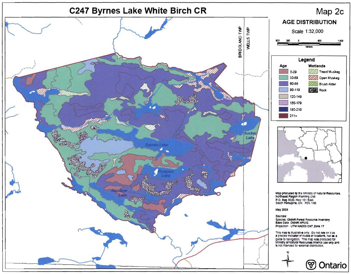
Appendix B: Byrnes Lake White Birch Conservation Reserve Photos
Photo1: White birch on rock outcropping.
(Photo taken by Joey Young during site visit, OMNR; Oct 7, 2003)
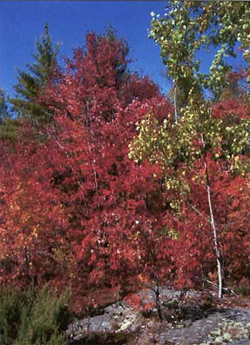
Photo 2: Creek into Crockford’s Marsh.
(Photo taken by Joey Young during site visit, OMNR; Oct 7, 2003)
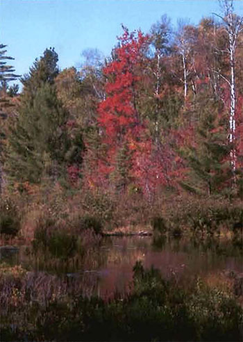
Photo 3: Burn scars on a tree stump.
(Photo taken by Joey Young during site visit, OMNR; Oct 7, 2003)
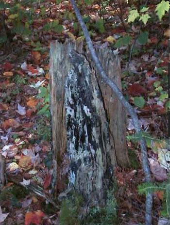
Photo 4: Mushrooms along ATV trail.
(Photo taken by Joey Young during site visit, OMNR; Oct 7, 2003)
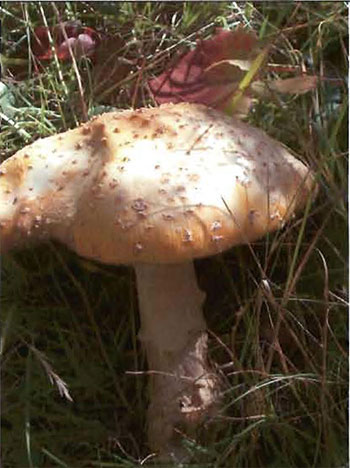
Photo 5: White Birch along shore of marsh.
(Photo taken Joey Young during site visit, OMNR; Oct 7, 2003)
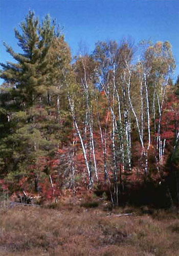
Photo 6: White Birch with rock outcropping.
(Photo taken Joey Young during site visit, OMNR; May 15, 2003)
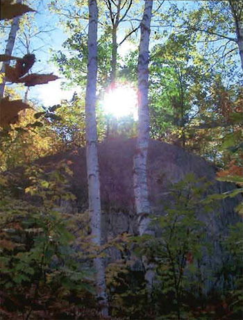
Photo 7: Bailey Lake.
(Photo taken Joey Young during site visit, OMNR; Oct 7, 2003)
Appendix C: Test of Compatibility
Test of Compatibility
The Conservation Reserve policy provides broad direction with regard to the permitted uses. The policy provides only an indication of the variety of uses that will be considered acceptable in conservation reserves. Any new uses, and commercial activities associated with them, will be considered on a case by case basis, and, subject to the following test of compatibility. To ensure a standard screening process is followed, reviews of all current and new activities will be subject to the screening criteria as specified by the Environmental Assessment Act (R.S.O. 1900, Chapter E.18).
The following outlines the two steps involved in performing a Test of Compatibility. An assessment of current activities would only follow step two, which focuses on the impacts. An assessment of any new activity would consider the impact of the activity and its conformity to the SCI/RMP.
-
Conformity to SCI/RMP: SCIdescribe values for which an area has been set aside and the range of appropriate uses that will be permitted in the area. SCImay also speak to the acceptability of other 'new' uses currently not occurring in the area.
The first 'test' is: "do proposed new land uses and/or commercial activities conform to the direction of the SCI/RMP for the conservation reserve? Would the new use(s) depart from the spirit of appropriate indicator land uses in the SCI/RMP?"
- Impact Assessment: If the proposed use(s) pass test 1 it is important to determine their impact on the area before they are approved. This should include the following:
- Impact on natural heritage values: "will the new use(s) impact any natural values in the area? If so how and to what degree? Is it tolerable?"
- Impact on cultural values: "will the new use(s) impact an historical or archaeological values in the area?"
- Impact on research activities: "will the new use(s) affect research activities in the area?"
- Impact on current uses: "will the new use(s) have any negative impact on the array of current uses?"
- Impact on area administration: "will the new use(s) increase administrative costs and/or complexity?" (For example, the cost of area monitoring,security and enforcement).
- Impact on accommodating the use outside the conservation reserve: "Could the use(s) be accommodated as well or better outside the conservation reserve?"
- Impact on socio-economics of the area: "will the new use(s) affect the community(ies) surrounding the area in a positive or negative way?" (For example, will the new use make an area less remote thereby affecting a local tourism industry that is dependent on the area’s remoteness for its appeal?"
- Impact on area accessibility: "does the new use(s) give someone exclusive rights to the area or a portion of the area to the exclusion of other existing uses?"
Appendix D: Summary of Permitted Uses
The following Policy Report was obtained from the Crown Land Use Atlas website during completion of this SCI (fall 2003). Changes may have been made to this policy report since that time. For the most recent version of this policy report, please refer to the Crown Land Use Atlas on the Internet at http://crownlanduseatlas.mnr.qov.on.ca or contact your local Ministry of Natural Resources office.
Ministry of Natural Resources
Ontario
Crown Land Use Atlas- Policy Report
Identification:
lD: C247
Area Name: Byrnes Lake White Birch
Area (ha): 1569
Designation: Conservation Reserve (Ontario’s Living Legacy)
District(s): Sault Ste. Marie
Description:
This conservation reserve, in Site District SE-1 has a mixture of low to mildly rolling landforms, including hills covered in shallow sandy till deposits, lake-deposited sands, silts and clays and bedrock barrens. The white birch, poplar and red maple forests are part of an ongoing research study on forest growth.
Byrnes Lake White Birch was regulated as a conservation reserve on December 7, 2002.
Land Use Intent:
Statement of conservation interest to provide for ongoing research. Research must be consistent with the protection of natural heritage values.
Management of this area is also governed by the general policies contained in the Land Use Strategy (1999).
Management Direction:
Those uses and management activities not listed in the following table are governed by existing conservation reserve policy. Over time the management direction will be elaborated in a Statement of Conservation Interest or Resource Management Plan. Any new uses, and commercial activities associated with conservation reserves, will be considered on a case by case basis, and they must pass a test of compatibility to be acceptable. Compatibility is normally determined through a planning process.
Commercial activities
| Activity | Permitted | Guidelines |
|---|---|---|
| Aggregate Extraction | No | |
| Bait Fishing Existing: | Yes | Existing use permitted to continue, unless there are significant demonstrated conflicts. |
| Bait Fishing New: | Maybe | New operations can be considered, subject to the "test of compatibility" |
| Commercial Fishing Existing: | Yes | Existing use permitted to continue, unless there are significant demonstrated conflicts. |
| Commercial Fishing New: | Maybe | New operations can be considered, subject to the "test of compatibility". |
| Commercial Fur Harvesting Existing: |
Yes | Existing use permitted to continue, unless there are significant demonstrated conflicts. Existing trap cabins can continue; new cabins are not permitted. |
| Commercial Fur Harvesting New: |
Maybe | New operations can be considered, subject to the "test of compatibility". |
| Commercial Hydro | No | |
| Commercial Timber Harvest |
No | |
| Commercial Tourism Existing: | Yes | Existing authorized facilities can continue, unless there are significant demonstrated conflicts. |
| Commercial Tourism New: | Maybe | New tourism facilities can be considered during the planning for an individual reserve. |
| Bear Hunting by Non residents (guided) Existing: | Yes | Existing authorized operations permitted to continue. |
| Bear Hunting by Non residents (guided) New: | No | New operations not permitted. |
| Outfitting Services Existing: | Yes | Existing authorized operations permitted to continue. |
| Outfitting Services New: | Maybe | New operations can be considered during the planning for an individual reserve. |
| Outpost Camps Existing: | Yes | Existing authorized facilities permitted to continue. |
| Outpost Camps New: | Maybe | New facilities can be considered during the planning for an individual reserve. |
| Resorts/lodges Existing: | Yes | Existing authorized facilities permitted to continue. |
| Resorts/lodges New: | Maybe | New facilities can be considered during the planning for an individual reserve. |
| Boat Caches (managed) energy transmission and communications corridors Existing: | Yes | These facilities should avoid conservation reserve lands wherever possible. |
| Boat Caches (managed) energy transmission and communications corridors New: | No | |
| Food Harvesting (Commercial) Existing: | Maybe | |
| Food Harvesting (Commercial) New: | Maybe | |
| Mineral Exploration and Development | No | |
| Peat Extraction | No | |
| Wild Rice Harvesting | No | |
| Wild Rice Harvesting Existing: | Yes | |
| Wild Rice Harvesting New: | Maybe |
Land and resource management activities
| Activity | Permitted | Guidelines |
|---|---|---|
| Crown Land Disposition Private Use: | Maybe | |
| Crown Land Disposition Commercial Use: | Maybe | Sale of lands is not permitted, except for minor dispositions in support of existing uses (e.g. reconstruction of a septic system). Renewals of existing leases and land use permits are permitted. Requests for transfer of tenure will be considered in the context of the Statement of Conservation Interest or Resource Management Plan. New leases or land use permits permitted for approved activities. Tourism facilities can apply to upgrade tenure from LUP to lease. |
| Fire Suppression | Yes | Fire suppression policies are similar to adjacent Crown lands, unless alternative fire policies have been developed through a planning process. |
| Fish Habitat Management | Maybe | |
| Fish Stocking | Maybe | Conservation Reserve policy indicates that "featured species management" may be permitted. |
| Insect/disease Supperession | Maybe | |
| Inventory/Monitoring | Yes | |
| Prescribed Burning | Maybe | |
| Roads (Resource Access) Existing: | Yes | Existing roads can continue to be used. Continued use will include maintenance and may include future upgrading. |
| Roads (Resource Access) New: | Maybe | New roads for resource extraction will not be permitted, with the exception of necessary access to existing forest reserves for mineral exploration and development. |
| Vegetation Management | Maybe | Conservation Reserves policy indicates that Featured Species Management and Natural Systems Management may be permitted. Vegetation management can be considered in a planning process. |
| Wildlife Population Management | Maybe |
Science, education and heritage appreciation
| Activity | Permitted | Guidelines |
|---|---|---|
| Collecting | No | |
| Historical Appreciation | Yes | |
| Nature Appreciation | Yes | |
| Photography and Painting | Yes | |
| Research | Yes | |
| Wildlife Viewing | Yes |
Recreation activities and facilities
| Activity | Permitted | Guidelines |
|---|---|---|
| All Terrain Vehicle Use On Trails: | Yes | Existing use permitted to continue where it does not adversely affect the values being protected. |
| All Terrain Vehicle Use Off Trails: | No | ATV use off trails is not permitted except for direct retrieval of game. |
| Campgrounds | Maybe | |
| Food Gathering | Yes | |
| Horseback Riding (trail) | Yes | Existing use on trails permitted. |
| Hunting | Yes | |
| Mountain Bike Use | Yes | Existing use on trails permitted. |
| Motor Boat Use Commercial: | Yes | |
| Motor Boat Use Private: | Yes | |
| Non-motorized Recreation Travel | Yes | |
| Private Recreation Camps (Hunt Camps) Existing: | Yes | Existing camps permitted to continue, and may be eligible for enhanced tenure, but not purchase of land. |
| Private Recreation Camps (Hunt Camps) New: | No | |
| Rock Climbing | Maybe | |
| Snowmobiling On Trails: | Yes | |
| Snowmobiling Off Trails: | No | Except for the direct retrieval of game. |
| Sport Fishing | Yes | |
| Trail Development Existing: | Yes | |
| Trail Development New: | Maybe | Development of trails for a variety of activities (e.g. hiking, cross-country skiing, cycling, horseback riding, snowmobiling) can be considered as part of planning for an Individual reserve. |
Note: The policies outlined in this table do not supersede any Aboriginal or treaty rights that may exist, or other legal obligations.
Management of this conservation reserve is carried out within the context of Conservation Reserve policy as amended by the policies for new conservation reserves outlined in the Ontario’s Living Legacy Land Use Strategy.
Source of Direction:
Ontario’s Living Legacy Land Use Strategy (1999)
Conservation Reserves Policy (1997)
Blind River District Land Use Guidelines (1983)
Appendix E: Regulation Public Consultation Material
Note that some information in these materials is no longer current- the documents are provided here as a matter of historical record.
September 1, 2000
To: Ontario Living Legacy Stakeholders
Dear Sir/Madam:
On July 16, 1999, the Ontario Government released the Ontario’s Living Legacy Land Use Strategy, a broad land use approach to the planning and management of much of the Crown lands in central and parts of northern Ontario. A major part of the Ontario’s Living Legacy Land Use Strategy was a government commitment to the biggest expansion of provincial parks and conservation reserves in Ontario’s history. Ontario intends to add 378 new areas to its protected areas system. Ontario’s Living Legacy is a momentous achievement that will be recognized around the world as a significant contribution to sustaining our natural environment. A copy of the Land Use Strategy is available from our office upon request.
In accordance with the recommendations in the Land Use Strategy, the Ministry of Natural Resources is now implementing the process of establishing these 378 new protected areas. The first step in this process is for the Ministry to consult on the boundaries of these areas. In November 1999, MNR held boundary consultations on 64 sites across the OLL Planning Area. Eight of these sites were within Sault Ste. Marie District. At this time, Sault Ste. Marie District has prepared 19 more sites for boundary refinement consultation. Adjacent Districts are consulting an additional two sites, which are also partially contained within Sault Ste. Marie District, on. In future years, the remaining recommended protected areas from the Land Use Strategy will be put forward for similar consultations.
As stated in the Land Use Strategy, the boundary refinement process will consider local ecological information and will attempt to establish regulated boundaries along features that can be identified on the ground. The boundary refinement process may result in modest increases or decreases in the sizes of the protected areas. Any existing commitments for the areas, which were considered during the land use planning process, will be considered in defining the final boundary.
Following is a list of the 21 sites in SSM District scheduled for boundary consultation this year. These sites include both provincial parks and conservation reserves. The Land Use Strategy established the Ministry’s intent to add these Crown lands to Ontario’s protected areas system, following the extensive public consultation associated with Ontario’s Living Legacy and the Lands for Life land use planning initiatives between 1997 and 1999. The Ministry is inviting public comment on the proposed boundaries of these protected areas prior to their finalization and ultimate regulation under the Provincial Parks Act or the Public Lands Act.
C227 - Glen Crombie Conservation Reserve
P238 - Mississagi River Provincial Park Additions
C243 - Wagong Lake Forest Conservation Reserve
C244 - Rawhide Lake Conservation Reserve
C246 - Echo River Hardwoods Conservation Reserve
C247 - Byrnes Lake White Birch Conservation Reserve
P253 - Goulais River Provincial Park
C256 - Basswood Lake Hemlock Conservation Reserve
C258 - Thessalon River Delta I Rock Lake Red Oak Conservation Reserve
C260 - Rose Lake Dune Peatland Complex Conservation Reserve
C262 - Stuart Lake Wetland Conservation Reserve
P273 - Algoma Headwaters Provincial Park
P274 - Wenebegon River Provincial Park
P277 - Aubinadong - Nushatogaini Rivers Provincial Park
P278 - Pancake Bay Provincial Park Additions
P282 - Batchawana River Provincial Park
P285 - Sandy Islands Provincial Nature Reserve
C289 - Searchmont South Forest Conservation Reserve
C291 - Goulais River Beach Ridges Conservation Reserve
P292 - Lake Superior Provincial Park Additions
C307- Ile Parisienne Conservation Reserve
Your name and address have been included within a Ministry mailing list of persons potentially interested in these boundary consultations. The mailing list includes a range of individuals and groups, such as nearby landowners, resource users, persons with other rights or tenure (e.g. land use permit, Mining Act rights), municipalities, and others who may have an interest in the area. Accompanying this letter, you will find background information (factsheets, maps) for the site(s) we have determined to be of interest to you. More detailed maps and information about the proposed boundaries for all 21 sites are available from this office, or from the Blind River Area Office, 62 Queen Ave., Blind River.
In the future and subject to the intended regulation of these areas as provincial parks and conservation reserves, Ontario Parks and the Ministry of Natural Resources will undertake a management planning process to determine the long-term management of these protected areas. Depending upon the complexity of issues related to the provincial parks, management planning may take the form of a simple Interim Management Statement or a more detailed Park Management Plan. In the case of planning for conservation reserves, a simple Statement of Conservation Interest or a more detailed Resource Management Plan will result. Please let us know if you would like to be notified when planning begins.
Planning, management and permitted uses within these provincial parks and conservation reserves would be consistent with the commitments of the Ontario’s Living Legacy Land Use Strategy.
The Ministry is collecting comments and information regarding these proposed provincial park and conservation reserve boundary reviews under the authority of the Provincial Parks Act and the Public Lands Act respectively. These comments will assist the Ministry in making decisions and determining further public consultation needs. Comments and opinions will be kept on file and may be included in study documentation that is made available for public review. Under the Freedom of Information and Protection of Privacy Act (1987), personal information will remain confidential unless prior consent is obtained. However, the Ministry may use this information as public input on other resource management surveys or projects. For further information regarding this Act, please contact Paul Glassford, A/Information Management Supervisor, Ministry of Natural Resources, Sault Ste. Marie District (705-949-1231).
If you would like to discuss the proposed boundaries and the protection of these areas under the Provincial Parks Act and/or the Public Lands Act, please contact Erin Nixon, District Planner, Ministry of Natural Resources, 64 Church Street, Sault Ste. Marie, Ontario, P6A 3H3; telephone 705-949-1231ext. 247, fax 705-949-6450, by October 6, 2000. Further information on Ontario’s Living Legacy is available in our office or by visiting the Ministry’s internet website at www.mnr.gov.on.ca/MNR/oll/. (link no longer active)
Thank you for your interest.
Yours sincerely,
Dick Hagman
A/District Manager
Sault Ste. Marie District
DH/sw Attachments -
Provincial Park and/or Conservation Reserve Factsheet(s)
Proposed Site Boundary Map(s)
Key Map
Permitted Uses Table(s) for Provincial Parks and/or Conservation Reserves
On peut obtenir la version fran aise de la presente lettre en s'adressant au bureau du MRN le plus proche, a l'adresse ou au numero de telephone ci-dessous.
Byrnes Lake White Birch Conservation Reserve (C247) Fact Sheet
August, 2000
Background
On July 16, 1999, the Ontario Government released the Ontario’s Living Legacy Land Use Strategy to guide the planning and management of Crown lands in central and parts of northern Ontario. A major part of the Ontario’s Living Legacy Land Use Strategy was a government intent to establish 378 new protected areas. This commitment marks the biggest expansion of provincial parks and conservation reserves in Ontario’s history.
The proposed Byrnes Lake White Birch Conservation Reserve is part of this significant expansion of Ontario’s protected areas system.
Size and Location
The Byrnes Lake White Birch Conservation Reserve is located approximately 10 km north of Thessalon. It comprises some 1,569 ha primarily in Bridgeland township but extending as well into Wells township. It is situated west of Highway 129, and is centered on Byrnes and Prospect Lakes.
Area Highlights
The Byrnes Lake White Birch Conservation Reserve is located within ecological site district 5E-1, which extends from Sault Ste. Marie to Spanish along the St. Mary’s River and Lake Huron shoreline and inland for approximately 25 km. This site district is characterized by coastal landscapes of lacustrine plains interrupted only by small bedrock knolls, and inland by bedrock controlled, till-covered uplands. Natural vegetation communities that develop within this area combine species from both Great Lakes/St. Lawrence and Boreal forest regions.
The Byrnes Lake White Birch Conservation Reserve, recommended as a provincially significant area, offers the best representation of white birch dominated stands on moderately broken, shallow sandy till uplands. Red oak, which is at the northern extent of its range in this area, is established on the site’s extensive rock barrens. Even-aged stands of white birch and poplar predominate the area and are likely an early successional stage following a major disturbance by fire or harvesting. Research studies examining the growth patterns of white birch, trembling aspen and red maple are ongoing in the area.
The Byrnes Lake White Birch Conseravtion Reserve is hydrologically significant as a headwater area. Streams that flow into the Little Thessalon River and into Basswood Lake originate within this conservation reserve. Byrnes and Prospect Lakes appear to contribute to local groundwater recharge.
Land Use Intent
Conservation reserves are areas of Crown land set aside by regulation under the Public Lands Act.
Conservation reserves complement provincial parks in protecting representative natural areas and special landscapes. Most recreational (e.g. hiking, skiing, tourism related uses, nature appreciation) and non-industrial (e.g. fur harvesting, commercial fishing and bait harvesting) activities that have traditionally been enjoyed in the area will continue, provided that these uses do not impact on the natural features needing protection. Hunting and fishing are also permitted within all new conservation reserves recommended through Ontario’s Living Legacy.
Commercial timber harvesting, mining, aggregate extraction and commercial hydroelectric development are prohibited in conservation reserves. Careful mineral exploration may occur in specific new conservation reserves proposed through Ontario’s Living Legacy, in areas that have provincially significant mineral potential. If a portion of a new conservation reserve is to be developed for a mine, it would be removed from the reserve, and appropriate replacement lands would be placed in regulation. Please refer to Table 4 from the Land Use Strategy for a detailed summary of permitted uses in conservation reserves.
Next Steps
The Land Use Strategy established the Ministry’s intent to add these Crown lands to Ontario’s protected areas system, following the extensive public consultation associated with the Ontario’s Living Legacy and Lands for Life land use planning initiatives between 1997 and 1999. Prior to the finalization of the boundary of this conservation reserve proposed for regulation under the Public Lands Act, the Ministry is inviting public comment on the proposed boundary from all potentially affected stakeholders and First Nations from August 15 to September 15, 2000.
In the interim, the area has been withdrawn and protected from resource extraction activities such as timber harvesting, hydroelectric development, aggregate extraction and new mineral exploration.
In the future and subject to the intended regulation of the area as a conservation reserve, the Ministry of Natural Resources will prepare a long term management plan for this area. Depending upon the complexity of issues within this conservation reserve, management planning may take the form of a simple Statement of Conservation Interest or a more detailed Resource Management Plan. Please let us know if you would like to be notified when planning begins.
Planning, management and the uses permitted within this conservation reserve will be consistent with the commitments of the Ontario’s Living Legacy Land Use Strategy.
For More Information
For further information on the proposed Byrnes Lake White Birch Conservation Reserve, please contact Erin Nixon, District Planner, Ministry of Natural Resources, Sault Ste. Marie District ( 705-949-1231 ext. 247). You may also visit the Ministry’s Internet website at www.mnr.gov.on.ca/MNR/oll (link no longer active) for information about Ontario’s Living Legacy.
Appendix F: Amendments to the SCI
1 Ecological site districts are areas characterized by physiographic similarities, and by the successional trends exhibited by the predominant vegetation types on those physiographic features.
2 An "alligator" was a steam powered, flat bottomed tugboat used for towing massive amounts of logs across large lakes. These amphibious boats usually had twin propellers and cabins for housing the crew (Cameron 1993).
3 Mixedwoods are defined as follows: hardwood mixedwoods are stands dominated by hardwoods with less than 30 percent cover conifer in the main canopy (vice versa for conifer mixedwoods); mixedwoods contain approximately equal percentages of conifer and hardwood trees; and true mixedwoods contain a 50:50 split between conifers and hardwoods (Nicholson et al. 2003).
4 Stocking is defined as follows: a qualitative measure of the density of tree cover in a forest stand. Stocking represents the density of forest stems based on average age, height, and the working group (the dominant tree species) in a forest stand. (OMNR 2001).