Cardwell Township Old Growth Conservation Reserve Management Statement
This document provides policy direction for the protection, development and management of the Cardwell Township Old Growth Conservation Reserve and its resources.
Ministry of Natural Resources
Parry Sound District
Prepared with the assistance of:
Meteek & Company
Huntsville, Ontario
March 2005
Approval Statement
We are pleased to approve this Statement of Conservation Interest for Cardwell Township Old Growth Conservation Reserve (C89).
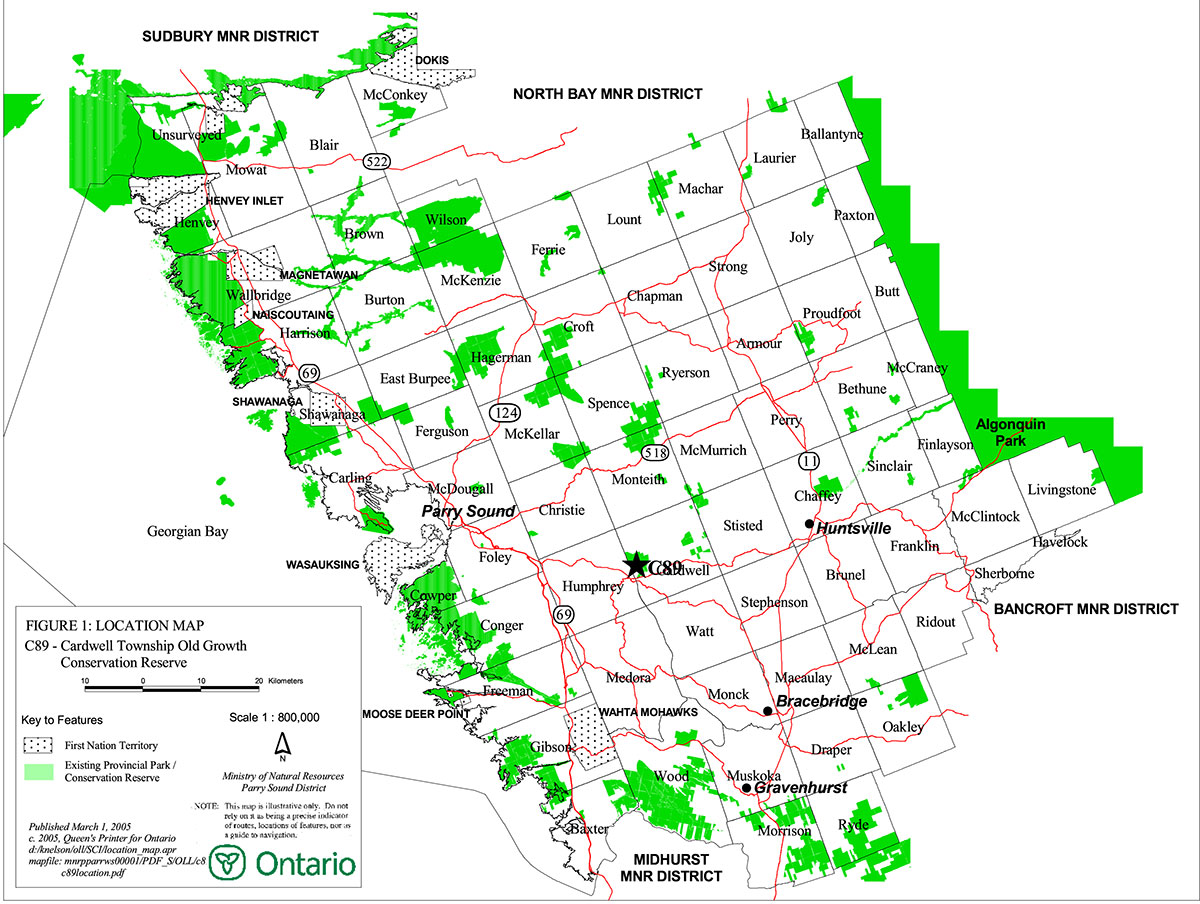
Cardwell Township Old Growth Conservation Reserve consists of 1029 hectares of Crown land, located about ½ kilometre northeast of the village of Rosseau. It lies in the western part of Cardwell Ward in the Township of Muskoka Lakes within the District Municipality of Muskoka. Portions of its boundary abut against privately owned lands, which are not part of this conservation reserve.
This conservation reserve, located in Hills' ecological Site District 5E-8, protects a large forested area with components of older white pine. Some of the white pine are relatively large, reaching a diameter of 60 to 75 centimetres at breast height (dbh) and are approximately 100 to 120 years old (in 2004). The area is actively used for hunting and angling, and Woods Lake, on its south boundary, is used for water-skiing.
Cardwell Township Old Growth Conservation Reserve is one of 378 new protected areas approved through Ontario’s Living Legacy Land Use Strategy, aimed, in part, at completing Ontario’s system of parks and protected areas.
During the "Lands for Life" planning process, the public was widely consulted and provided valuable input into what became Ontario’s Living Legacy Land Use Strategy. Comments received during that time, and during consultation related to the formal Public Lands Act regulation of the boundaries of this conservation reserve, were generally supportive of the protection of this area. Stakeholders who provided comment during the earlier consultation for this site were subsequently consulted regarding the draft Statement of Conservation Interest and any comments were considered in the finalization of this document.
This Statement of Conservation Interest provides guidance for the management of the conservation reserve and provides the basis for the ongoing monitoring of activities. More detailed direction is not anticipated at this time. Should more complex resource management or conservation issues arise or significant facility development be considered, then a detailed Resource Management Plan will be prepared with full public consultation.
Cardwell Township Old Growth Conservation Reserve is managed under the direction of the District Manager and the Bracebridge Area Supervisor of the Ministry of Natural Resources, Parry Sound District.
Approved by:
R. Griffiths District
Manager Parry
Sound District
Approved by:
Ron Running
Regional Director
Southern Region
Figure 1: Location of Cardwell Township Old Growth Conservation Reserve

Enlarge Figure 1: Location of Cardwell Township Old Growth Conservation Reserve
Figure 2: Site Map – Cardwell Township Old Growth Conservation Reserve
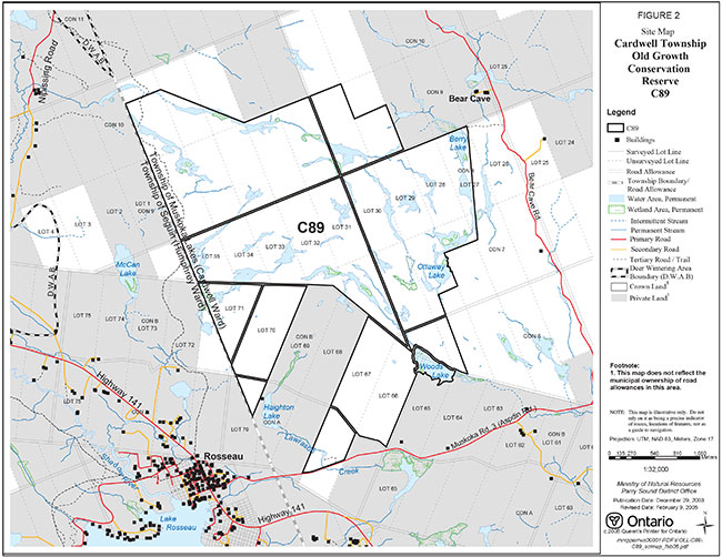
Enlarge Figure 2: Site Map – Cardwell Township Old Growth Conservation Reserve
1.0 Introduction
Ontario’s Living Legacy, the result of an extensive planning process that began in early 1997, culminated in the approval in July 1999 of a Land Use Strategy that identifies the intended strategic direction for Crown land in central and northern Ontario, including the completion of Ontario’s system of parks and protected areas. This process, which included public consultation, resulted in the recommendation for regulation of 378 new protected areas, including Cardwell Township Old Growth Conservation Reserve (C89).
Cardwell Township Old Growth Conservation Reserve consists of 1029 hectares of Crown land, located about ½ kilometre northeast of the village of Rosseau. It is in western Cardwell Ward in the Township of Muskoka Lakes within the District Municipality of Muskoka. Portions of its boundary abut privately owned lands, which are not part of this conservation reserve.
Cardwell Township Old Growth Conservation Reserve provides representation of older white pine forests in Hills' ecological Site District 5E-8, as well as a variety of other habitats including numerous small beaver- controlled lakes and ponds, thicket swamps, fens, meadow marshes, extensive gneissic rock barrens and forests dominated by red oak, red maple, sugar maple, yellow birch and aspen species. It is part of a large roadless natural area with Bear Cave Road, Muskoka Road 3 and Highway 141 a short distance away.
Very few trails penetrate this area, and use of the conservation reserve for hunting and angling is concentrated on its periphery. With the exception of a water-ski slalom course on Woods lake, on the southeast edge of this conservation reserve, most use of the site reflects its back-country, undeveloped nature.
Conservation reserves are established under the authority of the Public Lands Act, Ontario Regulation 805/94. Cardwell Township Old Growth Conservation Reserve was established by Ontario Regulation 148/02 on May 8, 2002.
A Statement of Conservation Interest is prepared under the direction of Procedural Guideline A – Resource Management Planning (PL. Procedure 3.03.05). The purpose of this Statement of Conservation Interest is to identify and describe the values of Cardwell Township Old Growth Conservation Reserve. The Statement of Conservation Interest also outlines the activities that currently occur within the conservation reserve and provides guidelines for the management of current and future activities in the context of protecting the natural, recreational and cultural values.
1.1 Background Information:
| Name | Cardwell Township Old Growth Conservation Reserve (C89) |
|---|---|
| Site Region/District | Georgian Bay Site Region, Site District 5E-8 |
| OMNR Administrative Region/District/Area | Southern Region/ Parry Sound District/ Bracebridge Area |
| Total Area (ha.) | 1029 hectares |
| Regulation Date | May 8, 2002 (O. Reg. 148/02) |
| First Nations | Robinson-Huron Treaty and Williams Treaty |
| OBM map sheets | 10 17 6050 50100, 6050 50150 |
| Topographic Map | Orrville 31 E/5 |
| UTM co-ordinates | 17T 60840 501610 (Centroid) |
1.2 Representation
Earth Science Representation:
Bedrock - Felsic and subordinate mafic gneisses of possibly metaplutonic protolith, and younger pegmatite of the Rosseau Domain, Algonquin Terrane in the southern part of the Central Gneiss belt of the Proterozoic Grenville Province.
Surficial - Variable depths of glacial till, and low relief bedrock barrens interspersed with numerous small lakes and wetlands with organic deposits are typical components of the Quaternary Era in southern Ontario.
Life Science Representation:
Cardwell Township Old Growth Conservation Reserve provides representation of older white pine forests in Hills' ecological Site District 5E-8, as well as a variety of other habitats including numerous small beaver- controlled lakes and ponds, thicket swamps, fens, meadow marshes, extensive gneissic rock barrens and forests dominated by red oak, red maple, sugar maple, yellow birch and aspen species.
Cultural Resources Representation:
Neither detailed cultural research nor inventory has been carried out for this conservation reserve.
Recent regional evaluation (OMNR, 2003) shows that this conservation reserve contains areas that have a high potential for cultural heritage sites.
Recreational Opportunities:
A recreational inventory report was prepared for this site based on existing knowledge and data sources of MNR staff, and site visits (Gavel, 2003). This site is recognized as providing wilderness type recreation opportunities. It accommodates big game hunting, hiking, water-skiing, angling and possibly waterfowl hunting.
1.3 Survey Work
| Survey Level | Earth Science | Life Science | Cultural | Recreational | Other |
|---|---|---|---|---|---|
| Reconnaissance | Duba & Frey, 2000 | Jalava, 2003 | OMNR, 2003 | Gavel, 2003 | None |
| Detailed | None | None | None | None | None |
| Requirement | None | Monitor the status/presence of significant species and associations. | Research to be encouraged | Monitor use impacts | None |
2.0 Values to be protected
The conservation reserve is located entirely within Hills' (1959) ecological Site District 5E-8. Values include earth science, life science and recreational/aesthetic values, with an emphasis on the life sciences.
2.1 Earth Science:
(Earth science information, unless otherwise noted, is taken from Duba & Frey, 2000)
Bedrock:
Cardwell Township Old Growth Conservation Reserve is an area of extensive bedrock barrens interspersed with numerous small lakes and wetlands. The bedrock is within the Rosseau Domain, Algonquin Terrane of the Central Gneiss Belt in the southwestern part of the Proterozoic Grenville Province.
The Grenville Province is the product of thrusting and imbrication of the crust to the northwest as it collided with a continental landmass to the southeast. The Grenville Orogeny, circa 1140 to 1070 million years ago, culminated more than 500 million years of crustal evolution. The eroded roots of the products of these events are displayed in the complexly metamorphosed and deformed rocks of the region (Easton, 1992b).
The Algonquin Terrane is one of the four lithotectonic terranes of the Central Gneiss Belt. The Rosseau Domain is one of twelve structural domains of the Algonquin Terrane. This geological environment is part of the modern organization of the complex products of the mid-Proterozoic orogenic events (Easton 1992a & b). As such, their representation in Cardwell Township Old Growth Conservation Reserve contributes to the conservation of the Grenville Province continental accretion theme (Davidson, 1981).
The Rosseau Domain consists of metaplutonic rocks around 1460 million years old, of variable compositions, including granite to tonalite, anorthosite, gabbro and ultramafic rocks, and younger rare marble. The dominant rock types of Cardwell Township Old Growth Conservation Reserve are around 1460 to 1430 million-year-old anorthosite-mangerite-charnockite-granite suite monzogranite and older grey gneiss of indeterminate protolith. The plutonic rocks in the area are folded into large-scale antiformal and synformal structures.
Within the Ontario Provincial Park system, the bedrock geological features observed in Cardwell Township Old Growth Conservation Reserve are regionally significant in their representation of components of the Rosseau Domain, Algonquin Terrane. The felsic and subordinate mafic gneisses of possibly metaplutonic protolith are typical representations of a plutonic component of the Rosseau Domain.
Surficial:
Low relief bedrock barrens interspersed with variable depth bedrock drift complexes (consisting predominantly of discontinuous, thin, loose, stoney and sandy till, with sand and sand/gravel of glaciolacustrine and glaciofluvial ice-contact origin) and with numerous small lakes and wetlands with organic deposits, are typical components of the Quaternary Era in southern Ontario. Surficial geology of the conservation reserve is locally significant.
2.2 Life Science:
(Life science information, unless otherwise noted, is taken from Jalava, 2003)
The conservation reserve is located within Hills' (1959) ecological Site District 5E-8. Life science significance is determined on the basis of the following criteria: representation, diversity, condition, ecological considerations and special features (Crins and Kor, 1998).
Representation:
The conservation reserve occurs in the ‘moderately broken bare bedrock uplands (organic)' (VIIa-18) biophysical unit, with generally shallow glacial till deposits over bedrock. The southwestern part of the site has very shallow soils and extensive gneissic rock barrens, with forests and woodlands occurring mainly in deeper-soiled depressions on the bedrock plain. Most of the lakes and wetlands of the site are linear, oriented north/south or northwest/southeast.
One major forest type predominates on the uplands of the conservation reserve: intermediate-aged (100-120 year old) white pine (Pinus strobus) forests, with admixtures of red oak (Quercus rubra), red maple (Acer rubrum), white birch (Betula papyrifera), large-toothed aspen (Populus grandidentata) and trembling aspen (Populus tremuloides) as secondary species. These forests cover approximately half the conservation reserve, and are almost continuous throughout the northern two-thirds of the site, where they are broken only by wetlands and small patches of rock barren. In these forests, white pine trees form an open upper canopy, occasionally in association with red oak or aspens. Some of the white pine are 60 cm to 75 cm diameter at breast height (dbh), but most are in the 40 cm to 60 cm dbh range.
White pine is strongly dominant on the dry bedrock uplands with very shallow soils, which predominate in the southern part of the site. On slightly deeper, fresher soils, red oak is a secondary dominant or co-dominant, while red maple typically occurs as a major associate. Moister depressions support red oak and red maple stands with white pine a secondary species. Red oak is less common in the northeastern part of the site than in the southern areas surveyed.
Balsam fir (Abies balsamea) and black cherry (Prunus serotina) are often common in the sapling layer of the white pine stands. The most common shrub species are chokecherry (Prunus virginiana), wild red raspberry (Rubus idaeus) and lowbush blueberry (Vaccinium angustifolium). Where the canopy is relatively open an extensive herb layer is present, dominated by combinations of bracken fern (Pteridium aquilinum), wild lily-of- the-valley (Maianthemum canadense), large-leaved aster (Eurybia macrophylla), wild sarsaparilla (Aralia nudicaulis), crinkled hairgrass (Deschampsia flexuosa) and wintergreen (Gaultheria procumbens). The herb layer in shaded areas is composed of the same species, but is usually very sparse.
In sheltered valleys with richer, moister glacial till soils, small stands of yellow birch (Betula alleghaniensis) – sugar maple (Acer saccharum) occasionally occur. The tree layer in these stands may include white birch, large-toothed aspen, black ash (Fraxinus nigra) and white pine. Hobblebush (Viburnum lantanoides) and fly honeysuckle (Lonicera canadensis) occur in association with the tree seedlings in the low shrub layer. The relatively rich herbaceous layer is dominated by wild lily-of-the-valley and New Yes ork fern (Thelypteris noveboracensis), with wild sarsaparilla, bracken fern, bearded shorthusk (Brachyelytrum erectum) and northern beech fern (Phegopteris connectilis) also occasionally common. In moister situations Black Ash may be dominant.
These dry white pine and fresher deciduous forests occur in a mosaic with dry open acidic rock barrens and treed barrens. The barrens are most extensive in the southwestern part of the conservation reserve, but occur on bedrock ridge-tops throughout the site. White oak (Quercus alba) trees and saplings, a species nearing its northern range limit at the site, are occasional on these barrens. Scattered common juniper (Juniperus communis) shrubs occur, while the virtually soil-less substrate is dominated by mosses (e.g. Polytrichum spp.), lichens (Cladonia rangifera) and sparse herbs, such as crinkled hairgrass, poverty oat grass (Danthonia spicata) and, occasionally, the introduced sheep sorrel (Rumex acetosella) and hawkweeds (Hieracium spp.).
At the south end of the site, near Muskoka Road 3, a small gneissic cliff and talus community supports scattered red oak, red maple, white birch and white pine saplings and young trees, and the ferns, rock polypody (Polypodium virginianum), rusty woodsia (Woodsia ilvensis) and bracken on the drier portions of the talus and rock outcrops. Common species at the moist base of the talus are rough cinquefoil (Potentilla norvegica), rough goldenrod (Solidago rugosa), poverty oat grass and scattered winterberry. Lichens, liverworts and mosses are abundant on the talus and cliff face.
Also in the southern part of the site, a relatively flat depression on the bedrock uplands sustains a relatively mature, undisturbed tamarack (Larix laricina) swamp. Black spruce (Picea mariana) is a strong secondary dominant in the tree and sapling layers. Northern wild-raisin forms a tall shrub layer in shaded areas, while mountain holly (Nemopanthus mucronatus) is abundant where there are openings in the canopy. Lowbush blueberry and velvet-leaf blueberry (Vaccinium myrtilloides) are dominant in the sparse low shrub layer. The herb layer is dominated by wild lily-of-the-valley, snowberry (Gaultheria hispidula), starflower (Trientalis borealis), three-seeded sedge (Carex trisperma var. trisperma) and occasional dense patches of cinnamon fern (Osmunda cinnamomea). The locally uncommon dewdrop (Dalibarda repens) occurs in this community.
Various small meadow marshes, thicket swamps and beaver ponds occur in the white pine forest – open acidic rock barren mosaic. Based on field observations and air photo interpretation, the most frequent wetland types are speckled alder (Alnus incana) thicket swamps in drier situations, and white water lily (Nymphaea odorata) dominated floating aquatic communities in beaver ponds. The thicket swamps typically have a dense layer of Sphagnum moss that supports an understorey dominated by three-leaved false Solomon’s-seal (Maianthemum trifolium), sensitive fern (Onoclea sensibilis), and sedges (e.g., Carex gynandra). In the beaver ponds, bullhead lily (Nuphar variegatum) and water-shield (Brasenia schreberi) are commonly associated with white water lily in the shallow water. Less frequently, beaver ponds have patches of the floating-leaved bur-reed (Sparganium cf. fluctuans). Beaver ponds also often have floating peat mats dominated by leatherleaf (Chamaedaphne calyculata) and sweet gale (Myrica gale) shrubs, and an herbaceous layer dominated by tawny cotton-grass (Eriophorum virginicum), marsh St. John’s-wort (Triadenum fraseri), round-leaved sundew (Drosera rotundifolia). Virginia chain fern (Woodwardia virginica), hoary sedge (Carex canescens), hairy-fruited sedge (Carex lasiocarpa), large cranberry (Vaccinium macrocarpon) and three-way sedge (Dulichium arundinaceum) are also occasionally common on the floating peat mats.
The shores of beaver ponds typically have a narrow meadow marsh fringe dominated by three-way sedge, green-fruited bur-reed (Sparganium emersum) and wool-grass (Scirpus cyperinus), usually in association with combinations of Canada bluejoint (Calamagrostis canadensis), marsh St. John’s-wort, swamp candles (Lysimachia terrestris) and other graminoids and forbs. Drawn-down beaver ponds are rapidly invaded by combinations of graminoids such as Canada blue-joint, wool-grass, rattlesnake manna grass (Glyceria canadensis), beaked sedge (Carex utriculata) and three-way sedge. Such communities occur at several locations in the conservation reserve. Two very small poor fen communities dominated by Virginia chain fern were documented as inclusions within the white pine forest of the northeastern part of the site.
Condition:
The intermediate-aged (100-120 year old) white pine forests that predominate in the conservation reserve are notable for their lack of disturbance since wildfire swept through the area in the early 1900's. Field observations were made of occasional charred stumps in these stands.
Only 8% of the vascular plant species documented at the conservation reserve during the present study are introduced in central Ontario, suggesting generally low levels of anthropogenic disturbance.
Diversity:
Twenty-two landform-vegetation types were documented at the conservation reserve during the three-day site inspection of the Jalava (2003) study, all of them on the VIIa-18 biophysical unit. These vegetation types were defined using standard ecological land classifications of Ontario (Chambers et al. 1997, NHIC 2002), which have been applied to create a complete classification for the greater Georgian Bay area (Jalava et al., 2002). The conservation reserve is notable for its diversity of both terrestrial and wetland community types.
These vegetation types provide habitat for at least 221 vascular plant species, of which 204 are native to central Ontario. Two species of reptiles and 5 species of amphibians were documented during the brief site inspection. Thirty-two bird species showed evidence of breeding at the site; this species total considerably under-represents the actual number of species that breed within the conservation reserve. Nine species of mammals were recorded, most of them on the basis of tracks or other sign, including evidence of wolf (OMNR, 2002).
Ecological Considerations
Cardwell Township Old Growth Conservation Reserve is part of a 20 square kilometre roadless natural area with Bear Cave Road, Muskoka Road 3 and Highway 141 lying a short distance away. This largely natural landscape continues beyond these roads for hundreds of kilometres, providing habitat suitable for the movement of self-sustaining populations of large mammals such as wolf, black bear, moose and white-tailed deer.
Area-sensitive forest interior bird species, such as black-throated blue warbler and broad-winged hawk occur within the conservation reserve. Although not detected during the brief (2003) site inspection, the site also contains habitat suitable for breeding by the provincially vulnerable red-shouldered hawk, also a forest-interior species, which has been documented in the vicinity of the site.
The conservation reserve straddles two watersheds. The site’s northern catchment drains into the Shadow River to the north. The southern catchment drains mainly into the Rosseau River, as well as Lawrason Creek, to the south of the conservation reserve. All these watercourses drain into Lake Rosseau.
The conservation reserve contains the headwaters of several streams that are tributaries of these river systems. Natural vegetation along streams and associated beaver ponds and small lakes helps to maintain water quality throughout the watersheds. The shorelines are areas of high bio-diversity, with the vast majority of aquatic species occurring in the littoral zone near the shore. Most terrestrial fauna also utilizes the shoreline ecotone during some portion of their life cycle.
Special Features:
The site’s older white pine forests are significant in the context of ecodistrict 5E-8. The site’s Virginia chain fern open bog communities are considered both globally and provincially rare. The conservation reserve also provides habitat for at least two provincially rare species, as summarized below.
Polygonum careyi
Carey’s knotweed
A population of approximately ten flowering plants of the provincially rare-to-uncommon Carey’s knotweed was found at the northeast corner of the conservation reserve. Carey’s knotweed is an Atlantic Coastal Plain species, with its main distribution being to the east and southeast of Ontario.
Triadenum virginicum
Marsh St. John’s-wort
A population of approximately 200 plants of this provincially rare Atlantic Coastal Plain species was found growing on floating peat mats and a beaver lodge at the northeast corner of the site.
There are historic records of eastern hog-nosed snake (Heterodon platirhinos) ("threatened" based on Species at Risk in Ontario List, 2004) in the vicinity of the conservation reserve, with the most recent records being from the late 1960's and mid-1970's along Aspdin Road (Muskoka Road 3), which lies close to the site (NHIC, 2002).
The following locally significant species were documented at the conservation reserve. These species are considered rare (R) or uncommon (U) in the District of Muskoka (MU) according to a preliminary checklist for the municipality (Oldham, 2001).
| Antennaria parlinii ssp. fallax | Plantain-leaved Everlasting | U-MU |
| Dalibarda repens | Dewdrop | U-MU |
| Goodyera oblongifolia | Menzie’s Rattlesnake plantain | U-MU |
| Sorbus decora | Showy Mountain ash | R-MU |
2.3 Cultural Values:
While no specific cultural studies or inventories have been undertaken within the conservation reserve, and no major cultural resource values have been evaluated or identified to date, recent regional evaluation (OMNR, 2003) provides generalized broad-based mapping which shows that this conservation reserve contains areas that may have a high potential for cultural heritage sites.
2.4 Recreational/Aesthetic Values:
Cardwell Township Old Growth Conservation Reserve is a long-standing traditional hunting area for white- tailed deer, moose and black bear. To a lesser extent, it is also hunted for game birds, waterfowl and small mammals, but a lack of trails suggests that most of the incidental hunting is around the perimeter of the conservation reserve.
There is some evidence of angling within the conservation reserve, particularly on Berry Lake and Woods Lake, both of which have a past history of fish stocking. Smallmouth bass (Micropterus dolomieu) were introduced to Woods Lake in the 1950s; brook trout (Salvelinus fontinalis) were introduced to both Woods Lake (1940s) and Berry Lake (1960s).
There are no Crown land recreation camps situated in the site.
There is evidence of camping on Lot 67, Concession A, Cardwell Ward, just north of Muskoka Road 3, but little evidence of camping elsewhere in the conservation reserve.
Other than the trail from Muskoka Road 3 to the previously mentioned campsite, a snowmobile trail through the far western portions of the conservation reserve, and a hiking trail from Bear Cave Road to the east side of the site and to adjacent private land, there is little or no trail access to this conservation reserve, and little evidence of use by all-terrain vehicles and snowmobiles.
The lack of access, and the combination of water, granite barrens and forested lands give this site potential for wilderness-type recreation, such as hiking, snow-shoeing, cross country skiing, and nature appreciation.
Although it is bordered on its south and west sides by private land, Woods Lake lies totally within the conservation reserve. A water-ski course has been used on this lake since the 1990's, with access from adjacent private land.
The distance of this conservation reserve from urban areas has resulted in a relatively pristine night sky, which enhances the sense of remoteness and wilderness of this site. Pristine night skies are considered a significant value, given the increasingly limited areas of southern and central Ontario that are not heavily affected by light pollution.
3.0 Management Guidelines
MNR's Class Environmental Assessment for Provincial Parks and Conservation Reserves came into effect on January 10, 2005. All new MNR projects in conservation reserves, and any new approvals or permits issued, must meet the legal requirements of this Class Environmental Assessment, and any relevant amendments.
3.1 Land Tenure:
Background:
Cardwell Township Old Growth Conservation Reserve consists of 1029 hectares of Crown land. The municipal road allowances that abut or divide portions of this site are not a part of the conservation reserve, nor is the original shore road allowance around Woods Lake.
The conservation reserve is surrounded on three sides by Bear Management Area PS-49-09, but the area of the conservation reserve is excluded. It lies within two Bait Fish Blocks, PS165 to the north and PS168 to the south. It is not within a registered trapline area; however, resident trappers may be licensed to trap within and around the site. There are no authorized recreation camps within the boundaries of the conservation reserve.
An authorized Trans-Ontario Provincial Snowmobile (TOPS) trail runs through the west portion of the conservation reserve, through Lot 35, Concessions 9 & 10, Cardwell Ward. North of the conservation reserve it links with the Nipissing Road, an historic colonization road that ran from Rosseau to Lake Nipissing.
There is one long established Crown land campsite on a pond just north of Muskoka Road 3 (Lot 67, Concession A, Cardwell Ward). An unauthorized waste dumping site is located nearby, although it does not appear to be related to the campsite.
A water-ski slalom course has been operated on Woods Lake since 1990. It is accessed from private land to the south of the lake, and is apparently maintained by a sports camp.
The water ski slalom course is a free use of Crown land, (that is, the Crown lakebed) and is allowed to continue on this lake.
Guideline:
The sale of Crown lands within the conservation reserve is generally not permitted. Exceptions will only be considered under unusual circumstances, such as where an pre-existing, adjacent, privately owned parcel has inadequate area for the installation of a septic system; this circumstance is unlikely to apply for this conservation reserve.
There are no plans by the MNR to acquire private lands to add to the conservation reserve.
The authorized snowmobile trail can continue to be authorized; its use will be monitored to ensure that conservation reserve values are not being adversely impacted.
The Bait Fish Blocks, currently assigned, are permitted to continue. While not within a registered trapline area, local trapping may be authorized within this site through resident trapping licences. Commercial bear hunting service associated with the current surrounding Bear Management Area is not allowed within the boundaries of the conservation reserve. This site, or portions of it, cannot be incorporated into a Bear Management Area.
New recreation camps are not permitted in conservation reserves.
3.2 Development:
Background:
There are no Crown owned buildings or other facilities within the conservation reserve.
An authorized Trans-Ontario Provincial (TOPS) snowmobile trail runs through the western portion of the conservation reserve, through Lot 35, Concessions 9 & 10, Cardwell Ward. The only other road and trail development within the site is limited to a hiking trail that enters the site from Muskoka Road 3. This trail appears to receive occasional off-road vehicle use and has provided access to some unauthorized garbage dumping within the conservation reserve.
A trail leads to the recreation camp on private land on Berry Lake at the northeastern corner of the site, but this trail is almost entirely outside of the site boundary.
Guideline:
New private access or resource access roads, and additions to or upgrading of existing roads are not permitted. There is no intention to develop or improve roads outside of the conservation reserve to improve access to this site.
The use of unauthorized trails will be monitored. Depending on the results of monitoring, some or all of the unauthorized trails may need to be redirected from sensitive areas or eliminated completely. Otherwise, there is no intent to mark or upgrade these trails.
New recreational trails may be considered on a case by case basis, as is discussed in more detail in Section 3.3 "Recreational Activities". New recreational trails for motorized vehicles are discouraged and will only be considered under exceptional circumstances if the criteria identified in Section 3.3 have been demonstrated.
Unauthorized works within the conservation reserve will be handled in accordance with the Public Lands Act, and any required removal of improvements will be at the expense of those responsible.
The development of new docks and water systems for adjacent or surrounded private lands is not restricted by the establishment of the conservation reserve. The MNR will consider site specific values when a work permit is required for such work.
No mineral exploration is permitted within this conservation reserve. This policy direction is based on a commitment made by the Ministry of Natural Resources and the Ministry of Northern Development and Mines in March 2002. This direction replaces that identified in the 1999 Ontario’s Living Legacy Land Use Strategy (OMNR, 1999), which stated that controlled mineral exploration would be permitted in new conservation reserves which were identified as having provincially significant mineral potential.
Any new development must meet MNR's commitments to protect cultural heritage values (see Section 3.7).
While there is no intent at present to provide or permit any new development in this conservation reserve that would require lighting, should this be considered at some point in the future the MNR will not allow unnecessary, undirected light pollution. This commitment recognizes the wilderness and biological values provided by a pristine night sky.
3.3 Recreational Activities:
Background:
The area accommodates big game hunting, limited small game and waterfowl hunting. Two lakes, Woods Lake and Berry Lake receive light angling. There is evidence of Crown land camping in one location.
An authorized Trans-Ontario Provincial (TOPS) snowmobile trail runs through the western portion of the conservation reserve, thorough Lot 35, Concessions 9 & 10, Cardwell Ward. Otherwise, there is little evidence of the use of the conservation reserve by trail activities, (e.g. snowmobiling, all-terrain vehicle use, hiking, cross-country skiing) probably because of the lack of access beyond the periphery of the site.
There are no Crown land recreation camps situated in the site.
As mentioned in Section 3.1 Tenure, a water-ski slalom course has been operated on Woods Lake since 1990. It is accessed from private land to the south of the lake, and is apparently maintained by a sports cam
Guideline:
Angling and hunting are permitted to continue within the conservation reserve.
Recreational uses such as hiking, wildlife viewing, snowshoeing, and cross-country skiing, while currently very limited in extent and therefore not managed, are allowed to occur in the conservation reserve.
The water ski slalom course is a free use of Crown land (that is, the Crown lakebed) and is allowed to continue on this lake.
The use of pre-existing recreational trails (trails that existed at the time of regulation of this conservation reserve), and any increase in use of snowmobiles or all-terrain vehicles will be monitored to ensure that conservation reserve values are not being adversely impacted. Depending on the results of monitoring, pre- existing trails may need to be redirected from sensitive areas or eliminated completely. There is no intent to mark or upgrade these trails.
New recreational trails may be considered on a case by case basis provided that they meet Procedural Guideline B – Land Uses – Test of Compatibility (see Appendix 1) and the MNR's Environmental Assessment Act requirements. Public consultation will generally be required during the consideration of changes to existing trails, and will always be required for new trails. Any new trails must meet MNR's commitments to protect cultural heritage values (see Section 3.7).
New recreational trails for motorized vehicles, or up-grading of existing trails, are discouraged and will only be considered under exceptional circumstances if the following have been demonstrated:
- there is a community need for the trail, as well as community support;
- there are no alternative suitable locations outside the conservation reserve;
- the trail location would be acceptable and suitable for four-season use;
- the trail would meet the requirements applicable to all trails, as identified in the preceding paragraph.
Off-trail use of snowmobiles and all-terrain vehicles is not permitted, except for the direct retrieval of game.
New recreational activities will be considered on a case by case basis provided they are consistent with maintaining the values of the conservation reserve and comply with Procedural Guideline B – Land Uses – Test of Compatibility (Appendix 1). Emphasis will be placed on activities that have a low impact on the environment of the conservation reserve.
Monitoring of existing and permitted activities will be undertaken as required to ensure that the conservation reserve values are not being adversely impacted.
3.4 Commercial Activities:
Background:
There has been no recent commercial forest harvesting or mining activity within the conservation reserve.
Bait fish harvesting is authorized through two Bait Fish Block licences, which cover the site. Trapping can be authorized through resident trapping licences. The guiding of non-resident bear hunters is not authorized within the conservation reserve. These activities were discussed in Section 3.1 Tenure – Background.
The operation of the water-ski slalom course on Woods Lake may be considered a commercial activity, as it is established and operated by a sports camp, for camp related activities.
Guideline:
Fur harvesting and bait fish harvesting operations are allowed to continue within the conservation reserve. New trapline cabins are not permitted within conservation reserves.
As discussed in Section 3.3 Recreation Activities, the water ski slalom course is a free use of Crown land, and is allowed to continue on this lake. The Canadian Coast Guard approved of the location of the water-ski slalom course under the authority of the Navigable Waters Protection Act, and their conditions of approval must be met. If the Ministry of Natural Resources Free Use Policy is changed in the future, MNR would review this use in accordance with the new policy.
Conservation reserve regulations do not permit mineral exploration, mining, commercial forest harvesting, hydroelectric power development, the extraction of aggregate and peat or other industrial uses (Public Lands Act, Ontario Regulation 805/94). Other new commercial activities must meet the requirements of Procedural Guideline B – Land Uses – Test of Compatibility (Appendix 1).
3.5 Aboriginal Interests:
Background:
This site is known to be of interest to First Nation communities. There are 2 treaties associated with the area: the Robinson – Huron Treaty of 1850 and the Williams Treaty, (although a Supreme Court decision in 1994 (Howard) validated that the Williams Treaty surrendered hunting, fishing and trapping rights of those First Nations affiliated with that treaty).
Guideline:
The regulation and management of this conservation reserve will not impede the exercise of existing aboriginal or treaty rights. These rights include hunting, fishing, fur harvesting, gathering of plants for a variety of purposes, and the use of ceremonial sites. It is recognized that the manner in which these rights are carried out is not limited to the manner in which they were carried out in the past, but has evolved over time with changes in technology.
The designation of this area as a conservation reserve or the preparation of this Statement of Conservation Interest will not affect any future First Nation land claim settlement. The conservation reserve designation does not preclude consideration of these lands in the settlement of a claim. If deregulation of part or all of a conservation reserve occurs as part of the settlement of a claim, this will be carried out at no cost to First Nations.
3.6 Natural Resource Stewardship:
Background:
Vegetation management for specific purposes is not known to have occurred in the past. Wildlife management and fisheries management have been occurring according to the prevailing policies and legislation. Some attempts at fish stocking occurred in Woods Lake and Berry Lake, but success has not been monitored, and these lakes are managed as naturally reproducing waterbodies.
Guideline – General:
The emphasis will be on ensuring that the natural values of the conservation reserve are not negatively affected by current and future activities. Therefore, applications for new specific uses will be carefully studied and reviewed. Necessary studies may be undertaken by proponents, the Ministry, and/or partner organizations.
Guideline – Vegetation:
The intent of this site is to allow the existing vegetation communities to evolve naturally.
In accordance with existing conservation reserve policy and the Fire Management Strategy for Ontario, forest fire protection will endeavour to use "light on the land" techniques, which do not unduly disturb the landscape, in this conservation reserve. Examples of light on the land techniques may include limiting the use of heavy equipment, and limiting the number of trees felled during fire response efforts. Input from the local MNR Area Supervisor would be solicited if a forest fire threatens the area. Opportunities for prescribed burning to achieve resource management objectives may be considered. Plans for any prescribed burning will be developed in accordance with the OMNR Prescribed Burn Planning Manual.
Programs may be developed to control forest insects and diseases in the conservation reserve where these threaten significant values in or adjacent to the site. Where insects or disease threaten significant values, in or adjacent to the site, and MNR determines that control is warranted, control within the conservation reserve will be directed by the MNR as narrowly as possible to the specific insect or disease. Biological control will be used wherever possible. In all cases, regard shall be had for Procedural Guideline B – Land Uses – Test of Compatibility (Appendix 1).
Guideline – Wildlife and Fisheries:
The relevant Ontario hunting and fishing regulations will guide these activities within Cardwell Township Old Growth Conservation Reserve. Fur harvesting and bait fish harvesting will be managed through the maintenance of the current licencing system.
The Ministry will monitor the impacts of recreational use on the natural values of the conservation reserve.
3.7 Cultural Resource Stewardship:
Background:
No specific cultural studies or inventories have been undertaken within the conservation reserve, and no specific significant cultural resource values have been evaluated or identified to date. Recent regional evaluation (OMNR, 2003) provides generalized broad-brush mapping which shows that this conservation reserve contains areas that have a high potential for cultural heritage sites. These relate to the headwaters of the Rosseau River and Shadow River, both of which flow to Lake Rosseau. The potential for cultural heritage sites increases significantly outside of the west boundaries of the conservation reserve.
Guideline:
Should the MNR consider either carrying out or permitting new structural development, significant clearing of vegetation or altering of land within this conservation reserve, the MNR will adhere to the cultural heritage resource screening process as is identified in its Memorandum of Understanding (MOU) with the Ministry of Culture. While the purpose of this MOU is to provide a process to identify and protect cultural heritage resources when the MNR is reviewing work permits or disposing of Crown rights under the authority of the Public Lands Act, the considerations and criteria would also enable the MNR to identify high potential cultural heritage areas for other purposes within conservation reserves. If the screening process indicates that the site of a proposed activity is within an area of high cultural heritage potential, the MNR will consult with the Ministry of Culture to determine the appropriate cultural heritage assessment requirements and will undertake a preliminary archaeological assessment if appropriate.
Interested partners will be encouraged to undertake inventories, studies, and research to document the histories of First Nations, settlement, resource harvest/management and recreation in the area. The MNR will discuss the appropriateness of any proposed archaeological assessment with local First Nations and the Ministry of Culture.
Under the Ontario Heritage Act, a licence is required to carry out any archaeological fieldwork. This includes altering or removing any artefact or any other physical evidence of past human activity.
3.8 Client Services:
Background:
Access to the conservation reserve has generally been confined to traditional uses for the current commercial and recreational activities. There are no Crown facilities or services developed on or adjacent to the conservation reserve. The information fact sheet for this conservation reserve is currently available to the public through the Parry Sound District Office, the Bracebridge Area Office or via MNR's Internet site, /ministry-natural-resources-and-forestry. Information about the values of this conservation reserve is available at the Parry Sound District Office and the Bracebridge Area Office.
Guideline:
The focus will remain on low key information and self-interpretation of conservation reserve values and features. Consideration will be given to the preparation of an information brochure (with map) to highlight the features for which the area was identified and appropriate uses to ensure the protection of those features.
Consideration will be given to the strategic location of identity signs where the public roads border the conservation reserve, where trails approach or cross the conservation reserve boundary, and where the shore of Woods Lake intersects the conservation reserve boundary. There are no other plans for structural development within this conservation reserve.
3.9 Research:
Background:
Research to date has included a number of reconnaissance surveys to document earth science, life science and recreation values.
Guideline:
Research focussing on the assessment of use/activity impacts on sensitive species and habitats will be encouraged.
All research will be carried out in a non-destructive manner. Research proposals must follow Procedural Guideline C – Research Activities in Conservation Reserves (Appendix 3).
3.10 Marketing:
Background:
There has been no marketing of this conservation reserve to date. Promotion and information about this site has been primarily through the Ontario’s Living Legacy planning process and MNR Parry Sound District public consultation regarding the boundaries of this site.
Guideline:
Marketing activities of this conservation reserve will be kept to a minimum.
4.0 Implementation
Administrative responsibility for Cardwell Township Old Growth Conservation Reserve belongs to the Bracebridge Area Office of the Parry Sound District of the Ministry of Natural Resources. The Area Office will continue with the custodial care of the conservation reserve and will also seek partnerships with local interests, wherever appropriate. Emphasis will be placed on awareness information highlighting conservation reserve values, and monitoring and managing the current approved uses.
Priorities will include:
- Ensure compliance to prescribed management direction of the approved Statement of Conservation Interest;
- Ensure compliance with applicable legislation and regulations;
- Monitor and evaluate existing and allowed recreational and commercial use levels and impacts as required to ensure that conservation reserve values are not being adversely impacted;
- Encourage further inventory and research of the significant life science resources of the conservation reserve;
- Encourage further inventory and research of the cultural resources of the conservation reserve;
- Seek partnerships with interested stakeholders;
- Support cooperative ongoing education of resource users and adjacent land private owners with respect to resource and land stewardship values, in order to maintain the ecological integrity of the site; and
- Provide client services (e.g. brochure or fact sheet) at nearby MNR offices.
5.0 Review and Revision of the Statement of Conservation Interest
This Statement of Conservation Interest will be amended through a standard process of minor and major amendments. Minor amendments will be processed in a relatively informal manner and will require the approval of the Area Supervisor. These amendments will deal with uses and activities that do not affect any of the policies in this Statement of Conservation Interest (e.g. new uses and/or activities that are consistent with existing permitted uses).
Uses and/or activities that were not anticipated in the approved Statement of Conservation Interest and which may have an impact on the values of the conservation reserve will require a major amendment. This will include an opportunity for public comment and input, and will require the approval of the District Manager and Regional Director.
6.0 References
Crins, W. J. and Kor, P. S. G. 1998. Natural Heritage Gap Analysis Methodologies Used by the Ontario Ministry of Natural Resources. Unpublished Paper. Peterborough; OMNR.
Chambers, B. A., and B. J. Naylor, J. Nieppola, B. Merchant, P. Uhlig. 1997. Field Guide to Forest Ecosystems of Central Ontario. Queen’s Printer for Ontario.
Davidson, R. J. 1981. A framework for the conservation of Ontario’s earth science features. Ontario Ministry of Natural Resources, Toronto, 262 p.
Duba, D. and Frey, E. D. 2000. C89 Cardwell Township Old Growth Conservation Reserve. Earth Science Report, OMNR Peterborough.
Easton, R. M. 1992a. The Grenville Province and the Proterozoic history of central and southern Ontario; in Geology of Ontario, Ontario Geological Survey, Special Volume. 4, Part 2, p.715-904.
Easton, R. M. 1992b. Tectonic evolution of Ontario. Part 3: Mesoproterozoic evolution of the southeast margin of Laurentia; in Geology of Ontario, Ontario Geological Survey, Special Volume 4, Part 2, p.1302-1314.
Gavel, P. 2003. Recreation Resource Inventory Report. Cardwell Township Old Growth Conservation Reserve. OMNR Parry Sound.
Hills, G. A. 1959. A Ready Reference to the Description of the Land of Ontario and its Productivity. Ont. Dept. of Lands and Forests, Division of Research, Maple, Ontario.
Jalava, J. 2003. Natural Heritage Area — Life Science Checksheet: Cardwell Township Old Growth Conservation Reserve. OMNR Parry Sound.
Jalava, J., Cooper, W. L. and Ben-Oliel, R. 2002. Georgian Bay Coast Project – Phase 1 Summary. The Nature Conservancy of Canada, Toronto.
Natural Heritage Information Centre. 2002. Natural Areas and Element Occurrence Databases, OMNR. Toronto.
Noble, T. W 1983. Biophysiographic Analysis, Site Region 5E, Algonquin Region, Ministry of Natural Resources. Algonquin Region, Huntsville.
OMNR. 1983. District Land Use Guideline: Bracebridge District.
OMNR. 1999. Ontario’s Living Legacy: Land Use Strategy. Queen’s Printer for Ontario.
OMNR. 2003. Cultural Heritage Registered Site Reserves and Areas of High Potential, Parry Sound District, Scale 1:150,000.
Appendices
Appendix 1 Procedural Guideline B – Land Uses – Test of Compatibility (PL Procedure 3.03.05)
The conservation reserve policy provides broad direction with regard to the permitted uses. The policy provides only an indication of the variety of uses that will be considered acceptable in conservation reserves. The only caution is that "any new uses, and commercial activities associated with them, will be considered on a case by case basis, and, they must pass a test of compatibility to be acceptable." What does a ‘test of compatibility' mean?
An examination of this must start from the premise of why an area is set aside – specifically, its representative natural heritage values. Criteria are then identified to guide compatibility considerations. These criteria apply to the long-term acceptability of both existing uses and new uses.
-
Conformity to Statement of Conservation Interest/RMP: Statements of Conservation Interest describe values for which an area has been set aside and the range of appropriate uses that will be permitted in the area. Statements of Conservation Interest may also speak to the acceptability of other ‘new' uses currently not occurring in the area.
The first ‘test' is: "do proposed new land uses and/or commercial activities conform to the direction of the Statement of Conservation Interest/RMP for the conservation reserve? Would the new use(s) depart from the spirit of appropriate indicator land uses in the Statement of Conservation Interest/RMP?"
- Impact Assessment: If the proposed use(s) pass test 1 it is important to determine their impact on the area before they are approved. This should include the following:
- Impact on natural heritage values: "will the new use(s) impact any natural values in the area? If so how and to what degree? Is it tolerable?"
- Impact on cultural values: "will the new use(s) impact an historical or archaeological values in the area?"
- Impact on research activities: "will the new use(s) affect research activities in the area?"
- Impact on current uses: "will the new use(s) have any negative impact on the array of current uses?"
- Impact on area administration: "will the new use(s) increase administrative costs and/or complexity?" (For example, the cost of area monitoring, security and enforcement).
- Impact on accommodating the use outside the conservation reserve: "Could the use(s) be accommodated as well or better outside the conservation reserve?"
- Impact on socio-economics of the area: "will the new use(s) affect the community(ies) surrounding the area in a positive or negative way?" (For example, will the new use make an area less remote thereby affecting a local tourism industry that is dependent on the area’s remoteness for its appeal?"
- Impact on area accessibility: "does the new use(s) give someone exclusive rights to the area or a portion of the area to the exclusion of other existing uses?"
The following table (Appendix 2) provides a guide of indicator uses for the consideration of uses that may be permitted within conservation reserves. For any specific conservation reserve that test of compatibility should be applied to determine which specific uses are acceptable.
Appendix 2 Indicator Uses for Conservation Reserves: Generic and Specific
Recreation
| Activities | Generic Policy / Permitted? Existing | Generic Policy / Permitted? New | Specific Application in Cardwell Township Old Growth Conservation Reserve C89 |
|---|---|---|---|
| Sport fishing | Yes | Yes | Yes |
| Sport hunting | Yes | Yes | Yes |
| Food gathering | Yes | Yes | YesA |
| Facility infrastructure | Maybe | Maybe | Maybe |
| Off-trail snowmobiling | No1 | No1 | No1 |
| Off-trail all-terrain vehicle use | No1 | No1 | No1 |
| Rock climbing/caving | Maybe | Maybe | Maybe |
| Canoeing/kayaking | Yes | Yes | Yes |
| Motorized boating | Yes | Yes | Yes |
| Picnicking | Yes | Yes | Yes |
| Camping | Maybe | Maybe | Yes |
| Trails: Hiking | Yes | Maybe | Maybe B |
| X country skiing | Yes | Maybe | Maybe B |
| Cycling | Yes | Maybe | Maybe B |
| Horse riding | Yes | Maybe | Maybe B |
| Snowmobiling | Yes | Maybe | Maybe B |
| All-Terrain Vehicles | Yes | Maybe | Maybe B |
Science, Education & Heritage Appreciation
| Activities | Generic Policy / Permitted? Existing | Generic Policy / Permitted? New | Specific Application in Cardwell Township Old Growth Conservation Reserve C89 |
|---|---|---|---|
| Research | Yes | Yes | Yes |
| General walking | Yes | Yes | Yes |
| Photography & Painting | Yes | Yes | Yes |
| Wildlife viewing | Yes | Yes | Yes |
| Outdoor Education/Interpretation | Yes | Yes | Yes |
| Collecting | No | Maybe 2 | Maybe2 |
Commercial Activities
| Activities | Generic Policy / Permitted? Existing | Generic Policy / Permitted? Existing | Specific Application in Cardwell Township Old Growth Conservation Reserve C89 |
|---|---|---|---|
| Food harvesting | Maybe | Maybe | No |
| Fishing | Maybe | Maybe | No |
| Bait Fish harvesting | Yes | Maybe | Yes 3 |
| Fur harvesting | Yes | Maybe | Yes3 |
| Trap cabins | Yes | No | No |
| Resort – outpost camp | Yes | No | No |
| Outfitting – bear management | Yes | No | No |
| Wild rice harvesting | Yes | Maybe | NA |
Resource Management
| Activities | Generic Policy / Permitted? Existing | Generic Policy / Permitted? New | Specific Application in Cardwell Township Old Growth Conservation Reserve C89 |
|---|---|---|---|
| Inventory monitoring | Yes | Yes | Yes |
| Featured species management | Maybe | Maybe | Maybe |
| Natural systems management | Maybe | Maybe | Maybe |
| Insect and disease control | Maybe | Maybe | Maybe |
Industrial Activities
| Activities | Generic Policy / Permitted? Existing | Generic Policy / Permitted? New | Specific Application in Cardwell Township Old Growth Conservation Reserve C89 |
|---|---|---|---|
| Timber harvesting | No | No | No |
| Mineral exploration | No | No | No |
| Mining | No | No | No |
| Hydro generation | No | No | No |
| Energy transmission corridors | Yes | No 4 | No 4 |
| Communications corridors | Yes | No 4 | No 4 |
| Public transportation corridors | Yes | No 4 | No 4 |
| Resource access roads | Maybe | No | No |
| Private access roads | Maybe | No 5 | No |
Other Activities
| Activities | Generic Policy / Permitted? Existing | Generic Policy / Permitted? New | Specific Application in Cardwell Township Old Growth Conservation Reserve C89 |
|---|---|---|---|
| Land Disposition | Maybe6 | Maybe6 | Maybe6 |
| Recreation Camps | Yes C | No | No |
Notes:
On generic policy application in conservation reserves:
1 footnote info
2 Only as a part of an approved research project.
3 Transfer requests will be considered in the context of the Statement of Conservation Interest or Resource Management Plan for each conservation reserve.
4 Existing use is permitted to continue. New transportation corridors, communications lines, and transmission lines are discouraged in conservation reserves except under unusual circumstances where there are no other viable alternatives.
5 New private roads, including additions to existing roads, will not be permitted except where there are existing commitments.
6 Sale of Crown lands in conservation reserves is not permitted, except for certain minor dispositions (e.g. sale of small parcel of land where adjacent private lot is too small to enable installation of a septic system, or to facilitate legal title to lands where there has been a long-standing encroachment of a dwelling on Crown land) where they do not detrimentally affect the values an area is intended to protect.
On specific policy application in Cardwell Township Old Growth Conservation Reserve:
A Food gathering is permitted for personal consumption only and must be conducted in a sustainable manner, and such that it does not harm the values of the conservation reserve.
B Existing authorized recreational trails are permitted to continue in conservation reserves as long as there are no significant environmental impacts and they do not impair the natural features and values for which the area is identified. New recreational trails may be considered on a case by case basis, provided that they meet the requirements identified in Section 3.3 of this document. New recreational trails for motorized uses are discouraged and will only be considered under exceptional circumstances if the criteria identified in Section 3.3 have been demonstrated.
C Existing authorized uses can continue. New cabins, outpost camps and private recreation camps are not permitted.
Appendix 3 Procedural Guideline C Research Activities in Conservation Reserves (PL Procedure 3.03.05)
Purpose
To encourage contributions to the goal of conservation reserves by:
- Providing direction for research activities associated with conservation reserves; and
- Establishing a process for the review and approval of proposals by researchers which could have an impact on the values protected by the conservation reserve.
Definition
Research means any investigation or study of the natural, cultural, economic, management or other features or characteristics of conservation reserves.
Guidelines
Research will be encouraged to provide a better understanding of the natural values protected by a conservation reserve and to advance their protection, planning and management. The Statement of Conservation Interest will define, for each conservation reserve, the key research issues, set out the parameters within which research may occur and identify research needs.
Applications and Approvals
Researchers must apply in writing to the relevant Area Supervisor(s) for permission to conduct research. The request letter must contain a statement explaining why the proposed research should be undertaken in the particular conservation reserve in preference to another location.
Proposals will be reviewed and approved by the relevant Area Supervisor(s), guided by the Statement of Conservation Interest prepared for each reserve (see Guideline A – Resource Management Planning) and using Guideline B – Land Uses – Test of Compatibility. Permission must be granted in writing, including any conditions to be met in conducting the research, prior to the undertaking of any research project.
Terms and Conditions
Permission to conduct research under this policy will be valid for a period of 12 consecutive months from the date of issue. Permission to continue a research project for an additional period of 12 months or less may be granted upon submission of a written request and a progress report. The Ministry may require the posting of collateral to assure that the terms and conditions of granting permission are met.
The Area Supervisors may suspend or revoke permission at any time for failure on the part of the researcher to meet:
- The intent of this policy.
- The requirements under the Public Lands Act, Ontario Regulation 805/94 including all amendments, where applicable.
- The requirements under any other Act or regulations of Ontario or Canada, including those governing the taking, handling, storing, confining, fur harvesting, excavating and marketing any specimen, artefact, information or action (for example, scientific collector’s permit).
- The conditions and agreements specified in granting permission.
Final Report
The researcher will submit copies of reports, publications and theses following the results of the project to the relevant Area Supervisor(s).