Cedar Creek Provincial Park Management Plan (2021)
This document provides direction for the protection and management of Cedar Creek Provincial Park.
Approval statement
October 19, 2021
I am pleased to approve the Cedar Creek Provincial Park Management Plan as the official policy for the management of this provincial park. The plan reflects the intent of Ontario Parks, Ministry of the Environment, Conservation and Parks, to protect the natural and cultural heritage values of Cedar Creek Provincial Park and develop opportunities for high-quality ecologically sustainable outdoor recreation experiences and heritage appreciation for the residents of Ontario and visitors to the province.
This document outlines the site-specific objectives, policies, actions and implementation priorities related to managing the park’s natural, cultural and recreational values. It also summarizes the involvement of Indigenous communities, the public and stakeholders that occurred as part of the planning process.
The plan for Cedar Creek Provincial Park will be used to guide the management of the park over the next 20 years. During that time, the management plan may be examined to address emerging issues or changing conditions, and it may be adjusted as the need arises.
I wish to extend my sincere thanks to all those who participated in the planning process.
Jason Travers
Director, Ontario Parks
1.0 Introduction
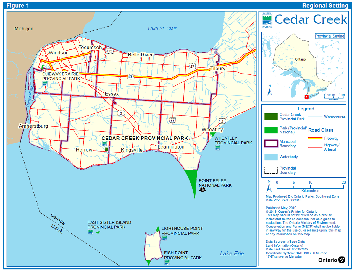
Cedar Creek Provincial Park is a 70 hectare nature reserve class park located in southwestern Ontario within Essex County, approximately 35 kilometres southeast of the City of Windsor (Figure 1: Regional Setting). Cedar Creek Provincial Park protects significant natural heritage features, such as a portion of the Cedar Creek Life Science Area of Natural and Scientific Interest
Cedar Creek Provincial Park is one of several properties protected as part of the Ontario Parks Legacy 2000 partnership between Ontario Parks and the Nature Conservancy of Canada (NCC), and through local community-based efforts. Ontario Parks is responsible for planning, managing and protecting the site as a nature reserve class provincial park under the Provincial Parks and Conservation Reserves Act, 2006 (PPCRA), and in accordance with a long-term lease agreement with NCC endorsed in March 2006.
2.0 Planning context
The PPCRA requires that management direction is approved for each provincial park in Ontario. This management plan fulfils this requirement, and provides long term direction for managing the park, including the purpose and vision, objectives, zoning, policies and implementation priorities. This management plan is written with a 20 year time horizon in mind.
The PPCRA has two principles that guide all aspects of planning and management of Ontario’s system of provincial parks and conservation reserves:
- Maintenance of ecological integrity shall be the first priority and the restoration of ecological integrity shall be considered.
- Opportunities for consultation shall be provided
This management plan has been prepared consistent with all relevant legislation and provincial policies. The implementation of projects in this provincial park will be subject to environmental impact assessment and evaluation processes. This may include further opportunities for consultation, as required.
2.1 Ecological integrity
The PPCRA defines ecological integrity as follows:
Ecological integrity refers to a condition in which biotic and abiotic components of ecosystems and the composition and abundance of native species and biological communities are characteristic of their natural regions and rates of change and ecosystem processes are unimpeded.
Ecological integrity addresses three ecosystem attributes – composition, structure and function. Ecological integrity is based on the idea that the composition and structure of the provincial park should be characteristic for the natural region and that ecosystem functions should proceed normally. In other words, ecosystems have integrity when they have a mixture of native living components (plants, animals and other organisms), non-living components (such as rock, water and soil), and processes (such as reproduction and population growth) and the interactions between these parts are not disturbed (by human activity).
This management plan describes the contribution that Cedar Creek Provincial Park makes to achieve the objectives and principles set out in the PPCRA, and identifies site-specific management policies intended to maintain, or where possible, restore ecological integrity.
3.0 Indigenous communities
The park is located on lands within Treaty 2, 1790 and the traditional territory of the Chippewa and Attawandaron. Additionally, the park falls within the Haudenosaunee traditional territory referred to as The Beaver Hunting Grounds in the 1701 Albany Deed. The closest Haudenosaunee communities to the park are Oneida Nation of the Thames and Six Nations of the Grand River.
Local Indigenous communities include the Caldwell First Nation and Bkejwanong First Nation (Walpole Island). These communities were invited to engage in the park management planning process for Cedar Creek. A summary of Indigenous community involvement can be found in Appendix II: A Summary of Indigenous Community Involvement and Public and Stakeholder Involvement.
4.0 Location and boundary
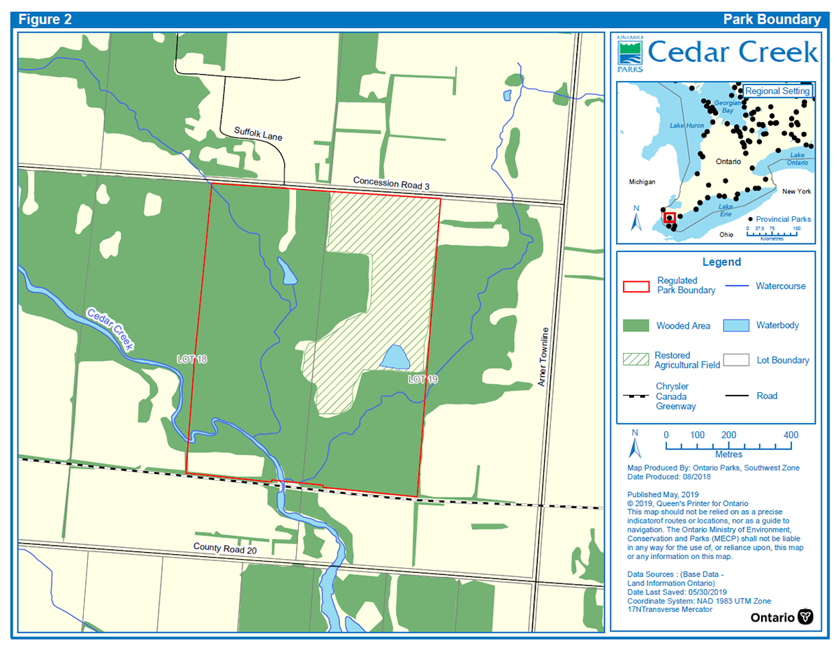
Cedar Creek is located in southern Ontario, approximately 35 kilometres southeast of the City of Windsor, 15 kilometres south of the Town of Essex, and 8 kilometres east of the community of Harrow. The property is bordered by 3rd Concession Road to the north, the Chrysler Canada Greenway (a segment of the Trans Canada Trail formerly utilized as a railway) to the south and private properties to both the east and west (Figure 2: Park Boundary). The boundary of Cedar Creek Provincial Park was established through an amendment to Ontario Regulation 316/07 under the PPCRA in 2014.
This 70 hectare provincial park occurs entirely within Ecodistrict 7E-1
Adjacent land uses consist of agriculture, estate residential, and a recreational trail on conservation lands (Chrysler Canada Greenway/Trans Canada Trail). Parks and other protected areas in the region include Wheatley Provincial Park, Ojibway Prairie Provincial Park, East Sister Island Provincial Park, Point Pelee National Park, Fort Malden National Historic Site, Bois Blanc Island Lighthouse National Historic Site, and a number of conservation areas managed by Essex Region Conservation Authority (ERCA).
5.0 Provincial park classification
Classification organizes Ontario’s provincial parks into broad categories and determines the general policy basis for park management. Each park class has an objective and particular characteristics which contribute to the overall provincial park and conservation reserve system and in turn direct the type and extent of activities that may take place in a particular park.
Cedar Creek Provincial Park is classified as a nature reserve class park. Nature reserve class parks are areas selected to protect representative ecosystems and provincially significant elements of Ontario’s natural heritage, including distinctive natural habitats and landforms, for their intrinsic value, to support scientific research and to maintain biodiversity.
6.0 Purpose and vision statements
6.1 Purpose statement
The purpose of Cedar Creek Provincial Park is:
6.2 Vision statement
The vision for the park is a healthy environment where natural features and native habitat communities persist free of degradation to the greatest extent possible and ecosystem functions continue unimpaired.
7.0 Provincial park objectives
Ontario’s provincial park system has four objectives, as stated in the PPCRA: protection, ecologically sustainable recreation, heritage appreciation, and scientific research.
7.1 Protection
Cedar Creek Provincial Park’s protection objective is to permanently protect a representative sample of Ontario’s provincially significant natural features, while maintaining the park’s natural values and cultural heritage values. Protection will be achieved through appropriate zoning, control of land use and activities, education, and monitoring of ecological impacts. Appropriate mitigation of potential impacts will ensure continued protection of significant features.
7.2 Recreation
The park’s recreation objective is to offer ecologically sustainable, low-impact day-use recreation, such as hiking, to a range of Ontario residents and visitors. Recreation will be encouraged in a manner which fosters appreciation for the natural and cultural heritage values of the park, while ensuring the level of protection granted to nature reserve class parks.
7.3 Heritage appreciation
Cedar Creek’s natural and cultural heritage appreciation objective is to enable exploration and appreciation of the natural and cultural heritage of Cedar Creek in a manner that is not destructive or intrusive to the park’s features and landforms.
7.4 Scientific research
The park’s scientific research objective is to encourage scientific research that enhances knowledge of the park’s ecology, biodiversity and significant natural heritage elements, and contributes to understanding and maintaining landscape-level function.
8.0 Provincial park values
8.1 Earth science values
8.1.1 Bedrock geology
Bedrock is not exposed on site. The bedrock surface lies beneath more than 150 metres of glacial deposits (Morris and Cousineau 1994) and consists of limestone and dolostone of the Detroit River Group (Hewitt 1972).
8.1.2 Surficial geology
Cedar Creek Provincial Park is a complex of relatively flat, upland, well drained forests intersected by steeper slopes that lead down to flat lowland creek valleys carved by Cedar Creek and its tributaries. The flat upland topography consists of till plains overlain with shallow clay deposits, as is characteristic of the Essex clay plain portion of the St. Clair Plains Physiographic Region, in which the park exists (Allen and Oldham 1989). The prevailing soil type is Brookstone clay loam with undifferentiated sand, silt, clay and muck soils occupying creek valleys (Cowell 2006).
The park provides a good representation of the Essex clay plain portion of the St. Clair Clay Plain Physiographic Region. Landforms include the silty clay to discontinuous sand/gravel glaciolacustrine plain (Late Wisconsinan/Early Holocene); two post-glacial lake abandoned beach ridges (Early Holocene); and the alluvial valley and deposits of Cedar Creek (Holocene- Present) (Cowell 2006).
Two abandoned beach ridges in the northeast corner of the park provide representation of early Holocene post-glacial lake action in the Lake Erie basin. As these features are not otherwise represented in parks or reserves on the St. Clair clay plains, they are ranked as regionally significant.
The most striking physical feature of the park is the Cedar Creek valley which bisects the park from north to south. This valley began to form during glacial retreat about 11,500 years ago, when Lake Erie would have been lower than the present lake level by about 30 metres. This low lake level allowed the flowing glacial meltwater to cut through the previously deposited glacial till and glaciolacustrine material resulting in the formation of the creek valley at its lowest elevation. Once the lake level rose, the creek was backed-up resulting in the formation of meanders and floodplains along the valley floor, and subsequently, the deposition of the present alluvial deposits in the valley (Cowell 2006). In addition, two tributaries converge with Cedar Creek proper in the park. One tributary enters the park from the southeast and the other from the northwest, both only travel a short distance to join up with Cedar Creek.
8.2 Life science values
Cedar Creek lies within Ecodistrict 7E-1 and the diverse Carolinian Life Zone
The park contains habitat for numerous species at risk and provincially rare species
The park provides interior woodland and meadow habitat that supports birds and other species during migration as well as species at risk breeding birds, including past breeding occurrences of bald eagle. Eastern mole (special concern species) has been documented in the vicinity of the park.
Cedar Creek Provincial Park protects a portion of Cedar Creek and its associated riparian and floodplain habitats, and the creek contains a warm-water community that provides habitat for fish and mussels, including fish species at risk.
8.3 Cultural heritage values
A Stage 1 archaeological assessment was completed for the park in 2018 (Beaudoin and Gostick 2018). The report concluded there is potential for pre-contact and historic First Nations archaeological resources within the park, based on ancient and contemporary water courses, including Cedar Creek. Before European settlement, it is believed that the area served as hunting grounds for the Indigenous people of the region. No pre- or post-European settlement cultural heritage resources have been identified in the park.
8.4 Outdoor recreational values
The diverse habitats within Cedar Creek present an opportunity for a range of visitors, such as nearby residents, school groups and hikers, to explore outstanding recreational landscapes through low-intensity day-use activities such as hiking.
9.0 Summary of pressures
The park is influenced by various factors such as site history, adjacent land uses, and the health of the Cedar Creek watershed and natural heritage system. Unauthorized trail creation and all-terrain vehicle use in Cedar Creek Provincial Park have resulted in damage to vegetation, sensitive habitats and wetlands, by causing rutting and erosion, and increasing litter and invasive species spread. Alien and invasive species have been identified in the park and threaten the viability of the park’s native species. Effects associated with climate change, such as increased risk and spread of disease in wildlife, and more intense wind and rain events, may negatively impact park values in the future.
10.0 Zoning
Zoning is a tool used to delineate areas within a provincial park that have common management objectives, intentions, values, operations and/or uses. Values and uses in a specific portion of the provincial park with common management needs and intent are typically addressed under one zone through specific policies.
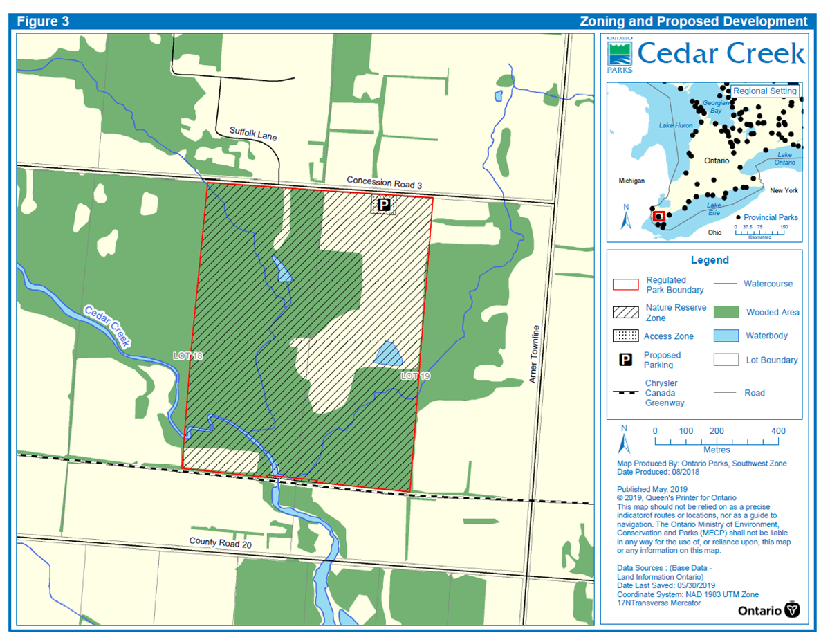
Lands and waters contained within Cedar Creek are zoned in accordance with their natural heritage values along with their sensitivity to development and requirement for protection. The two zoning categories designated for Cedar Creek (access zone and nature reserve zone) are based on the Ontario Provincial Parks: Planning and Management Policies (1992). The access and nature reserve zones differentiate the sensitivity of natural values and the permissible degree of management practices within the park. Zoning for Cedar Creek Provincial Park is described below and shown in Figure 3: Zoning and Proposed Development.
10.1 Access zone
Access zones serve as staging areas, a means of both providing and regulating use and access to other areas of the park. Generally development is limited to roads, management facilities and visitor structures. Provisions may be made for limited orientation, interpretive or educational facilities, though generally more for self-use rather than through structured guided services. Limited facilities for research and park management may also be present.
Zone number and name (size): A1 – Park entrance (approximately 1.0 ha)
Description: Zone A1 will encompass the park entrance in the northeast corner of the park. It will utilize an existing driveway and a portion of the former agricultural field off of 3rd Concession.
Management intent: Zone A1 will provide entrance to the park’s proposed trail system.
10.2 Nature reserve zone
Nature reserve zones protect the provincially significant earth and life science features within a park, and may include a protective buffer area. Development in nature reserve zones is generally restricted to trails, necessary signs, and temporary facilities for research and management.
Zone number and name (size): NR1 – Natural area (approximately 69 ha)
Description: The 69 hectare nature reserve zone protects the provincially significant life science features within the park and includes former agricultural fields that are being restored to more natural conditions.
Management intent: This zone will ensure the protection and continued existence of the significant features and landforms found within the nature reserve area. This zone will provide low-impact ecologically sustainable recreational activities.
11.0 Partnerships
Partnerships will be essential to achieving park objectives. Ontario Parks may explore and pursue opportunities for new or continuing partnerships, involving other agencies and groups, through formal and informal partnership agreements. Partners may represent the local community, local and provincial interests or the private sector. Partners may work with Ontario Parks to assist with implementing the park management plan, per provincial park policies and regulations.
The site of Cedar Creek Provincial Park was acquired through a joint initiative between NCC and Ontario Parks under the Ontario Parks Legacy 2000 partnership. Acquisition funding raised by NCC included a significant contribution from the ERCA. Ontario Parks will continue to engage with the NCC and ERCA as the Cedar Creek Provincial Park Management Plan is implemented.
11.1 Agricultural field restoration
Restoration of the former agricultural field was completed through a partnership with the ERCA. Pit-and-mound techniques and tree planting were used to restore approximately 10 hectares in 2013 and approximately 7 hectares in 2015. The site was planted with a diverse group of native species, appropriate to the soil and moisture regimes and the existing, mature forest community directly adjacent to the agricultural field.
The majority of the remaining unrestored portion of the agricultural field was turned into a 0.8 hectare wetland pond by ERCA in partnership with Ducks Unlimited Canada in 2016. The wetland provides habitat to wetland dependent wildlife including species at risk, and provides a host of other valuable ecological services to the surrounding area.
12.0 Policies
This section provides site specific management policies and any associated actions required to effectively manage this provincial park in accordance with applicable legislation and provincial policies. Section 13 provides a summarized list of priority actions identified for this provincial park.
An adaptive management approach will be applied to resource and other management activities within Cedar Creek. Adaptive management allows for modification of management strategies in response to monitoring and analysing the results of past actions to improve resource stewardship.
All projects undertaken by Ontario Parks, or by partners on its behalf, will comply with all environmental impact assessment and evaluation processes, and other applicable provincial and federal legislation and policies.
12.1 Industrial and commercial activities
The following activities are not permitted in Cedar Creek Provincial Park:
- commercial timber harvesting
- generation of electricity
- aggregate, topsoil and peat extraction
- prospecting, staking mining claims and developing mineral interests
- mining (including but not limited to oil, gas and salt resources)
- commercial bait harvesting
- commercial trapping
12.2 Fisheries
Cedar Creek Provincial Park contains Cedar Creek and two tributaries within Fisheries Management Zone 16
12.3 Wildlife
12.3.1 Wildlife population management
Wildlife (such as white-tailed deer, beaver, turkey, raccoon) may be controlled when essential to human health and safety, the health of the species, or the values for which the park has been established. The reduction of hyper-abundant populations (such as white-tailed deer) may be undertaken. Control methods, including lethal methods, will be undertaken directly by Ontario Parks or through partnerships. Where control is necessary, techniques will be used that avoid or minimize negative effects on other components of the park’s environment.
Native wildlife species may be reintroduced, and existing populations enhanced, if feasible and acceptable, and desirable for perpetuating park values.
12.3.2 Wildlife habitat management
Habitat management will be directed toward promoting healthy and diverse native populations and communities, and may be carried out as funding and/or partnerships are available. Where planting or seeding is necessary, species native to the park will be used, from sources that originate in or near the park wherever possible. Mowing, vegetation thinning and removal, mechanized excavation (such as wetland creation), limited pesticide application, and/or other appropriate techniques may be used to restore and maintain natural values for which the park was established to protect.
Projects to enhance or restore native wildlife habitat and vegetation will be implemented where feasible and appropriate. Restoration projects will aim to maintain or improve habitat quality and connectivity, biodiversity, and ecosystem function.
The restored wetland was constructed to require minimal operational requirements, however occasional monitoring, maintenance and inspection may be required to ensure function is retained.
The remaining foundations of demolished buildings or infrastructure on the property may be retained as potential snake hibernacula (overwintering sites) and thermoregulation features.
12.4 Vegetation
12.4.1 Vegetation management
Native species may be reintroduced, and existing populations enhanced, if feasible and acceptable, and desirable for perpetuating park values. Vegetation may also be replenished where necessary to control erosion or rehabilitate disturbed areas expected to sustain high recreational use (for example, adjacent to trails). Maintaining vegetation in support of authorized recreational or heritage appreciation opportunities is permitted (such as trail maintenance).
12.4.2 Agricultural practices
A portion of Cedar Creek Provincial Park was farmed before it was acquired to become a provincial park. Active farming has been phased out and the former agricultural field has been naturalized. Agricultural use of the park will not be permitted.
12.4.3 Hazard tree trimming and removal
Except where there is threat to public safety, park values or operations, dead trees and tree limbs will be left standing to serve as habitat for resident cavity nesting birds and mammals including species at risk known to occur in the area such as bats and red-headed woodpeckers. Dead tree falls and tip-ups will also be left in place to serve as sites for mosses and fungi, germination areas for tree species requiring rotting wood as a rooting medium, and moist shelters for small mammals, reptiles, amphibians and a variety of invertebrates.
Where feasible, trees will be trimmed or topped to leave snag habitat, and trimming/removal will follow appropriate management practices (such as best management practices for hazard tree removal, timing windows to protect breeding birds and bats or minimize invasive species spread). This may not be possible in the event of large-scale trimming or removal (for example, as a result of plantation thinning, or invasive forest pests or other infestation).
12.4.4 Vegetative insect and disease control
The occurrence of insects and diseases native to the forest region in which the park is situated is recognized as an integral component of the ecology of the park. Native insect infestations and diseases will be allowed to progress naturally. If such outbreaks threaten values for which the park was established to protect, they may be controlled where feasible, and may include the use of biological controls.
12.5 Forest fire management
Fire management within Cedar Creek will focus on protecting public health and safety, and preventing personal injury, property value loss and social disruption.
12.5.1 Prescribed burning
Prescribed burning is the deliberate, planned and knowledgeable application of fire by authorized personnel to a specific land area to accomplish predetermined objectives. To achieve park management objectives and maintain and restore ecological integrity, prescribed burning may be considered where feasible. Plans for any prescribed burning will be developed in accordance with Ministry of Northern Development, Mines, Natural Resources and Forestry (NDMNRF) policy in cooperation with NDMNRF fire management staff and/or the municipal fire department.
Cedar Creek Provincial Park would benefit from prescribed burns as disturbance events would improve and maintain prairie or meadow habitat used by birds, snakes and pollinators such as bumblebees and monarch butterflies, for critical life processes. Disturbance is needed to manage succession and maintain habitat for some rare and at-risk species in the park, especially plants that rely on these habitats. Prescribed burning may be used to enhance meadow or prairie communities within areas that are succeeding to shrub thicket communities, especially where rare plant species have been previously observed. It may also be used to enhance communities within the restored agricultural field.
12.6 Rare and at-risk species
The park will be managed to protect and recover rare and at-risk species and habitats as feasible. Species at risk will be protected consistent with the Endangered Species Act, 2007 and associated regulations, policies, and guidance. Species recovery actions may be implemented in accordance with relevant government response statements and Ontario Parks’ policies.
Ontario Parks may conduct protective and restorative management projects for species at risk, rare species and their habitats, such as installation of habitat structures or features, augmentation or reintroduction of species, and maintaining various habitat types to support species that use those habitats.
12.7 Alien and invasive species
Alien species are plants, animals, fungi and micro-organisms that have been unintentionally or deliberately introduced by human activity into areas beyond their normal range. Alien species will not be deliberately introduced into the park unless in accordance with provincial and federal legislation and guidance, and Ontario Parks policy.
Invasive species are alien species whose introduction or spread threatens the environment, the economy and/or society, including human health. Invasive species are known to occur in the park (for example, garlic mustard, periwinkle, European common reed) along roads, trails, and watercourses. Establishment and spread have occurred due to site history (agricultural and residential use), recreational use, unauthorized access, and adjacent land use. Where invasive species threaten natural and cultural values or human health, a control program may be initiated if feasible and practical.
Insects and diseases not native to the park’s forest region may be controlled where feasible. When control is undertaken, it will be directed as narrowly as possible to the specific insect or disease, so as to have minimal effects on the balance of the park's environment.
12.8 Cultural heritage
Cultural heritage values will be protected, maintained, used and disposed of in accordance with existing applicable legislation and policies. If cultural heritage values are discovered in the park, Ontario Parks will follow requirements outlined in relevant cultural heritage policy. Additional technical cultural heritage studies will be conducted as necessary, to build upon previous studies related to the park’s cultural heritage values.
12.9 Land
12.9.1 Park additions
In principle, Ontario Parks supports the acquisition of land to enhance protection or park management. Adjacent lands with similar values would be of highest priority. If lands are offered for sale or donation, staff will evaluate how they contribute to park objectives. Suitable properties would only be acquired from willing sellers or donors, and only if there is available funding.
12.9.2 Private land disposition
Disposition of land for private use is not permitted.
12.10 Research, inventory and monitoring
Research provides a better understanding of park environments, and contributes to appropriate management practices and actions.
Research projects undertaken by external parties require authorization issued under the PPCRA, consistent with relevant policies. Research must meet all requirements under applicable provincial and federal legislation, and may require additional permits or approval (for example, authorizations under the Fish and Wildlife Conservation Act, 1997 or Endangered Species Act, 2007). Proposed research will be reviewed by Ontario Parks to ensure adequate consideration of potential impacts on park resources, features, staff and visitors.
Monitoring in Cedar Creek Provincial Park may occur (such as through site visits and aerial and/or ground level photographs) to help identify the early presence of disease or invasive plant, animal and insect species; impacts of climate change; and other threats to the park’s ecological integrity.
Ontario Parks will encourage efforts by naturalist groups and other partners to document the park’s diversity and abundance. Quantitative and qualitative life science inventories will be completed as necessary, and existing inventories, such as ecological land classification
Ontario Parks may consider allowing temporary facilities in support of approved research and monitoring activities. Sites altered by research activities must be rehabilitated as closely to their previous condition as possible, except where the specific intent of the research activities is disturbance for the purpose of ecological enhancement or restoration.
Priorities for research, inventory, and monitoring, may include, but are not limited to:
- ecology and biology of natural heritage features, including species at risk populations and habitats, vegetation communities, biodiversity, and ecological functions and processes
- cultural heritage and history
- populations of invasive species and forest pests, disease, and their prevention and control
- recreation, including trends, benefits, effects, and ecological sustainability
- effectiveness of management actions, including reduction of pressures
- climate change
12.11 Recreation
Where compatible with park values, low-intensity day-use recreational activities, such as hiking, will be permitted on designated trails. There will be no winter trail maintenance. Camping, the operation of off-road and all-terrain vehicles, snowmobiling, biking, sport hunting and horseback riding are not permitted in Cedar Creek Provincial Park.
Any recreational use or activity which negatively impacts natural values may be confined or discontinued.
12.12 Infrastructure management and development
Areas proposed for development will require prior assessment for cultural heritage resources and natural values to ensure these values are identified and protected at the site. All projects will be carried out in accordance with approved site and development plans that meet development standards for provincial parks. The location, design and materials of all facilities will, as much as possible, reflect the natural character of the park and minimize light pollution. Durable, low maintenance and energy efficient designs and materials will be used whenever possible.
Development may include signs, fencing and gates, as required to prevent unauthorized access, rutting from motorized travel, creation of unauthorized trails, destruction of vegetation and damage to sensitive habitats.
There is a water well and an abandoned oil and gas well in the park. The water well, located just north of the foundation of a demolished house, will be sealed in accordance with current standards. The oil and gas well was sealed in the early 1920s to standards of the time. Should the abandoned oil and gas well pose a threat to human health and safety or park values, it will be plugged in accordance with current standards.
12.12.1 Access
Public access to Cedar Creek will be provided in the northeast corner of the park using an existing laneway off of Concession Road 3 (A1; Figure 3). A park sign, gate and small parking lot will be developed. A vault toilet and storage shed may be developed, if required.
12.12.2 Trails
There are currently no formally designated trails in Cedar Creek Provincial Park. A hiking trail will be developed and may use portions of existing unauthorized trails. Other unauthorized trails will be closed and rehabilitated. Trails may be realigned or re-routed to minimize impacts to sensitive species or features.
12.12.3 Interpretative facilities
Self-guided interpretive panels may be installed at key locations along the trail to highlight unique or significant park features or educate visitors to promote protection of park values. Services for visitors will be oriented towards self-guided use. Interpretive facilities will be modest.
12.13 Operations
Ontario Parks maintains park operations plans to provide park staff with the necessary direction to manage each park on a day-to-day basis. Park operations plans include such topics as budget, staffing, maintenance schedules, enforcement, and emergency services. Policies governing operations for Cedar Creek will be incorporated into the park operations plan for Wheatley Provincial Park. Operations will be consistent with Ontario Parks Operating Standards (2018) and will be reviewed annually and updated as required. The park will receive no winter maintenance.
Ontario Parks’ staff may use or authorize any vehicle to the extent necessary for emergency actions, efficient park operations, and management activities in the park. Where possible, park operations will avoid or minimize negative environmental impacts. Other public agencies may use any vehicle for emergency operations within the park, subject to approval from the park superintendent.
13.0 Implementation priorities
The following table summarizes and prioritizes the actions identified in the policies section above. Implementation of actions is subject to:
- applicable legislation and provincial policy
- environmental impact assessment requirements
- the availability of financial and human resources
| Action identified in management plan | Comments |
|---|---|
Short term |
|
| Closure of unauthorized trails | Unauthorized trails will be closed and rehabilitated as identified in Section 12.12.2. |
| Install signage, boundary fencing and gates | Install fencing around the perimeter of the park, clearly identify park boundary and access point, and install signs and gates as required, as identified in Section 12.12. |
Medium term |
|
| Develop hiking trail | A trail will be developed to encourage nature appreciation and recreation, in accordance with Section 12.12.2. |
| Seal water well | The water well located within the park will be sealed in accordance with current standards, as identified in Section 12.12. |
Long term |
|
| Install interpretative panels | Interpretive panels may be installed along the trail, as identified in Section 12.12.3. |
| Develop a parking lot | A small parking lot will be developed in the former agricultural field on the existing laneway as identified in Section 12.12.1. |
| Construction of a storage building and/or vault toilet | If required, maintenance and visitor facilities such as a small storage building and/or vault toilet may be constructed at the park entrance in Zone A1, in accordance with Section 12.12.1. |
14.0 Examination and adjustment
This management plan will be examined in accordance with the provisions of the PPCRA to determine whether it is still relevant, effective and current or if adjustments are needed. In circumstances where the plan is not providing sufficient direction, or to address specific issues or pressures, it can be examined prior to the next scheduled examination.
15.0 References
Allen, G.M. and M.J. Oldham. 1989. A Life Science Inventory and Evaluation of Cedar Creek, Essex County, Ontario: An Area of Natural and Scientific Interest (ANSI). Chatham District, Southwestern Region, Ontario Ministry of Natural Resources.
Allen, G. M. and M. J. Oldham. 1990. Cedar Creek Area of Natural and Scientific Interest – A Life Science Inventory. Chatham District, Southwestern Region, Ontario Ministry of Natural Resources.
Beaudoin, M. and K. Gostick. 2018. Stage 1 Archaeological Assessment Cedar Creek Provincial Park, Parts of Lots 18 and 19, Concession 2. Geographic Township of Colchester, Town of Essex, Essex County, Ontario, Timmins Martelle Heritage Consultant Ltd. for the Ministry of Natural Resources and Forestry.
Chapman, L.J. and D.F. Putnam. 1984. The Physiography of Southern Ontario. Third Edition, Ontario Geological Survey, Special Volume 2, Toronto.
Cowell, D.W. 2006. Earth Science Inventory Checklist for Cedar Creek Recommended Provincial Park (Nature Reserve Class). Ontario Ministry of Natural Resources.
Endangered Species Act, 2007, S.O. 2007, c. 6
Fish and Wildlife Conservation Act, 1997, S.O. 1997, c. 41
Hewitt, D.F. 1972. Paleozoic Geology of Southern Ontario. Ontario Division of Mines, Geological Report 105: 18p + Map 2254 (scale 1:1,013,760).
Klinkenberg, R. 1982. Cedar Creek Life Science Inventory Check-sheet. Ontario Ministry of Natural Resources, Division of Parks, Park Planning Branch, Toronto.
Klinkenberg, R. 1984. Life Science Areas of Natural and Scientific Interest in Site District 7-1. A Review and Assessment of Significant Natural Areas in Site District 7-1. Ontario Ministry of Natural Resources, Parks and Recreational Areas Section, Southwestern Region, London.
Morris, T.F. and G.R. Cousineau. 1994. Bedrock Topography, Essex County Area (East Half), Southern Ontario. Ontario Geological Survey, Preliminary Map P3256, scale 1:50,000.
Ojibway Nature Centre. 2004. 2004 Cedar Creek Christmas Bird Count. Windsor Parks and Recreation. Available at: http://www.ojibway.ca/cedar04.htm
Oldham, M. J. 1983. Environmentally Significant Areas of the Essex Region. Essex Region Conservation Authority, Essex, Ontario.
Ontario Ministry of Natural Resources. 1992. Ontario Provincial Parks: Planning and Management Policies, 1992 Update.
Ontario Ministry of Natural Resources and Forestry. 2014. Ontario’s Protected Areas Planning Manual: 2014 Edition. Peterborough. Queen’s Printer for Ontario. 33 pp.
Ontario Ministry of Natural Resources and Forestry. 2018. Ontario Parks Operating Standards.
Ontario Ministry of Natural Resources and Forestry. 2019. Species at Risk in Ontario. Available at: https://www.ontario.ca/environment-and-energy/species-risk-ontario-list
Ontario Ministry of Tourism and Culture. 2010. Standards and Guidelines for Conservation of Provincial Heritage Properties. Available at: http://www.mtc.gov.on.ca/en/publications/Standards_Conservation.pdf
Provincial Parks and Conservation Reserves Act, 2006, S.O. 2006, c. 12
Appendix I: Provincial park maps
Appendix II: Summary of Indigenous community involvement and public and stakeholder involvement
Public involvement is a very important part of the park management planning process. The three phases of the management planning process are:
- Phase 1 - Terms of reference and background information
- Phase 2 - Preliminary park management plan
- Phase 3 - Release of approved park management plan
Phase 1 – Invitation to participate; terms of reference and background information
The invitation to participate and to review the approved terms of reference and background information included Indigenous community, stakeholder and public involvement opportunities. In advance of the formal public consultation process, the terms of reference and background information were distributed to adjacent landowners, key stakeholders, local Indigenous communities, Bkejwanong First Nation (Walpole Island) and Caldwell First Nation in early 2004, and a public open house was held on October 15, 2004.
The formal consultation process began on November 21, 2006 and included:
- local newspaper advertisements
- direct mailing of notices to local Indigenous communities and known stakeholders
- an Environment Registry proposal notice (posted for 52 days)
- notice distribution to park, zone and district offices
Ontario Parks received five responses generally supportive of the proposal or wanting more information.
Additional correspondence was subsequently sent to the Chiefs of the Bkejwanong First Nation (Walpole Island) and Caldwell First Nation to provide an update on the status of the planning process and to reiterate that Ontario Parks was interested in speaking directly with their communities about this planning project.
Ontario Parks staff met with representatives of Bkejwanong First Nation (Walpole Island) on May 21, 2009 to discuss the planning, long term management and the proposed boundary of Cedar Creek. At their request, all public comments received during the park management planning process were provided for their review.
A land use amendment was coordinated with the park management planning process, commencing after phase 1. The amendment addressed the establishment of Cedar Creek as a recommended provincial park (nature reserve class). A policy proposal notice for the minor land use amendment was posted to the Environmental Registry and Regulatory Registry on August 31, 2012. In addition, a notice was distributed to local Indigenous communities, municipal government, local residents, stakeholders and other interested parties. Comments on the proposal were accepted until November 19, 2012.
Ontario Parks received six responses generally supportive of the proposal. The proposal to regulate Cedar Creek as a new provincial park was evaluated as a Category B project under A Class EA-PPCR. The consultation requirements for the land use amendment and the Class EA were completed concurrently, and the consultation periods for the Category B project and the Environmental Registry/Regulatory Registry were aligned.
Phase 2 – Preliminary park management plan
The preliminary management plan was posted for public review from February 18, 2020 to April 3, 2020. The policy proposal notice was posted on the Environmental Registry, registry number 019-0061. Approximately 300 letters were mailed and emailed to the management planning contact list, containing an opportunity to review and comment notice. Newspaper ads were placed in the Windsor Star, Essex Free Press, Harrow News, Kingsville Reporter and Windsor Le Rempart (French). Bkejwanong First Nation (Walpole Island) and Caldwell First Nation were also contacted and invited to review and comment on the preliminary management plan.
Seventeen responses were received through a combination of emails, Environmental Registry comments, and a phone call. Comments came from residents, park users, Ducks Unlimited Canada, the Nature Conservancy of Canada, and the Ministry of Heritage, Sport, Tourism and Culture Industries. All comments received were considered in the preparation of the approved management plan. Comments received were generally positive and support the proposed management policies. Some comments suggested expansion or clarification of some proposed management policies.
Comments received identified the following topics:
- recreational uses
- invasive species
- habitat restoration and management
- cultural heritage research
- unauthorized access and use
- visitor infrastructure
Comments received suggested a trail connection from the park’s trail to the popular Greenway Trail, which runs along the southern boundary of the park. Ontario Parks explored this option and decided to not propose such a connection as the Greenway Trail allows horseback riding, mountain biking and experiences high rates of unauthorized uses (such as off-road vehicle use). Horseback riding, mountain biking and motorized trail uses are prohibited in nature reserve class parks; connecting the park’s trail to the Greenway Trail is likely to result in unauthorized uses in the park and damage to the park’s natural and cultural heritage values.
All comments received were considered in the preparation of the approved management plan.
In summary, the changes made between the preliminary document and the final park management plan include the following:
- updated information about species present in the park
- clarified summary of pressures
- added policy on the management of the restored wetland
- updated wildlife habitat management direction
- updated policy on vegetation and tree management
- updated prescribed burning direction
- added consideration surrounding cultural heritage technical studies
- added research priorities
- updated status of abandoned oil and gas well that was sealed in the 1920s
- clarified trails policy and changed the development of a new trail to a medium-term priority
- administrative updates
Phase 3 – Release of approved park management plan
The Cedar Creek Provincial Park Management Plan was approved on October 19, 2021.
A policy decision notice was posted on the Environmental Registry and approximately 300 letters were sent to Indigenous communities, stakeholders and the public to notify of the release of the approved management plan.
Footnotes
- footnote[i] Back to paragraph Areas of Natural and Scientific Interest (ANSIs) are areas of land and water containing natural landscapes or features that have been identified as having life science or earth science values related to protection, scientific study or education.
- footnote[ii] Back to paragraph Species at Risk are plants or animals listed on the Species at Risk in Ontario list under Ontario’s Endangered Species Act, 2007. Species are classified as endangered, threatened, special concern or extirpated based on the various habitat and population indicators.
- footnote[iii] Back to paragraph In Ontario, the Ministry of Northern Development, Mines, Natural Resources and Forestry delineates natural regions to enable landscape planning and monitoring. Ontario is divided into 71 Ecodistricts (formerly known as ecological site districts) based on landforms and biological productivity.
- footnote[iv] Back to paragraph A zone representing the extreme southwest region of Ontario where the eastern deciduous forest of North America has its most northern limits.
- footnote[v] Back to paragraph Rare species are listed by NatureServe or the Natural Heritage Information Centre with global rankings of G1, G2 or G3, national raking of N1, N2 or N3, or provincial ranking of S1, S2 or S3. Conservation status ranks estimate a species’ risk of going extinct or being extirpated. They can also rank a plant community’s risk of elimination.
- footnote[vi] Back to paragraph As part of NDMNRF’s Ecological Framework for Fisheries Management, Fisheries Management Zones (FMZs) are the main spatial unit for planning and managing fisheries in Ontario. The FMZ approach to fisheries management planning does not preclude applying different management approaches in protected areas in order to achieve fisheries and aquatic ecosystem objectives for the planning area and to meet the objectives of the PPCRA.
- footnote[vii] Back to paragraph Ecological land classification (ELC) is used to describe various systems to indicate natural regions based on ecological factors. Ecological units are distinguished from one another on the basis of bedrock, climate (temperature, precipitation), physiography (soils, slope, aspect) and corresponding vegetation.