Chutes Provincial Park Management Plan
This document provides direction on the management of Chutes Provincial Park.
Approval statement
We are pleased to approve this management plan for Chutes Provincial Park. It establishes policy for the future ma nagement, development, and use of Chutes Provincial Park. It provides an understanding of the present situation of the Park, why changes are necessary and the specific changes that will be made to the park over the next 20 years.
Chutes Provincial Park will be upgraded through the implementation of the policies herein to meet the recreation and tourism needs of the Massey area and the travelling public on Highway 17. Located in the scenic Aux Saubles River valley, it will continue to provide a high quality and convenient area for recreation and tourist vacation needs.
M.A. Klugman
Regional Director
Northeastern Region
Ontario Ministry of Natural Resources
Norm R. Richards
Director
Parks & Recreational Areas
Ontario Ministry of Natural Resources
1. Introduction
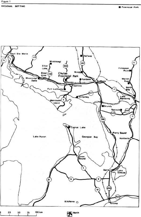
Chutes Provincial Park is situated 1 kilometre north of Highway 17 on Highway 553, adjacent to the Town of Massey (Figure 1). The Park is 448 kilometres northwest of Toronto, 93 kilometres west of Sudbury, and 217 kilometres east of Sault Ste. Marie. The park was first opened in 1963 and was formally established by Ontario Regulation 165/70, Schedule 78, in 1970. It is 108 hectares in size consisting of wetlands, rock lands, floodplains, and terraces. Forest cover varies depending on soil and moisture conditions. The campground area is mainly reforested with red pine and jackpine. The day use area is mainly poplar. On the east side of the river, a mixture of poplar, maple, spruce, and white pine are found.
Located in the scenic Aux Saubles River valley, it is an excellent area for camping, picnicking, swimming, and hiking. The park has 134 campsites; 56 have electrical hookups. The park also offers a sand beach, a day use area, 2 kilometres of hiking trails, and a playground area. Crosscountry skiing is popular during the winter season.
The park serves as a stopover point for Highway 17 travelers. Visitor’s length of stay is increasing, especially among senior citizens. The day use are a and beach are used heavily by the people of Massey and area.
Figure 1: Regional Setting Map
2. Classification
Chutes Provincial Park is a recreation class park. The following goal and objectives of Chutes Provincial Park were derived from the Ontario Provincial Parks Policy approved by Cabinet in 1978.
will support a wide variety of day use and car camping recreation opportunities for large numbers of people in attractive surroundings.
Ontario Ministry of Natural Resources, 1978.
3. Goal
To provide visitors with a variety of traditional day use and car camping recreation opportunities that complement the natural landscape setting of Chutes Provincial Park.
4. Objectives
The following objectives of the provincial park system can be achieved in this park: protection, recreation, heritage appreciation, and tourism.
4.1 Protection
To maintain and manage the environment of the park to protect its scenic and recreational values.
Ontario Ministry of Natural Resources, 1978.
The natural and scenic character of the Aux Saubles River will be protected. Developments will be kept to a minimum in the valley.
4.2 Recreation
To provide high intensity outdoor recreation opportunities.
Ontario Ministry of Natural Resources, 1978.
The park will provide an annual supply of 39,655 campsite nights and 10,506 day use opportunities.
4.3 Heritage appreciation
To provide opportunities for exploration and appreciation of the natural and cultural heritage of Ontario.
Ontario Ministry of Natural Resources, 1978.
Chutes’scenic and cultural setting will be interpreted to present stories about the historic logging activity of the area and the forested Aux Saubles River valley. The park will use various methods, including publications like the provincial park leaflet and area brochures, self-guided trails, and outdoor displays to provide visitors with opportunities to understand the special character of this area.
4.4 Tourism
To provide Ontario’s residents and out-of-province visitors with opportunities to discover and experience the distinctive regions of the Province.
Ontario Ministry of Natural Resources, 1978.
The park’s natural and cultural history will be enhanced through visitor services and promoted in ways that appeal to residents and out-of-province visitors who visit the park and surrounding area.
The park offers a natural setting where highway travelers and area residents can get away from development. Tourism services adjacent to and within day use distance of the park, which complement Chutes’ services, will be identified in the park marketing plan. In this way, mutually beneficial promotion programs can be developed between park and other tourism interests (e.g. Town of Massey, Massey and Area Museum, Tourist Association).
5. Boundary
The park encompasses a small area (108 hectares) centered on a 3 kilometre section of the Aux Saubles River (Figure 2). It is bounded by roads on the east and west and by the Canadian Pacific Railway to the south. The north boundary includes part of an island. Some 5 hectares on the island are privately owned. Proposed trail development may determine that the island has potential to provide river crossing sites. Should the private land portion of the island meet park requirements, the Ontario Ministry of Natural Resources may indicate an interest in purchasing it, should it become available and funds permitting.
6. Zoning
Two types of zones will guide resource management and development of the park: a development zone and a natural environmental zone (Figure 2).
6.1 Development Zone (20 ha)
Most of the land on the west side of the Aux Saubles River has been developed and is designated as a development zone. Space for a wide range of day use and camping activities is available in this area.
The campground will be maintained to supply 134 campsites. Day use parking, trails, a viewing platform overlooking the Chutes, and a beach along the Aux Saubles River will be provided. A park operating plan will guide the overall maintenance of facilities. Site plans will be prepared for improvements to existing facilities and prior to the development of new services.
As well as the recreational facilities, a bedding area could be provided here to supply planting stock for park needs.
Figure 2: Zoning Map
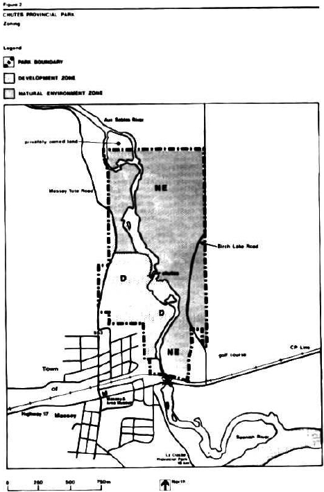
6.2 Natural Environment Zone (88 ha)
A large segment of the park will be included in the natural environment zone. Management will focus on permitting natural ecological processes to continue. Self-guided interpretive trails, lookouts, and ancillary facilities will be developed in this zone to provide day use services for park visitors. The necessary sanitation facilities will be determined with site planning assessments for the trail system.
Motorized recreational vehicles, with the exception of maintenance equipment, will not be permitted in the Natural Environment Zone.
7. Resource management
This section addresses park policies for: vegetation, fisheries, wild life, lands and waters, arid landform management.
7.1 Vegetation
A vegetation management plan will be prepared for the development zone of the park. Diversity of native plant species and a variety of age compositions will be encouraged through ongoing rehabilitation measures. Aesthetics and campsite buffering will be maintained.
Native plant species will be used where possible for landscaping purposes.
Forest insects and disease will be controlled if the park’s recreational and aesthetic values are threatened. The Ontario Ministry of Natural Resources guidelines will apply. Where sprays are used, biological agents will be recommended.
A small bedding area for planting stock of up to 300 trees of native species will be maintained within the development zone north of the campgrounds.
All fires will be suppressed. An agreement for fire fighting will coordinate the efforts of the Town of Massey, the Townships of Spanish River, and the Ontario Ministry of Natural Resources.
7.2 Fisheries
Productive fish habitats occur throughout the Aux Saubles River. Introduction of salmon into the Great Lakes System resulted in the spread of these fish into rivers like the Aux Saubles. This has created viewing and fishing opportunities.
Viewing and fishing will be enhanced through the expansion of the day use trail system. This added attraction could increase use of the park during the autumn and spring.
Some fish stocking occurs each year with the release of rainbow trout into the Aux Saubles River within the park.
Bait fishing will not be allowed within the park.
7.3 Wildlife
A variety of wild life is seen in the park area.
Hunting and commercial trapping will not be allowed in the park.
Animal populations may be controlled when essential to protect human health and safety, and the park environment or the health of the species outside the park (i.e. overpopulation and epidemics). Where control is desirable, techniques will be used that have a minimal effect on other components of the park environment. Nuisance animal control will only be directed at the culprit animal. Live trapping or drug injection will be the normal control measures used to relocate problem animals away from the park. In situations where these measures are not feasible, problem animals will be destroyed. Any hunting or trapping required to control nuis ance animals will be carried out under the strict supervision of, or directly by, the Ontario Ministry of Natural Resources.
7.4 Lands and waters
An easement agreement exists between the Ontario Ministry of Natural Resources and the Town of Massey for a water intake line through the park. This agreement consists of a 4.7 metre wide easement, location CL #1744.
Any upgrading or expansion of this utility line outside the parameters of the existing easement will require prior approval of the Ontario Ministry of Natural Resources.
Also located within the park is a Federal water flow check station for the southern section of the Aux Saubles River and an Ontario Ministry of Natural Resources radio tower located in the east half of the northeast quarter of Section 25, Salter Township. Authorizations for these structures exist through informal agreements.
No new utility lines, rights-of-way, or hydroelectric works will be developed except for those required to service the park.
7.5 Landform management
Shoreline erosion along the Aux Saubles River is a natural process. Costly engineering means of stabilizing this erosion will not be undertaken. Erosional effects within the development zone will be minimized. Vegetation and landform management and the careful location of facilities through site planning will use a combination of techniques to stabilize slopes:
- recontouring erosion-prone areas where feasible;
- establishing plant species along the shore will minimize the scarred appearance of slopes;
- site planning set backs for all facilities and trails from the valley bluffs; and,
- controlling pedestrian circula tion on the valley slopes by strategically locating shore bluff stairs to harden the areas where people walk.
8. Visitor services
Chutes Provincial Park is used as a stopover by people travelling Highway 17 en route to other destinations. Features in the park along the Aux Saubles River valley are representative of a small river drainage basin on the Canadian Shield, and can be used to depict some of the areas’ natural and cultural history. Visitors’ appreciation of this setting will be enhanced through self-use information and interpretation facilities and services as described below.
8.1 Information
Information concerning park re sources, management, facilities, programs, area services, and nearby points of interest will be available in the gatehouse and park office. A bulletin board at the comfort station will contain information on the park and area.
The existing brochure, Highlights of Chutes Provincial Park and the Massey Area , will continue to be used.
8.2 Interpretation
Interpretive services provide the opportunity to create a greater understanding of the natural, cultural, and recreational values of the park and surrounding area.
Park themes will include:
- logging and river driving in the Aux Saubles valley; and,
- natural history of this small drainage basin.
A 2.5 kilometre loop trail system will be developed including additional lookouts and related facilities at scenic points in the park.
The viewing platform overlooking the Chutes will be maintained with outdoor interpretive information.
Park interpretive facilities will be designed through site planning to provide high quality services for self- use by visitors. Some programs will be offered by guest speakers and park staff.
8.3 Marketing
The Chutes Provincial Park Marketing Plan (1980) will be updated to reflect a broader service for visitors to promote park and area attractions:
- Park Services;
- services in the Town of Massey (e.g. groceries, auto/trailer services, golfing, restaurants, Massey Fair);
- Massey Tote Road recreation uses (e.g. wildlife viewing, sport fishing, boating, and canoeing on area lakes);
- shoulder season uses given the potential for sport fishing and salmon viewing outside or in the park; and,
- LaCloche Provincial Park - when facilities are developed.
In this way, park visitors will be informed about provincial park and regional tourist attractions, programs, and services.
9. Development
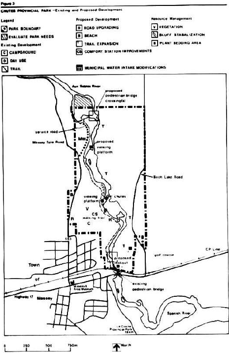
Development will proceed in accordance with Figure 3 and the following guidelines.
Park facilities will complement other services in the area. Site planning will be necessary prior to the development of new services or to upgrade existing facilities. These projects will be phased in according to the Plan’s Implementation and Review section. The Environmental Assessment Act and other relevant legislation will be adhered to.
All facilities in the park will be maintained to provincial park standards and according to approved procedures. The park operating strategy will be updated as required to reflect current park operations.
Figure 3: Existing and proposed developments
9.1 Park roads
There are two potential areas of congestion in the existing road system; the entrance and the hill to the day use area. Congestion in these sections of the park roads can affect the safe circulation of traffic and visitors’ ease of movement within the park. Site planning will evaluate the existing layout of these sections of road and determine appropriate measures, when required, to upgrade alignments, drainage, or surfacing to provide safe circulation of traffic. Hard surfacing of all park roads is recommended.
9.2 Beach and day use areas
The day use beach is artificially maintained to provide a small sandy backshore sunbathing area. Crowding occurs here during peak use. Site planning will identify the potential to expand the existing beach upstream to the Chutes. Elaborate engineering works will not be undertaken.
Site planning evaluations of the campground, areas C and D, and the grounds adjacent to the comfort station will identify the type and scale of children’s play equipment that is necessary for visitor’s use.
9.3 Town water supply
The Town of Massey obtains their domestic water from the Aux Saubles River within the park (Location Cl#1744). The Town would like to upgrade their intake to provide more water during low summer flow periods. The Ministry of Natural Resources concurs that the Town obtain an engineering survey to evaluate the feasibility of upgrading their water intake.
The Ontario Ministry of Natural Resources will be involved in any such study to identify park values and concerns: aesthetics, water quality, fisheries habitat, and potential uses associated with such a structure.
9.4 Trail system
There is a path along the west side of the river valley within the park. As well, a spur of this path takes visitors to the east side of the river and a lookout over the town of the radio tower site.
Site planning will determine the best alignment for a new 2.5 kilometre trail to provide day use services within the Aux Saubles River valley. A pedestrian bridge is required at the northern limits of the trail to maximize trail length by providing access to the east side of the river. Other improvements including a viewing platform, vault privies, and shelters for day use will be developed (Figure 3).
In the short term, for the southern portion of this trail, the old Highway Bridge, south of the park boundary will continue to be used as a crossing for park visitors. The agreement with the Ontario Ministry of Transportation and Communications will be retained to authorize this use. A new pedestrian bridge location will be selected and a suitable bridge constructed to provide an alternate crossing in the park.
In the future, consideration will be given to develop alternate day use access from Birch Lake Road to the park trail system.
No motorized recreational vehicles with the exception of maintenance vehicles will be permitted on park trails.
9.5 Comfort station
The existing comfort station’s showers and washroom services are well used. A solar assisted water heating system supplements the production of hot water for the building. The solar heating system, which was added to the building in 1979, will be reconditioned to increase solar heating capability.
Architectural redesign of the comfort station is required before this facility is renovated.
10. Public consultation
This Park Management Plan is the result of a continuing consultation process that has considered the needs, desires, and opinions of a variety of interests.
Public involvement in the management plan first began during the spring of 1986 with news releases requesting public participation in reviewing a preliminary plan in the summer. This review continued from July to early September at the Park and the Espanola District Office. Copies of the preliminary management plan were mailed directly to interest groups, local municipalities, other government ministries, and adjacent property owners.
The public was requested to submit, within 30 days, any comments regarding the preliminary management plan to the District Manager at Espanola. No outstanding issues were identified in the public review. Copies of all comments which were received are available for viewing at the Espanola District Office.
In approving this Park Management Plan, our Ministry is committed to continuing this consultation with government agencies, other minis tries, and the public. It is important that the channels of communication that have been created by this consultation process be kept open.
11. Plan implementation
Implementation of the approved management plan is summarized in this section.
A park operating strategy will be updated annually.
Work program planning and funding proposals will be based on the implementation of these aspects of the plan according to the following phases:
Phase 1: Short term work program planning
Resource management
- develop and implement a vegetation management plan for the development zone (including plant bedding needs);
- establish a fire fighting agreement between the Town of Massey, the Town of Spanish River and the Ontario Ministry of Natural Resources.
Visitor services
- prepare a visitor services plan implementing communication and interpretation efforts to encourage day use and overnight stay in the park and area.
- update the park marketing plan to provide direction for joint marketing of park and area attractions through complementary tourism efforts (e.g. Town of Massey promotions, area tourism initiatives).
Development
- site planning evaluation of park road upgrading needs;
- site planning evaluation of day use parking needs at the Chutes viewing platform;
- site planning evaluation for potential expansion of the day use area;
- site planning assessment of day use play areas in campground sections C and D and at the comfort station;
- coordination with Massey’s engineering evaluation of instream improvements to town water in take to ensure future compatibility of this facility with park trail needs (e.g. pedestrian bridge);
- site planning of the proposed trail system including facilities that could complement park use; and,
- architectural redesign of the comfort station’s solar water heating facility.
Phase 2: Long term additional funding requirements
- road work as required as per approved site plans for:
- entrance,
- day use area,
- hard surfacing of all roads;
- beach expansion as per approved site plans;
- playground/fitness exercise stations at campground sections C and D and at the comfort station;
- trail system and related facilities will be completed according to approved site plans;
- comfort station renovations completed according to approved architectural design work; and,
- land acquisition requirements as determined through trail development planning.
12. Plan review
Once approved, Chutes Provincial Park Management Plan will be reviewed as circumstances require. Otherwise, this plan will stand for 20 years.
If changes to the policies in the approved plan are needed at any time, the significance of a proposed change will be evaluated and, if necessary, the plan will be reviewed with the public prior to formal amendment.
Selected references
MacDonald I. Chutes Provincial Park Life Science Inventory Checksheet and Environmental Planning Series Report (unpublished).
Ontario Ministry of Natural Resources. Car Camping and Day Use Survey for Chutes Provincial Park Toronto 1984.
Ontario Ministry of Natural Resources. Northeastern Regional Interpretive Plan Sudbury 1987.
Ontario Ministry of Natural Resources Chutes Provincial Park Marketing Plan, Sudbury, 1980.
Ontario Ministry of Natural Resources. Provincial Parks Management and Planning Guidelines Toronto, 1978.
Ontario Ministry of Natural Resources, Espanola District Land Use Guidelines, 1983.