Craigleith Provincial Park Management Plan
This document provides direction on the management of Craigleith Provincial Park.
We are pleased to approve the Craigleith Provincial Park Management Plan, as official policy for the management and development of this park. The plan reflects this Ministry’s intent to protect natural and cultural features of the Craigleith Provincial Park and maintain high quality opportunities for outdoor recreation and heritage appreciation for both residents of Ontario and visitors to the province.
Regional Director
Southwestern Region
Director, Parks and
Recreational Areas Branch
February, 1988
Ontario Ministry of
Natural Resources
Owen Sound District
© 1986 Government of Ontario
Additional copies of this publication are obtainable only from the Ministry of Natural Resources, 611 Ninth Avenue East, Owen Sound, Ontario N4K 3E4. Telephone:
1.0 Introduction
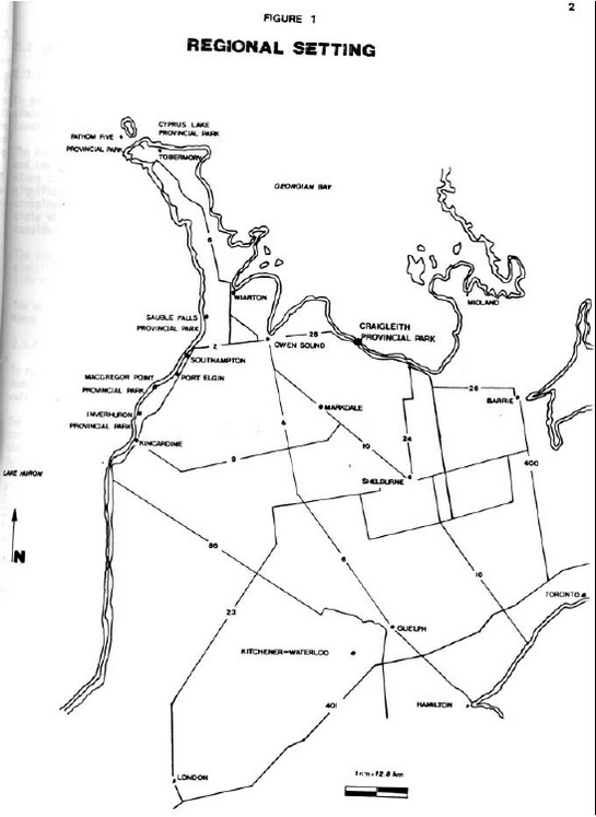
Craigleith Provincial Park is located on the Georgian Bay shoreline 10 kilometres west of the City of Collingwood with direct access from Highway 26 (Figure 1). The park provides 172 campsites, 40 of which have electrical hook-ups, and day–use parking for 138 cars.
The 66 hectare (162.33 acre) park was created in 1967 by Regulation 245/67, Schedule 59 under the Provincial Parks Act. The park consists of two parcels of land divided by Highway 26 and an abandoned railway line. The northern part is about 23 hectares (56.8 acres) and the southern parcel is 43 hectares (106.3 acres). At present only the northern property has been developed.
The park is underlain by bedrock from the Whitby Formation of the Ordovician Period (425 to 500 million years ago). The park is also underlain by the Lindsay limestone formation. This fossiliferous limestone dominates the park’s shoreline.
Inland, near the base of the slope of Blue Mountain are two remnant shorelines from postglacial lakes. The first, to the south of the park, was formed about 12,000 years before present by glacial Lake Algonquin. The second, at a lower elevation, was formed by glacial Lake Nipissing approximately 5,500 years before present. Between the Lake Nipissing shoreline and Highway 26 are flat–lying lacustrine deposits.
Several intermittent streams cross the park. They have incised channels into the soft shale and the lacustrine deposits due to the high spring runoff and the steep gradients of the Blue Mountain and the remnant shorelines.
The vegetation communities relate closely to the geology and topography of the area. The varying soil and moisture conditions contribute to the diversity of vascular plants. The clay slope is covered by a mixed forest type including red oak, sugar maple, white birch, balsam fir and white cedar. The lacustrine plain is composed of open fields of the park is dominated by white cedar, which has been supplemented by plantings of non–native species.
The park is rich in history. Evidence of the Petun Indians inhabiting the area dates back to the 1600s. From 1859 to 1863 a s hale oil works was operated within the present park boundaries. As well the steamer "Mary Ward" sank in 1872 off the shore of what is now Craigleith Provincial Park.
2.0 Park Policies
2.1 Classification
Craigleith Provincial Park is a recreation class park with facilities for camping and day–use activities. It provides opportunities for outdoor recreational activities in an attractive surrounding.
The recreational activities centre around the park’s main attraction, Georgian Bay. Sport fishing is good in the spring and fall. Swimming and boardsailing are popular in the summer months. The surrounding area also offers a number of recreational opportunities such as skiing, hiking, sailing, boating and spelunking.
As well, Craigleith Provincial Park is a recreation class park in the Niagara Escarpment Plan.
2.2 Goal
To maintain and operate Craigleith Provincial Park so as to provide the highest quality and variety of outdoor recreation opportunities for large numbers of people consistent with the capability of the natural landscape.
Figure 1: Regional Setting
2.3 Objectives
2.3.1. Protection
To protect regionally significant features of the natural and cultural landscape.
The contact between the Whitby shale and the Lindsay limestone which occurs along the shoreline is a regionally significant feature. The two out–croppings of the lower and upper Whitby shale which are present in the park are considered to be of local significance.
The clay slope forest complex has been classified as a regionally significant life science feature.
The park will be managed to protect these natural attributes.
2.3.2 Recreation
To provide day–use and facility–based camping opportunities in an area of outstanding recreational potential.
The park will contribute to achieving the recreational targets contained in the Owen Sound District Land Use Guidelines, 1983. Up to 170 additional campsites and ten additional day–use picnic tables may be provided by Craigleith Provincial Park by the year 2000 if demand is not met by the private sector. In 1986 the total park visitation was 41,725.
The Collingwood–Craigleith area is well known for its tourism opportunities and was designated as a "Four Seasons Recreational Area" by the Minister of Industry and Tourism during the late 1970s. The park visitor services program encourages visitors to enjoy local attractions.
2.3.3 Heritage Appreciation
To provide opportunities for exploration and appreciation of natural and cultural environments through interpretation and education based upon the character and significance of the park.
The park has some features of educational and interpretive value.
The bedrock exposures, fossils, remnant shorelines, and lacustrine deposits illustrate an interesting geological history.
The more recent human influence on this area and how it relates to the resources is another topic to explore. An example of this is the oil shale extraction works of 1859 to 1863.
Appreciation of these features will be encouraged through the visitor services program by means such as evening programs and self–use exhibits.
2.3.4 Tourism
To provide visitors with opportunities to discover and experience the distinctive environment of the park and the surrounding area.
The park will serve as a destination for tourists seeking camping and recreation opportunities in the southern Georgian Bay area. Craigleith Provincial Park will also serve as a stopover park for those travelling longer distances, providing day–use and camping opportunities.
The operating season for the park is early April to early November.
2.4 Zoning
Two types of zones will be designated to guide the management of the park (Figure 2):
- Development Zones (a) and (b)
- Natural Environment Zone
Development Zones
(a) Day–use and Camping Area
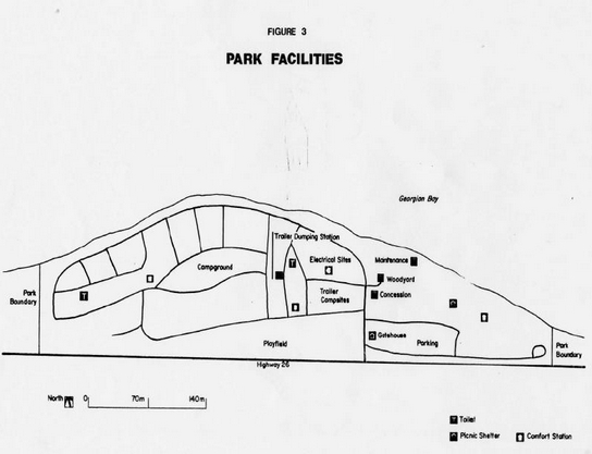
This area covers the entire section of the park north of the highway and is about 23 hectares (56.8 acres) in size (Figure 3). The area provides facilities for day–use and camping activities. This includes access roads, car and trailer campsites equipped with fire places and picnic tables, comfort stations, vault toilets, trailer dumping station, playing field, gatehouse, parking lot, picnic tables, residence/park office, maintenance and storage buildings and concession building.
Features of interpretive value within his zone include the abundance of fossils along the shoreline and the historic oil shale works.
Figure 2: Park Zones
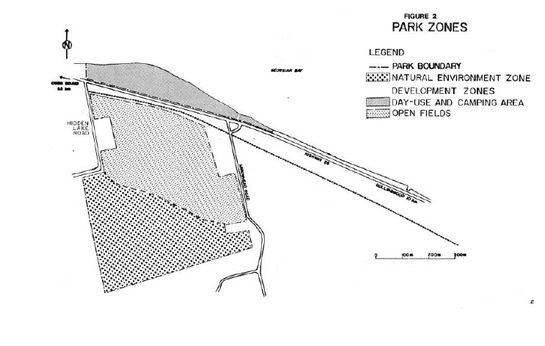
Figure 3: Park Facilities
(b) Open Fields
This area of about 21 hectares (51.2 acres) is located south of Highway 26 between the railway line and the foot of the Lake Nipissing remnant shoreline. It is a flat plain of lacustrine deposits made up of three abandoned agricultural fields. At present this area supports varying successional stages of vegetation.
Any future development that occurs at Craigleith Provincial Park will be established in this area. A septic tile bed will be built in a small part of this area. As well, this area would be the location of any new and/or relocated campsites and expanded – recreational facilities such as a swimming pool and a fitness trail. Future development in this zone will require an approved development plan and subsequent site plans.
Natural Environment Zone
This area, the clay slope forest, is about 22 hectares (54.4 acres) and is made up of the glacial Lake Nipissing reline and part of the plateau above the fragile, unstable nature of slope makes it sensitive to disturbance. The removal of vegetation will not be permitted in order to minimize soil slippage and vial erosion.
The interpretive value of this area is high. The Lake Nipissing shoreline is an example of the geomorphologic history of the area. The vegetation successional stages on the remnant shoreline are noteworthy.
Access to this area will be limited to walking trails only.
3.0 Resource Management
The park’s natural and cultural resources will be managed in accordance with the general planning and management policies for recreation class parks. Specific direction, where needed to meet the requirements of Craigleith Provincial Park, is provided below. Although the policies are presented in separate categories, all planning and management will recognize that the components are inter–related and that an integrated approach will be required in order for the park to achieve its objectives.
3.1 Vegetation
A Vegetation Management Plan will be developed for the park to outline future vegetation management for the park. The plan should include continued planting in the day –use/ camping area. Only native species representative of the local environment will be planted. As well trees may be removed for development or management purposes provided the removal is consistent with objectives related to visitor safety, aesthetics and conservation of natural and cultural values.
In the open fields of the Development Zone the Vegetation Management Plan should include the maintenance of the hedgerows because of their value as wildlife habitat and corridors; planting around the edges to act as a buffer, this is especially important along the railway line and where residences are located. As well planting in the fields should be considered to return them to a forested state. A variety of species should be planted in order to establish a diversified area.
In the Natural Environment Zone, the Vegetation Management Plan should indicate that only management related to visitor safety and conservation of natural values will be undertaken.
Commercial forest operations will not be permitted within Craigleith Provincial Park.
All fires except campfires within the park will be attacked aggressively by park staff and the local fire department to keep damage to an absolute minimum. Forest and vegetative insects and diseases that threaten values within the park will be controlled where feasible with minimal adverse environmental impact.
3.2 Wildlife
Hunting and commercial trapping will not be permitted within the park.
Limited authorized trapping (e.g. beaver) may be carried out, as required, for the purpose of protecting park values.
3.3 Fish
Sport fishing (e.g. rainbow trout and lake trout backcross) from the shoreline of Georgian Bay will be encouraged.
3.4 Landforms
The earth science features in the park will be conserved and protected.
The contact between the Whitby shale and the Lindsay limestone, which occurs along the shoreline, is a regionally significant feature. Fossils are abundant along the beach and are mostly from the Lindsay limestone. Removal of fossils from the park will not be permitted. The visitor services program and exhibits will encourage the observation of fossils without collecting.
Shoreline improvement work will only be undertaken if it will not destroy the feature or hinder the observation of it.
The outcrop of Whitby shale south of Highway 26 at Hidden Lake Road is of local significance. These exposures are re cognized for their educational and interpretive value.
The Lake Nipissing remnant shoreline within the park and the Lake Algonquin shoreline and the Niagara Escarpment, both south of the park are important features for interpreting the geological history of the area.
3.5 Cultural Resources
The area has an interesting history dating back to the 1600s when Petun Indians inhabited the area.
The early settlers' economy was very dependent on the natural resources. The industry included furniture manufacturing, limestone quarrying, extraction of oil from shale and shipping.
An information board and display will be used to convey historical information and the evening program schedule to the park visitors.
4.0 Client Services
4.1 Visitor Services
The Visitor Services Program will provide visitors with recreation opportunities related to understanding and appreciating the features in the park and the surrounding area as well as provide a window to local Ministry of Natural Resources integrated resource management programs. This will be achieved through the following components of a visitor services program.
4.1.1 Public Information
Information concerning park resources, management, facilities, programs and nearby points of interest will be available at key point s throughout the park (i.e. park office, main gate). Information will be provided through such means as a park newspaper tabloid, staff, display and notice boards and concession building. Self—use facilities such as the fossil display, historical plaques a nd signs will be made available to the park visitor. Visitor services programs will be provided during July and August.
Information about nearby features and attractions will be made available to the public.
4.1.2 Recreation
The recreation program will promote the visitor’s personal involvement in the park and surrounding area.
Recreation programs may include local tourist attractions and presentations by agencies and groups that relate to the enjoyment of the natural environment.
The park will provide opportunities for intensive recreational activities such as camping, picnicking, swimming, boating, fishing and open space playing. As well visitors will be made aware of opportunities outside the park such as hiking (Bruce Trail), beaches (Wasaga Beach), scenic drives (Beaver and Pretty River Valleys), canoeing (Beaver River) and boardsailing.
4.l.3 Interpretation
The interpretive program will seek to create a greater understanding of the natural and cultural values of the park. Aspects of the program will consider the geological and historical features of the park, which are of regional and local significance. They will be interpreted through printed material, self–use facilities such as displays, informal personal contact and visitor services programs.
4.2 Research
Scientific research by qualified individuals, which contributes to the knowledge of the natural and cultural features of the park, or recreational user statistics will be encouraged. 11 research programs will require the approval of the Ministry of Natural Resources.
4.3 Commercial Services
The concession building will continue to be operated to provide visitors with convenience foods, basic grocery supplies, ice and sundries. In addition to groceries, the building houses an information/bulletin board, a small geological display and a publication storage area.
The wood yard will be open for the daily sale of firewood at posted times.
4.4 Marketing
A marketing plan will be prepared to attract more visitors during low–use periods in the mid–week and spring and fall seasons, to increase involvement with the commercial sector by encouraging park users to use and take advantage of local tourist services and attractions, and generally stimulate interaction between the park and the private tourist and commercial sector in the vicinity.
5.0 Development
All development will be carried out in accordance with approved site plans and development plans.
The Owen Sound District Land Use Guidelines, 1983 indicate that 10 additional day–use picnic tables and up to 170 additional campsites will be provided at Craigleith Provincial Park by the year 2000.
If the demand for camping and day–use opportunities in the area increases and the private sector is unable to meet this demand, then the Ministry will consider expansion of Craigleith Provincial Park. Any expansion and development within the existing park boundaries will be carried out after consultation with local private camp ground operators, municipalities and the public.
Any expansion of park campsites would occur in the park area south of Highway 26 in the open fields. This would require the provision of an appropriate link to the day–use area and other facilities north of the highway and overcoming the perception that this would not be a desirable area to camp in, as it is further from the water.
Recent high water levels have created a serious problem along the shore line. A number of campsites and a road in front of them have been damaged. With high levels persisting, the day use comfort station, the maintenance building and additional areas in the campgrounds are being threatened. The damaged campsites will be closed until the hazardous lake levels drop again. Campsites will be established in the day use area as a temporary measure to maintain camping opportunities during this period of high lake levels. Also, appropriate erosion protection limited to protecting the maintenance building, day use comfort station and shoreline in front of the camping area is required to safeguard these facilities. This erosion protection work has been carefully site planned to minimize impact upon the regionally significant fossil beds along the shoreline.
The ground cover in the camping area is showing signs of damage due to the intensive use of this area. Little natural regeneration is occurring and planted stock is not faring well. Both of these conditions should be monitored.
If the problems of high water levels and/or difficulties with campsite rehabilitation persist then it may be necessary to reduce the number of campsites or to move some or all of the campsites to the open fields south of the highway. The result of moving all campsites would be to use the entire section north of the highway for day use only.
If the proposed pedestrian walkway system through the Craigleith/Campderdown area is established the park would be linked to it. Park facilities would be available to pedestrian traffic.
Now that the park is connected to the municipal water system a shower building will be built in the camp grounds. This will necessitate an expansion of the septic system. The new tile bed will be located south of Highway 26. The sewage will have to be pumped under the road from a holding tank built into the shower/comfort station building. At such time as a municipal sewage system becomes available, due consideration will be given to connecting the park to it.
In order to facilitate future development a number of specific plans should be prepared. These are a vegetation plan, a site development plan and an operations plan.
The park management plan will be reviewed in ten years following its approval or earlier if the need arises. As funds and priorities permit, additional research will be conducted on natural and cultural values and recreational user demands to provide a basis for future reviews of the plan.
6.0 Implementation
The management plan will be reviewed in 10 years following its approval, or earlier if the need arises. As funds and priorities permit, additional research will be conducted on natural and cultural values, and recreational user demands, to provide a basis for future reviews of the plan.
7.0 Public Consultation
The following steps were taken to incorporate public consultation in the preparation of the Craigleith Provincial Park Management Plan.
A mailing list was prepared consisting of interest groups, municipalities, government agencies and members of Parliament and the Legislature. Fifteen copies of the draft management plan were mailed out on July 28, 1986 with five responses being received by the August 28, 1986 deadline for public comment.
A news release was mailed out on July 24, 1986 and a newspaper advertisement was placed in the local newspapers during the last week of July 1986. These efforts were designed to inform people of the preparation of the management plan and that copies of the draft plan were available at the Owen Sound District Office and at the park.
The results of the various communication efforts were seven separate letters raising seventeen issues.
Based upon Ministry of Natural Resources staff discussions and external input, the final plan was prepared, approved and copies sent to the municipalities, members of Parliament and the Legislature and other interested parties.
References
Hills, G. A. A Ready Reference to the Description of the Land of Ontario and its Productivity, Ontario Department of Lands and Forests, 1959.
Ministry of Natural Resources. Ontario Provincial Parks Statistics, Parks and Recreation Branch, Queen’s Park, 1983, 1982, 1981, 1980, 1979, 1978, 1977, 1976, 1975, 1974, 1973.
Ministry of Natural Resources. Master Planning Directive for the Proposed Craigleith Provincial Park, Owen Sound District. December 1975 a.
Ministry of Natural Resources. Park Policy Direction Statement – Craigleith. 1975 b.
Ministry of Natural Resources. Ontario Provincial Parks Planning and Management Policies. 1978.
Ministry of Natural Resources. Craigleith Provincial Park – Acquisition Boundary, Land Ownership Inventory and Recommendations. Prepared by Walter Schmid, Owen Sound District, June 1979.
Ministry of Natural Resources. Craigleith Provincial Park Background Information, Owen Sound District. January 1985.
Ministry of Natural Resources. Craigleith Provincial Park Draft Management Plan, Owen Sound District. July 30, 1986.
Ministry of Natural Resources. Report of the Task Force on Parks System Planning. Parks System Planning Program. September 1981.
Ministry of Natural Resources. Owen Sound District Land Use Guidelines. 1983 a.
Ministry of Natural Resources. 1983 Provincial Park Camper Survey Summary Statistical Report. Outdoor Recreation Group. December, 1983 b.
Ministry of Natural Resources. "Fisheries Management Plan – Background Information". Owen Sound District. March 1983 C.
Ministry of Natural Resources. 1983 Provincial Park Day User Survey – Summary Statistical Report. Outdoor Recreation Group. December 1983.
Provincial Secretariat for Resource Development. The Niagara Escarpment Plan. July 1984.
Rahm, Linda. Market Area Analysis for the Proposed Pretty River, Craigleith and Kolapore Uplands Recreation Areas. Ministry of Natural Resources, Owen Sound. 1974.
Rhodes, 3. "A Reconnaissance Life Science Inventory of Craigleith Provincial Park". Ministry of Natural Resources, Southwestern Region. 1982.
Verma, Harish M. Geology and Fossils – Craigleith Area, Ontario. Ontario Geological Survey, Guidebook #7, Ministry of Natural Resources. 1979.