Craig’s Pit Provincial Park Management Statement
This document provides direction on the management of Craig’s Pit Provincial Park.
Regional Director’s approval statement
Craig’s Pit Provincial Nature Reserve
This revised Interim Manageme nt Statement will provide interim direction for the management of the above Provincial Nature Reserve until a comprehensive Park Management Plan is prepared.
This statement will provide the basis for the subsequent preparation of the Park Management Plan.
I am pleased to approve this Interim Management Statement.
M.S. Millar
A/Regional Director
North Central Region
Revised March 1991
Background information
- Date: 9.03.85
- Name: Craig’s Pit
- Class: Nature Reserve
- M.N.R. District: Terrace Bay
- M.N.R.Region: North Central
- Total area ha: 530
Land: [no information provided]
water: [no information provided] - Site region: 3W
- Site district: 5
- Date in Regulation: March 9, 1985
Life science representation targets
- Site type/landscape unit: Undocumented
- species/communities: [no information provided]
Earth science representation
- Geological theme: Timiskaming Interstadial
- Feature
- steep bluffs from former glacial Lake Minong.
- kettle features occur on relatively level sand/gravel deltaic deposit
Cultural resource representation
- Theme: Unknown
- Theme segment: [no information provided]
Recreation opportunities
- Day use: N/A
- Car camping: N/A
- Wilderness/back country: N/A
| Level/type | Reconnaissance/completion date | Detailed completion date | Required? |
|---|---|---|---|
| life science | field notes | N/A | N/A |
| earth science | Checksheet | N/A | N/A |
| cultural | N/A | N/A | N/A |
| recreational | N/A | N/A | N/A |
| other | N/A | N/A | N/A |
I Land tenure
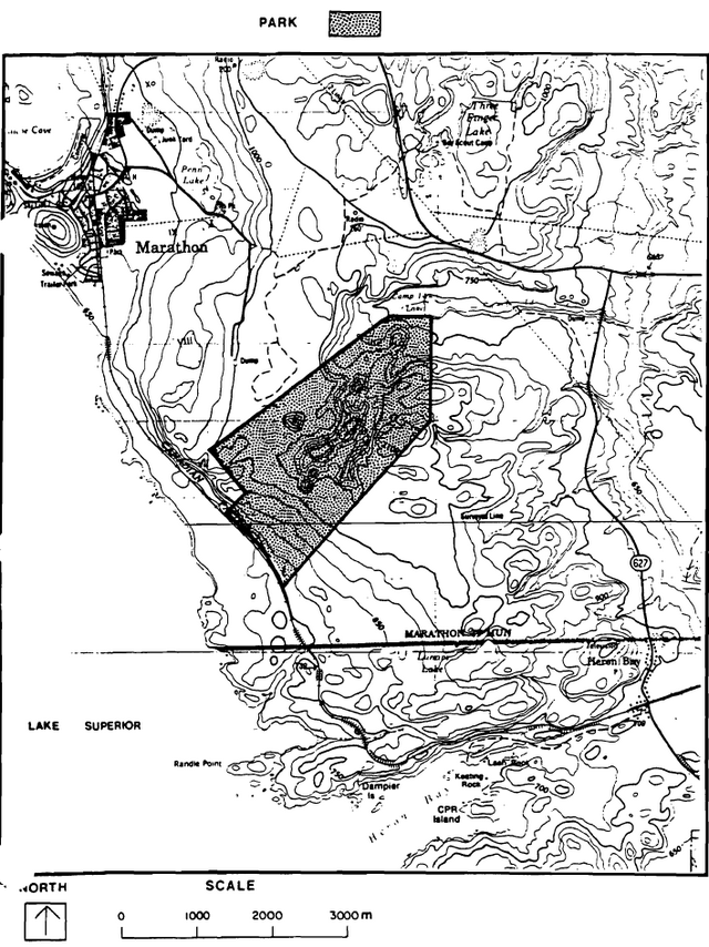
The entire Park area is located within the municipal boundaries of the Township of Marathon. The southwest Park boundary abuts both the Canadian Pacific Railway main line and a patented ballast pit used for track maintenance.
Guideline
Liaison with representatives from both the Township of Marathon and the Canadian Pacific Railway will be maintained, and their participation sought in future planning that may impact on the Park objectives.
II Land acquisition/disposition
N/A
III Existing/proposed development
Existing development consists only of several short, unmaintained former logging roads accessing close to the most prominent kettle hole.
Guideline
Road access to the Park will not be maintained by M.N.R.
No road improvement or general development will be permitted within the Park.
The Park boundaries will be surveyed and delineated on the ground.
IV Recreational activities
N/A
V Commercial activities
N/A
VI Natural resources
Craig’s Pit Provincial Park protects three representative earth science landform/process themes consisting of:
- glacial - two troughs and four major kettle holes;
- fluvial - deep deltaic deposits; and
- lacustrine - a distinctive wave-cut bluff.
These features were formed during the Timiskaming Interstadial time period and are important environmental indicators of the Minong and later lake stages in the Superior basin.
The bluff area is an important migratory bird watching area, where hawks gather in numbers, riding the updrafts created along the face of the bluff.
Mineral resource management
Mineral resources have not been documented.
Guideline
Mining will not be permitted within the Park.
Aggregate management
Aggregate extraction has occurred in areas adjacent to the Park.
Guideline
Aggregate extraction will not be permitted within the Park.
Vegetation management
A small part of the Park was previously logged.
Guideline
Commercial logging will not be permitted within the Park. Wildfire and insects/disease will be controlled, as required.
Wildlife management
Present hunting pressure Is considered to be moderate. High bluffs within the private C.P.R. ballast pit area and immediately adjacent to it, within the Park area, receive use as a migratory bird watching area.
Guideline
Hunting and commercial fur trapping will not be permitted within the Park.
The bird watching area outside the park has received listing as a sensitive area. The bluff area has been recognized as a potential wildlife viewing area in an MNR regional publication.
VII Cultural resources
Guideline
Cultural resources, as identified, will be protected from disturbance.
VIII Client services
Interpretation
Guideline
Interpretation will be conducted as minor, occasional theme of the Nays Provincial Park visitor services program.
Information
Guideline
A basic information leaflet will be produced providing information on access, significant resources, references, etc.
The Park area will be designated on provincially produced maps to clearly delineate boundaries.
IX Research/inventories
Guideline
Additional research inventories (earth/life science, cultural) will be encouraged to further document Park values, and may be carried out by M.N.R. or by outside interests.
Should inventories identify significant features; interim resource management plans will be prepared.
References/sources
Ontario Ministry of Natural Resources. 1983. Terrace Bay District Land Use Guidelines.
Craig’s Pit Provincial Park map