Darlington Provincial Park Management Plan
This document provides direction on the management of Darlington Provincial Park.
We are pleased to approve the Darlington Provincial Park Management Plan, as official policy for the management and development of this park. The plan reflects this Ministry’s intent to protect natural and cultural features of Darlington and maintain and develop high quality opportunities for outdoor recreation and heritage appreciation for both residents of Ontario and visitors to the Province.
M. Fordyce
Regional Director
Central Region
N. Richards
Director, Parks and Recreational Areas Branch
1. Introduction
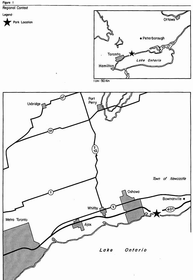
Darlington Provincial Park (hereafter referred to as Darlington or the park) is one of the Ministry’s most intensively used recreation oriented open spaces. This popularity results from its proximity to Oshawa and Metro Toronto and its ease of access for motoring tourists, being the only provincial park located immediately adjacent to Highway 401. Major attributes of the park include a wide range of developed facilities for day use and camping, direct access to Lake Ontario and a scenic landscape, including McLaughlin Bay. For 1982, the park had approximately 30,000 day visitors as well as a 65% campsite occupancy during July/August.
Darlington is situated on the north shore of Lake Ontario, in the Town of Newcastle (former Township of Darlington), Regional Municipality of Durham. The park is immediately adjacent to the eastern boundary of the City of Oshawa and approximately 65 km east of Metro Toronto.
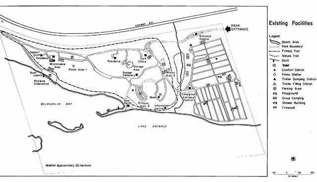
The park consists of 209 ha, 114 ha of which are land and 95 ha of which are water.
The park was acquired in two separate transactions. Most of the park was originally transferred to the Ministry of Natural Resources by the Ministry of Transportation and Communications in 1957. In 1963, McLaughlin Bay, on the park’s western side, was acquired from the Oshawa Hunt Club.
It is for the purpose of planning, development and management of the park’s natural, cultural and recreational resources that this management plan is being prepared.
2. Summary of significant issues and policy decisions
Severe shoreline erosion, predominantly along the park’s easterly shorebluff is causing substantial loss of land, threatening existing facilities and creating an unaesthetic shoreline. Endangered roads and campsites will be removed. Future development of permanent facilities will be kept back from the shoreline’s 100-year erosion line.
Expansion of the Oshawa Harbour is proposed out into Lake Ontario. It is anticipated that this location will have minimal environmental impact on Second Marsh and the park’s McLaughlin Bay.
Proposed industrial development of the Beaton Farm, immediately to the west of the park’s boundary, should have minimal effects on the park. Site planning measures have been adopted by the developers of Beaton Farm in consultation with the Ministry and other agencies in order to minimize the environmental and aesthetic impact of the proposal.
When the municipal services are provided for the adjacent proposed Beaton Farm industrial development, the park intends to investigate the feasibility of connecting its sewage handling facilities with this municipal facility.
Park user surveys reveal a growing user dissatisfaction with the swimming opportunities due to Lake Ontario’s water quality and temperature. Alternative swimming opportunities (e.g. swimming pool) will be investigated in the future.
Presently a service entrance to the park exists off of Wentworth Street East on the park’s west side. This street may be upgraded in the future in conjunction with the Beaton Farm development proposal. An interchange at the 401 highway, just west of the park, may also be provided. Park management will be considered when Wentworth Street is improved, the possibility of relocating the park’s main entrance to this location.
Figure 1: Regional context
Map: Existing facilities
3. Park policies
3.1 Park classification
The classification of Darlington is recreation
in recognition of the park’s outstanding recreational facilities and opportunities.
3.2 Park goal
To maintain and operate Darlington as a major urban recreation-oriented provincial park providing a wide variety of intensive and extensive outdoor recreational opportunities for the rapidly growing urban population of the Regional Municipality of Durham, as well as to provide stop-over camping facilities for the Highway 401 users. Recreational opportunities will be provided while protecting the park’s significant natural and cultural resources.
3.3 Park objectives
3.3.1 Recreation objective
The recreation objective of the Ontario Provincial Parks system is to provide outdoor recreation opportunities ranging from high-intensity day use to low-intensity wilderness experiences.
The recreation objective for this park is to provide year-round intensive and extensive outdoor recreation opportunities and facilities that utilize the area’s prime recreational resources, namely Lake Ontario, McLaughlin Bay and the land base.
- the park’s 350 campsites are estimated to represent 19% of the district’s campsite opportunities to the year 2000 (they presently provide 28% of the district’s camping opportunities),
- the park’s 152 metres of beach are estimated to represent 4% of the district’s swimming opportunities to the year 2000 (they presently provide 18% of the district’s swimming opportunities), and
- the park’s 300 day-use picnic tables are estimated to represent 12% of the district a picnicking opportunities to the year 2000 (they presently provide 24% of the district’s picnicking opportunities).
(N.B.) The difference in camping, swimming and picnicking percentile opportunities between present day and the year 2000, represents an estimated increase in the number of similar opportunities to be made available elsewhere and does not reflect any proposed decrease in facility based opportunities at Darlington.
3.3.2 Tourism objective
The tourism objective of the Ontario Provincial Parks system is to provide Ontario’s residents and out-of-province visitors with opportunities to discover and experience the distinctive regions of the Province.
The tourism objective for this park is to provide Ontario’s residents and out-of-province visitors, especially those travelling the 401 Highway, with camping/day-use opportunities and travel information in order that they can discover and experience this area of the province.
The park in 1979 contributed two and a half million dollars to the provincial economy annually through park expenditures and tourist spending. It is the objective of the ministry to maintain and possibly increase the economic contribution of this park to the local economy.
3.3.3 Heritage appreciation objective
The heritage appreciation objective of the Ontario Provincial Parks system is to provide opportunities for exploration and appreciation of the outdoor natural and cultural heritage of Ontario.
The heritage appreciation objective of this park is to provide a range of opportunities for the exploration, interpretation and appreciation of the natural features (i.e. McLaughlin Bay, Robinson Creek) and cultural resources (i.e. pioneer cemetery and log cabin) of the park.
3.3.4 Protection objective
The protection objective of the Ontario Provincial Parks system is to protect provincially significant elements of the natural and cultural landscape of Ontario.
The protection objective of this park is to protect the resources of the park through zoning that is sensitive to the particular resource management needs of the park’s features as well as to the recreational pressures placed on these resources. Two areas within the park that are particularly sensitive to adverse forms of development and recreational use are the McLaughlin Bay area as well as Robinson Creek.
3.4 Park boundary
There are no plans to alter the park’s present boundary. However, at some point in the future, additional land may be acquired to replace the parkland that is continually eroding away into Lake Ontario.
3.5 Zones and zone policies
All lands within the park will be zoned (see Figure 3) in recognition of their existing and potential environmental qualities, required protection and their potential for recreational and interpretive use within the context of the overall four objectives (see 3.3 Park Objectives).
3.5.1 Development zone (76 ha - land only)
This zone encompasses the majority of the park’s land base. Facilities for day use, camping, park maintenance/administration, and associated open space are located in this zone.
Development zone policies
- To improve the landscape aesthetics and the environmental quality of this zone, where possible (see Section 6).
- To maximize water-based day-use recreational opportunities by maintaining and improving upon existing resources/facilities and the provision of new facilities as deemed necessary.
- To improve the operational/maintenance efficiency and the recreational opportunities at the park; facilities will be upgraded, expanded, altered and relocated where necessary.
Figure 3: Zoning
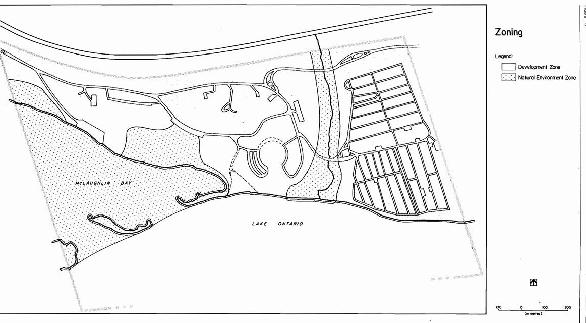
3.5.2 Natural environment zone (95 ha - land and water)
The two natural environment areas in the park contain aesthetic landscapes with sensitive natural characteristics. The two areas include:
- the narrow north-south running stream valley of Robinson Creek, which separates the campground area from the day-use area, and
- the western portion of the park including McLaughlin Bay, its sandpits, associated marsh/wetland and adjacent backshore areas.
Natural environment zone policies
- to protect through zoning and approved management procedures the natural features found in these areas from detrimental forms of development, management and recreational use.
- to allow appropriate forms of recreational activities to occur (e.g., hiking, sailing, waterfowl viewing, canoeing).
- to monitor these appropriate recreational activities to ensure no future detrimental impacts on the zone’s resources.
- to take approved management initiatives to improve and enhance the environmental qualities and resources found in these areas. Vegetation and Wildlife Management Plans will determine appropriate initiatives.
4. Resource management
4.1 Landform and water management
- shoreline erosion will be recognized as a natural process occurring as a result of the natural dynamics of Lake Ontario. Present day recommended methods for erosion control for such a long shoreline, are cost prohibitive. Any erosion control methods developed in the future, that are cost effective, may be initiated.
- dredging of McLaughlin Bay may be necessary at some point in the future in order assure recreational boating. The environmental implications of dredging will have to be assessed before any action is taken.
4.2 Vegetation management
- management of existing vegetation, proposed planting projects including a mowing program and wildlife habitat improvements will be addressed in a Vegetation Management Plan.
- park management will protect those significant vegetative communities and plants as identified in the park’s reconnaissance biological inventory (See Appendix A, A Reconnaissance Biological Inventory of Darlington Provincial Park in Darlington Provincial Park Management Plan - Background Information Document).
- the vegetative communities in the park will be allowed to evolve with minimum management interference, except for the following situations:
- management of existing specimen trees and forest cover in the campgrounds and day-use areas to ensure visitor safety, aesthetics and the long-term health of the tree (s).
- insects and diseases which do not threaten the existence of the plant communities will be allowed to develop undisturbed in all zones of the park.
- acceptable vegetative management procedures involve controlling native and non-native insects and diseases that threaten the values within the park as well as values outside of the park.
- where control is desirable, it will be directed as narrowly as possible to the specific insect or diseases as to have minimal effects on other components of the park’s environment.
4.3 Fauna management
- sport fishing will be encouraged in offshore park waters.
- commercial fishing and bait fishing will not be allowed in park waters.
- a controlled waterfowl hunt will be allowed on McLaughlin Bay within the boundaries of the park. No other hunting or trapping will be allowed. The waterfowl hunt is sanctioned through Regulation 49a, Schedule 23, The Game and Fish Act. A Wildlife Management Plan will be prepared to manage the waterfowl hunt. This plan will be included in the operating plan with emphasis on reducing the operating costs through a self-serve system and possible conservation club assistance.
- animal control, if necessary, may be carried out under the strict supervision of or directly by the Ministry of Natural Resources.
4.4 Cultural resources management
- preventive type of maintenance measures will be taken, as required, on the Pioneer Cemetery and the pioneer log cabin (Visitor Information Centre) to ensure their structural soundness.
5. Client services management
5.1 Visitor services
Darlington, as a major urban recreation-oriented provincial park, with close proximity to Highway 401, provides a wide variety of quality visitor services. Of the four visitor service components (communication, recreation, interpretation and outdoor education), the former two are emphasized at the park.
5.1.1 Communication
Objectives of this component should include the following:
- inform park visitors about the park, its services, facilities and management concerns
- inform visitors about recreation and interpretive opportunities in the local area
- inform visitors of the role of the Ministry of Natural Resources
- instill a sense of respect in visitors for the park environment
- provide a means of feedback for visitor to communicate to the Ministry of Natural Resources
A comprehensive information component will be provided catering to the needs of special user groups such as the urban day users and tourists travelling on the Highway 401 corridor (especially the first time tourists to Ontario). The pioneer cabin will be utilized as an information and display centre dispensing tourist, park and ministry information via publications and signage. This information centre may also be supported by the Central Ontario Tourist Association.
The objectives outlined above will be achieved through all or some of the following: publications, signage, audio visual presentations, displays, mass media and personal contact involving campsite visitation.
5.1.2 Recreation
A variety of self-use and staff-led recreation activities will be provided:
- Darlington has a high potential for self-use recreation with a waterfront for sunbathing, swimming, boating and fishing. As well, self-use recreation can occur on the park’s nature trail, fitness trail and open landscaped areas. Winter opportunities exist as well for skating, cross-country skiing and tobogganing.
- limited staff-led recreation activities will be provided as funds and staff priorities permit. They may include campfire, craft and water oriented programs. Such programs should lead to an involvement with the natural and cultural features of the park.
- to supplement the park’s recreation facilities a free recreation equipment loan program may be offered.
5.1.3 Interpretation
The following is a list of themes that will be interpreted:
Local settlement history
On-site features to aid this theme include the Pioneer Cabin, artifacts and Pioneer Cemetery.
Resource management
- the history of the park’s land base from original forest cover to agricultural fields and back to natural and planted forest cover, Lake Ontario Fishery, dynamics, of shoreline erosion and control, changing environment of McLaughlin Bay and changing sand spit configuration.
All of the above themes can be interpreted in publications, evening programs, special events and interpretive facilities.
5.1.4 Outdoor education
Local and regional school boards will be encouraged to make educational use of the park’s resources.
5.2 Recreation management
- the park operating season is one of the longest in the region; from mid-May to mid-October.
- the park will be managed to optimize its recreational potential, especially water-based opportunities.
- existing facilities will be upgraded and additional ones provided, as needed, to enhance and maximize the recreational opportunities of the park.
- During off-season, when the park’s facilities are closed, visitors have access to the park’s land base for recreational pursuits (e.g. walking, waterfowl hunting and viewing, skating on McLaughlin Bay, skiing, sledding, snowmobiling [in campground area only] etc.).
5.3 Commercial services
The following existing commercial services are available at the park:
- wood concession
- boat rentals (canoes, paddleboats, rowboats, sailboats)
- fast food/store
Additional concessions may be added or existing ones modified in some way, according to the district parks and recreation section in conjunction with the park superintendent, as well as in keeping with park goals and objectives.
5.4 Marketing
The following is a ranking of common Provincial Park marketing strategies, listed in decreasing order of importance, as they apply to Darlington.
- hold present customers longer.
- to increase midweek camping and day use.
- repatriate customers lost during the rowdyism of the 70’s.
- attract day users who will stay in local service accommodations and use local services.
- expand demand for camping by encouraging visitation to other Ontario Provincial Parks as well as to private campgrounds.
- increase day use where high volume (i.e. groups) can be achieved.
- continued use of outside groups for special events.
Marketing and operational initiatives, as outlined in the “Marketing Manual for Darlington Provincial Park”, and working in close association with other tourist organizations, will be implemented in order to obtain the above results.
6. Development and implementation
Though the park has a diverse and fully developed range of facilities, the following development proposals are justified in order to:
- improve the efficiency of operating/maintaining the park
- upgrade existing facilities
- accommodate increased use
- contribute to the district target for day-use recreation opportunities.
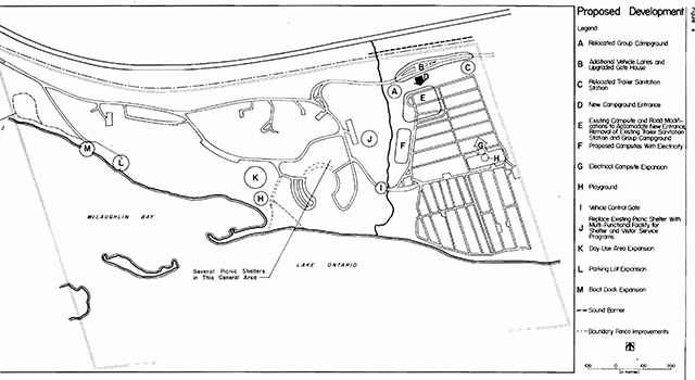
Campground and day-use development proposals in descending order of priority (refer to Figure 4):
- development of a new trailer sanitation station located east of the main park entrance.
- additional entrance lanes and upgraded fee collection facilities and gatehouse at main park entrance.
- modification to campground layout including newly located access road into campground; removal of some existing campsites and roads; removal of existing trailer dumping station; new campsites and internal roads where old group campground is and to the south; and provision of new group campground.
- hiking trail on western side of park in the wetland area (may require boardwalks).
- installation of day use and campground playground equipment.
- expansion of hydro sites.
- replace existing fencing around the northern boundary of the park along the C.N. railway tracks.
- develop facilities to enhance waterfowl viewing opportunities on the sandspit.
- erection of sound barriers along the north boundary in the vicinity of the campground. The design and material (structural or earth) of the barrier is yet to be determined.
- replace existing picnic shelter in area #2 with a multi-functional facility that will lend itself to visitor [missing text]
- extend and upgrade existing boat-launching ramp and increase the number of docks (approximately three 4m lengths each).
- several picnic shelters (actual number to be determined by site plan) in day-use area to be located in north area of picnic area #3.
- expansion of parking lot in boat-launching area east of the existing lot to accommodate approximately 50 cars and trailers.
- day-use expansion west of picnic area #3.
The following two development items are listed separately since they will require special funding and special approval (see Summary of Significant Issues and Policy Decisions Section 2).
- park sewage hook-up with an expanded Oshawa system.
- swimming pool.
- preparation of a Vegetation Management Plan and a Wildlife Management Plan will be given top priority.
Figure 4: Proposed development
7. Public consultation
Public consultation focused on the local area and included:
- a news release and advertisement in the Oshawa Times, and the Bowmanville Statesman advising that this management plan was available for review at the park and/or district office. A news release only was submitted to Oshawa This week.
- copies of this plan were forwarded to local levels of government for review [Chamber of Commerce (Oshawa, Bowmanville), Town Council of Newcastle, City Council of Oshawa, Regional Council of Durham, Central Lake Ontario Conservation Authority]
- copies of the news release were sent to interest groups (Second Marsh Committee, Oshawa Model Power Boat and Airplane Club, Iburist Association of Durham Region, Federation of Ontario Naturalists and the Ontario Federation of Anglers and Hunters).
- where appropriate, contact will be made with adjacent landowners, by park management, to inform these landowners of the plan and its contents
- announcements and posters were on display in the park advising park visitors of availability of plan for review
All comments and suggestions received from the public were considered while finalizing this plan. This management plan will be reviewed when major issues surface and at least once within the next ten years. Any necessary plan amendments will be made with public involvement in accordance with apparent needs.
8. References
Burn, J. A.; Archaeological Survey of Darlington Provincial Parks, Department of Lands and Forests.
Cecile, C.P.; Oshawa Second Marsh Baseline Study, Interim Report, Integration and Interpretation of Ecological, 1981, Environment Canada.
Crowe, McKay, Baker; The Tourist and Outdoor Recreational Climate of Ontario, Volumes 1, 2 and 3, 1977, Fisheries and Environment Canada.
Martin, Lindsay; Pioneer Family Research - Darlington Park, 1971, Department of Lands and Forests.
Ontario Ministry of Natural Resources, 1982 Provincial Park Day Visitor Survey - Summary Statistical Report, 1983, Outdoor Recreation Group.
Ontario Ministry of Natural Resources; Lindsay District Land Use Guidelines, 1983.
Ontario Ministry of Natural Resources; Darlington Provincial Park Management Plan - Background Information Document, 1984.
Ontario Ministry of Natural Resources; 1982 Provincial Park Camper Survey - Summary Statistical Report, 1983, Outdoor Recreation Group.
Suddard, Gwen; Visitor Services Report Darlington, 1975.