Driftwood Provincial Park Management Plan
This document provides direction on the management of Driftwood Provincial Park.
Cette publication est egalement disponible en francais.
Approval statement
We are pleased to approve this Management Plan for Driftwood Provincial Park. lt is a statement of policy for the protection, management and development of park resources. It also provides guidance for the preparation of plans for resource management, natural heritage education and development to implement park policies and achieve park objectives.
Barton Feilders
Planning & Research, Manager
Ontario Parks
Date: July 12, 2000
Adair Ireland-Smith
Managing Director
Ontario Parks
Date: August 17, 2000
Statement of Environmental Values under the Environmental Bill of Rights
The Ministry of Natural Resources’ Statement of Environmental Values (SEV) was prepared in accordance with the provisions of the Environmental Bill of Rights (EBR). It describes how the purposes of the EBR are to be considered whenever decisions are made which might significantly affect the environment
The primary purpose of the EBR is to protect, conserve and, where reasonable, restore the integrity of the environment
. From the MNR’s perspective, that broad statement of purpose translates into four objectives in its SEV:
- to ensure the long term health of ecosystems by protecting and conserving our valuable soil, aquatic resources, forest and wildlife resources as well as their biological foundations;
- to ensure the continuing availability of natural resources for the long-tern benefit of the people of Ontario;
- to protect natural heritage and biological features of provincial significance; and,
- to protect human life, the resource base and physical property-from the threats of forest fires, floods and erosion.
The Ministry’s SEV has been considered throughout the preparation of this Management Plan. The Management Plan for Driftwood Provincial Park will further the objectives of managing Ontario’s resources on an ecologically sustainable basis.
1.0 Introduction
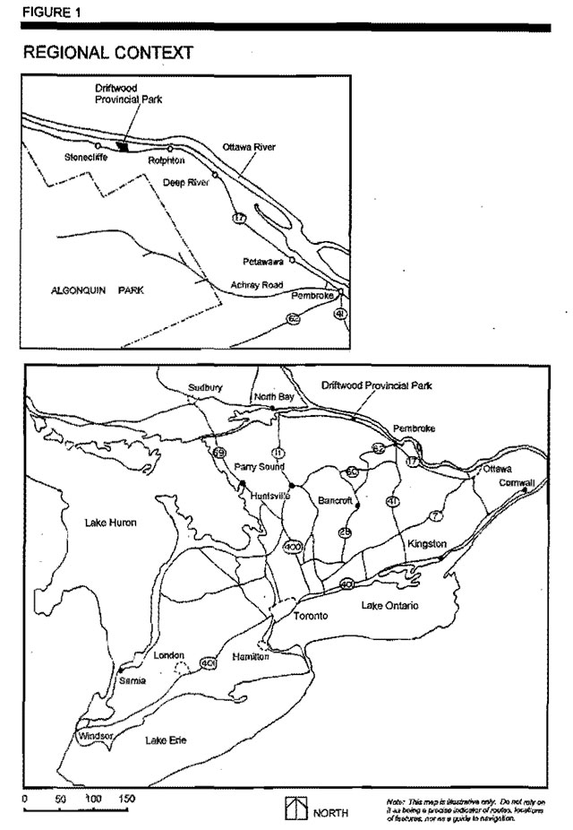
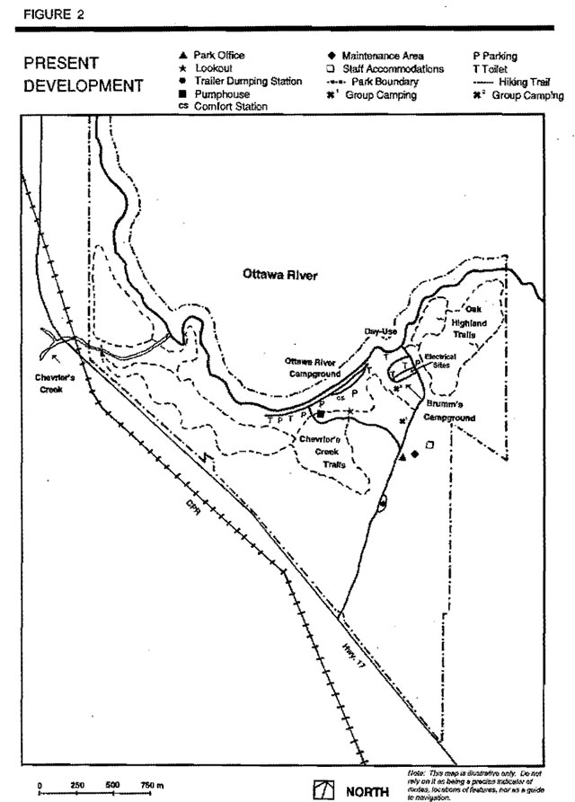
Driftwood Provincial Park is located 72 kilometres southeast of Mattawa, 20 kilometres northwest of Deep River and 66 kilometres northwest of Pembroke (Figure 1). The park encompasses 422.3 hectares of land with 2 kilometres of scenic Ottawa River shoreline. Situated adjacent to Highway 17, the park provides camping and day-use opportunities for area residents and tourists travelling along the Trans-Canada Highway. The majority of its 79 campsites are concentrated along the Ottawa River shoreline (Figure 2). The day-use area provides picnicking facilities and a boat launch to access the waters of the Ottawa River for boating and angling. The parks trail system, which extends along the shoreline and a relict dune ridge, offers many picturesque views of the Ottawa River. The park’s day-use area is directly opposite the mouth of the popular Dumaine River, whitewater canoeing river in Quebec. Although the park’s location renders it more of an over-night camping area, its scenic amenities and facilities are building Driftwood Provincial Park’s reputation as an appealing destination park.
Driftwood Provincial Park was originally reserved in 1951 for reforestation purposes following a fire in the 1930s. The park began operating in 1957 and was placed into regulation in 1963 by Regulation 117/63. In 1998, under Regulation 167/98, a 123.3 hectare addition to the park increased the area to 422.3 hectares.
Medisedimentary bedrock outcrops with intrusions of pegmatite and diabase dikes can be found in the park. This is typical of the Ontario Gneiss Segment of the Grenville Province. The surficial deposits are related to the withdrawal of the last ice sheet. The glacial deposits are mostly till with local fluvial sand and gravel occurrences.
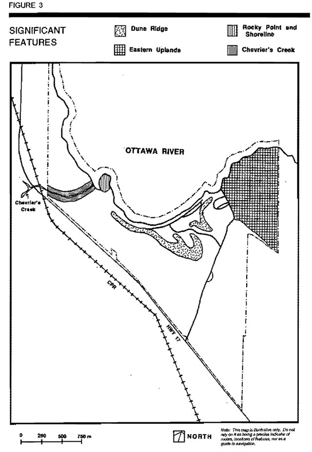
The most significant geological feature in the park is a relict dune ridge, situated in back and and parallel to the Ottawa River (Figure 3). lt rises almost 30 metres in height at some points. Other features include a diabase dike, an ice-push ridge and evidence of tectonic activity on the Ottawa Bonnechere Graben in Ontario and Quebec in the Laurentian Hills.
Driftwood Provincial Park’s forest consist primarily of species such as trembling aspen (Populus tremuloides) and largetooth aspen (Populus grandidentata), particularly in the south end of the property. Jack pine (Pinus banksiana), White pine (Pinus stobus) and hardwoods become more prevalent along the ridge. Further west, red oak (Quercus rubra) thrives on the rocky uplands of the park. The variety of forest communities, the exposed rocky shorelines and the wetlands provide good interpretive opportunities.
An extensive forest fire burnt through the southern part of Driftwood Provincial Park in 1975.This burnt area and the pattern of regenerated forest are of interpretive interest. In addition, the park has significant life science features such as leatherwood (Dicra palustris), while ash (Fraxinus americana) and bur oak (Quercus macrocarpa)which are approaching the northern limit of their range.
2.0 Classification
Driftwood Provincial Park is classified as a recreation park under the provincial park classification system.
Recreation parks are areas which support a wide variety of outdoor recreation opportunities for large numbers of people in attractive surroundings. (OMNR, 1992)
Driftwood Provincial Park provides a number of attractive campsites concentrated along the shoreline of the Ottawa River. The park’s existing recreation opportunities contribute to the achievement of the recreation targets outlined in the Pembroke District Land Use Guidelines and to the provincial park system objectives.
3.0 Goal
The goal of Driftwood Provincial Park is to:
Provide a variety of outdoor recreation opportunities in the Ottawa River Valley for bath destination and short stay visitors.
In addition, as one of three perimeter parks to Algonquin Provincial Park, Driftwood could also provide information on the recreation and interpretive opportunities in Algonquin Park.
4.0 Objectives
Driftwood Provincial Park will contribute to the achievement of protection, recreation, heritage appreciation and tourism objectives of the provincial park system.
4.1 Protection
To protect the park’s aesthetic attributes and natural features.
The existing locally significant features (e.g. dunes, headlands and liver shoreline) will be maintained. There are no known provincially significant natural or cultural features within the park.
Management programs will be implemented to sustain the natural attributes of the campground, beach and picnic areas. New development will be implemented with minimum impact on park aesthetics and natural vegetation cover.
4.2 Recreation
To provide day-use recreation opportunities in the scenic Ottawa River Valley.
To provide facility-based camping opportunities along the shoreattd immediate vaney side of the Ottawa River.
Driftwood Provincial Park provides seasonal recreation opportunities such as car camping, day use, picnicking, swimming, hiking, canoeing, boating, and angling. Individuals, families and groups will have every opportunity for social interaction in attractive natural surroundings.
Driftwood Provincial Park will contribute toward the achievement of the park program’s recreation targets by offering the above listed opportunities.
4.3 Heritage appreciation
To provide opportunities for exploration and appreciation of the natural and cultural environment of the Ottawa River Valley through interpretation and education based upon the character and significance of the park.
The natural landscapes in Driftwood Provincial Park, in combination with its location along the Ottawa River, afford natural appreciation of the area. The park setting also lends itself well to interpreting the agricultural, logging, and flood history of the area. Driftwood Provincial Park will provide unstructured opportunities tor exploration and appreciation of natural and cultural environments through selfguided trails and information. Some special events or programs will encourage heritage appreciation and recreational activities (Section 8.1).
4.4 Tourism
To facilitate travel by residents of and visitors to Ontario who are discovering and experiencing the distinctive regions of the Province.
Driftwood Provincial Park will provide day use and camping opportunities for stopover and destination visitors. Driftwood also offers an excellent opportunity through Its shoreline sites and extensive trail system to enjoy the scenic beauty of the Ottawa River Valley in this part of Ontario.
The estimated gross economic impact of visitor and park operating expenditures for the 1996/97 fiscal is $1.48 million (OMNR, 1998). Backcountry use along the east side of the Ottawa River, in the vicinity the Dumoine River, contributes to the variety of recreation use and potential of the area.
5.0 Park boundary
The park boundary is shown in Figure 2. In 1998 under Regulation 167/98, there was a 123.3 hectare addition to the park. The park encompasses 422.3 hectares which includes waters and shoreline on the Ottawa River.
6.0 Zoning
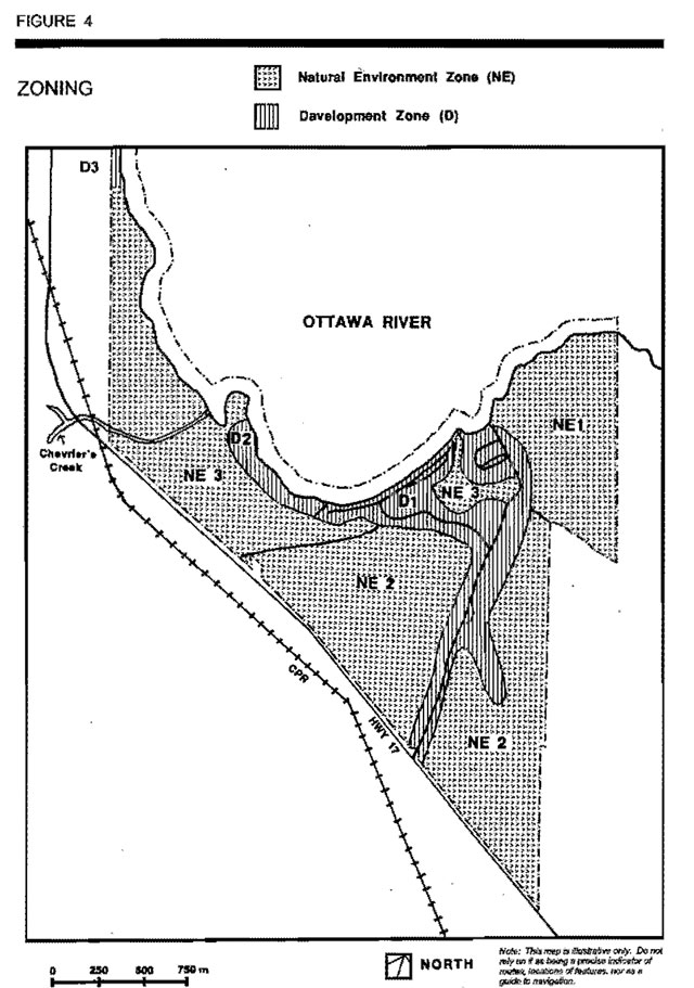
Recreation parks may contain five possible land use zones: access, development, nature reserve, natural environment and historical. Each zone permits certain land uses and outlines park management strategies. Through zoning policies, recreational areas are provided while features of biophysical and cultural significance are protected. Driftwood Provincial Park has been divided into two zones: development and natural environment (Figure 4).
6.1 Development zones (total 80 ha)
Development zones provide facilities and services for a wide range of day-use and camping activities. Driftwood Provincial Park has three distinct development zones (Figure 4):
- D1 - the Ottawa River Zone is the largest (60 ha) containing most of the existing development
- D2 - the Ottawa River Shoreline Zone is a much smaller area (18 ha) set aside for possible future development; and,
- D3 - the Remote River View Zone (2 ha) is a small portion of regulated park lands, currently under two (2) Land Use Permits (LUPs) which lie to the north and are separated by a wetland from the main body of the park. The two LUPs provide two commercial resorts with direct access to the Ottawa River. The LUPs are compatible with park operations and they have the ability to create revenue for the park.
Ottawa River, D1 (60 ha)
This zone includes two campgrounds; the day use area and associated services. It extends to the entrance (south) of the park to encompass the access roads, the park office, wood yard and trailer dumping station. This zone incorporates the comfort station, pumphouse, electrical sites, group camping area, staff house (trailer) and maintenance facilities (Section 9.1, 9.2 & 9.4). The proposed staff quarters will be constructed in this zone. (Section 9.3)
Ottawa River shoreline, D2 (18 ha)
The Ottawa River Shoreline Development Zone joins the Ottawa River Development Zone (D1). The possibility for walk-in campsites or campground expansion will be investigated along the undeveloped shore west of the existing Ottawa River Campground (Section 9.4).
Remote River View, D3 (2 ha)
This zone is located north of the core of the park and is separated from the rest of the park by a wetland. This small portion of regulated park land is currently under two (2) Land Use Permits (LUPs). A portion of a building from a commercial resort is located on the property. LUPs, with rigid conditions, were approved tor the commercial tourism operation. The LUPs provide the commercial resort operators with access to the Ottawa River.
6.2 Natural environment zones (total 342.3 ha)
Eighty percent (80%) of the park is zoned natural environment (342.3 ha) in recognition of the features that exist in these areas of the park. Although park and area surveys have not identified any provincially significant geological, biological and cultural features, natural environment zones include aesthetic landscapes in which there is a minimum amount of development required to support low intensity day use recreational activities. Permitted uses will consist primarily of interpretive facilities such as trails, signs or displays. There are three distinct natural environment zones (Figure 4):
- NE1 - Eastern Rocky Uplands,
- NE2 - Fire Regenerated Forest; and,
- NE3 - Forested Valley Side.
Eastern Rocky Uplands, NE1 (80 ha)
Located on the east side of the park, exposed grey banded megmatitic biotite gneiss is predominant. This bedrock was formed by the deposition of ancient ocean bottom sediments that were later metamorphosed.
Fire Regenerated Forest, NE2 (152.3 ha)
The higher and rugged terrain provides several scenic lookouts of the Ottawa River, the Laurentian Hills in Quebec and the mouth of the Dumoine River. The Laurentian Hills were formed when a section of the earth’s crust vertically shifted up thousands of metres during mountain building activity on the Ottawa-Bonnechere Graben. The Ontario shoreline subsided during this same tectonic activity and a narrow dike of diabase (black rock) was injected into the ancient metasediments during faulting and earthquakes that occurred after the Graben was formed.
This rocky upland supports a variety of vegetative communities including forest stands, open rocklands and a wetland. The exposed bedrock creates a very harsh, dry environment where thin soils allow only scattered growth. Blueberry (Vaccinium augustifolium), sweet fern (Comptonia peregrina) and bush honeysuckle (Diervilla lonicera) are the major species. In some areas where bedrock is exposed, only associations of mosses and lichens are able to survive. Red oak and staghom sumac (Rhus typhina) grow on the bedrock ridges that parallel the shoreline of Holden Lake. Further inland, white pine and jack pine are associated with red oak. Deeper soils, between the bedrock ridges, support forests dominated by trembling aspen and largetooth aspen or poplar. White birch (Betula papyrifera), red maple (Acer rubrum) and red oak occur as frequent associates.
In a trough between the rock ridges, beavers (Castor canadensis) have flooded out a portion of the forest. This has created a large pond with standing dead trees, an ideal wildlife viewing area. The dead trees provide nesting habitat for tree swallows (Tachycinata bicolor) and woodpeckers (Picade family). In the spring, a variety of frogs and salamanders breed in the pond, Wood ducks (Aix sponsa) and blacks (Anas rubripes) have been observed in the pond and are common here in the fall. Recently felled poplar around the shoreline indicates that beaver still inhabit the site.
The trail offers scenic lookouts over the Ottawa River and provides an excellent opportunity to view wetland plants and associated wildlife (e.g. beaver, marsh birds). A small portion of regulated park lands, currently under two (2) Land Use Permits, lie to the north and are separated by a wetland from the main body of Driftwood Provincial Park (Figure 2).
In this zone, at the south end of the park (adjacent to the Highway), visitors see evidence of trees that survived the 1930s forest fire but the majority of the current plant community is a direct result of the regrowth after that fire. Species such as firewood (Epilobium anquistifolium), blueberry, brachen (Pteridium aquilinum) and pin cherry (Prunus pensylvanica) were among the first to invade the area. These are found in the nutrient-rich ashes left by the fires and clear open spaces, a favourable environment. Stands of trembling aspen, largetooth aspen and white birch are competing with red and jack pine in the open spaces on the site. The groves of young aspen provide food for a variety of wildlife, such as deer (Odocolleus virginanus), moose (Alces alces), ruffed grouse (Bonasa umbellus), beaver and snowshoe hare (Lepus americanus). The blueberry sweet fern barrens provide ideal foraging areas for a variety of songbirds, particularly during migration periods.
Standing dead trees also provide nesting and feeding areas tor many spades. Insect-eating birds, such as woodpeckers, nuthatches (Sittidae family) and warblers (Emberizidae family) are common in this area. This forest is a result of a forest fire. The Chevrier’s Creek Trail extends through this zone (Figure 2) providing interpretive opportunities of these natural features (Section 9. 7).
Forested Valley Side, NE3 (90 ha)
A forest dominated by large white pine occurs in the western portion of this zone. The pines average 0.8 mattes in diameter and rise to over 30 metres. This is one of the most aesthetic stands in Driftwood. A wide diversity of other species occurs scattered among the white pine. These include red pine (Pinus rasinosa), basswood (Tilia americana), white ash, hemlock (Tsuga canadensis), black spruce (Picea mariana), balsam fir (Abies balsamea), eastern white cedar (Thuja occidentalis), trembling aspen, largetooth aspen, ironwood (Ostrya virginiana) and sugar maple (Acer saccharum). Aster (Aster macrophyllus), sarsaparilla (Aralia nudicaulis), mountain maple (Acer spicatum) and Leatherwood (Dirca palustris L.) (a small shrub approaching the northern limit of its range) dominate undergrowth. Leatherwood is of interpretive and cultural value, since its flexible twigs were once used by the Aboriginal people for bindings and lacing. Located near the mouth of Chevrier’s Creek, bur oak is another less known species for this northern latitude.
Chevrier’s Creek flows through the middle of this zone. Although the creek is too small for canoeing, the rushing water and abundant rapids create a picturesque setting. A variety of aquatic communities also occur along the creek. A beaver dam at the head of the creek created a pond, now overgrown with sweet gale (Myrica gale), bur-reed (Sparganium americanum), and various types of sedges (Carex). The length of the creek is lined with such species as black ash (Fraxinus nigra), yellow birch (Betula alleghaniensis) and balsam fir. Thickets of speckled alder (Alnus rugosa) occur at the confluence of the creek and the Ottawa River.
The most significant geomorphological feature (regional significance) in this zone and the park is a steep sided ridge ranging from 15 to 30 metres in height. The ridge which parallels the Ottawa River has sinuous form extending in an east-west direction (Figure 3). While the ridge is a sand deposit shaped like an esker, closer analysis has led geologists to believe that it may be a relict dune system, modified by wind action. It originated from a large sand plain surrounding a post-glacial lake, Brennan Lake which once occupied the Ottawa Valley. Once the glacial meltwaters drained sufficiently, the sand plain was exposed to wind action which deposited sand in the dune ridge and was stabilized by colonizing and forest vegetation.
The Chevrier’s Creek Trail extends through the NE3 Zone (Figure 2) providing scenic lookouts (Section 9.6) and interpretive opportunities (Section 8.1 & 8.7). Site planning will evaluate this trail system to address environmental concerns and to improve recreational opportunities. (Section 8.2).
7.0 Resource management policies
Management of the resources within Driftwood Provincial Park will be implemented in accordance with the Management Plan and conform to the Ontario Provincial Parks Planning and Management Policies tor a recreation class park.
A provincial land use planning initiative, initially called Lands for Life, commenced in 1997 to Identity various land use allocations and use management policies on Crown land in central Ontario. Although the recently completed Ontario’s Living Legacy Land Use Strategy (1999) does not make any changes to Driftwood Provincial Park’s resource management policies there is a new provincial park (Ottawa River, P131, 2,376 ha) adjacent to Driftwood. A description of this new park and prevailing policies are provided in the Ontario’s Living Legacy Land Use Strategy (1999).
Changes to provincial park policies as a result of the Land Use Strategy that concern trapping and baitfish management do not affect Driftwood Provincial Park as there are no traplines or baitfish licenses within the park.
7.1 Land management
The relict dune ridge (regional significance), that extends along the back shore area, is included primarily within the Eastern Rooky Uplands Zone (NE1). Development on the ridge will be limited to minimal interpretive facilities such as trails that support low-intensity recreational activities. Trail development will be limited to the top of the ridge and any trail entrances leading up the ridge will be monitored and managed for erosion problems (Section 9.2).The access road and some facilities are located on the section of the ridge included within the Ottawa River Development Zone (D1). Further facility development in D1 will comply with stability and sensitivity of the ridge.
No mining or mineral exploration will be permitted within the park. Sand or gravel required for major maintenance and capital improvements will be brought in from external sources.
7.2 Vegetation management
A Vegetation Management Plan will be developed for the park. No commercial harvesting of timber will be permitted in the park. Removal of trees for development or management purposes may be used for park purposes.
The Vegetation Management Plan will have different prescriptions for each zone as outlined.
Natural environment zones
Vegetation in these zones will be allowed to follow a natural process of succession and may be altered only for the purposes of trail development, safety, the establishment of viewpoints, or aesthetic enhancement along the park entrance. The long term risk of forest fires to the safety of park visitors and other adjacent values to the park will require fire suppression according to the Fire Area Strategies for the land base.
Development zones
Permanently closed campsites will be rehabilitated and some over used sites may be closed periodically for rehabilitation. Plant screens will be maintained between operating campsites. Native plant species and or structures that withstand uses of campsites are preferred. Stand improvement programs, in the campgrounds, will be employed as required to maintain a mixed age overstorey. Forest fires within the park will be suppressed.
Insects and diseases altering forest and vegetation values inside or outside the park may be controlled. Biological controls will be used in preference to chemicals, were feasible. Where control is desirable, it will be directed so as to have minimal environmental impact.
7.3 Fisheries management
The Ottawa River and its tributaries provide excellent opportunities for sport fishing. The Ontario and Quebec Governments regulate angling in these areas. Angling will be permitted in accordance with applicable regulations for the season, catch and possession limits.
7.4 Wildlife management
Due to the limited size of the park and the extensive hunting opportunities the surrounding area, hunting will not be permitted within the park.
Protection of park resources, property as well as the safety of visitors may require the trapping of select animals. This will be carried out under the supervision of Ministry personnel.
7.5 Water management
The quality of drinking water will be maintained to provide standards by the park’s water treatment and water quality sampling program.
The beach area in Driftwood Provincial Park is subject to debris accumulation as a result of river currents and prevailing winds. Fluctuations in water levels (daily or seasonal) occur as a result of the Des Joachims Dam, located 2 kilometres downstream. While both problems affect the water quality for recreation, the Ministry of Natural Resources has no control over them and as such must deal with them as part of the normal maintenance program.
7.6 Fire management
Approved methods of fire detection and suppression will be implemented to protect life, property and park resources. Fire management in the park will be based on the Fire Area Strategies for the land base.
8.0 Operations policies
Driftwood Provincial Park has a variety of natural resources which can provide excellent recreational and tourism opportunities. This Management Plan outlines the future development of the park resources as well as operational policies. The existing park Operating Plan will be reviewed to ensure that they are consistent with approved Ontario Provincial Parks Minimum Operating Standards. The Operating Plan provides the necessary information required to operate the park on a day-to-day basis. The plan includes topics such as budget, staffing, maintenance schedules, enforcement and emergency procedures. Operations policies address natural heritage education, recreation management, tourism services, marketing, and the park’s Business Plan. These are described in the following subsections. The park Operating Plan will be kept current as park infrastructure and services change.
Driftwood Provincial Park is operated to provide services during the peak season. Driftwood’s operating season is a minimal “peak season” operation. The operating season will be reviewed in the future in the parks business planning process.
8.1 Natural heritage education
A Natural Heritage Education Plan will be prepared with guidelines for self-use service. Special programs or guest speaker events may be scheduled for park interpretation purposes (PM 6.02). The Natural Heritage Education Plan will identify approaches to inform park visitors of the natural, cultural and recreational resources of the park, the local Ottawa Valley area, Algonquin Provincial Park, Ottawa River Provincial Park (P131) and the provincial park system. The Natural Heritage Education Plan will also outline the park services, facilities and rules.
Natural heritage education will consist of the following components: information, interpretation and recreation.
Information
Information on the natural and cultural resources of the area will be available in the park office, through handouts, displays and special events. Permanent self-use displays or signs may be used to educate visitors about significant features along trails. Cultural resources information such as local history, and local events and activities will be provided in brochures or displays. Information on recreation trails, hunting, angling in the local area, and recreational opportunities in the central Ottawa Valley, including Algonquin Park, will be available. Information regarding park programs, facilities and rules will be provided in the gatehouse/office, park brochure and by park staff.
Interpretation
Driftwood Provincial Park has interpretive potential. A variety of historical, life and earth science themes are represented here. The Ontario Parks Zone Natural Heritage Education Plan will identify park themes in context with this part of Ontario. Park interpretation will focus on self-use activities, primarily taking advantage of the extensive trail network. Special programs or guest speaker events may be scheduled for interpretation purposes.
Many themes are represented in Driftwood Provincial Park. These include locally and regionally significant heritage themes.
Surficial features such as the sand ridge (or relict dune) are locally significant. Bedrock features found in the Ottawa-Bonnechere Graben, a huge valley fault system are provincially significant but are better represented beyond the park. Vistas in the park allow visitors to view this valley fault.
The major life science theme is the effect of fire on the ecosystem. Fire is a natural process which may be influenced by land use. The gradual return of the forest in the park after a fire in 1975 can be interpreted to reveal the fundamental story of forest fire succession in the pine lands of the Ottawa Valley.
Driftwood Provincial Park contains historical resources such as local settlement history. This history is represented by features such as a former colonization road (the road to the beach), old farmsteads (which were flooded when the Des Joachims Dam was created downstream on the Ottawa River), and an old survey post. This square wooden post is located along the old road which runs north from Highway 17 toward Chevrier’s Creek in the western portion of the park. The post appears to be the original survey marker between Lots 23 and 24 in Head Township.
The Ottawa River has played a major role in the early history of Ontario. Driftwood Provincial Park can be used to explore such themes as the voyageurs and early explorers, the days of the huge log drives and the recent construction of the Des Joachims Dam (and subsequent shoreline flooding). The park has acquired an authentic river lug for interpretation of this aspect of river use. The feasibility of restoring the river tug for park use will be investigated. Natural heritage education, in consultation with site planning, will identity an appropriate location for a dry dock. Potential partners will be approached to help define and achieve this project.
Recreation
Programs may be offered by park staff and interested groups and agencies to develop the outdoor skills of park visitors. Programs such as canoeing, backcountry travel and camping, angling and bird watching may be provided according to the Natural Heritage Education Plan.
8.2 Research
Scientific research, by qualified individuals, that contributes to the knowledge of natural and cultural history and to environmental and recreational management, will be encouraged in the park. Ontario Parks will encourage institutions to undertake research projects. Research that may be used to enhance the operations of the park and the delivery of natural heritage education programs will also be encouraged. All research programs will require the approval of Ontario Parks and will be subject to park policy and other applicable Legislation. Ontario Parks may approve the research of any natural or cultural specimens by qualified researchers. All such materials removed remain the property of the Ontario Ministry of Natural Resources. (Ontario Provincial Parks Planning and Management Policies, 1992; PM2.45 & PM2.45.01)
8.3 Recreation management
The two trails in Driftwood Provincial Park, the Chevrier’s Creek Trail and the Oak Highland Trail, will receive regular maintenance and management. The trail system will be monitored for safety and environmental concerns. Due to the proximity of the Chevrier’s Creek Trial to the campgrounds, a number of unofficial trails (footpaths) have been created, causing gullying on the steeper slopes. Site planning will evaluate and redesign the trail system, as needed, to eliminate those footpaths and restore eroded slopes. To facilitate winter access and augment cross-country skiing, trail extensions may be developed in the southern section of the property (Section 9.6).
Motor vehicles and motorized snow vehicles, as defined in the Highway Traffic Act may be permitted on designated park roads or trails except where development, management or emergency purposes are required by Ministry personnel. The Park Superintendent will monitor this.
Groups (e.g. boy scouts, girl guides, and other organized clubs) will be permitted in the group camping area and must receive pre authorization from the Park Superintendent (Section 9.4). Group size will be determined according to the carrying capacity of the designated site.
Driftwood will cater to persons and groups travelling off of the Ottawa River from river trips such as the Dumoine.
8.4 Tourism services
Driftwood Provincial Park provides information to those travelling the Trans-Canada Highway. It may serve to market parks further east and west along the route (Section 8.5). Driftwood Provincial Park functions as a perimeter park to Algonquin Provincial Park, providing additional overflow camping facilities as well as providing information concerning Algonquin’s facilities and recreational opportunities. Driftwood’s location along the Ottawa River plays another tourism role through the promotion of the river’s recreational opportunities and recreational services (e.g. outfitters, boat rentals).
The shore lands of the park will be evaluated for potential support to area tourism services (e.g. day use and overnight access). Through Land Use Permits two small portions of fragmented lands north of the main body of the park will be available to local private sector tourism operators.
8.5 Marketing
Driftwood Provincial Park has become a popular stopover area along the Trans-Canada Highway as well as an attractive destination park. Approaches to enhance access to the park including water access from the Ottawa River will explored.
A Marketing Plan for the park will be developed to provide direction in marketing Driftwood for its potential beyond that of a perimeter park lo Algonquin. This will include promoting viewing of the natural and cultural features of the Ottawa Valley, boating and canoe access to and from the Ottawa and Dumoine Rivers, angling opportunities, group camping and the park’s shoreline campsites. Park brochures will be supplied to other provincial parks and communities east and west along the Trans. Canada Highway.
A Sign Plan will be developed for the park. This will include the design for a new park entrance at Highway 17 (Section 9.1).
A Park Store
for retailing park merchandise will be integrated into the park office. Providing services to attract visitors (e.g. electrical sites, comfort station) will enhance long term campsite leasing.
9.0 Development policies
Development policies use the resources of the park to allow for further recreational activities and interpretation opportunities while protecting the parks natural features. Development will proceed in accordance with the policies of this approved Management Plan, Management Policies, Provincial Park Development Standards, and approved site and development plans. In all instances, approved detailed site plans will precede all development. The requirements of the Environmental Bill of Rights, the Environmental Assessment Act and other pertinent acts will be adhered to.
The development policies recognize that the Ottawa River is the main attraction for most visitors, but development of the shoreline- requires consideration of environmental constraints. It is anticipated that the proposed improvements and heritage ideas, listed within this Management Plan will attract more use to the park and complement area tourism initiatives.
The future development plans for the park are illustrated in Figure 5 and are described in the following sections:
9.1 Access and circulation
The current entrance to Driftwood Provincial Park does not portray an effective image to highway travelers. Site plans for a new park entrance will be prepared, including improvements to the general appearance of that immediate area.
In the interest of safety, turn-in lanes have been added to Highway 17 for both east and west bound traffic. A new park sign will be erected at the park entrance to attract the attention of passing motorists and to better express the nature and character of the park. The park entrance corridor will be appropriately signed and the roadway marked with shoulder and centre lines.
The entrance road will form a one-way traffic loop at the park office to create a circular drive. This will provide tor more parking, allow more effective traffic control and increase maneuverability for large trailers.
9.2 Administrative and operation facilities
The location of the existing administrative and maintenance facilities are inadequate. The existing park office will be renovated to provide more space for administrative functions.
9.3 Facility renovation/upgrading
Garbage
Solid wastes are transported, by park staff, to the local municipal dump or removed through a recycling program.
Utilities
Utility lines or rights-of-way will be developed as required for servicing new infrastructure in the park. Site-specific inventories and corridor plans will be prepared as required in order to ensure that impact on the park’s natural, cultural and recreational values are minimized.
Staff facilities
The staff quarters are located in the trailer behind the park office. New staff quarters may be constructed, according to site planning, to replace the temporary existing staff quarters (trailer).
9.4 Campground facilities
This Management Plan makes provision for upgrading facilities in the existing campgrounds and for campground expansion. Campground expansion may occur if: site demand increases; campsites are closed for the purpose of rehabilitation and require replacement; and if sites are removed as a result of negative aesthetics.
Ottawa River campground
The Ottawa River Campground currently has 61 sites, the majority of which are located along the shoreline. A comfort station with showers and laundry facilities is located here. This campground may be expanded if there is a demand tor additional sites or a need to replace inferior sites in other areas of the campground. Site planning will evaluate extension potential of this campground in a westerly direction toward the point Campground expansion will be contingent upon demand, site evaluation and planning as well as the consideration of environmental constraints such as flood hazard, slope stability and erosion.
Vacationing families are the largest category of visitors at Driftwood Provincial Park. Playground facilities (e.g. creative play structures, swings, badminton net and horseshoe pit) may be provided to make the park more enjoyable. Hiking trails will be extended and clearly signed to provide for more family use.
The feasibility of developing a boat mooring facility on the south end of the campground will be evaluated. Depending on the results of this study, such a facility could be developed in this campground o to reduce the potential for conflicts between beach users and for safety reasons of property protection.
Walk-in/boat-in sites
Walk-in sites and/or optional boat in campsites will be developed in the Ottawa River Shoreline Development Zone (D2), separate from the western end of the Ottawa River Campground. There are a number of potential sites which will be evaluated through site planning. If campground expansion is required, this area will be considered for development and the designated walk-in/boat-in campsites may be displaced. In the event that this occurs, proposed site planning will evaluate the feasibility of walk-in/boat in campsites to be relocated to the far end of this expansion area.
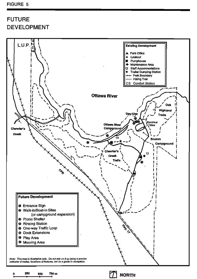
Brumm campground
The top of the ridge in the Brumm Campground has eighteen (18) campites and offers scenic views of the Ottawa River. These sites have access to the day-use beach. Electrical sites are located in this campground. If the Ottawa River Campground is considered unsuitable for westerly expansion (based on site planning), campground expansion may occur depending on demand and site planning, in the Brumm Campground. This campground may be an Ideal location to establish long term lease sites for seasonal visitors.
Group camping
There are two group camping areas. The first is located just off the entrance road, hallway between the park office and Brumm Campground and the second is in the southwest corner of Brumm Campground, leading to the day use area. Associated facilities such as toilets and a parking lot will be provided.
9.5 Day-use and east shore facilities
Day-use facilities are located along the shore on the east side of the park (below Brumm Campground). The grassy area behind the beach contains change houses, washrooms, water taps and picnic tables. A picnic shelter has been proposed in the back shore area to provide shelter for day users in all seasons. A rinsing station will be installed in the day use area to reduce the problem of swimmer’s itch.
The present docking system is used regularly by boaters. Use will be monitored and boat slip extensions and perhaps a pumping station may be required.
Boat-in day-use and overnight camping will be marketed with a provision for use of the park shore lands. Boaters will be encouraged to prevent the spread of exotic species (e.g. zebra mussels) by inspecting boats, trailers and equipment. Publications (e.g. brochures, posters) on prevention may be available.
9.6 Recreation facilities
Driftwood Provincial Park: has potential for trail development as it has many scenic viewpoints and interesting natural features. The Chevrier’s Creek Trail and the Oak Highland Trail provide visitors with the opportunity to appreciate the park’s natural and scenic amenities. A sign plan will be developed for the existing trail system for both summer and winter use. Regular trail maintenance will be required.
The Oak Highland Trail introduces visitors to the most rugged area of Driftwood Provincial Park. The trail starts at the present day-use parking lot and proceeds north-eastward along tile rocky uplands to view tile scenic Ottawa River, tile mouth of tile Dumoine River and the Laurentian Hills in Quebec.
The Chevrier’s Creek Trail starts at the old Brumm homestead and extends to the south and western ends of the property. Visitors will have the opportunity to experience a variety of forest communities as well as the scenic viewpoints along the dune ridge. Modifications to the Chevrier’s Creek Trail have been proposed to enhance hiking (and potential cross-country skiing) in the park. Trail extensions may occur ant to Highway 17 (Figure 5). Locating a trailhead in the vicinity of the Highway will facilitate winter access and the extra trail length may improve the trail system.
9.7 Natural heritage education facilities
Self-use interpretive facilities may be provided in the park to meet the needs of the visitors and the park’s goals and objectives as outlined in the Natural Heritage Education Plan.
The trail system within the park offers settings lo illustrate a variety of earth and life science interpretive themes. The Oak Highland Trail reveals the early geological history of Driftwood Provincial Park and can also be used to interpret the biological life in wetlands and forests. The Chevrier’s Creek Trail has a variety of interpretive opportunities and is a longer and more accessible trail. Historical interpretation can highlight the old Brumm Family Homestead and tile flood history of tile Ottawa River. The effect of fire on the ecosystem, aquatic and terrestrial vegetative communities and unusual species (leatherwood and bur oak) can be incorporated into life science interpretation along this trail. Visitors may enjoy brochures and stand alone displays as trail guides while viewing earth science features such as the dune ridge or biological processes like plant succession related to historic fires.
A Natural Heritage Education Plan, integrated with marketing Ideas for the park will outline priorities to enhance recreation and education services.
10.0 Implementation strategy
The Driftwood Provincial Park Management Plan will be reviewed on an as-needed basis to determine whether the plan is still relevant. This Management Plan may be amended at any time, should the need arise. All amendments will conform to the guidelines prescribed in the Ontario Provincial Park Management Manual (1994). Meanwhile, the development of facilities as described in this Management Plan (Section 9.0 & Figure 5) will proceed and are based upon the availability and allocation of normal budget and capital funding each year.
Projects
Phase 1
Completion of this phase will provide basic guidelines for future development & operations.
- prepare park Operating Plans.
- prepare a Natural Heritage Education Plan.
- prepare and implement site plans and services to cater to day-use and camping use originating from Ottawa travellers.
- establish partners to develop a river tug restoration feasibility study. Depending on a positive outcome of the study a program plan will involve partners to restore and use the liver tug.
- prepare a Sign Plan.
- develop a Vegetation Management Plan.
Completion of this phase will provide basic facilities to encourage a more stable and positive financial contribution to the provincial park system.
- construct a new trailer dumping station in the development zone.
- install new entrance sign and appropriately sign and mark the park highway corridor (e.g. paint lines on pavement)
- develop plans to construct staff quarters.
- construct a play area in the development zone (D1).
- complete the site planning to establish walk in sites (or expand Ottawa River Campground it further car camping sites are required) and implement accordingly.
- develop a Park Marketing Plan
- evaluate the feasibility of developing boat slip extensions to the existing dock at the day-use and a mooring area adjacent to the campground.
- provide a rinsing station at the day-use and campground
- develop and implement site plans for the Chevrier’s Creek Trails & the Oak Highland Trails.
- monitor camping demand and if necessary complete site planning to establish suitable areas for campground expansion for the Ottawa River Campground.
- construct a one way traffic loop to create a circular drive at the park office.
- improve signs along trails, plan and establish ski trail extensions
- renovations of the park office to provide more space for administrative functions.
10.1 Social and economic impact analysis
Driftwood’s visitation has fluctuated in recent years with the campgrounds averaging 53% occupancy during the peak July-August 1997 operating season, 46% in 1998 and 58% in 1999.
Expenditures made by Ontario Parks to operate Driftwood, and by park patrons who visit the park, translate into economic impacts (figures related to visitor expenditure drawn from the 1998/99 Park User Survey). Based on an initial total expenditure of $675,000 the following economic impacts were generated using the Social and Economic Impact Modal, (SEIM) licensed to MNR:
- Regional Gross Sales (or Regional Gross Output) - $1,645 million
- Wages & Salaries - $523,000
- Provincial Person Years of Employment - 17.4
- Regional Person Years of Employment - 16.9
Driftwood is an important part of the region’s tourism infrastructure. Development of hiking trails, upgrading of the day-use area, improvements to the campgrounds (e.g., more campsites on the Ottawa River) will result in increased recreational activity in the park including shoulder season use.
The projects and activities identified in this Management Plan contribute to the social and economic wellbeing of the surrounding area.
11.0 Summary of public consultation
The Preliminary Management Plan was completed in 1986 and in the subsequent public consultation phase, tabloids were handed out to campers, adjacent landowners and local municipalities. There were a variety of responses relating to the resource management development and operations proposals for the park. The majority of respondents were local tourist operators who expressed some concern regarding Increasing competition once the park upgrading was completed. A meeting was held on October 6, 1986 in Stonecliffe with the Council of Head, Clara and Maria Townships, as well as representatives from the Mountain River Tourist Association and Mountain River Outdoor Club to address these concerns. The discussion clarified the reasons for facility upgrading (to bring the park on par with provincial park standards), and campground expansions (to replace sites removed for rehabilitation), and assured local tourist associations that their needs were being considered in the Management Plan. Following the meeting no further correspondence was received.
As noted in the Introduction, a number of factors contributed to the interruption of the planning process. During the ensuing period, a number of minor changes were made to the draft text and the Preliminary Management Plan was re-released in March 1998. However, the overall goal of the park remains the same: to provide recreational opportunities for both destination and transient visitors.
These changes were made in light of further analysis of site capability and operating needs.
Throughout the planning process there was continuous public consultation and the following steps were taken:
- Preliminary Management Plan was re-released in March 1998
Mailing list
- Provincial Interests in the Mandatory Mailing List in provincial park policy (PM 11.02.02) including specific municipal
- First Nations
- local tourist operators
- adjacent landowners and local municipalities/ Townships
- local residents and businesses
- persons who request to be included on the mailing list
- a notice indicating plan approval and where copies may be obtained was mailed to mailing list members.
Media ads
- media ads in the following papers: North Renfrew Times and Up River News
Several positive media articles were released as well as a letter, from the Townships of Head, Clara and Maria, to the Minister supporting the operation of the park and its value to the area.
Public meetings
- October 6, 1986 in Stonecliffe with the Council of Head, Clara and Maria Townships, as well as representatives from the Mountain River Tourist Association and Mountain River Outdoor Club.
- in 1996-1997, Township meetings and meetings with tourist operators and the general public were held.
- public meetings, on request, were held over the duration of the project.
Environmental Bill of Rights (EBR) Registry
- EBR notices were posted which provided the opportunity for public comment
During the management planning process public comments were received. Many verbal comments were received as well as written responses. All comments received were considered during the completion of this Management Plan.
12.0 References
Gillespie, J.E., 1964. Soil Survey of Renfrew County Report No. 37, Department of Agriculture, Ottawa
Noble, T., 1983. Biophysiographic Analysis, Site Region 5E, Algonquin Region. Queen’s Park.
Ontario Ministry of Natural Resources, July 1999. Ontario’s Living Legacy Land Use Strategy. Queen’s Printer for Ontario.
Ontario Ministry of Natural Resources. Ontario Parks. Jan. 1998. The Economic Impact of Ontario Parks: A Summary Report for Fiscal 1996/97, Peterborough.
Ontario Ministry of Natural Resources, 1992. Ontario Provincial Parks Planning and Management Policies, Queen’s Park.
Ontario Ministry of Natural Resources, 1987. Ontario Provincial Parks Management Planning Manual, Parks Planning Section, Toronto.
Ontario Ministry of Natural Resources, 1983. Provincial Park Day User Survey Summary Statistical Report, Parks Planning Branch, Toronto.
Ontario Ministry of Natural Resources, 1983. Provincial Park Camper Survey Summary Statistical Report, Parks Planning Branch, Toronto.
Ontario Ministry of Natural Resources, 1983. Pembroke District Land Use Guidelines, Regional Lands Office.
Ontario Ministry of Natural Resources, 1979. Driftwood Provincial Park Master Plan. Huntsville.
Ontario Ministry of Natural Resources, 1977. Ontario Provincial Parks Landscape and Design Principles and Guidelines, Parks Planning Section, Toronto.
Ontario Ministry of Natural Resources, 1975. Background Information, Pembroke District, Huntsville.
Ontario Ministry of Natural Resources, Development Standards Manual, Toronto.
Rowe, J.S,, 1972. Forest Region of Canada. Canadian Forestry Service, Ottawa.
Spek, C.M., 1979. A Brief Earth Science Study of Driftwood Provincial Park, Ontario Ministry of Natural Resources, Huntsville.
Wilson, H., 1987. Rivere Dumoine: A Comprehensive Guide for the Adventuring Canoeist. Northern Concepts, Temagami.