Eagle Lake Islands Conservation Reserve Management Statement
This document provides policy direction for the protection, development and management of the Eagle Lake Islands Conservation Reserve and its resources.
June, 2003
Dryden District
Ministry Of Natural Resources
Approval statement
We are pleased to approve this Statement of Conservation Interest for the Eagle Lake Islands Conservation Reserve (C2340).
This Statement of Conservation Interest will provide guidance for the management of the Conservation Reserve and form the basis for ongoing monitoring of activities. More detailed direction is not anticipated at this time. Should significant facility development be considered or complex issues arise requiring additional studies, more defined management direction, or special protection measures, a more detailed Conservation Reserve Management Plan will be prepared with full public consultation.
The Eagle Lake Islands Conservation Reserve will be managed under the jurisdiction of the Dryden Area supervisor, Dryden District, Ministry of Natural Resources.
Signed by:
R.G. McColm
Dryden District Manager
Ministry of Natural Resources
Date: June 30th, 2003
Signed by:
Charlie Lauer
Regional Director
Northwest Region
Ministry of Natural Resources
Date: March 7th, 2016
1.0 Background information
The purpose of this document is to identify and document the natural heritage values of the Eagle Lake Islands Conservation Reserve, the activities that occur there and, through a set of management guidelines, lay out the activities that will and will not be permitted. For more information regarding this Statement of Conservation Interest (SCI) please refer to the “Conservation Reserve Policy and Procedure PL3.03.05”.
| Name | Eagle Lake Islands Conservation Reserve (C2340) |
|---|---|
| Site Region / Site District | 4S-4, 4S-5 |
| OMNR Administrative Region / District / Area | Northwest Region / Dryden District / Dryden Forest |
| Total Area (ha) | 3,395 ha |
| Regulation Date | Anticipated for 2003 |
| First Nations | Ojibway Nation of the Saugeen Band, Wabigoon Lake Ojibway Nation, Aboriginal People of Wabigoon, |
| OBM | See Appendix |
| Lat./Long. | 49' 42 N / 93' 15 W |
| Basemap | 20 15: 4600 55100, 4700 55100, 4700 55000, 4800 55000, 4800 55100, 4900 55100, 4700 54900, 4800 54900, 4900 55000, 4900 54900, 5000 54900, 4900 54800, 5000 54800 |
| General Location Description | The reserve encompasses most of the 490 +/- islands consisting of Crown land on Eagle Lake. It is located approximately 40 kilometers west of the City of Dryden. |
| Access | There are a number of private and public boat launches on Eagle Lake. A boat (or snowmobile in the winter) can be taken from one of these to any of the islands on the lake. |
| Life science representation |
Upland Forest/Forested Dunes: ~1/3 of forest is dominated by balsam fir Conifer Mixedwood – balsam fir, jack pine, trembling aspen, white birch, black and white spruce Pure and mixed jack pine forest, pure and mixed red pine stands. White pine scattered throughout. Scattered cedar stands. Wetland: Poor conifer swamp and poor fen fringed with thicket swamp (speckled alder, lake sedge) and tall shrub shore fen (bog birch, sweet gale, leather leaf, wire sedge, marsh cinquefoil) Animal Species: Moose, deer, bear, bald eagle, beaver, cormorants, mallards, mergansers, American white pelican, turkey vulture, sharp-shinned hawk, numerous song bird species, wood frog |
|---|---|
| Earth science representation |
Bedrock: The Wabigoon fault runs through the reserve. North of fault: metasedimentary rock of the Warclub group, migmatitic and granitic equivalents South of the fault: 3 types of volcanic rock; basalt flow (volcanic) rocks commonly pillowed, dacitic to rhyolitic rock, and massive, pillowed basalt rock. On the fault: bands of sedimentary rock interlayed with the pillowed volcanics. Granitic rocks of the Atikwa batholith intrude the lower part of the greenstone belt. Surficial Geology: Silty clay deposits are dominant throughout central Eagle Lake. Thin ground moraine overlies bedrock on higher ground. The Eagle-Finlayson end moraine can be found directly northeast of the reserve. |
| Cultural value representation | The reserve contains a number of sites where Native artifacts, pictographs, burial sites, fur trading posts and places of worship have been located. |
| Recreational opportunities | Recreational opportunities exist for fishing, general water sports, snowmobiling, hunting, camping and nature activities. |
Figure 1: General location of the Eagle lake Islands Conservation Reserve.
| Survey Level | Life Science | Earth Science | Cultural | Recreational |
|---|---|---|---|---|
| Reconnaissance |
|
|
|
|
| Detailed |
|
|
|
|
2.0 Values to be protected
This section provides a description of the key natural heritage values on the site, their condition relative to past resource and management activities, and their sensitivity to future land use and management activities.
| Life Science |
|
|---|---|
| Earth Science |
|
| Cultural |
|
| Aboriginal | Pictographs, artifact sites, places of worship and fur-trading posts |
| Tourism | 24 tourist operators on lake (primarily on mainland) |
| Recreational Fishing | Permitted; |
| Recreational Hunting | Permitted; WMU #8 (some in 7B) |
| Trapping | Permitted; DR05N03501, DR04N03201, DR05N01601, DR04N03101, DR04T01901, DR04N01301, DR04T01801, DR04N01701, DR04N01401, DR03N00401 |
| Bear Management Area | Permitted; DR:7B-107, 08-016, 08-003, 08-004, 08-002, 08-007, 08-008, 08-015, 08-023, 08-014, 08-027, 08-025 |
| Bait Harvesting | Bait fish Block #s: 497932, 496932, 496931, 495932, 495931, 495924, 494931 |
| Commercial Fishing | N/A |
2.2 Values to be protected
The intent of this SCI is to protect the following values by establishing management guidelines for existing and potential uses in this area given the level of past disturbance and the nature of the existing features.
2.2.1 Forest values
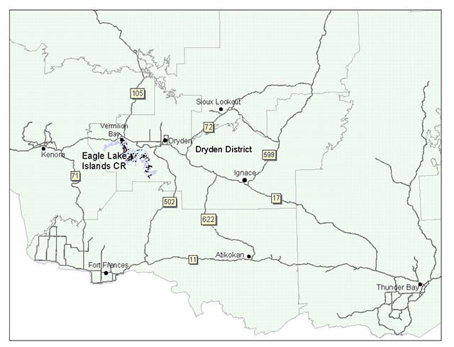
The reserve provides provincially significant representation of conifer, conifer mixed and deciduous mixed forests on lacustrine sediments in Ecodistrict 4S-4 and 4S-5. Additionally, critical representation of sparse forest exists here. Individual red and white pine scattered throughout the reserve may exceed 120 years of age representing old-growth trees. Prior to past selective logging activities and fire suppression, red and white pine, and white spruce may have been more abundant on the reserve. Relict prairie communities consisting of 50 to 120 year old bur oak can also be found on the south-facing shores of at least 3 of the islands. (Foster et al., 2002)
2.2.2 Biological values
The provincially rare cut-leaved ragwort was found on a south-facing clay bank on an un-named island. The site on which it was found was highly disturbed by past logging. It was found in association with fringed bindweed, pale corydalis and common hemp nettle. This plant is known to exist in only 2 other locations in Ontario. (Foster et al., 2002)
A number of bald eagle nests can be found on the islands and the surrounding main land of Eagle Lake. As well, the American pelican, considered endangered in Ontario, has been seen on the lake. Sections of Eagle Lake including Meridian Bay, Rice Bay and Niven Bay are fish sanctuaries from April 1 to May 31. See Appendix A for a depiction of sanctuary locations.
2.2.3 Landform values
The regionally extensive Wabigoon fault that bisects the reserve can be found in Eagle-Dogtooth Provincial Park also.
The fault is well exposed on the islands of the reserve around Detour Point and enhance the representation found in the park. This makes this feature regionally significant. Local significance was given to the exposed greenstone belt and migmatites on the islands due to their accessibility for use in scientific study. (Blackburn, 2002)
2.2.4 Recreational values
Eagle Lake, sport fish, trails/routes, small islands, man-made structural features, mixed coniferous/deciduous forest, general wildlife and historical sites were considered all to be recreation features. Current activities enjoyed within the Eagle Lake Islands Conservation Reserve and on Eagle Lake include fishing, general water sports, general snow sports, hunting, and camping (shore lunches). Potential exists for general nature activities and viewing such as identifying wildlife, nature study and interpretation, photography, relaxation, contemplation and solitude. The small islands were considered to be most sensitive to recreation use, primarily those containing man-made structures. (See Appendix D) A few of the islands on Eagle Lake contain private cottages and/or consist of private land. Private holdings are not included within the reserve.
2.2.5 Tourism values
Twenty-four tourist establishments exist on Eagle Lake, the majority of which are on main land. At least 2 of these, however, are on the islands. These private parcels have not been included in the Conservation Reserve. Some of the tourist lodges offer fall bear and moose hunting as well as summer angling.
Figure 2: Stand of bur oak surrounded by red pine.
3.0 Management guidelines
3.1 Land tenure
The Eagle Lake Islands Conservation Reserve consists entirely of Crown land. The north shore of Eagle Lake contains mostly private land. The rest of the surrounding area is Crown land. A few of the islands on Eagle Lake are privately owned. These have not been included in the conservation reserve.
Eagle Lake Islands Forest Reserve (F2340) consists of one island (approximately 7.6 ha size) just west of Net and Prendible Islands. Policy governing Forest Reserves (FR) is similar to that of Conservation Reserves with the exception of mining being allowed.
Currently, a mining claim exists on the island. Should this claim be retired through normal processes, the FR would become part of the Eagle Lake Islands Conservation Reserve.
Eagle-Dogtooth Provincial Park spans the southwest shoreline of Eagle Lake from Muskeg Bay west and fully encompasses the West Arm. The park heads west across Eagle River and south through Piskegomang Brook, encompassing associating waterbodies.
The Eagle Lake Islands Conservation Reserve will remain Crown land and no dispositions (including Land Use Permits or Licenses of Occupation) will be issued for the site.
The disposition of adjacent Crown Land will be dealt with on a case-by-case basis.
Unauthorized occupations of lands within the conservation reserve will be handled in accordance with approved policy, and any required structural removal will be at the owner’s expense.
3.2 Existing and proposed development
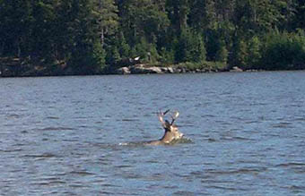
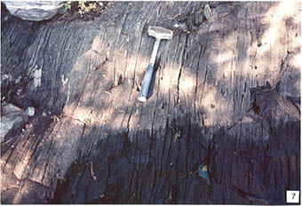
There is an old mine shaft on one of the islands. This site will be monitored periodically for any changes to integrity. Warning signs will be posted. An active quartz rock quarry exists on the south shore of Muskeg Bay on Eagle Lake. In the surrounding areas there are a number of active as well as inactive aggregate pits. Additionally, a number of tertiary and secondary roads exist leading to access points along the lake and to surrounding lakes. A lot of these were used for timber harvest at one point in time.
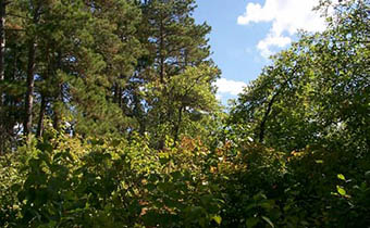
Figure 3: Deer swimming across Eagle Lake.
Historic selective logging for red and white pine, and white spruce was apparent on an un-named island south of Stanton Island. Other islands show evidence of past logging as well (i.e. logging camp remains). Harvest blocks exist to the south and southeast of Eagle Lake. These are scheduled for harvest between 2003 to 2008.
Facility infrastructure and development for recreational and/or educational purposes only may be considered in the future if there is a demonstrated demand for such facilities. All provincial policies that guide development on Crown Land are applicable in Conservation Reserves. A more detailed management plan would be required prior to any development occurring. Such a plan would have to ensure that there would be no negative impacts to any habitat or ecosystem pertinent to the values protected in this reserve.
3.3 Recreational activities
Most recreational activities that have traditionally been enjoyed in this area can continue provided they pose no threat to the natural ecosystems and features protected by the conservation reserve. Those uses that are regulated include hunting, fishing and trapping. Most other permitted activities are non-regulated (i.e. canoeing, exploring, snowmobiling). See Section 2.2.4 for the recreational uses for this Conservation Reserve as determined by the Recreation Resource Inventory.
It is recommended that sites containing man-made structures be monitored, due to the accumulation of human waste during shore lunch and camping activities.
Currently no documented trails exist in the Eagle Lake Islands Conservation Reserve. Snowmobile trails and canoe routes do run throughout Eagle Lake however.
3.4 Commercial activities
No new activities, such as commercial logging, hydroelectric power development, new transmission lines (e.g. power or communications), pipelines, highways or roads, and the extraction of minerals, aggregate or peat will be permitted.
Eagle Lake is currently licensed (2003) for commercial fishing of whitefish. Incidental species include small limits of walleye and northern pike and unlimited for several non-sport fish species. As well, a water-control structure exists on Eagle River, regulating lake levels throughout the year.
Figure 4: Inside the mineshaft looking out.
An examination of the possible impact of activities on adjacent lands should be evaluated in the Forest Management Plan.
3.5 Aboriginal interests
Eagle Lake Islands Conservation Reserve (C2340) lies within Treaty 3 area. Eagle Lake First Nations Reserve lies on the northeast shoreline of Eagle Lake. A number of historical aboriginal sites can be found on the islands (see Table 2.1). Wild rice harvesting and commercial fishing occur on Eagle Lake itself.
To date, neither this nor any other Aboriginal Group has voiced any issues in regards to this conservation reserve. Nothing in this Statement of Conservation Interest affects in any way existing or future Aboriginal or treaty rights.
3.6 Natural resources stewardship
Natural Resource Stewardship involves the consideration of the following specific natural resource management categories.
3.6.1 Vegetation management
Management within the conservation reserve will allow for the continuation of natural ecosystem processes and functions with minimal human interference.
Forest fire suppression will be carried out in accordance with the approved Fire Management Strategy for the surrounding lands. "Light on the Land" suppression techniques which do not unduly disturb the landscape will be encouraged where feasible. Examples of "light on the land" techniques may include limiting the number of trees felled or the use of heavy equipment or foam.
Opportunities for prescribed burning to achieve ecological or resource management objectives may be considered. These management objectives will be developed with public consultation prior to any prescribed burning, and reflected in the document that provides management direction for this conservation reserve. Plans for any prescribed burning will be developed in accordance with the MNR Prescribed Burn Planning Manual, and the Class Environmental Assessment for Provincial Parks and Conservation Reserves (approval pending).
Forest insect and disease management will continue as on surrounding Crown lands.
3.6.2 Fish and wildlife management
The existing Wildlife Management Unit (WMU # 8, 7B), sport fishing regulations and management activities will apply. Currently, several fish sanctuaries exist on Eagle Lake. See Appendix A for sanctuary location.
3.6.3 Landforms
None of the landforms mentioned will be altered by landform modification activities such as filling and extraction. The extraction of aggregates and similar materials are not permitted.
Mineral exploration and extraction are not permitted within the CR. Mining and related access may occur within the existing mining claim designated as Forest Reserve.
3.7 Cultural resources stewardship
To date, there have been no surveys done to assess cultural or heritage values. However, it is known and has been documented that Eagle Lake contains a number of traditional-use sites, artifact-find sites and pictographs. Further Cultural Inventories were deemed unnecessary at the time.
3.8 Client services
Given the focus on low key management, client information will be given on an inquiry basis only and will deal with the basic level of information with respect to access, natural heritage appreciation, recommended activities and boundaries.
3.9 Research
Non-destructive research by qualified individuals will be encouraged to provide a better understanding of the natural values protected by the Conservation Reserve and to advance protection, planning and management. In order to assist with enhancing the management guidelines for the reserve, the collection of additional earth and life science information during research is encouraged.
All research programs will require the approval of the Ministry of Natural Resources as will the removal of any natural or cultural specimen. The establishment of permanent plots, observation points or facilities must also be approved and be compatible with the Conservation Reserve protection objective. Any site disturbed by research activities must be rehabilitated as closely as possible to its previous state.
3.10 Marketing
Awareness of the Conservation Reserve is promoted through the Living Legacy web site. Intensive management activity to increase use is not required at this time.
4.0 Implementation
Implementation of this Statement of Conservation Interest will primarily involve monitoring activities to ensure adherence to the management guidelines and responding to inquiries about the site.
Implementation of this statement and management of the reserve are the responsibility of the Dryden Area Supervisor. Partnerships may be pursued to address management needs.
5.0 Review and revisions
5.1 Review and revisions
This Conservation Reserve Statement of Conservation Interest will be reviewed on an ongoing basis.
If changes in management direction are needed at any time, the significance of the changes will be evaluated and further consultation a possibility. Any major amendments will require full public consultation and the approval of the District Manager and Regional Director. Affected clients will be immediately informed of proposed changes to this Statement of Conservation Interest.
5.2 Public consultation
5.2.1 Results of past consultations
Consultation on the Eagle Lake Islands Conservation Reserve was conducted as part of the consultation on the Ontario’s Living Legacy Land Use Strategy, July Subsequent consultation also took place in June 2001 to refine the boundary of the Conservation Reserve.
District Manager letters, totaling 194, were sent to the Dryden Forest Management Co., Weyerhaeuser and Ontario’s Forest Industries Association Tourist Outfitters, Advisory Committees, Trappers, Land Owners, Members of the Public, NGOs and GOs. Newspaper ads were placed in the Ignace Driftwood June 20, 2001 and Dryden Observer on June 19, 2001.
First Nation Consultation letters were also sent to twelve Native communities and organizations including the Eagle Lake First Nations, Wabigoon Lake Ojibway Nation and Aboriginal People of Wabigoon. Direct consultation with Treaty 3 First Nations was carried out on a regional basis and concluded November of 2002.
No responses have been received to date from any of the above mentioned organizations/groups.
5.2.2 Present and future consultation
More widespread consultation is not deemed necessary at this time.
5.2.3 Author
This Statement of Conservation Interest was prepared by Alicia H.L. Morin, OLL Intern, Information Management, Dryden District. Assistance was provided by Martin Pell (Dryden District Planner) and members of the Dryden Area Team.
6.0 References
Blackburn, C. 2002. Earth Science Inventory – Eagle Lake Islands Conservation Reserve. Unpublished report.
Foster, R. and Harris, A. 2002. Life Science Inventory – Eagle Lake Islands Conservation Reserve. Unpublished report.
Ontario Ministry of Natural Resources. 1999. Ontario’s Living Legacy – Land Use Strategy. Queen’s Printer for Ontario.
Ontario Ministry of Natural Resources. 2002. Eagle Lake Islands Conservation Reserve (C2340) Recreation Resource Inventory Report. Unpublished report.
Ontario Ministry of Natural Resources, Lands & Natural Heritage, Lands & Waters. 1997. Conservation Reserve Policy and Procedure PL 3.03.05. 22 pp.
Appendix A: Eagle Lake Islands Conservation Reserve (C2340) Values Map
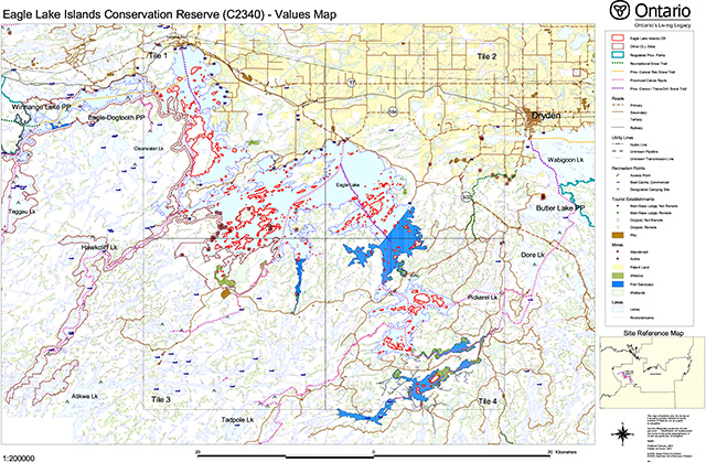
Enlarge Eagle Lake Islands Conservation Reserve (C2340) Values Map (PDF)
Eagle Lake Islands CR – Tile 1
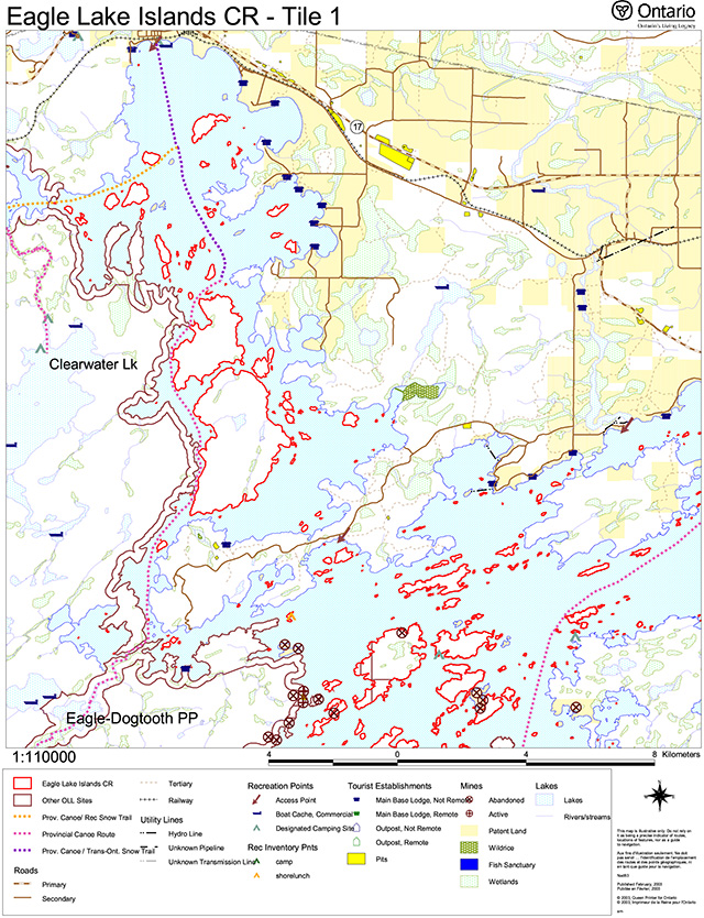
Enlarge Eagle Lake Islands CR – Tile 1 (PDF)
Eagle Lake Islands CR – Tile 2
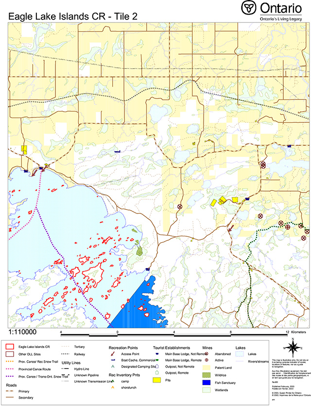
Enlarge Eagle Lake Islands CR – Tile 2 (PDF)
Eagle Lake Islands CR – Tile 3
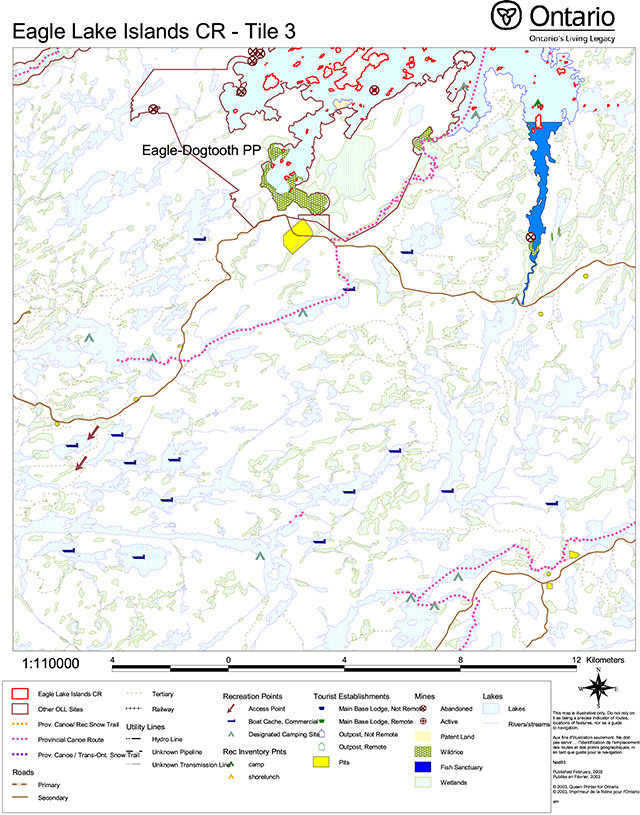
Enlarge Eagle Lake Islands CR – Tile 3 (PDF)
Eagle Lake Islands CR – Tile 4 (PDF)
Enlarge Eagle Lake Islands CR – Tile 4 (PDF)
Appendix B: Eagle Lake Islands Conservation Reserve (C2340) earth science checksheet
Detailed information for site c2340 Eagle Lake Islands
Protection history
The reserve was identified under the provincial Lands for Life - Ontario’s Living Legacy Program as containing “representative landform and vegetation types, including mixed forests on weakly broken bedrock and lacustrine deposits.” (OMNR 1999). In addition, the islands were stated to have “high recreational potential” (OMNR 1999).
No other earth science significance was assigned.
Setting
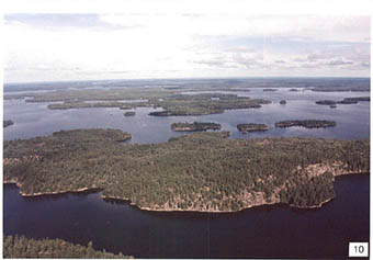
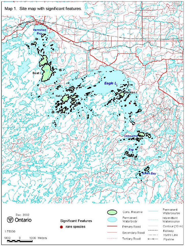
The reserve comprises 3 423 hectares, all located in Dryden MNR District. It encompasses 578 islands, spread over a 45 km distance from northwest to southeast. The islands are located in the main central part of the lake as well as in several large bays, including Vermilion and Portage bays in the northwest and Osbourne and Niven bays in the southeast. The seven largest islands (Boat, Canoe, Stanton, Net, North Twin, Float and an unnamed island in Osbourne Bay) account for 57% of the reserve area. Elevations range from 360 to 420 m a.s.l.
Earth science features
Bedrock geology
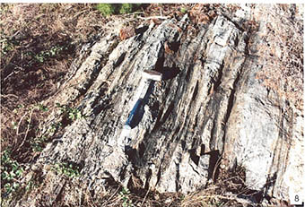
The islands of Eagle Lake straddle the west-southwest trending Wabigoon fault, a major fault internal to the Archean age Wabigoon subprovince. The islands north of the fault display metasedimentary rocks of the Warclub group, and their migmatitic and granitic equivalents: islands south of the fault provide a cross section through the Eagle Lake portion of the Eagle-Wabigoon-Manitou lakes greenstone belt (Blackburn et al. 1991: Figure 9.8) and granitic rocks that are intrusive into them.
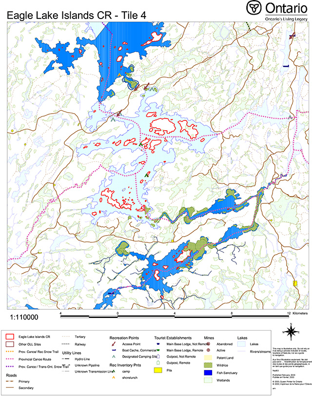
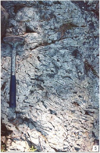
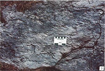
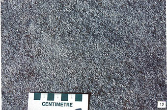
The Eagle Lake greenstone belt portion, mapped at reconnaissance scale only (Moorehouse 1941), has been divided (Blackburn et al. 1985) into three groups of volcanic rocks that are interpreted to lie one above the other in the following order: Eagle Lake volcanics; Lower Wabigoon volcanics; and Upper Wabigoon volcanics. The Eagle Lake volcanics lie south of a line between Camp 6 Bay in the west and Mukluk Bay in the east, and within the reserve, terminate in the south against granitic rocks of the Atikwa batholith at Rice Bay. They occupy much of the large peninsula between Meridian Bay and Buchan Bay, but representative rocks are seen on the islands. They are basalt flow rocks, that are commonly pillowed (e.g. station 4: photo 1). Coarsely crystalline massive flow sequences are also present (station 3: photo 2).
Lower Wabigoon volcanics occupy the centre portion of the greenstone belt, between Net Island in the west and Spring Bay in the east. The major portion is on the north end of the large peninsula that lies between Meridian Bay and Buchan Bay, but representative rocks are seen on the islands. They are a mixed sequence, predominantly of dacitic to rhyolitic composition, that may be pyroclastic (stations 2: photo 3; station 8: photo 4) or flow rocks (station 9: photo 5). Minor amounts of basaltic flow rocks are intercalated within the sequence, mostly at the east end of the unit, just to the north of Burnt and Stanton islands: at station 1, mafic breccia, formed by reaction of hot lava coming in contact with cold sea water, similar to pillow formation, was observed (photo 6).
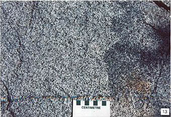
Upper Wabigoon volcanics lie north of the Lower Wabigoon volcanics, and south of the Wabigoon fault, from Smith’s Bay in the west to Reserve Bay in the east. The major portion is on Farabout Peninsula, but representative rocks can be seen on the islands. They are dominantly basalts, both massive and pillowed. Close to the Wabigoon fault the pillows are progressively flattened, a result of stress along this major fault zone that extends from Lobstick Bay of Lake of the Woods in the west-southwest to Southeast Bay of Minnitaki Lake in the east- northeast, a distance of about 150 km (OGS 1992). On an island just south of Detour Point (station 12), right against the fault, pillows that were approximately equant upon extrusion on the sea floor now have a length of up to 2 m compared to less than 10 cm in thickness (photo 7), attesting to the huge tectonic stresses imparted during movement along this fault.
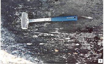
The Wabigoon fault itself, seen on the same island, is a very narrow but distinct zone (station 12). Bands of sedimentary rock of the Warclub group that lie to the north, have been intimately interlayered with pillowed volcanics of the Upper Wabigoon volcanics (photo 8) over a width of no more than 5 meters.
To the north of the Wabigoon fault, sedimentary rocks of the Warclub group have been variably metamorphosed, so that there is a complete range from low grade through to high grade, to migmatites and in the extreme case, complete melting of the sedimentary rock to form diatexite. Immediately adjacent to the fault, on the island east of station 12, the effects of deformation associated with movement on the fault can be seen (station 11: Photo 9): sandstones at low metamorphic grade contain quartz veins that have been tightly folded, suggesting that the sedimentary rocks also have been so folded. The rest of Eagle Lake to the north of this station was not visited during the present reconnaissance. Government mapping (Moorehouse 1941; Breaks et al. 1976) suggests that, as well as granitic rocks, representative examples of the metamorphic progression within Warclub sedimentary rocks can be seen on the islands of the reserve. Metasedimentary units are folded around Boat Island, and occur on a group of islands to the north of Canoe Island. Further north, in Vermilion Bay, diatexite of granitic composition occurs on, among other islands, Strawberry Island.
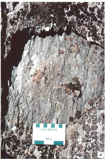
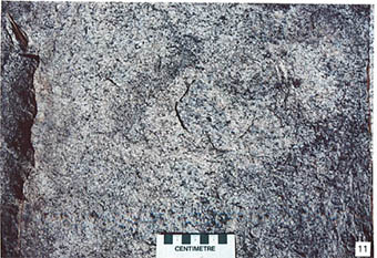
Granitic rocks of the Atikwa batholith intrude the lower part of the greenstone belt sequence, along its south side. They underlie two areas of the reserve: in the west, numerous islands that include Net, North Twin, South Twin, Prendible and Float islands; in the southeast, islands in Osbourne and Niven bays. Representative of the west area, on North Twin Island (station 10), coarse to medium grained grey tonalite forms large cliffs along its south side (photo 10). Representative of the southeast area, at Rice Bay (station 5), coarse pink biotite granodiorite occurs (photo 11), while at station 6 in Osbourne Bay, grey, medium grained biotite tonalite is present (photo 12). Rocks of the ovoid, 4 by 6 km, Froghead Bay stock are seen on a few islands in Froghead Bay (station 7). The stock is comprised of massive, coarse-grained grey biotite tonalite (photo 13).
Surficial geology
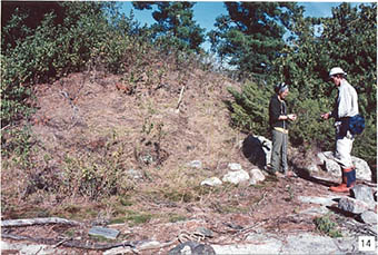
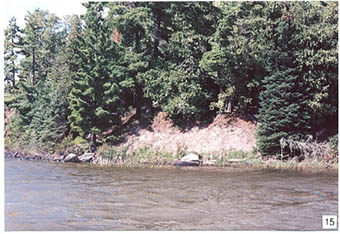
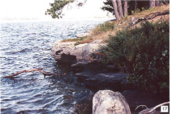
Pleistocene age surficial deposits of Eagle Lake Islands Conservation Reserve are both glacial and post-glacial. Following deposition of till, about 11 000 years ago during the Late Wisconsinan stage, widespread areas of silt and clay were deposited in glacial Lake Agassiz (Minning et al. 1994). The reserve lies immediately southwest of the Eagle-Finlayson end moraine (Roed 1980a, b: Cowan and Sharpe 1991; Minning and Sharpe 1991: Barnett et al. 1991). The northeast shore of the central part of Eagle Lake is defined in large part by the end moraine which rises well above the level of the lake behind the shore. Silty clay deposits predominate throughout central Eagle Lake, and can be observed in low eroded bluffs at lake level in numerous places (e.g. station 2: photo 14; station 7: photo 15). These deposits commonly can be seen to lie directly on bedrock (photo 14). No layering indicative of varves was seen in the clays.
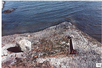
Thin till overlies bedrock on higher ground, such as numerous rocky islands (e.g. North Twin Island: photo 10) that rise well above present lake level. Direction of ice transport was from the northeast, as indicated by glacial scour features in bedrock, such as striations (station 2: photo 16). This is consistent with the major Keewatin ice movement prevalent in northwest Ontario (Zoltai 1961; Barnett 1992; Minning et al. 1994).
Recent geological processes include erosion by storm lake action of the silty clay bluffs noted above, and seasonal freeze-thaw conditions acting on joints in granitic rocks (photo 17).
Significance
The regionally extensive Wabigoon fault has other representation in P2363 Eagle-Dogtooth Provincial Park, where it underlies much of the waterway along Piskegomang Creek, to the west of the present reserve. The exposures of the fault on islands in the vicinity of Detour Point are particularly good, and augment the representation in P2363. Taken in conjunction with its presence in P2363, this earth science feature is of regional significance.
The Eagle Lake portion of the Eagle-Manitou-Wabigoon lakes greenstone belt is represented on the islands of Eagle Lake. The islands themselves give representation of a small portion of the greenstone belt rocks, perhaps less than 5%. Therefore high significance cannot be assigned to these as representative of a greenstone belt. However, the rocks of both the greenstone belt and the migmatites to the north are well exposed on the islands and relatively easily accessible by water from numerous launch sites on the lake. They are important in scientific study, and are therefore given local significance.
The glaciolacustrine deposits are well exposed and provide an excellent observational opportunity. They can be considered of regional significance.
Sensitivity
Bedrock geological features are not subject to degradation by either human activity or natural processes. Of the surface geological features, the clay deposits are subject to erosion, a natural process, but enhanced by the previous construction of a dam on the Eagle River downstream of Eagle Lake.
Recommendations
The present survey has adequately identified both bedrock and surficial features. No further recommendations for inventory are made.
References
Barnett, P.J. 1992. Quaternary Geology of Ontario; in Geology of Ontario, Ontario Geological Survey, Special Volume 4, Part 2, p. 1011-1088.
Barnett, P.J., Henry, A.P. and Babuin, D. 1991. Quaternary Geology of Ontario, west-central sheet; Ontario Geological Survey, Map 2554, scale 1:1 000 000.
Blackburn, C.E., Bond, W.D., Breaks, F.W., Davis, D.W., Edwards, G.R., Poulsen, K.H., Trowell, N.F. and Wood, J. 1985. Evolution of Archean volcanic- sedimentary sequences of the western Wabigoon Subprovince and its margins: a review; in Evolution of Archean Supracrustal Sequences, Geological Association of Canada, Special Paper 28, p 89-116.
Blackburn, C.E., Johns, G.W., Ayer, J. and Davis, D.W. 1991. Wabigoon Subprovince; in Geology of Ontario, Ontario Geological Survey, Special Volume 4, Part 1, p. 303-381.
Breaks, F.W. Bond, W.D., Westerman, C.J. and Harris, N. 1976. Operation Kenora-Ear Falls, Dryden-Vermilion Bay Sheet, District of Kenora; Ontario Geological Survey, Map P.1203, scale 1:63 360.
Cowan, W.R. and Sharpe, D.R. 1991. Surficial Geology, Wabigoon Lake, Ontario; Geological Survey of Canada, Map 1774A, scale 1:100 000.
Minning, G.V. and Sharpe, D.R. 1991. Surficial geology, Blue Lake, Ontario- United States; Geological Survey of Canada, Map 1772A, scale 1:100 000.
Minning, G.V., Cowan, W.R., Sharpe, D.R. and Warman, T.A. 1994. Quaternary geology and drift composition, Lake of the Woods region, northwestern Ontario; Geological Survey of Canada, Memoir 436, 239 p.
Moorhouse, W.W. 1941. Eagle Lake area; Ontario Geological Survey, Map 48d, Scale 1:63 360.
OGS 1992. Tectonic Assemblages of Ontario, west-central sheet; Ontario Geological Survey, Map 2576, scale 1:1 000 000.
OMNR 1999. Ontario’s Living Legacy: Land Use Strategy; Ontario Ministry of Natural Resources, 136 p., accompanied by map, scale 1:1 200 000.
Roed, M.A. 1980. Northern Ontario Engineering Geology Terrain Study, Data Base Map, Blue Lake; Ontario Geological Survey, Map 5058, scale 1:100 000.
Roed, M.A. 1980. Northern Ontario Engineering Geology Terrain Study, Data Base Map, Wabigoon Lake; Ontario Geological Survey, Map 5059, scale 1:100 000.
Zoltai, S.C. 1961. Glacial history of part of northwestern Ontario; Geological Association of Canada, Proceedings, v. 13, p. 61-83.
Photographs
-
Pillow lavas of the Eagle Lake volcanics, Lone Pine Well- preserved pillows are at the top of the photo, while hammer lies on sheared rocks. (Stn. 4; UTM 0495496E 5501161N)
-
Massive, coarse grained mafic volcanics, of the Eagle Lake volcanics. (Stn. 3; UTM 0496508E 5502006N)
-
Intermediate lapilli-tuff of the Lower Wabigoon Small island south of Burnt Island, Eagle Lake. (Stn. 2; UTM 0493267E 5503532N)
-
Intermediate lapilli-tuff of the Lower Wabigoon Island at north end of Fornieri Bay. (Stn. 8; UTM 0485195E 5503851N)
-
Dacitic to rhyolitic flow rock of the Lower Wabigoon Note fracture pattern typical of felsic flow units. Island between Fornieri Bay and South Twin Island. (Stn. 9; UTM 0483949E 5502902N)
-
Mafic aquagene breccia of the Lower Wabigoon volcanics. Island northwest of Burnt (Stn. 1; UTM 0492529E 5504754N)
-
Pillow lavas of the Upper Wabigoon volcanics that have been deformed (flattened) in proximity to the Wabigoon Island near Detour Point. (Stn. 12; UTM 0472692E 5503606N)
-
Interlayered sedimentary and volcanic rocks in the Wabigoon fault Softer mafic volcanic layers weather down in contrast to more siliceous sedimentary layers. Island near Detour Point. (Stn. 12; UTM 0472692E 5503606N)
-
Metasedimentary sandstones of the Warclub group. Presence of tightly folded white quartz veins aligned parallel to the schistosity suggests the sandstones have been similarly folded. (Stn. 11; UTM 0472730E 5503707N)
-
View to the north over Eagle Lake from above South Twin Island. North Twin Island is in the foreground, with Schroeder Island immediately to the north. Temple Bay is in the upper right, and Nash’s (or Garnet) Bay to the far left.
-
Coarse, pink biotite granodiorite of the Atikwa batholith, Rice Bay. (Stn. 5; UTM 0496919E 5497389N)
-
Medium grained, grey, biotite tonalite of the Atikwa batholith, Osborne Bay. (Stn. 6; UTM 0497975E 5492387N)
-
Massive grey biotite tonalite of the Froghead Bay stock, Froghead Photo illustrates contrast between darker fresh surface and lighter weathered surface. (Stn. 7; UTM 0493146E 5498563N)
-
Eroded bank of silty clay, overlying bedrock. Small island southwest of Stanton (Stn. 2; UTM 0493267E 5503532N)
-
Silty clay bank on island in Froghead Bay. (Stn. 7; UTM 0493146E 5498563N)
-
Glacial striations on small island south of Burnt Island. View is up-ice, toward the northeast. (Stn. 2; UTM 0493267E 5503532N)
-
Seasonal frost heaving in shallow dipping jointing in tonalite, Osborne Bay. (Stn. 6; UTM 0497975E 5492387N)
Additional station
Stn. 10 UTM 0482291E 5503438N
Earth science inventory checklist
| Name | Eagle Lake Islands |
|---|---|
| OLL ID | C2340 |
| Map name | Lawrence Lake, W |
| NTS Number | 52F/06,10,11,14 |
| UTM reference | Z15 490000E 550 |
| OBM Number | |
| Latitude | 49° 42' N |
| Longitude | 93° 15' W |
| Elevation – max | 420 m |
| Elevation – min | 360 m |
| County | District of Kenora |
| Township | unorganized |
| Lot | NA |
| Concession | NA |
| Area (ha) | 3,422.00 |
| Ownership | Crown |
| Year - Roll - flight line – number | not made available |
| MNR region | Northwest |
| MNR District | Dryden |
| Park zone | Northwest |
Location map

Earth science features
Archean age, Wabigoon Subprovince: Eagle Lake and its islands straddle a major Archean fault boundary: the east trending Wabigoon fault. South of the fault are metavolcanic rocks (mafic and felsic) of the Eagle- Wabigoon lakes greenstone belt. South of the greenstone belt, islands in Osbourne Bay are underlain by granitic rocks of the Atikwa batholith. North of the fault are granites and migmatites of the Winnipeg River subprovince.
Quaternary: much of Eagle Lake is underlain by Pleistocene glaciolacustrine clays, with shallow ground moraine over bedrock at higher elevations.
Significance
Exposures of the regionally extensive Wabigoon fault on islands near Detour Point are good, and augment representation in P2363, Eagle-Dogtooth Provincial Park. They are given regional significance. The islands on Eagle Lake give representation of only a small part of the Eagle Lake portion of the Eagle- Manitou-Wabigoon greenstone belt. However, their easy access makes them important in scientific study, and they are given local significance.
Sensitivity
Bedrock features are not sensitive to natural or cultural impacts. Clay deposits are subject to erosion, enhanced by the raising of water levels by construction of a dam on the Eagle River.
Recommendations
No recommendations are made.
Major references
Blackburn et al. 1991, “Wabigoon Subrovince” in OGS Special Volume 4; Breaks et al. 1976, OGS Map P.1203; Cowan and Sharpe 1991, GSC Map 1774A; Minning and Sharpe 1991, ,GSC Map 1772A; Moorehouse 1941, OGS Map 48d; Roed 1980, OGS Maps 5058 and 5059.
Date compiled
February 15, 2003
Compiler
C.E. Blackburn, Blackburn Geological Services
Ontario Ministry of Natural Resources, Ontario Parks
300 Water Street, Peterborough, Ontario K9J 8N1
Appendix C: Eagle Lake Islands Conservation Reserve (C2340) life science checksheet
C2340 Eagle Lake Islands
Natural heritage area – life science checksheet
| Name | Eagle Lake Islands |
|---|---|
| Map Name | Lawrence Lake, Wabigoon, Osbourne Bay, Vermilion Bay |
| Map Number | 52F6, 52F10, 52F11, 52F14 |
| UTM Ref. | Zone 15 490000 \ 5504000 N |
| Lat. | 49 42' N |
| Long. | 93 15 ' W |
| NAD | 83 |
| Min. Alt. | 360 m |
| Max. Alt. | 420 m |
| County | Kenora |
| Locality | 20 km SW of Dryden |
| Township | Unorganized |
| Area | 3422 ha |
| Ownership | Crown |
| MNR Region | Northwest |
| Ecoregion and Ecodistrict | 4S-4, 4S-5 |
| Landform Unit | See Table 4 |
| MNR District | Dryden |
| Aerial Photographs | Year-Roll-Flight Line-Numbers 11 flight lines |
Location map
Physical and biological features
C2340 includes 578 Islands on Eagle Lake, spread out over 45 km (Map 1). The reserve does not encompass the waters of Eagle Lake, but does include two small lakes (total area of 16 ha) on Boat Island. Eagle Lake is a large (>27000 h) irregularly shaped lake with several large bays, including Vermilion and Portage bays in the northwest, and Osbourne and Niven bays in the southeast. Although the overall MEI is 3.9, there is considerable variation among basins, ranging from oligotrophic in the deeper western arm to eutrophic in the southern bays. The islands of C2340 range in size from <1 ha to 864 ha (Table 1) and have 370 km of shoreline. Although exposed rocks and small islets are most numerous, the seven largest islands (Boat, Canoe, Stanton, Net, North Twin, Float, and an unnamed island in Osbourne Bay) account for 57% of the reserve area.
| Size (ha) | # of Islands | Total Area (ha) |
|---|---|---|
| <1 | 398 | 105 |
| 1-10 | 143 | 436 |
| 10-100 | 31 | 917 |
| 100-1000 | 7 | 1965 |
| total | 579 | 3422 |
Glaciolacustrine sediments predominate in much of the reserve, with silty clay soils common. Weakly broken bedrock with a thin veneer of clayey soil, or silty tills on higher ground, occurs most Boat and Canoe islands, as well some of the smaller adjacent islands. There are also smaller areas of weakly to strongly broken bedrock on Net and North Twin islands, but too small scale to be picked up by original analysis. Weakly broken ground moraine is found on the islands of Niven Bay at the south end of the reserve.
The forests of Eagle Lake Islands are a mixture of boreal and Great Lakes St. Lawrence elements, and are predominately pure or mixed conifer forests (Table 2). Forests dominated by balsam fir comprise approximately 1/3 of the forests, and balsam fir is present throughout much of the reserve as a subdominant or understorey species as well. Many of these are conifer mixedwoods (Ecosite 27, with balsam fir, jack pine, and trembling aspen and minor components of white birch, black and white spruce. The mesic, silty, or clayey soils typically support a rich shrub and herbaceous layer, with raspberry, buffaloberry bluebead lily, clubmosses, sweet coltsfoot, large-leaved aster, and bracken fern. Trembling aspen and white birch are subdominants, but there are some aspen-dominated stands on Canoe and Boat islands and some birch stands in the Stanton Island area.
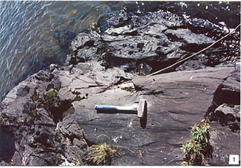
Pure and mixed jack pine forests are abundant in the central and western part of the reserve, particularly on the coarser soils of Float, Boat, Canoe, and Net islands (Photo 1). Pipsissewa, Bebb’s willow, green alder and Schreber’s moss are common understorey species on well-drained sites (e.g. Ecosite 15), with bunchberry, Canada mayflower, starflower abundant on more mesic sites (e.g. Ecosite 20). Black spruce and white birch are common associates in these stands.
Pure red pine stands (V26, ES24) are found on North and South Twin islands, and mixedwood (V13) stands with at least 10% red pine are also concentrated in the centre of the reserve. Small stands and individual red pine are scattered throughout the reserve e.g., Stanton Island, islands on Osbourne & Vermilion bays. White pines are found scattered throughout the reserve as a minor overstorey component (typically 10% or less cover). Only one small stand (6 ha), on North Twin Island, is white pine dominated (Pw7Pr3), and is approximately 105 years old. These pine communities occur on well- drained tills and clays, and commonly have serviceberries, chokecherry, raspberry in the understorey.
Cedar is a component in scattered stands within the reserve, particularly in Osbourne Bay where it is the dominant species on a few islands. Cedar and black spruce are typically more common on north sides of islands with pine and birch more abundant on south-facing shores.
Large areas (~100 ha) of sparse forests of jack pine on very shallow soil (e.g., ES12) and rock barren (vegetated bedrock LV) are found on Canoe and Boat islands (Photo 2). There are ~6 ha of rock barren (ES7) and cliff (ES4) are found on the south shore of Net and North Twin islands as well. Cliff and barren communities are dominated by fragile cliff fern, harebell, pale corydalis, poverty grass, bristly sarsaparilla, Cladina lichens, ground and common juniper, meadowsweet, and smooth sumac.
There are approximately 100 ha of wetlands in the reserve, primarily on Boat, Canoe, Net, and two unnamed islands in Osbourne Bay. Most of this is poorly treed to open peatlands, mainly poor conifer swamp (ES35) and poor fens (ES40, 41)(Photo 3). These are often fringed by thicket swamp (ES44) with speckled alder and lake sedge, grading into tall shrub shore fen (W16) with bog birch, sweet gale, leatherleaf, wire sedge, marsh cinquefoil (Photo 4). There is a small black ash stand on north end of Boat Island. Marshes are small, scattered and poorly represented since the reserve goes only to the mean high water mark.
Representation
Table 4 summarizes representation of landform vegetation types of the Eagle Lake Islands Conservation Reserve for Ecodistricts 4S-4 and 4S-5 as recently refined by Ontario Parks (Steve Kingston pers. comm.). An older version of the landform vegetation representation matrix based on the original Ontario Living Legacy gap analysis is included for comparison (Table 5).
Eagle Lake Islands (3422 ha) contributes far more to Ecodistrict 4S-4 and 4S-5 representation than the 1646 ha indicated in the revised analysis (Table 4) or the 472 ha of the original OLL analysis (Table 5). The discrepancy is from unclassified reserve land due to the coarse scale of the provincial geology data used in the revised analysis. There is significantly more bedrock and lacustrine deposits than previously indicated, and there is a also small area of weakly broken ground moraine in the reserve. Many areas of the bedrock landform LV-types often have a thin veneer of till, although some areas have exposed bedrock with no or very shallow soils (especially Boat and Canoe islands). There is considerably more representation of most vegetation types on bedrock and glaciolacustrine deposits, particularly conifer, mixed, and sparse forests. Representation of these LV-types is considered provincially significant.
The forested LV-types on organic deposits on East Long Island in Ecodistrict 4S-4 were misclassified and are actually on lacustrine deposits. Elsewhere in the reserve however, there are approximately 24 ha (10 ha in 4S-4 and 14 ha in 4S-5) of thicket swamp that classify as sparse deciduous forests on organic deposits. According to the FRI, there are also ~80 ha of treed muskeg (typically conifer swamp, treed fen, or treed bog) and 6 ha of open muskeg, (typically open fen or bog in the conservation reserve). These treed and open wetland types on organic deposits were not previously recorded for the reserve in the LV analysis. They were misclassified as various upland LV-types.
Although there are over 100 ha of burn on Canoe and Boat islands according to the original LV analysis, recent satellite imagery and fire mapping from the 1920s to present do not indicate any fires occurring in the reserve.
Condition
The reserve is in relatively good condition given its relatively easy access and history of human use. There are numerous access points with boat launches providing access to Eagle Lake and the islands of the reserve, notably Vermilion Bay, Eagle River, and Bear Narrows. The reserves are also along the travel corridor to the adjacent Eagle-Dogtooth Provincial Park.
The islands of the reserve have been impacted by past logging activities, particularly for red and white pine, and white spruce. The timing and extent of post logging is unknown. These tree species may have formerly been more abundant on the islands, prior to selective logging and fire suppression. An unnamed island south of Stanton Island was formerly logged, and is now dominated by a shrub community of Canada yew, beaked hazel, chokecherry, and mountain maple. It appears to be maintained in this state by browsing. Remains of logging camps e.g. garbage tips, are found on some islands e.g., North Twin Island.
Eagle Lake is heavily used for recreation, particularly angling. Its supports a wide variety of sport fish, notably walleye, northern pike, muskellunge, sauger, lake trout, and lake whitefish. Islands of the reserve are used for shore lunches and picnicking. There are several commercial outposts, and numerous private camps on the mainland shoreline adjacent to the reserve, as well as several camps on privately owned islands. There are a few buildings on Float Island within the reserve. There is also a designated campsite on North Twin Island, two small islands on Muskeg Bay, and one on small, unnamed island on Niven Bay.
There are seven baitfish blocks, 11 bear management areas, and 10 trap lines overlapping the reserve.
Diversity
On the landform-vegetation type scale, the Eagle Lake Islands Conservation Reserve has low to moderate diversity, being predominately glaciolacustrine or bedrock with thin tills. A total of 15 LV types are represented in the reserve. Boreal, Great Lakes – St. Lawrence, and prairie elements add to the vegetation diversity, and there is a good diversity of island sizes. The wetlands and waters of Eagle Lake also contribute to the effective diversity of habitats in the reserve. In particular, the wetlands in Eldorado and Muskeg bays provide significant wildlife and fish habitat (Noble 1995).
Ecological considerations
The reserve is sensitive to edge effects and outside influence given the extensive shoreline, large area over which the reserve islands are scattered, the private lands on islands and activities on the adjacent mainland, and high recreational use in the area. Spruce budworm outbreaks occurred in the reserve during the late 1980s and early 1990s, resulting in defoliation and mortality of white spruce and balsam fir. The Lake of the Woods Control Board regulates water levels on Eagle Lake. Water level regulation has little direct impact on the reserve since its boundaries do not encompass the lake.
The islands of the reserve are somewhat buffered from the effects of fire by the barrier posed by Eagle Lake. Large-even aged stands of jack pine on Canoe and Boat islands are likely fire origin circa 1908.
Special features
Provincially rare (S1) cut-leaved ragwort (Senecio eremophilus) was found on a south-facing clay bank on an unnamed island south of Stanton Island. The site has been highly disturbed by past logging and it was found in association with fringed bindweed, pale corydalis, and common hemp nettle. The only other known native occurrences of cut-leaved ragwort in Ontario are from Kakagi Lake near Sioux Narrows, and a few remnant prairies associated with cliffs south of Thunder Bay.
Red and white pine on Eagle Lake are near the edge of their continuous range in Ontario. Although, no red and white pine stands in the reserve are old growth, individual trees may exceed 120 years of age. White pine up to 80 cm DBH were observed in the field (Photo 5).
Relict prairie communities are found in at least three locations on south-facing shores with well-drained fine-textured soils. The open overstorey consists of several to 20 bur oak, with red pine, white pine, and/or white spruce in association. The oaks are 10 to 40 cm DBH, up to 8 m tall, and approximately 50 to 120 years of age (Photo 6). There is often a dense shrub layer of hawthorn, downy arrowwood, snowberry and bearberry, as well as abundant graminoids. Rough cinquefoil, a western species, was also present. Although not high quality prairies in terms of size, species diversity, or provincially rare species, they are significant since they are rare in Ecodistrict 4S4.
Bald eagles are known to nest at numerous locations in the reserve, including a new nest with two juveniles found on unnamed island south of Stanton Island during fieldwork.
American white pelicans, considered Endangered in Ontario, have been observed foraging on the lake but are not known to nest there.
Several bays of Eagle Lake that encompass reserve islands are fish sanctuaries in the spring.
Recommendations
Approximately 10 ha of non-insular wetland in Rice Bay are included in the reserve. These wetlands are wild rice marshes and shore fens (W14, W15) that grade into conifer swamp on the mainland. The mapped boundaries of the conservation reserve should be modified, unless the intent is include these areas that are not actually islands.
Significance level and summary of major representative values
Eagle Islands Conservation Reserve provides provincially significant representation for conifer, mixed, and sparse forests on lacustrine sediments and bedrock in Ecodistrict 4S-4, and to a lesser extent, 4S-5. The reserve has regionally significant prairie elements, provincially rare plants, and red and white pine stands.
Major information sources
Bakowsky, W.D. and M.J. Oldham. 1998. Significant prairie and savannah vegetation in northwestern Ontario. Natural Heritage Information Centre, Ont. Min. Natur. Resour., Peterborough. Unpublished report.
Harris, A.G., S.C.McMurray, P.W.C.Uhlig, J.K.Jeglum, R.F.Foster and G.D. Racey. 1996. Field guide to the wetland ecosystem classification for northwestern Ontario. Ont. Min. Natur. Resour., Northwest Sci. & Technol. Thunder Bay, Ont. Field Guide FG-01. 74 pp. + Append.
Noble, T. 1995. Site District 4S4 gap analysis. Unpublished report for Northwest Region, Ont. Min. Natur. Resour., Thunder Bay, Ont. 22 p. + Append.
OMNR. 1999. Ontario’s Living Legacy – Land Use Strategy. Queen’s Printer, Toronto.
Racey, G.D., A.G. Harris, J.K.Jeglum, R.F.Foster and G.M.Wickware. 1996. Terrestrial and wetland ecosites of northwestern Ontario. Ont. Min. Natur. Resour., Northwest Sci. & Technol. Thunder Bay, Ont. Field Guide FG-02. 88 pp. + Append.
Sims, R.A., W.D. Towill, K.A. Baldwin, P. Uhlig and G.M. Wickware. 1997. Field guide to the forested ecosystem classification for northwestern Ontario. Ont. Min. Natur. Resour., Northwest Sci. & Technol. Thunder Bay, Ont. Field Guide FG-03. 176 p.
Date Compiled: 21/05/03
Compiler(s): Robert Foster, Allan Harris Northern Bioscience
Map 1. Site map with significant features
Enlarge map 1. Site map with significant features (PDF).
Photo 1. Jack pine dominated forests occur on shallow soils over bedrock.
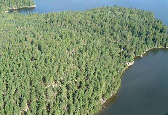
Photo 2. Cliffs along south side of North Twin Island
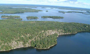
Photo 3. Treed and open peatlands are found along shorelines on some islands.
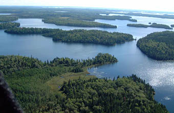
Photo 4. Shore fen at Rice Bay.
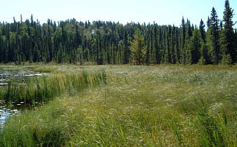
Photo 5. White pine on rocky shorelines are found in the central part of the reserve.
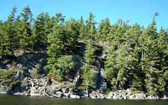
Photo 6. Prairie community with bur oak and dense shrub understorey.
| WG Code | Working Group | Area (ha) | % Forest |
|---|---|---|---|
| 1 | White Pine | 6 | 0.2 |
| 4 | Red Pine | 130 | 4.8 |
| 7 | Jack Pine | 753 | 27.8 |
| 11 | Black Spruce | 252 | 9.3 |
| 12 | White Spruce | 8 | 0.3 |
| 13 | Balsam Fir | 910 | 33.6 |
| 18 | Larch | 2 | 0.1 |
| 19 | Other Conifer | 66 | 2.4 |
| 29 | Other Hardwood | 3 | 0.1 |
| 33 | Poplar | 437 | 16.1 |
| 36 | White Birch | 139 | 5.1 |
| Total | 2706 | 100.0 |
* approximately 80% of C2340 has FRI data available
| Plot No. | V/W Type | ES Type | Date |
|---|---|---|---|
| 415 416 417 418 419 420 420 | V21 V26 V3.3 V26 V20 V15 W22 | ES27 ES24 ES10 ES24 ES25 ES27 ES40 | 12/9/2002 12/9/2002 12/9/2002 12/9/2002 12/9/2002 12/9/2002 12/9/2002 |
Table 4. Landform – vegetation (LV) type representation for Eagle Lake Islands Conservation Reserve for Ecodistrict 4S-4 and 4S-5. (derived from analysis by Ontario Parks; Steve Kingston pers. comm.).
Ecodistrict 4S-4
| LV Description | Ecodistrict: Area (ha) | Ecodistrict: Representation Target % | Ecodistrict: Representation Target ha | Ecodistrict: Representation Target Protected Areas (ha) | Eagle Lake: Area (ha) | Eagle Lake: Contribution to Ecodistrict Target (%) | Eagle Lake: Contribution to Existing Protection (%) | Eagle Lake: Confirmed in Field |
|---|---|---|---|---|---|---|---|---|
| Glaciolacustrine deposits-Dense Deciduous Forest | 31,723 | 12 | 3,807 | 1,210 | 3 | 0 | 0 | X |
| Glaciolacustrine deposits-Mixed Forest – mainly Coniferous | 31,445 | 12 | 3,773 | 1,431 | 36 | 1 | 3 | X |
| Bedrock-Mixed Forest – mainly Coniferous | 20,385 | 12 | 2,446 | 1,448 | 349 | 14 | 24 | X |
| Glaciolacustrine deposits-Dense Coniferous Forest | 19,316 | 12 | 2,318 | 1,865 | 56 | 2 | 3 | X |
| Glaciolacustrine deposits-Sparse Coniferous Forest | 16,829 | 12 | 2,019 | 1,110 | 10 | 0 | 1 | X |
| Glaciolacustrine deposits-Mixed Forest – mainly Deciduous | 13,003 | 12 | 1,560 | 421 | 14 | 1 | 3 | X |
| Bedrock-Dense Coniferous Forest | 12,690 | 12 | 1,523 | 845 | 51 | 3 | 6 | X |
| Bedrock-Sparse Coniferous Forest | 12,388 | 12 | 1,487 | 1,288 | 195 | 13 | 15 | X |
| Bedrock-Dense Deciduous Forest | 8,680 | 12 | 1,042 | 607 | 61 | 6 | 10 | X |
| Bedrock-Mixed Forest – mainly Deciduous | 7,633 | 12 | 916 | 487 | 103 | 11 | 21 | X |
| Organic deposits-Mixed Forest – mainly Coniferous | 3,250 | 12 | 390 | 278 | 3 | 1 | 1 | |
| Organic deposits-Dense Deciduous Forest | 2,544 | 12 | 306 | 114 | 2 | 1 | 1 | |
| Bedrock-Sparse Deciduous Forest | 2,366 | 12 | 285 | 124 | 26 | 9 | 21 | X |
| Organic deposits-Sparse Coniferous Forest | 1,996 | 12 | 243 | 228 | 3 | 1 | 1 | X |
| Organic deposits-Mixed Forest – mainly Deciduous | 1,101 | 15 | 161 | 158 | 7 | 4 | 4 |
Ecodistrict 4S-5
| LV Description | Ecodistrict: Area (ha) | Ecodistrict: Representation Target % | Ecodistrict: Representation Target ha | Ecodistrict: Representation Target Protected Areas (ha) | Eagle Lake: Area (ha) | Eagle Lake: Contribution to Ecodistrict Target (%) | Eagle Lake: Contribution to Existing Protection (%) | Eagle Lake: Confirmed in Field |
|---|---|---|---|---|---|---|---|---|
| Bedrock-Mixed Forest – mainly Coniferous | 237,440 | 12 | 28,493 | 18,258 | 124 | 0 | 1 | X |
| Bedrock-Dense Coniferous Forest | 145,337 | 12 | 17,440 | 9,212 | 90 | 1 | 1 | X |
| Bedrock-Sparse Coniferous Forest | 123,461 | 12 | 14,815 | 10,279 | 334 | 2 | 3 | X |
| Bedrock-Dense Deciduous Forest | 81,951 | 12 | 9,834 | 5,010 | 38 | 0 | 1 | X |
| Bedrock-Sparse Deciduous Forest | 44,792 | 12 | 5,375 | 1,662 | 3 | 0 | 0 | X |
| Bedrock-Mixed Forest – mainly Deciduous | 40,181 | 12 | 4,822 | 3,229 | 55 | 1 | 2 | X |
| Glaciolacustrine deposits-Mixed Forest – mainly Coniferous | 10,659 | 12 | 1,279 | 521 | 16 | 1 | 3 | X |
| Glaciolacustrine deposits-Dense Coniferous Forest | 6,818 | 12 | 822 | 208 | 24 | 3 | 12 | X |
| Glaciolacustrine deposits-Sparse Coniferous Forest | 3,581 | 14 | 492 | 84 | 35 | 7 | 42 | X |
| Glaciolacustrine deposits-Mixed Forest – mainly Deciduous | 1,156 | 37 | 426 | 33 | 9 | 2 | 28 | X |
Table 5. Original version of landform – vegetation (LV) type representation for Eagle Lake Islands Conservation Reserve used in Ontario Living Legacy gap analysis.
| Site District | Landform | Surface Expression | burn | conifer | conifer mixed | deciduous | deciduous mixed | sparse forest | vegetated bedrock | Grand Total |
|---|---|---|---|---|---|---|---|---|---|---|
| 4S-4 | Bedrock | Weakly Broken | 5R | 10 | 19R | 1R | 70 | 4R | 109 | |
| 4S-4 | Lacustrine Deposit | 62 | 42R | 49 | 31 | 9R | 170C | 363 | ||
| Grand Total | 67 | 52 | 68 | 31 | 10 | 240 | 4 | 472 |
Ccritical to meet representation targets at the Site District level
Rcontributes to representation of the LV type at the Site District level
| Arid | Very Dry | Dry | Dry Mesic | Mesic | Wet Mesic | Wet | Very Wet | Saturated | Open Water | |
|---|---|---|---|---|---|---|---|---|---|---|
| Colder: Rock | ES12 | ES12 | ||||||||
| Colder: Sand | ||||||||||
| Colder: Loam | ES17 | |||||||||
| Colder: Clay | ||||||||||
| Colder: Organic | ES40,ES41 | ES41 | ||||||||
| Normal: Rock | ES4, ES7 | ES12 | ES12 | ES17 | ||||||
| Normal: Sand | ||||||||||
| Normal: Loam | ES27, ES29 | ES27, ES29 | ||||||||
| Normal: Clay | ES28, ES29 | ES38 | ||||||||
| Normal: Organic | ES35 ES36 | ES45 | ES48 | |||||||
| Warmer: Rock | ES4, ES7 | ES11, ES12 | ES11, ES12 | |||||||
| Warmer: Sand | ||||||||||
| Warmer: Loam | ES10 | ES10 | ES24 | ES24 | ||||||
| Warmer: Clay | ES10 | ES24 | ||||||||
| Warmer: Organic |
Eagle Lake Islands Conservation Reserve species lists
The following species lists are based fieldwork conducted September 12, 2002 and data provided by OMNR.
Plant list
Taxonomic order and species names generally follow Morton and Venn (1990). Introduced species are marked “I”. Provincially rare species (Oldham 1999) are marked “P”. Regionally rare species (TBFN 1998) are marked "R". Voucher specimens were collected for species marked “*”.
| Family Equisetaceae | Horsetail Family |
|---|---|
| Equisetum sylvaticum L. | Woodland Horsetail |
| Family Dennstaetiaceae | Bracken Family |
|---|---|
| Pteridium aquilinum (L.) Kuhn | Bracken |
| Family Dryopteridaceae | True Fern Family |
|---|---|
| Dryopteris carthusiana (Villars) H.P.Fuchs | Spinulose Wood Fern |
| Dryopteris fragrans (L.) Schott | Fragrant Cliff Fern |
| Gymnocarpium dryopteris (L.) Newman | Oak Fern |
| Woodsia ilvensis (L.) R.Br. | Rusty Woodsia |
| Family Lycopodiaceae | Clubmoss Family |
|---|---|
| Lycopodium annotinum L. | Bristly Clubmoss |
| Lycopodium clavatum L. | Common Clubmoss |
| Family Cupressaceae | Juniper Family |
|---|---|
| Juniperus horizontalis Moench | Creeping Juniper |
| Thuja occidentalis L. | Eastern White Cedar |
| Family Pinaceae | Pine Family |
|---|---|
| Abies balsamea (L.) Miller | Balsam Fir |
| Larixlaricina (Duroi) K.Koch | Tamarack |
| Pinus banksiana Lambert | Jack Pine |
| Pinus strobus L. | White Pine |
| Family Taxaceae | Yew Family |
|---|---|
| Taxus canadensis Marshall | Canada Yew |
| Family Alismataceae | Water Plantain Family |
|---|---|
| Sagittaria rigida Pursh | Stiff Arrowhead |
| Family Araceae | Arum Family |
|---|---|
| Acorus americanus L. | Sweet Flag |
| Family Cyperaceae | Sedge Family |
|---|---|
| Carex aquatilis Wahlenb . | Water Sedge |
| Carex disperma Dewey | Two-seeded Sedge |
| Carex lacustris Willd. | Lake Sedge |
| Carex lasiocarpa Ehrh. | Wire Sedge |
| Carex trisperma Dewey | Three-fruited Sedge |
| Eleocharis smallii Britton | Marsh Spikerush |
| Scirpuscyperinus (L.) Kunth | Black-sheathed Bulrush |
| Family Juncaceae | Rush Family |
|---|---|
| Juncus tenuis Willd. | Slender, Path Rush |
| Luzula acuminata Raf. | Hairy Wood Rush |
| Family Lemnaceae | Duckweed Family |
|---|---|
| Lemna minor L. | Lesser Duckweed |
| Family Liliaceae | Lily Family |
|---|---|
| Clintonia borealis (Aiton) Raf. | Blue Bead Lily |
| Maianthemum canadense Desf. | Wild Lily-of-the-valley |
| Family Poaceae | Grass Family |
|---|---|
| Agrostis scabra Willd. | Ticklegrass |
| Calamagrostis canadensis (Michaux ) P.Beauv. | Bluejoint Grass |
| Danthonia spicata (L.) P.Beauv. ex Roemer & Schultes | Poverty Grass |
| Deschampsia flexuosa (L.) Trin. | Wavy Hair Grass |
| Muhlenbergia mexicana (L.) Trin. | Mexican Muhly |
| Poa palustris L. | Fowl Blue Grass |
| I * Poa pratensis L. | Kentucky Blue Grass |
| Family Scheuchzeriaceae | Pod-Grass Family |
|---|---|
| Scheuchzeria palustris L. | Pod-grass |
| Family Typhaceae | Cattail Family |
|---|---|
| Typha latifolia L. | Common Cattail |
| Family Aceraceae | Maple Family |
|---|---|
| Acer spicatum Lam. | Mountain Maple |
| Family Anacardiaceae | Sumac Family |
|---|---|
| Rhus glabra L. | Smooth Sumac |
| Family Apiaceae | Parsley Family |
|---|---|
| Cicuta maculata L. | Spotted Cowbane |
| Sium suave | Walter Water Parsnip |
| Family Apiaceae | Parsley Family |
|---|---|
| Cicuta maculata L. | Spotted Cowbane |
| Sium suave Walter | Water Parsnip |
| Family Apocynaceae | Dogbane Family |
|---|---|
| Apocynum androsaemifolium L. | Spreading Dog Bane |
| Family Araliaceae | Ginseng Family |
|---|---|
| Aralia hispida Vent. | Bristly Sarsaparilla |
| Aralia nudicaulis L. | Wild Sarsaparilla |
| Family Asteraceae | Sunflower Family |
|---|---|
| Anaphalis margaritacea (L.) Benth. & Hook. f.ex C.B. | Pearly Everlasting Clarke |
| Aster lanceolatus Willd. | Panicled Western Aster |
| Aster macrophyllus L. | Large-leaved Aster |
| Bidens frondosa L. | Bur Marigold |
| Cirsium muticum Michaux | Swamp Thistle |
| I Cirsium vulgare (Savi ) Ten. | Bull Thistle |
| Conyza canadensis (L.) Cronq. | Horseweed |
| Eupatorium perfoliatum L. | Boneset |
| Euthamia graminifolia (L.) Nutt. | Grass-leaved Goldenrod |
| Hieracium canadense Michaux | Canada Hawkweed |
| Petasites frigidus (L.) Fries | Sweet Coltsfoot |
| P*Senecio eremophilus Richards | Cut-leaved Ragwort |
| * Solidago nemoralis Aiton | Wood Goldenrod |
| I Taraxacum officinale G. Weber | Common Dandelion |
| Family Balsaminaceae | Touch-me-not Family |
|---|---|
| Impatiens capensis Meerb. | Jewel Weed |
| Family Betulaceae | Birch Family |
|---|---|
| Alnus incana (L.) Moench | Speckled Alder |
| Alnus viridis (Chaix) DC. | Green Alder |
| Betula papyrifera Marshall | White Birch |
| Betula pumila L. | Dwarf Birch |
| Corylus cornuta Marshall | Beaked Hazelnut |
| Family Brassicaceae | Mustard Family |
|---|---|
| Cardamine pensylvanica Muhlenb.ex Willd. | Pennsylvania Bitter Cress |
| Family Campanulaceae | Harebell Family |
|---|---|
| Campanula aparinoides Pursh | Marsh Bellflower |
| Family Caprifoliaceae | Honeysuckle Family |
|---|---|
| Linnaea borealis L. | Twinflower |
| Lonicera canadensis Bartram | Canada Fly Honeysuckle |
| Lonicera dioica L. | Limber Honeysuckle |
| Sambucus racemosa ssp. pubens (Michx.) House | Red-berried Elder |
| Symphoricarpos albus (L.) S. F. Blake | Snowberry |
| Viburnum rafinesquianum Schultes | Downy Arrow Wood |
| Family Chenopodiaceae | Goosefoot Family |
|---|---|
| I Chenopodium album L. | Lamb’s Quarters |
| Family Cornaceae | Dogwood Family |
|---|---|
| Cornus canadensis L. | Bunchberry |
| Cornus rugosa Lam. | Round-leaved Dogwood |
| Cornus stolonifera Michaux | Red Osier Dogwood |
| Family Elaeagnaceae | Oleaster Family |
|---|---|
| Shepherdia canadensis (L.) Nutt. | Soapberry, Buffaloberry |
| Family Ericaceae | Heath Family |
|---|---|
| Arctostaphylos uva-ursi (L.) Sprengel | Common Bearberry |
| Chamaedaphne calyculata (L.) Moench | Leatherleaf |
| Kalmia polifolia Wangenh. | Bog Laurel |
| Vaccinium angustifolium Aiton | Low Blueberry |
| Vaccinium myrtilloides Michaux | Velvet-leaved Blueberry |
| Family Fabaceae | Pea Family |
|---|---|
| Lathyrus venosus Muhlenb.ex Willd. | Wild Sweet Pea |
| I Vicia cracca L. | Tufted Vetch, Canada Pea |
| Family Fagaceae | Beech Family |
|---|---|
| Quercus macrocarpa Michaux | Bur Oak |
| Family Fumariaceae | Fumitory Family |
|---|---|
| Corydalis sempervirens (L.) Pers. | Pale Corydalis |
| Family Grossulariaceae | Currant Family |
|---|---|
| Ribes glandulosum Grauer | Skunk Currant |
| Ribes oxyacanthoides L. | Bristly Wild Gooseberry |
| Family Guttiferae | St. John’s-wort |
|---|---|
| Triadenum fraseri (Spach) Gleason | Marsh St. Johnswort |
| Family Lamiaceae | Mint Family |
|---|---|
| I Galeopsis tetrahit L. | Common Hemp Nettle |
| Lycopus americanus Muhlenb . ex Bartram | Water Horehound |
| Lycopus uniflorus Michaux | Northern Bugleweed |
| Mentha arvensis L. | Field Mint |
| Scutellaria galericulata L. | Common Skullcap |
| Family Lentibulariaceae | Bladderwort Family |
|---|---|
| Utricularia intermedia Hayne | Flat-leaved Bladderwort |
| Family Myricaceae | Bayberry Family |
|---|---|
| Myrica gale L. | Sweet Gale |
| Family Nymphaeaceae | Water-lily Family |
|---|---|
| Nuphar variegata Durand in Clinton | Yellow Pond Lily |
| Family Onagraceae | Evening-primrose |
|---|---|
| Circaea alpina L. | Small Enchanter’s Nightshade |
| Epilobium angustifolium L. | Fireweed |
| Oenothera biennis L. | Common Evening Primrose |
| Family Polygonaceae | Buckwheat Family |
|---|---|
| Polygonum amphibium L. | Water Smartweed |
| Polygonum cilinode Michaux | Fringed Bindweed |
| Polygonum hydropiperoides Michx. | Mild Smartweed |
| Rumex orbiculatus A. Gray | Great Water Dock |
| Family Primulaceae | Primrose Family |
|---|---|
| Lysimachia thyrsiflora L. | Tufted Loosestrife |
| Trientalis borealis Raf. | Starflower |
| Family Pyrolaceae | Wintergreen Family |
|---|---|
| Chimaphila umbellata (L.) Barton | Pipsissewa |
| Orthilia secunda (L.) House | One-sided Wintergreen |
| Pyrola chlorantha Sw. | Greenish Wintergreen |
| Family Ranunculaceae | Buttercup Family |
|---|---|
| Actaea rubra (Aiton) Willd. | Red Baneberry |
| Caltha palustris L. | Marsh Marigold |
| Coptis trifolia (L.) Salisb. | Three-leaved Gold Thread |
| Family Rosaceae | Rose Family |
|---|---|
| Amelanchier bartramiana (Tausch) M.Roemer | Oblong-fruited Juneberry |
| * Crategus sp. | Hawthorn sp. |
| Fragaria virginiana Miller | Wild Strawberry |
| Potentilla arguta Pursh | Tall Cinquefoil |
| Potentilla norvegica L. | Rough Cinquefoil |
| Potentilla palustris (L.) Scop. | Marsh Cinquefoil |
| Prunus pensylvanica L.f. | Pincherry |
| Prunus virginiana L. | Chokecherry |
| Rosa acicularis Lindley | Prickly Wild Rose |
| Rubus idaeus L. | Common Raspberry |
| Rubus pubescens Raf . | Dwarf Raspberry |
| Sorbus decora (Sarg.) C.Schneider | Showy Mountain Ash |
| Spiraea alba Duroi | Narrow-leaved Meadow Sweet |
| Family Rubiaceae | Bedstraw Family |
|---|---|
| Galium boreale L. | Northern Bedstraw |
| Galium trifidum L. | Small Bedstraw |
| Family Salicaceae | Willow Family |
|---|---|
| Populus tremuloides Michaux | Trembling Aspen |
| Salix bebbiana Sarg. | Bebb’s Willow |
| Family Saxifragaceae | Saxifrage Family |
|---|---|
| Heuchera richardsonii R.Br. | Alum Root |
| Family Vitaceae | Grape Family |
|---|---|
| Parthenocissus inserta (A. Kerner) Fritsch | Virginia Creeper |
Eagle Lake Islands animal species list
Taxonomic order and nomenclature follow AOU (1998) for birds and Banfield (1974) for mammals. Nesting evidence codes follow the Ontario Breeding Bird Atlas:
Possible nesting
H - Species observed in breeding season in suitable habitat.
S – Singing male present or breeding calls heard observed in breeding season in suitable habitat.
Probable nesting
P – Pair observed in their breeding season in suitable habitat.
Confirmed nesting
NU – Used nest or eggshell found (occupied / laid during the atlas period) FY – Recently fledged young or downy young
Birds
| Cormorants | Family |
|---|---|
| Double-crested Cormorant | Phalacrocorax auritus |
| Ducks, Geese and Swans | Family Anatidae |
|---|---|
| Mallard | Anas platyrhynchos |
| Common Merganser | Mergus merganser |
| Vultures | Family Cathartidae |
|---|---|
| H Turkey Vulture | Cathartes aura |
| Kites, Eagles and Hawks | Family accipitridae |
|---|---|
| Bald Eagle | Haliaeetus leucocephalus |
| H Sharp-shinned Hawk | Accipiter striatus |
| Gulls and Terns | Family Laridae |
|---|---|
| H Ring-billed Gull | Larus delawarensis |
| Woodpeckers | Family Picidae |
|---|---|
| H Hairy Woodpecker | Picoides villosus |
| Chickadees | Family Paridae |
|---|---|
| S Black-capped Chickadee | Parus atricapillus |
| Nuthatches | Family Sittidae |
|---|---|
| S Red-breasted Nuthatch | Sitta canadensis |
| Creepers | Family Certhiidae |
|---|---|
| H Brown Creeper | Certhia americana |
| Wrens | Family Troglodytidae |
|---|---|
| Winter Wren | Troglodytes troglodytes |
| Wood-warblers | Family Parulidae |
|---|---|
| Tennessee Warbler | Vermivora peregrina |
| Yellow-rumped Warbler | Dendroica coronata |
| H American Redstart | Setophaga ruticilla |
| New World Sparrows | Family Emberizidae |
|---|---|
| S White-throated Sparrow | Zonotrichia albicollis |
Amphibians
| True Frogs | Family Ranidae |
|---|---|
| Wood Frog | Rana sylvatica |
Mammals
| Squirrels | Family Sciuridae |
|---|---|
| Red Squirrel | Tamiasciurus hudsonicus |
| Beavers | Family Castoridae |
|---|---|
| Beaver | Castor canadensis |
| Deer | Family Cervidae |
|---|---|
| Moose | Alces alces |
Appendix D: Recreation inventory checksheet
| Name | Eagle Lake Islands Conservation Reserve - C2340 |
|---|---|
| Map name | see following page |
| NTS Number | see following page |
| UTM reference | 15490000550400 |
| OBM Number | see following page |
| Latitude | 49' 42 N |
| Longitude | 93' 15 W |
| Area (ha) | 3,420.00 |
| Ownership | Crown |
| MNR region | Northwest |
| MNR District | Dryden |
| Park zone | Northwest |
| County | N/A |
| Township | Langton, Mutle, Te |
Recreation features
- M05 - Lake, Very Large (>1000 ha)
- A01 - Sport Fish
- T00 - Trail or Routes, General
- B25 - Islands, Small
- C02 - Structural Features
- E05 - Mixed Coniferous/Deciduous
- W00 - Wildlife, General
- H00 - Historic, General
Recreation activities
- F00 - Fishing
- B00 - Water Sports, General
- D00 - Snow Sports, General
- H00 - Hunting, General
- K00 - Camping, General
- n00 - Nature Activities
- Q00 - Viewing, General
| Recreation Factors | Features | Rating: Very High High Moderate Low N/A |
|---|---|---|
| Most Scarce Feature: | N/A | |
| Feature Scarcity: | N/A | |
| Most Unique Feature | N/A | |
| Activity Attraction Capability: | Low | |
| Scenic Attractiveness: | High | |
| Geographic Significance: | Low | |
| Feature Significance: | Moderate | |
| Most Sensitive Feature To Recreation Use | 4 | |
| Feature Sensitivity To Recreation Use: | Low | |
| Most Sensitive Feature To Resource Development: | N/A | |
| Feature Sensitivity To Resource Development | N/A | |
| Cultural/Historic and Archaelogical Features: | B |
Ministry of Natural Resources
Ministère des Richesses Naturelles
Ontario Ministry of Natural Resources, Ontario Parks
300 Water Street, Peterborough, Ontario K9J 8N1
Appendix E: Permitted uses table
Summary of generic permitted uses in conservation reserves within the planning area
| Use | Existing Conservation Reserves | New Conservation Reserves in the Planning Area |
|---|---|---|
| Commercial timber harvest, commercial hydro development | Not permitted. | Not permitted. |
| Mineral exploration and mining | Not permitted. | There will be no new exploration permitted. |
| Bait fishing, commercial fishing, commercial fur harvesting, wild rice harvesting | Existing use permitted to continue, unless there are significant demonstrated conflicts. New operations can be considered, subject to the "test of compatibility". | Existing use permitted to continue unless there are significant demonstrated conflicts. New operations can be considered, subject to the "test of compatibility". |
| Sport hunting | Permitted. | Permitted. |
| Sport fishing | Permitted, except in specific fish sanctuaries. | Permitted, except in specific fish sanctuaries. |
| Seasonal recreation camps ("hunt camps") | Existing camps permitted to continue, and may be eligible for enhanced tenure, but not purchase of land (see 6.1.8). | Existing authorized camps permitted to continue, and may be eligible for enhanced tenure but not purchase of land (see 6.1.8). |
| Commercial Bear Hunting | Existing use permitted to continue. New operations not permitted. | Existing use permitted to continue. New operations not permitted. |
| Tourism facilities (for resource-based tourism) and recreational trails | Existing authorized facilities and trails can continue, unless there are significant demonstrated conflicts. No new tourism facilities permitted. New trails can be considered as part of planning for an individual reserve. | Existing authorized facilities and trails (motorized and non-motorized) can continue, unless there are significant demonstrated conflicts. Tourism facilities can apply to upgrade tenure from LUP to lease. New tourism and trail facilities can be considered as part of planning for an individual reserve. |
| Land Disposition | Sale of lands is not permitted. Renewals of existing leases or land use permits are permitted; requests for transfer of tenure will be considered in the context of the Statement of Conservation Interest or Resource Management Plan. New leases or land use permits permitted for approved activities. | Sale of lands is not permitted. Renewals of existing leases or land use permits are permitted; requests for transfer of tenure will be considered in the context of the Statement of Conservation Interest or Resource Management Plan. New leases or land use permits permitted for approved activities. |
| Roads | Existing roads can continue to be used, but new roads for resource extraction will not be permitted. | Existing roads can continue to be used, but new roads for resource extraction will not be permitted, with the exception of necessary access for mineral exploration and development. |
Footnotes
- footnote[1] Back to paragraph The LV matrix was recently refined by Ontario Parks in several ways: 1) revised Ecodistrict boundaries; 2) increased resolution of Landcover28 data (25 m vs. 100 m); 3) terrain is no longer used as a modifier; 4) more accurate surficial geology data; and 5) updated approach to representation targets.