East Wabigoon River Conservation Reserve Management Statement
This document provides policy direction for the protection, development and management of the East Wabigoon River Conservation Reserve and its resources.
June, 2003
Dryden District
Ministry of Natural Resources
Approval statement
We are pleased to approve this Statement of Conservation Interest for the East Wabigoon River Conservation Reserve (C2316).
This Statement of Conservation Interest will provide guidance for the management of the Conservation Reserve and form the basis for ongoing monitoring of activities. More detailed direction is not anticipated at this time. Should significant facility development be considered or complex issues arise requiring additional studies, more defined management direction, or special protection measures, a more detailed Conservation Reserve Management Plan will be prepared with full public consultation.
The East Wabigoon River Conservation Reserve will be managed under the jurisdiction ofthe Wabigoon Area Supervisor, Dryden District, Ministry of Natural Resources.
R.G McColm
Dryden District Manager
Ministry of Natural Resources
Date: June 30, 2003
Charlie Lauer
Regional Director
Northwest Region
Ministry of Natural Resources
Date: July 16,2003
1.0 Background information
The purpose of this document is to identify and document the natural heritage values of the East Wabigoon River Conservation Reserve, the activities that occur there and, through a set of management guidelines, lay out the activities that will and will not be permitted. For more information regarding this Statement of Conservation Interest (SCI) please refer to the "Conservation Reserve Policy and Procedure PL3.03.05".
Table 1.1: Background information for the East Wabigoon River Conservation Reserve.
| Name | East Wabigoon River Conservation Reserve (C2316) |
|---|---|
| Site Region / Site District | 4S-4 |
| OMNR Administrative Region / District / Area | Northwest Region / Dryden District / Wabigoon Area, Wabigoon Forest |
| Total Area (ha) | 1, 299 |
| Regulation Date | Anticipated for 2003 |
| First Nations | Wabigoon Lake Ojibway Nation, Aboriginal People of Wabigoon, Eagle Lake First Nation |
| OBM | 15530054900, 15540054900, 155300548000, 15540054800 |
| Latitude / Longitude | 49° 33° / 92° 26° |
| Basemap | 53549, 54549, 53548, 54548 |
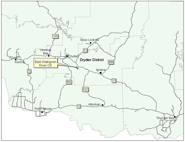
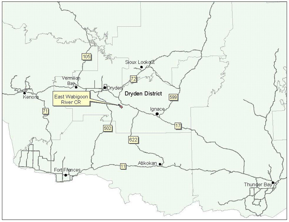
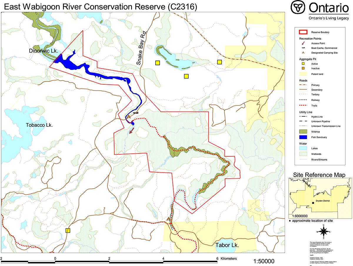
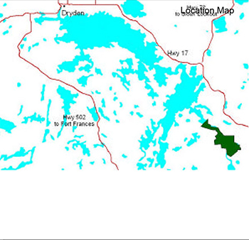
| General Location Description | The reserve is located approximately 35 km southeast from the City of Dryden (45 km by road). It encompasses the section of the Wabigoon River and surrounding wetland starting at the east end of the Wabigoon First Nation’s Reserve, just off of Dinorwic Lake. It ends approximately 15 km upstream from there. |
| Access | A boat launch to get into the river exists approximately 4 km down on the west side of Snake Bay Rd., off of Hwy 17. |
Table 1.2: Representation Targets – A summary of earth science, life science, cultural resource values and present or possible recreational opportunities.
| Life Science Representation |
Upland Forest/Forested Dunes: Wetland: |
|---|---|
| Earth Science Representation | Bedrock: (Archean rocks) Portions of the greenstone belt, altered basalt ,volcanic rock, felsic, siliceous rock which is green in colour Surficial Geology: Downstream from road – glaciolacustrine material (bedded sands and gravel with coarse boulder component) of Pleistocene age Upstream – Recent organic, alluvial deposits |
| Cultural Value Representation | No known cultural values exist within the reserve. |
| Recreational Opportunities | Opportunity exists for boating, canoeing, fishing, hunting, gathering/collecting wild rice and other nature activities. |
Table 1.3: Survey Information – Overview of inventories completed, their level of detail and any inventories that are needed.
| Survey Level | Life Science | Earth Science | Cultural | Recreational |
|---|---|---|---|---|
| Reconnaissance | - Life Science Checklist, 2002 | - Earth Science Checklist, 2002 | - not required | - Recreation Checklist, 2002 |
| Detailed | - not required | - not required | - not required | - not required |
Figure 1: General location of the East Wabigoon River Conservation Reserve
Enlarge Figure 1: General location of the East Wabigoon River Conservation Reserve
2.0 Values to be protected
This section provides a description of the key natural heritage values on the site, their condition relative to past resource and management activities, and their sensitivity to future land use and management activities.
Table 2.1: Values identified on the East Wabigoon River Conservation Reserve.
| Life Science |
|
|---|---|
| Earth Science |
|
| Cultural |
|
| Aboriginal |
|
| Tourism |
|
| Recreational Fishing | Permitted only on the east side of the bridge as a fish sanctuary exists on the west side. |
| Recreational Hunting | Permitted; WMU #9A |
| Trapping | DR04N02201, DR04T02301 – both are in use |
| Bear Management Area | DR-9A-017, DR-9A-018 |
| Bait Harvesting | 495922 |
| Commercial Fishing | N/A |
2.2 Values to be protected
The intent of this SCI is to protect the following values by establishing management guidelines for existing and potential uses in this area given the level of past disturbance and the nature of the existing features.
2.2.1 Forest values
Thirty-four hectares within the reserve contain 113-year-old intermediate black spruce, which meet the criteria for old growth. (Foster et al, 2002)
2.2.2 Biological values
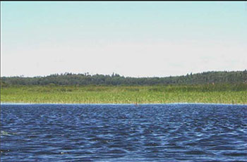
The reserve has a good diversity of open wetlands. The wetlands have a probable ranking of provincially significance but have not been officially evaluated. The wild rice is considered to have ecological and cultural significance, being used as food for waterfowl as well as people. A fish sanctuary exists east of the bridge on Snake Bay Road from April1 to May31. Giant blue hyssop, a western prairie species belonging to the mint family was found along a disturbed south-facing bank on the Wabigoon River. (Foster et al, 2002)
2.2.3 Landform values
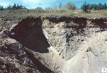
Due to erosion, the altered mafic volcanic rock underlying the reserve rarely appears at the surface. It can, however, be seen within this reserve in small outcrops. Shallow water glaciolacustrine deposits in the form of bedded sand and gravel with course boulders were found in the gravel pit within the reserve.
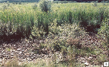
Figure 2: Example of thicket swamp found on reserve.
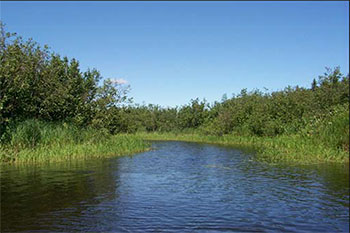
Deep water lacustrine deposits in the form of clay banks run along the Wabigoon River. Recent Age alluvial (organic) deposits can be found along the levees of the Wabigoon River. The aforementioned were considered to be of local significance. (Blackburn, 2002)
2.2.4 Recreational values
The existing canoe route, river, edible aquatic foods, wetland vegetation, mixed coniferous/deciduous forest and wildlife are considered to be recreation features contained within this reserve. Present and potential recreational activities include boating, canoeing, fishing, hunting, trapping, collecting/gathering and nature activities. Feature significance was considered to be low and none of the features were considered sensitive to recreational use based on the activities listed. (See Appendix E)
2.2.5 Tourism values
One commercial boat cache exists on the Wabigoon River, within the Conservation Reserve.
3.0 Management guidelines
3.1 Land tenure
The East Wabigoon River Conservation Reserve consists of and is surrounded mostly by Crown land. Some patent land blocks exist just south of the reserve.
The reserve will remain Crown land and no additional dispositions (including Land Use Permits or Licenses of Occupation) will be issued for the site.
The disposition of adjacent Crown Land will be dealt with on a case-by-case basis.
Unauthorized occupations of lands within the conservation reserve will be handled in accordance with approved policy, and any required structural removal will be at the owner’s expense.
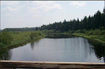
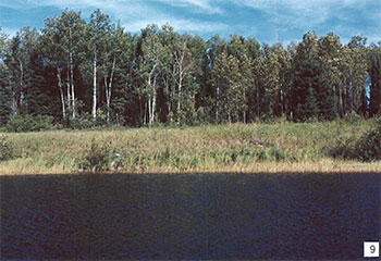
Figure 3: View from the bridge facing east, of the Wabigoon River.
3.2 Existing and proposed development
According to the Natural Resource Values Information System (NRVIS), a number of old forest access roads can be found leading into the reserve. For the most part, these are overgrown and almost impassable due to lack of upkeep. The Snake Bay Road bisects the reserve in the west arm. A one-lane bridge passes over the river at this point. The majority of the reserve’s upland area was harvested in the 1950s and 1960s. These were replanted with mostly jack pine and spruce. A clearing exists on the north shore of the river presumably from a former logging camp (Foster et al, 2002). The remains of a water control structure can be found at the narrows on Wabigoon River. Additionally, an inactive aggregate pit within the reserve can be seen from the river northeast of the bridge.
Facility infrastructure and development for recreational and/or educational purposes may be considered in the future if there is a demonstrated demand for such facilities. All provincial policies that guide development on Crown Land are applicable in Conservation Reserves.
A more detailed management plan would be required prior to any development occurring. Such a plan would have to ensure that there would be no negative impacts to any habitat or ecosystem pertinent to the values protected in this reserve.
3.3 Recreational activities
Most recreational activities that have traditionally been enjoyed in this area can continue provided they pose no threat to the natural ecosystems and features protected by the Conservation Reserve. Those uses that are regulated include hunting, fishing and trapping. Most other permitted activities are non- regulated (i.e. canoeing, exploring). See Section 2.2.4 for the recreational uses for this Conservation Reserve as determined by the Recreation Resource Inventory.
Recreational boat caches will continue to be a permitted use. New applications will be reviewed subject to a test of compatibility with the conservation of the ecological features of the site. In addition, the Northwest Region Boat Cache Program Guidelines will also apply.
Mechanical travel within the reserve, including the use of snowmobiles and All Terrain Vehicles, is permitted only on existing roads and trails. Off trail mechanized travel is permitted for retrieval of game only.
3.4 Commercial activities
No new activities, such as commercial logging, hydroelectric power development, new transmission lines (e.g. power or communications), pipelines, highways or roads, and the extraction of minerals, aggregate or peat will be permitted.
Resource user boat caches for the commercial harvest of natural resources (baitfish, commercial fur and wild rice) under a valid license, will continue to be a permitted use. New applications will be reviewed subject to the test of compatibility. In addition, the Northwest Region Boat Cache Guidelines will also be followed.
An examination of the possible impact of activities on adjacent lands should be evaluated in the Forest Management Plan.
3.5 Aboriginal interests
East Wabigoon River Conservation Reserve (C2316) lies within Treaty 3 area. The Wabigoon Lake Ojibway Nation Reserve makes up the upper west boundary on the west arm of the reserve. Wild rice harvesting occurs within the reserve.
To date, no Aboriginal Groups have voiced any issues in regards to this conservation reserve. Nothing in this Statement of Conservation Interest affects in any way existing or future Aboriginal or treaty rights.
3.6 Natural Resources Stewardship
Natural Resource Stewardship involves the consideration of the following specific natural resource management categories.
3.6.1 Vegetation management
Management within the conservation reserve will allow for the continuation of natural ecosystem processes and functions with minimal human interference.
Forest fire suppression will be carried out in accordance with the approved Fire Management Strategy for the surrounding lands. "Light on the Land" suppression techniques which do not unduly disturb the landscape will be encouraged where feasible. Examples of "light on the land" techniques may include limiting the number of trees felled or the use of heavy equipment or foam.
Opportunities for prescribed burning to achieve ecological or resource management objectives may be considered. These management objectives will be developed with public consultation prior to any prescribed burning, and reflected in the document that provides management direction for this conservation reserve. Plans for any prescribed burning will be developed in accordance with the MNR Prescribed Burn Planning Manual, and the Class Environmental Assessment for Provincial Parks and Conservation Reserves (approval pending).
The reserve is susceptible to edge and upstream effects due to its small size and riverine habitat. This sensitivity is increased by the reserves close proximity to current logging practices. It is recommended that this be taken into consideration during forest management planning in adjacent areas.
Forest insect and disease management will continue as on surrounding Crown lands.
3.6.2 Fish and Wildlife Management
The existing Wildlife Management Unit, sport fishing regulations and management activities will apply. Currently a fish sanctuary exists from April1 to May31 west of the bridge on Snake Bay Road.
3.6.3 Landforms
None of the landforms mentioned will be altered by landform modification activities such as filling and extraction. The extraction of aggregates, peat and similar materials are not permitted. Mineral exploration and extraction are not permitted in the CR.
3.7 Cultural resources stewardship
To fully manage and protect sites, field surveys are required. To date, there have been no surveys done to assess cultural or heritage values. However, common knowledge of the area suggests there to be no such values on this site, thus Cultural Inventories were deemed unnecessary.
3.8 Client services
Given the focus on low key management, client information will be given on an inquiry basis only and will deal with the basic level of information with respect to access, natural heritage appreciation, recommended activities and boundaries.
3.9 Research
Non-destructive research by qualified individuals will be encouraged to provide a better understanding of the natural values protected by the Conservation Reserve and to advance protection, planning and management.
Figure 4: Wild rice marsh.
In order to assist with enhancing the management guidelines for the reserve, the collection of additional earth and life science information during research is also encouraged.
All research programs will require the approval of the Ministry of Natural Resources as will the removal of any natural or cultural specimen. The establishment of permanent plots, observation points or facilities must also be approved and be compatible with the Conservation Reserve protection objective. Any site disturbed by research activities must be rehabilitated as closely as possible to its previous state.
3.10 Marketing
Awareness of the Conservation Reserve is promoted through the Living Legacy web site. Intensive management activity to increase use is not required at this time.
4.0 Implementation
Implementation of this Statement of Conservation Interest will primarily involve monitoring activities to ensure adherence to the management guidelines and responding to inquiries about the site.
Implementation of this statement and management of the reserve are the responsibility of the Wabigoon Area Supervisor. Partnerships may be pursued to address management needs.
5.0 Review and revisions
5.1 Review and revisions
This Conservation Reserve Statement of Conservation Interest will be reviewed on an ongoing basis.
If changes in management direction are needed at any time, the significance of the changes will be evaluated and further consultation a possibility. Any major amendments will require full public consultation and the approval of the District Manager and Regional Director. Affected clients will be immediately informed of proposed changes to this Statement of Conservation Interest.
5.2 Public consultation
5.2.1 Results of past consultations
Consultation on the East Wabigoon River Conservation Reserve was conducted as part of the consultation on the Ontario’s Living Legacy Land Use Strategy, July 1999. Subsequent consultation also took place in June 2001 to refine the boundary of the Conservation Reserve.
District Manager letters, totaling 92, were sent to the Dryden Forest Management Co., Weyerhaeuser and Ontario’s Forest Industries Association, Tourist Outfitters, Advisory Committees, Trappers, Land Owners, Members of the Public, NGOs and GOs. Newspaper ads were placed in the Ignace Driftwood June 20, 2001and Dryden Observer on June 19, 2001.
First Nation Consultation letters were also sent to ten Native communities/organizations including the Wabigoon Lake Ojibway Nation, Eagle Lake First Nation and Aboriginal People of Wabigoon. Direct consultation with Treaty 3 First Nations was carried out on a regional basis and conclude November of 2002.
A concern regarding permitted uses was voiced from one of the stakeholders. As a result of the consultation process, no analysis of the issue was required. No responses have been received to date from any of the First Nations Groups.
5.2.2 Present and future consultation
More widespread consultation is not deemed necessary at this time.
5.2.3 Author
This Statement of Conservation Interest was prepared by Alicia H.L. Morin, OLL Intern, Information Management, Dryden District. Assistance was provided by Martin Pell (Dryden District Planner) and members of the Wabigoon Area Team.
6.0 References
Blackburn, C. 2002. Earth Science Inventory – East Wabigoon River Conservation Reserve. Unpublished report.
Foster, R. and Harris, A. 2002. Life Science Inventory – East Wabigoon River Conservation Reserve. Unpublished report.
Ontario Ministry of Natural Resources (OMNR). 1999. Ontario’s Living Legacy Land Use Strategy. Queen’s Printer for Ontario.
Ontario Ministry of Natural Resources (OMNR). 2002. East Wabigoon River Conservation Reserve (C2316) Recreation Resource Inventory Report. Unpublished report.
Ontario Ministry of Natural Resources (OMNR). Lands & Natural Heritage, Lands & Waters Branch. 1997. Conservation Reserve Policy and Procedure PL 3.03.05.
Appendix A: East Wabigoon River Conservation Reserve (C2316) Values Map

Enlarge East Wabigoon River Conservation Reserve (C2316) Values Map
Appendix B: East Wabigoon River Conservation Reserve (C2316) Aerial Photo Image
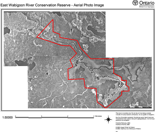
Enlarge East Wabigoon River Conservation Reserve (C2316) Aerial Photo
Appendix C: East Wabigoon River Conservation Reserve (C2316) Earth Science Checksheet
Detailed Information for Site C2316 East Wabigoon River
Protection history
The reserve was identified under the provincial Lands for Life - Ontario’s Living Legacy Program as containing "wild rice stands, a fish sanctuary, and a marsh and swamp wetland complex. It is part of the Stormy Lake canoe route." (OMNR 1999).
No previous earth science significance was assigned.
Setting
The reserve comprises 1300 hectares, and is located in Dryden MNR District. Elevations range from 370 to 390 m a.s.l. Although named after the Wabigoon River, much of the eastern portion encompasses the Kawashegamuk River which enters from the south into confluence with the Wabigoon River.
Earth science features
Bedrock geology
The entire East Wabigoon River Conservation Reserve was included in the southeast portion of mapping of the larger Dryden-Wabigoon area (Satterly 1943), and a very small portion at the southwest corner of the Dyment area (Satterly 1960). Outcrop density is low in the reserve (about 5%).
Archean rocks
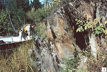
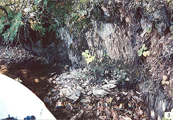
The reserve is situated in the centre of the Eagle-Wabigoon-Manitou lakes greenstone belt. The greenstone belt lies within the 900 km long, Archean age Wabigoon subprovince, at its western end (Blackburn et al 1991: Figures 9.2 and 9.8). Regional geological studies suggest that this central portion of the belt in which the reserve lies is structurally complex. Multiple folding on a large scale, shearing associated with a wide southeasterly-trending zone beneath Kawashegamuk Lake to the southeast of the reserve, and intrusion of numerous subvolcanic plutons close by, have all culminated in widespread alteration of the volcanic rocks on the reserve. Low outcrop density in the reserve limits good observations to the few exposures along the Wabigoon River. Volcanic rocks are dominantly basalts that have been sheared and altered to varying degrees. At a constriction on the Wabigoon River (station 1: photo 1) that in recent previous times was a small rapids, as indicated on geological Map 50e (Satterly 1943), basalts have been sheared and carbonatized. Weathering of the rock has resulted in oxidation of fine-grained disseminated pyrite (photo 2). Nearby (station 3), river-bank erosion has exposed very schistose, highly altered volcanic rocks of probable basaltic origin (photo 3). Although about 2 km outside and to the southwest of the reserve (station 7), similarly heavily altered volcanic rocks observed during the present reconnaissance along an abandoned forest access road, are representative of rocks of felsic composition that have been mapped (Satterly 1943) within the reserve: the rocks, although siliceous, can be scratched with a knife, due to the intense carbonatization that has also imparted a pale green colour.
Proterozoic rocks
Outcrop of a west-northwest trending diabase dike of Proterozoic age has been mapped (Satterly 1943) in two places, both to the north of the Wabigoon River, one inside the reserve at its northwest end, the other just outside the reserve near the former rapids. This single dike is similar to those of a swarm of northwest-trending dikes variously called the Kenora-Fort Frances (Osmani 1991) or Kenora-Kabetogama (Southwick and Halls 1987) swarm, that cross the Lake of the Woods region.
Surficial geology
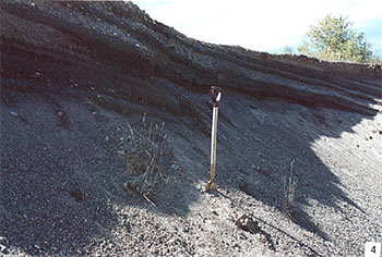
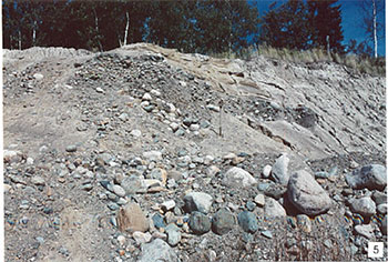
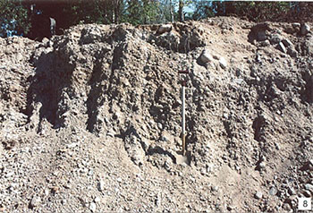
Quaternary deposits of the East Wabigoon River Conservation Reserve are of both Pleistocene age and Recent (Holocene) age. Downstream from the vicinity of where the Snake Bay forest access road crosses the Wabigoon River, glaciolacustrine materials of probable Pleistocene age predominate, while upstream of this point Recent organic deposits underlie the swamp wetland complex mentioned in the Land Use Strategy (OMNR 1999). Interpretations by previous workers (Roed 1980; Cowan and Sharpe 1991) differ in detail, but follow this general pattern. The glaciolacustrine deposits are both of shallow water, probable shoreline, and of deep water type. All glaciolacustrine sediments were likely deposited in glacial Lake Agassiz, which covered much of northwest Ontario in early postglacial time. Shallow water deposits observed in a borrow pit in the reserve (station 5) are predominantly bedded sands and gravels (photo 4), with a coarse boulder component (photo 5). Adjacent to this pit a cobble beach lies at a lower elevation, along the edge of the swamp wetland complex (photo 6). About 1 km south of the reserve along the Snake Bay road (station 6), another borrow pit is excavated in similar material: however, unsorted cobble to boulder till overlies the bedded deposits (photos 7and 8). On Map 1774A (Cowan and Sharpe 1991) these deposits are interpreted to be of glacial outwash origin.
Deep water deposits are exposed in clay banks along the river edge (station 2: photo 9 and station 4: photo 10). This bank erosion appears to be related to the constriction in the river in this area where bedrock elevations are relatively higher, resulting in outcrops over which rapids ran in the recent past as discussed above.
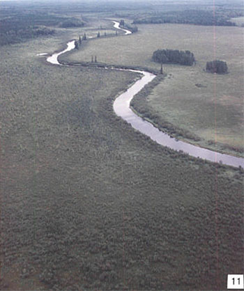
In the wetland complex, Recent alluvial deposits are represented along levees that margin the Wabigoon River, particularly upstream of its confluence with Kawashegamuk River (photo 11): the course of this portion of Wabigoon River is more stabilized than that of the Kawashegamuk River, where very sinuous meanders are evident in aerial photos (e.g. 97-4919-A; 57-10).
Significance
Mafic volcanic rocks that underlie the reserve have mostly been sheared and altered, and represent a distinctive suite of Archean volcanic rocks. Because such rocks are easily eroded they very rarely appear at surface except in small outcrops, such as in this reserve. They do represent a local occurrence of this feature, and as such are considered to be of local significance only.
The one outcrop within the reserve of a Proterozoic diabase dike is possibly the only representative in the park system of this single dike that crosses this portion of northwestern Ontario. Although the condition of the outcrop was not investigated during the present survey, its uniqueness makes it of regional significance.
Shallow water glaciolacustrine deposits exposed in the gravel pit within the reserve are locally significant as representative of this material, while clay banks along the river are of local significance as representing deep water lacustrine material.
Recent alluvial deposits exhibited in the levees along Wabigoon River are of local significance.
Sensitivity
Bedrock is not subject to degradation by either human activity or natural processes. As demonstrated by the gravel pit within the reserve, sands and gravels are subject to degradation by human activity: however, the pit does serve to expose such deposits for observation. Fine grained sediments such as the glaciolacustrine silts and clays may be highly susceptible to enhanced erosion should the anchoring vegetation cover be disturbed. The levees that margin the course of the Wabigoon River upstream of its confluence with Kawashegamuk River may be susceptible to erosion by use of the waterway by motor powered boats.
Recommendations
Conservation Reserve status serves to prevent further exploitation of the gravel resources, which if allowed to continue, could also have impact on the wetland complex for which this reserve was set aside. Conservation Reserve status may help prevent degradation of the levees: however, continued use of the waterway by motor powered boats may have adverse affects on this natural feature.
The present survey has adequately identified both bedrock and surficial features. No further recommendations for inventory are made.
References
Blackburn, C.E., Johns, G.W., Ayer, J. and Davis, D.W. 1991. Wabigoon Subprovince; in Geology of Ontario, Ontario Geological Survey, Special Volume 4, Part 1, p. 303-381.
Cowan, W.R. and Sharpe, D.R. 1991. Surficial Geology, Wabigoon Lake, Ontario; Geological Survey of Canada, Map 1774A, scale 1:100 000.
OMNR 1999. Ontario’s Living Legacy: Land Use Strategy; Ontario Ministry of Natural Resources, 136 p., accompanied by map, scale 1:1 200 000.
Osmani, I.A. 1991. Proterozoic mafic dike swarms in the Superior Province of Ontario; in Geology of Ontario, Ontario Geological Survey, Special Volume 4, Part 1, p. 661-681.
Roed, M.A. 1980. Northern Ontario Engineering Geology Terrain Study, Data Base Map, Wabigoon Lake; Ontario Geological Survey, Map 5059, scale 1:100 000.
Satterly, J. 1943. Dryden-Wabigoon area; Ontario Geological Survey, Map 50e, scale 1:63 360.
Satterly, J. 1960. Dyment area; Ontario Geological Survey, Map 1960h, scale 1:31 680.
Southwick, D.L. and Halls, H. 1987. Compositional characteristics of the Kenora- Kabetogama dike swarm (Early Proterozoic), Minnesota and Ontario; Canadian Journal of Earth Sciences, v. 24, p. 2197-2205.
Photographs
1. Constriction in the Wabigoon River at former rapids over mafic volcanic outcrops seen on either bank. (Stn. 1; UTM 0539169E 5492425N)
2. Sheared and carbonatized mafic volcanics in outcrop seen in photo 1 (right side). Note rusty weathering due to oxidation of pyrite. (Stn. 1; UTM 0539169E 5492425N)
3. Schistose, highly altered mafic volcanics exposed in a river bank. (Stn. 3; UTM 0539056E 5492567N)
4. Well bedded sands and gravels in a pit on the east side of the Snake Bay (Stn. 5; UTM 0539402E 5491529N)
5. Coarse bouldery material overlain by well bedded sands. Same pit as in photo 4. (Stn. 5; UTM 0539402E 5491529N)
6. Cobble beach at the edge of the pit in photos 3 and 4. View is to the south over wetlands of the Wabigoon River, seen at the top of the (Stn. 5; UTM 0539402E 5491529N)
7. Shallow dipping bedded gravel and bouldery material overlain horizontally by a 1 m layer of unsorted till ground moraine. (Stn. 6; UTM 0537950E 5490798N)
 m layer of unsorted till ground moraine.">
8. Unsorted bouldery till ground moraine in same pit as photo 7. (Stn. 6; UTM 0537950E 5490798N)
9. Clay bank on the Wabigoon River downstream of the bridge on the Snake Bay road. The level meadow may have been a pasture land. (Stn. 2; UTM 0538948E 5492911N)
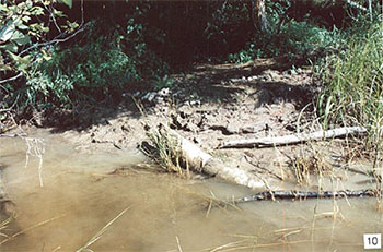
10. Clay bank erosion on the Wabigoon River downstream of the bridge on the Snake Bay road. (Stn. 4; UTM 0539380E 5492293N)
11. Levees on the Wabigoon River, above its confluence with Kawashegamuk River, looking east.
Earth Science Inventory Checklist
| Name: | "East Wabigoon River" |
|---|---|
| OLL ID: | C2316 |
| Map Name | Dyment |
| NTS Number | 52F/09 |
| UTM Reference | Z15 540000E 549 |
| OBM Number | |
| Latitude | 49° 34' N |
| Longitude | 92° 26' W |
| Elevation - Max | 390 m |
| Elevation - Min | 370 m |
| County | District of Kenora |
| Township | Satterly, Melgund |
| Lot | N/A |
| Concession | N/A |
| Area (ha) | 1,300.00 |
| Ownership | Crown |
| Air Photos: Year-Roll-Flight Line-Number | 97-57-4918A-70; 97-57-4919A-07 to 10; 97-68-4920A-105 to 108 |
| MNR Region | Northwest |
| MNR District | Dryden |
| Park Zone | Northwest |
| Earth Science Features | Archean age, Wabigoon Subprovince: entire site is underlain (< 5% outcrop) by highly altered (carbonatized and/or sericitized, commonly schistose) mafic metavolcanic rocks of the Wabigoon Lake greenstone belt. Proterozoic: West-northwest trending diabase dike represented in one outcrop. Quaternary: deposits are Recent organic material, overlying Pleistocene glaciolacustrine clays and muds, with pockets of glaciofluvial outwash sands and gravels that have been exploited in a gravel pit within the reserve; a possible cobble beach deposit is located at the interface of glaciofluvial and lacustrine deposits adjacent to the gravel pit. |
| Significance | Sheared and altered mafic volcanic rocks, although poorly exposed, are of local significance. One outcrop of a Proterozoic diabase dike that is possibly the only such dike that crosses this part of northwestern Ontario, makes it of regional significance. Shallow water glaciolacustrine deposits exposed in the gravel pit are of local significance. Clay exposed in banks exposed along the river are of local significance. Recent alluvial deposits in levees are of local significance. |
| Sensitivity | Bedrock is not sensitive to natural or cultural impacts. Sands and gravels are subject to exploitation: however, the pit does serve to expose materials for observation. Levees on the Wabigoon River may be susceptible to erosion by continued use of waterway by motor powered boats. |
| Recommendations | Further exploitation of the gravel pit could impact on the wetlands for which this reserve was established: conservation reserve status will prevent this. Continued use of the waterway by motor powered boats could adversely affect the natural levees. |
| Major References | Blackburn et al 1991, "Wabigoon Subrovince" in OGS Special Volume 4; Cowan and Sharpe 1991, GSC Map 1774A; Roed 1980, OGS Map 5059; Satterly 1943, OGS Map 50e; Satterly 1960, OGS Map 1960h. |
| Date Compiled | February 15, 2003 |
| Compiler | C.E. Blackburn, Blackburn Geological Services |
Map for Earth Science Inventory Checklist.
Ontario Ministry of Natural Resources, Ontario Parks
300 Water Street, Peterborough, Ontario K9J 8N1
Appendix D: East Wabigoon River Conservation Reserve (C2316) Life Science Checksheet
C2316 East Wabigoon River
Natural Heritage Area – Life Science Checksheet
| Name: | East Wabigoon |
|---|---|
| Map Name | Dyment |
| Map Number | 52F/9 |
| UTM Reference | Zone 15 540000 E 5490000 N |
| County | Kenora |
| Latitude | 49° 34 ' N |
| Longitude | 92° 26 W |
| NAD | 83 |
| Minimum Altitude | 370 m |
| Maximum Altitude | 390 m |
| Locality | 35 km SW of Dryden |
| Township | Satterly, Melgund |
| Area | 1300 ha |
| Ownership | Crown |
| MNR Region | Northwest |
| Ecoregion and Ecodistrict | 4S-4 |
| Landform Unit | See Table 3 |
| MNR District | Dryden |
| Aerial Photographs Year-Roll-Flight Line-Numbers |
97-A-4920 68-105 to 107 97 4919-A 57-07 to 109 |
Map for Natural Heritage Area – Life Science Checksheet.
Physical and biological features
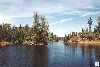
C2316 is located along the lower reaches of the Wabigoon River east of Kagiwiosa Bay on the east shore of Dinorwic Lake. Kawashegamuk River and two smaller tributaries join the Wabigoon from the south. The reserve is characterized an alluvial plain with low relief, having only 20 m of elevational change. Marshes comprise 52% (671 ha) of the reserve, water accounts for another 10% (132 ha), and the remaining 40% is mainly upland forests (Photo 1).
The reserve includes well-developed wetland toposequences, from open-water marshes to forested conifer swamps. The main channels of the Wabigoon and Kawashegamuk rivers are deep (~ 2m) and poorly vegetated, but are fringed by open-water marshes with submergents such water milfoil where the current is reduced. These are interspersed with floating-leaved marshes (W4) with yellow water lily, floating-leaved burreed, water smartweed, and floating-leaved pondweed. Extensive emergent marshes with wild rice (W9) are found along the Wabigoon River in the western part of the reserve, and along the Long Lake River in the east. Emergent marshes dominated by common cattail (W11) are found on floating to semi-grounded mats along the edge of the rice, and the margins of meadow marshes (Photo 2). In sheltered areas of shallow water with less flow, mixed marshes with arrowheads, cattails, bulrushes, and water hemlock are found.
Broad meadow marshes and shore fens flank the emergent marshes. Meadow marshes are mainly dominated by lake, beaked, and other robust sedges (W11), with abundant sweet gale, calla lily, marsh cinquefoil, and swamp candles. These hummocky meadow marshes are grounded on over 1 m of humic peat, on top of clay. They often have typical fen species such as bog willow, leatherleaf, and bog buckbean. North of the Wabigoon River, these grade into low shrub fens with Sphagnum moss, marsh horsetail, and bog rosemary. With a lower water table and increasing peat depth of fibric peat, these are replaced by intermediate conifer swamps with a tamarack and black spruce overstorey. Labrador tea, dwarf raspberry, and three-leaved false Solomon’s seal are abundant in the understorey. Along the Long Lake River, broad shore fens dominated by wire sedge (W14) are found on floating Sphagnum mats along the edge of the wild rice and cattails. These gradually becoming grounded on clay or humic peat, and intersperse with meadow marshes. Thicket swamps of speckled alder, high bush cranberry, and red osier dogwood are found along the clay banks of the Wabigoon River above the junction with the Kawashegamuk River. The rich understorey is dominated by sensitive fern, long beech fern, meadow rue, and lake sedge. There often also a thin strip of thicket swamp at the ecotone between meadow marsh and conifer swamp as well. Rich cedar swamps (Ecosite 37), treed fens with tamarack, and poor to intermediate swamps dominated by black spruce comprise approximately 15% of the reserve.
Upland soils are mainly lacustrine clays with a thin veneer of ground moraine in a few locations. Mixed forests with balsam fir, white spruce, and trembling aspen (Ecosite 29) are found along the Wabigoon River below the bridge (Table 1). There is often a thick understorey of balsam fir, mountain maple and other shrubs. In the eastern portion of the reserve, younger (40-60 year old) forests are primarily conifer- dominated with black spruce, tamarack, jack pine and cedar (e.g. Ecosites 25, 26) and abundant feathermosses. Mixedwoods with white birch, and trembling aspen (Ecosite 28), typically also have more diverse shrub and herbaceous layers. Many of these upland areas were formerly logged (Photo 3), and the planted spruce and pine are now approximately 40 years of age, 10-15 m tall and 10-20 cm DBH. Club mosses, starflower, and bunchberry are common on feathermosses and reindeer lichens.
Representation
Table 3 summarizes representation of landform vegetation types of the East Wabigoon River Conservation Reserve for Ecodistrict 4S-4 as recently refined by Ontario Parks (Steve Kingston pers. comm.). An older version of the landform vegetation representation matrix based on the original Ontario Living Legacy gap analysis is included for comparison (Table 4).
East Wabigoon has excellent representation of open wetlands on lacustrine sediments or shallow organic deposits overlying lacustrine sediments, greater than indicated in the original or revised OLL LV) analysis. Much of the open fen, marsh, and meadow marsh complex is misclassified as treed fen in the updated GIS-derived LV)-matrix (Table 3), or as burn in the original OLL LV)-analysis (Table 4). Fire history maps and fieldwork confirm that there is no recent burn represented in the reserve. The FRI provides more accurate areas for these wetland types (Table 1).
Coniferous forests on organic deposits are also well represented in the reserve. Deciduous mixed and deciduous forests on organic deposits are dominated by alder and willows, but are less extensive than previously reported. Treed bogs reported for the reserve are actually treed fens or conifer swamp. Representation of sparse forest with broken canopy (<30%) cover is the result of budworm-killed balsam fir or past selective logging of conifers, but these areas will not likely provide long-term representation of this LV)-type.
The conservation reserve provides provincially significant representation of open wetlands, conifer forests on organic deposits, and treed fens for Ecodistrict 5S-4.
Condition
Much of the reserve has been impacted by past and current human activities. A well-used forest access road, Snake Bay Road, bisects the reserve with a bridge over the Wabigoon River. There is a small boat launch on south shore of river (north side of road) with commercial and private boat caches. There is also a designated, but primitive, campsite near the bridge. There is a small gravel pit within the reserve as well. Non-native plant species such as bull thistle are found along the roadway, gravel pit, boat launch, and other disturbed areas.
Over half of the reserve uplands were logged during the 1950s and 1960s, scarified, and replanted primarily with jack pine and spruce. As a result, much of the forest is in well-defined rows that are visible on the ground and from aerial photographs. Other upland forests were apparently high-graded for conifer in the early 1900s. There are approximately 12 km of tertiary road from past logging in the reserve and a clearing on the north shore of river from a former logging camp (Photo 4). There are also the remains of a water control structure at the narrows on Wabigoon River, presumably for log drives. A harvest block on the Wabigoon Forest was recently logged along and potentially within the southern boundary of reserve (Photo 5).
The reserve’s western boundary abuts the Wabigoon Lake Indian Reserve 27. Wild rice in the reserve is harvested by First Nation members; during field work an air boat was seen coming upriver and was used in reserve. The reserve straddles a baitfish block, three bear management areas (BMAs), and two trapline areas. There is a trapper cabin on south shore of the river in the reserve. The reserve is also likely used for waterfowl hunting although no direct evidence was observed.
Diversity
On the landform-vegetation type scale, the East Wabigoon River Conservation Reserve has relatively low forest diversity due to the due fairly uniform fine-textured soils and past logging. A total of 13 LV) types (Table 4) and 27 Ecosites (Table 1) are represented. However, East Wabigoon does have a good diversity of open wetlands, particularly marshes.
Ecological considerations
The conservation reserve provides a good example of the influence of flooding regimes and succession of wetland communities. There is a very well-developed levee along the banks of the Wabigoon River upstream of the junction with the Kawashegamuk River (Photo 6). Enough clay soil has been deposited during spring flooding to support large black spruce and a thin strip of alder thicket swamp. The ground drops away from the levee, and the saturated soils support meadow marshes. The wild rice stands, in particular, are sensitive to water level fluctuations, and are less dense and not as productive in high water years. Stumps of trees in the centre of some meadow marshes indicate the hydrology has changed over time due to flooding by beavers and possibly dams downriver. Beaver lodges and activity are common along the edges of the main channels and small dams have been built across the smaller tributaries.
Spruce budworm infestations occurred in the reserve during the late 1980s and early 1990s resulting in mortality of white spruce and balsam fir. Approximately 14 ha in the northwest corner of the reserve burned during the 1920s, but has since returned to conifer forest.
The small size and riverine nature of the reserve, as well as its proximity to logging, make it very susceptible to edge and upstream effects. Most of the watershed is outside the conservation reserve.
Special features
Although the wetland has not been officially evaluated, it would probably rank as provincially significant. The extensive wild rice stands in the reserve are significant both ecologically and culturally as a food source for waterfowl and people.
The waters of the Conservation Reserve downstream of the Snake Bay Road bridge are designated as a fish sanctuary from April 1 to May 31. Abundant minnows and other small fish were observed in shallow water throughout the reserve.
There is a bald eagle nest just outside the reserve’s southeastern boundary. Bald eagles are considered Endangered in Ontario.
Giant blue hyssop, a western species, was found on a disturbed, south-facing bank along the Wabigoon River. No other prairie species were found at this location. This species is uncommon and may be rare in the Ecodistrict 4S-4. A 10-m tall white elm was found at the clearing along the Wabigoon River.
The reserve has 34 ha of 114-134 year old intermediate black spruce swamp (Ecosite 36) that meet the criteria for old growth. It also has 6 ha of 124 year old jack pine dominated Ecosite and 45 ha of 104-114 year old aspen-dominated Ecosite 29 that meet old growth criteria.
Recommendations
Ontario Parks should continue to be actively involved in forest management planning in areas adjacent to the reserve.
Significance level and summary of major representative values
East Wabigoon includes provincially significant open wetland communities including marshes, meadow marshes and shore fens. The conservation reserve also provides significant representation of conifer forests on organic deposits and treed fens for Ecodistrict 4S-4. These include regionally significant wild rice marshes and spawning habitat for walleye, pike, muskellunge, and other fish. Noble (1995) also considered the site provincially significant.
Major information sources
Harris, A.G., S.C.McMurray, P.W.C.Uhlig, J.K.Jeglum, R.F.Foster and G.D. Racey. 1996. Field guide to the wetland ecosystem classification for northwestern Ontario. Ontario Ministry of Natural Resources., Northwest SCI. & Technology Thunder Bay, Ont. Field Guide FG-01. 74 pp. + Append.
OMNR. 1999. Ontario’s Living Legacy – Land Use Strategy. Queen’s Printer, Toronto.
Noble, T. 1980. Life science report: Phase II, Site Region 4S. Unpublished report for Northwest Region, Ontario Ministry of Natural Resources, Thunder Bay, Ont. 22 p + Append.
Noble, T. 1995. Site District 4S4 gap analysis. Unpublished report for Northwest Region, Ontario. Ministry of Natural Resources., Thunder Bay, Ont. 22 p + Append.
Racey, G.D., A.G. Harris, J.K.Jeglum, R.F.Foster and G.M.Wickware. 1996. Terrestrial and wetland ecosites of northwestern Ontario. Ont. Min. Natur. Resour., Northwest SCI. & Technol. Thunder Bay, Ont. Field Guide FG-02. 88 pp. + Append.
Sims, R.A., W.D. Towill, K.A. Baldwin, P. Uhlig and G.M. Wickware. 1997. Field guide to the forested ecosystem classification for northwestern Ontario. Ont. Min. Natur. Resour., Northwest SCI. & Technol. Thunder Bay, Ont. Field Guide FG-03. 176 p.
Uhlig, P., A. Harris, G. Craig, C. Bowling, B. Chambers, B. Naylor and G. Beemer. 2001. Old growth definitions for Ontario. Ont. Ministry of Natural Resource, Queen’s Printer for Ontario, Toronto, ON. 27 p.
Date Compiled:
21/05/03
Compiler(s):
Robert Foster, Allan Harris
Northern Bioscience
Map 1. Site map 'With significant features.
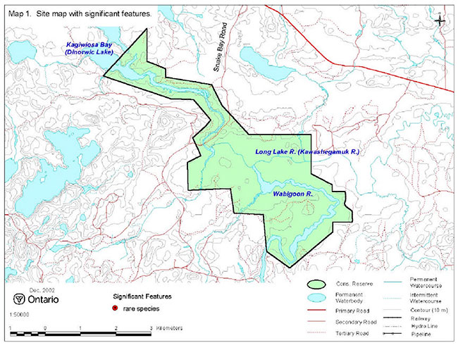
Enlarge Map 1. Site map 'With significant features.
Photo 1. Wabigoon River, peatlands and jack pine forests in eastern part of reserve.
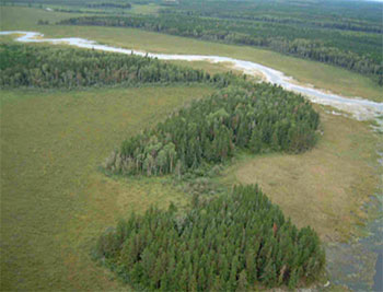
Photo 2. Open wetlands such as this shore fen with cattails dominate the reserve.
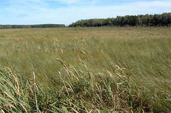
Photo 3. Mixed forest of aspen and jack pine were formerly logged.
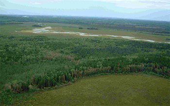
Photo 4. Clearing on Wabigoon River from old logging camp.
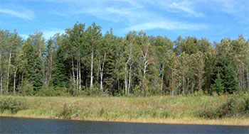
Photo 5. Wild rice marsh, backed by cattail marsh and clear cut in southeast corner of reserve.
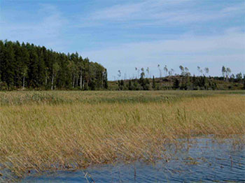
Photo 6. Levee and thicket swamp along Kawashegamuk River.
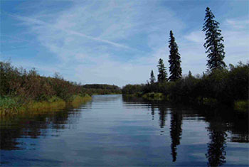
Table 1. Terrestrial ecosites of East Wabigoon River (derived from Forest Resource Inventory data provided by OMNR).
Very Shallow Soils
| Description | Area (ha) | Proportion (%)* | |
|---|---|---|---|
| ES12 | Black Spruce - Jack Pine: Very Shallow Soil | 4 | <1 |
Sandy- Coarse Loamy Soils
| Description | Area (ha) | Proportion (%)* | |
|---|---|---|---|
| ES17 | White Cedar: Fresh - Moist, Coarse - Fine Loamy Soil | <1 | <1 |
| ES18 | Red Pine - White Pine: Fresh, Coarse Loamy Soil | ||
| ES19 | Hardwood - Fir - Spruce Mixedwood: Fresh, Sandy - Coarse Loamy Soil | 19 | 2 |
| ES20 | Spruce - Pine / Feathermoss: Fresh, Sandy - Coarse Loamy Soil | <1 | <1 |
| ES21 | Spruce - Fir Mixedwood: Fresh, Coarse Loamy Soil | 10 | 1 |
| ES22 | Spruce-Pine / Ledum / Feathermoss: Moist, Sandy-Coarse Loamy Soil | 1 | <1 |
| ES23 | Hardwood Fir – Spruce Mixedwood: Moist, Sandy-Coarse Loamy Soil | 1 | <1 |
Fine Loamy – Clayey Soils
| Description | Area (ha) | Proportion (%)* | |
|---|---|---|---|
| ES25 | Pine – Spruce / Feathermoss: Fresh, Silty Soil | 66 | 5 |
| ES26 | Spruce - Pine / Feathermoss: Fresh, Fine Loamy - Clayey Soil | 126 | 10 |
| ES27 | Fir - Spruce Mixedwood: Fresh, Silty - Fine Loamy Soil | 8 | 1 |
| ES28 | Hardwood-Fir-Spruce Mixedwood: Fresh, Silty Soil | 19 | 1 |
| ES29 | Hardwood - Fir - Spruce Mixedwood: Fresh, Fine Loamy - Clayey Soil | 194 | 15 |
| ES31 | Spruce-Pine / Feathermoss: Moist, Silty-Clayey Soil | 1 | <1 |
Treed Wetlands
| Description | Area (ha) | Proportion (%)* | |
|---|---|---|---|
| ES35 | Poor Swamp: Black Spruce: Organic Soil | 53 | 4 |
| ES36 | Intermediate Swamp: Black Spruce (Tamarack): Organic Soil | 41 | 3 |
| ES37 | Rich Swamp: Cedar (Other Conifer): Organic Soil | 54 | 4 |
Open Wetlands**
| Description | Area (ha) | Proportion (%)* | |
|---|---|---|---|
| ES40 | Treed Fen MNR Code 310 - Treed Muskeg | 56 | 4 |
| ES41-43 ES46-48 | Other open wetlands (i.e., fens, shore fens, meadow marshes, marshes) MNR Codes 311 - Open Muskeg | 507 | 39 |
| ES44 | Thicket Swamp MNR Code 312 – Brush and Alder | 3 | <1 |
| Open Water MNR Code 152 – River – double line | 89 | 7 | |
| Unclassified or Other | 39 | 3 | |
* proportion of reserve
** approximated from MNR Code; ecosites not directly interpreted for these polygons.
Table 2. Rapid assessment plot summary from East Wabigoon
| Plot No. | V / W Type | ES Type | Date |
|---|---|---|---|
| 422 | W35 | ES44 | 2002/09/13 |
| 423 | W12 | ES46 | 2002/09/13 |
| 424 | W31 | ES37 | 2002/09/13 |
| 425 | W14 | ES45 | 2002/09/13 |
| 426 | W9 | ES47 | 2002/09/13 |
| 427 | V16 | ES27 | 2002/09/13 |
Table 3. Landform – vegetation (LV) type representation for Stormy Lake Conservation Reserve for Ecodistrict 4S-4 (derived from analysis by Ontario Parks; Steve Kingston pers. comm.).*
| LV_Description | Area (ha) | Ecodistrict Representation Target % |
Ecodistrict Representation Target (ha) |
Ecodistrict Protected Areas (ha) |
East Wabigoon Areas (ha) | East Wabigoon Contribution to Ecodistrict Target (%) | East Wabigoon Contribution to Existing Protection (%) | East Wabigoon Confirmed in Field |
|---|---|---|---|---|---|---|---|---|
| Glaciolacustrine deposits-Dense Deciduous Forest | 31,723 | 12 | 3,807 | 1,210 | 10 | 0 | 1 | X |
| Glaciolacustrine deposits-Mixed Forest – mainly Coniferous | 31,445 | 12 | 3,773 | 1,431 | 16 | 4 | 11 | X |
| Glaciolacustrine deposits-Dense Coniferous Forest | 19,316 | 12 | 2,318 | 1,865 | 58 | 2 | 3 | X |
| Glaciolacustrine deposits-Sparse Coniferous Forest | 16,829 | 12 | 2,019 | 1,110 | 27 | 1 | 2 | X |
| Glaciolacustrine deposits-Mixed Forest – mainly Deciduous | 13,003 | 12 | 1,560 | 421 | 28 | 2 | 7 | X |
| Glaciolacustrine deposits-Sparse Deciduous Forest | 8,249 | 12 | 990 | 111 | 9 | 1 | 8 | X |
| Organic deposits-Mixed Forest – mainly Coniferous | 3,250 | 12 | 390 | 278 | 143 | 37 | 51 | X |
| Organic deposits-Dense Deciduous Forest | 2,544 | 12 | 306 | 114 | 7 | 2 | 6 | |
| Organic deposits-Dense Coniferous Forest | 2,227 | 12 | 269 | 198 | 98 | 36 | 49 | X |
| Organic deposits-Sparse Coniferous Forest | 1,996 | 12 | 243 | 228 | 44 | 18 | 19 | X |
| Organic deposits-Mixed Forest – mainly Deciduous | 1,101 | 15 | 161 | 158 | 45 | 28 | 29 | X |
| Glaciolacustrine deposits-Treed Fen | 1,009 | 16 | 157 | 178 | 99 | 63 | 55 | X |
| Organic deposits-Treed Fen | 843 | 18 | 152 | 614 | 302 | 199 | 49 | X |
| Organic deposits-Sparse Deciduous Forest | 754 | 20 | 151 | 37 | 14 | 9 | 37 | X |
| Organic deposits-Treed Bog | 727 | 21 | 151 | 227 | 5 | 4 | 2 |
The LV matrix was recently refined by Ontario Parks in several ways: 1) revised Ecodistrict boundaries; 2) increased resolution of Landcover28 data (25 m vs. 100 m); 3) terrain is no longer used as a modifier; 4) more accurate surficial geology data; and 5) updated approach to representation targets.
Table 4. Original version of landform – vegetation (LV)) type representation for East Wabigoon Conservation Reserve used in Ontario Living Legacy gap analysis.
| Site District | Landform | Surface Expression | burn | conifer | conifer mixed | deciduous | deciduous mixed | open wetland | sparse forest | Grand Total |
|---|---|---|---|---|---|---|---|---|---|---|
| 4S-4 | Lacustrine Deposit | 249 | 53R | 168 | 45 | 18R | 264R | 52C | 849 |
C = critical to meet representation targets at the Site District level
R = contributes to representation of the LV type at the Site District level
Table 5. Site type matrix for East Wabigoon with representative ecosites (Racey et al. 1996).
Colder
| Arid | Very Dry | Dry | Dry Mesic | Mesic | Wet Mesic | Wet | Very Wet | Saturated | Open Water | |
|---|---|---|---|---|---|---|---|---|---|---|
| Rock | ||||||||||
| Sand | ||||||||||
| Loam | ||||||||||
| Clay | 36,37 | |||||||||
| Organic | 35,36,37 |
Normal
| Arid | Very Dry | Dry | Dry Mesic | Mesic | Wet Mesic | Wet | Very Wet | Saturated | Open Water | |
|---|---|---|---|---|---|---|---|---|---|---|
| Rock | ||||||||||
| Sand | ||||||||||
| Loam | 27 | |||||||||
| Clay | 31,32 | 31,32 | 36,37,44 | 44,46 | 47,49,50 | |||||
| Organic | 35,36,37,44 | 44,45,46 | 47,49 |
Warmer
| Arid | Very Dry | Dry | Dry Mesic | Mesic | Wet Mesic | Wet | Very Wet | Saturated | Open Water | |
|---|---|---|---|---|---|---|---|---|---|---|
| Rock | ||||||||||
| Sand | ||||||||||
| Loam | ||||||||||
| Clay | ||||||||||
| Organic |
East Wabigoon species lists
The following species lists are based fieldwork conducted Sept 13, 2002 and data provided by OMNR.
Plant list
Taxonomic order and species names generally follow Morton and Venn (1990). Introduced species are marked "I". Provincially rare species (Oldham 1999) are marked "P". Regionally rare species are marked "R". Voucher specimens were collected for species marked "*".
| Family Equisetaceae | Horsetail Family |
|---|---|
| Equisetum fluviatile L. | Water Horsetail |
| Equisetum pratense Ehrh | Shade Horsetail |
| Family Dryopteridaceae | True Fern Family |
|---|---|
| Dryopteris carthusiana (Villars) H.P.Fuchs | Spinulose Wood Fern |
| Family Osmundaceae | Flowering Fern |
|---|---|
| Osmunda claytoniana L. | Interrupted Fern |
| Family Thelypteridaceae | Marsh Fern Family |
|---|---|
| Thelypteris palustris (Salisb.) Schott | Marsh Fern |
| Family Lycopodiaceae | Clubmoss Family |
|---|---|
| Lycopodium annotinum L. | Bristly Clubmoss |
| Lycopodium clavatum L. | Common Clubmoss |
| Family Cupressaceae | Juniper Family |
|---|---|
| Thuja occidentalis L. | Eastern White Cedar |
| Family Pinaceae | Pine Family |
|---|---|
| Abies balsamea (L.) Miller | Balsam Fir |
| Larix laricina (Duroi) K.Koch | Tamarack |
| Picea glauca (Moench) Voss | White Spruce |
| Picea mariana (Miller) BSP | Black Spruce |
| Pinus banksiana Lambert | Jack Pine |
| Family Alismataceae | Water Plantain Family |
|---|---|
| Sagittaria latifolia Willd. | Broad-leaf Arrowhead |
| Sagittaria rigida Pursh | Stiff Arrowhead |
| Family Araceae | Arum Family |
|---|---|
| Acorus americanus L. | Sweet Flag |
| Calla palustris L. | Water Calla |
| Family Cyperaceae | Sedge Family |
|---|---|
| Carex aquatilis Wahlenb. | Water Sedge |
| Carex lacustris Willd. | Lake Sedge |
| Carex lasiocarpa Ehrh. | Wire Sedge Carex |
| Stricta Lam. | Tussock Sedge |
| Carex utriculata Boott | Beaked Sedge |
| Scirpus acutus Muhlenb . ex Bigelow | Hardstem Bulrush |
| Scirpus cyperinus (L.) Kunth | Black-sheathed Bulrush |
| Scirpus subterminalis Torrey | Floating Clubrush |
| Family Iridaceae | Iris Family |
|---|---|
| Iris versicolor L. | Wild Iris |
| Family Liliaceae | Lily Family |
|---|---|
| Clintonia borealis (Aiton) Raf. | Blue Bead Lily |
| Maianthemum canadense Desf. | Wild Lily-of-the-valley |
| Maianthemum trifolium (L.) Sloboda | Three-leaved Solomon’s Seal |
| Family Poaceae | Grass Family |
|---|---|
| Bromus ciliatus L. | Fringed Brome |
| Calamagrostis canadensis (Michaux ) P.Beauv. | Bluejoint Grass |
| Muhlenbergia mexicana (L.) Trin. | Mexican Muhly |
| Oryzopsis asperifolia Michaux | Rough-leaved Mountain Rice |
| I Phleum pratense L. | Timothy |
| Poa palustris L. | Fowl Blue Grass |
| Zizania palustris L. | Wild Rice |
| Family Potamogetonaceae | Pondweed Family |
|---|---|
| Potamogeton natans L. | Floating-leaved Pondweed |
| Family Sparganiaceae | Bur-reed Family |
|---|---|
| Sparganium emersum Rehmann | Common Bur-reed |
| Sparganium fluctuans (Morong) Robinson | Floating Bur-reed |
| Family Typhaceae | Pondweed Family |
|---|---|
| Typha latifolia L. | Common Cattail |
| Family Aceraceae | Maple Family |
|---|---|
| Acer spicatum Lam. | Mountain Maple |
| Family Apiaceae | Parsley Family |
|---|---|
| Cicuta bulbifera L. | Bulblet-bearing Water Hemlock |
| Cicuta maculata L. | Spotted Cowbane |
| Sanicula marilandica L. | Black Snakeroot |
| Sium suave Walter | Water Parsnip |
| Family Apocynaceae | Dogbane Family |
|---|---|
| Apocynum androsaemifolium L. | Spreading Dog Bane |
| Family Araliaceae | Ginseng Family |
|---|---|
| Aralia nudicaulis L. | Wild Sarsaparilla |
| Family Asteraceae | Sunflower Family |
|---|---|
| Achillea millefolium L. | Common Yarrow |
| Anaphalis margaritacea (L.) Benth. & Hook. f.ex C.B. Clarke | Pearly Everlasting |
| Aster macrophyllus L. | Large-leaved Aster |
| I Chrysanthemum leucanthemum L. | Ox-eye Daisy |
| I Cirsium arvense (L.) Scop. | Canada Thistle |
| Eupatorium maculatum L. | Joe Pye Weed |
| Helianthus maxmilianii L. | Maxmilian’s Sunflower |
| Solidago canadensis L. | Canada Goldenrod |
| Solidago nemoralis Aiton | Wood Goldenrod |
| I Sonchus arvensis L. | Perennial Sow Thistle |
| I Taraxacum officinale G. Weber | Common Dandelion |
| Family Betulaceae | Birch Family |
|---|---|
| Alnus incana (L.) Moench | Speckled Alder |
| Betula papyrifera Marshall | White Birch |
| Corylus cornuta Marshall | Beaked Hazelnut |
| Family Caprifoliaceae | Honeysuckle Family |
|---|---|
| Diervilla lonicera Miller | Bush Honeysuckle |
| Linnaea borealis L. | Twinflower |
| Lonicera oblongifolia (Goldie) Hook. | Swamp Fly Honeysuckle |
| Lonicera villosa (Michaux) Roemer & Schultes | Mountain Fly Honeysuckle |
| Symphoricarpos albus (L.) S. F. Blake | Snowberry |
| Viburnum trilobum Marshall | High-bush Cranberry |
| Family Chenopodiaceae | Goosefoot Family |
|---|---|
| I Chenopodium album L. | Lamb’s Quarters |
| Family Cornaceae | Dogwood Family |
|---|---|
| Cornus canadensis L. | Bunchberry |
| Cornus stolonifera Michaux | Red Osier Dogwood |
| Family Ericaceae | Heath Family |
|---|---|
| Andromeda polifolia L. | Bog Rosemary |
| Chamaedaphne calyculata (L.) Moench | Leatherleaf |
| Gaultheria hispidula (L.) Muhlenb . ex Bigelow | Creeping Snowberry |
| Ledum groenlandicum Oeder | Labrador Tea |
| Vaccinium angustifolium Aiton | Low Blueberry |
| Vaccinium myrtilloides Michaux | Velvet-leaved Blueberry |
| Vaccinium oxycoccos L. | Small Cranberry |
| Family Fabaceae | Pea Family |
|---|---|
| I Trifolium hybridum L. | Alsike Clover |
| I Trifolium pratense L. | Red Clover |
| Family Grossulariaceae | Currant Family |
|---|---|
| Ribes hudsonianum Richardson | Northern Wild Black Currant |
| Ribes oxyacanthoides L. | Bristly Wild Gooseberry |
| Family Guttiferae | St. John’s-wort |
|---|---|
| Triadenum fraseri (Spach) Gleason | Marsh St. Johnswort |
| Family Haloragaceae | Water Milfoil Family |
|---|---|
| Myriophyllum verticillatum L. | Bracted Water Milfoil |
| Family Lamiaceae | Mint Family |
|---|---|
| Agastache foeniculum (Pursh) Kuntze | Blue Giant Hyssop |
| I Galeopsis tetrahit L. | Common Hemp Nettle |
| Lycopus uniflorus Michaux | Northern Bugleweed |
| Scutellaria galericulata L. | Common Skullcap |
| I Stachys palustris L. | Woundwort |
| Family Menyanthaceae | Bogbean Family |
|---|---|
| Menyanthes trifoliata L. | Buckbean, Bogbean |
| Family Myricaceae | Bayberry Family |
|---|---|
| Myrica gale L. | Sweet Gale |
| Family Nymphaeaceae | Water-lily Family |
|---|---|
| Nuphar variegata Durand in Clinton | Yellow Pond Lily |
| Family Oleaceae | Olive Family |
|---|---|
| Fraxinus nigra Marshall | Black Ash |
| Family Onagraceae | Evening-primrose |
|---|---|
| Epilobium angustifolium L. | Fireweed |
| Oenothera biennis L. | Common Evening Primrose |
| Family Plantaginaceae | Plantain Family |
|---|---|
| I Plantago major L. | Common Plantain |
| Family Polygonaceae | Buckwheat Family |
|---|---|
| Polygonum amphibium L. | Water Smartweed |
| Rumex orbiculatus A. Gray | Great Water Dock |
| Family Primulaceae | Primrose Family |
|---|---|
| Lysimachia thyrsiflora L. | Tufted Loosestrife |
| Trientalis borealis Raf. | Starflower |
| Family Ranunculaceae | Buttercup Family |
|---|---|
| Anemone canadensis L. | Canada Anemone |
| Aquilegia canadensis L. | Wild Columbine |
| Coptis trifolia (L.) Salisb. | Three-leaved Gold Thread |
|
I Ranunculus acris L. |
Common or Tall Buttercup |
| Thalictrum dasycarpum Fischer & Ave-Lall. | Tall Meadowrue |
| Thalictrum dioicum L. | Early Meadowrue |
| Family Rosaceae | Rose Family |
|---|---|
| Fragaria virginiana Miller | Wild Strawberry |
| Geum aleppicum Jacq. | Common Avens |
| Potentilla palustris (L.) Scop. | Marsh Cinquefoil |
|
Prunus virginiana L. |
Chokecherry |
| Rosa acicularis Lindley | Prickly Wild Rose |
| Rubus idaeus L. | Common Raspberry |
| Rubus pubescens Raf . | Dwarf Raspberry |
| Sorbus decora (Sarg.) C.Schneider | Showy Mountain Ash |
| Spiraea alba Duroi | Narrow-leaved Meadow Sweet |
| Family Rubiaceae | Bedstraw Family |
|---|---|
| Galium labradoricum (Wieg.) Wieg. | Smooth Bedstraw |
| Family Salicaceae | Willow Family |
|---|---|
| Populus balsamifera L. | Balsam Poplar |
| Populus tremuloides Michaux | Trembling Aspen |
| Salix candida Fluegge ex Willd. | Hoary Willow |
| Salix pedicellaris Pursh | Bog Willow |
| Salix petiolaris Smith | Slender Willow |
| Family Ulmaceae | Elm Family |
|---|---|
| Ulmus americana L. | White Elm |
East Wabigoon animal species list
Taxonomic order and nomenclature follow AOU (1998) for birds and Banfield (1974) for mammals. Nesting evidence codes follow the Ontario Breeding Bird Atlas:
Possible Nesting
H - Species observed in breeding season in suitable habitat.
S – Singing male present or breeding calls heard observed in breeding season in suitable habitat.
Birds
| Grebes | Family Podicipedidae |
|---|---|
| H Pied-billed Grebe | Podilymbus podiceps |
| Cormorants | Family |
|---|---|
| H Double-crested Cormorant | Phalacrocorax auritus |
| Ducks, Geese and Swans | Family Anatidae |
|---|---|
| H Wood Duck | Aix sponsa |
| H Common Goldeneye | Bucephala clangula |
| Kites, Eagles and Hawks | Family Accipitridae |
|---|---|
| H Northern Harrier | Circus cyaneus |
| H Broad-winged Hawk | Buteo platypterus |
| Chickadees | Family Paridae |
|---|---|
| H Black-capped Chickadee | Parus atricapillus |
| Nuthatches | Family Sittidae |
|---|---|
| H Veery | Catharus fuscescens |
| Thrushes | Family Turdidae |
|---|---|
| Ulmus americana L. | White Elm |
| New World Sparrows | Family Emberizidae |
|---|---|
| H White-throated Sparrow | Zonotrichia albicollis |
Mammals
| Squirrels | Family Sciuridae |
|---|---|
| Red Squirrel | Tamiasciurus hudsonicus |
| Beavers | Family Castoridae |
|---|---|
| Beaver | Castor canadensis |
| Rats, Mice, and Voles | Family Muridae |
|---|---|
| Muskrat | Ondatra zibethicus |
Appendix E: Recreation Inventory Checksheet
Recreation Inventory Checklist
| Name: | "East Wabigoon River Conservation Reserve - C2316 " |
|---|---|
| OLL ID: | Map Name |
| Map Name | Dyment |
| NTS Number | 52F/09 |
| UTM Refernece | 15540282549058 |
| OBM Number | 15530054900, 15540054800 |
| Latitude | 49' 33 |
| Longitude | 92' 26 |
| Area (ha) | 1,299.00 |
| Ownership | Crown |
| MNR Region | Northwest |
| MNR District | Dryden |
| Park Zone | Northwest |
| County | N/A |
| Township | Satterly |
| Recreation Features | 1. T06 - Existing Canoe Route 2. M07 - River, Large 3. W00 - Wildlife, General 4. A04 - Edible Aquatic Foods 5. E08 - Wetland Vegetation 6. E05 - Mixed Coniferous/Deciduous 7. 8. |
| Recreation Activities |
1. b01 - Boating |
| Recreation Factors | Features | Rating: Very High/High/Moderate/Low/N/A |
|---|---|---|
| Most Scarce Feature: | N/A | |
| Feature Scarcity: | N/A | |
| Most Unique Feature: | 1 | |
| Activity Attraction Capability: | Low | |
| Scenic Attractiveness: | Moderate | |
| Geographic Significance: | N/A | |
| Feature Significance: Most Sensitive Feature To Recreation Use: |
N/A |
Low |
| Feature Sensitivity To Recreation Use: Most Sensitive Feature To Resource Development: |
N/A |
N/A |
| Feature Sensitivity To Resource Development | N/A | |
| Cultural/Historic and Archaelogical Features: | N/A |
Date Compiled: ay, August 04, 2002
Compiler: Alicia Morin, Ashleigh Prior
Source: Recreation Resource Inventory Stadndards and Proceedures Draft Report, Gov. of British Columbia, Ministry of Forests Range, Recreation and Forests Practices Branch, March 1995.
Ontario Ministry of Natural Resources, Ontario Parks
300 Water Street, Peterborough, Ontario K9J 8N1
Appendix F: Permitted Uses Table
Summary of Generic Permitted Uses in Conservation Reserves within the Planning Area
| Use | Existing Conservation Reserves | New Conservation Reserves in the Planning Area |
|---|---|---|
| Commercial timber harvest, commercial hydro development | Not permitted. | Not permitted. |
| Mineral exploration and mining | Not permitted. | There will be no new exploration permitted. |
| Bait fishing, commercial fishing, commercial fur harvesting, wild rice harvesting | Existing use permitted to continue, unless there are significant demonstrated conflicts. New operations can be considered, subject to the "test of compatibility". | Existing use permitted to continue unless there are significant demonstrated conflicts. New operations can be considered, subject to the "test of compatibility". |
| Sport hunting | Permitted. | Permitted. |
| Sport fishing | Permitted, except in specific fish sanctuaries. | Permitted, except in specific fish sanctuaries. |
| Seasonal recreation camps("hunt camps") | Existing camps permitted to continue, and may be eligible for enhanced tenure, but not purchase of land (see 6.1.8). | Existing authorized camps permitted to continue, and may be eligible for enhanced tenure but not purchase of land (see 6.1.8). |
| Commercial Bear Hunting | Existing use permitted to continue. New operations not permitted. | Existing use permitted to continue. New operations not permitted. |
| Tourism facilities (for resource-based tourism) and recreational trails | Existing authorized facilities and trails can continue, unless there are significant demonstrated conflicts. No new tourism facilities permitted. New trails can be considered as part of planning for an individual reserve. | Existing authorized facilities and trails (motorized and non-motorized) can continue, unless there are significant demonstrated conflicts. Tourism facilities can apply to upgrade tenure from LUP to lease. New tourism and trail facilities can be considered as part of planning for an individual reserve. |
| Land Disposition | Sale of lands is not permitted. Renewals of existing leases or land use permits are permitted; requests for transfer of tenure will be considered in the context of the Statement of Conservation Interest or Resource Management Plan. New leases or land use permits permitted for approved activities. | Sale of lands is not permitted. Renewals of existing leases or land use permits are permitted; requests for transfer of tenure will be considered in the context of the Statement of Conservation Interest or Resource Management Plan. New leases or land use permits permitted for approved activities. |
| Roads | Existing roads can continue to be used, but new roads for resource extraction will not be permitted. | Existing roads can continue to be used, but new roads for resource extraction will not be permitted, with the exception of necessary access for mineral exploration and development. |