Emily Provincial Park Management Plan
This document provides direction on the management of Emily Provincial Park.
Ministry of Natural Resources
Additional copies of this publication are obtainable from:
Ministry of Natural Resources
10670 Yonge Street Richmond Hill, Ontario
L4C 3C9
© 1985, Government of Ontario
"We are pleased to approve the Emily Provincial Park Management Plan, as official policy for the management and development of this park. The plan reflects this Ministry’s intent to protect natural features of Emily and maintain and develop high quality opportunities for outdoor recreation and heritage appreciation for both residents of Ontario and visitors to the Province."
Signed by:
M. Fordyce
Regional Director
Central Region
N. Richards
Director, Parks and
Recreational Areas Branch
1. Introduction
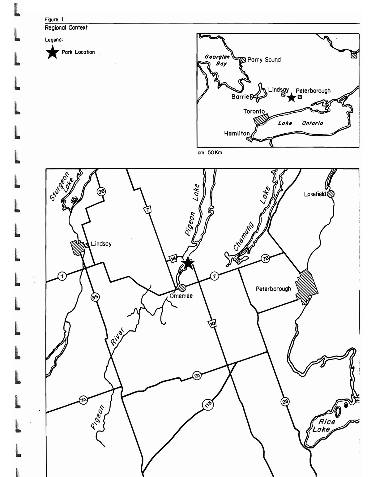
Emily Provincial Park (hereafter referred to as "Emily" or "the park") is located in one of the prime outdoor recreation areas for the Province of Ontario, namely the Kawartha Lakes Region (see Figure 1). This region’s recreational potential is based on its landscape aesthetics, water and land-based recreational opportunities, and its proximity to Metro-Toronto and other urban centres to the south and west. From 1980 to 1983, day-use attendance increased by 8% to approximately 17,000 visitors annually. During this same period, camper nights increased 2%. In addition, Emily is located on the Trent-severn waterway. This waterway corridor, consisting of locks, rivers and lakes, is considered a provincially-significant recreational resource, providing water access between Lake Ontario and Georgian Bay.
More specifically, Emily is situated on the east shore of Pigeon River, in the Township of Emily, County of Victoria. The park is approximately 22 km northwest of the City of Peterborough and approximately 130 km northeast of Metro-Toronto.
The park contains a land base of 69 hectares (see Section 3.4, Park Boundary).
The park’s present land holding was acquired in two separate transactions. First, approximately 29 hectares of land at the northern end of· the park were transferred to the Crown by Emily Township in 1956. Development started immediately in this area, with the land being declared a provincial park in 1957. The second transaction involved approximately 40 hectares acquired in 1966.
It is for the purpose of planning, development and management of the park’s natural and recreational resources that this management plan is being prepared.
2. Summary of significant issues and policy decisions
Recent construction work on County Road 10, along the park’s eastern boundary has altered the existing roadside drainage patterns. As a result, areas of the park, once adequately drained by the roadside ditch, are now experiencing inadequate drainage. Site planning measures within the park and outside of the park (in conjunction with the county road officials) will be initiated to alleviate this problem.
3. Park policies
3.1 Park classification
The classification of Emily is "recreation" in recognition of the park’s recreational facilities and opportunities.
3.2 Park goal
To maintain and operate Emily as a recreation-oriented provincial park providing opportunities that utilize the park’s resource base and providing access to the provincially significant Trent-severn waterway.
3.3 Park objectives
3.3.1 Recreation objective
The recreation objective of the Ontario Provincial Parks system is to provide outdoor recreation opportunities ranging from high-intensity day use to low-intensity wilderness experiences.
Figure 1. Regional context

Enlarge Figure 1. Regional context
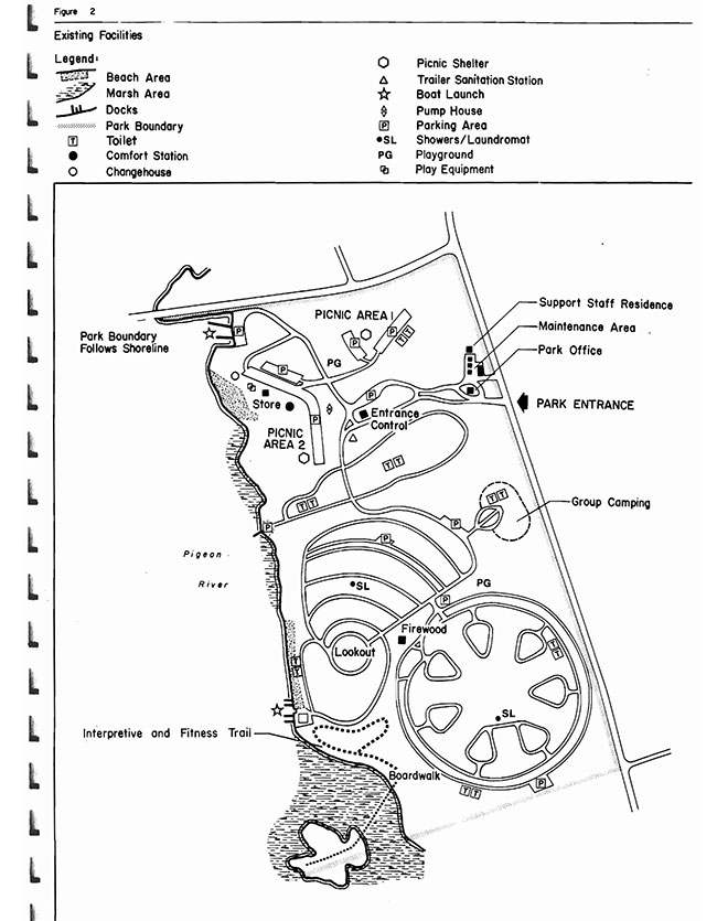
Figure 2. Existing facilities
Enlarge Figure 2. Existing facilities
The recreation objective of this park is to provide and encourage day use and camping opportunities that utilize the area’s prime recreational potential while being compatible with the park’s natural resources and its land base.
According to the Lindsay District Land-Use Guidelines:
- the park’s 299 campsites are estimated to represent 16% of the district’s campsite opportunities to the year 2000 (they presently provide 24% of the district’s campsite opportunities)
- the park’s 133 metres of beach are estimated to represent 3.6% of the district’s swimming opportunities to the year 2000 (they presently provide 15.9% of the district’s swimming opportunities) and
- the park’s 200 picnic tables are estimate to represent 7.8% of the district’s picnic table target to the year 2000 (they presently provide 16% of the district’s picnick table opportunities)
(N.B.) The difference in camping, swimming and picnicking percentile opportunities between present day and the year 2000, represents an estimated increase in the number of similar opportunities to be made available elsewhere and does not reflect any proposed decrease in facility-based opportunities at Emily.
3.3.2 Heritage appreciation objective
The heritage appreciation objective of the Ontario Provincial Parks system is to provide opportunities for exploration and appreciation of the outdoor natural and cultural heritage of Ontario.
The heritage appreciation objective of this park is to provide a range of opportunities for the exploration, interpretation and appreciation of the natural features of the park and to present to park visitors a variety of resource management messages relating to Ministry of Natural Resources mandates. Interpretive facilities and programs will vary according to the significance of the resource, its accessibility and its required level of management (see Section 5.1.3).
3.3.3 Protection objective
The protection objective of the Ontario Provincial Parks system is to protect provincially significant elements of the natural and cultural landscape of Ontario.
The protection objective of this park is to protect the wetlands along the shoreline of the park through zoning that is sensitive to the particular resource management needs of this feature as well as to the recreational pressures placed on these features.
3.3.4 Tourism objective
The tourism objective of the Ontario Provincial Parks system is to provide Ontario’s residents and out-of-province visitors with opportunities to discover and experience the distinctive regions of the Province.
The tourism objective of this park is to provide Ontario’s residents and out-of-province visitors with opportunities to discover and experience the Kawartha Lakes Region and the Trent-Severn Waterway.
The park in 1979 contributed slightly more than one and a half million dollars to the provincial economy through park expenditures and tourist spending. It is the objective of the ministry to maintain and possibly increase the economic contribution of this park to the local economy.
3.4 Park boundary
The park’s 69 hectares refers to its landbase. However, regulation of the park includes 83 hectares. The difference involves· the park’s offshore waters which are actually under federal jurisdiction. A working agreement with the Trent-Severn Waterway will be negotiated in order for the park to obtain authorization for management of the offshore area. The final dimension and size of this extension of the park’s jurisdiction will be determined during these negotiations. The present unofficial waterlot extends 92 metres from shore and includes 14 hectares.
3.5 Zones and zone policies
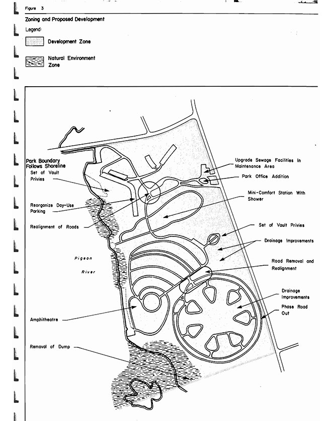
All lands within the park will be zoned (see Figure 3) in recognition of their existing and potential environmental qualities, required protection and their potential for recreation and interpretive use within the context of the overall four objectives.
3.5.1 Development zone
- This zone encompasses the majority of the park’s land base. Facilities for day use, camping and park administration/maintenance and associated open space are located in this zone
Development zone policies
- To improve the landscape aesthetics and the environmental quality of this zone
- To maintain the present level of development, allowing for facility improvements and limited expansion
3.5.2 Natural Environment zone
- Although not significant, the three areas included under this zone are biologically interesting areas associated with the shoreline marshes, waters of Pigeon River, and wet woodlands
Natural environment zone policies
- To protect the natural features from detrimental forms of development and recreational use
- To allow appropriate forms of recreational activities to occur, such as canoeing and hiking along established trails
- To allow approved resource management activities to occur
- To allow natural vegetation succession to occur except for extreme cases (e.g., infestations of insects and diseases) where vegetative management is proved to be of benefit to the healthy existence of the indigenous vegetative community
4. Resource management
4.1 Landform and water management
- The beaches will be replenished with sand as needed
- site planning measures will be initiated to alleviate the drainage problems occurring in the park
Figure 3: Zoning and proposed development
Enlarge Figure 3: Zoning and proposed development
4.2 Vegetation management
- Management of existing vegetation and proposed planting projects including a mowing program will be addressed in a Vegetation Management Plan. The planting program will be concerned with:
- using native plant species with wildlife attracting characteristics
- phasing out the presently established short-lived species and replacing with longer living and more desirable species
- the siting of trees on the western side of the lookout hill in order to preserve the existing view overlooking Pigeon River
- increasing vegetation buffers between campsites, where necessary
- more effective screening of campsites from County Road 10
- establishment of a vegetative barrier along the southern boundary of the park
- Measures (e.g., mechanical, chemical) may be used to alleviate the aquatic weed problem in the vicinity of the docks and at the beach
- Mowing will be discontinued on grassed areas that are not required to be maintained for park purposes or aesthetic reasons. Natural regeneration of these areas may be assisted with the planting of species as well as scarification to encourage seeding in
- Acceptable management procedures involve controlling native and non-native insects and diseases that threaten the values for which the park was established or values outside of the park
- Insects and diseases which do not threaten the existence of the plant communities will be allowed to develop undisturbed in all zones of the park. Where control is desirable, it will be directed as narrowly as possible to the specific insect or disease so as to have minimal effects on other components of the park’s environment
- Attempts will be taken to protect those significant vegetative communities and plants as listed in "A Reconnaissance Biological Inventory of Emily Provincial Park" (see Appendix A, Emily Provincial Park Background Information Document)
4.3 Fauna management
- Sport fishing will be encouraged offshore from the park
- When the park receives authorization to manage its offshore waters, commercial fishing and bait fishing will not be allowed in these waters
- Nuisance animal control (e.g., dogs, skunks, etc.), if necessary, may be carried out under the strict supervision of or directly by the Ministry of Natural Resources
- The district fish and wildlife staff will continue to monitor the osprey nesting platform located in the park. Platform installation and monitoring is part of an overall district-wide study to gather information and ultimately improve osprey nesting. Waterfowl management to date has involved the installation of wood duck nesting boxes. With the recent construction of a boardwalk through the marsh, a major interpretive theme for the park is wetland management with emphasis on waterfowl and osprey nesting. waterfowl hunting will not be allowed within park boundaries because of
- the small size of the marsh
- demand for waterfowl hunting is local only and is satisfied elsewhere along the Pigeon River; and
- the marsh boardwalk is promoted for interpretive use
5. Client services management
5.1 Visitor services
- Emily, as a popular recreation-oriented provincial park, provides a wide variety of quality visitor service opportunities. The goal is to provide visitors with a system of basic information and a variety of family-oriented recreational facilities and programs. Of the four visitor service components (i.e., communication, recreation, interpretation and outdoor education) the former two are emphasized at the park
5.1.1 Communication
Objectives of this component should include the following:
- informing visitors about the park, its services, facilities and management concerns
- informing visitors about recreation and interpretive opportunities in the local area
- informing visitors of the role of the Ministry of Natural Resources
- instilling a sense of respect in visitors for the park environment
- providing a means of feedback for visitors to communicate with the Ministry
The objectives outlined above will be achieved through all or some of the following: publications, signs, audio-visual presentations, displays, mass media and personal contact including campsite visitation.
5.1.2 Recreation
The park’s self-use and staff-led recreation activities will include:
- water-oriented self-use recreation with a waterfront for sunbathing, swimming and boating. water-oriented recreation will be emphasized because of the park’s limited land base and because of the park’s access to the outstanding recreational opportunities provided by Pigeon River and the Trent-Severn Waterway System. The park will provide self-use facilities oriented to the water (e.g., boat launches, boat rentals, docks, beaches, picnic grounds)
- to supplement the park’s recreation facilities, a free recreation equipment loan program may be offered
- limited staff-led recreation activities may be provided as funds and staff priorities permit. They may include campfire, craft and water-oriented programs. Such programs should lead to an involvement with the natural features of the park
5.1.3 Interpretation
The major theme to be interpreted will deal with resource management. Examples of programs that can be offered under this theme include wetland management (includes waterfowl and osprey management), forestry (e.g., Emily Tract Forest, Smokey Bear and Fire Fighting Crew), fisheries (e.g., Kawartha Fishery) and land-use planning (e.g., C.O.R.T.S.[Canada-Ontario-Rideau Trent Severn System])
A minor theme is outdoor recreation, with the Kawartha Lakes and C.O.R.T.S. being emphasized. These two themes are considered to be of local to regional significance and will be resented through various media, Self-use interpretive opportunities will include the park nature trail, boardwalk and trail guides.
Interpretation may also be offered through staff-led recreational activities such as special events/demonstrations and programs planned for the proposed amphitheatre (see Development and Implementation Section 6).
5.1.4 Outdoor education
Park staff will encourage local and regional school boards to make educational use of the park' resources.
5.2 Recreation management
- During off-season, when the park’s facilities are closed, park patrons have access to the park’s land base for recreational pursuits (e.g., walking, cross-country skiing, tobogganing, etc.)
- Future recreational growth will be based on water-oriented activities since the recreational potential of the park’s land base has almost been maximized
- Demand for mooring facilities by users of the Trent-Severn Waterway System will be monitored and if a demand is proven, mooring facilities may be provided
- Park activities and facilities will be directed by guidelines and procedures in accordance with the Emily Management/Operating Plan
- Park patrons will be encouraged to use recreational opportunities and facilities outside the park, as well as inside the park
- Park patrons' motorized vehicles, bicycles, snowmobiles and all-terrain vehicles (A.T.V.'s) will operate on roads
Recently considerable damage has occurred to park trees and buildings by snowmobiles and their operators and if this continues, the machines may be banned from the park entirely.
5.3 Commercial services
The following commercial services are available at the park:
- firewood concession
- fast food/store concession
- laundry
- boat rental
Additional concessions may be added or existing ones modified in some way, according to the need and within policy guidelines.
5.4 Marketing
The following is a list of this park’s marketing strategies:
- Continued use of outside groups for special events, i.e. Paddlecade, Red Cross
- Increase use of staff-led programs such as film presentations on Ministry programs. Encourage use of marsh boardwalk
- Increase awareness of nearby facilities such as Victoria County Forest, Trent-Severn Waterway access
- Implement programs using guest speakers on topics related to Emily setting, i.e. Peterborough Drumlin Field, birds in area, history of area
- Encourage campers to use park as a base for exploring local area, history of area
- Maintain a canoe/boat rental concession in the park
- Continue to keep all park facilities in clean and safe
6. Development and implementation
Though the park has a diverse and fully developed range of facilities, the following development proposals are justified in order to:
- improve the efficiency of operating/maintaining the park
- enhance recreational experiences
- upgrade existing facilities
- accommodate increased use
- improve aesthetics
The development proposals for Emily in descending priority are:
- Upgrading sewage system in maintenance area
- Provision of two extra sets of vault privies - one in group campground area, and one in the vicinity of the concession in the day-use area
- Provision of a "mini comfort station" with showers in the Cedars Campground Area will be investigated
- Improvements to the drainage of the circle and group camping areas
- Reorganize parking in the day-use area
- Realignment of roads in the vicinity of the gatehouse
- Provision of an amphitheatre
- Park office addition
- Realignment and removal of some roads in the circular camping areas
- Removal of the dump and rehabilitation of site
Planting of trees and shrubs is not given a priority listing since it is a project which is ongoing, and is phased in as The initiation of a Vegetation Wildlife Management Plan will be given top priority.
7. Public consultation
Public consultation during the management planning process for Emily focused on the local area and included the following:
- a news release and advertisement in the Peterborough Examiner, Lindsay Post and Lindsay This Week advising that this management plan was available for review at the park and/or district office
- copies of this plan forwarded to local levels of government for review (Village of Omemee, Township of Emily, Victoria County Council, Kawartha Region Conservation Authority)
- copies of the news release sent to interest groups (Cavalake Catering, Fees Landing Resort, Riverview Marina)
- where appropriate, contact will be made with adjacent landowners, by park management, to inform these landowners of the plan and its contents
- announcements and posters were on display in the park during the summer of 1984 advising park visitors of availability of plan for review
All comments and suggestions received from the public were considered while finalizing this plan.
This management plan will be reviewed when major issues surface and at least once within the next ten years. Any necessary plan amendments will be made with public involvement in accordance with apparent needs.
8. References
Burns, J. A.; Archaeological Survey of Emily Provincial Park, Emily Township, Victoria County, Ontario, 1977, Ministry of Natural Resources.
Crowe, McKay, Baker; The Tourist and Outdoor Recreational Climate of Ontario, Volumes 1, 2 and 3, 1977, Fisheries and Environment Canada.
Ontario Ministry of Natural Resources; Submission to Victoria County, Official Plan.
Ontario Ministry of Natural Resources; 1983 Provincial Park Day-User Survey - Summary Statistical Report, 1984, Outdoor Recreation Group.
Ontario Ministry of Natural Resources; 1983 Provincial Camper Survey - Summary Statistical Report, 1984, Outdoor Recreation Group.
Ontario Ministry of Natural Resources; Lindsay District Land Use Guidelines, 1983.
Ontario Ministry of Natural Resources; Emily Provincial Park Management Plan - Background Information Document, 1984.
Victoria County Planning Board, The County of Victoria Planning Area; Summary of Background Reports, Goals and Objectives, 1977.
Victoria County Planning Board, The County of Victoria Planning Area; Official Plan, 1978.