Fallingsnow Lake Conservation Reserve Management Statement
This document provides policy direction for the protection, development and management of the Fallingsnow Lake Conservation Reserve and its resources.
Fallingsnow Lake Conservation Reserve C2268
Statement of Conservation Interest
Ministry of Natural Resources
Lakehead Area, Thunder Bay District
October 2000
Approval statement
We are pleased to approve this Statement of Conservation Interest for Fallingsnow Lake Conservation Reserve.
This Statement of Conservation Interest provides guidance for the management of the conservation reserve and the basis for the ongoing monitoring activities. More detailed direction is not anticipated at this time. Should significant facility development be considered or complex issues arise requiring additional studies, more defined management direction, or special protection measures, a more detailed Conservation Reserve Management Plan will be prepared with full public consultation.
The public was widely consulted during the designation and regulation of the site and further consultation is not required at this time.
The conservation reserve will be managed under the jurisdiction of the Lakehead Area Supervisor, Thunder Bay District, Ministry of Natural Resources.
Signed by:
Charlie Lauer
Regional Director
Northwest Region
Date: April 12, 2001
Signed by:
Jim Adams
Acting District Manager
Thunder Bay District
Date: April 2, 2001
1.0 Background information
The purpose of this document is to identify and document the natural heritage values of Fallingsnow Lake Conservation Reserve, the activities that occur there and, through a set of management guidelines, lay out the activities that will and will not be permitted. For more information regarding this Statement of Conservation Interest (SCI) please refer to the "Conservation Reserve Policy and Procedure PL3.03.05", specifically pages 2-6 and 14-22 of the procedure.
Background Information
| Name | Fallingsnow Lake Conservation Reserve |
| Site Region / Site District | 4W - 2 |
| OMNR Administrative Region / District / Area | Northwest Region / Thunder Bay District / Lakehead Area |
| Total Area (ha) | 854 ha |
| Regulation Date | March 2001 |
| First Nations | Robinson Superior 1850 Treaty Fort William First Nation |
| OBM | 20 16 2900 53300 |
| Lat./Long. | 48º08' N 89º46' W |
| Basemap | 482894 / 481894 NTS – 52A/4 - Scale 1:50 000) |
| Forest Resource Inventory Stands | 9151, 9256, 9558, 9762, 9860, 9756, 1475, 1372, 1167, 0265, 0560, 1764, 1659, 1656, 2063, 2565, 2155, 2862, 2348, 3048, 2845, 3143, 3140, 2735, 3331, 3561, 4556, 4052, 4849, 4049, 4445, 3843, 4643, 4439, 4337, 4733, 3929, 5827, 5229, 5221, 6123. |
| General Location Description | Located approximately 45 km southwest of Thunder Bay, in the township of Devon. |
| Access | Follow Highway 595 south through South Gillies. Turn right on Pearson Twp Sideroad. Proceed straight for about 4 km then stay to the left at the fork in the road. |
1.1 Representation targets
This section provides a summary of the earth science, life science and cultural resource values, as well as present or possible recreational opportunities.
| Life Science Representation |
|
| Earth Science Representation |
|
| Cultural Value Representation |
|
| Recreational Opportunities |
|
1.2 Inventory status
This section provides an overview of the inventories completed, their level of detail, and any further inventories that are needed.
| Survey | Reconnaissance Inventory | Future Requirements |
|---|---|---|
| Life Science | Yes – Geowest, 2000 | No |
| Earth Science | Yes – Geowest, 2000 | No |
| Cultural | Values reviewed – 2000 | No |
| Recreational | Yes – 2000 | Monitor on an ongoing basis |
2.0 Values to be protected
This section provides a description of the key natural heritage values on the site, their condition relative to past resource and management activities, and their sensitivity to future land use and management activities.
2.1 Values identified on the site
| Life Science |
|
| Earth Science |
|
| Cultural | None identified |
| Aboriginal | None identified |
| Tourism | There are presently no existing tourism or interpretive facilities. |
| Recreational Fishing |
|
| Recreational Hunting | Used by local residents for moose and small game hunting. |
| Mining | Low potential; no significant site concerns (DLUG, 1983) |
| Aggregate | No past or existing operations, little potential. (DLUG, 1983) |
| Forest Harvest | The area has been removed from the SFL (Greenmantle). |
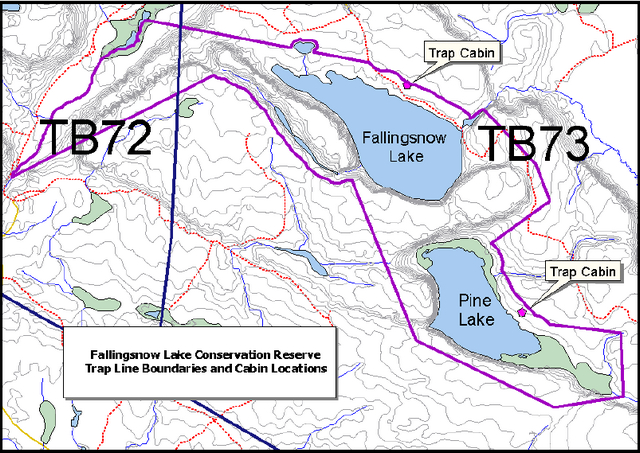
| Trapping | Two licensed trap-lines in the site are active (TB73 and TB72) with two trap cabins in use (belonging to TB73). |
| Bear Management Area | The conservation reserve is part of two active Bear Management Areas (TB-13-029, TB-13-027). |
| Bait Harvesting | Fallingsnow Conservation Reserve lies within one licensed bait block (# 9). |
| Commercial Fish | None |
2.2 Values to be protected
The intent of this SCI is to protect the following values by establishing management guidelines for existing and potential uses in this area given the level of past disturbance and the nature of the existing features.
2.2.1 Forest values
No recent forestry operations have occurred within the Conservation Reserve boundaries, and the forest in the entire area is to be protected from any future harvest operations. The site contains representative vegetation types, including mixed–wood forest types and open wetland.
2.2.2 Landform values
The mesa-cuesta topography and its associated bedrock ridges and talus slopes enhance the aesthetic appeal of Fallingsnow Lake Conservation Reserve.
Thick poorly to very poorly drained organic and fluvial lacustrine deposits, found around Pine Lake, are extremely sensitive to disturbance.
2.2.3 Recreational values
The conservation reserve offers camping, hiking, snowshoeing, nature appreciation, sport hunting and fishing opportunities.
2.2.4 Tourism values
This unique and highly attractive area has the potential for eco-tourism opportunities however consideration must be given to the protection of the lake trout fishery.
3.0 Management guidelines
3.1 Land tenure
Fallingsnow Lake Conservation Reserve consists of, and is entirely surrounded by Crown land.
The conservation reserve will remain Crown land and no dispositions (including Land Use Permits or Licenses of Occupation) will be issued for the site.
The disposition of adjacent Crown Land will be dealt with on a case-by-case basis.
Unauthorized occupations of lands within the conservation reserve will be handled in accordance with approved policy, and any required structural removal will be at the owner’s expense.
3.2 Existing and proposed development
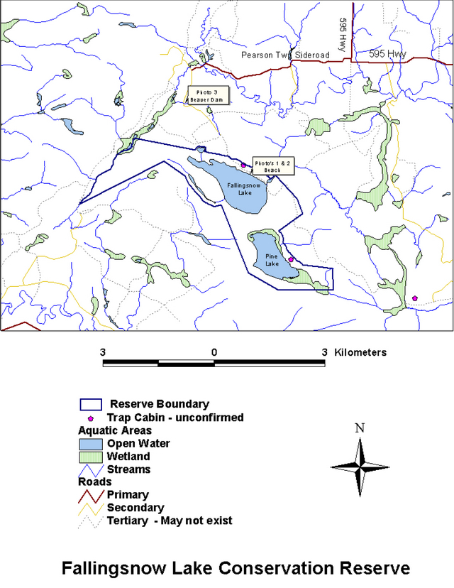
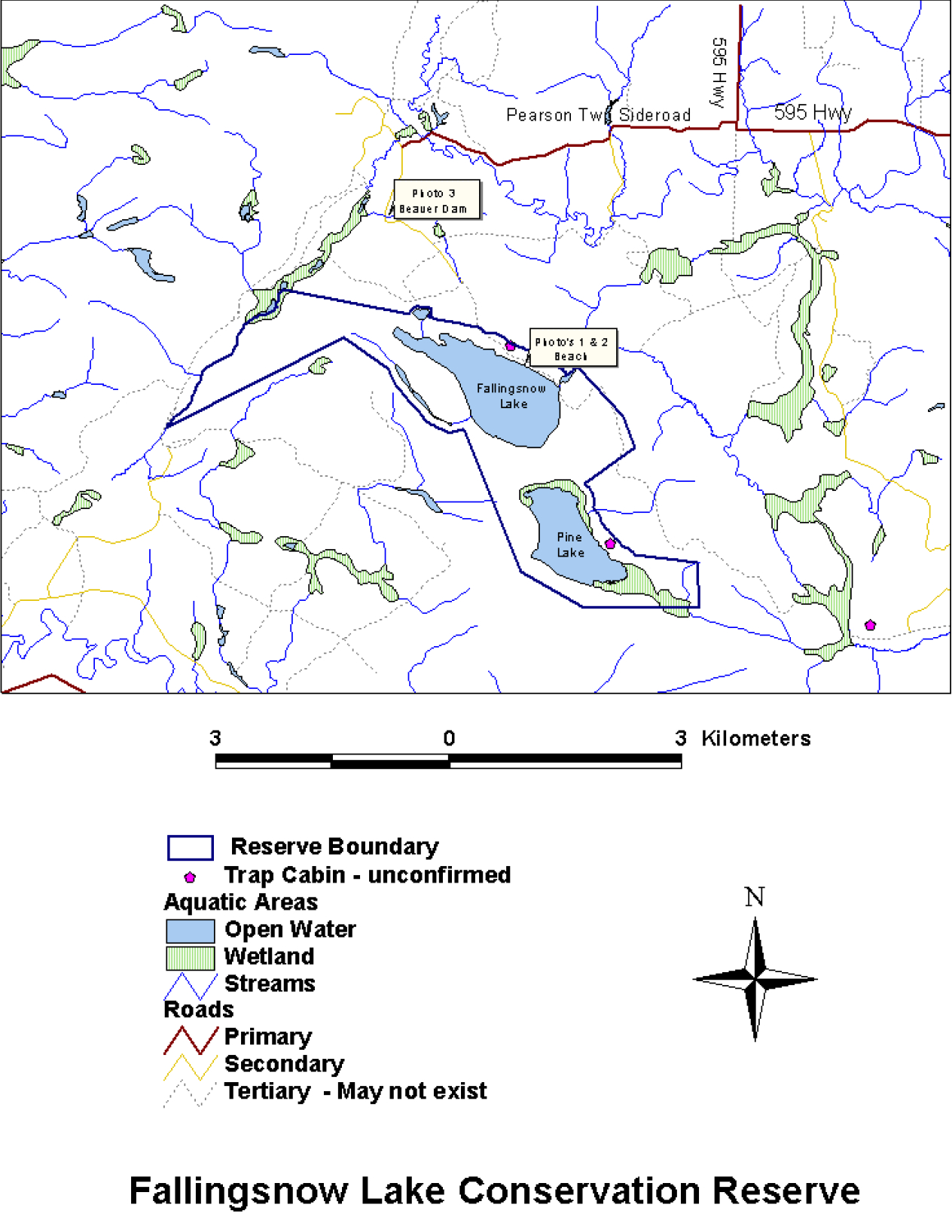
At present, old logging roads on the North side of Fallingsnow Lake provide the only point of access. Although a collapsed beaver dam may limit vehicle access at a point approximately 2 km from the conservation reserve boundary, users are crossing this section at their own risk. It is for-seen that they will continue to do so as vehicle access is preferable by users who intend to launch a boat from the smooth bedrock shoreline or camp overnight at one of the informal camp sites. With exception of the beaver dam, the road is otherwise passable to the shore of Fallingsnow Lake.
There are no existing, privies, formal boat launches, parking lots or waste disposal sites and only informal campsites exist.
In an effort to ensure minimal impact on the natural features of the conservation reserve while still allowing for recreational use, it is recommended that there be no road maintenance. Users will attempt to cross at their own risk and Fallingsnow Lake Conservation Reserve may eventually be accessible only by ATV, snowmobile or on foot.
New trails are not encouraged, however, they may be considered when compatible with other recreational uses and the maintenance of environmental integrity. Any new trails will be designed to discourage access by any means other than on foot and will avoid those areas around Pine Lake identified as sensitive to disturbance.
Facility infrastructure and development for recreational and/or educational purposes may be considered in the future if there is a demonstrated demand for such facilities. A more detailed management plan would be required prior to construction.
All provincial policies which guide development (i.e. water hazard management, shoreline development, wetlands) are applicable in conservation reserves as on Crown land.
3.3 Recreational activities
Most recreational activities that have traditionally been enjoyed in this area can continue provided they pose no threat to the natural ecosystems and features protected by the Conservation Reserve. Non-regulated permitted uses include wildlife viewing, hiking, snow-shoeing, camping, cross country skiing, snowmobiling, canoeing and boating. Hunting and fishing may continue as a regulated use.
Mechanized travel is permitted only on the existing roads and bush trail. Off trail mechanized travel is permitted for retrieval of game only.
3.4 Commercial activities
The Fallingsnow Lake Conservation Reserve is located within the Lakehead Forest and has been withdrawn from the Sustainable Forest License currently held by Greenmantle. An examination of the possible impact of activities on adjacent lands should be evaluated in the Forest Management Plan.
The conservation reserve has been withdrawn from all mining exploration and extraction activities by MNDM at MNR's request.
This Conservation Reserve is part of two registered trap-lines (TB72 and TB73). Both are presently active and will be permitted to continue unless any significant conflicts are identified. New trap-lines may be considered, however associated trails should be reviewed. There are two trap cabins located on the site (TB73). New cabins will not be permitted.
The area is part of two Bear Management Areas (TB13-029, TB13-027). Hunting may continue in this conservation reserve.
The Conservation Reserve is part of a licensed bait block (#9). Bait harvesting will be permitted to continue.
No new activities, such as mining, commercial logging, hydroelectric power development, new transmission lines (e.g. power or communications), pipelines, highways or roads, and the extraction of aggregate or peat, will be permitted.
3.5 Aboriginal interests
There is no known past or current aboriginal interest in the Fallingsnow Lake Conservation Reserve. Nothing in this Statement of Conservation Interest affects in any way existing or future aboriginal or treaty rights.
3.6 Natural resources stewardship
Natural Resource Stewardship involves the consideration of the following specific natural resource management categories.
3.6.1 Vegetation management
Management within the conservation reserve will allow for the continuation of natural ecosystem processes and functions with minimal human interference.
The forest in the entire area is to be protected from any human alteration. Forest fire protection will be carried out on the Conservation Reserve as on surrounding public lands, with a "light on the land" approach (ie. no bulldozers, no camp construction, minimal cutting).
Forest insect and disease management will continue as on surrounding Crown lands.
3.6.2 Fish and wildlife management
Existing Wildlife Management Unit and sport fishing regulations and management activities will apply.
3.6.3 Landforms
The mesa-cuesta topography and its associated bedrock ridges and talus slopes are a predominant landform feature at Fallingsnow Lake Conservation Reserve.
Thick poorly to very poorly drained organic and fluvial lacustrine deposits, found around Pine Lake, are extremely sensitive to disturbance.
No management activity is required except protection.
3.7 Cultural resources stewardship
No management activity is required at this time based on existing information.
3.8 Client services
Given the focus on low key management, client information will be given on an inquiry basis only and will deal with the basic level of information with respect to access, natural heritage appreciation, recommended activities and boundaries.
3.9 Research
Non-destructive research by qualified individuals will be encouraged to provide a better understanding of the natural values protected by the Conservation Reserve and to advance protection, planning and management.
The collection of additional earth and life science information for the purpose of enhancing the management guidelines is a priority.
All research programs will require the approval of the Ministry of Natural Resources as will the removal of any natural or cultural specimen. The establishment of permanent plots, observation points or facilities must also be approved and be compatible with the Conservation Reserve protection objective. Any site disturbed by research activities must be rehabilitated as closely as possible to its previous state.
3.10 Marketing
Awareness of the Conservation Reserve is promoted through the Living Legacy web site. Intensive management activity to increase use, is neither desired nor required at this time.
4.0 Implementation
These management guidelines are implemented by the Lakehead Area Team, Thunder Bay District. Any affected clients will be immediately informed of proposed changes to this Statement of Conservation Interest.
5.0 Review and revisions
5.1 Review and revisions
Fallingsnow Lake Conservation Reserve Statement of Conservation Interest will be reviewed on an ongoing basis.
If changes in management direction are needed at any time, the significance of the changes will be evaluated and consultation may be required, as determined by the Area Supervisor. Any major amendments will require full public consultation and the approval of the Regional Director.
This Statement of Conservation Interest complies with all requirements of the Environmental Assessment Act and the Environmental Bill of Rights. Environmental Assessment Declaration Order MNR – 65, dated February 2, 2000, permits designation of specific listed areas as Conservation Reserves, and allows for interim management of those areas. The undertaking of management of the Conservation Reserve will be in conformity with this policy and all other existing Crown land E.A. exemptions.
5.2 Public consultation
5.2.1 Results of past consultation
Consultation on the proposed Fallingsnow Lake Conservation Reserve was conducted as part of the consultation on the Ontario’s Living Legacy Land use Strategy, July 1999. Subsequent consultation also took place in 2000 to refine the boundary of the Conservation Reserve.
A pre-consultation letter was sent to Fort William First Nation in June 2000 followed by a formal "invitation to participate" in August 2000. In November 2000, District staff met with the Chief, Band Manager, and land claim representative. Fallingsnow is within the traditional use area of Fort William First Nation.
A district information package was distributed to known interested and affected people in August 2000 along with an "invitation to participate" newspaper advertisement placed in the local paper. No comments were received and no issues were identified.
5.2.2 Present and future consultation
More widespread consultation is not deemed necessary at this time.
5.2.3 Author
This Statement of Conservation Interest was prepared by Tracy Moore, OLL ResourceManager Intern, Thunder Bay District.
6.0 References
Bentz, Jerry, Dennis O'Leary and Amit Saxena, 2000. Earth and Life Science Checklists for Selected Conservation Reserves and Provincial Parks in the Thunder Bay District. Geowest Environmental Consultants Ltd., 120 pp.
Land Resource Research Institute, 1981. Soils of the Thunder Bay Area. Soil Survey Report 48 - Kakabeka Falls 52 A/5. Department of Energy, Mines and Resources.
Natural Heritage Information Centre, 2000. /page/ministry-natural-resources-and-forestry.
Ontario Ministry of Natural Resources, 1997. Conservation Reserve Policy and Procedure.PL 3.03.05. 22 p.
Ontario Ministry of Natural Resources, 1999. Ontario’s Living Legacy – Land Use Strategy.136 p.
Ontario Ministry of Natural Resources, 1989. Thunder Bay District Fisheries Management Plan 1988 – 2000. 104 p.
Ontario Ministry of Natural Resources, 1983. Thunder Bay District Land Use Guidelines. 108 p.
Ontario Ministry of Natural Resources, 2000. NRVIS – Natural Resource Values Information System.
Appendices
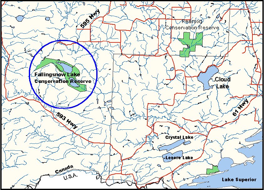
Appendix A- Regional setting
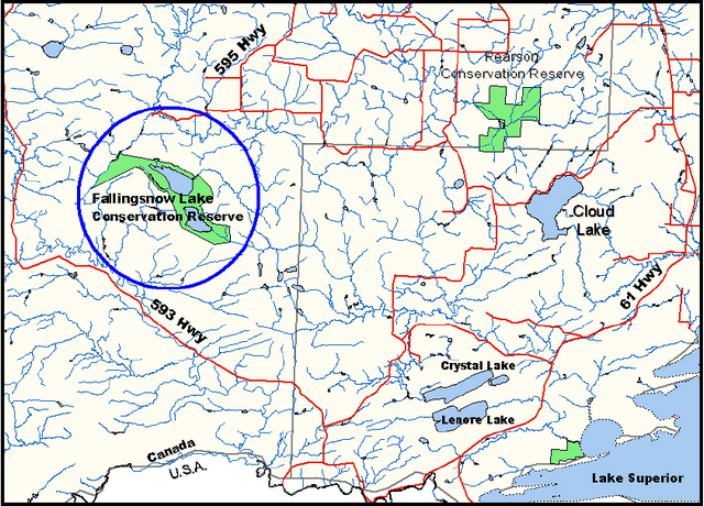
Enlarge Appendix A- Regional setting
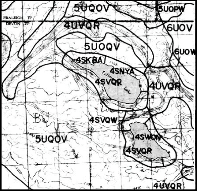
Appendix B- Conservation reserve map
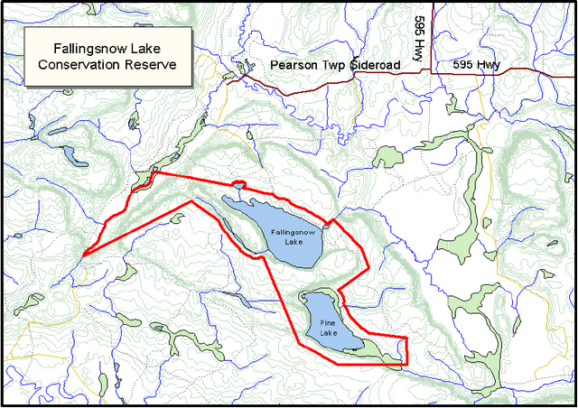
Enlarge Appendix B- Conservation reserve map
Appendix C - Photos
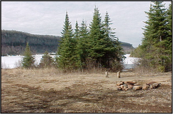
Campsite at Fallingsnow Lake
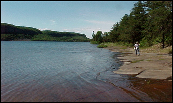
Fallingsnow Lake north shoreline
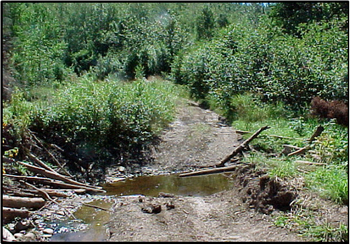
Road wash out at old road crossing
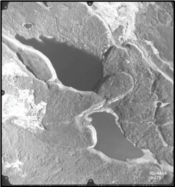
1992 Air Photo
Appendix D - Recreational Inventory Checksheet
Fallingsnow Lake Conservation Reserve (C2268)
Township: Devon Twp
Employee: Tracy Moore
Date: August 21st, 2000
Description of Site:
This recreational inventory is for Fallingsnow Conservation Reserve in Devon township. The conservation reserve is approximately 879 ha, and is located within the Great Lakes – St. Lawrence Forest Region, site district 4W-2 (Hills, 1997) .
The site is primarily dry, lying in an area of high local relief. The dominant landform is plain and terraced bedrock plateau (Mollard, NOEGTS 1979). The predominant cuesta topography contributes to the scenic beauty of the area.
For more information on the earth and life science features represented at Fallingsnow Lake Conservation Reserve see the report prepared by Geowest Environmental Consultants Ltd.
Methodology:
This inventory was compiled with the use of aerial photos, maps, area reports (values information, FRI, fisheries information) and two site visits.
Field Notes:
Two field visits were conducted by vehicle to examine the status of access trails. Old logging roads give access to a trail on the North side of Fallingsnow Lake where a collapsed beaver dam limits vehicle access at a point approximately 2 km from the reserve boundary. The trail continues within the boundaries of the conservation reserve for approximately 500 m where it meets Fallingsnow Lake. The south boundary is also accessible via old logging roads, however there are no existing trails leading into the reserve. There was no evidence to suggest that users are accessing the reserve from this side (South).
Part 1 – Basic recreation opportunities
| Activity | Permitted? | Comments/Details |
|---|---|---|
| Backcountry camping | Yes | Presently there are no 'formally' mapped backcountry campsites, however a site visit revealed evidence of lakeside camping at the end of the existing trail (see photo #1). Further along the tertiary trail there is an additional site in an open meadow. |
| Canoeing | Yes | Both Fallingsnow and Pine Lake present opportunity for canoeing, however only Fallingsnow Lake has trail access. There are no navigable streams entering or exiting either lake. |
| Hiking | Yes | Opportunity exists for hiking along the existing trail, on the north side of Fallingsnow Lake. |
| Hunting | Yes | Opportunity exists for large game, upland species (grouse), and possibly waterfowl hunting. |
| Fishing – recreational | Yes | (from Fallingsnow Lake Fisheries File) In 1971 the fish present included lake trout, brook trout and white sucker. Fallingsnow Lake has been described as "productive and capable of supporting large populations of game fish such as lake trout and to a lesser extent brook trout". In 1993 whitefish were reported and in 1998 rock bass. Stocking History
|
| Lakes | Yes | % of Lakes Seen - 1 of 2 – Fallingsnow Pine Lake is at this time inaccessible by trail or boat. Air photo interpretation reveals that Pine Lake is much shallower than Fallingsnow Lake and that approximately 50% of the shoreline is lacustrine wetland. Fallingsnow Lake on the other hand is a cold water lake with possible opportunity for a lake trout fishery. It has an area of approximately 350 acres and a maximum depth of 107 feet. There are two small isolated un-named lakes south west of Fallingsnow Lake. They are at this time inaccessible. |
| Swimming opportunities | Yes | Fallingsnow Lake is a deep lake with shoreline access at the end of the existing trail. It is free of weeds (see photo #2). |
| Beaches | No | |
| Rapids/waterfalls | No |
Other recreational/scenic features:
| Activity | Permitted? | Comments/Details |
|---|---|---|
| Nature and Wildlife Viewing | Yes | Fallingsnow Lake area is popular for birding and banding by locals and tourists. There is a prominent diabase mesa, contributing to the scenic value of Fallingsnow Lake Conservation Reserve, and also making it good habitat for Peregrine nesting. The lakes and surrounding forests may also provide suitable habitat for such species as Bald Eagles and Osprey. |
Summary of Area Description and Land Use Intent provided in Appendix A of the Land Use Strategy, July 1999, with specific reference to recreation uses and features:
Area Description
This site contains representative landform and vegetation types, including mixed deciduous and conifer forest types on strongly broken ground moraine. Fallingsnow Lake is a lake trout lake and the Fallingsnow Lake area is popular for birding and banding by locals and tourists.
Land Use Intent
The Land Use Strategy, July 1999, does not provide a summary of Land Use Intent.
Recommendations
The 'Thunder Bay District Fisheries Management Plan 1988 – 2000', states that "management for inland lakes of lake trout populations is intended to allow stocks to rebuild and sustain themselves by means of habitat population and harvest control". It is thus recommended that further study of the existence and state of the lake trout fishery be undertaken in an effort to identify any concerns or possible harvest control measures which may be required to ensure the continuation of self-sustaining populations.
Summary of 'Canada Land Inventory – Land Capability for Recreation'
(From: A Ready Reference – Ontario Land Inventory; Jan. 1977; pg 39-52) Canada Land Inventory maps at scale 1:50,000 have a 3 unit code
- First figure is a capability class that ranges from 1-7 (very high to very low capability for outdoor recreation)
- Second Unit- 2 categories – shoreline (S) and upland (U)
- Third figure is a subclass code of a feature that provides opportunity for recreation. The first code denotes main feature based on intensity of use.
The CLI divides Fallingsnow Lake Conservation Reserve into several classified polygons, however they are all quite similar in their classification and subclasses. The area is mostly Class 4 with only a small portion of Class 5 (surrounding two very small lakes south of Fallingsnow Lake). Class 4 – Moderate capability for outdoor recreation, is defined as land having the natural capability to sustain moderate total annual use, based on dispersed activities. The subclass codes define the area as predominantly shoreline with a small portion of upland. The area within the boundary of Fallingsnow Lake Conservation Reserve is described as having; access to water for angling and boating (A)(Y), a small section suited to organized camping (K), land suited to recreational lodging (N), opportunity for viewing interesting rock formations (R), opportunity for viewing upland wildlife (O), opportunity for viewing wetland life (W), and topography or land water relationships that enhance opportunity for general outdoor recreation, such as hiking and nature study (Q).
Part 2 – Human influences
| Activity | Permitted? | Comments/Details |
|---|---|---|
| Established campsites | No | |
| Established canoe routes | No | |
| Portages | No | |
| Established hiking trails | Yes | # Trails - One Old logging roads give access to a trail on the North side of Fallingsnow Lake. A collapsed beaver dam (see photo #3) may limit vehicle access at a point approximately 2 km from the reserve boundary (an ATV would easily cross and some users are crossing with vehicles). With exception to the dam, the road is otherwise clear and leads directly to the shore of Fallingsnow Lake. Within the boundary of the reserve the trail (road) extends for approximately 500m where it meets Fallingsnow Lake. There is also a trail, that is somewhat difficult to locate, which extends a short distance further up the lakeshore. |
| Snowmobile trails | Yes | # Trails – Same as above The above trail is used for snowmobile access in winter. |
| ATV trails | Yes | # Trails – Same as above |
| Existing informal access points | Yes | # Access points – Two Old logging roads lead from Highway 595. The main access point is 4 x 4 accessible and is as described above under Established Hiking Trails- "Old logging roads give access to a trail on the North side of Fallingsnow Lake. A collapsed beaver dam (see photo #3) may limit vehicle access at a point approximately 2 km from the reserve boundary (an ATV would easily cross and some users are crossing with vehicles). With exception to the dam, the road is otherwise clear and leads directly to the shore of Fallingsnow Lake". It is also possible to reach the boundary of the reserve via old logging roads on the south side of Fallingsnow Lake. There is a prominent fork in the road just prior to the broken beaver dam at the first access point. Here you would travel along the west boundary and approach Fallingsnow from the south. The road requires a 4x4 vehicle. Foot access into the reserve at this point would be through dense brush and rugged terrain. |
| Existing formal access point (road & parking) | No | |
| Existing boat caches | No | |
| Hunt camp | No | |
| Trapping | Yes |
# Trap lines – Two |
| Trapper cabins | Yes | # Cabins - Two The two trap cabins that are located within the reserve belong to Trap Line TB73. Their location and condition was not ground-truthed during field visits. |
| Resort/lodge in CR | No | |
| Resort/lodge adjacent | No | |
| Outpost camp in CR | No | |
| Outpost camp adjacent | No | |
| Historic sites/structures | No | None are known to exist at this time. |
| Mining | No | There are no existing mining claims within Fallingsnow Lake Conservation Reserve. |
| Mining adjacent to CR | Yes | The conservation reserve boundary south of Pine Lake is defined by the north limit of mining claim #1232794. The mining claim is excluded from the site. |
| Current mining exploration | No | |
| Evidence past exploration | No | |
| Inholdings | No | |
| Transmission lines | No | |
| Rights-of-way | No | |
| Towers | No | |
| Wild Rice Harvesting | No | |
| Water Impoundment | No | |
| Roads | No | The trail to Fallingsnow Lake is shown as a secondary road on District maps. |
| Other human-made structures: | At this time there have not been any other human-made structures identified. |
* The above does not represent the final regulated boundary for Fallingsnow Lake CR.
Recommendations
"The North Central Lake Trout Initiative (OMNR, 1981) states that careful planning of access should be used to control development on lake trout lakes as part of their overall management". Dependant upon the results of lake trout data collection, planning of recreational usage should be guided by the lake trout objectives as outlined in the District Fisheries Plan. This may include the discouragement of new or additional lake access.
References
Department of Regional Economic Expansion, 1969. The Canada Land Inventory, Land Capability Classification for Outdoor Recreation. Ottawa, Report #6.
Mollard, D.G., 1979. Northern Ontario Engineering Geology Terrain Study, Data Base Map, Thunder Bay. Ontario Geological Survey, Map 5047
Natural Heritage Information Centre http://www.mnr.gov.on.ca/MNR/nhic/nhic.html
NHIC contains information on rare, threatened and endangered species and spaces in Ontario.
Ontario Ministry of Natural Resources, 1999. Ontario’s Living Legacy – Land Use Strategy. 136 p.
Ontario Ministry of Natural Resources, 1989. Thunder Bay District Fisheries Management Plan 1988 –2000. 104 pp.
Enlarge Fallingsnow Lake Conservation Reserve map
Appendix E – Earth Science Checksheet
(completed by Geowest Environmental Consultants Ltd.)
Earth Science Inventory Checklist
| Name | Fallingsnow Lake (C2268) |
|---|---|
| Map Name | Pigeon River |
| NTS No. | 52A04 |
| UTM Reference: | 5335000N 293000E |
| OBM No. |
|
| Latitude: | 48°08' |
| Longitude: | 89°46' |
| Elevation (max) | 570 m |
| Elevation (min) | 370 m |
| County: | District of Thunder Bay |
| Township: | Devon |
| Concession/Lot | N/A |
| Area | 879 ha |
| Ownership: | Crown |
| Air Photos: | |
| MNR Region: | Northwest |
| MNR District: | Thunder Bay |
| Park Zone: | Thunder Bay |
| Survey Type: | Reconnaissance |
Earth science features
The Fallingsnow Lake Conservation Reserve (C2268) is approximately 45 km southwest of the City of Thunder Bay, Ontario. It is a relatively small area (879 ha) and is comprised of cuesta-like topography with extensive vertical bedrock exposures. Both Fallingsnow and Pine lakes occur within the Conservation Reserve. Waters from each lake flow into the Pine River and eastward towards Pine Bay on Lake Superior.
The Fallingsnow Lake Conservation Reserve is found in the Animikie Basin of the Southern Structural Province (Ontario Geological Survey 1991a). Card et. al., (1993) refers to the Animikie Basin as the Port Arthur Homocline. The Southern Structural Province was formed as part of the Midcontinent Rift (1.11 to 1.09 billion years ago) and lies partly in Canada and extends into the Lake Superior district of the United States. Sutcliffe (1992) has stated that "data shows the Midcontinent Rift to be one of the largest examples of plateau volcanism on earth." It comprises Aphebian or younger sedimentary and volcanic rocks that lie unconformably on Archean rocks of the Superior Province. The Aphebian rocks have been intruded by basic rocks (Logan sills).
Ridges and cuestas produced by the underlying folded sequence of Proterozoic diabase sills and sedimentary rocks (Thurston 1991) characterize the Animikie Basin (Port Arthur Homocline). Proterozoic sedimentary rocks (Animikie Group) comprise a conformable sequence of chert, jasper, iron-formation, carbonate, interbedded carbonate and chert, argillite, and tuffs. These rocks were deposited in a shallow-water, near-shore environment during a time of relative tectonic stability. These rocks show little deformation and have a shallow southerly dip (Stockwell, et. al. 1968).
Geul (1968) has mapped the Fallingsnow Lake area, as being comprised of intrusive diabase dominated Logan sills overlying older Rove Formation bedrock. The Animikie Rove Formation is approximately 500 m thick (Sutcliffe 1992) and consists of quartzitic greywacke with interbedded shale and argillite and black pyritic shale and argellite. Pye and Fenwick (1965) define the Logan sills as consisting mainly of diabase, porphyritic diabase, and gabbro. Geul (1968) has also mapped two faults occurring immediately to the northeast of Fallingsnow Lake and a number of vertical joints east of Pine Lake. This mapping is supported by Card et. al. (1993), Ontario Geological Survey (1991b), and Pye and Fenwick (1965). Figure 1 illustrates the overall bedrock of the area while Figure 2 provides a cross sectional diagram across Fallingsnow Lake.
Barnett (1992) suggests that Laurentide ice covered the Fallingsnow Lake area between 18 thousand years before present (ka BP) and ~ 9.8 ka BP. This coincides with the Late Wisconsinan Nissouri Stade (18 ka BP) and the beginning of the Holocene (~ 10 ka BP). Prest (1968) suggests that the area was ice-free as early as 11.5 ka BP, with surficial materials being from the North Bay Interstadial period (Davidson 1981; not recognised by Barnett). Zoltai (1963) has mapped glacial Lake O'Connor immediately to the north of the Fallingsnow Lake area. It is speculated here that glacial Lake O'Connor extended along the far-western end of the Conservation Reserve along the upper headwaters of Pine River. This hypothesis is supported by extensive organic-like terrain in the valley bottom.
The gap analysis suggests that a mix of moderately to strongly broken ground moraine characterize the Fallingsnow Lake Conservation Reserve. Mollard and Mollard (1983) have mapped the area, as being comprised bedrock plateaus (with high local relief), silty ground moraine with bedrock outcrops and organics. Zoltai (1965a) has mapped the area as clay to sandy ground moraine. No lacustrine deposits have been mapped.
The most prominent feature in the Conservation Reserve is the vertical bedrock exposures along Fallingsnow and Pine lakes. Along these exposures, diabase sheets (Logan sills) are underlain by Rove greywacke and interbedded shales. These vertical cliffs often exceed 100 m.
Generally, the morainal materials are less than 50 cm in thickness and consist of clay loams with up to 35 % subangular and subrounded coarse fragments. These materials are well to moderately well drained. Thicker till overlies strongly sloping bedrock in the far-western portion of the Conservation Reserve.
Imperfectly to poorly drained lacustrine materials are thought to occur within the upper Pine River watershed along the western boundary of the Conservation Reserve (~ 370 - 400 m). These sediments are speculated to be from glacial Lake O'Connor and because of their location relative to the central portion of the lake (varved clays), it is assumed that the materials are moderately coarse textured (i.e., sandy loams, loamy sands).
Talus deposits are common along the base of the vertical bedrock cliffs. They tend to be comprised of bedrock blocks and generally have a slope of < 45 %. They are rapidly drained with very little soil development.
Thick, poorly to very poorly drained organic and fluvial lacustrine deposits are typical around Pine Lake. These deposits/accumulations are thick (> 1 m) and prohibited any landing with a helicopter.
Sensitivity
Access to the Fallingsnow Lake Conservation Reserve is very limited. A trail from the north provides access to Fallingsnow Lake, only. It appears that individuals from the Thunder Bay area use this trail heavily for recreational purposes. According to the OLL Land Use Strategy July 1999, the area is "popular for birding and banding by locals and tourists" and is a sport fishing lake. Pine Lake is not accessible.
The clay loam nature of the morainal materials makes the trail susceptible to soil compaction and rutting. This is not expected to be a major problem however, as bedrock is generally encountered within 50 cm of the surface. The organic fluvial lacustrine sediments adjacent to Pine Lake and occurring in Pine River are very susceptible to disturbance. These materials are poorly to very poorly drained and should be avoided.
Recommendations
The Fallingsnow Lake Conservation has been recognised as having "representative landform and vegetation types, including mixed deciduous and conifer forest types on strongly broken ground moraine" (OLL 1999). While ground moraine is not a significant component of this site, the area should be protected as a Conservation Reserve as it provides an excellent example of the cuesta topography associated with the Animikie Basin (Port Arthur Homocline) of the Southern Structural Province. As noted above, the most significant feature of this Conservation Reserve are the vertical bedrock cliffs comprised of intrusive diabase dominated Logan sills overlying older Rove Formation bedrock.
Appendix F – Life Science Checksheet
(completed by Geowest Environmental Consultants Ltd)
| Name | Fallingsnow Lake Conservation Reserve (C2268) |
| Map Name | Pigeon River |
| Map Number | 52A4 |
| UTM Reference | 5335000N 293000E |
| County: | District of Thunder Bay |
| Latitude: | 48°08' |
| Longitude: | 89°46' |
| NAD | 27 |
| Minimum Altitude | 370 m |
| Maximum Altitude | 570 m |
| Locality | Thunder Bay |
| Township: | Devon |
| Area | 879 ha |
| Ownership: | Crown |
| MNR Region: | Northwest |
| Ecoregion and Ecodistrict | 4W-2 |
| Landform Unit(s) | Moderately to Strongly Broken Ground Moraine; Mesa-Cuesta Landforms |
| MNR District: | Thunder Bay |
| Aerial Photographs | Year 92-Roll 4805-Flight Line 19-Numbers 170-174 |
Physical and biological features
Representation
The Fallingsnow Lake Conservation Reserve (C2268) is located approximately 45 km southwest of the City of Thunder Bay, Ontario. It is a relatively small site (879 ha) and is characterized by mesa-cuesta topography with extensive vertical bedrock exposures and moderately undulating to strongly rolling uplands with mixedwood forests, and open wetlands in lower positions and along lakeshore margins. Both Fallingsnow and Pine lakes occur within the Conservation Reserve. Waters from both lakes flow into the Pine River and eastward into Pine Bay on Lake Superior.
The area is comprised of a diversity of upland forest and wetland vegetation types on a variety of landform types including till covered mesa and cuesta plateaus, bedrock escarpments, talus slopes, bare bedrock knolls, moderately to strongly broken morainal valley deposits, and organic accumulations of variable thickness.
Deciduous-dominated mixedwood forest dominates upland, well-drained sites with lesser amounts of coniferous-dominated mixedwood forest and patches of pure coniferous and deciduous forest communities. Deciduous stands and deciduous-dominated mixedwood stands are generally comprised primarily of either trembling aspen or white birch. Trembling aspen mixedwood stands (Vegetation Type V9 – Trembling Aspen Mixedwood; see Sims et. al. 1997) generally have a variable component of associated tree species such as white birch, white and black spruce, balsam fir, jack pine and white pine. The understory is generally shrub and herb rich, comprised of species such Corylus cornuta, Diervilla lonicera, Alnus crispa, Vaccinium myrtilloides, Rubus idaeus, Cornus canadensis, Aster macrophyllus, Lycopodium spp., Clintonia borealis, Pyrolla spp. and Calamagrostis canadensis. Moss cover is generally low with occasional patches of feathermosses such as Pleurozium schreberi and Ptilium crista-castrensis.
White birch dominated stands (Vegetation Type V4 – White Birch Hardwood and Mixedwood) also occur extensively in the area, particularly adjacent fluvial areas and along lakeshore margins, and in association with terrain dominated by bedrock overlain with thin morainal veneers. Canopy associates are white and black spruce and balsam fir. The understory cover is variable but is often dominated by species such as Corylus cornuta, Alnus crispa, Vaccinium spp., Diervilla lonicera, Cornus canadensis, Lycopodium spp., Clintonia borealis and Aster macrophyllus, as well as occasional patches of feathermoss.
Thin to moderately thick organic deposits occur to a limited extent in depressional sites overlying finer-textured lacustrine or fluvial deposits. These stands are generally dominated by black spruce with occasional occurrences of jack pine, balsam fir, tamarack and white birch (V33 – Black Spruce / Feathermoss, and Vegetation Type V36 – Black Spruce / Bunchberry / Sphagnum (Feathermoss)). Ericaceous species typically dominate the understory with a prevalence of Ledum groenlandicum, Vaccinium myrtilloides, and Gaultheria hispidula. Common herbaceous species, with generally lower cover, include Cornus canadensis, Lycopodium spp., Linnaea borealis and Carex spp. The forest floor is primarily covered by a continuous mat of feathermoss with patches, often extensive, of Sphagnum spp.
Open wetland sites (marshes and thicket swamps) with thin organic deposits also occur along lake margins, particularly in Pine Lake. Species composition is variable but may include a narrow band of scattered, stunted black spruce and tamarack and occasional white cedar, with typical shrub species such as Salix spp., Alnus rugosa and Cornus stolonifera. A band of emergent vegetation dominated by Carex spp., Scirpus spp. or occasionally Typha spp., occurs in shallow-water, sheltered areas.
Condition
This site is generally undisturbed except for a trail right-of-way that runs from the north to the north shore of Fallingsnow Lake. No road or trail access exists for Pine Lake. The site is a popular local backcountry camping, hiking and bird watching area and Fallingsnow Lake is a popular sport fishing lake, particularly for lake trout. Forest harvesting is relatively extensive in surrounding areas, but no logging is evident within the Conservation Reserve.
Diversity
A variety of landform/vegetation complexes occur within the Fallingsnow Lake Conservation Reserve. The most significant feature of the Conservation Reserve is the vertical bedrock cliffs associated with the mesa-cuesta plateaus that have developed on Proterozoic bedrock. Landform types associated with this terrain include thin till covered mesa-cuesta plateaus, escarpments, talus slopes, bare granitic knolls and slopes, and valley deposits of moderately to strongly broken ground moraine. Thick, poorly to very poorly drained organic and fluvial-lacustrine deposits are typical around Pine Lake.
Upland forests are comprised of a variety of deciduous, deciduous mixed, conifer and conifer mixed communities. Various wetland communities are also represented, varying from semi- treed and open fens to marsh and open-water marsh communities. Several small fluvial channels and small ponds are also present.
Ecological Considerations
Vegetation cover within the site is characteristic of the surrounding area and is predominantly fire-origin, mature mixedwood forest. Aspect, soil thickness and soil drainage tend to influence forest species composition, with coniferous-dominated stands being more prevalent on north aspects and poorer drained depressional areas and along lakeshore fringes, with deciduous-dominated stands occurring more commonly on southerly aspects and upper slopes. Forest stands tend to be fairly mature throughout the site, with few younger age classes represented. The site tends to be relatively undisturbed with no evidence of recent timber harvesting. A few patches of blowdown were observed to the south of Fallingsnow Lake.
The diversity of vegetation and forest cover types provide an equally diverse assemblage of wildlife habitats. Deciduous-dominated mixedwood stands provide excellent moose forage opportunities, while coniferous-dominated mixedwood and pure coniferous stands afford thermal habitats. The presence of ericaceous shrubs in the understory of mixedwood forest components also provides good habitat for black bear and smaller furbearers. OMNR records indicate that two registered traplines traverse the Fallingsnow Lake Conservation Reserve, on which beaver, mink, marten, otter, weasel and fisher were the reported catches. Browsing (by moose) was evident on aspen and birch trees and on alder and maple in the tall shrub layers. The steep bedrock cliffs adjacent to the site (near Lake Superior) are a component of Ontario’s successful peregrine falcon re-introduction. The lake itself is a cold-water lake, in which lake trout, speckled trout, white sucker, lake whitefish, and rock bass have been recorded.
The interspersion and juxtaposition of security, thermal, and foraging habitats for ungulates and furbearers is a key feature of this site. In addition, breeding bird diversity can be expected to be relatively high due to the diversity of habitats present.
The undulating and rolling topography also results in a few small ponds and poorly defined stream channels and wetlands in depressional areas and valley bottoms.
Special Features
No evidence of vulnerable threatened or endangered species, or "S" ranked species were encountered during the reconnaissance survey of the site. The steep bedrock cliffs could provide nesting and foraging habitat for peregrine falcons. Fallingsnow Lake is a locally popular lake trout sport fishery. Flat-lying bedrock resembling old pavement is found along the shoreline in several areas of Fallingsnow Lake.
Significance Level
Regionally Significant: The Fallingsnow Lake Conservation Reserve provides a good example of mature, deciduous-dominated mixedwood forest on till covered mesa-cuesta plateaus and moderately to strongly broken ground moraine. Steep bedrock escarpments, talus slopes and bedrock knolls also occur. It is representative of upland areas within Site District 4W-2.