False Rue-anemone Recovery Strategy
Read the recovery strategy for the False Rue-anemone, a plant species at risk in Ontario.
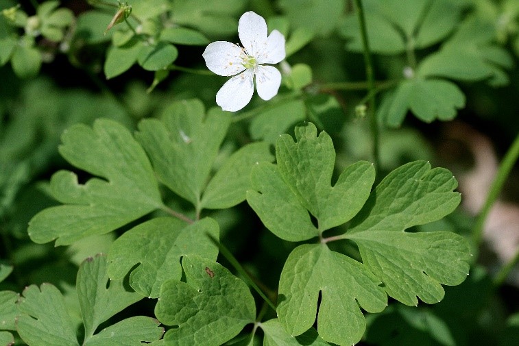
Cover photo by Sam Brinker
About the Ontario recovery strategy series
This series presents the collection of recovery strategies that are prepared or adopted as advice to the Province of Ontario on the recommended approach to recover species at risk. The Province ensures the preparation of recovery strategies to meet its commitments to recover species at risk under the Endangered Species Act, 2007 (ESA) and the Accord for the Protection of Species at Risk in Canada.
What is recovery?
Recovery of species at risk is the process by which the decline of an endangered, threatened, or extirpated species is arrested or reversed, and threats are removed or reduced to improve the likelihood of a species’ persistence in the wild.
What is a recovery strategy?
Under the ESA a recovery strategy provides the best available scientific knowledge on what is required to achieve recovery of a species. A recovery strategy outlines the habitat needs and the threats to the survival and recovery of the species. It also makes recommendations on the objectives for protection and recovery, the approaches to achieve those objectives, and the area that should be considered in the development of a habitat regulation. Sections 11 to 15 of the ESA outline the required content and timelines for developing recovery strategies published in this series.
Recovery strategies are required to be prepared for endangered and threatened species within one or two years respectively of the species being added to the Species at Risk in Ontario list. Recovery strategies are required to be prepared for extirpated species only if reintroduction is considered feasible.
What’s next?
Nine months after the completion of a recovery strategy a government response statement will be published which summarizes the actions that the Government of Ontario intends to take in response to the strategy. The implementation of recovery strategies depends on the continued cooperation and actions of government agencies, individuals, communities, land users, and conservationists.
For more information
To learn more about species at risk recovery in Ontario, please visit the Ministry of the Environment, Conservation and Parks Species at Risk webpage.
Recommended citation
Ministry of the Environment, Conservation and Parks. 2018. Recovery Strategy for the False Rue-anemone (Enemion biternatum) in Ontario. Ontario Recovery Strategy Series. Prepared by the Ministry of the Environment, Conservation and Parks, Peterborough, Ontario. iv + 6 pp. + Appendix. Adoption of the Recovery Strategy for False Rue-anemone (Enemion biternatum) in Canada (Environment Canada 2017).
© Queen’s Printer for Ontario, 2018
ISBN 978-1-4868-2772-5 (HTML)
ISBN 978-1-4868-2773-2 (PDF)
Content (excluding the cover illustration) may be used without permission with appropriate credit to the source, except where use of an image or other item is prohibited in the content use statement of the adopted federal recovery strategy.
Cette publication hautement spécialisée « Recovery strategies prepared under the Endangered Species Act, 2007 », n’est disponible qu’en anglais en vertu du Règlement 411/97 qui en exempte l’application de la Loi sur les services en français. Pour obtenir de l’aide en français, veuillez communiquer avec recovery.planning@ontario.ca.
Acknowledgments
The Ministry gratefully acknowledges Ian Jean (Forestry Specialist, Ausable Bayfield Conservation Authority) for information and insights regarding the recovery of False Rue-anemone in Ontario.
Declaration
The recovery strategy for the False Rue-anemone was developed in accordance with the requirements of the Endangered Species Act,2007 (ESA). This recovery strategy has been prepared as advice to the Government of Ontario, other responsible jurisdictions and the many different constituencies that may be involved in recovering the species.
The recovery strategy does not necessarily represent the views of all of the individuals who provided advice or contributed to its preparation, or the official positions of the organizations with which the individuals are associated.
The recommended goals, objectives and recovery approaches identified in the strategy are based on the best available knowledge and are subject to revision as new information becomes available. Implementation of this strategy is subject to appropriations, priorities and budgetary constraints of the participating jurisdictions and organizations.
Success in the recovery of this species depends on the commitment and cooperation of many different constituencies that will be involved in implementing the directions set out in this strategy.
Responsible jurisdictions
Ministry of the Environment, Conservation and Parks
Environment and Climate Change Canada – Canadian Wildlife Service, Ontario
Executive summary
The Endangered Species Act, 2007 (ESA) requires the Minister of the Environment, Conservation and Parks to ensure recovery strategies are prepared for all species listed as endangered or threatened on the Species at Risk in Ontario (SARO) List. Under the ESA, a recovery strategy may incorporate all or part of an existing plan that relates to the species.
The False Rue-anemone (Enemion biternatum) is listed as threatened on the SARO List. The species is also listed as threatened under the federal Species at Risk Act (SARA). Environment and Climate Change Canada prepared the Recovery Strategy for the False Rue-anemone (Enemion biternatum) in Canada in 2017 to meet its requirements under the SARA. This recovery strategy is hereby adopted under the ESA. With the additions indicated below, the enclosed strategy meets all of the content requirements outlined in the ESA.
Updated information is provided on the Parkhill Conservation Area Mud Creek population, including information on a previously unreported sub-population detected during the 2017 field season.
The Critical Habitat section of the federal recovery strategy provides an identification of critical habitat (as defined under the SARA). Identification of critical habitat is not a component of a recovery strategy prepared under the ESA. However, it is recommended that the approach used to identify critical habitat in the federal recovery strategy be considered, along with any new scientific information on False Rue-anemone and the areas it occupies, when developing a habitat regulation under the ESA.
Adoption of federal recovery strategy
The Endangered Species Act, 2007 (ESA) requires the Minister of the Environment, Conservation and Parks to ensure recovery strategies are prepared for all species listed as endangered or threatened on the Species at Risk in Ontario (SARO) List. Under the ESA, a recovery strategy may incorporate all or part of an existing plan that relates to the species.
The False Rue-anemone (Enemion biternatum) is listed as threatened on the SARO List. The species is also listed as threatened under the federal Species at Risk Act (SARA). Environment and Climate Change Canada prepared the Recovery Strategy for the False Rue-anemone (Enemion biternatum) in Canada in 2017 to meet its requirements under the SARA. This recovery strategy is hereby adopted under the ESA. With the additions indicated below, the enclosed strategy meets all of the content requirements outlined in the ESA.
Species assessment and classification
| Assessment | Status |
|---|---|
| SARO List classification | Threatened |
| SARO List history | Special Concern (2005) |
| COSEWIC assessment history | Threatened (2005), Special Concern (1990) |
| SARA schedule 1 | Threatened |
| Conservation status rankings | GRANK: G5 NRANK: N2 SRANK: S2 |
Distribution, abundance and population trends
The population of False Rue-anemone at Parkhill Conservation Area was reconfirmed extant as of June 2017 and a new sub-population was discovered within the element occurrence (I. Jean pers. comm. 2018). Accordingly, in Table 1 of the Recovery Strategy for the False Rue-anemone (Enemion biternatum) in Canada, the year of last observation for this population is considered to be 2017 rather than 2010. The abundance estimate has not changed since stems were not enumerated in June 2017.
Habitat needs
Available information indicates that False Rue-anemone is often found in Sugar Maple-dominated deciduous forest; however, this is not always the case. During the 2017 field season, False Rue-anemone was reconfirmed at the Parkhill Conservation Area intermittently distributed throughout an area of mixed deciduous forest. A separate sub-population was also discovered in early successional deciduous forest with Eastern Hop-hornbeam (Ostrya virginiana) and Ash (Fraxinus spp.) dominating the overstory. The description of this forest does not appear to fit within the vegetation types in association with which False Rue-anemone has been reported previously.
Recovery actions completed or underway
Staff at the Ausable Bayfield Conservation Authority (ABCA) have completed surveys for False Rue-anemone on Parkhill Conservation Area lands. This work led to the discovery of a new sub-population within the Parkhill Conservation Area/Mud Creek Element Occurrence (I. Jean, pers. comm. 2018).
Area for consideration in developing a habitat regulation
Under the ESA, a recovery strategy must include a recommendation to the Minister of the Environment, Conservation and Parks on the area that should be considered in developing a habitat regulation. A habitat regulation is a legal instrument that prescribes an area that will be protected as the habitat of the species. The recommendation provided below will be one of many sources considered by the Minister, including information that may become newly available following completion of the recovery strategy, when developing the habitat regulation for this species.
The Critical Habitat section of the federal recovery strategy provides an identification of critical habitat (as defined under the SARA). Identification of critical habitat is not a component of a recovery strategy prepared under the ESA. However, it is recommended that the approach used to identify critical habitat in the federal recovery strategy be considered, along with any new scientific information on False Rue-anemone and the areas it occupies, such as the newly-discovered sub-population within the Parkhill Conservation Area lands, when developing a habitat regulation under the ESA.
Glossary
- Committee on the Status of Endangered Wildlife in Canada (COSEWIC):
- The committee established under section 14 of the Species at Risk Act that is responsible for assessing and classifying species at risk in Canada.
- Committee on the Status of Species at Risk in Ontario (COSSARO):
- The committee established under section 3 of the Endangered Species Act, 2007 that is responsible for assessing and classifying species at risk in Ontario.
- Conservation status rank:
A rank assigned to a species or ecological community that primarily conveys the degree of rarity of the species or community at the global (G), national (N) or subnational (S) level. These ranks, termed G-rank, N-rank and S-rank, are not legal designations. Ranks are determined by NatureServe and, in the case of Ontario’s S-rank, by Ontario’s Natural Heritage Information Centre. The conservation status of a species or ecosystem is designated by a number from 1 to 5, preceded by the letter G, N or S reflecting the appropriate geographic scale of the assessment. The numbers mean the following:
- 1 = critically imperilled
- 2 = imperilled
- 3 = vulnerable
- 4 = apparently secure
- 5 = secure
- NR = not yet ranked
- Element occurrence:
- The basic unit of record for documenting and delimiting the presence and extent of a species on the landscape. It is an area of land and/or water where a species is, or was, present, and which has practical conservation value.
- Endangered Species Act, 2007 (ESA):
- The provincial legislation that provides protection to species at risk in Ontario.
- Species at Risk Act (SARA):
- The federal legislation that provides protection to species at risk in Canada. This act establishes Schedule 1 as the legal list of wildlife species at risk. Schedules 2 and 3 contain lists of species that at the time the Act came into force needed to be reassessed. After species on Schedule 2 and 3 are reassessed and found to be at risk, they undergo the SARA listing process to be included in Schedule 1.
- Species at Risk in Ontario (SARO) List:
- The regulation made under section 7 of the Endangered Species Act, 2007 that provides the official status classification of species at risk in Ontario. This list was first published in 2004 as a policy and became a regulation in 2008.
List of abbreviations
- COSEWIC:
- Committee on the Status of Endangered Wildlife in Canada
- COSSARO:
- Committee on the Status of Species at Risk in Ontario
- CWS:
- Canadian Wildlife Service
- ELC:
- Ontario Ecological Land Classification
- ESA:
- Ontario’s Endangered Species Act, 2007
- ISBN:
- International Standard Book Number
- SARA:
- Canada’s Species at Risk Act
- SARO:
- Species at Risk in Ontario
References
Jean, I., pers. comm. 2018. Personal communication to Eric Snyder. February 2018. Forestry Specialist, Ausable Bayfield Conservation Authority, Exeter, Ontario.
Appendix 1. Recovery strategy for the False Rue-Anemone (Enemion biternatum) in Canada
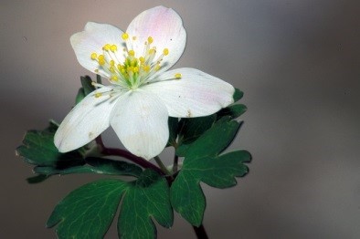
Federal cover illustration: Thomas G. Barnes @ USDA-NRCS plants Database
Document information
Recommended citation
Environment and Climate Change Canada. 2017. Recovery Strategy for the False Rue anemone (Enemion biternatum) in Canada. Species at Risk Act Recovery Strategy Series. Environment and Climate Change Canada, Ottawa. vii + 27 pp.
Other document information
For copies of the recovery strategy, or for additional information on species at risk, including the Committee on the Status of Endangered Wildlife in Canada (COSEWIC) Status Reports, residence descriptions, action plans, and other related recovery documents, please visit the Species at Risk (SAR) Public Registry.
Également disponible en français sous le titre « Programme de rétablissement de l’isopyre à feuilles biternées (Enemion biternatum) au Canada »
© Her Majesty the Queen in Right of Canada, represented by the Minister of Environment and Climate Change, 2017. All rights reserved.
ISBN 978-0-660-24437-2
Catalogue no. En3-4/284-2018E-PDF
Content (excluding the illustrations) may be used without permission, with appropriate credit to the source.
Preface
The federal, provincial, and territorial government signatories under the Accord for the Protection of Species at Risk (1996)
The Minister of Environment and Climate Change is the competent minister under SARA for the False Rue-anemone and has prepared this recovery strategy, as per section 37 of SARA. To the extent possible, it has been prepared in cooperation with the Ontario Ministry of Natural Resources and Forestry, as per section 39(1) of SARA.
Success in the recovery of this species depends on the commitment and cooperation of many different constituencies that will be involved in implementing the directions set out in this strategy and will not be achieved by Environment and Climate Change Canada, or any other jurisdiction alone. All Canadians are invited to join in supporting and implementing this strategy for the benefit of the False Rue-anemone and Canadian society as a whole.
This recovery strategy will be followed by one or more action plans that will provide information on recovery measures to be taken by Environment and Climate Change Canada and other jurisdictions and/or organizations involved in the conservation of the species. Implementation of this strategy is subject to appropriations, priorities, and budgetary constraints of the participating jurisdictions and organizations.
The recovery strategy sets the strategic direction to arrest or reverse the decline of the species, including identification of critical habitat to the extent possible. It provides all Canadians with information to help take action on species conservation. When critical habitat is identified, either in a recovery strategy or an action plan, SARA requires that critical habitat then be protected.
In the case of critical habitat identified for terrestrial species including migratory birds SARA requires that critical habitat identified in a federally protected area
For critical habitat located on other federal lands, the competent minister must either make a statement on existing legal protection or make an order so that the prohibition against destruction of critical habitat applies.
If the critical habitat for a migratory bird is not within a federal protected area and is not on federal land, within the exclusive economic zone or on the continental shelf of Canada, the prohibition against destruction can only apply to those portions of the critical habitat that are habitat to which the Migratory Birds Convention Act, 1994 applies as per SARA ss. 58(5.1) and ss. 58(5.2).
For any part of critical habitat located on non-federal lands, if the competent minister forms the opinion that any portion of critical habitat is not protected by provisions in or measures under SARA or other Acts of Parliament, or the laws of the province or territory, SARA requires that the Minister recommend that the Governor in Council make an order to prohibit destruction of critical habitat. The discretion to protect critical habitat on non-federal lands that is not otherwise protected rests with the Governor in Council.
Acknowledgments
The initial draft of this recovery strategy was completed by Holly Bickerton, Consulting Ecologist. Subsequent drafts were developed by Lee Voisin and Marie-Claude Archambault (Environment and Climate Change Canada, Canadian Wildlife Service – Ontario). Many thanks to the following people, who took the time to provide current information on False Rue-anemone, and greatly improved the information available: Ian Jean (Ausable Bayfield Conservation Authority), Cathy Quinlan and Brandon Williamson (Upper Thames River Conservation Authority), Linda McDougall (City of London), Jennifer Petruniak (Dillon Consulting Ltd.), and Daria Koscinski (Thames Talbot Land Trust). Rob Craig, Mike Oldham, Kathleen Pitt, Tanya Taylor (Ontario Natural Heritage Information Centre) and Krista Holmes (Environment and Climate Change Canada, Canadian Wildlife Service - Ontario) provided spatial data and additional support. This federal recovery strategy benefited from input, review and suggestions from the following individuals and organizations: Angela Darwin, Angela McConnell, Judith Girard, Ken Corcoran, and Elizabeth Rezek (Environment and Climate Change Canada, Canadian Wildlife Service – Ontario), Clint Jacobs (Walpole Island Heritage Centre) and Jay Fitzsimmons, Kristina Hubert, Mark Hulsman, Mike Oldham and Glenn Desy (Ontario Ministry of Natural Resources and Forestry).
Acknowledgement and thanks is given to all other parties that provided advice and input used to help inform the development of this recovery strategy including various Indigenous organizations and individuals, landowners, citizens, and stakeholders who provided input and/or participated in consultation meetings.
Executive summary
False Rue-anemone (Enemion biternatum) is listed as Threatened on Schedule 1 of the federal Species at Risk Act (SARA). It is a delicate spring plant in the buttercup (Ranunculaceae) family, which blooms in early spring. In Canada, False Rue-anemone occurs only in southwestern Ontario, within the Carolinian zone. There have been nine populations documented in Canada, of which five are considered extant. Ontario’s Natural Heritage Information Centre (NHIC) has recently reassessed occurrence ranks for this species using Nature Serve’s ranking approach. This reassessment resulted in several changes to occurrence ranks compared to the most recent status report from the Committee on the Status of Endangered Wildlife in Canada (COSEWIC). One very old population which has not been observed since 1897, was ranked extirpated by COSEWIC but reassessed as historic by NHIC based on availability of suitable habitat. Another population, presumed extirpated in the most recent COSEWIC report, was verified extant following a recent survey where the presence of False Rue-anemone was confirmed at this location. Occurrence reassessments by the NHIC also revealed a previously overlooked historic record, last observed in 1994 and unreported by COSEWIC, increasing the number of known populations to nine in this recovery strategy. Several of the extant populations are made up of many sub-populations. False Rue-anemone often produces many dense stems in large sub-populations; in 2005, the total Canadian population was estimated at one million stems. It is estimated that less than 1% of the species’ global range occurs in Canada.
Throughout its range, False Rue-anemone is found in mature, deciduous forests, often dominated by maple and beech. At Ontario sites, it generally occurs in deciduous forests dominated by Sugar Maple (Acer saccharum) with a variety of other canopy associates, and has been found in at least seven different vegetation community types. Most Ontario occurrences are along floodplains of rivers or creeks. The main threats to False Rue-anemone are invasive species, off-trail recreation and trail use and land development. Several other potential threats exist, including: global reduction of pollinators, erosion, habitat successional change, road salting, wildflower picking, mowing, and herbicide spraying.
Recovery for False Rue-anemone is considered feasible. The population and distribution objective is: To maintain the distribution, and maintain or increase the abundance of stems at extant populations and any re-confirmed historic populations in Canada.
Critical habitat for False Rue-anemone is partially identified in this recovery strategy, based on the best available data. A schedule of studies has been developed to assist in the future identification of critical habitat. As more information becomes available, additional critical habitat may be identified where sites meet the critical habitat criteria. Broad strategies to be taken to address the threats to the survival and recovery of this species are presented in the appropriate sections.
One or more action plans will be posted on the Species at Risk Public Registry for False Rue-anemone by 2023.
Recovery feasibility summary
Based on the following four criteria that Environment and Climate Change Canada uses to establish recovery feasibility, the recovery of the False Rue-anemone has been deemed technically and biologically feasible.
- Individuals of the wildlife species that are capable of reproduction are available now or in the foreseeable future to sustain the population or improve its abundance.
Yes. There are currently five extant populations of False Rue-anemone in Canada according to the NHIC, and some of these contain several sub-populations. The total number of stems is estimated at about one million (COSEWIC 2005). Canadian populations produce both flowers and seed, which could presumably be available to improve the population abundance, if required. This species is also widespread across the central-eastern United States, and is relatively common in the core of its range (NatureServe 2015). - Sufficient suitable habitat is available to support the species or could be made available through habitat management or restoration.
Yes. Although it is less common than before European settlement (COSEWIC 2005), sufficient suitable habitat is available to support the recovery of this species. Four populations recently identified as historic by the NHIC likely still possess significant suitable habitat and further increase the amount of suitable habitat known to be available to support the species. False Rue-anemone prefers mature deciduous forests and is often found in rich floodplains. It can occur in a variety of deciduous forest vegetation types, and is not considered highly specialized. - The primary threats to the species or its habitat (including threats outside Canada) can be avoided or mitigated.
Yes. The primary threats to the False Rue-anemone are competition from invasive plants, and soil compaction caused by off-trail recreational use. Garlic Mustard (Alliaria petiolata) has been present at low densities in some occupied habitats for over 25 years (Austen 1990; I. Jean, pers.comm. 2015), although it has not yet dominated any of these habitats. Techniques exist to control both Garlic Mustard and Goutweed (Aegopodium podagraria); Goutweed control has proven effective at one population (Dillon Consulting Ltd., 2015b). Soil compaction can be mitigated by education, signage, and controlling access where necessary. - Recovery techniques exist to achieve the population and distribution objectives or can be expected to be developed within a reasonable timeframe.
Yes. Invasive plant control is required to achieve the population and distribution objective, and successful control techniques are well known (OIPC 2015). An effective invasive species control program has been conducted at Medway Valley Heritage Forest (Dillon Consulting Ltd. 2014) and these efforts could be applied to other populations. False Rue-anemone is sometimes propagated in wildflower gardens in the central United States. However, propagation is likely unnecessary to achieve population and distribution objective.
1. COSEWIC (Committee on the Status of Endangered Wildlife in Canada) species assessment information
- Date of Assessment: May 2005
- Common Name (population): False Rue-anemone
- Scientific Name: Enemion biternatum
- COSEWIC Status: Threatened
- Reason for Designation: A delicate, spring-flowering, perennial herb restricted to a few fragmented riverside forest sites in southwestern Ontario where its populations are at risk from habitat loss and decline in quality due to a variety of activities including recreational trail use, and expansion of exotic invasive plants.
- Canadian Occurrence: Ontario
- COSEWIC Status History: Designated Special Concern in April 1990. Status re examined and designated Threatened in May 2005. Last assessment based on an updated status report.
2. Species status information
In Canada, the False Rue-anemone (Enemion biternatum) is listed as Threatened
The global conservation rank for the False Rue-anemone is Secure
It is estimated that less than 1% of the species’ global range occurs in Canada (Kartesz 2015).
3. Species information
3.1. Species description
False Rue-anemone is a delicate spring-flowering perennial
False Rue-anemone can be confused with the related Rue-anemone (Thalictrum thalictroides), which is found in drier habitats. Botanical keys, detailed descriptions, and technical illustrations can be found in Voss and Reznicek (2012), Reznicek et al. (2016), Gleason and Cronquist (1991), and Holmgren (1998).
3.2. Population and distribution
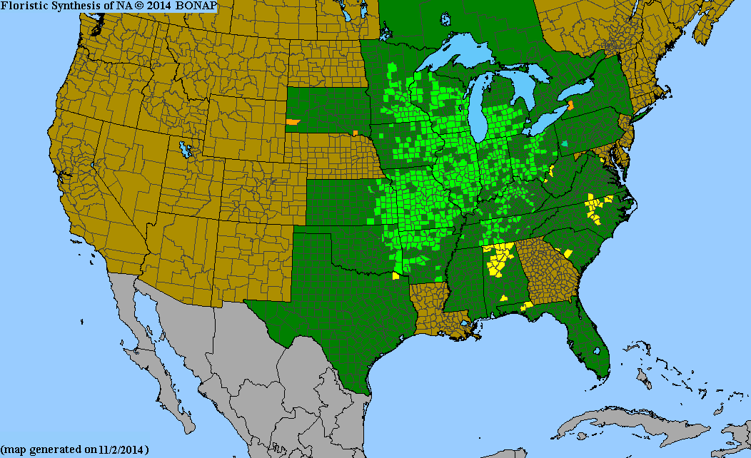
False Rue-anemone ranges across central-eastern North America. Its primary range extends from southwestern Ontario west to Illinois, south to Alabama and Georgia, and north along the western edge of the Appalachians through Tennessee and Kentucky. It is infrequently found east of the Appalachian Mountains (Boufford and Massey 1976; BONAP 2014).
Within Canada, the False-Rue anemone has been reported from nine populations, all in Ontario, within the Carolinian zone
According to latest occurrence ranking, there are five extant populations ranging from Port Stanley on Lake Erie, north to London, Ontario, and west to Lambton County. The remaining four populations are considered to be historic (NHIC 2016).
Two historic populations (Medway Creek, North of Arva and Thames River) have not been surveyed since 1994; however, significant suitable habitat exists in this area and it is likely that False Rue-anemone persists.
Occurrence reassessments by the NHIC also revealed a previously overlooked record, last observed in 1994 and unreported by COSEWIC. This East of Arva historic population was described to be in a habitat of “Moist Mesic open Bitternut Hickory mid‑aged tableland forest”. This population was not reported in COSEWIC 2005 or elsewhere, and has not been surveyed since, but likely suitable habitat and possibly False Rue-anemone persist.
A record reported from a herbarium specimen (Near Lynn Valley) was found further east of the extant range, near the Town of Simcoe in Norfolk County, and has not been observed since 1897. Although a recent survey (April 2016) did not find plants, significant suitable habitat was observed in the area. The NHIC has therefore assessed this population as historic whereas it had previously been identified as extirpated by COSEWIC.
In April 2016, a survey conducted by the NHIC rediscovered False Rue-anemone at the Middlemarch Forest Complex, increasing the number of extant populations from four to five. This population was classified as extirpated by COSEWIC (2005) and historic by the NHIC up until April 2016.
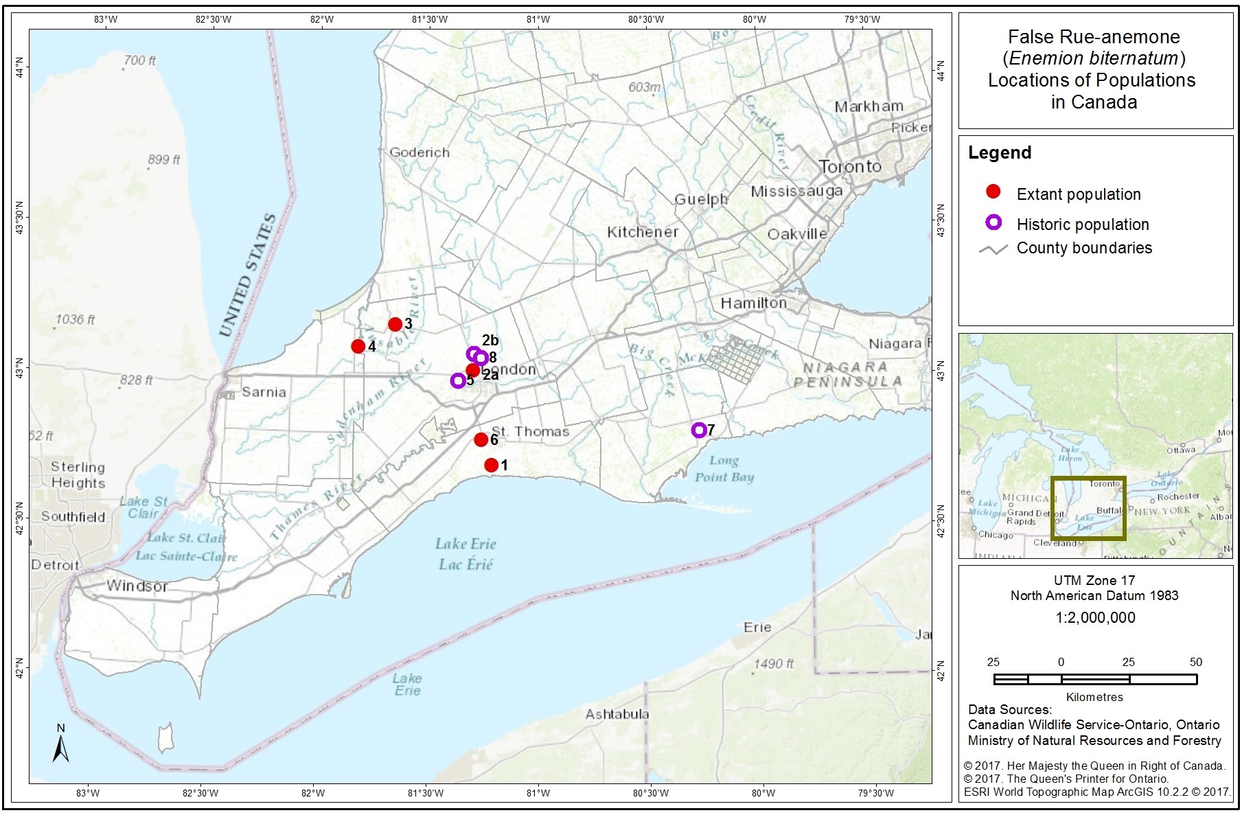
Figure 1. Distribution of the False Rue-anemone Populations in Canada.
| No. | Element Occurrence1 # | Population Name | Last Observed | Status2 | Abundance (total stems3, year observed) | Ownership (if known) |
|---|---|---|---|---|---|---|
| 1 | 2522 | Kettle Creek, North of Port Stanley | 2004 | Extant | ~113,000 (2004) | Probably private |
| 2a | 2523 | Medway Creek, London | 2015 | Extant | ~500,000 – 735,000 (2004) | University of Western Ontario, City of London; Huron College |
| 2b | 96274 | Medway Creek, North of Arva | 1994 | Historic | Unknown; “Species observed and collected” (1994) | Probably private |
| 3 | 2524 | Parkhill Conservation Area, Mud Creek | 2010 | Extant | ~400 plants (2004) | Ausable Bayfield Conservation Authority |
| 4 | 2525 | Ausable River | 2016 | Extant | 1000 (2004) | Thames Talbot Land Trust; Ausable Bayfield Conservation Authority |
| 5 | 13028 | Thames River | 1994 | Historic | Unknown | Unknown (probably private) |
| 6 | 115666 | Middlemarch Forest Complex | 2016 | Extant | Unknown | Unknown |
| 7 | 95609 | Near Lynn Valley | 1897 | Historic | Unknown | Unknown |
| 8 | 115 | East of Arva | 1994 | Historic | Unknown | Unknown (probably private) |
1The Element Occurrence (EO) is a data standard developed by NatureServe network scientists to improve the consistency and accuracy reporting plant and animal occurrences. For vascular plants, EOs are generally separate occurrences more than 1 km apart (NatureServe 2015). In the case of False Rue‑anemone, Element Occurrences may be equated to populations.
2As identified by the Ontario Natural Heritage Information Centre (NHIC) (2016) following the NatureServe EO definitions.
3The 1990 and 2005 COSEWIC status reports refer to “plants” and “stems” respectively, but all counts are based on stem counts (flowering and non-flowering).
The False Rue-anemone population in Canada, distributed among the populations with approximate abundance information, was estimated in 2005 at one million stems (COSEWIC 2005). Several of these populations consist of many sub-populations
The largest sub-populations of False Rue-anemone in Canada are found within the Medway Valley Heritage Forest in the City of London (Medway Creek, London, EO 2523), and on private lands along Kettle Creek (EO 2522). Together, these two EOs contain more than 80% of the known False Rue-anemone plants in Canada.
The extent of occurrence
Since the 2005 COSEWIC status report, at least three new sub-populations have been discovered during surveys on lands owned by the Ausable Bayfield Conservation Authority (ABCA 2010). These are considered part of the Ausable River population. Occurrence reassessments by the NHIC of False Rue-anemone records has identified a previously overlooked population East of Arva unreported by COSEWIC 2005. It is possible that other sub-populations of False Rue-anemone will continue to be discovered (or rediscovered) in the future. For example, the Parkhill population (EO #2524), thought to be extirpated, was rediscovered in 2002 (COSEWIC 2005), and a recent April 2016 survey by the NHIC has confirmed presence of the species at Middlemarch Forest Complex, which had been previously surveyed in 1981.
3.3. Needs of the False Rue-anemone
Throughout its range, False Rue-anemone is found in mature, deciduous forests, often dominated by maple and beech. At Ontario sites, it generally occurs in deciduous forests dominated by Sugar Maple (Acer saccharum), with a combination of several other overstory species, including (but not limited to): Hop-hornbeam (Ostrya virginiana), American Beech (Fagus grandifolia), hickory (Carya spp.), Basswood (Tilia americana), Butternut (Juglans cinerea) and ash (Fraxinus spp.; COSEWIC 2005). To date, vegetation communities have been identified using standard Ecological Land Classification (ELC; Lee et al. 1998) for several False Rue-anemone sub-populations within the Ausable River and Parkhill populations, and the Medway Creek, London (ABCA 2010; Dillon Consulting Ltd. 2015a). False Rue-anemone occurs in the following vegetation types in Canada:
- Dry-Fresh Sugar Maple Deciduous Forest (FOD5-1)
- Dry-Fresh Sugar Maple-Beech Deciduous Forest (FOD5-2)
- Fresh-Moist Lowland Deciduous Forest (FOD7)
- Fresh-Moist Ash Lowland Deciduous Forest (FOD7-2)
- Fresh-Moist Black Walnut Lowland Deciduous Forest (FOD 7-4)
- Fresh-Moist Black Maple Lowland Deciduous Forest (FOD7-5)
Within the Medway Creek, London, False Rue-anemone was also found within a vegetation community polygon broadly defined as Deciduous Swamp (SWD; Dillon Consulting Ltd. 2015a).
This is not a comprehensive list of vegetation communities in which False Rue‑anemone occurs, as many sub-populations have not yet been classified.
Based on fieldwork completed in 2003 and 2004, understory associates found with False Rue-anemone at two or more Ontario sub-populations include, but are not limited to, the following: Early Meadow-rue (Thalictrum dioicum), Starry False Solomon’s-seal (Maianthemum stellatum), False Solomon’s-seal (M. racemosum), Mayapple (Podophyllum peltatum), Blue Cohosh (Caulophyllum thalictroides), Jack-in-the-Pulpit (Arisaema triphyllum), White Trillium (Trillium grandiflorum), Red Trillium (T. erectum), Bloodroot (Sanguinaria canadensis), Spotted Geranium (Geranium maculatum), Yellow Trout-lily (Erythronium americanum), Cut-leaf Toothwort (Cardamine concatenata), Twinleaf (Jeffersonia diphylla), Wild Ginger (Asarum canadense), and violets (Viola spp.) (COSEWIC 2005). The non-native Garlic Mustard (Alliaria petiolata) and Goutweed (Aegopodium podagraria) are also present to dominant in the understorey at some sub-populations (Thompson 2004; I. Jean, pers. comm. 2015; B. Williamson, pers. comm. 2015).
False Rue-anemone is most commonly found in shaded sites, although it may occur in thickets (Baskin and Baskin 1986). It usually occurs in the rich alluvial soils of floodplains, although it can sometimes be found on adjacent wooded slopes. A study in Illinois found that a majority of clumps at one site occurred within 25 m of a stream (Melampy and Hayworth 1980). It also appears to prefer calcareous soils (Baskin and Baskin 1986). In Ontario, it is found in areas of grey brown luvisolic soils
This species generally occurs under mesic
Within its suitable habitat in Ontario and elsewhere, False Rue-anemone is characteristically found in dense sub-populations which are distributed in patches throughout suitable habitat (Thompson 2004; Schemske et al. 1978).
False Rue-anemone flowers are visited and pollinated by a wide variety of insects, including the European honey bee (Apis mellifera), parasitoid wasps, andrenid bees, halictid bees, syrphid flies, other flies, and beetles (Schemske et al. 1978; Melampy and Hayworth 1980; Tooker and Hanks 2000). Insect species associated with False Rue‑anemone can be found in Schemske et al. (1978), Tooker et al. (2006), and Graham et al. (2012). Wind also plays a minor role in pollination (Melampy and Hayworth 1980). However, like many other plants in the forest understory, False Rue‑anemone probably relies to a great extent on vegetative propogation, rather than on seed production by pollinators.
4. Threats
4.1. Threat Assessment
This section highlights the threats outlined in Table 2, emphasizes key points, and provides additional information. The threats are presented in decreasing order of level of concern within each category.
| Threat | Level of Concern1 | Extent | Occurrence | Frequency | Severity2 | Causal Certainty3 |
|---|---|---|---|---|---|---|
| Invasive Species: Invasive plants | Medium | Localized | Historic, Current, Anticipated | Continuous | Unknown | Medium |
| Disturbance or Harm: Off-trail Recreation and trail use | Medium | Localized | Current | Recurrent | Moderate | Medium |
| Habitat Loss or Degradation: Land development | Medium | Widespread | Anticipated | Unknown | Moderate | High |
| Habitat Loss or Degradation: Forest harvesting | Unknown | Unknown | Unknown | Unknown | Unknown | Unknown |
1Level of Concern: signifies that managing the threat is of (high, medium or low) concern for the recovery of the species, consistent with the population and distribution objectives. This criterion considers the assessment of all the information in the table.
2Severity: reflects the population-level effect (High: very large population-level effect, Moderate, Low, Unknown).
3Causal certainty: reflects the degree of evidence that is known for the threat (High: available evidence strongly links the threat to stresses on population viability; Medium: there is a correlation between the threat and population viability e.g. expert opinion; Low: the threat is assumed or plausible).
4.2. Description of threats
Invasive species
Invasive plants: Goutweed has been identified as a serious invasive threatening False Rue-anemone and other significant flora in the Medway Creek, London (COSEWIC 2005). Staff at the Upper Thames Region Conservation Authority are removing Goutweed within this area, and efforts to date have been extremely successful (Dillon Consulting Ltd. 2015b).
In fieldwork conducted in 2003 and 2004, Garlic Mustard was present at six sub‑populations within the Medway Creek area, and the Kettle Creek population (Thompson 2004; NHIC 2015). It is also present at most of the sub-populations within the Ausable River and Parkhill populations (I. Jean, pers. comm. 2015). Garlic Mustard is probably a minor to moderate threat at the sites where False Rue-anemone has been recently observed. However, it is a persistent threat throughout southern Canada (Catling et al. 2015). It has been co-occurring with False Rue-anemone for many years, and may not be outcompeting the native flora (Austen 1990; I. Jean, pers. comm. 2015). However, many sub-populations have not been visited in over a decade.
Disturbance or harm
Off-trail Recreation and trail use: ATV use is a localized threat to certain populations and habitat. For example, unauthorized ATV traffic follows the Ausable River through a few False Rue-anemone sub-populations, and is difficult to control (I. Jean, pers. comm. 2015). Some False Rue-anemone sub-populations are also in close proximity to public areas and trails, and may be threatened to some degree by inadvertent trampling, and resulting soil compaction (Austen 1990; COSEWIC 2005). However, improving signage at walking trails in Medway Creek, London have also helped to limit trampling and promote public awareness of this species (J. Petruniak, L. McDougall, pers.comm. 2015). In 2004, camping was observed near one of the Kettle Creek sub-populations (COSEWIC 2005), but it is not known whether this still occurs, or how frequently.
Habitat loss or degradation
Land development: The destruction of False Rue-anemone habitat through development or vegetation clearance is possible, since two of five extant populations are privately owned and located in areas where land development is increasing. Sites along floodplains and slopes on private lands are likely protected to some degree due to corresponding development restrictions, and habitat clearance is probably not a major threat. Although, sites with large sub-populations can still occupy very little space, and at least one population with a very large abundance (113,000 stems) is probably entirely privately owned.
Forest harvesting: Recent status reports (Austen 1990 and COSEWIC 2005) consider at least two populations on private lands to be threatened by wood cutting operations. The scale and status of this threat is currently unknown, and is considered a knowledge gap. Because False Rue-anemone prefers shaded, mature forests of high quality, selective logging could affect populations by increasing light levels to the extent that habitat is unsuitable, or plants are outcompeted by other species.
Other potential threats
There are several potential threats that are believed to impact the False Rue-anemone in Canada, although more information is needed to assign a level of concern. Severe declines of many pollinators are being observed across North America and globally (Potts et al. 2010). It is possible that this may present a threat to the False Rue‑anemone, which is mainly insect-pollinated, although not enough is known about the potential impacts. False Rue-anemone is found in only a few, widespread locations in southwestern Ontario, and this fragmented distribution, especially if combined with increased self-pollination caused by pollinator declines, could lead to genetic inbreeding, or a reduction in reproductive success (Thomann et al. 2013).
It is possible that disease and pests affecting common canopy trees may change light and/or moisture levels in some forests where the False Rue-anemone occurs. Emerald Ash Borer (Agrilus planipennis) has virtually eliminated the ash canopy across most of southwestern Ontario, and in some floodplain areas, ash was previously a dominant species. The resultant increase in light penetration can change the composition of the forest understory, as other species become more competitive (H. Bickerton, pers. obs. 2015). Butternut canker (Sirococcus clavigignenti-juglandacearum) and Beech Bark Disease also cause defoliation of the forest canopy, although to a lesser degree within False Rue-anemone habitat. The extent and severity of this threat is unclear, since many sites have not been visited in over a decade.
Several other potential threats are mentioned in the 2005 and 1990 COSEWIC status reports for this species, including erosion, habitat successional change, road salting, wildflower picking, mowing, and herbicide spraying. The current status of these threats is unknown.
5. Population and distribution objectives
The population and distribution objective for the False Rue-anemone in Canada is:
To maintain the distribution, and maintain or increase the abundance of stems at extant populations and any re-confirmed historic populations in Canada.
False Rue-anemone is naturally uncommon in Canada, where it occurs along the northern limit of its range. There are currently five known extant populations of False Rue-anemone in Canada that are to be maintained under the population and distribution objective. The approach is to encourage the natural increase of extant populations through the reduction or elimination of threats from invasive species, trampling and/or soil compaction, protection of habitat and public education. As noted in COSEWIC (2005), the Canadian population of False Rue-anemone is estimated to be around one million stems within the current populations (Table 1). The distribution of the NHIC’s Element Occurrences can be measured by the Extent of Occurrence of around 1000 km2. It is recognized that stem counts for this species may fluctuate and may not currently be an adequate measure of abundance. Development of an appropriate survey protocol to monitor fluctuations in abundance and distribution is vital to understand trends of this species in Canada. Until more research is conducted, the estimated Area of Occupancy of 20 km2 will be maintained. This species is naturally uncommon in Ontario, and therefore will likely continue to have a relatively small distribution. Maintaining the distribution of all extant populations for False Rue-anemone throughout Ontario is imperative for the recovery of this species. Maintaining any additional populations that may be re‑confirmed at historic sites will also be important to the objective.In addition to measuring progress towards the population and distribution objective, a regular assessment of threats will be important in evaluating the recovery of this species.
6. Broad strategies and general approaches to meet objectives
6.1. Actions already completed or currently underway
False Rue-anemone is listed under the ESA as Threatened and its general habitat is protected under the Ontario Endangered Species Act, 2007.
Since the COSEWIC status report publication in 2005, monitoring and habitat management activities have occurred at a number of sites as described below.
Staff at the Ausable Bayfield Conservation Authority (ABCA) have completed surveys for False Rue-anemone on Conservation Authority lands within the Ausable River floodplain (ABCA 2010). This work led to the discovery of three new sub-populations within the Ausable River EO, and it is possible that more will be discovered during future surveys in the area. The ABCA aims to continue to monitor and map known occurrences on its lands every five to ten years. Surveys are planned for 2016 (I. Jean, pers. comm. 2015).
In 2014, the City of London retained Dillon Consulting Ltd. to develop a False Rue‑anemone Mitigation Plan (Dillon Consulting Ltd. 2014), which outlines a management plan to control Goutweed in the vicinity of this threatened species. Subsequently, the Upper Thames River Conservation Authority and the City of London initiated Goutweed control at several sites in Medway Creek, London. This project has continued in 2015 and shows excellent results to date (B. Williamson, pers.comm. 2015; Dillon Consulting Ltd. 2015b).
The City of London has completed a Natural Heritage Inventory and Evaluation for the Medway Creek, London, including Ecological Land Classification and a floral inventory, improving knowledge of the species abundance, distribution, biology and threats in the area (Dillon Consulting Ltd. 2015a).
The Ontario Invasive Species Council has produced several gardening guides for Ontario. These guides, “Grow Me Instead”, include gardening best management practices and promote the use of native and non-invasive plants, while providing awareness about planting invasive and non-native plants (such as Goutweed). For more information, visit: “Grow Me Instead” guides.
6.2. Strategic direction for recovery
| Threat or Limitation | Prioritya | Broad Strategy to Recovery | General Description of Research and Management Approaches |
|---|---|---|---|
| All threats Knowledge gaps | High | Assess and monitor populations |
|
| Invasive species | High | Control invasive species |
|
| Off-trail Recreation and trail use | Medium | Protect and manage habitat |
|
| Habitat loss and degradation | Medium | Protect and manage habitat Outreach and stewardship |
|
a“Priority” reflects the degree to which the broad strategy contributes directly to the recovery of the species or is an essential precursor to an approach that contributes to the recovery of the species.
7. Critical habitat
7.1. Identification of the species’ critical habitat
Section 41(1)(c) of SARA requires that recovery strategies include an identification of the species’ critical habitat, to the extent possible, as well as examples of activities that are likely to result in its destruction. Under section 2(1) of SARA, critical habitat is “the habitat that is necessary for the survival or recovery of a listed wildlife species and that is identified as the species’ critical habitat in the recovery strategy or in an action plan for the species”.
This federal recovery strategy identifies critical habitat for False Rue-anemone in Canada to the extent possible, based on the best available information as of April 2016. It is recognized that the critical habitat identified below (see Figure 2 and Appendix C) is insufficient to achieve the population and distribution objective for the species. The Schedule of Studies (Table 4) outlines the activities required for identification of additional critical habitat necessary to support the population and distribution objective. Additional critical habitat may be added in the future, if new or additional information supports the inclusion of areas beyond those currently identified (e.g., new populations are found or rediscovered, or existing sub-populations expand into adjacent areas).
Critical habitat identification for False Rue-anemone is based on two criteria: habitat occupancy and habitat suitability.
7.2. Habitat occupancy
The habitat occupancy criterion refers to areas of suitable habitat where there is a reasonable degree of certainty of current use by the species.
Habitat is considered occupied when:
- At least one False Rue-anemone stem has been observed since 1995.
Habitat occupancy is based on occurrence reports available for populations from the NHIC and COSEWIC, as well as other project based data reports (ABCA 2010; Dillon 2015a). Within Canada, False Rue-anemone is reported from five extant populations that meet the occupancy criterion with significant suitable habitat. If new observations become available for the four historic populations, they will be considered for the identification of additional critical habitat, as these populations have not been reported since 1995 and do not meet the occupancy criterion.
7.3. Habitat suitability
Habitat suitability relates to areas possessing a specific set of biophysical attributes that can support individuals of the species in carrying out essential aspects of their life cycle. At persistent locations in Canada, the False Rue-anemone is typically found in deciduous forests dominated by Sugar Maple, in combination with several other overstorey species, including but not limited to: Hop-hornbeam, American Beech, Hickory, Basswood, Butternut and Ash (COSEWIC 2005).
The biophysical attributes, which capture the characteristics required by the species to carry out its life processes, include:
- Mature, mesic, shaded deciduous forests, dominated by Sugar Maple, such as deciduous floodplain forests and adjacent wooded slopes
- Grey brown luvisolic soils that are rich in calcareous till
Based on the best available information, suitable habitat for the False Rue-anemone is currently defined as the extent of the biophysical attributes at known extant populations. In addition, a critical function zone of 50 m (radial distance) is applied when the biophysical attributes around a stem extend for less than 50 m.
In Ontario, suitable habitat for the False Rue-anemone is best described using the Ecological Land Classification (ELC) framework for Southern Ontario (from Lee et al. 1998). The ELC framework provides a standardized approach to the interpretation and delineation of dynamic ecosystem boundaries. The ELC approach classifies habitats not only by vegetation community but also considers soil moisture conditions and topography, and as such encompasses the biophysical attributes of suitable habitat for False Rue-anemone. In addition, ELC terminology and methods are familiar to many land managers and conservation practitioners who have adopted this tool as the standard approach for Ontario.
Within the ELC system in Ontario, the ecosite boundary best captures the extent of biophysical attributes required by the species. The ecosite includes the areas occupied by the False Rue-anemone and the surrounding areas that provide suitable habitat conditions to carry out essential life process for the species and should allow for natural processes related to population dynamics and reproduction (e.g., dispersal and pollination) to occur. There is no specific information about seed dispersal, but the occupied ELC ecosite should provide sufficient opportunity for dispersal and expansion of populations (increase abundance of extant populations). This larger area around the plant may also promote ecosystem resilience to invasive species.
ELC ecosites (Lee et al. 1998) containing False Rue-anemone have been described as Dry-Fresh Sugar Maple Deciduous Forest (FOD5), and Fresh-Moist Lowland Deciduous Forest (FOD7)
The 50 m radial distance is considered a minimum ‘critical function zone’, or the threshold habitat fragment size required for maintaining constituent microhabitat properties for a species (e.g., critical light, temperature, litter moisture, humidity levels necessary for survival). At present, it is not clear at what exact distances physical and/or biological processes begin to negatively affect False Rue-anemone. Studies on micro‑environmental gradients at habitat edges, including light, temperature, litter moisture (Matlack 1993), and of edge effects on plants in mixed hardwood forests, as evidenced by changes in plant community structure and composition (Fraver 1994), have shown that edge effects could be detected up to 50 m into habitat fragments although other studies show that the magnitude and distance of edge effects will vary depending on the structure and composition of adjacent habitat types (Harper et al. 2005). Therefore, a 50 m radial distance from any False Rue-anemone stem was chosen to ensure that microhabitat properties were maintained as part of the identification of critical habitat. The area within the critical function zone may include both suitable and unsuitable habitat as False Rue-anemone may be found near a transition area/zone between suitable and unsuitable habitat. As new information on species’ habitat requirements and site-specific characteristics, such as hydrology, become available, these distances may be refined.
Human-made structures (e.g., maintained roadways, buildings) do not possess the biophysical attributes of suitable habitat or assist in the maintenance of natural processes and are not considered part of critical habitat.
7.4. Application of the criteria to identify critical habitat for False Rue-anemone
Critical habitat for the False Rue-anemone is identified as the extent of suitable habitat (section 7.1.2) where the habitat occupancy criteria is met (section 7.1.1). In cases where the suitable habitat extends for less than 50 m around a False Rue-anemone stem, a critical function zone capturing an area within a radial distance of 50 m is also included as critical habitat.
In Ontario, as noted above, suitable habitat for False Rue-anemone is most appropriately identified at the ecosite level. At the present time, ecosite boundaries are not available to support the identification of critical habitat for all populations in Ontario. In the interim, where ELC ecosite boundaries are not available, the ELC community series level is identified as the area within which critical habitat is found, as it will encompass the ecosite boundary around any False Rue-anemone stem, and the 50 m critical function zone. In Ontario, critical habitat is located within these boundaries where the biophysical attributes described in section 7.1.2 are found and where the occupancy criterion is met (section 7.1.1). When ecosite boundaries are determined, the identification of critical habitat will be updated.
Application of the critical habitat criteria above to the best available information identifies critical habitat for the five extant populations of False Rue-anemone in Canada (see Figure 2, Appendix B). The critical habitat identified in this recovery strategy is not considered a full identification of critical habitat and is insufficient to meet the population and distribution objective for False Rue-anemone. A schedule of studies (Table 4) has been prepared to identify critical habitat for populations where suitable habitat persists but do not currently meet the occupancy criterion. Additional critical habitat may be added in the future, if new or additional information supports the inclusion of areas beyond those currently identified (e.g., new sites become colonized, are rediscovered or existing sites expand into adjacent areas).
Critical habitat identified for False Rue-anemone is presented using 1 x 1 km standardized UTM grid squares. The UTM grid squares presented in Figure 2 are part of a standardized grid system that indicates the general geographic areas containing critical habitat, which can be used for land use planning and/or environmental assessment purposes. In addition to providing these benefits, the 1 x 1 km standardized UTM grid respects data-sharing agreements with the province of Ontario. Critical habitat within each grid square occurs where the description of habitat occupancy (section 7.1.1) and habitat suitability (section 7.1.2) are met. More detailed information on critical habitat to support protection of the species and its habitat may be requested on a need-to-know basis by contacting Environment and Climate Change Canada – Canadian Wildlife Service at ec.planificationduretablissement‑recoveryplanning.ec@canada.ca.
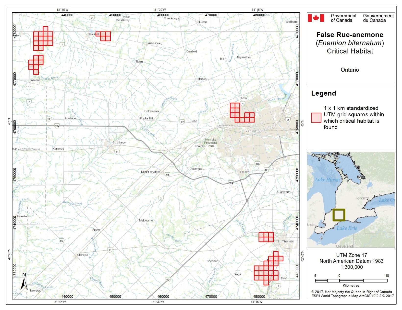
Figure 2. Grid squares that contain critical habitat for False Rue-anemone in Canada. Critical habitat for False Rue-anemone occurs within these 1 x1 km standardized UTM grid squares (red shaded squares), where the description of habitat suitability (section 7.1.2) and habitat occupancy (section 7.1.1) are met.
7.5. Schedule of studies to identify critical habitat
Four historic populations of False Rue-anemone (Thames River, Medway Creek, Lynn Valley and East of Arva) contain suitable habitat for the species; however, occupancy has not been confirmed at these populations since 1994 (See Table 1). The schedule of studies listed in Table 4 is designed to gather information required to fully identify critical habitat for the recovery of False Rue-anemone in Canada.
| Description of Activity | Rationale | Timeline |
|---|---|---|
| Survey historic sites with suitable habitat (Thames River, Medway Creek, Lynn Valley, and East of Arva) to determine if False Rue-anemone persists. | Surveys to confirm False Rue-anemone at these sites would contribute to a full identification of critical habitat of all current populations. Populations have been rediscovered in the past. | 2017-2022 |
7.6. Activities likely to result in the destruction of critical habitat
Understanding what constitutes destruction of critical habitat is necessary for the protection and management of critical habitat. Destruction is determined on a case by case basis. Destruction would result if part of the critical habitat was degraded, either permanently or temporarily, such that it would not serve its function when needed by the species. Destruction may result from a single activity or multiple activities at one point in time or from the cumulative effects of one or more activities over time. It should be noted that not all activities that occur in or near habitat are likely to cause its destruction.
Activities described in Table 5 include those likely to cause destruction of critical habitat for the species; however, destructive activities are not necessarily limited to those listed.
| Description of Activity | Description of effect in relation to function loss | Details of effect |
|---|---|---|
| Operation of motorized vehicles, such as ATVs, trucks, heavy equipment | Vehicle use can result in soil compaction which can reduce or eliminate germination of seeds and root growth is reduced or eliminated. It may also introduce invasive plant species by spreading seeds from nearby areas. Disturbing native ground cover can also increase ability of invasive plants to colonize areas. | When this activity occurs within critical habitat at any time of year, the effects would be direct and the activity is very likely to result in destruction or degradation of critical habitat because the species is dependent upon loose forest soils for germination. |
| Introduction of exotic species, especially plants or invertebrates (e.g. introduction of non-native plant seeds, plants, foreign soil or gravel, composting or dumping of garden waste, ATV use, livestock grazing) | Introducing invasive species can result in the False Rue-anemone being out competed by the invasive species, and/or physical and chemical changes to habitat such that it is no longer suitable for this species. | When this activity occurs within or adjacent to critical habitat, at any time of year, it can result in the introduction of invasive species that can lead to gradual destruction of critical habitat over time. |
| Any residential, agricultural, or industrial development such as construction of houses, structures, roads, gardens, quarries, utility lines, renewable energy installations, including removal of soils | Construction within critical habitat destroys habitat and results in the direct loss of critical habitat upon which the species relies for basic survival, successful seed germination, and seedling establishment. Direct removal of soil/substrate would render the habitat unsuitable for False Rue-anemone by removing the biophysical attributes required by the species. | When this activity occurs within critical habitat, at any time of year, the effects will be direct, and is certain to result in the permanent destruction of critical habitat. Activities restricted to the surface of existing, authorized roadways/access roads and recreational trails would not result in the destruction of critical habitat. |
| Removal of native vegetation component of critical habitat, including clear-cut and selective forest harvesting | Results in an increase in light penetration within the mature forest, reduction in soil moisture, reduction in summer air humidity, and an increase in the probability of propagules of invasive species being introduced on forestry equipment, and potentially in habitat no longer being suitable for the species. | When this activity occurs within critical habitat, it may result in its destruction. The effects may be direct (e.g. through habitat loss) or indirect (e.g. through increased competition by forest vegetation). |
8. Measuring progress
The performance indicators presented below provide a way to define and measure progress toward achieving the population and distribution objective
Every five years, success of recovery strategy implementation will be measured against the following performance indicators:
- There are at least five extant populations in Canada with a total abundance of 1 million stems or more.
9. Statement on action plans
One or more action plans for False Rue-anemone in Canada will be posted on the Species at Risk Public Registry by 2023.
10. References
Ausable Bayfield Conservation Authority (ABCA). 2010. Terrestrial Species at Risk on ABCA Lands: Results of 2008-2010 Field Surveys. Confidential Report. 20 pp.
Austen, M. J. W. 1990. Status Report on the false rue-anemone Isopyrum biternatum in Canada., COSEWIC, Ottawa, ON.
Baskin, J. M., and C. C. Baskin. 1986. Germination ecophysiology of the mesic deciduous forest herb Isopyrum biternatum. Botanical Gazette:152-155.
Bickerton, Holly. 2015. Personal Observation. Consultant. Ottawa, Ontario.
Biota of North America Program (BONAP). 2014. Floristic Synthesis of North America: Enemion biternatum. Web site. http://bonap.net/MapGallery/County/Enemion%20biternatum.png
Boufford, D., and J. Massey. 1976. Isopyrum biternatum (Raf.) T. & G.(Ranunculaceae) new to Virginia and its distribution east of the Appalachian mountains. Rhodora 78:790-791.
Catling, P.M., G. Mitrow, and A. Ward. 2015. Major invasive alien plants of natural habitats in Canada 12. Garlic mustard, Alliaire officinale: Alliaria petiolate (M. Bieberstein) Cavara & Grande. CBA/ABC Bulletin. 48(2):51-60.
COSEWIC. 2005. COSEWIC assessment and status report on the False Rue-anemone Enemion biternatum in Canada. Committee on the Status of Endangered Wildlife in Canada, Ottawa, Ontario.
Dillon Consulting Ltd. 2014. False Rue-anemone Mitigation Plan. Report to the City of London, Ontario. July 7, 2014.
Dillon Consulting Ltd. 2015a. Natural Heritage Inventory and Evaluation: Medway Valley Heritage Forest ESA. Report to the City of London, Ontario. January 2015.
Dillon Consulting Ltd. 2015b. False Rue-anemone Monitoring Report. Report to the City of London, Ontario. December 2015.
Fraver, S. 1994. Vegetation responses along edge-to-interior gradients in the mixed hardwood forests of the Roanoke River Basin, North Carolina. Conserv. Biol. 8(3): 822‑832.
Gleason, H. A., and A. Cronquist. 1991. Manual of Vascular Plants of Northeastern United States and Adjacent Canada. The New York Botanical Gardens, New York, New York.
Graham, E. E., J. F. Tooker, and L. M. Hanks. 2012. Floral host plants of adult beetles in Central Illinois: An historical perspective. Annals of the Entomological Society of America 105:287-297.
Harper K. A., S.E. Macdonald, P. J. Burton , J. Chen , K. D. Brosofske , S.C. Saunders, E.S. Euskirchen, D. Roberts, M.S Jaiteh, P.A Esseen 2005. Edge influence on forest structure and composition in fragmented landscapes. Conservation Biology 19:768–782.
Hoffman. D. 1989. Earthern Blanket - Soils of Ontario. pp.67 - 75 In Legacy - The Natural History of Ontario, J. B. Theberge (Ed.), McClelland & Stewart Inc., Toronto, ON.
Holmgren, N. H. 1998. Illustrated Companion to Gleason and Cronquist’s Manual. The New York Botanical Gardens, New York, New York.
Jean, Ian, pers. comm. October 2015. Forestry and Stewardship Specialist, Ausable Bayfield Conservation Authority, Exeter, Ontario.
Kartesz, J.T., The Biota of North America Program (BONAP). 2015. Taxonomic Data Center. (http://www.bonap.net/tdc). Chapel Hill, N.C. [maps generated from Kartesz, J.T. 2015. Floristic Synthesis of North America, Version 1.0. Biota of North America Program (BONAP). (in press)]
Lee, H., W. Bakowsky, J. Riley, J. Bowles, M. Puddister, P. Uhlig, & S. McMurray. 1998. Ecological Land Classification for Southern Ontario: First Approximations and Its Application. Ontario Ministry of Natural Resources. SCSS Field Guide FG-02.
Matlack, G.R. 1993. Microenvironment variation within and among forest edge sites in the eastern United States. Biol. Conserv. 66(3): 185-194.
McDougall, Linda. pers. comm. October 2015. Ecologist, City of London, London, Ontario.
Melampy, M. N., and A. M. Hayworth. 1980. Seed production and pollen vectors in several nectarless plants. Evolution:1144-1154.
Natural Heritage Information Centre (NHIC). 2016. Biotics Database information on False Rue-anemone (Enemion biternatum). Ontario Ministry of Natural Resources and Forestry. Peterborough, Ontario.
Natural Heritage Information Centre (NHIC). 1995. Southern Ontario Floristic Quality Assessment System. Ontario Ministry of Natural Resources, Peterborough, Ontario.
NatureServe. 2015. NatureServe Explorer: An online encyclopedia of life [web application]. Arlington, Virginia. [accessed: October 2015].
Ontario Invasive Plant Council (OIPC) 2015 Best Management Practices Library.
Petruniak, Jennifer, pers. comm. October 2015. Associate. Dillon Consulting Ltd., Toronto, Ontario.
Potts, S. G., J. C. Biesmeijer, C. Kremen, P. Neumann, O. Schweiger, and W. E. Kunin. 2010. Global pollinator declines: trends, impacts and drivers. Trends in Ecology and Evolution 25:345-353.
Reznicek, A.A., E. G. Voss, and B. S. Walters. 2016. University of Michigan. Web. September 25, 2015. Web site. http://michiganflora.net/species.aspx?id=2373.
Schemske, D. W., M. F. Willson, M. N. Melampy, L. J. Miller, L. Verner, K. M. Schemske, and L. B. Best. 1978. Flowering ecology of some spring woodland herbs. Ecology:351-366.
Thomann, M., E. Imbert, C. Devaux, and P.-O. Cheptou. 2013. Flowering plants under global pollinator decline. Trends in Plant Science 18:353-359.
Thompson, M. J. 2004. Confidential Site Information associated with the Status Report on Enemion biternatum (July 2004). Report submitted to COSEWIC. 8 pp.
Tooker, J.F., and L.M. Hanks. 2000. Flowering plant hosts of adult Hymenopteran parasitoids of central Illinois. Ann. Entomol. Soc. Am. 93(3): 580-588.
Tooker, J. F., M. Hauser, and L. M. Hanks. 2006. Floral host plants of Syrphidae and Tachinidae (Diptera) of central Illinois. Annals of the Entomological Society of America 99:96-112.
Williamson, Brandon, pers. comm. October 2015., Land Management Technician, Upper Thames River Conservation Authority, London, Ontario.
Voss, E., and A. Reznicek. 2012. Field Manual of Michigan Flora. University of Michigan. Ann Arbor.
Appendix A: Subnational conservation ranks of False Rue‑anemone (Enemion biternatum) in Canada and the United States
| Country | State or Province (Srank) |
|---|---|
| Canada | Ontario (S2) |
| United States | Alabama (S2), Arkansas (SNR), Florida (S1), Illinois (S5), Indiana (SNR), Iowa (S4), Kansas (SNR), Kentucky (S5), Michigan (SNR), Minnesota (SNR), Mississippi (SNR), Missouri (SNR), New York (SX), North Carolina (S2), Ohio (SNR), Oklahoma (SNR), South Carolina (S1), South Dakota (SH), Tennessee (SNR), Virginia (S1), West Virginia (S1), Wisconsin (SNR) |
Source: NatureServe (2015)
S1: Critically Imperilled – At very high risk of extirpation in the jurisdiction (i.e., N - nation, or S ‑ state/province) due to very restricted range, very few populations or occurrences, very steep declines, severe threats, or other factors.
S2: Imperilled – At high risk of extirpation in the jurisdiction due to restricted range, few populations or occurrences, steep declines, severe threats, or other factors.
S4: Apparently Secure – At a fairly low risk of extirpation in the jurisdiction due to an extensive range and/or many populations or occurrences, but with possible cause for some concern as a result of local recent declines, threats, or other factors.
S5: Secure – At very low risk of extinction or elimination due to a very extensive range, abundant populations or occurrences, and little to no concern from declines or threats.
SNR: Unranked – National or subnational conservation status not yet assessed.
SX: Presumed Extirpated – Species or ecosystem is believed to be extirpated from the jurisdiction (i.e., nation, or state/province). Not located despite intensive searches of historical sites and other appropriate habitat, and virtually no likelihood that it will be rediscovered.
SH: Possibly Extirpated – Known from only historical records but still some hope of rediscovery. There is evidence that the species or ecosystem may no longer be present in the jurisdiction, but not enough to state thais with certainty. Examples of such evidence include 1. That a species has not been documented in approximately 20-40 years despite some searching and/or some evidence of significant habitat loss or degradation; 2. That a species or ecosystem has been searched for unsuccessfully, but not thoroughly enough to presume that it is no longer present in the jurisdiction.
Appendix B: Effect on the environment and other species
A strategic environmental assessment (SEA) is conducted on all SARA recovery planning documents, in accordance with the Cabinet Directive on the Environmental Assessment of Policy, Plan and Program Proposals
Recovery planning is intended to benefit species at risk and biodiversity in general. However, it is recognized that strategies may also inadvertently lead to environmental effects beyond the intended benefits. The planning process based on national guidelines directly incorporates consideration of all environmental effects, with a particular focus on possible impacts upon non-target species or habitats. The results of the SEA are incorporated directly into the strategy itself, but are also summarized below in this statement.
Protecting and maintaining the habitat of the False Rue-anemone in Canada is likely to protect other rare species and habitats. At some sites, its mature deciduous forest habitat is shared with provincially rare and at-risk species including Green Dragon (Arisaema dracontium, S3, Special Concern), Virginia Bluebells (Mertensia virginica, S3), and American Gromwell (Lithospermum latifolium, S3).
The potential for this recovery strategy to inadvertently lead to adverse effects on other species was considered. Currently, recovery actions for the False Rue-anemone focus on identifying, protecting and monitoring populations and habitat, and managing threats such as invasive plant species and trampling. In general, these activities have little potential to lead to adverse effects on other species that may share its habitat. Only direct habitat management activities (e.g. invasive species control, threat management) have the potential to directly affect other native species, and such activities are most likely to benefit native species and their habitats, by mitigating a common threat.
Appendix C: Grid squares that contain critical habitat for False Rue-anemone in Canada
| No. | 1 x 1 km grid square ID1 | UTM Grid Square Coordinates1 Easting | UTM Grid Square Coordinates1 Northing | Land tenure3 |
|---|---|---|---|---|
| 1 | 17TMH7298 | 479000 | 4728000 | Non-federal Land |
| 1 | 17TMH7299 | 479000 | 4729000 | Non-federal Land |
| 1 | 17TMH7390 | 479000 | 4730000 | Non-federal Land |
| 1 | 17TMH8208 | 480000 | 4728000 | Non-federal Land |
| 1 | 17TMH8209 | 480000 | 4729000 | Non-federal Land |
| 1 | 17TMH8217 | 481000 | 4727000 | Non-federal Land |
| 1 | 17TMH8218 | 481000 | 4728000 | Non-federal Land |
| 1 | 17TMH8219 | 481000 | 4729000 | Non-federal Land |
| 1 | 17TMH8228 | 482000 | 4728000 | Non-federal Land |
| 1 | 17TMH8229 | 482000 | 4729000 | Non-federal Land |
| 1 | 17TMH8238 | 483000 | 4728000 | Non-federal Land |
| 1 | 17TMH8239 | 483000 | 4729000 | Non-federal Land |
| 1 | 17TMH8300 | 480000 | 4730000 | Non-federal Land |
| 1 | 17TMH8310 | 481000 | 4730000 | Non-federal Land |
| 1 | 17TMH8311 | 481000 | 4731000 | Non-federal Land |
| 1 | 17TMH8320 | 482000 | 4730000 | Non-federal Land |
| 1 | 17TMH8321 | 482000 | 4731000 | Non-federal Land |
| 1 | 17TMH8322 | 482000 | 4732000 | Non-federal Land |
| 1 | 17TMH8331 | 483000 | 4731000 | Non-federal Land |
| 1 | 17TMH8332 | 483000 | 4732000 | Non-federal Land |
| 1 | 17TMH8333 | 483000 | 4733000 | Non-federal Land |
| 1 | 17TMH8342 | 484000 | 4732000 | Non-federal Land |
| 2a | 17TMH7642 | 474000 | 4762000 | Non-federal Land |
| 2a | 17TMH7643 | 474000 | 4763000 | Non-federal Land |
| 2a | 17TMH7644 | 474000 | 4764000 | Non-federal Land |
| 2a | 17TMH7651 | 475000 | 4761000 | Non-federal Land |
| 2a | 17TMH7652 | 475000 | 4762000 | Non-federal Land |
| 2a | 17TMH7653 | 475000 | 4763000 | Non-federal Land |
| 2a | 17TMH7654 | 475000 | 4764000 | Non-federal Land |
| 2a | 17TMH7661 | 476000 | 4761000 | Non-federal Land |
| 2a | 17TMH7671 | 477000 | 4761000 | Non-federal Land |
| 2a | 17TMH7672 | 477000 | 4762000 | Non-federal Land |
| 2a | 17TMH7681 | 478000 | 4761000 | Non-federal Land |
| 2a | 17TMH7682 | 478000 | 4762000 | Non-federal Land |
| 3 | 17TMH4769 | 446000 | 4779000 | Non-federal Land |
| 3 | 17TMH4778 | 447000 | 4778000 | Non-federal Land |
| 3 | 17TMH4779 | 447000 | 4779000 | Non-federal Land |
| 3 | 17TMH4788 | 448000 | 4778000 | Non-federal Land |
| 3 | 17TMH4789 | 448000 | 4779000 | Non-federal Land |
| 4 | 17TMH3722 | 432000 | 4772000 | Non-federal Land |
| 4 | 17TMH3723 | 432000 | 4773000 | Non-federal Land |
| 4 | 17TMH3731 | 433000 | 4771000 | Non-federal Land |
| 4 | 17TMH3732 | 433000 | 4772000 | Non-federal Land |
| 4 | 17TMH3733 | 433000 | 4773000 | Non-federal Land |
| 4 | 17TMH3734 | 433000 | 4774000 | Non-federal Land |
| 4 | 17TMH3736 | 433000 | 4776000 | Non-federal Land |
| 4 | 17TMH3737 | 433000 | 4777000 | Non-federal Land |
| 4 | 17TMH3738 | 433000 | 4778000 | Non-federal Land |
| 4 | 17TMH3739 | 433000 | 4779000 | Non-federal Land |
| 4 | 17TMH3743 | 434000 | 4773000 | Non-federal Land |
| 4 | 17TMH3744 | 434000 | 4774000 | Non-federal Land |
| 4 | 17TMH3746 | 434000 | 4776000 | Non-federal Land |
| 4 | 17TMH3747 | 434000 | 4777000 | Non-federal Land |
| 4 | 17TMH3748 | 434000 | 4778000 | Non-federal Land |
| 4 | 17TMH3749 | 434000 | 4779000 | Non-federal Land |
| 4 | 17TMH3757 | 435000 | 4777000 | Non-federal Land |
| 4 | 17TMH3758 | 435000 | 4778000 | Non-federal Land |
| 4 | 17TMH3759 | 435000 | 4779000 | Non-federal Land |
| 4 | 17TMH3767 | 436000 | 4777000 | Non-federal Land |
| 4 | 17TMH3768 | 436000 | 4778000 | Non-federal Land |
| 4 | 17TMH3769 | 436000 | 4779000 | Non-federal Land |
| 4 | 17TMH3850 | 435000 | 4780000 | Non-federal Land |
| 6 | 17TMH8306 | 480000 | 4736000 | Non-federal Land |
| 6 | 17TMH8307 | 480000 | 4737000 | Non-federal Land |
| 6 | 17TMH8316 | 481000 | 4736000 | Non-federal Land |
| 6 | 17TMH8317 | 481000 | 4737000 | Non-federal Land |
| 6 | 17TMH8326 | 482000 | 4736000 | Non-federal Land |
| 6 | 17TMH8327 | 482000 | 4736000 | Non-federal Land |
1Based on the standard UTM Military Grid Reference System, where the first 2 digits and letter represent the UTM Zone, the following 2 letters indicate the 100 x 100 km standardized UTM grid followed by 2 digits to represent the 10 x 10 km standardized UTM grid. The last 2 digits represent the 1 x 1 km standardized UTM grid containing all or a portion of the critical habitat unit. This unique alphanumeric code is based on the methodology produced from the Breeding Bird Atlases of Canada.
2The listed coordinates are a cartographic representation of where critical habitat can be found, presented as the southwest corner of the 1 x 1 km standardized UTM grid square containing all or a portion of the critical habitat unit. The coordinates may not fall within critical habitat and are provided as a general location only.
3Land tenure is provided as an approximation of the types of land ownership that exist at the critical habitat units and should be used for guidance purposes only. Accurate land tenure will require cross referencing critical habitat boundaries with surveyed land parcel information.
Footnotes
- footnote[1] Back to paragraph http://registrelep-sararegistry.gc.ca/default.asp?lang=en&n=6B319869-1#2
- footnote[2] Back to paragraph These federally protected areas are: a national park of Canada named and described in Schedule 1 to the Canada National Parks Act, The Rouge National Park established by the Rouge National Urban Park Act, a marine protected area under the Oceans Act, a migratory bird sanctuary under the Migratory Birds Convention Act, 1994 or a national wildlife area under the Canada Wildlife Act see ss. 58(2) of SARA.
- footnote[3] Back to paragraph Threatened (SARA): A wildlife species that is likely to become endangered if nothing is done to reverse the factors leading to its extirpation or extinction.
- footnote[4] Back to paragraph Threatened (ESA): A species that lives in the wild in Ontario, is not endangered, but is likely to become endangered if steps are not taken to address factors threatening it.
- footnote[5] Back to paragraph Common, widespread and abundant.
- footnote[6] Back to paragraph At high risk of extinction or elimination due to very restricted range, very few populations, steep declines, or other factors.
- footnote[7] Back to paragraph a plant that lives for more than two years
- footnote[8] Back to paragraph Perfect flowers have both stamens (male, bearing pollen on anthers) and carpels (female, containing ovary, style and stigma).
- footnote[9] Back to paragraph These are modified bracts that in this case, look like petals.
- footnote[10] Back to paragraph Stamen: the usually long, protruding reproductive organ of a flower that produces pollen.
- footnote[11] Back to paragraph Anther: the portion of the stamen where pollen is produced.
- footnote[12] Back to paragraph The Carolinian Zone in Canada is found in southern Ontario. It is characterized primarily by a warmer climate and a predominance of deciduous trees, of a representative suite of species.
- footnote[14] Back to paragraph COSEWIC (2005) report, however, sub-population will be used consistently throughout this document.
- footnote[15] Back to paragraph Extent of occurrence: the area included in a polygon without concave angles that encompasses the geographic distribution of all known populations of a wildlife species (http://www.cosewic.gc.ca/eng/sct2/sct2_6_e.cfm [link inactive]).
- footnote[16] Back to paragraph Area of Occupancy: a biological measure of the occupied habitat within a wildlife species’ range, determined by COSEWIC using an Index of Area of Occupancy (IAO).
- footnote[17] Back to paragraph For further information, see Technical Summary in COSEWIC (2005).
- footnote[18] Back to paragraph Luvisolic soils are forested soils where silicate clay has accumulated.
- footnote[19] Back to paragraph Mesic habitats have a moderate, or well-balanced supply of moisture.
- footnote[20] Back to paragraph Facultative species are considered equally likely to occur in wet vs. non-wet areas (NHIC 1995).
- footnote[21] Back to paragraph The Co-efficient of Wetness is assigned per species to indicate its tolerance to and/or association with wet environments. The scale ranges from -5 (strongly wetland species) to +5 (strongly upland species).
- footnote[22] Back to paragraph These vegetation communities are also listed in Section 3.3.
- footnote[23] Back to paragraph www.ceaa.gc.ca/default.asp?lang=En&n=B3186435-1
- footnote[24] Back to paragraph www.ec.gc.ca/dd-sd/default.asp?lang=En&n=CD30F295-1