Ferris Provincial Park Management Plan
This document provides direction on the management of Ferris Provincial Park.
Approval statement
June 1986
We are pleased to approve the Ferris Provincial Park Management Plan as official policy for the management and development of this park. The plan reflects the ministry’s intent to protect the natural and cultural features of Ferris and maintain high quality opportunities for outdoor recreation and heritage appreciation for residents of Ontario and visitors to the province.
J. R. Oatway
Regional Director
Eastern Region
Norm R. Richards
Director, Parks and Recreational Areas Branch
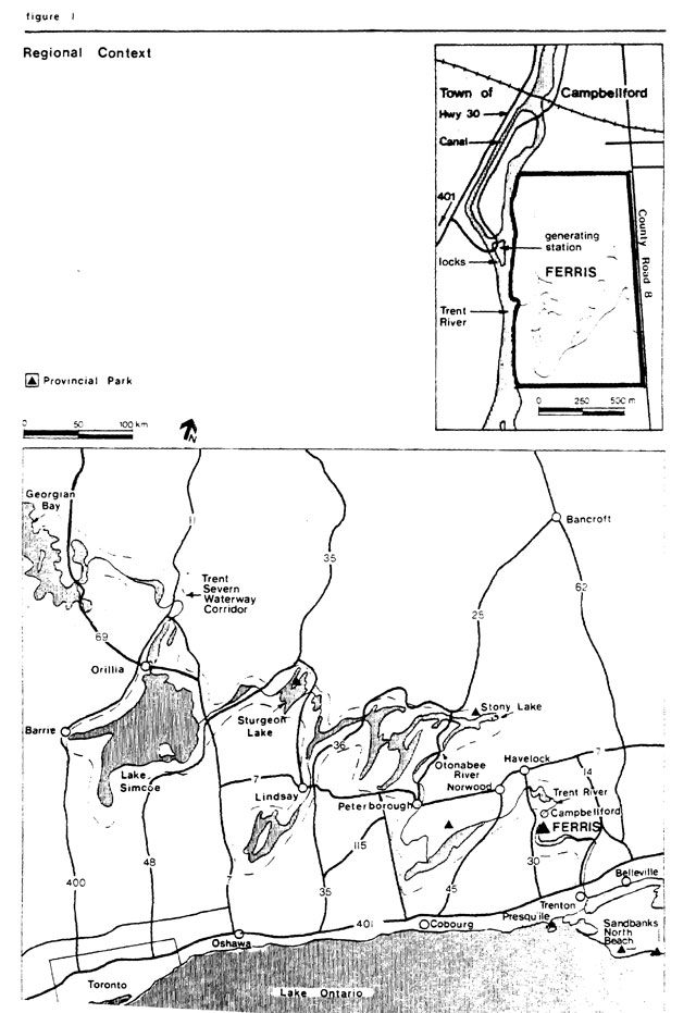
Figure 1 - Regional context
Enlarge Figure 1 - Regional context map
1.0 Introduction
Donated by the descendants of James Ferris, parkland comprising 62 ha was put into regulation as a provincial park in 1962. The Ferris family had allowed use of the property overlooking Ranney Falls on the Trent River adjacent Campbellford for community picnics since before the turn of the century. Additional parcels marked by stone fences criss-crossing the partially cleared drumlins were later acquired. Today the park occupies 218 ha on the Trent-Severn sector of the historic Rideau-Trent-Severn Waterway corridor. This includes a 20 ha acguistion in the southeast corner of the park, now being put into regulation.
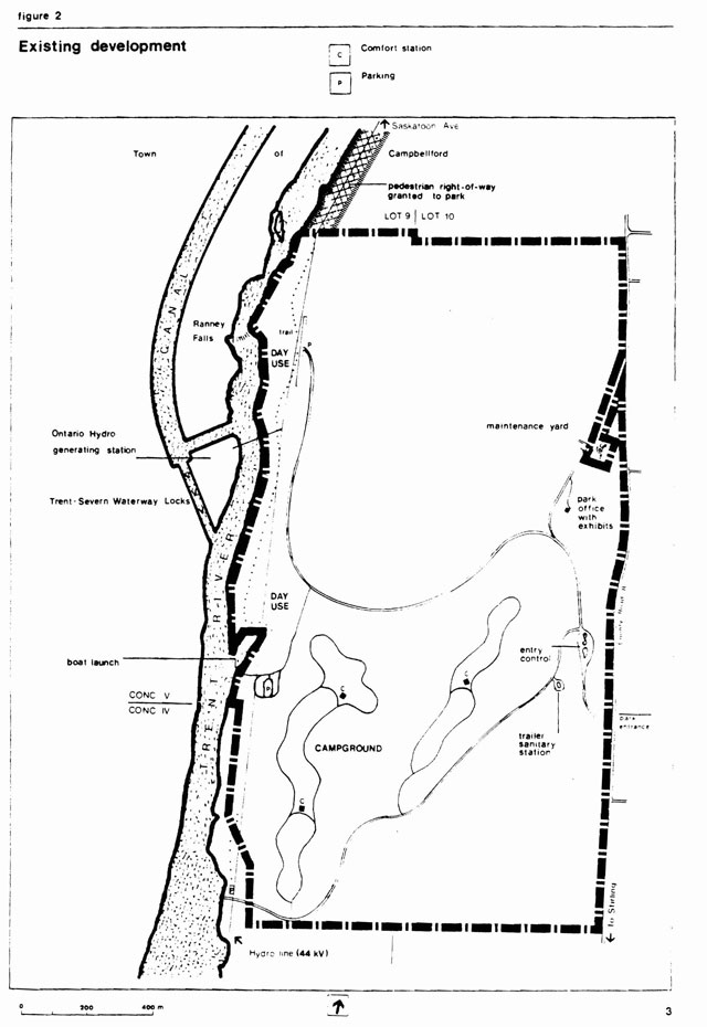
There are 163 campsites arranged in two loops in the park. One loop occupies the top of one of the park’s drumlins and offers unbroken views of the surrounding countryside. The other loop is closer to the Trent River at the base of the same drumlin. A comfort station with shower facilities is available in the upper loop. Interpretive displays at the park office feature the history of the development of the surrounding area and the Trent Canal. Other facilities include a boat launch, picnic areas and a trailer sanitary station. See Figure 2. The park offers opportunities for shoreline fishing, hiking through open fields and forests and a rich variety of birds.
1.1 Issues
Site district representation
One of the objectives of the provincial park system is to protect provincially significant elements of the natural and cultural landscape of Ontario. There is a deficiency for representation of the physiographic area known as the Peterborough drumlin field in the provincial park system. Although encompassing part of it, the park is unsuitable in size and quality to be representative of this feature. In this regard the park will be managed for educational and interpretive purposes while more suitable representation will be sought elsewhere. At the park the natural history of the site district will be explained through self-use displays, trails, publications and with the help of gate staff.
Swimming
The provision of a swimming area at Ferris is a priority. It is required to fulfill the park’s recreation objective; will increase visitor satisfaction with the park, and serve to increase destination travel to the park. Poor water quality in the Trent River in the past suggests that swimming be provided separate from the river.
2.0 Classification
Ferris is now classified as a natural environment park. It will be changed to a recreation park classification. Though there are several natural features which the park represents, it is smaller than the ministry’s guidelines recommend for natural environment parks and its degree of disturbance is significant. A recreation park classification reflects the large proportion of the park which is developed while still affording recognition and protection of natural features through zoning.
3.0 Goal and objectives
Figure 2 - Existing development
Enlarge Figure 2 - Existing development map
Within the framework of this goal are the following objectives [20]:
3.1 Protection
The drumlins, stone fences, glacial outwash and wetland within the park are characteristic of this part of the province. Their protection will be assured through zoning and management policies.
3.2 Recreation
Ferris provides the following recreational opportunities.[16] picnicking 27,165 (4%); camping 43,680 (14%) (Shown in brackets is % of Napanee District supply.)
The park affords a special chance to enjoy the outdoors in the rolling topography of the Peterborough drumlin field. The campgrounds take particular advantage of this setting while the day use facilities capitalize on the attraction of the Trent River, its rapids, waterfalls and fishing.
The two campground loops have adequate space to handle a substantial increase in use. However, an area has been set aside if expansion is warranted in the long term. See Figure 5. The Napanee District Land Use Guidelines identify an available potential here of 30,030 additional camping opportunities by the year 2000.[16, p.43]
The park is now used mainly by families and couples between the ages of 25 and 44, the majority of whom come from the Toronto area. It is also used as an overflow to accommodate visitors when popular nearby parks such as Sandbanks and Presqu’ile have no vacancies. Tents are the most common camping equipment used for the normal one or two night stay. Popular activities are similar to other provincial parks: relaxing, walking, photography, casual play and picnicking. A notable exception is swimming: there is no suitable swimming area in the park. Some visitors camp at Ferris and use their permits for daily access to Presqu’ile and Sandbanks for swimming. See Figure 1. Free admission to a pool run by the Town of Campbellford is also available to park users.
The need for swimming at the park has been noted repeatedly in carments on camper permits and in camper surveys in 1979 and 1984.[17][18] Limited opportunities for swimming are available in the vicinity of the park[23] and the Napanee District Land Use Guidelines list a shortage of swimming opportunities in the district.[16, p.43] The development of a swimming facility in the park is part of the guidelines strategy to meet recreation and tourism objectives in the district.[16, p.44] Use of the facility would be monitored to assess visitor satisfaction with it compared to the extensive lakeshore beaches offered at Presqu’ile, Sandbanks and North Beach.[16, p.44] The benefits of developing a swimming facility include increased visitor satisfaction and length of stay, increased local use and destination travel to the park.
3.3 Heritage appreciation
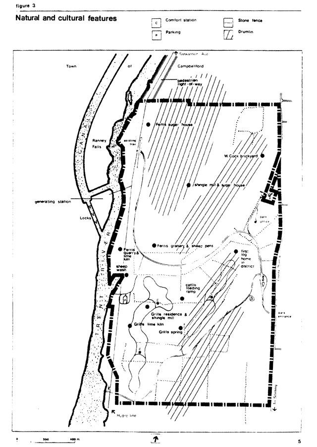
Figure 3 - Natural and cultural features
Enlarge Figure 3 - Natural and cultural features map
The park, situated on the historic Rideau-Trent-Severn Waterway corridor, includes a small portion of the Peterborough drumlin field and a number of cultural features such as farm building and industrial sites, long stretches of stone fence and former farm fields. See Figure 3. These and surrounding area features will be promoted to park visitors to foster an appreciation of the area’s natural and cultural heritage.
3.4 Tourism
Park visitors’ exploration and enjoyment of the park and surrounding region, particularly the Peterborough drumlin field and the Trent-Severn Waterway, will be encouraged. Interpretive publications or other means will be developed to promote self-guided road and waterway tours.
The Trent-Severn Waterway, a very popular recreational boating link between Lake Ontario and Georgian Bay affords a range of alternative and complementary facilities for its users. Much of the day use along the waterway occurs toward its eastern end, although generally west of the park, where there is a wider variety of potential recreational activities and more areas of sight-seeing enjoyment.[3, p. 42] There is a need for more day user facilities throughout the eastern end of the waterway.[3, p. 42] Park visitors will be encouraged to use the Trent-Severn Waterway and waterway users will be encouraged to use the park’s interpretive and recreational facilities. Boat docking and rental developments are needed to facilitate this use.
4.0 Park boundary
Near the southwest corner of the park, two riverfront parcels comprising 4.5 ha in the north half of Lot 9, Concesssion IV will be sought for inclusion in the park. A narrow right-of way along the shoreline of the Trent River leading to Saskatoon Avenue provides pedestrian access to the park from the town. Specifically, this right-of-way granted to the province is described as the width of Saskatoon Avenue extending from the south boundary of Lot 1 in Block XXXV in the Town of Campbellford, southerly along the east bank of the Trent River to the line between Concession 5 and Concession 6 (the park’s north boundary) in the Township of Seymour. This right-of-way is not within the regulated boundary of the park. The regulated eastern boundary of the park will be changed to accommodate the straightening of Northumberland County Road 8 and to include a 20 ha acquisition in the southeast corner of the park. See Figure 5.
5.0 Zoning
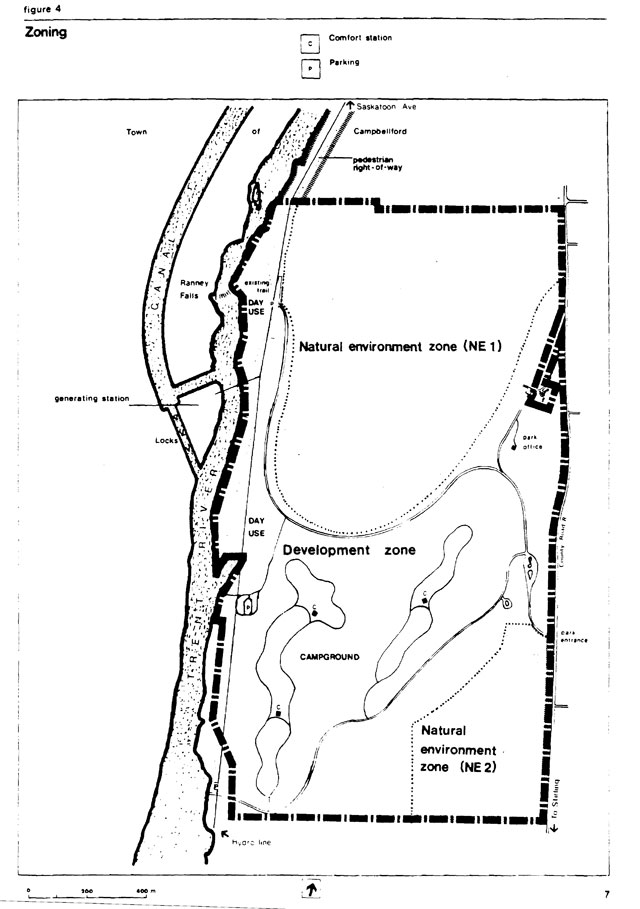
Two types of zones are designated: two natural environment zones to encourage the re-establishment of parts of the park to native vegetation and a development zone to recognize those parts of the park which have been developed or are capable of supporting new development. See Figure 4.
Figure 4 - Zoning
5.1 Natural environment zones
One natural environment zone, NE 1 (84.0 ha) covers two drumlins and the intervening valley in the north half of the park. A smaller zone, NE 2 (24.3 ha) in the southeast of the park encompasses the eastern slope of one drumlin and an area of glacial outwash, part of which is wetland with a small area of muck soil. The management principle for these natural areas is to allow them over time, to erase the signs of disturbance from past uses. This means complete natural replacement of open field herbaceous species with tree and shrub species and the re-establishment of some species in less disturbed areas. A vegetation management plan will be prepared to address management of these areas in more detail. Where possible, the natural environment zone policies will be reinforced by encouraging native vegetation to re-establish on lands adjacent to these zones.
While the natural environment zones at Ferris do protect small samples of the Peterborough drumlin field and the glacial Lake Iroquois embayment, better representation will be sought. The features protected in the park will serve to pique visitor interest in sirnilar sites outside the park.
5.2 Development zone
The development zone (110.1 ha), the central part of the park, encompasses the two campground loops, the various day use facilities which stretch the length of the park, the access roads, maintenance facilities and the park office. The proposed 4.5 ha addition to the park would be included in this zone. It also includes lands to the south of the campground capable of supporting campground expansion should use increase to warrant this. This zoning reflects the more intensive use of these areas.
Generally, areas with greater capacity to support this use were selected. However, special management will be required where this capacity is low or exceeded. Some picnic area development occurred on shallower soils underlain by limestone along the Trent River. Rather than abandoning these uses, carrying capacity will be increased when required by adding topsoil or by introducing more resilient or protective surfaces such as boardwalks and stairways.
Park development tended to occur where earlier land uses were found. Campground loops were laid out on former cultivated fields and inhabited areas. Scattered throughout this development zone are cultural features such as former farm building sites and industrial sites with few visible remnants. Information will be provided through brochures or signs on site. These sites and the many kilometres of stone fences give a particular character to the park and will be protected during any development work.
This zone will be managed to maintain and enhance the recreational opportunities provided as well as the visual character and historical context of the drumlin landscape with its associated pattern of stone fences and hedge rows.
6.0 Resource management
In general the park will be managed in accordance with the ministry’s planning and management policies for recreation class parks.[19] At Ferris three components of resource management will be emphasized: allowing the former cultivated fields and disturbed forests to return to a more natural state, oarticularly in natural environment ones; maintaining and enhancing the visual character and historical context associated with the stone fences, hedge rows and drumlin topography, particularly in the development zone; and maintaining the quality of the setting in areas of low carrying capacity. Specific application of these and other resource management policies are set out below. The Background Information document contains more detailed information on the park’s resources and in particular its soils and their carrying capacities.[12]
6.1 Land-form
The park’s landscape is dominated by drumlins and their characteristic rolling topography. Natural environment zones have been designated to protect larger examples of these features in the park. In the development zone the eastern boundary of the park, where it now skirts a small drumlin, will be altered, transferring same property to the County of Northumberland to allow straightening of the county road. Steps to reduce the disturbance of slopes and to stabilize slopes will be established prior to construction.
Foot traffic along the shoreline may cause an impact on the shallow soils. This situation will be monitored and remedial measures taken if loss of vegetation and erosion occurs.
6.2 Water
The park provides a safe source of drinking water. It will continue to be purchased from the town of Campbellford. The ministry will continue to cooperate in any efforts to resolve pollution problems on the Trent River. Adjacent to the park, the waters of the Trent River are used by Parks Canada in operating the canal and locks of the Trent-Severn Waterway and by Ontario Hydro to generate electricity at Ranney Falls. The ministry will review with Parks Canada and Ontario Hydro the feasibility of a water volume increase to improve the aesthetics of Ranney Falls. The possibility of re-opening springs to supply a swimming complex will be investigated. See section 8.1.
6.3 Vegetation
A vegetation management plan will be prepared providing more detail on the following items. The existing tree cover along the north and south boundaries of the park and extending south along the Trent River shoreline will be maintained for its aesthetic value and its function as a sound and visual buffer.
Planting will be undertaken to provide buffering between campsites and shade although a semi-open character and views from the upper loop will be maintained.The existing red pine and white spruce plantation will be used as a source of material for planting in the campgrounds. Thinning of the plantation and the continued establishment of native hardwood species will result in a more natural appearance and species mix while continuing to buffer the campground from the day use access road.
Sections of the day use access road shoulder will be kept clear of most tree growth to maintain views of the stone fences. This practice will also be followed at other locations to take better advantage of this special feature of the park.
Agreements with Ontario Hydro will be sought to limit vegetation control along the hydro rights-of-way to non-chemical, selective methods. Any planting on or near the right-of-way will be reviewed with Ontario Hydro to ensure compatibility.
Herbicides may be used to eradicate poison ivy along park trails and at other use areas. Spraying with insecticides or fungicides will only be initiated to control severe disease and insect infestations affecting vegetation, particularly if adjacent properties are threatened. Application of herbicides will follow the Pesticides Act and Regulations and the approval of the Regional Director.
Any forest fires will be extinguished in keeping with provincial fire management policies and plans.[10] Vegetation management for maintenance of bird habitat will be considered as described in the following section.
6.4 Wildlife
No hunting will be allowed in the park. A brief wildlife management plan will be written geared to maintaining the excellent bird habitat and viewing which the park offers. This may include maintaining some fields in early successional stages by burning or mowing; retaining some of the park’s large dead elms for nesting; and protection measures for a pair of ospreys nesting on utility poles near the river.
6.5 Fish
Although the Trent River is outside the park boundary, sport fishing for smallmouth bass, yellow perch, bluegills and rock bass in the river will be encouraged at the park. The park provides boat access to the river and trail access to shoreline fishing spots is planned. No spawning activity has been identified in the river near the park.
6.6 Cultural resources
The stone fences which criss-cross Ferris are reminders of the farms which once occupied the park. They portray historic themes and impart a unique feeling to the park. See Figure 3. Management will be geared to protecting the stone fences from development, vandalism or scavenging. Views to the stone fences will be maintained by clearing low roadside vegetation in certain areas. Old farm building sites; sites such as the Cock brickyard and homesite; the Ferris/Grills limestone kiln and quarry and several maple sugar shacks have been mentioned in oral histories of the park. Very little evidence of these structures remains. A study identifying the precise locations of these features will be done. Depending on the results of this study a cultural resources management plan may be required.
7.0 Operations
A park operations plan will be prepared to provide park staff with the necessary information required to operate the park on a day to day basis. A visitor services plan and a marketing plan are components of this operations plan. Direction for the preparation of these plans will be taken from the policies which follow. In addition to visitor services and marketing, the operations plan will address budget, staffing, maintenance schedules, enforcement and emergency services. The provisions of the plan will be consistent with the Ontario Provincial Parks Provincial Operating Standards[21] and will be reviewed annually and updated as required.
7.1 Visitor services
To provide detailed direction for the implementation of the information, interpretation and recreation objectives, a visitor services plan will be prepared for Ferris Provincial Park.
Exhibits on settlement and canal construction in the lower Trent River valley are located in the park office. The visitor services plan will address alternatives to improve the accessibility of the exhibits in the park office and select one of these. See section 8.4. The visitor services plan will be in keeping with the regional visitor services plan[11] and will be coordinated with Ministry of Natural Resources Central Region which shares responsibilities for representing and interpreting the drumlin field geomorphology and the Trent-Severn Waterway corridor. Cooperative arrangements will be investigated with Parks Canada and with the Friends of the Trent-Severn Waterway to enhance visitor services at the park.
7.1.1 Information
Communications will provide visitors with information about park and area facilities and programs. Information on the provincial parks system, eastern Ontario provincial parks, park management and on services available in the vicinity of Ferris will be provided. There will be opportunities for visitors to provide comments and suggestions in return. The visitor services program at Ferris will be oriented to self-use facilities with no specialized staff.
7.1.2 Interpretation
Through printed material, self-use facilities including trails and exhibits and through informal personal contact, the natural and cultural features and other attractions in the area will be interpreted. Self-guided road and waterway tours will be suggested to encourage exploration of the park’s surroundings. Emphasis will be placed on helping visitors understand and enjoy these natural and cultural features and so appreciate the objective of protecting them.
Ferris is suitably located for use by surrounding community schools as an outdoor education resource. The park’s facilities will be available for this use. Resource information will be made available to teachers and other group leaders. This use will occur mainly during fall, winter and spring seasons.
7.1.3 Recreation
Opportunities for informal outdoor recreation will be available. Organized events and activities will generally not be provided unless arranged in cooperation with other agencies or clubs.
Marketing
To increase use, particular attention will be given to promoting the park to travellers using Provincial Highways 401 and 7 and to boaters using the Trent-Severn waterway. Both car and boat travellers will be encouraged to stop and explore the park. Emphasis will focus on the park’s campground, its trails and its scenic and heritage resources combined with local area attractions. The park’s marketing plan[13] will be updated regularly to reflect current efforts. Cooperation with the Friends of the Trent-Severn Waterway will be investigated in marketing efforts for the park.
8.0 Proposed development
In keeping with the goal of providing opportunities to enjoy the natural features and recreational opportunities of the Peterborough drumlin field and the Trent River and Canal, park development is proposed as described below. Developments will be completed according to Figure 5, these guidelines and appropriate site plans.
Figure 5 - Proposed development
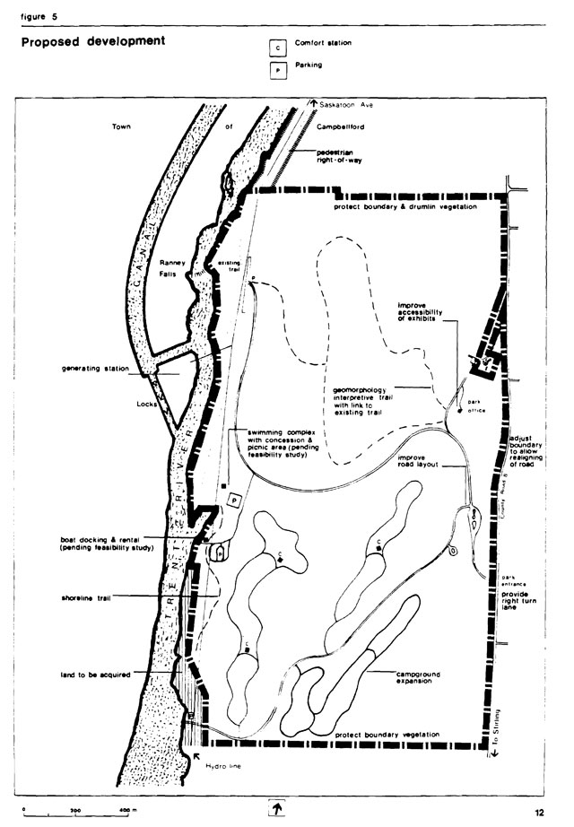
Enlarge Figure 5 - Proposed development map
8.1 Swimming complex
Since the park opened in 1975 few visitors have missed comnenting on the lack of swimming opportunities.
As well, the District Land use Guidelines identify a shortfall of swimming opportunities within Napanee District.[16, p.43] The absence of facilities for bathing, sunning and water play is a major factor limiting growth in use of the park. The rugged limestone shoreline of the park and the unpredictable water quality of the Trent River make the development of a river based facility questionable. A hydrological engineering and site planning study is required to investigate the feasibility of establishing an inland swimming complex in the area of the Sheepwash Cove. In addition to swimming and water play activities, boat rentals and docking facilities and other concession services could be provided. Ontario Hydro and Parks Canada will be consulted as this planning study progresses, particularly regarding boating safety.
8.2 Campgrounds
An area has been set aside for expansion if warranted in the long term. Native species planting will be started now in the open field where this expansion would occur. Planting will be carried out to provide buffering between campsites and shade trees in the existing loops but a semi-open character and the views from the upper loop will be maintained. Thirty sites in the proposed campground loop will have electrical service with the option of adding more as demand warrants.
8.3 Trails
A shoreline trail running the length of the park linking with existing trails atop the cliffs overlooking Ranney Falls will be completed. The trail will provide access to shoreline fishing spots and small openings at prominent view points. It will also link several locations of geological interest including the karst feature, waterfalls and the two fossil laden limestone deposits exposed at the cliffs.
An interpretive trail featuring geomorphology and vegetation site types will start at the park office, continue west to the drumlins, link with the shoreline trail and return to the park office. See Figure 5.
Printed trail guides, on site signs or other means will be used for trail and other site specific interpretation.
Links to a walking and cycling route across from the park via public lands and dams will be encouraged. Details of this proposal will be reviewed with Ontario Hydro to ensure public safety and hydraulic operations are not adversely affected. This trail is now used by pedestrians and cyclists entering the park via Saskatoon Avenue in Campbellford.
8.4 Park office exhibit
The exhibit in the park office tells the story of the colonization of the lower Trent River and canal construction. At Ferris the level of park use does not justify staff time to keep this exhibit open regularly. Alternatives will be considered to make it more accessible to park visitors. In order of preference these include: a) modifying the exhibits with suitable protection for outdoor use at the day use area; b) using volunteers when staff are not available at the park office; c) incorporating the exhibits in the proposed swimming complex and d) increasing staff levels as park use increases with proposed swimming complex development. The visitor services plan will determine the most appropriate solution.
8.5 Traffic
The main entrance to Ferris controls access to both the campground and day use areas. Driving from the campground to the day use area requires an awkward left turn at this entrance. This will be corrected through redesign. If the exhibits in the park office remain in their present location (see preceding paragraph), changes will be needed to make traffic flow to the office more direct, by making the maintenance yard access the secondary route. In cooperation with the County of Northumberland, a new right turn lane from County Road 8 will be built at the park entrance.
8.6 Winter use
To improve skating, toboganning and cross-country skiing opportunities, cooperative arrangements with a private operator or local service clubs or associations will be pursued. Snowmobiles will be restricted to travel on main park roads.
9.0 Implementation
Facility improvements, studies and resource management plans discussed in this management plan are listed below in the order they should be completed. Ministry of Natural Resources priorities will determine when projects can be undertaken. All development work will follow approved site plans.
On-going projects
- consultation with Parks Canada and Friends of the Trent-Severn Waterway recooperation on visitor services
- consultation with local service clubs or individuals re winter recreation opportunities
Phase I
- feasibility study for swimming complex (hydrological engineering and site planning)
- boat docking and rental facility
- operations plan including visitor services plan and marketing plan update
- wildlife management plan
- vegetation management plan
- design and implementation of planting plan for proposed campground
- studies investigating ways to protect tree buffer along north and south boundaries
- planting in campgrounds
- land acquisition and boundary change regulations
Phase II
- develop swimming complex and concession services
- cultural resources inventory
- shoreline hiking trail
- lay out and develop geomorphology trail; design and produce brochure
- design and produce on-site interpretation for earth science features
Phase III
- design and produce publication on features and attractions in surrounding area
- cultural resources management plan as required
10.0 Public consultation
As part of the planning process park users, local governments, adjacent land-owners, local clubs and other agencies and individuals with an interest in the management of the park were consulted and the 1985 preliminary plan was made available to than. Background information was also available for review. The background information and copies of the preliminary plan were available through the Ministry of Natural Resources regional office at Kemptville, the district office at Napanee and the Ferris Provincial Park office.
In the summer of 1985, news releases were sent to local radio stations and newspapers inviting the public to review and comment on the 1985 preliminary management plan. A display was set up at the park to solicit comment from park visitors. Another display was set up at the Campbellford Public Library to provide town residents an opportunity to review and comment on the preliminary management plan. A number of agencies and individuals with an interest in Ferris Provincial Park are also sent copies of the plan and asked for their comments.
Written comments were received from five park visitors, the Town of Campbellford, the Township of Seymour, Ontario Hydro and Parks Canada. There was general support for the policies, facility improvements, studies and resource management plans presented in the preliminary management plan. Concerns raised in response to the preliminary plan have been addressed in this approved management plan. Incorporating same minor changes and updating, this approved management plan confirms the park policies set out in the 1985 preliminary management plan. It will guide the management of Ferris Provincial Park for the next 20 years.
Bibliography
- Bean, D. Land-form Survey of Ferris Provincial Park, Seymour Township, Northumberland County, Ontario. Unpublished report. Lindsay District: Ontario Department of Lands and Forests, 1972.
- Burns, James A. Archaeological Survey of Ferris Provincial Park, Seymour Township, Northumberland County, Ontario. Unpublished report. Lindsay District: Ontario Department of Lands and Forests, 1972.
- Canada/Ontario Rideau/Trent Study (CORTS) Committee. Yesterday, Today, Tomorrow: Rideau-Trent-Severn. Toronto: Queen’s Publisher, 880 Bay Street, 1973.
- Chapman, L. J. and D. F. Putnam. The Physiography of Southern Ontario. Second edition. Toronto: University of Toronto Press, 1966.
- Mirynech, E. Pliestocene Geology of the Trenton-Campbellford Map Area, Ontario. Ph.D. Thesis. University of Toronto. 1962.
- Ontario Departrrent of Lands and Forests. Ferris Provincial Park, Master Plan. Unpublished report. Circa 1971.
- Ontario Ministry of Municipal Affairs and Housing. 1983 Municipal Directory. ISSN 0318-0743. Toronto: Queen’s Printer for Ontario, 1983.
- Ontario Ministry of Natural Resources. A Framework for the Conservation of Ontario’s Biological Heritage. Draft report. Toronto: Parks and Recreational Areas Branch, 1980.
- Ontario Ministry of Natural Resources. A Topical Organization of Ontario History. Toronto: Division of Parks, Historical Sites Branch, 1975.
- Ontario Ministry of Natural Resources. Aviation and Fire Management Policy #AF 03.01.01. Sault Ste. Marie: Aviation and Fire Management Centre, 1983.
- Eastern Region Provincial Parks Visitor Services Policies & Guidelines. Unpublished report. Kemptville: Parks Branch, 1986.
- Ontario Ministry of Natural Resources. Ferris Provincial Park Background Information 1984. Unpublished management planning report. Kemptville: Parks Branch, 1984.
- Ontario Ministry of Natural Resources. Ferris Provincial Park Marketing Plan. Unpublished report. Napanee: Parks Branch, 1983.
- Ontario Ministry of Natural Resources. History of Ferris Provincial Park. Unpublished report. Toronto: Provincial Parks Branch, 1971.
- Ontario Ministry of Natural Resources. Lindsay District Land Use Guidelines. Lindsay, 1983.
- Ontario Ministry of Natural Resources. Napaneee District Land Use Guidelines. Publication Number Napanee, 1983.
- Ontario Ministry of Natural Resources. 1979 Provincial Park Camper Survey Summary Statistical Report. Toronto: Parks and Recreational Areas Branch, 1980.
- Ontario Ministry of Natural Resources. 1984 Provincial Park Camper Survey Summary Statistical Report. Toronto: Parks and Recreational Areas Branch, 1985.
- Ontario Ministry of Natural Resources. Ontario Provincial Parks Planning and Management Policies. Toronto: Park Planning Section, 1978.
- Ontario Ministry of Natural Resources. Ontario Provincial Parks Policy. Publication Number 5739. Toronto: Provincial Parks Branch, 1978.
- Ontario Ministry of Natural Resources. Ontario Provincial Parks Provincial Operating Standards. Publication Number 3691. Toronto: Parks and Recreational Areas Branch, 1986.
- Ontario Ministry of Natural Resources. Ontario Provincial Parks Statistics 1983. Publication Number 5628. Toronto: Parks and Recreational Areas Branch, 1984.
- Ontario Ministry of Natural Resources. Ontario Recreation Supply Inventory. Unpublished report. Toronto: Policy Coordination Secretariat, 1980.
- Ontario Ministry of Treasury, Economics and Intergovernmental Affairs. Ontario Population Projections to 2001. Toronto, 1974.
- Pratt, W. Ferris Provincial Park, Habitat and Wildlife Inventory. Kemptville: Ontario Ministry of Natural Resources, 1979.
- Rowe, J. S. Forest Regions of Canada. Publication Number 1300, Ottawa: Department of the Environment, Canadian Forestry Service, 1972.
- Tourism and Outdoor Recreation Planning Study Committee. Tourism and Recreational Behaviour of Ontario Residents, Volumes 1 to 8. Toronto: Queen’s Park, 1977.
- Turner, Larry. The pioneer Period of Trent Watershed Lumbering. Unpublished report. Ontario Ministry of Natural Resources, Napanee District, 1977.
- Turner, Larry. Bibliography of the Trent Watershed. Unpublished report. Ontario Ministry of Natural Resources, Napanee District, 1977.
- Warder, M. P. Ferris Provincial Park: Biological Analysis. Unpublished report. Lindsay District, Ontario Department of Lands and Forests, 1971.
- Woerns, N. Ferris Provincial Park, Earth Science Check-sheet. Revised by S. van Haaften. Kemptville: Ontario Ministry of Natural Resources, 1977.