Field Township Conservation Reserve Management Statement
This document provides policy direction for the protection, development and management of the Field Township Conservation Reserve and its resources.
Statement of Conservation Interest (C167)
Ontario Ministry of Natural Resources
North Bay District
January 2005
Approval statement
We are pleased to approve this Statement of Conservation Interest (SCI) for the Field Township Conservation Reserve (C71).
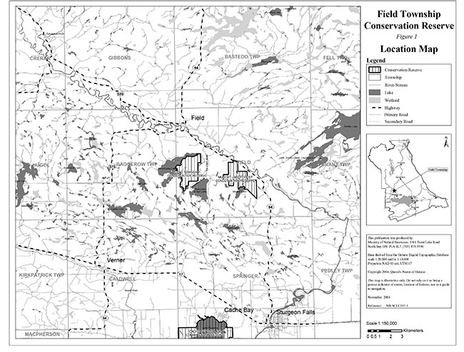
Field Township Conservation Reserve is located in Ecodistrict 5E-6 approximately 20 km northwest of Sturgeon Falls between Bain and Muskosung Lakes southwest of Highway 64 (Figure 1). The boundary of the conservation reserve is located in the geographic townships of Field and Badgerow now within the Municipality of West Nipissing, District of Nipissing (Figure 2). The western and northwestern part of the conservation reserve borders Muskosung Lake. The conservation reserve is known to encompass significant life science values. A mixed forest community with significant wetland vegetation dominates the area.
During the Lands for Life planning process the public was widely consulted and provided valuable input into what became Ontario’s Living Legacy which is now part of the Crown Land Use Policy Atlas. Comments received during that time, and during consultation related to the formal Public Lands Act regulation of the boundaries of this conservation reserve were generally supportive of the protection of this area.
Stakeholders who expressed an interest in the planning of this site were also notified regarding the draft SCI and given a two week review period. Any comments, including input from previous consultation, were considered in the finalization of this document. Little interest and no new issues or concerns were expressed by the public during the review of this draft SCI. The draft was reviewed by MNR district specialists located on area teams who are responsible for the management of particular areas within the district, which include this conservation reserve.
This basic SCI provides guidance for the management of the conservation reserve and the basis of the ongoing monitoring of activities. More detailed direction is not anticipated at this time. Should significant facility development be considered or complex issues arise requiring additional studies, more defined management direction or special protection measures, a more detailed Resource Management Plan will be prepared with full public consultation.
Field Township Conservation Reserve is managed under the direction of the District Manager and the Tomiko Area Supervisor, North Bay District, Ministry of Natural Resources.
Prepared by:
Klara Vodicka
District Planning Intern
January, 2005
Original signed by:
Bill Hagborg
Acting District Manager
North Bay District
Date: March 29, 2005
Original signed by:
Rob Galloway
Regional Director
Northeast Region
Date: April 5, 2005
1.0 Introduction
The purpose of this Statement of Conservation Interest (SCI) is to identify and describe the values of Field Township Conservation Reserve. The SCI outlines the activities that occur within the conservation reserve and provides guidelines for the management of current and future activities in the context of protecting the natural, social and cultural values of the conservation reserve. A SCI is prepared under the authority of Procedural Guideline A – Resource Management Planning (PL. Procedure 3.03.05).
Field Township Conservation Reserve is a 399 hectare parcel of Crown land located southwest of the Sturgeon River between Muskosung and Bain Lakes, known locally as Clear Lake, approximately 20 km northwest of Sturgeon Falls. The boundary of the conservation reserve is located in the geographic townships of Field and Badgerow within the municipality of West Nipissing (figure 1). The mixed deciduous and coniferous forests and wetlands provide optimal habitat for a variety of wildlife and thus recreational hunting opportunities within the conservation reserve.
Conservation reserves are established by regulation under the Public Lands Act. Field Township Conservation Reserve was established by Ontario Regulation 208/03, under authority of the Public Lands Act (O. Reg. 805/94) on February 14, 2003. The planning area for this SCI is the regulated boundary of the conservation reserve.
1.1 Planning context
Ontario’s Living Legacy Land Use Strategy was approved in 1999. The objectives of the Land Use Strategy are to complete Ontario’s system of protected areas; recognize the land use needs of resource-based tourism industry; provide forestry, mining and resource industries with greater certainty around land and resource use; and enhance hunting, angling and other Crown land recreational opportunities. Field Township Conservation Reserve was created as part of the expansion of protected areas.
Conservation reserves protect natural heritage values on public lands, while permitting compatible land use activities. By allocating these lands to the parks and protected areas system through regulation, the province has ensured a certain level of permanence by distinguishing the conservation reserve and its values from the larger general use or more extensively managed landscape. In addition, the conservation reserve’s natural features are, and will be available for present and future generations to enjoy and explore.
The Land Use Strategy (1999) and the Crown Land Use Policy Atlas outlines the general land use policy and management direction for new conservation reserves. Each new conservation reserve will have a planning document, either a SCI or, in more complex situations, a Resource Management Plan, that details site-specific management direction.
Comments received during the Lands for Life process, and during consultation related to the formal regulation of the boundaries of this site were generally supportive of the establishment of this area as a conservation reserve.
Although more detailed direction is not anticipated at this time, should significant facility development be considered or complex issues arise requiring additional studies, more defined management direction or special protection measures, a more detailed Resource Management Plan will be prepared with full public consultation.
1.2 Background information
Field Township Conservation Reserve is a mixed deciduous and coniferous forest southwest of Highway 64 and approximately 3 km directly south of the Town of Field. The site formerly on the boundary of Site Districts 5E-5 and 5E-6 (Hills, 1959) now falls within Ecodistrict 5E-6 (Crins, 2000) in the revised version of Hills original Site Regions and Districts. The conservation reserve is surrounded by patent land, Crown land and the water’s edge. A significant portion of the conservation reserve borders Muskosung Lake (figure 1). This 399 hectare area was protected in order to preserve the valuable life science features and wildlife habitat associated with the site. The site can be accessed by trail from Northshore Road, however because of the vectored boundaries of the conservation reserve a 500 meter section of Crown land must traversed before entering the site. The site may also be accessed by water via Muskosung Lake and by snowmobile trail in the winter that runs through the southern and northern portions of the site.
The following chart summarizes administrative information for Field Township Conservation Reserve:
| Name and OLL ID Number | Field Township Conservation Reserve (C167) |
|---|---|
| Ecoregion/Ecodistrict (Hills, 1959; Crins, 2000) | 5E (Georgian Bay), 5E-6 (Tomiko) |
| OMNR Administrative Region/District/Area | Northeast Region/North Bay District/ Tomiko Area |
| Total Area (ha.) | 399 |
| Regulation Date | February 14, 2003 (O. Reg. 208/03) |
| Township(s) | Geographic Townships of Field and Badgerow Municipality of West Nipissing, District of Nipissing |
| First Nations | Nipissing First Nation – area of interest – through the Robinson Huron Treaty |
| OBM map sheets | 2017 5700 51500 – 2017 5700 51400 |
| Topographic Map Name/Number | Verner 41 I/8 |
| UTM coordinates | 575,400 m E 5,148,900 m N |
| General Location, Description, Access | Approximately 3 km directly south of the Town of Field and 20 km northwest of Sturgeon Falls. Site contains mixed deciduous and coniferous forest. The site can be accessed by snowmobile trail, Club trail WN 403 and a cottage road originating from Northshore Road. |
1.3 Goals
The goals of this SCI are:
- To provide background information.
- To identify and describe the values of the conservation reserve.
- To provide guidelines for the management of current and future activities while protecting natural, social and cultural heritage values.
1.4 Objectives
The following objectives are identified as a means to achieve the above-stated goals.
- To describe the state of the resource with respect to natural heritage values and current land use activities.
- To manage the conservation reserve to protect the integrity of its natural values via specific guidelines, strategies and prescriptions.
- To meet planning requirements by addressing the management intent of the conservation reserve and addressing planning and management needs.
- To create a public awareness of the values within the conservation reserve and promote responsible stewardship of the protected area through partnerships with local stakeholders.
- To determine long-term management goals of the conservation reserve by identifying research, client services and marketing strategies.
- To identify scientific values on the site in relation to provincial benchmarks and identify the necessary monitoring and/or research to maintain the integrity of those values.
- To provide direction to evaluate new uses or economic ventures through the application of a Test of Compatibility ((Procedural Guideline B) - Land Uses - PL. 3.03.05) (Appendix 1) and Ministry of Natural Resources (MNR) Class Environmental Assessment for Provincial Parks and Conservation Reserves.
1.5 Representation
The following table provides a summary of the life science, earth science and cultural heritage values, as well as recreational opportunities.
| Life science representation: | Fifteen forest communities and three wetland types lying on rolling water-laid lowlands broken by bedrock outcrops The following landform types and vegetation associations are found (Merchant et al., 2004):
|
|---|---|
| Earth science representation: | Field Township Conservation Reserve is underlain by bedrock of the Central Gneiss Belt of the Grenville Structural Province. The area is characterized by water-laid lowlands interspersed with rugged bedrock outcrops. The rock type is predominantly biotite gneiss derived from greywackes and immature sandstone. The surficial layer is made up of bedrock-drift complex, glaciolacustrine deposits and organic deposits. Overall the site is considered to have a low sensitivity to existing land uses within the site with the exception of organic peat deposits, which are more sensitive to motorized traffic. The area is of local significance (Kristjansson, 2004). |
| Cultural heritage values: | Field Township Conservation Reserve was identified as having high potential heritage areas within the site (see section 2.3). The conservation reserve is in the area of interest for the Nipissing First Nation. More in-depth research concerning cultural heritage values has not been completed to date. |
| Recreational opportunities: | The site offers various recreational opportunities including hunting, snowmobiling, ATV use, general viewing opportunities, hiking and potentially birdwatching and photography (Sheppard, 2003). |
1.6 Survey work
The following table provides an overview of inventories completed, their level of detail, and any further inventories that are required.
| Survey Level | Life Science | Earth Science | Cultural | Recreational |
|---|---|---|---|---|
| Reconnaissance | Merchant, B. et al. 2004, Life Science Checksheet Aerial Survey and Ground Survey (in progress) | Kristjansson, F.J.,2003, Earth Science Checksheet, Aerial Survey | First Nations Interviews, 1998 & 2003, Native Background Information Report and Values Maps, related to Forest Management Planning | Sheppard, C., 2003, Recreational Inventory Checklist, Aerial and Ground Survey |
| Detailed | None | None | None | None |
| Requirement | None | None | None | Monitor on an on-going basis |
1.7 Boundary amendment
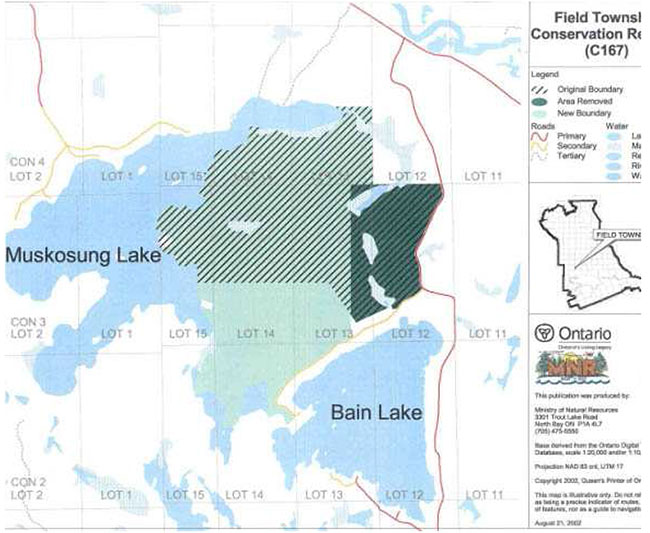
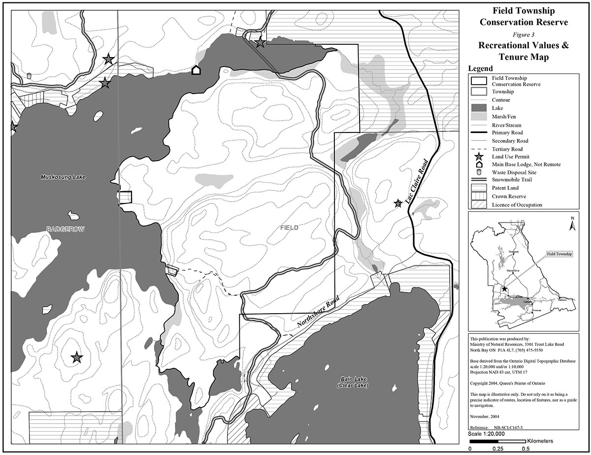
Field Township Conservation Reserve boundary has been amended since the site was first identified through gap analysis. Field Township Conservation Reserve boundary was amended in order to exclude an already existing landfill site located in the eastern portion of the original site near Rue Lac Claire (figure 3). This two hectare landfill site has been situated on Crown land and held under the authority of a MNR Land Use Permit by the Municipality of West Nipissing for the last 25 years. The associated attenuation/ buffer zone for the landfill, which serves as a filter for any leachate that may migrate from the waste site, was not included in the two hectare area of the Land Use Permit. A minor boundary amendment was made in order to exclude both the original landfill site and its associated attenuation/buffer zone from the conservation reserve.
Replacement areas to the south of the conservation reserve were then established. A loss of vegetation on lacustrine deposits was associated with the change in boundary, however, replacement areas incorporated weakly broken ground moraine and related vegetation, which served to maintain representation levels within the site. Both sets of features are still represented to the minimum guidelines set out during the Lands for Life process. The MNR is currently in the process of selling the landfill site and its associated attenuation zone to the Municipality of West Nipissing. It is in MNR's interest to divest itself of the liability associated with the landfill site. The sale of the landfill to the municipality supports a previous commitment from the MNR.
Public Consultation on the proposed boundary amendment and boundary refinement occurred at the same time between September 16, 2002 to October 16, 2002. A posting on the Environmental Bill of Rights (EBR) registry also occurred. A copy of approved amendment is posted on Crown Land Use Policy Atlas (Appendix 3).
2.0 State of the resource
The conservation reserve is located entirely within Ecodistrict 5E-6 (Crins, 2000). Values include life science, earth science, cultural and recreational/aesthetic with an emphasis on the life sciences.
Significance is determined on the basis of the following criteria: representation, diversity, condition, ecological considerations and special features (Crins and Kor, 1998).
Representation:
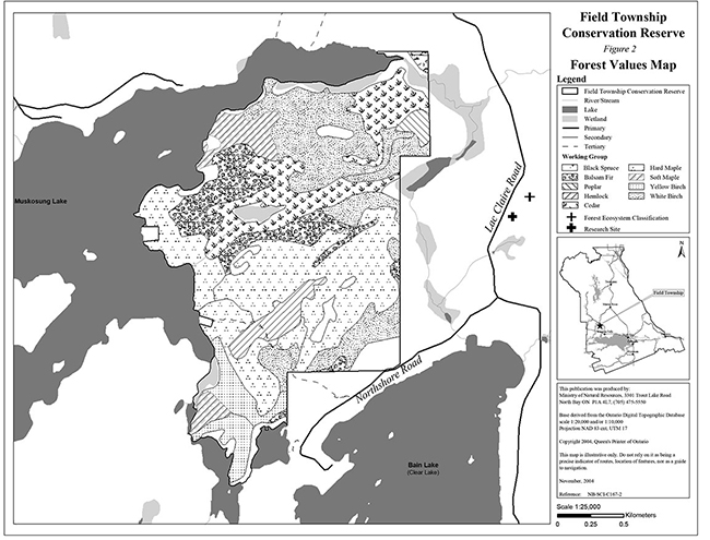
Field Township Conservation Reserve is comprised of mixed deciduous forest with a few small sections of coniferous forest. Wetlands are also present, located mainly along the boundary edges of the site (figure 2).
There are fifteen forest communities and three wetland types found within Field Township Conservation Reserve. The majority of the forest is comprised of mixed deciduous forest. Sugar maple predominant hardwoods make up the largest percentage of the site near the upland central and south central portions of the site. A mixed white birch and cedar dominated coniferous forest make up the next two largest forest communities in the site. The mixed white birch community is located in the northern and southeastern upland section of the site while the cedar community is located in the lower central portion of the site surrounding the only interior wetland. The rest of the forest is comprised of sugar and red maple mixed hardwoods, balsam fir mixedwoods, hemlock mixedwoods, balsam fir yellow birch true mixedwoods, yellow birch predominant conifer and mixedwood, mixed cedar, hemlock yellow birched true mixedwood and small sections of pure sugar maple, pure poplar and black spruce dominant stands. The majority of these stands lie on bedrock-drift complex with moderate bedrock exposure in the form of bedrock knobs, glaciolacustrine deposits and organic deposits.
Wetland communities surround the Muskosung Lake shoreline boundary of the conservation reserve. A small wetland is also present at the eastern section of the site, as well as well as the central interior. Treed muskeg and a few small sections of brush/alder swamp are present along the northern, eastern and central portions of the site, while open muskeg is present along the southern portion of the site. Significant areas of exposed bedrock can also be found throughout.
The diverse forest community and adjacent wetlands provide optimal habitat for a variety of species. Species include deer, moose, bear, upland birds and various fur- bearing mammals. Though not present within the conservation reserve, moose aquatic feeding areas are present within a few kilometers of the site and likely make the area even more desirable for this particular species. Loons are also present in adjacent lakes as well as numerous warm water fish species such as walleye, pike, muskellunge, small mouth bass and largemouth bass. These species may utilize adjacent wetlands that are located within the bounds of the conservation reserve.
Diversity:
Diversity is a measure of the conservation reserve’s earth and life science variety. The evaluation is based on the number and range (assortment) of landscape features and landforms for earth science values and the relative richness and evenness of the site’s life science components.
Field Township Conservation Reserve is fairly diverse in that it exhibits a number of different forest communities and wetland areas. The mixed deciduous vegetation, including sugar maple mixedwoods, with conifers such as hemlock and cedar, makes this area highly suitable for deer and moose populations. Preliminary analysis indicates a highly diverse treed ecosystem and vegetation understory (Merchant et al., 2004).
Condition:
Overall the conservation reserve is in good condition with respect to its natural features. The disturbance for the area has been rated as low. The site is located in a very heavily developed cottage area but the conservation reserve shows little disturbance (Merchant et al., 2004). There is likely some disturbance associated with the two lots located along the western shoreline of Muskosung Lake, which are completely surrounded by the conservation reserve (Merchant et al., 2004). Other disturbances include a cottage road/trail, a snowmobile trail and possible watercraft disturbance along the shoreline of Muskosung Lake. However these trails, and the associated activities including hunting, hiking, general viewing and potentially birdwatching and photography, are believed to have a limited impact on the site. A variety of authorized commercial activities such as baitfishing, trapping and bear management also occur in and around the area. However, these activities are believed to have little impact on the core ecological values of the site. The last major disturbance to take place within the site appears to have occurred approximately 65 years ago. This disturbance could be due to logging activities or a natural phenomenon such as a blow down (Baker, 2004).
There is no known fire disturbance associated with the site within the last 80 years. Natural disturbance within the conservation reserve may include erosion of soil and vegetation from bedrock outcrops. A forest tent caterpillar infestation may also have disturbed parts of the conservation reserve with moderate to severe defoliation occurring near the site in 2002 (Merchant et al., 2004).
Ecological considerations:
Field Township Conservation Reserve is a small 399 hectare site comprised of Crown land. The conservation reserve is bordered by the waters edge, patent and Crown land.
Some of the original life science values identified during the Lands for Life process were not preserved in the final boundary of the site as discussed in Section 1.7. Replacement areas were added to the southern portion of the site, which incorporated different features of similar significance. The western portion of the southern boundary follows adjacent wetland areas, while the eastern portion of the southern boundary was vectored. Overall the conservation reserve is ecologically self-contained along the shoreline boundary, but not along the eastern and southern vectored boundary. The vectored boundaries give rise to dissected forest communities, which have a limited capacity for protection of the site’s interior core values. Land use activities and management of adjacent lands could impact the site in the future, specifically with respect to the Clear Lake Landfill Site. A hydrological study prepared by SNC Lavalin Engineers & Contractors for the Corporation of the Township of Field in 1992 delineated the attenuation zone of the landfill. The degree of leachate impact on the groundwater and surface water in the vicinity of the landfill was considered minor at the time.
Recreational activities may also impact the site, however the area currently exhibits limited use. The main recreational activities include hunting, snowmobiling and ATV use. These activities currently have a low impact on the site.
Special features:
The conservation reserve contains an abundance of different mixed forest communities. These stands include brush and alder thickets, fir and cedar forests, treed wetlands on hummocky ground moraine and birch, poplar, fir, cedar forests, thickets and treed wetland on much flatter outwash deposits. Hemlock was also frequently identified within the site. The presence of conifer species, such as hemlock and cedar, provides optimal living conditions for a variety of wildlife. Hemlock blocks wind and traps radiated heat while intercepting falling snow on its foliage thus creating a lower snow depth beneath the tree while cedar is a preferred browse tree for deer in the winter. Deer and moose are known to utilize these areas for cover.
2.1 Life science
Gap analysis is a method of identifying gaps in representation of all landform/vegetation features within the Ecodistrict, and to identify potential sites that best fill those gaps. The objective of gap analysis is to complete representation of all vegetation community and landform types within protected areas (Bergsma, 1995). This conservation reserve was identified through gap analysis and contains 15 different forest communities as well as 3 different wetlands communities.
The conservation reserve consists of mixed deciduous and coniferous forest. Larger upland portions of the conservation reserve consist of sugar maple predominant hardwoods and white birch mixed hardwoods. A large lowland area consists of cedar mixedwoods. Other forest communities include yellow birch, balsam fir, hemlock, red maple, poplar and black spruce. Wetlands including treed muskeg, open muskeg and brush/alder are also present. The majority of these wetlands are located along the western shoreline boundary of the conservation reserve. Hemlock and cedar provide excellent winter cover and forage for species such as moose and deer as well as a variety of other wildlife.
2.2 Earth science
Field Township Conservation Reserve is underlain by bedrock of the Central Gneiss Belt, Grenville Structural Province, Precambrian Shield. Rock types in the reserve are likely to include migmatitic biotite gneiss, feldspathic gneiss and felsic intrusive rocks. The majority of the site is dominated by bedrock-drift complex with a discontinuous cover of till and moderate bedrock exposure. This bedrock exposure includes rock knobs, which are characteristic of this area. Other drift types, such as glaciolacustrine deposits may also be present. Lowlands occupy the remaining areas within the conservation reserve. An extensive area of glaciolacustrine deposit is present in the central portion of the site surrounding the central interior wetland. It is anticipated that these deposits consist of sandy silt or silty fine sand. Organic deposits underlie many of the wetland areas with the site including those located along the boundaries of the conservation reserve. These organic deposits, and in particular peatlands, may be sensitive to motorized traffic. The bedrock-drift complex and glaciolacustrine deposits are believed to have a low sensitivity and thus are not heavily impacted by existing land use within the site. These geologic features are of local significance.
2.3 Cultural values
There are no archeological sites identified within the conservation reserve. There are some identified high potential heritage areas. High potential cultural heritage areas are identified using a computer based predictive modeling program. Based on a series of pre-defined parameters, the program identifies candidate areas, which are most likely to be culturally significant. The conservation reserve is within the area of interest of the Nipissing First Nation. The conservation reserve is also in close proximity to a heritage canoe route which follows the Sturgeon River.
2.4 Recreational/aesthetic values
Recreational activities such as hunting, snowmobiling and ATV use are popular activities within the conservation reserve. The area is known for its hunting appeal due to the many deer, moose, bear and upland birds that are present within the area. General hiking and viewing are known to take place within the site and there is potential for birdwatching and photography. Local residents as well as visitors are known to frequent the site. A snowmobile trail, also suitable for hiking and ATV use, runs through the site in a north south direction. This trail follows a portion of an existing road that leads to a private recreation camp on patent land. This trail originated from Northshore Road near the southern boundary of the site. A foot trail and scenic lookout (Photo 1) is also present just south of the conservation reserve. This foot trail extends out from the existing snowmobile trail and overlooks an adjacent wetland westward. A heritage canoe route which runs along the Sturgeon River is located northeast of the site. The conservation reserve is highly accessible in that there is a road and are several trails surrounding and within the site. The site can also be accessed by water via Muskosung Lake. The conservation reserve is very close to the Village of Field and a manageable distance from Sturgeon Falls, North Bay and Sudbury.
2.5 Heritage estate contributions
The conservation reserve has been set aside in order to protect the representative life science features associated with the site. The site was identified as possessing significant life science values through gap analysis during the Lands for Life planning process. Key features include:
- Combination of brush and alder thickets, fir and cedar forests and treed wetlands on hummocky ground moraine and birch, poplar, cedar forests, thickets and treed wetlands on flatter outwash deposits
- Highly diverse treed ecosystem and vegetation understory
- Mature hemlock and cedar forest that provide habitat for deer and moose
Additional values and features not described here can be found in sections 2.0 and 2.1. Should a new, significant key value be identified, current management guidelines may be modified to ensure its protection.
3.0 Management guidelines
3.1 Management planning strategies
The land use intent outlined in Ontario’s Living Legacy Land Use Strategy provides context and direction to land use, resource management, and operational planning activities on Crown land. Commitments identified in the above Strategy and current legislation (PL Procedure 3.03.05) will form the basis for land use within Field Township Conservation Reserve. For up-to-date information on permitted uses refer to the Crown Land Use Policy Atlas website.
Existing permitted uses within the conservation reserve may continue, unless they are shown to have a significant negative impact on the values within the site.
Proposed uses and development within the conservation reserve will be reviewed on a case-by- case basis. A Test of Compatibility (Appendix 1) must be passed before they are deemed acceptable. The emphasis will be on ensuring that the natural values of the conservation reserve are not negatively affected by current or future land use activities. Therefore, any application for new specific uses will be carefully reviewed. The Ministry, partner organizations and/or proponents may undertake such studies. Requirements under the MNR Class Environmental Assessment for Provincial Parks and Conservation Reserve will also be met.
3.2 Land tenure
Background:
Field Township Conservation Reserve boundaries have been significantly altered since the site was first identified through gap analysis. The eastern portion of the site was excluded from regulation because of a previously unidentified landfill site, operated under the authority of a land use permit (figure 3).
The site is composed entirely of Crown land and is surrounded by the waters edge to the west, patent land to the northeast and Crown land to the east, which will be patented and sold to the Municipality of West Nipissing in the future because of the associated landfill site. There is one private camp on patent land and two patented cottage lots located along the shore of Lake Muskosung, which have both been excluded from the site. A snowmobile trail also runs through the southern, and northeastern portion of the conservation reserve passing over an existing cottage road that leads to the existing private recreation camp.
Guideline:
The sale of Crown lands within the conservation reserve is not permitted.
New recreation camps are not permitted.
Unauthorized occupations of lands within the conservation reserve will be handled in accordance with approved policy, and any required structural removal will be at the owner’s expense.
3.3 Development and access
Background:
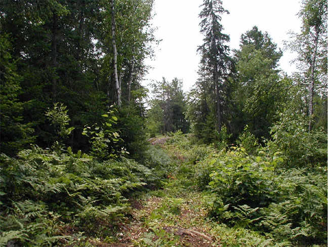
The area surrounding Field Township Conservation Reserve shows a fair amount of cottage development however the conservation reserve itself shows little disturbance (Merchant et al., 2004). A municipal landfill and its associated attenuation/buffer zone are located on Crown land to the east of the conservation reserve. Three private lots along the western boundary of the conservation reserve have been excluded from the site. Access to these lots can be achieved by water via Muskosung Lake. The southern lot can also be accessed by an already existing cottage road that originates from Northshore Road (Photo 2). Access to the conservation reserve may also be achieved by an Ontario Federation of Snowmobile Clubs (OFSC) Club Trail WN 403 (Photo 3), which also serves as an ATV and hiking trail, that runs through the conservation reserve in a north south direction. Additional access can be achieved by boat along the western boundary of the site, which follows the eastern shoreline of Muskosung Lake. A small section of the southern boundary of the site also follows Northshore Road. There is no trail leading into the site from this location and thus access could only be achieved by walking through the existing vegetation. A foot trail and scenic lookout, which extends from the existing snowmobile trail, is also present though just outside the boundaries of the conservation reserve. There are no buildings, facilities or utilities within the conservation reserve (figure 3).
Guideline:
New roads for resource extraction and/or private use will not be permitted, nor will additions to existing roads or upgrading of existing private roads.
New trails are not encouraged, however they may be considered when compatible with other recreational uses and the maintenance of environmental integrity. Any new trail development must go through a Test of Compatibility to ensure the quality of the life and earth science representation and any additional values (e.g. aesthetics, landscape views, sensitive areas) are maintained.
Use of existing authorized snowmobile trails will be permitted to continue as long as they do not impair the natural features and values for which the area is identified and there are no significant environmental impacts. Consideration for new snowmobile trails will occur on a case-by-case basis, but will not be encouraged. Public consultation will be an important part of the process.
In the case of ATV's, the demand, as well as the environmental impact of this activity, will be determined before specific trails are designated or constructed. In general, ATV trails will be discouraged.
The use of existing unauthorized trails will be monitored to ensure that conservation reserve values are not being adversely impacted. Depending on the results of the monitoring, some of the unauthorized trails may need to be redirected from sensitive areas or eliminated completely.
The district may sometime in the future consider developing a trails strategy to ensure the values within the conservation reserve are fully protected while maintaining current permitted uses to occur. Access to resources will include both direct access (e.g. current roads or trails) and/or water access opportunities. Such planning could include public consultation.
Facility infrastructure and development for recreation may be considered in future if there is a demonstrated need for such facilities. A more detailed management plan would be required prior to construction.
3.4 Recreational activities
Background:
Existing recreational uses include large mammal and upland bird hunting, snowmobiling, ATV use, general scenic viewing, hiking and potentially bird watching and photography.
Guideline:
Most recreational activities that have traditionally been enjoyed in this area can continue provided they pose no threat to the natural ecosystems and features protected by the conservation reserve.
Mechanized travel is permitted only on existing trails. Off-trail mechanized travel is permitted for retrieval of game only.
New recreational activities will be considered on a case-by-case basis. Emphasis will be placed on activities that have a low environmental impact on the conservation reserve.
3.5 Industrial activities
Background:
Field Township Conservation Reserve is located within the Nipissing Forest but has been removed from the licensed area. An examination of the possible impact of activities on adjacent lands should be considered in the Forest Management Plan.
There are no existing mining, timber harvesting, aggregate extraction or utility activities within the conservation reserve.
Mining and surface rights have been withdrawn from staking within the conservation reserve under the Mining Act (RSO Chapter M.14).
Guidelines:
Conservation reserve regulations do not permit mining, commercial forest harvesting, hydroelectric power development, the extraction of aggregate and peat or other industrial uses (Public Lands Act, Ontario Regulation 805/94).
3.6 Commercial activities
Background:
The conservation reserve includes a part of registered trapline (NB-21) and an active baitfish license for Field and Badgerow Townships. The conservation reserve includes one Bear Management Areas (BMA) (NB-41-45). The Ministry of Natural Resources authorizes these activities.
Guideline:
Existing non-industrial commercial uses such as trapping and baitfish harvesting will be permitted to continue. These activities will continue to be monitored in order to ensure they do not deplete natural resources and that they impose a minimal impact on the features identified for protection.
New non-industrial commercial activities (i.e. traplines) which overlap with the conservation reserve may be considered subject to a Test of Compatibility (Appendix 1), consistent with provincial direction. Any new trails associated with the new non-industrial commercial activities must also be considered subject to a Test of Compatibility.
New trap cabins will not be permitted in the conservation reserve.
Existing commercial bear hunting operations are permitted to continue but the introduction of new operations will not be allowed.
The issuance of Licenses to Provide Bear Hunting Services will be allowed where areas have been licensed or authorized under agreement for the activity since January 1, 1992 (there must be documentation in Ministry files that commercial bear hunting has been licensed during the period January 1, 1992 to present) unless:
- The Government has taken action to discontinue the activity; or
- Proceeding would create/aggravate resource sustainability issues (e.g., wildlife management reasons, imparts on values); or
- Licensing or permitting should be deferred due to Aboriginal issues.
Licenses to Provide Bear Hunting Services will not be issued in areas where issuance has not occurred since January 1, 1992.
3.7 Aboriginal interests
Background:
This site is located within the Robinson Huron Treaty Area of 1850, and as such the general area of this conservation reserve is known to be of interest to the Nipissing First Nation.
Guideline:
All aboriginal and treaty rights will continue to be respected and are not affected by the establishment of this conservation reserve.
Any future proposals or decisions that have potential impact(s) on the individual or aboriginal or community values will involve additional consultation with the affected aboriginal groups.
3.8 Natural resource stewardship
Background:
Field Township Conservation Reserve is a relatively undisturbed mixed deciduous/coniferous forest. This diverse forest contains a large variety of species including such sugar maple, white birch and cedar. Wetlands are also present along the western boundary of the conservation reserve near Muskosung Lake. These wetlands may provide habitat for the large variety of warm water fish inhabiting Muskosung Lake as well as habitat for a variety of birds.
Field Township Conservation Reserve is an important area for wildlife. The area provides excellent habitat for deer, moose, bear, upland birds and various fur-bearing mammals. Deer and moose are known to take cover in the area during the winter. The abundance of cedar and hemlock provide optimal winter living conditions for these species.
A landfill site, which had been previously included in the site, has been excluded with its attenuation/buffer zone and replaced with additional land that has a similar representative value. This has provided a relatively undisturbed more natural conservation reserve.
Guideline-vegetation:
The conservation reserve will be managed by allowing natural ecosystems and processes to function as they would with minimal human interference. Monitoring of the sensitive wetland communities and areas in close proximity to the adjacent landfill attenuation zone may be necessary in order to ensure that disturbance is kept to a minimum and will not negatively affect the site.
The MNR recognizes fire as an essential process fundamental to the ecological integrity of conservation reserves. In accordance with existing Conservation Reserve Policy and the Forest Fire Management Strategy for Ontario, forest fire protection will be carried out as on surrounding lands.
Whenever feasible, the MNR fire program will endeavor to use "light on the land" techniques, which do not unduly disturb the landscape, in this conservation reserve. Examples of light on the land techniques may include limiting the use of heavy equipment or limiting the number of trees felled during fire response efforts.
Opportunities for prescribed burning to achieve ecological or resource management objectives may be considered. These management objectives will be developed with public consultation prior to any prescribed burning, and reflected in the document that provides management direction for this conservation reserve. Plans for any prescribed burning will be developed in accordance with the MNR Prescribed Burn Planning Manual, and the Class Environmental Assessment for Provincial Parks and Conservation Reserves.
Personal use permits for wood harvesting are not permitted.
Human induced recreational impacts from activities such as ATV use will be monitored and may be restricted in some areas (e.g. ecologically sensitive wildlife areas and/or vegetation areas) if deemed necessary.
Programs may be developed to control forest insects and diseases in the conservation reserve where these threaten significant values in or adjacent to the site. Where insects or disease threaten significant values, in or adjacent to the site, control will be directed as narrowly as possible to the specific insect or disease. Biological control will be used whenever possible. Regard shall be had for the Test of Compatibility.
Guideline-fish and wildlife:
Fish and wildlife resources will continue to be managed in accordance with policies and regulations prevailing in the area and under the direction of the Tomiko Area Supervisor. Provincial legislation and policy will dictate management and enforcement objectives for this area.
3.9 Cultural resource stewardship
Background:
There have been no specific studies or inventories undertaken by the MNR within the conservation reserve and no specific cultural resource values that have been evaluated or identified to date. However, areas of high potential heritage have been identified within the site. In addition, a heritage canoe route located along the Sturgeon River has been identified in fairly close proximity to the site.
Guideline:
Should the MNR consider new structural development, significant clearing of vegetation or altering of land within this conservation reserve, the MNR will adhere to the cultural heritage resource screening process as is identified in its Memorandum of Understanding (MOU) with the Ministry of Culture (MCL). While the purpose of this MOU is to provide a process to identify and protect cultural heritage resources when the MNR is reviewing work permits or disposing of Crown rights under the authority of the Public Lands Act, the considerations and criteria would also enable the MNR to identify high potential cultural heritage areas for other purposes within conservation reserves. If the screening process indicates that the site of a proposed activity is within an area of high cultural heritage potential, the MNR will consult with the MCL to determine the appropriate cultural heritage assessment requirements and will undertake a preliminary archaeological assessment if appropriate.
3.10 Client services
Background:
There are currently no client services associated with this conservation reserve.
Guideline:
The focus will remain on low key information and self-interpretation of conservation reserve features. Messages should focus on the area’s natural heritage features, recreation opportunities, nature appreciation and education.
Information regarding the Field Township Conservation Reserve may be delivered from different sources, however, MNR will be the lead agency for responding to inquiries. A management agreement may be pursued with an appropriate partner to share responsibilities for information services and the delivery of other aspects of this SCI.
Consideration will be given to the strategic location of signs where roads or trails cross the conservation reserve boundary. There are no other plans for structural development within this conservation reserve.
3.11 Monitoring, assessment and research
Background:
Research and assessment to date has included a hydrological study of the attenuation zone for Clear Lake Landfill Site adjacent to the conservation to conservation reserve, as well as earth science, life science and recreation checksheets. Since recommendations were provided, these documents have been used in the assessment of this site.
Guideline:
Land use impacts associated with the landfill site will be monitored for any negative effects on the conservation reserve.
Should ATV use increase in the future, ecological impacts will be monitored.
Consideration will be given to inventory and documentation of natural and cultural values, and the assessment of use/activity impacts. All research will be carried out in a non-destructive manner. Research proposals must follow Procedural Guideline C – Research Activities in Conservation Reserves (PL 3.03.05).
The collection/removal of vegetation and parts thereof will not be permitted; however, subject to a Test of Compatibility (Appendix 1), the Area Supervisor may authorize the collection of plants and/or parts for purposes of rehabilitating degraded sites within the conservation reserve and collecting seeds for maintaining genetic stock or research.
Research, education and interpretation will be encouraged to provide a better understanding of the management and protection of the natural heritage values and will be fostered through local and regional natural heritage programs, initiatives and partnerships.
3.12 Marketing
Background:
There has been no marketing of this conservation reserve to date. Promotion and information about this site has been primarily through the Ontario’s Living Legacy planning process and public consultation regarding the boundaries of this site.
Guideline:
Marketing activities of this conservation reserve will be kept to a minimum.
4.0 Implementation
Implementation of the SCI and management of the conservation reserve are the responsibility of the Tomiko Area Supervisor, North Bay District of the Ministry of Natural Resources.
Emphasis will be placed on awareness information highlighting conservation reserve values and appropriate uses.
Long term management will consider balancing the needs of recreation and other users while maintaining the quality of the representation of the resource.
5.0 Review and revision of the statement of conservation interest
Field Township Conservation Reserve SCI will be reviewed on an ongoing basis and will include the monitoring of activities to ensure adherence to management guidelines. Partnerships may be pursued to address management needs.
This SCI will be amended through a standard process of minor and major amendments. Minor amendments will be processed in a relatively informal manner and will require the approval of the Tomiko Area Supervisor. These amendments will deal with uses and activities that do not affect any of the policies in this SCI (e.g. new uses and/or activities that are consistent with existing permitted uses).
Uses and/or activities that were not anticipated in the approved SCI and which may have an impact on the values of the conservation reserve will require a major amendment. This will include an opportunity for public comment and input and will require the approval of the North Bay District Manager and Northeast Regional Director.
6.0 References
Baker, Rob. 2004. Personal Communication
Bergsma, B. et al. 1995. Gap Analysis and Candidate Area Selection for Life Science Representation in Site District 5E-6. Ecological Services for Planning Limited.
Chambers, B.A., B.J. Naylor, B. Merchant and P. Uhlig. 1997. Field Guide to Forest Ecosystems of Central Ontario.
Crins, W.J. and P.W.C. Uhlig. 2000. Ecoregions of Ontario: Modifications to Angus Hills' Site Regions and Districts. Unpublished Paper. Peterborough: OMNR.
Crins, W. J. and P. S. G. Kor. 1998. Natural Heritage Gap Analysis Methodologies Used by the Ontario Ministry of Natural Resources. Unpublished Paper. Peterborough: OMNR.
EMR Canada. 1975. Topographic Map 1:50,000. Verner. Sheet 41 I/8.
First Nations Interviews. 1998 & 2003. Native Background Information Report and Values Maps related to Forest Management Planning.
Hills, G.A. 1959. A ready reference to the description of the land of Ontario and its productivity. Ont. Dept. of Lands and Forests, Division of Research, Maple, Ontario.
Kristjansson, F.J., 2004. Field Township Conservation reserve (C167) Approved Earth Science Checksheet.,
Merchant, Barbara et al. 2004, Life Science Inventory Checklist Site District 5E-6, Field Township Conservation Reserve (in progress).
Noble, T.W. 1991. Assessment of Natural Areas and Features for the Northern Portion of the Southern Boreal Forest Region Site Region 5E.
Ontario Ministry of Natural Resources (OMNR). 1989. Aerial Photos.
OMNR. 1997. Public Lands Directive Manual: Natural Heritage-PL 3.03.05.
OMNR. 1999. Ontario’s Living Legacy: Land Use Strategy.Peterborough: Queen’s printer for Ontario.
OMNR. North Bay District. 2004. C167 Field Township Conservation Reserve File.
Sheppard, C. 2003. Field Township Forest Conservation Reserve Recreational Inventory Checklist.
SNC Lavalin Engineers & Constructors. 2002. Hydrological Study for Clear Lake Landfill prepared for the Corporation of the Township of Field.
Photos of Field Township Conservation Reserve (C167)
Photo 1: Foot trail and scenic lookout located just outside of Field Township Conservation Reserve.
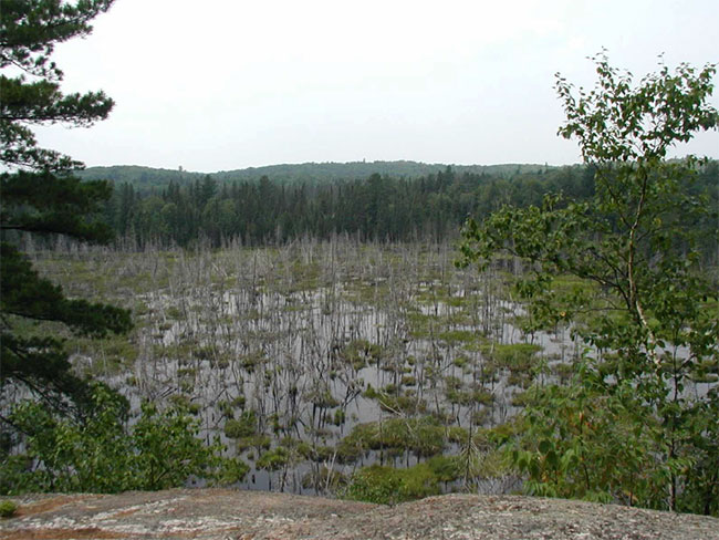
Photo 2: View of cottage road that originates from Northshore Road leading to a private camp.
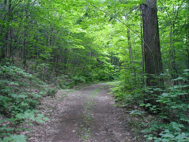
Photo 3: View of OFSC Club Trail WN 403 located inside Field Township Conservation Reserve
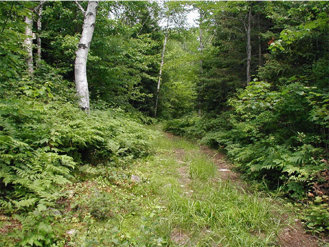
Photo 4: Additional view of OFSC Club Trail WN 403 located inside Field Township Conservation Reserve
Appendix 1 - Procedural guideline B – land uses – Test of Compatibility (PL procedure 3.03.05)
The Conservation Reserve policy provides broad direction with regard to the permitted uses. The policy provides only an indication of the variety of uses that will be considered acceptable in conservation reserves. The only caution is that "any new uses, and commercial activities associated with them, will be considered on a case by case basis, and, they must pass a test of compatibility to be acceptable." What does a 'test of compatibility' mean?
An examination of this must start from the premise of why an area is set aside – specifically, its representative natural heritage values. Criteria are then identified to guide compatibility considerations. These criteria apply to the long-term acceptability of both existing uses and new uses.
-
Conformity to SCI/RMP: SCI describe values for which an area has been set aside and the range of appropriate uses that will be permitted in the area. SCI may also speak to the acceptability of other 'new' uses currently not occurring in the area.
The first 'test' is: "do proposed new land uses and/or commercial activities conform to the direction of the SCI/RMP for the conservation reserve? Would the new use(s) depart from the spirit of appropriate indicator land uses in the SCI/RMP?"
- Impact Assessment: If the proposed use(s) pass test 1 it is important to determine their impact on the area before they are approved. This should include the following:
- Impact on natural heritage values: "will the new use(s) impact any natural values in the area? If so how and to what degree? Is it tolerable?"
- Impact on cultural values: "will the new use(s) impact an historical or archaeological values in the area?"
- Impact on research activities: "will the new use(s) affect research activities in the area?"
- Impact on current uses: "will the new use(s) have any negative impact on the array of current uses?"
- Impact on area administration: "will the new use(s) increase administrative costs and/or complexity?" (For example, the cost of area monitoring, security and enforcement).
- Impact on accommodating the use outside the conservation reserve: "Could the use(s) be accommodated as well or better outside the conservation reserve?"
- Impact on socio-economics of the area: "will the new use(s) affect the community(ies) surrounding the area in a positive or negative way?" (For example, will the new use make an area less remote thereby affecting a local tourism industry that is dependent on the area’s remoteness for its appeal?"
- Impact on area accessibility: "does the new use(s) give someone exclusive rights to the area or a portion of the area to the exclusion of other existing uses?"
Appendix 2 - Public Lands Act policy (3.03.05) Conservation Reserve Permitted Use table
Indicator uses for Conservation Reserves
Recreation
| Permitted activities | Generic Existing/New |
(C167) Specific New Uses |
|
|---|---|---|---|
| Sport fishing | Yes | Yes | Yes |
| Sport hunting | Yes | Yes | Yes |
| Food gathering | Yes | Yes | Yes |
| Facility infrastructure | Maybe | Maybe | Maybe1 |
| Non-trail snowmobiling | Maybe1 | Maybe1 | Maybe2 |
| Non-trail ATV use | Maybe1 | Maybe1 | Maybe2 |
| Rock climbing/caving | Maybe | Maybe | N/A |
| Canoeing/kayaking | Yes | Yes | Yes |
| Motorized boating | Yes | Yes | Yes |
| Picnicking | Yes | Yes | Yes |
| Camping | Maybe | Maybe | Yes |
| Trails: | Yes | Maybe | Maybe1 |
| Trails: Hiking | Yes | Maybe | Maybe1 |
| Trails: X county skiing | Yes | Maybe | Maybe1 |
| Trails: Cycling | Yes | Maybe | Maybe1 |
| Trails: Horse riding | Yes | Maybe | Maybe1 |
| Trails: Snowmobiling | Yes | Maybe | Maybe1 |
1 New uses will be considered on a case by case basis provided they do not impact the natural heritage values for which the area was established, and must pass a test of compatibility to be acceptable.
2 For retrieval of game only
Science, education & heritage appreciation
| Permitted activities | Generic Existing/New |
(C167) Specific New Uses |
|
|---|---|---|---|
| Research | Yes | Yes | Yes |
| General walking | Yes | Yes | Yes |
| Photography and painting | Yes | Yes | Yes |
| Wildlife viewing | Yes | Yes | Yes |
| Outdoor education/interpretation | Yes | Yes | Yes |
| Collecting | No | No | No |
Commercial activities
| Permitted activities | Generic Existing/New |
(C167) Specific New Uses |
|
|---|---|---|---|
| Food harvesting | Maybe | Maybe | No |
| Fishing | Maybe | Maybe | No |
| Baitfish harvesting | Yes1 | Maybe | Maybe |
| Trapping | Yes1 | Maybe | Maybe |
| Trap cabins | Yes | No | No |
| Resort-outpost camp | Yes1 | No | No |
| Outfitting-bear management | Yes1 | No | Yes |
| Wild rice harvesting | Yes | Maybe | N/A |
1 Transfer requests will be considered in the context of a Statement of Conservation Interest (SCI) or Resource Management Plan (RMP) for each conservation reserve.
Resource management
| Permitted activities | Generic Existing/New |
(C167) Specific New Uses |
|
|---|---|---|---|
| Inventory monitoring | Yes | Yes | Yes |
| Featured species management | Maybe | Maybe | Maybe |
| Natural systems management | Maybe | Maybe | Maybe |
Industrial activities
| Permitted activities | Generic Existing/New |
(C167) Specific New Uses |
|
|---|---|---|---|
| Timber harvesting | No | No | No |
| Prospecting | No | No | No |
| Mining | No | No | No |
| Hydro generation | No | No | No |
| Energy transmission corridors | Yes | No | No |
| Communications corridors | Yes | No | No |
| Transport corridors | Yes | No | No |
| Resource roads (MNR) | Yes | No | No |
| Land disposition | * | No | No |
| Hunt camps | Yes1 | No | No |
* Existing dispositions will continue, however, as opportunities arise the Ministry will acquire and/or remove them outside of the conservation reserve.
1 Transfer requests will be considered in the context of a Statement of Conservation Interest (SCI) or Resource Management Plan (RMP) for each conservation reserve.
Appendix 3 – boundary amendment for Field Township Conservation Reserve
Amendment Form: 2002_06
Amendment form for MNR Land Use Direction
Information on amendment processes including specific guidelines for the completion of this form, are outlined in "Procedures for the Amendment of MNR Land Use Direction".
Amendment Number [assigned by Land Use Coordination Section]: 2002 - 06
Amendment Status: Approved
Amendment Short Title [assigned by Land Use Coordination Section]: Revisions to Field Township Conservation Reserve (C167)
1. Amendment proposed by [To be completed by originato Personal information will not be made publicly available.]
Name of Individual or Group: Sally Renwick, District Planner, North Bay
Address:
3301 Trout Lake Road,
North Bay, ON P1A 4L7
Phone Number: 705-475-5533
Fax Number: 705-475-5500
E-mail address: sally.renwick@mnr.gov.on.ca
Date: August 14, 2002
2. Classification of amendment [originator to indicate recommended categories and area affected]
Area-Specific Policies
Minor Amendment
Describe area potentially affected (for proposed area-specific amendments)
The proposed amendment is to change the proposed boundary of the Field Township Conservation Reserve (C167). The area potentially affected is Crown lands in the geographic township of Field within the Municipality of West Nipissing. The lands are within MNR's North Bay administrative district.
3. Specific amendment proposed [to be completed by originator]
Provide the proposed text of amendment, or summary of the intent of the amendment.
Include a map of the proposed amendment if applicable:
The changes to the Land Use Strategy / Crown Land Use Atlas would be as follows:
- Appendix A of Land Use Strategy, page 82 for this area would be amended to reflect the change in area, from 191 ha to 399 ha.
- Map 3 in the Land Use Strategy would be amended to reflect the new boundary.
The values within the site have not changed and the area description remains the same.
The area identified in the Land Use Strategy, 191 ha, was based on broad scale mapping. Refined mapping and analysis resulted in a proposed area of 369 ha. Further review and analysis, including the exclusion of the landfill site and attenuation zone and the identification of replacement area, resulted in an area of 423 ha. Boundary refinement consultation resulted in a final size of 399 ha.
4. Need for amendment and analysis [to be completed by originator]
Provide a summary of why the amendment is being proposed, the anticipated benefits and impacts, public implications, etc.:
During the Lands for Life and Ontario’s Living Legacy planning processes, values within this site were identified using computer-generated gap analysis, and were put forward as a proposed conservation reserve. During planning, a landfill site located within the proposed conservation reserve was not identified.
The landfill is located on Crown land and has been held by the Municipality of West Nipissing for 25 years under authority of a Land Use Permit. The municipality has expressed a strong desire to acquire the landfill site and attenuation zone.
It is in MNR's interest to divest itself of the liability associated with this landfill site by selling the landfill site and attenuation zone to the municipality. In the early 1990's, MNR wrote to the municipality at that time offering to sell the landfill site to them. The district would like to uphold a commitment to transfer the ownership of the land to the municipality. This commitment was made prior to the March 1999 release of the draft Land Use Strategy. The approved Land Use Strategy states that "in implementing the new land use policies, consideration needs to be given to existing commitments" and "subject to meeting all other ministry requirements, the Ministry will complete transactions where a commitment has been established" (page 20).
The Ministry is proposing to modify portions of the boundaries of the Field Township Conservation Reserve (C167) from those boundaries contained in the Land Use Strategy. The modification would still maintain the minimum threshold vegetation/landform representation for which the site was identified. The proposed changes are shown on the attached map.
The proposed boundary of the conservation reserve would be amended to exclude an area in the south east portion of the site and add new area to the south. The area to be excluded, a landfill site and attenuation zone not identified during planning, is 151ha in size. Ownership of this land would be transferred to the Municipality, upholding an existing commitment from MNR.
Although the intent of the conservation reserve is the same, excluding this area from the site is beyond boundary fine-tuning and requires a minor amendment to the Land Use Strategy / Crown Land Use Atlas.
5. Screening of amendment [to be completed by MNR coordinating office]
Date proposed amendment received by Ministry of Natural Resources [applicable only to external amendment requests]: dd / mm / yy
Decision on Classification of Amendment (indicate where a determination has been made that the classification should be different from what was originally outlined in section 2 of this form.):
Screening decision and rationale (indicate which of the five screening categories the amendment has been assigned to and rationale):
Screening decision: The proposed amendment warrants detailed consideration and the review process should be initiated.
Amendment classification Decision: Minor Amendment - area specific
Recommend that consultation proceed in conjunction with consultation for boundary refinement. As per the districts analysis, the proposed amendment is consistent with the Ministry’s position stated in an Information Briefing Note submitted in December 2001. Pre-consultation on this amendment indicates that it is not expected to be contentious. It complements the original intent of the Land Use Strategy, and does not have a negative affect on the public or adjacent land owners.
Screening decision made by [name, title]:
Rob Galloway,
Regional Director,
Northeast Region
Date: 30 / 08 / 02
Date screening decision sent to originator [applicable only to external amendment requests]:
6. Public consultation [to be completed by MNR coordinating office for amendment proposals that proceed after the initial screening]
Describe the scope of public consultation that was carried out, including the rationale for the consultation approach. (Where consultation has occurred as part of a separate planning process that is adequately documented elsewhere, refer to the existing documentation):
Public consultation on the proposed LUS amendment took place concurrent with boundary refinement consultation for proposed Field Township Conservation Reserve. The formal consultation period occurred from September 16, 2002 to October 16, 2002. This included direct notification by mail to all adjacent property owners identified in tax assessment records, Nipissing Forest Local Citizen Committee members and other known stakeholders with an interest in this area. Advertisements were placed in the Almaguin News, Mattawa Recorder, North Bay Nugget, Sudbury Star, Le Voyageur, Sturgeon Falls Tribune and Temiskaming Speaker. Consultation with local First Nations, Ministry of Northern Development and Mines, the holder of the Sustainable Forest Licence in the area and the Partnership for Public Lands also occurred.
Summary of Public Input (Where there is adequate documentation elsewhere, e.g., EBR decision notice, refer to the location of the documentation):
No public comments related to the proposed amendment were submitted. General comments related to boundary refinement are on file at the district office. A decision notice will be placed on the EBR registry.
7. Decision on the proposed amendment [to be completed by MNR coordinating office]
Outline of MNR decision including rationale:
Decision is to proceed with the amendment. The rationale is provided in section four of this form.
Amendment approval
Approved by [name, title]:
Rob Galloway,
Regional Director,
Northeast Region
Date of Approval: 06 / 02 / 03
Date amendment comes into force (if different than date of approval): dd / mm / yy
Exact text of the amendment (where approved):
Since this amendment was first proposed, the Crown Land Use Atlas has been launched as the provincial land use planning tool. Area specific amendments to the Land Use Strategy will now be treated as amendments to the Crown Land Use Atlas. The following revised text should be used to amend the Atlas; specifically, the revision should be made to the Policy Report C167 for Field Township Conservation Reserve:
Type Text Here: Area (ha): 399 (Note: the Atlas already reports site area as 369)
The following map shows the original and revised boundary for C167, Field Township Conservation Reserve. Note that polygon mapping of this CR to be used in the Atlas will be provided through other channels once the site is regulated.
Enlarge Field Township Conservation Reserve (C167) map.
8. Communication of decision [to be completed by MNR coordinating office]
Describe how the decision will be communicated [Proposed communication should be identified after the screening process has determined that a proposed amendment will receive further review. - see section 5. If necessary, this should be revised after the final decision.]:
Communication of the decision will include posting a decision notice on EBR registry and by mailout to adjacent landowners and interested stakeholders during notification of site regulation.
The personal information included on this form is collected under the authority of the Public Lands Act in order to make decisions about managing public lands in Ontario. Release of personal information submitted on this form is governed by the Freedom of Information and Protection of Personal Privacy Act. All proposed amendments to MNR's land use direction will become a part of the permanent public record.
Appendix 4 – Glossary of terms
- Biotite
- A generally black or dark green form of mica that is from crystalline rocks and consists of a silicate of iron, magnesium, potassium, and aluminum3
- Cultural Heritage
- Collective term describing examples of a society’s evolution (e.g. history, anthropology and archaeology) worthy of study and preservation5
- Cultural Resources
- Sites, features or artifacts related to the Province’s archaeology, anthropology or history, preserved in a natural setting5
- Ecodistrict
- An ecological landscape unit (ranging in resolution in hundreds of square kilometers) characterized by a distinct patterns in landform8
- Ecoregion
- An ecological landscape unit (ranging in resolution from hundreds of thousands to tens of thousands of square kilometers) characterized by distinct patterns of responses to climate as expressed by soils, hydrology, vegetation (species ranges and productivity), and fauna7
- Glaciolacustrine
- Material ranging from fine clay to sand derived from glaciers an deposited in glacial lakes by water originating mainly from the melting of glacial ice. Many are interbedded or laminated1
- Gneiss
- A crystalline rock, consisting, like granite, of quartz, feldspar, and mica, but having these materials, especially the mica, arranged in planes, so that it breaks rather easily into coarse slabs or flags2
- Greywackes
- Any of various dark gray sandstones that contain shale2
- Knob
- Small prominent rounded hill or mountain of glacial drift9
- Lacustrine
- Of or relating to lakes2
- Moraine
- A knobby ridge either of (a) boulder clay built or by a thrust of a glacier or of (b) gravel and sand deposited at the edge of glacier escaping meltwater4
- OBM
- Ontario Base Map, refers to a geographic division of Ontario according to lines of longitude into mapsheets based on the UTM map projection system6
- Patent
- An exclusive right or title2
- Sedimentary
- Of or relating to rocks formed by the deposition of sediment2
- Understory
- An underlying layer of vegetation, especially the plants that grow beneath a forest’s canopy2
- UTM
- Universal Transverse Mercator4
Figure 1: location of Field Township Conservation Reserve
Enlarge Figure 1: location of Field Township Conservation Reserve map.
Figure 2: forest values map of Field Township Conservation Reserve
Enlarge Figure 2: forest values map of Field Township Conservation Reserve map.
Figure 3: recreational values & tenure map of Field Township Conservation Reserve
Enlarge Figure 3: recreational values & tenure map of Field Township Conservation Reserve map.
1http://www.onlakepartners.org/acrogloss/dsp_workpopup.cfm?word_id=185.
2Dictionary.com. 2003. Lexico Publishing Group. www.dictionary.com
3Merriam – Webster. 2002. Merriam – Webster Online. www.m-w.com
4Chapman, L.J, and D.F. Putnam. 1984. The Physiography of Southern Ontario, Third Edition. Ontario Geological Survey
5OMNR. 1992. Ontario Provincial Parks: Planning and Management Policies: 1992 Update. OMNR
6OMNR. 2001. Glossary.http://www.mnr.gov.on.ca/mnr/forests/forestdoc/ebr/fimpdfs/glossary.pdf (Link no longer active).
7OMNR. 1996. Forest Management Planning Manual. Toronto: Queen’s Printer for Ontario
8Crins, William J and Peter W.C. Uhlig. 2002. Ecoregions of Ontario: Modifications to Angus Hills' Site Regions and Districts Revisions and Rationale.
9Strahler, Alan and Arthur Strahler. 1997. Physical Geography Science and Systems of the Human Environment