Finlayson Point Provincial Park Management Plan
This document provides direction on the management of Finlayson Point Provincial Park.
Park management planning series
April 15, 1986
ISBN 0-7729-0495-2
1985 Government of Ontario
Additional copies of this publication are obtainable from the Ministry of Natural Resources, Temagami District Office, P.O. Box 38, Temagami, Ontario, P0H 2H0, Telephone (705) 569- 3622.
Price: $2.00 (Tax Included)
Foreword
We are pleased to approve the Finlayson Point Provincial Park Management Plan, as official policy for the management and development of this Park. The plan reflects this Ministry’s intent to protect natural features of the Finlayson Point Provincial Park and maintain high quality opportunities for outdoor recreation and heritage appreciation for both residents of Ontario and visitors of the Province.
M.A. Klugnian
Regional Director
Northeastern Region
Norm Richards
Director
Parks and Recreation Areas Branch
1. The Park
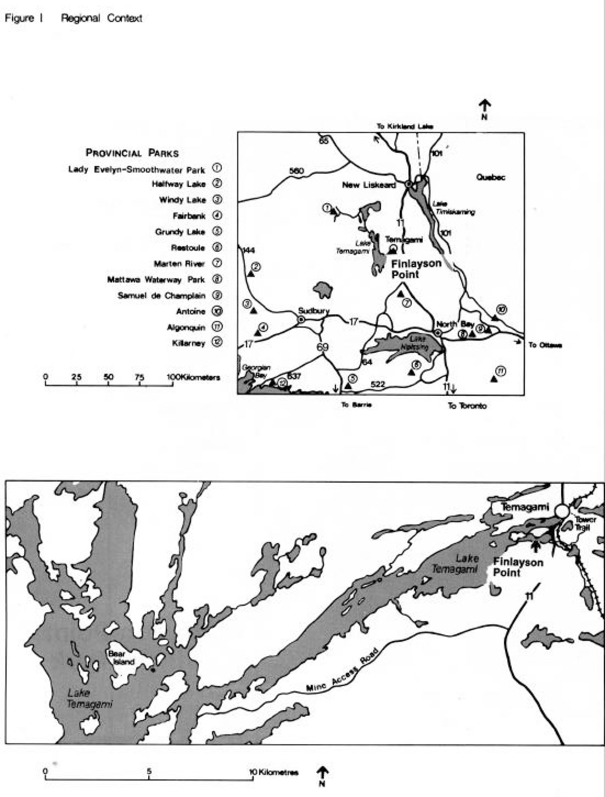
Finlayson Point Provincial Park is located 1 km south of the town of Temagami adjacent to Highway 11 (see Figure 1). The Park is within a one hour drive of North Bay and the Tri-Towns (New Liskeard, Haileybury, Cobalt). Development of the Park began in the late 1920's as a small highway campground. The area received Park status in 1963.
The landscape of this 37 ha Park is a hilly series of rock ridges. A thin soil veneer of well-drained silty sand covers the bedrock throughout most of the Park. The forest cover varies depending on soil and moisture conditions. The prominent species are old, tall, white and red pines along the rocky shoreline and scattered throughout the campground. Two small wetlands occur in the Park.
Finlayson Point provides a variety of recreational opportunities including camping, picnicking, boating, fishing, and swimming. The Park serves as a 'stopover' point for visitors vacationing in the Lake Temagami area.
2. Park policies
2.1 Classification
Finlayson Point has been designated a recreation park because of its significant recreational setting, being situated on Lake Temagami, and because of its potential for recreation development. The area has traditionally been used for recreation by both local residents and travelers. The small size of the Park and the extent of facility development already in place precludes another designation.
2.2 Goal
Recreation Parks are areas, which support a wide variety of outdoor recreation opportunities for large numbers of people in attractive surroundings. Recreation Parks contribute principally to the achievement of the recreation, heritage appreciation, and tourism objectives.
2.3 Objectives
Protection
Although there are no provincially significant natural or cultural features within Finlayson Point, a basic objective will be to maintain the natural features, which now exist. Management programs will be implemented to improve the natural attributes of the campground and park entrance. New development proposals will be carried out with minimum impact on the park’s natural resources.
Recreation
"To provide outdoor recreation opportunities ranging from high intensity day use to low intensity wilderness experiences."
Park operation will continue to provide 5,000 day use opportunities and 31,300 car camping opportunities annually. Planning evaluations for the Temagami District Land Use Guidelines determined that additional opportunities will not be required for the next 20 years.
Figure 1: Regional Context

Enlarge Figure 1: Regional Context
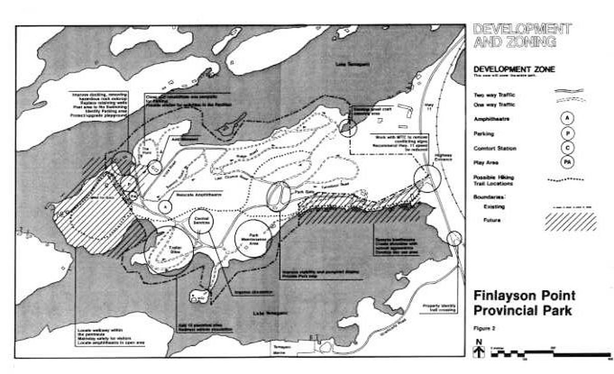
Figure 2: Development and Zoning
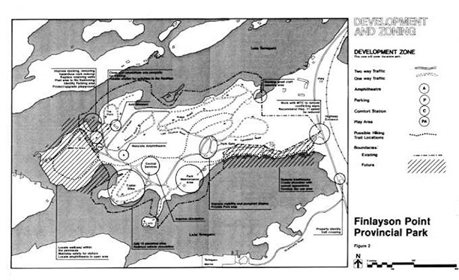
Enlarge Figure 2: Development and Zoning
Heritage appreciation
"To provide opportunities for exploration and appreciation of the outdoor natural and cultural heritage of Ontario."
The Park will offer structured opportunities for visitors to appreciate the natural and cultural features of the area. The Park will continue to serve as a central point for interpreting natural and cultural themes in the Temagami area.
Tourism
"To provide Ontario’s residents and out-of-province visitors with opportunities to discover the experience of the distinctive regions of the Province."
Tourists travelling Highway 11 will continue to use Park facilities. Through the guidance of the Park marketing plan, complementary area tourism marketing will promote the Temagami experience to Park visitors.
2.4 Boundary
The Park occupies a portion of a peninsula in Lake Temagami. Crown land and private property adjoin the Park on the east, west, and south sides. A small Park area (37 ha) and intensive recreation use on these lands result in congestion of activities. This detracts from Park visitor’s experiences and can interfere with services for permanent residents.
Two areas of Crown land will be added to the Park. These areas include the Air Base property on the west side of the Park and the area of the boathouses on the southeast side of the Park.
2.5 Zoning
One development zone will guide the management of this Park. (See Figure 2.) This will include the two areas of Crown land, which will be added to the Park in the future.
This zone is fully developed to provide day use and car camping opportunities require d in the area.
3. Resource management
The Park’s small land base is highly developed and intensively used. Large, white and red pines are important aspects of the Park environment as they contribute to the recreational setting.
3.1 Vegetation
Deterioration of the forest cover has resulted from a variety of causes including direct removal of vegetation, disturbance of ground cover and soil compaction by vehicle and foot traffic, which leads to soil erosion.
Ongoing rehabilitation is required to ensure that vegetation and soils are not further impaired by use. A vegetation management plan will identify appropriate measures to rehabilitate a healthy forest cover in the Park.
4. Client services
Located on the edge of a vast lakeland with recreation and tourism potential, the Park serves a wide clientele. It complements other recreation and tourism developments.
4.1 Park identity and image
The present name of the Park does not adequately identify the park as it relates to the setting out Lake Temagami. Request for approval will he submitted to have the name changed to Lake Temagami Provincial Park.
4.2 Visitor services
An important aspect of the Park program objectives can be achieved by providing information to the public on resource management and recreation skill development associated with the Lake Temagami area.
4.2.1 Communication
Information concerning Park resources, management, facilities, programs, and nearby points of interest will be made available to the general public.
This information will be disseminated at key points throughout the Park such as the gatehouse and pavilion, and on Park bulletin boards.
4.2.2 Interpretation
Interpretive programs provide the opportunity to create a greater understanding of the natural, cultural, and recreational values of the Park and surrounding area.
Through personal contact, interpretation of these values will be achieved by making use of facilities such as the pavilion and amphitheater. Generally, programs will be geared to self-use facilities. Recreational opportunities such as boating, canoeing, fishing and hunting, as well as resource related activities such as forestry, mining, and trapping will be emphasized.
4.2.3 Education
The Park provides an excellent opportunity for groups to make use of the outdoors for educational purposes.
The Park will continue to encourage groups or individuals to use the Park resources for educational purposes, which are compatible with Park policy and protection guidelines. Park staff will provide assistance with these programs when possible.
4.2.4 Marketing
Most campers stay at the Park for 1 or 2 days. The campground occupancy in 1983 was 49 percent and in 1982 was 5 percent, which indicates that there is room for increasing visitation.
The approved marketing plan (1980) will be implemented. It will stress the variety of recreation and tourist opportunities to experience Finlayson Point. Ways to increase the appeal of the campground and day use area that encourage longer stays by visitors will be discussed in the following section.
5. Development
Development will proceed in accordance with Figure 2 and the following guidelines. The general theme of Park development will concentrate on visitor safety and the improvement of recreation facilities and services. Site Plans will be completed and approved in advance of the rehabilitation of existing facilities. Development projects will be phased according to the Plan’s Implementation and Review Section. The requirements of the Environmental Assessment Act will be followed.
5.1 Visitor safety
The following measures will be undertaken to improve visitor safety.
5.1.1 Traffic flows and gate house
This facility, located 500 m from Highway 11, is the first contact with Park visitors. The prospective visitor travels this distance and encounters one dangerous curve, two secondary roads, and circulation problems at the gatehouse itself.
The distance to the gatehouse will be indicated on a sign along the road just after the Park entrance sign. The dangerous curve before the MNR residence will be straightened. Secondary roads for non Park use will he signed accordingly. Campground and day use traffic flows will be improved by providing some one way roads and a consistent sign system based on the MNR Sign Design Guidelines. In this way, traffic pressure should be relieved where pedestrians congregate and at vehicle intersections (e.g. Last Chance, Turnabout and Ridge Roads).
The gatehouse will be remodeled to provide an adequate view of approaching traffic. Realignment of the road at the gatehouse will improve traffic flow and safety.
Visitor traffic will be directed away from the boat basin/swimming area.
5.1.2 Boat basin/swimming area
The activities of park visitors launching boats, day use swim ming and Lake Temagami boating traffic sometimes conflict with one another.
Car parking in the area will be redesigned to separate congestion with incoming and outgoing traffic and pedestrian use. The playground will be separated by natural barriers (e.g. vegetation, rock) from vehicle traffic. Day use swimming will be phased out of this site when a suitable alternate location can be developed.
5.2 Recreational facilities and services
High quality recreational facilities and services will be maintained. Provincial Park operating standards will be implemented through annual work program planning.
5.2.1 Picnic and playground areas
These facilities are near the main Park road and the MNR Air Base. The existing structures require upgrading.
Natural barriers will be installed to separate these areas from vehicular traffic. All structures in these areas will be maintained to keep them sound. The space will be kept uncluttered to ensure room for expansion as demand warrants.
5.2.2 Trailer sites
The layout of these sites can result in hazardous entrance and exit from campground roads. Visitors continually request electrical hookups.
A site plan will be prepared for these sites to redesign entrance and exit lanes. Electrical hookups will be identified as an upgraded service requirement to enhance use of the campground.
5.2.3 Parking
Existing parking facilities are limited in the campground and day use areas. Aside from the Boat Basin lot, other areas are quite restricted.
Where possible, existing parking lots will be redesigned to efficiently use available space. Parking will be provided adjacent to the pavilion for the use of its visitors.
5.2.4 Pavilion
This building has been converted from a picnic shelter to serve a wider purpose. Situated overlooking the northeast arm of Lake Temagami, it is a vantage point for visitor services programming and an area museum.
The pavilion will continue to be used as an interpretive centre and museum. Winter use will be encouraged to shelter activities in the Park (e.g. cross-country skiing).
5.2.5 Amphitheater
The facility is located in a wooded area adjacent to a wetland. In this situation, limited air circulation results in an abundance of insects.
An alternate site will be sought to improve the setting of this facility.
The new location will be more suited to provide an open setting where air circulation reduces insect problems. A site plan will be prepared.
5.2.6 Boat basin
This small cove is the focal point for several activities Boat launching and dockage, swimming, sunbathing, and relaxation.
A retaining wall and docks are in need of repair, and during seasonally low water levels, use is restricted by shallow water over a rock shoal.
Priority for use will be given to boating needs. The dock and retaining wall will be upgraded. The feasibility of removing rock from the shoal will be examined. Alternate areas for day use swimming will be examined to relocate this activity to a safer location. Once a suitable alternate site is found the basin will be posted to "No Swimming".
5.2.7 Small craft mooring area
This area was previously developed as a wading pool. The area has problems with infilling by emergent and submergent aquatic plants, poor sun exposure, proximity of a Park road, and a lack of demonstrated use. A site plan will be prepared to develop a small craft mooring area for Park visitor’s power and sailboats.
Pool structures will be removed from the cove. This will take some pressure off the boat basin docking demands. Aquatic growth will naturally be reduced by opening up lake currents to the bay.
5.2.8 Comfort station
The need for showers in the Park was the most common visitor comment reported in previous surveys.
Showers are recommended for the Park. The sewage disposal capability of the comfort station will be assessed prior to submitting a funding proposal. Should it not be capable of handling this additional activity, alternate sites will be studied.
5.2.9 Central services area
Facilities in the area include a wood yard, trailer filling station, trailer pump out, and a central garbage disposal. The location of these services opposite the trailer sites along the main access road is suitable. The space taken up by the facilities is excessive due to poor layout and ambiguous circulation.
The layout of these facilities will be redesigned with a site plan to reduce the space that they take up, and a clear circulation pattern will be established. Additional trailer dumping facilities may be needed here should pre sent levels of use increase.
6. External land uses
Development and intensive uses occur on Crown and private land outside, but adjacent to the Park boundary. Although external to the Park, these uses can cause Park management and operational problems.
6.1 Adjoining crown lands
Crown lands east, south, and west of the Park are used for a variety of government and private individual’s purposes. Two areas of Crown land will be added to the Park.
6.1.1 Air base
An MNR floatplane and helicopter base will be maintained at the extreme west end of the Park. The remainder of the point will be added to the Park. A walking trail will be developed in this area. The open areas east of the Air Base will be evaluated as a possible location for relocating the amphitheater.
These improvements will enhance recreation, tourism, and heritage appreciation objectives of the Park by enabling visitors to experience a natural setting not congested by other uses.
6.1.2 Land use permits for private boat houses
Boat houses, visible from Highway 11 and south of the entrance road before the gatehouse, conflict with the visitor’s image of a Park being public land, even though the boathouses are on Crown land outside the Park. Some of the boathouses are unsightly to potential Park visitors. As well, the Land Use Permits tie up valuable waterfront land adjacent to the Park that could be used for activities: swimming, picnicking, boat launching, and docking. Alternate facilities for boat launching and storage are readily available nearby.
The Land Use Permits for boathouses will not be renewed after September 30, 1990. This will enable MNR to return the area to a more natural setting with the intent of adding it to the Park. A site plan will be prepared prior to developing the area .
6.1.3 Pedestrian access along highway 11 to the park
Located just one kilometer south of Temagami, it is convenient for people to walk or bicycle along Highway 11 to the Park.
To reduce potential hazard to persons who would walk or bicycle into the Park, MNR will work with the Ontario Ministry of Transportation and Communications to reduce the highway speed in this area and have it posted with MTC "Watch for Pedestrians" signs.
6.1.4 Hiking trail east of highway 11
The Caribou Tower Trail on Crown land east of the Park is being developed to provide a route to a high viewpoint over Lake Temagami.
The concept plan for Crown lands presently occupied by Land Use Permits will include a trail from the Park to the Caribou Tower Trail. Signs will caution hikers of the highway crossing. The Caribou Tower Trail will be completed.
6.2 Adjoining private lands
6.2.1 Trail on private land
A trail has been developed on private land occupied by a motel east of the Wading Pool area. This trail will be discontinued at the Park, and Park visitors will be discouraged from using it.
6.2.2 Access to private residence
A private residence on the south shore uses the Park road for access. This access will be discontinued. The resident will be instructed to use the Park service road.
7. Plan implementation and review
Implementation of this management plan will be based on work program planning and operating plan and the following priorities.
7.1 Priority 1: Short term implementation
7.1.1 Resource management
- vegetation management planning to identify ongoing planting needs and rehabilitation measures.
7.1.2 Client services
- pursue name change approval;
- continue to follow Park marketing plan;
- prepare an area visitor services plan to maximize contact with Park visitor to inform them about attractions in the Lake Temagami area;
- provide programs at the amphitheater and pavilion.
7.1.3 Development
- upgrade signs throughout the park;
- remove dangerous curve on entrance road;
- realign present road circulation by providing some one- way traffic areas;
- prepare a site plan for the Central Services Area;
- prepare a site plan for the Boat Basin area to separate potentially conflicting uses;
- evaluate Crown land on south shore for an alternate day use swimming area;
- prepare a site plan for Wading Pool cove as a boat mooring area;
- replace deteriorated picnic and playground facilities adjacent to Boat Basin, buffer area from road traffic;
- continue to use the pavilion as a Park interpretive centre and area museum and provide day use parking here by phasing out one adjoining campsite.
7.1.4 External land use
- prepare a trail plan integrating natural and scenic areas of Park and adjoining Crown land;
- discontinue trail from private land east of Park;
- the private residence south of the Park will continue to use the Park entrance road;
- consult with MTC to reduce Highway 11 traffic speeds between Temagami and the Park and post "Watch for Pedestrians" signs to encourage safe pedestrian and bicycle use to the Park;
- land Use Permits for boat houses on Crown land south of the Park will not be renewed as of September 30, 1990, all improvements on these lands will be removed before the area is added to the Park;
- the Park boundary will be changed to regulate Crown land west of the Park, excluding the Air Base, as well as the Crown land previously held as Land Use Permits for boat houses south of the Park.
7.2 Priority 2: Long term improvement
7.2.1 Development
- remodel gate house and road circulation here to ensure clear viewing by gate attendants and motorists;
- expand existing car parking capacity in the campground and day use areas by first upgrading existing parking areas and second by providing new areas adjacent to the Boat Basin as needs warrant;
- install showers in comfort stations;
- prepare site plan for the trailer sites in the campground redesigning entrance and exit lanes and examining the feasibility of developing some electrical sites.
7.2.2 External land uses
- when the area which is pre sently held in land use permits for boat houses is reclaimed and that Crown land is added to the park, it will be evaluated through site planning to provide swimming, picnicking, boat launching and docking, as well as trail linkage for the Caribou Tower Trail;
- initiate site planning for Crown land west of the Park to the Air Base once it has been added to the Park.
7.3 Plan review
The Finlayson Point Provincial Park Management Plan will be reviewed at a minimum of over ten years or as the need is determined by the Regional Director. The review will be conducted in the following manner:
- review of the process leading to the initial management plan;
- update of background information and data about the Park resources and use;
- review of the status of implementation of the approved management plan and provincial policies;
- identify OMNR, other agencies, and public issues of concern; prepare issues and suggested solutions document for public review;
- review proposed revisions recommended by the public;
- prepare and receive approval for plan amendment.
8. Public consultation
This Park Management Plan is a result of a continuing consultation process that has considered the needs, desires, and opinions of a variety of interests. It marks an attempt to achieve balance economically, socially, and environmentally in our approach to the management of Finlayson Point Provincial Park for both now and in the future.
Public involvement in the management plan first began during the spring of 1984 with news releases requesting public participation in two open house presentations scheduled for the coming summer. These presentations were maintained from mid June to early September at the Park and the Temagami District Office. In February of 1985, copies of the preliminary management plan were mailed directly to interest groups, other government ministries, and adjacent property owners. They were requested to submit within 30 days any comments regarding the management plan to the District Manager at Temagami. Copies of all comments received are available for viewing at the Temagami District Office.
In applying this Park Management Plan, our Ministry is committed to continuing this consultation with government agencies, other ministries, interest groups, and the public. It is important that the channels of communication that have been created by this consultation process be kept open.
Selected references
Dobbin J. Assoc. Ltd., J.E. Hanna Assoc. Ltd., P. Bernard Assoc. Ltd., Finlayson Point Provincial Park Management and Site Development Plan, Toronto: 1982.
Ontario Ministry of Natural Resources Car Camping and Day Use Survey for Finlayson Point Provincial Park, OMNR, Toronto: 1979.
Ontario Ministry of Natural Resources Ontario Provincial Parks Planning and Management Policies, OMNR, Park Planning Section, Toronto 1978.
Ontario Ministry of Natural Resources Temagami District Land Use Guidelines, OMNR, Temagami: 1983.