Forked Three-awned Grass Recovery Strategy
This document advises the ministry on ways to ensure healthy numbers of the forked three-awned grass, a threatened or endangered species, return to Ontario.
Ontario Recovery Strategy Series
Recovery strategy prepared under the Endangered Species Act, 2007
February 2011
About the Ontario recovery strategy series
This series presents the collection of recovery strategies that are prepared or adopted as advice to the Province of Ontario on the recommended approach to recover species at risk. The Province ensures the preparation of recovery strategies to meet its commitments to recover species at risk under the Endangered Species Act, 2007 (ESA, 2007) and the Accord for the Protection of Species at Risk in Canada.
What is recovery?
Recovery of species at risk is the process by which the decline of an endangered, threatened, or extirpated species is arrested or reversed, and threats are removed or reduced to improve the likelihood of a species' persistence in the wild.
What is a recovery strategy?
Under the ESA, 2007, a recovery strategy provides the best available scientific knowledge on what is required to achieve recovery of a species. A recovery strategy outlines the habitat needs and the threats to the survival and recovery of the species. It also makes recommendations on the objectives for protection and recovery, the approaches to achieve those objectives, and the area that should be considered in the development of a habitat regulation. Sections 11 to 15 of the ESA, 2007 outline the required content and timelines for developing recovery strategies published in this series.
Recovery strategies are required to be prepared for endangered and threatened species within one or two years respectively of the species being added to the Species at Risk in Ontario list. There is a transition period of five years (until June 30, 2013) to develop recovery strategies for those species listed as endangered or threatened in the schedules of the ESA, 2007. Recovery strategies are required to be prepared for extirpated species only if reintroduction is considered feasible.
What’s next?
Nine months after the completion of a recovery strategy a government response statement will be published which summarizes the actions that the Government of Ontario intends to take in response to the strategy. The implementation of recovery strategies depends on the continued cooperation and actions of government agencies, individuals, communities, land users, and conservationists.
For more information
To learn more about species at risk recovery in Ontario, please visit the Ministry of Natural Resources Species at Risk webpage.
Recommended citation
Jones, J.A. 2011. Recovery Strategy for the Forked Three-awned Grass (Aristida basiramea) in Ontario. Ontario Recovery Strategy Series. Prepared for the Ontario Ministry of Natural Resources, Peterborough, Ontario. ii + 18 pp. + Appendix vii + 25 pp.
© Queen’s Printer for Ontario, 2011
ISBN 978-1-4435-4956-1 (PDF)
Content (excluding the cover illustration) may be used without permission, with appropriate credit to the source.
Cette publication hautement spécialisée Recovery strategies prepared under the Endangered Species Act, 2007, n'est disponible qu'en anglais en vertu du Règlement 411/97 qui en exempte l'application de la Loi sur les services enfrançais. Pour obtenir de l'aide en français, veuillez communiquer avec Pamela Wesley au ministère des Richesses naturelles au
Adoption of recovery strategy
The Endangered Species Act, 2007 (ESA) requires the Minister of Natural Resources to ensure recovery strategies are prepared for all species listed as endangered or threatened on the Species at Risk in Ontario (SARO) List. Under the ESA, a species' recovery strategy may incorporate all or part of an existing plan that relates to that species (s.15).
Forked Three-awned Grass (Aristida basiramea) is listed as endangered on the SARO List. The species is also listed as endangered under the federal Species at Risk Act (SARA). The federal Recovery Strategy for Forked Three-awned Grass (Aristida basiramea Engelm. ex Vasey) in Canada was prepared by Parks Canada Agency. The federal recovery strategy was published in 2007 on the SARA Public Registry to meet the requirements of the SARA. This recovery strategy is hereby adopted under the ESA. With the additions indicated below, the enclosed strategy meets all of the content requirements outlined in the ESA.
1.0 Species biology
The ESA requires that a recovery strategy include an identification of the biology of the species. Section 1.1.1 of the federal recovery strategy provides a description of the species. The information provided in this section is considered to meet the requirements under the ESA. However, since the original publication of the federal strategy the following new information has become available.
In Ontario, Forked Three-awned Grass flowers in mid-August to early September and sets fruit into early October (Jones 2006). Surveys to determine species presence are best done in September-October when the plants are well developed.
2.0 Distribution, abundance and population trends
The ESA requires that a recovery strategy include an identification of the distribution, abundance and population trends of the species. Section 1.1.2 of the federal recovery strategy provides a description of the species' global distribution and Canadian range. Section 1.1.3 provides a description of the population size and trends within the Canadian range. The information provided in these sections is considered to meet the requirements under the ESA. However, since the original publication of the federal recovery strategy the following new information has become available.
The federal recovery strategy listed five populations
Table 1. Ontario populations of Forked Three-awned Grass. Abundance data are from Jones (2006) unless indicated. Ownership key: C = county; FN = First Nation; M = municipal; NP = national park; P = private.
| Location name | Listed in recovery strategy? | Land Ownership | Estimated Size of Occupied Habitat | Estimated Total Number of Plants (2006 unless indicated) |
|---|---|---|---|---|
| Anten Mills | Yes | P with conservation easemen |
unknown | Present in 2007; abundance unknown (Featherstone pers. comm.) |
| Beausoleil Island (Georgian Bay Islands National Park) | Yes | NP | <1 ha | 11,000 to 18,000 in 2009 (Promaine and Sutherland 2010) |
| Cedar Point Road | No | P | 3 ha | Present in 2006; abundance unknown |
| Champlain Road | No | M | >1 ha | Millions |
| Christian Island | Yes | FN | ~5 ha in >15 patches | >100,000 (Jones 2005) |
| Golf Link Road | No | P, M | ~10 ha | Millions |
| Huronia Airport | No | M, C | >100 ha | >100 million |
| La Fontaine Road | No | P | <1/2 ha | ~100 plants |
| Macavalley Road | No | M | unknown | >100 plants; most of site is unsurveyed |
| Macey Lake- Methodist Point Road | Yes | P, M | >3 ha in several patches | >20,000 in several subpopulations |
| Thunder Beach Road | No | P | >2 ha | Densely covering 2 ha; millions of plants |
Figure 1. The distribution of Forked Three-awned Grass in Ontario. Black circles indicate extant populations (COSEWIC 2002, Jones 2006).
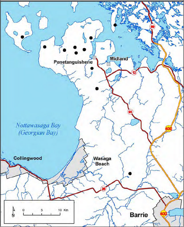
Enlarge figure 1 distribution of Forked Three-awned Grass in Ontario
Forked Three-awned Grass is an annual species, so its growth and reproduction may be influenced by environmental conditions in any given year. Therefore, the number of plants present, the number of seeds produced, and the area plants cover may vary from year to year, making it difficult to estimate the population size. The size of Forked Three-awned Grass populations ranges from around 100 plants to populations of many hectares with plants numbering into the millions (Jones 2006). The size of the total Canadian population has not been accurately determined, and there are several unsurveyed areas that may potentially host large populations. Therefore, total numbers could be near to a billion individuals.
Using the methodology of COSEWIC (2010) the total amount of area now known to be covered by the species (the Area of Occupancy or IAO) in Ontario is over 23 km2. The IAO for the total Canadian population exceeds 30 km2.
The current distribution of Forked Three-awned Grass may be related to open, sandy conditions present at the end of the last ice age (COSEWIC 2002). Seven populations were discovered by superimposing relict shoreline bluffs from glacial Lake Algonquin as mapped by Chapman and Putnam (1984) onto satellite imagery and then surveying rough, open fields, which would be suitable habitat, along the bluffs. As well, 12 additional areas of suitable habitat that could support potential populations were located with the same technique but were not surveyed (Jones 2006). The location of these populations seems to suggest that Forked Three-awned Grass is a relic from postglacial times.
It is also possible that the ancestral movements of Native peoples are partly responsible for the current distribution of Forked Three-awned Grass (Jones 2008), and thus the distribution of the species may have some cultural or historic significance. The species is currently present at several locations that were Wendat (Huron) villages in the mid-1600s according to the diaries of the Jesuit priest Jean de Brébeuf (Talbot 1949). It is also present on Beausoleil Island at the site of the village used by a group of Anishnaabe people from 1842 to 1856. In addition, the species is found on Christian Island, where this group lived after 1856. The site at Cazaville, Quebec (opposite Cornwall, Ontario), was an important stopping place for the Wendat and other people along the canoe route between Huronia and the city of Quebec (Talbot 1949).
It is not known conclusively why Forked Three-awned Grass correlates with these ancestral locations, but given the sandy habitat and the propensity of sand to find its way into human clothing, gear, etc., it can be speculated that propagules of the species may have been incidentally transported with sand by human beings. In later years, it is known that the Anishnaabe cultivated potatoes, which are usually bagged with dirt and sand on them, so transport of potatoes may have been another mechanism for movement of the species. Furthermore, Native burning practices may also have created suitable bare ground. In any case, the distribution of Forked Three-awned Grass probably results from several factors and in Ontario does not closely match that of widespread Eurasian weed species.
Trends in population size, distribution, and abundance are not known because most populations have only been known since 2001 or 2006 and most have had only one observation. Furthermore, determining the true size of a population of an annual species, which may exist more as a seed bank than as an active life stage, can be difficult, and tracking changes in habitat characteristics may provide a better indication of the status of annual species since many require some level of disturbance for exposure of the seed bank and germination (Elzinga et al. 1998). Most long-term trends affecting the abundance of Forked Three-awned Grass are the result of changes within the habitat.
3.0 Habitat needs
The ESA requires that a recovery strategy include an identification of the habitat needs of the species. Section 1.1.5 of the federal recovery strategy provides a description of the species' habitat requirements. The information provided in this section is considered to meet the requirements under the ESA. However, since the original publication of the federal recovery strategy the following new information has become available.
Forked Three-awned Grass is usually found in open, bare ground or in sparsely grassy areas dominated by Poverty Grass (Danthonia spicata), Sand Dropseed (Sporobolus cryptandrus) or Panic Grass (Panicum acuminatum var. lindheimeri). It often occurs in bare spots between tufts of other grass species. The natural disturbance regime needed by this species is discussed on page four of the federal recovery strategy.
Some types of human disturbance can be beneficial to the species. For this reason, Forked Three-awned Grass is sometimes found in trails, roadside shoulders
For example, Forked Three-awned Grass is rarely found in association with a heavy cover of Eurasian weeds or in areas of active disturbance, nor is it found in every patch of disturbed ground within dispersal distance. Several examples of recent or active disturbance were searched in close proximity to extant populations, including recently cultivated fields, a sports complex, an active sand pit, and around some new construction sites. Forked Three-awned Grass was not found in any of these places although it was present 10 to 50 m away. At these places, nearly all plants present were Eurasian species (Jones 2005, 2006).
Although most current Forked Three-awned Grass locations were once cultivated fields, today the species is not present in recently tilled, ploughed, or planted fields, and frequent breaking up of ground does not appear to benefit the species (Jones unpublished data). Agricultural use has ceased at most locations and the fields have not been turned over for years, sometimes decades (Elson pers. comm. 2005; Jones 2005, 2006;). Therefore, there may be some requirement for disturbance that exposes ground without turning it over, or there may be some length of recovery time needed before disturbed ground is suitable. This aspect requires further study.
In the absence of disturbance, habitat may become too vegetated to be suitable. It is not known how long the successional process takes, but dates from former potato fields on Christian Island and from the Native village site on Beausoleil Island suggest it can range from 25 to more than 150 years before a former cultivated field becomes completely vegetated (Jones 2005). Thus, the length of time that habitat may remain suitable may vary greatly.
The following are suggested as examples of activities that may cause the type of light disturbance that can contribute to maintenance of suitable habitat for Forked Three-awned Grass:
- light vehicle, all-terrain vehicle (ATV), and dirt bike use and other activities if they do not harm Forked Three-awned Grass plants, cause ruts, or loosen the ground surface;
- ploughing up to 75 percent of a field leaving some ground undisturbed each year and without harming Forked Three-awned Grass plants;
- parking, provided it is not on top of Forked Three-awned Grass plants;
- planes taking off and landing in close proximity to Forked Three-awned Grass;
- burning of grass including old stems of Forked Three-awned Grass; and
- normal use of a graveyard where Forked Three-awned Grass is present.
Note that high levels of these activities can become harmful to the species and may currently threaten some populations (see 4.0 Threats). Questions about threshold levels of these activities should be directed to the Ontario Ministry of Natural Resources.
4.0 Threats to survival and recovery
The ESA requires that a recovery strategy include an identification of threats to survival and recovery. Section 1.1.9 of the federal recovery strategy provides a description of threats to the species at four of the Ontario populations. The information provided in this section is considered to meet the requirements under the ESA. However, since the original publication of the federal recovery strategy the following new information has become available.
To understand the threats present at each site, it is useful to look at current land use where the populations occur (Table 2).
Table 2. Current land use in the immediate vicinity of Forked Three-awned Grass at each site (source: Jones 2005, 2006, 2008).
| Location name | Current Land Use |
|---|---|
| Anten Mills | Subdivision: driveways and yards |
| Beausoleil Island | None; national park ownership; area seldom visited by the public |
| Cedar Point Road | Agricultural field |
| Champlain Road | Motocross site; ball field |
| Christian Island | Graveyard; ATV trails; conifer plantations; ice rink parking; ball field and pow wow grounds and parking |
| Golf Link Road | Land is for sale as a development lot; roadside shoulders; |
| Huronia Airport | Grassy areas between runways |
| La Fontaine Road | Parking area beside ball field |
| Macavalley Road | Roadside shoulders; outdoor storage area; inactive field |
| Macey Lake-Methodist Point Road | Roadside shoulders, ATV trails, driveways, old sand pit, conifer plantation |
| Thunder Beach Road | Unknown after ownership change; formerly a driving range |
A threats profile for each population is given in Table 3. The presence and severity of threats in the federal recovery strategy was mostly based on COSEWIC (2002). Since the federal recovery strategy was published, the presence or severity of some threats has changed, as land use gradually shifts from agricultural to rural residential. The threats presented here are based on more recent information (Jones 2006 and personal observations 2007-2009; Promaine and Sutherland 2010; Tully pers. comm. 2010).
Table 3. Severity of current threats affecting Forked Three-awned Grass populations. "U" indicates severity of threat is unknown; a dash indicates the threat is not currently present.
| Anten Mills | Beausoleil Island | Cedar Point Road | Champlain Road | Christian Island | Golf Link Road | Huronia Airport | La Fontaine Road | Macavalley Road | Macey Lake/ Methodist Pt. Rd | Thunder Beach Road | |
|---|---|---|---|---|---|---|---|---|---|---|---|
| Succession & absence of ecological processes | High | Low | -- | Medium | High | Medium | -- | Low | U | Medium | -- |
| Development | High | -- | U | -- | Medium | High | -- | U | U | Low | Medium |
| Invasive species | U | Low | -- | Medium | High | High | Low | High | High | Medium | Medium |
| Road maintenance | U | -- | -- | -- | Low | Medium | U | Medium | High | Medium | -- |
| Agricultural practices | -- | -- | High | -- | -- | -- | -- | -- | -- | U | U |
| Trampling & ATV use | U | -- | -- | High | Medium | -- | -- | High | U | U | Low |
| Mowing | Low | -- | -- | U | -- | U | High | High | -- | -- | Medium |
| Garbage dumping | U | -- | -- | Low | Low | -- | -- | -- | U | Low | U |
Sources: Jones 2005, 2006, 2007, 2008, Promaine and Sutherland 2010, Tully pers. comm. 2010.
Limited habitat was listed as the primary threat in the federal recovery strategy. Limited habitat results from two factors: succession and development.
Successional changes and absence of ecological processes
Succession is the most widespread problem. A lack of natural disturbance, especially fire, allows vegetation to fill in open ground. Although this is a slow process, many sites are now at the stage where habitat is becoming unsuitable. Successional changes are visible at nearly all sites except Cedar Point Road.
Development
Development is a serious threat because it wipes out populations and covers up suitable habitat with lawns and pavement. This is an immediate threat at Golf Link Road where the land is for sale and marketed for development, at Christian Island where housing for community members is an important need, and potentially at other sites in this part of Simcoe County as this is a popular area for the construction of retirement and second homes.
Invasive species
The invasive species listed on page seven of the recovery strategy are a threat at many sites because they fill in spaces between grass tufts and cover the bare ground required by Forked Three-awned Grass. In addition, Scotch Pine (Scot’s Pine or Pinus sylvestris) has spread into many inactive agricultural fields (affects sites listed in the federal recovery strategy as well as new sites) causing shading and covering the ground with needles.
Road maintenance
The effects of roadside maintenance may be helpful or harmful . On the one hand, road maintenance creates the bare ground required by Forked Three- awned Grass. On the other hand, the plants may be wiped out at any time by machinery. Road maintenance is a threat where plants of Forked Three-awned Grass occur on roadside shoulders (Jones 2006).
Agricultural practices
Agricultural practices likewise may be both beneficial by keeping ground open and detrimental by wiping out plants and encouraging weeds. Forked Three- awned Grass is generally not found in recently cultivated ground but rather in the hard-packed bare ground resulting from previous cultivation. Cultivation for agricultural purposes is a current threat at Cedar Point Road where much of the population was wiped out in 2007 (Jones pers. obs. 2007).
Trampling and atv use
Although in some situations light ATV use and vehicle traffic or parking may keep habitat open and suitable, heavy use can have significant negative impacts on populations. ATV or vehicle use that causes ruts in the ground or loosening of the soil can cause habitat to become unsuitable for Forked Three-awned Grass.
Mowing
Mowing is a threat at some sites where the species occurs near other grasses that grow tall, for example at the Huronia Airport (Jones 2006). Mowing of Forked Three-awned Grass, a late-blooming annual species, can delay flowering until too late in the season, remove reproductive parts from the plants, or completely prevent successful reproduction.
Dumping of garbage
Clandestine dumping of garbage is often a problem in areas that are perceived as waste ground. Garbage covers ground needed by the species and interferes with movement of seeds during dispersal.
Sand extraction; planting of conifers
Sand extraction and planting of conifers are mentioned in the federal recovery strategy as threats, but these are not observed as current problems in Ontario at this time. There remains some continued potential that they could become threats in the future if there is a change of ownership and new landowners implement these activities on their lands.
5.0 Recovery actions completed or underway
Recovery strategies prepared under the ESA may include an identification of recovery actions completed or underway. Appendix 1 of the federal recovery strategy provides a description of actions already completed or underway. The information provided in the appendix is considered to meet the requirements under the ESA. However, since the original publication of the federal recovery strategy the following approaches have been completed or are underway.
- Community information meeting about Forked Three-awned Grass and species at risk were held on Christian Island (2006)
- Outdoor education sessions about Forked Three-awned Grass and species at risk were done with Christian Island school (2006)
- Seven additional populations and 12 potential ones were discovered by searching relict shorelines (2006)
- Informative signage was posted at Christian Island Community Centre (2008)
- Monitoring program was designed and implemented for Beausoleil and Christian Islands (2008)
- Study of historic land use on Beausoleil and Christian Islands to research ancestral connections with Native people was completed (2008)
- Preliminary mapping of critical habitat (under SARA) completed on Beausoleil Island as part of an federal action plan, and wilderness was zoning applied (2009)
6.0 Protection and recovery objectives
The ESA requires that a recovery strategy include an identification of protection and recovery objectives. Section 2.3 of the federal recovery strategy provides recovery objectives. The information provided in this section is considered to meet the requirements under the ESA. However, since the original publication of the federal recovery strategy the following new information has become available and the protection and recovery objectives have been revised accordingly.
Recent information shows that Forked Three-awned Grass is more abundant and has a somewhat greater distribution than previously thought. Therefore, federal recovery objective I has been updated to:
- Ensure viable populations of Forked Three-awned Grass persist at all known sites where the species is thought to be of natural origin (which could include ancient introductions by Aboriginal people), with population sizes equal to or greater than the current levels.
7.0 Approaches to recovery
The ESA requires that a recovery strategy include an identification of approaches to recovery. Section 2.4 and 2.6.2 of the federal recovery strategy provides a description of approaches to meet recovery objectives and activities to meet objectives. The information provided in these sections is considered to meet the requirements under the ESA. However, since the original publication of the federal recovery strategy new information has become available and the approaches to recovery have been revised accordingly.
The approaches in the federal recovery strategy were specific to each population. As there are now more populations known, the approaches laid out here are broader in application, based on jurisdiction (ownership) and on the type of activity needed. Six approaches are recommended:
Work with local governments
Working cooperatively with local government jurisdictions will be very important for recovery. Recommended approaches may include: ensuring jurisdictions are aware of all Forked Three-awned Grass locations so that the species can be protected during development applications and other land use planning; discussing ways to mitigate threats during regular activities such as road work and park and airport maintenance; and assisting with preparation of management planning for lands in their jurisdiction.
Work with Beausoleil First Nation
The federal recovery strategy recommended several approaches for working with Beausoleil First Nation to maintain and recover the Christian Island population. The following additional approaches for this population are recommended:
- Provide assistance to the Beausoleil First Nation with preparation of protective management planning for band lands containing the species,
- Provide information on Forked Three-awned Grass to the cottage association and to people using habitat for recreation (e.g., ATV users)
- Assist with the on-going monitoring of the species.
Work with private landowners
Working with private landowners should also be a key approach to recovery for the six populations that are wholly or partly on private land (Table 1). Outreach to owners to help them with stewardship is vital. Forked Three-awned Grass requires some disturbance, so a key theme for outreach should be helping landowners achieve a balance of habitat usage and protection for the grass.
Acquisition or protection of sites
Georgian Bay Islands National Park is currently the only protected area that contains Forked Three-awned Grass. Acquisition or protection by other means should be considered for additional sites if it becomes an option (for example, if a property comes up for sale or a willing landowner comes forward).
Use research to solve important knowledge gaps
Research should also be an approach, especially on key knowledge gaps that may directly affect recovery. Work has been done on some of the gaps listed in Section 1.1.10 of the federal recovery strategy (e.g. Jones 2006, 2008), but important gaps remain. For example, these questions are key issues for recovery:
- How long are Forked Three-awned Grass seeds viable in the soil and what is the role of the seed bank? Some annuals have very long seed viability and exist primarily as seed banks with only a portion of the individuals present at any one time as plants (Elzinga et al. 1998). This information would show whether (and for how long) the species is able to restore itself if ground is opened in old fields or if conifers are removed from plantations. It would also show whether former habitats should continue to be protected and whether artificial opening of ground can be a useful recovery technique.
- How can fire or other techniques be used to maintain habitat? A better understanding is needed both of natural ecological processes that maintain habitat as well as methods and protocols (such as controlled burning or mechanically scraping open ground) that can be used in the absence of these natural processes. This information could be used to guide habitat recovery and management.
- What are the natural population dynamics of Forked Three-awned Grass? This information is needed in order to know whether populations are stable and following natural cycles of increase and decrease, or whether there are declines due to threats that may warrant more urgent recovery actions.
Direct actions for protection
To protect Forked Three-awned Grass, some direct approaches are recommended. It is recommended that fertilizing, spraying of herbicide, bringing in of fill dirt and gravel, seeding of lawn species, planting of trees, and dumping of garbage should not occur in its habitat. In addition, working with municipal planners is an approach since new construction may need to be restricted at some locations if it will reduce the habitat that is available to the species. Live plants of Forked Three-awned Grass are protected under the Ontario ESA. It is recommended that mowing in the habitat of the species be done only before June 15 (before germination and before live plants are present) or after October 15 (after plants have died) to ensure individuals are protected. Live plants of Forked Three-awned Grass are also protected on roadside shoulders, although roadside shoulders are not a natural habitat. Therefore, it is recommended that grading of roadside shoulders in the vicinity of Forked Three-awned Grass be done before June 15 or after October 1.
8.0 Area for consideration in developing a habitat regulation
Under the ESA, a recovery strategy must include a recommendation to the Minister of Natural Resources on the area that should be considered in developing a habitat regulation. A habitat regulation is a legal instrument that prescribes an area that will be protected as the habitat of the species. The recommendation provided below by the author will be one of many sources considered by the Minister when developing the habitat regulation for this species.
To establish the area to be prescribed as habitat for the species, several factors will need to be taken into consideration. First, nearly all populations of Forked Three-awned Grass occur in areas that were formerly cultivated fields that have recovered to semi-natural barrens or grassland vegetation. However, the vegetation community of the old field-barrens (excluding Beausoleil Island) does not well match the species composition and disturbance regime of a natural sand barrens (an exceedingly rare vegetation type in Ontario, ranked S1
Second, not all disturbed ground is suitable for Forked Three-awned Grass. There are distinct types of recent disturbance or stages of recovery from older disturbance that make habitat suitable for the species. Thus, not all inactive agricultural fields, vacant lots or roadside verges are suitable habitat. For the time being, in the absence of data on the length of time seeds remain viable in the soil, occupancy by active life stages of the species is probably the best indication of the area that should be prescribed as habitat.
Finally, Forked Three-awned Grass occurs in some places on roadside shoulders, which are anthropogenic habitats with very active use and a higher level of disturbance than is thought to be beneficial (see 3.0 Habitat Needs, above). Shoulders are considered temporary habitat where the species is not likely to persist for the long term. For example, a population present on a shoulder in the Rainy River District in 2001 has not reoccurred in subsequent years. Given this, it is suggested that roadside shoulders not be prescribed as habitat in a regulation for this species. It is recommended instead that sufficient grassland and barrens habitat be prescribed in the regulation to ensure the recovery and sustainability of the species. Individual Forked Three-awned Grass plants are protected under the ESA and may not be harmed, whether they are within or outside of the area prescribed in the regulation.
Therefore, it is recommended that the area prescribed as Forked Three-awned Grass habitat in the regulation include:
- areas where Forked Three-awned Grass occurs with semi-natural grassy vegetation: the area occupied by the species, plus the adjacent continuously open area surrounding the Forked Three-awned Grass plants if this area is occupied by the associates Poverty Grass, Sand Dropseed, or Panic Grass, or if open, bare, sandy ground is visible, even if these are small patches of a few centimetres between grass tufts or shrubs (open area means there is no canopy of trees, and at least some grassy or bare patches are present between shrubs.); and
- areas where Forked Three-awned Grass occurs in bare ground or interspersed with non-native species (in any ratio or combination): the area occupied by the species, plus the rest of the continuously open area (see above) surrounding the Forked Three-awned Grass plants where there is open, bare, sandy ground with the substrate visible, even if these are small patches of a few centimetres between non-native plants or grass tufts.
Note that populations may occur in a combination of the two situations above.
As discussed on page 15 of the federal recovery strategy, it is necessary to include the adjacent area in 1) and 2) above as the species may be present in the seed bank in this area, and to provide habitat for new dispersal. As well, the sandy substrate may blow or shift, so the adjacent area may accommodate the natural movement of colonies over time.
For the sake of simplicity, it is suggested that in most cases the area to be considered will include the entire open field. However, in some cases the boundaries of the habitat may need to be determined or fine-tuned on the ground, for example, where the habitat is becoming overgrown or where the species exists only along a trail.
Disturbance is an integral part of suitable habitat for Forked Three-awned Grass, so it is suggested that habitat where obvious human disturbance is occurring should not be excluded from the area prescribed as habitat in a regulation provided the species is present and the area is adjacent to a current population as in 1) and 2) above.
References
Chapman, L.J. and D.F. Putnam. 1984. The Physiography of Southern Ontario (3rd ed.). Ontario Geological Survey, Special Volume 2. Ontario Ministry of Natural Resources. 270 pp.
COSEWIC 2010. Definitions and abbreviations for status reports. Available on line at http://www.cosewic.gc.ca/eng/sct2/sct2_6_e.cfm Accessed September 15, 2010.
COSEWIC. 2002. COSEWIC Assessment and status report on the Forked Three-awned Grass Aristida basiramea in Canada. Committee on the Status of Endangered Wildlife in Canada, Ottawa 29 pp. http://www.cosewic.gc.ca
Elson, Elizabeth, personal communication. 2005. Forestry technician and band councilor, Beausoleil First Nation, Christian Island, Ontario.
Elzinga, C.L., D.W. Salzer, and J.W. Willoughby. 1998. Monitoring Plant Populations. Bureau of Land Management Technical Reference 1730-1. BLM, Denver, Colorado, USA. 496 pp.
Featherstone, David, personal communication 2010. Manager, Watershed Monitoring Program, Nottawasaga Valley Conservation Authority, Utopia, Ontario
Jones, J.A. 2005. Report from field work on Forked Three-awned Grass (Aristida basiramea). Unpublished report for Parks Canada, Species at Risk Section, Ottawa, Ontario.
Jones, J.A. 2006. Search for suitable habitat and new populations of Forked Three-awned Grass (Aristida basiramea). Unpublished report to Parks Canada, Species at Risk Section, Ottawa, Ontario.
Jones, J.A. 2007. Recovery strategy for Forked Three-awned Grass (Aristida basiramea Engelm. Ex Vasey) in Canada. In Species at Risk Act Recovery Strategy Series. Ottawa: Parks Canada. 25 pp.
Jones, J.A. 2008. History of land use in Aristida habitat: Beausoleil Island and Christian Island. Unpublished report for Georgian Bay Islands National Park (Parks Canada), Midland, Ontario. 7 pp.
Natural Heritage Information Centre. 2010. On line databases, Ontario Ministry of Natural Resources, Peterborough. /page/natural-heritage-information-centre Accessed March 20, 2010.
Oldham, Michael J. Personal communication 2008. Botanist, herpetologist, Natural Heritage Information Centre, Ontario Ministry of Natural Resources, Peterborough.
Pielou, E.C. 1991. After the Ice Age: The Return of Life to Glaciated North America. University of Chicago Press, Chicago, Illinois. 366 pp.
Promaine, A. and R. Sutherland. 2010. Forked Three Awned Grass (Aristida basiramea) monitoring within Georgian Bay Islands National Park, 2009. Unpublished report to Parks Canada, Species at Risk Section, Ottawa.
Talbot, F.X. 1949. Saint Among the Hurons: The Life of Jean de Brebeuf. Harper & Brothers, New York. 351 pp.
Tully, Tim, personal communication 2010. Natural Heritage Specialist, Awenda Provincial Park.
Species at Risk Act Recovery Strategy Series
Forked Three-awned grass
February 2007
About the Species at Risk Act recovery strategy series
What is the Species at Risk Act (SARA)?
SARA is the Act developed by the federal government as a key contribution to the common national effort to protect and conserve species at risk in Canada. SARA came into force in 2003 and one of its purposes is "to provide for the recovery of wildlife species that are extirpated, endangered or threatened as a result of human activity."
What is recovery?
In the context of species at risk conservation, recovery is the process by which the decline of an endangered, threatened or extirpated species is arrested or reversed, and threats are removed or reduced to improve the likelihood of the species' persistence in the wild. A species will be considered recovered when its long-term persistence in the wild has been secured.
What is a recovery strategy?
A recovery strategy is a planning document that identifies what needs to be done to arrest or reverse the decline of a species. It sets goals and objectives and identifies the main areas of activities to be undertaken. Detailed planning is done at the action plan stage.
Recovery strategy development is a commitment of all provinces and territories and of three federal agencies -- Environment Canada, Parks Canada Agency and Fisheries and Oceans Canada -- under the Accord for the Protection of Species at Risk. Sections 37–46 of SARA (Species at Risk Act) spell out both the required content and the process for developing recovery strategies published in this series.
Depending on the status of the species and when it was assessed, a recovery strategy has to be developed within one to two years after the species is added to the List of Wildlife Species at Risk. Three to four years is allowed for those species that were automatically listed when SARA came into force.
What’s next?
In most cases, one or more action plans will be developed to define and guide implementation of the recovery strategy. Nevertheless, directions set in the recovery strategy are sufficient to begin involving communities, land users, and conservationists in recovery implementation. Cost-effective measures to prevent the reduction or loss of the species should not be postponed for lack of full scientific certainty.
The series
This series presents the recovery strategies prepared or adopted by the federal government under SARA. New documents will be added regularly as species get listed and as strategies are updated.
To learn more
To learn more about the Species at Risk Act and recovery initiatives, please consult the SARA Public Registry and the website of the Recovery Secretariat.
Recovery Strategy for Forked Three-awned Grass (Aristida basiramea) in Canada
February 2007
Recommended citation:
Jones, J.A., 2007. Recovery strategy for Forked Three-awned Grass (Aristida basiramea Engelm. ex Vasey) in Canada. In Species at Risk Act Recovery Strategy Series. Ottawa: Parks Canada. 25 pp.
Additional copies:
You can download additional copies from the SARA Public Registry.
Cover illustration:
From: The Illustrated Flora of Illinois: Grasses, Panicum to Danthonia – 2nd Edition by Dr. Robert H. Mohlenbrock, with permission from Southern Illinois University Press.
Également disponible en français sous le titre « Programme de rétablissement de l'aristide à rameaux basilaires (Aristida basiramea Engelm. ex Vasey) »
© Her Majesty the Queen in Right of Canada, represented by the Minister of the Environment, 2007. All rights reserved.
Content (excluding the illustrations) may be used without permission, with appropriate credit to the source.
Responsible authorities
Development of the recovery strategy for Forked Three-awned Grass was led by the Parks Canada Agency on behalf of the competent minister (the Minister of the Environment). Forked Three-awned Grass occurs in Québec and Ontario, and the following governments and Aboriginal group cooperated in the production of this recovery strategy:
- Beausoleil First Nation
- Province of Québec
- Province of Ontario
- Canadian Wildlife Service (Ontario and Québec)
Authors
The Strategy was prepared by Judith Jones, Winter Spider Eco-Consulting.
Acknowledgments
We would like to acknowledge the significant effort of the current and past members of the Forked Three-awned grass Recovery Team:
- Patrick Nantel, Parks Canada Agency (Chair)
- Gary Allen, Parks Canada Agency (Ontario)
- Line Couillard, Ministère du Développement durable, de l'Environnement et des Parcs, Québec (past member)
- Guy Jolicoeur, Ministère du Développement durable, de l'Environnement et des Parcs, Québec
- David Featherstone, Nottawasaga Valley Conservation Authority
- Melvin King, Beausoleil First Nation (past member)
- Jennifer Copegog, Beausoleil First Nation
- Andrew Promaine, Georgian Bay Islands National Park
- Ken Tuininga, Canadian Wildlife Service
- Tim Tully, Awenda Provincial Park, Ontario Parks
We would also like to thank the many individuals who provided information for and feedback on this document, especially Gary Allen, Wasyl Bakowsky, David Featherstone, Melvin King, Mike Penskar, Mike Oldham, and Beausoleil First Nation Chief Valerie Monague and her Council. Ms. Mona Ross, of Southern Illinois University Press, kindly provided permission to use the line drawing which occurs on the title page, from Dr. Robert Mohlenbrock’s Flora of Illinois, in perpetuity.
Declaration
Under the Accord for the Protection of Species at Risk (1996), the federal, provincial, and territorial governments agreed to work together on legislation, programs, and policies to protect wildlife species at risk throughout Canada. The Species at Risk Act (S.C. 2002, c.29) (SARA) requires that federal competent ministers prepare recovery strategies for listed Extirpated, Endangered and Threatened species.
The Minister of the Environment presents this document as the recovery strategy for Forked Three-awned grass as required under SARA. It has been prepared in cooperation with the jurisdictions responsible for the species, as described in the Preface. The Minister invites other jurisdictions and organizations that may be involved in recovering the species to use this recovery strategy as advice to guide their actions.
The goals, objectives and recovery approaches identified in the strategy are based on the best existing knowledge and are subject to modifications resulting from new findings and revised objectives.
This recovery strategy will be the basis for one or more action plans that will provide further details regarding measures to be taken to support protection and recovery of the species. Success in the recovery of this species depends on the commitment and cooperation of many different constituencies that will be involved in implementing the actions identified in this strategy. In the spirit of the Accord for the Protection of Species at Risk, all Canadians are invited to join in supporting and implementing this strategy for the benefit of the species and of Canadian society as a whole. The Minister of the Environment will report on progress within five years.
Preface
The Species at Risk Act (SARA, Section 37) requires the competent minister to prepare recovery strategies for listed extirpated, endangered or threatened species. The Forked Three-awned Grass was listed as Endangered under SARA in January 2005. The Parks Canada Agency led the development of this Recovery Strategy. All other responsible jurisdictions reviewed and acknowledged receipt of the strategy (Beausoleil First Nation, the Canadian Wildlife Service, the Province of Québec, and the Province of Ontario). The proposed strategy meets SARA requirements in terms of content and process (Sections 39-41). It was developed in cooperation and consultation with the Canadian Wildlife Service (Ontario and Québec) and the Beausoleil First Nation.
Strategic environmental assessment statement
A strategic environmental assessment (SEA) is conducted on all SARA recovery planning documents, in accordance with the Cabinet Directive on the Environmental Assessment of Policy, Plan and Program Proposals. The purpose of a SEA is to incorporate environmental considerations into the development of public policies, plans, and program proposals to support environmentally-sound decision making.
Recovery planning is intended to benefit species at risk and biodiversity in general. However, it is recognized that strategies may also inadvertently lead to environmental effects beyond the intended benefits.
Overall, this strategy will have positive effects not only on the target species but also on the environment as a whole. Establishing protected areas where Aristida basiramea is found will help protect most other species found on those lands. Increased education and awareness of landowners may also have an overall positive effect on the environment by increasing stewardship activities.
While this recovery strategy will clearly benefit the environment, several potentially adverse effects were also considered. The adverse environmental effects include:
- Damage and/or destruction of non-target plant species, during research and monitoring as a result of trampling. For example, the white-tinge sedge (Carex albicans var. albicans (= C. artitecta)), a species listed as S2 in Ontario (6 to 20 occurrences) and noted in 2003 in close proximity to the Forked three-awned grass at GBI) (Parks Canada Biotics, 2005);
- Damage and/or destruction of nesting sites, residences, or habitat of animal species including species at risk, during research and monitoring as a result of trampling. For example, spotted turtle (Clemmys guttata) (Endangered), although not recorded since 1974 in GBI NP, could nest in the habitat where A. basiramea occurs);
- Disturbance of animal and bird species during monitoring by presence of researchers in area; and
- Damage and/or destruction of non-target species and habitat during prescribed burning, especially invertebrates.
The potential adverse environmental effects on non-target species during research and monitoring can be mitigated by determining exactly what other species are in the area and ensuring that any research and monitoring is done at times or in locations that will avoid or minimize disturbance to other sensitive species or their habitats. Annual burning could have adverse effects if conducted in areas where there are species sensitive to fire. If the habitat of the Christian Island population is to continue to be burned annually, then a determination of the other species occurring in this area should be completed to make certain that other non-target species are not adversely affected. Follow-up monitoring is recommended for any burning that is done to enhance forked three-awned grass habitat.
The majority of the known populations of Forked Three-awned Grass in Canada occur on Beausoleil First Nation lands. Concern has been expressed by Beausoleil First Nation regarding the amount of responsibility that will be placed on them to protect the species. The adverse socio-economic effects and appropriate level of responsibility will be examined in more detail at the action plan stage.
Executive summary
The Endangered Forked Three-awned Grass, also called Ice Age Grass, (Aristida basiramea) is an annual grass found in dry, open, acidic sand barrens, but the species will exploit weedy habitats associated with these sites, such as roadside ditches and old fields. It is highly intolerant of shading and competition from other plants.
Less than 1% of the global population of A. basiramea occurs in Canada, with the core range in the Midwestern United States. In Canada, A. basiramea is currently known from five naturally occurring sites: Cazaville in southwestern Québec; and Christian Island, Beausoleil Island, Anten Mills, and Macey Lake, all in the southern Georgian Bay area of Ontario. Total number of plants in Canada is estimated to be >150 000; most of the population occurs at only four sites and total occupancy (all sites) is about 20 km2 . The largest population is that at Christian Island, where it was documented in 2005 as occurring in 15 sub-populations totaling over 100 000 individuals.
Habitat availability and associated ecological processes are the most important limiting factors for the species in Canada. Threats include limited habitat, sand extraction, succession and absence of ecological processes, development, planting of conifers, invasive species, all-terrain vehicles (ATV) use, agricultural practices, and garbage dumping. Given the current state of our knowledge, critical habitat for the species cannot be defined precisely enough at this time without further studies. A summary of available knowledge is presented including the types of habitat where the species has been found so far. Unoccupied patches of open sandy soil in the vicinity of occupied ones are considered important habitat. The recovery goal is to maintain self-sustaining populations of Aristida basiramea at all the sites where the species is of native origin in Canada, as part of Canada’s natural heritage, and as a fulfillment of the government of Canada’s commitments to protect biodiversity. The recommended approach is to protect habitats, on a site-by-site basis, as follows:
- Georgian Bay Islands National Park, Beausoleil Island: park management and zoning.
- Macey Lake: cooperative work with private landowners and the municipality on stewardship.
- Anten Mills: cooperative stewardship and exploration of other tools.
- Christian Island: 1) cooperative work with Beausoleil First Nation on stewardship and 2) outreach and dialogue with owners of Certificate of Possession lands.
- Cazaville: 1) consideration to make a designation such as Habitat Floristique or natural reserve on private lands under the Québec’s legislation ; 2) education and outreach to private landowners on stewardship actions.
Knowledge Gaps are:
- Locations of other potential populations in the Southern Georgian Bay region.
- Population dynamics, trends and viability, the importance of the soil seed bank.
- Factors which maintain critical habitat in sand barrens: the role of fire and other processes which clear ground. This study is needed to define critical habitat.
- Traditional Native knowledge about the history of Ice Age Grass.
Action plans will be prepared within four responsibility areas: Province of Ontario, Province of Québec, Parks Canada Agency, and Beausoleil First Nation. Many starting points for the development of action plans are listed in the strategy. Actions already underway or completed are listed in Appendix 1.
1. Species information
Common Name (population): Forked three-awned grass
Scientific Name:Aristida basiramea
Assessments Summary:
COSEWIC Status: Endangered
Reason for designation: Few disjunct and fragmented populations found in very small habitats within populated areas subject to further habitat disruption and loss through activities such as sand extraction, recreational use and urban development.
Canadian Occurrence: Ontario and Quebec
COSEWIC Status History: Designated Endangered in November 2002. Assessment based on a new status report.
1.1 Background
1.1.1 Species information
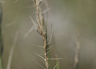
Forked Three-awned Grass, or Ice Age Grass (Aristida basiramea) is an annual grass that grows in tufts. It has extremely narrow leaves (1 mm wide) which often have the margins curled inward, and wiry stems which reach 30-60 cm in height. Plants branch at the base and only sparingly above. The inflorescence is 10-20 cm long, borne at the end of erect stems. The glumes (two tiny bracts around at the base of the spikelets) each have a single vein and are unequal in length with the second being the longer. One of the bracts (i.e. lemma) subtending individual fruits has three awns: two relatively short lateral ones which are erect, and a longer middle awn which is coiled at the base and which sticks out at a divergent angle (Gleason and Cronquist, 1991). The species is late-developing, with flowering and fruit-set occurring from late August through October (COSEWIC, 2002).
1.1.2 Global distribution and Canadian range
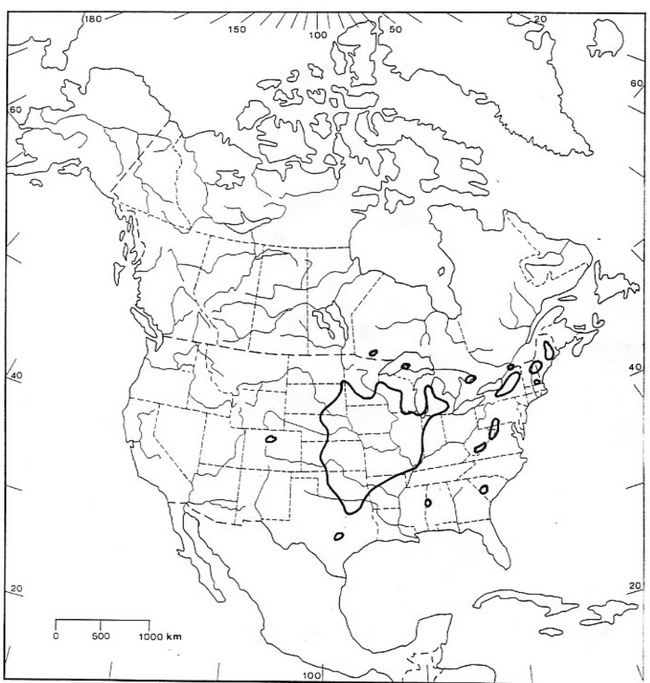
The disjunct distribution of Canadian populations of A. basiramea is believed to be a relict of past climates. There is also the suggestion that the distribution of the species may be associated with the migration of Aboriginal peoples. The core range of the species is in the Midwestern United States, and less than 1% of the global population of A. basiramea occurs in Canada (Figure 1). The species has never been known to be more common in Canada. Only five sites have been discovered in Southern Ontario and Southern Québec since 1975.
A. basiramea is currently known from five naturally occurring sites: one in southwestern Québec and four others in Ontario in the southern Georgian Bay area (Table 1). A population discovered in 2001 in the Rainy River District of Ontario (COSEWIC 2002), believed to be introduced in gravel brought in to repave the road, did not persist (Wasyl Bakowsky, pers. comm. 2005, 2006), and no typical natural habitat is present in the environs (Michael Oldham, pers. comm., 2005).
The species currently has the following conservation rankings
- G5 globally (NatureServe 2005)
- N4 in the United States (NatureServe 2005)
- N1 in Canada (NatureServe 2005)
- S1 in Ontario (Oldham 1999)
- S1 Québec (NatureServe 2005; Barbeau and Brisson, 2004)
It has been designated as "Endangered (not regulated)" on the Species at Risk in Ontario list, and is recommended for designation as "menacée" (threatened), the highest level of concern under Québec provincial legislation.
Figure 1. Global range of A. basiramea (From COSEWIC, 2002)
1.1.3 Population size and trend
As of fall 2005, the total number of plants in Canada is estimated to be in excess of 100 000, likely between 150 000 and 300 000. Most of the population occurs at only four sites and total occupancy (all sites) is about 20 km2 (Table 1, COSEWIC, 2002, Jones 2005). The largest population is that at Christian Island, where it was documented in 2005 as occurring in 15 sub-populations totaling over 100 000 individuals (Jones 2005). Because the majority of sites have only been known since 2001, it is not yet possible to determine if change is occurring in population size or geographical distribution. Also, because the species is an annual, the size of its populations have large yearly fluctuations.
Table 1. Characteristics of A. basiramea occurrences in Canada
| Site name (Province) | Land ownership | Number of subpopulations and area of occupancy1 | Total number of plants (2005)2 |
|---|---|---|---|
| Anten Mills (Ontario) | Privately owned by 2 or 3 owners, but one subpopulation under a conservation easement since 2004 | 1 population in 4 patches in 2002; not known how many still remain | < 100 |
| Beausoleil Island (Ontario) | Georgian Bay Islands National Park | 1 population; area of occupancy 100 x 50 m. | > 1 500 |
| Macey Lake (Ontario) | Privately owned by more than one owner; part is designated a provincial area of natural and scientific interest (ANSI) | >1 subpopulation; total area unknown | >10 000 |
| Cazaville (Québec) | Privately owned by many owners; two lots in municipal control | 6 subpopulations within 15 km2 | > 10 000 |
| Christian Island (Ontario) | Beausoleil First Nation: community-owned land, as well as Certificate of Possession lands | At least 15 subpopulations within about 4 km2 | > 100 000 |
Footnotes
1A subpopulation at Cazaville is equivalent to an element occurrence (EO) (See Barbeau and Brisson (2004) for a definition), while those at other sites aggregate to form one EO at each.
2Numbers in COSEWIC (2002) were updated in 2005.
1.1.4 Biologically limiting factors
A. basiramea is a very late-maturing annual, flowering in late August-September and setting fruit in September-October. It has been suggested that reproduction is naturally limited by the arrival of the end of the growing season, and that this climatic factor may also determine how far north the species is able to grow (COSEWIC, 2002). It has been speculated that climate is a limiting factor for A. basiramea in Québec since there is some suitable habitat north of the existing population of Cazaville (Line Couillard, pers. comm. 2005). Interference with the ecological processes required by the species to maintain populations or to colonize new areas may also be limiting factors. Availability of suitable habitat is considered the number one limiting factor for this species in Canada. See next section as well as section1.1.9 Threats.
1.1.5 Habitat requirements
A. basiramea requires areas of sandy, open ground. It appears to be highly intolerant of shading and competition from other plants (COSEWIC, 2002). Barbeau and Brisson (2004) report that the species prefers areas where there is an average of 33% bare ground, and little other woody or herbaceous vegetation in the immediate surroundings. The species is found in open sand barrens, sandy forest openings and sandy fallow fields, as well as on the sandy edges of roads and trails. The pH of the substrate is presumably acidic.
All five of the Canadian sites with A. basiramea are on sand barrens on relict post-glacial shorelines or dunes. Barbeau and Brisson (2004) infer that the Cazaville area was originally a woodland of white pine (Pinus strobus) where a fire regime kept patches of ground in an open state, up until colonization ,when the white pines were cut and the area cleared.
In Michigan the species is known from dry, open sandy ground (Voss, 1972), specifically sandy open areas in oak woodlands or oak barrens (Penskar, pers. com. 2005). In the Great Plains region it is reported from "roadsides, pastures and waste ground" (McGregor, et al., 1986). These differing reports show a presence in both natural habitats and habitats altered by human use.
Natural disturbance processes are important for this species. Ecological processes that maintain sandy habitat in an open, barren state are considered habitat requirements. Fire may be required to create and maintain open, barren ground to sustain A. basiramea at some of the sites. For example, Beausoleil First Nation has conducted annual prescribed burns for years at one of their main sub-populations, as part of the maintenance of a baseball field. This low-intensity burning has successfully maintained a high quality sand barren in which A. basiramea thrives. At Georgian Bay Islands National Park there has been a historic role of fire in the ecosystem, but that role is not clearly understood yet (Quenneville, pers. comm. 2006). Drought and wind-throw of trees may also be naturally-occurring processes which help maintain open ground. Shoreline processes such as ice scours and changing lake levels may also play the same role.
Many sites on Christian Island where A. basiramea now grows were once ploughed fields. Whether or not a similar disturbance today would be able to create suitable habitat is unknown, as other species have been introduced that may prevent A. basiramea from early colonization of newly disturbed ground.
Historically, A. basiramea's habitat may not necessarily have been maintained at any one spot by fire or other disturbances, but rather was maintained by being present within the overall landscape. Suitable habitat is an early successional vegetation type which once grew on naturally disturbed sites, colonizing when there was disturbance, gradually disappearing with the filling in of vegetation, and then reappearing somewhere else in the landscape after a new disturbance. This kind of regime has been documented for bur oak savanna on Manitoulin Island, Ontario (Jones, 2000). Since we may no longer have the natural dynamics that created suitable habitat on a landscape scale, recovery must look at maintaining the habitat that currently exists.
1.1.6 Residence description
Damaging or destroying the location of individual plants of A. basiramea will automatically damage or destroy the individuals, so there is no need for a description of residence for this species to enforce the general prohibitions of the Species at Risk Act.
1.1.7 Ecological roles
The ecological role of the species has not been studied. Allred (2001) reports that quail and small mammals eat small amounts of the seed. Presumably A. basiramea could provide late season food or cover for insects preparing to over winter. As well, it may have some role in colonization or stabilization of dry, open substrates of coarse texture.
1.1.8 Importance to people
A. basiramea occurs at two locations where people of Beausoleil First Nation have lived (Christian and Beausoleil Islands). The possibility of a cultural link should be investigated as it may shed light on the origin or maintenance of key populations of the species in Canada. In addition, Aristida basiramea occurs at several sites of cultural significance to Beausoleil First Nation.
A. basiramea is not known to have any economic significance.
1.1.9 Threats
Habitat availability is considered the most important limiting factor for the species in Ontario. Nearly all threats to A. basiramea (Table 2) are threats to habitat, and with only five known sites, any habitat loss is extremely serious.
In addition to the threats to habitat described below, it is not known whether global climate change would affect this species. A. basiramea grows in high light and heat conditions, in dry substrate, with lots of exposure. As well, other species present in the habitat (especially Danthonia spicata) are similarly adapted. Therefore, it is difficult to speculate whether climate change would hinder or help A. basiramea until more is known about future conditions.
Table 2. Threats to A. basiramea populations and habitat, and their severity at individual sites
| Threat | Anten Mills | Beausoleil Island | Cazaville | Christian Island | Macey Lake |
|---|---|---|---|---|---|
| Limited habitat | High | High | Low | Low | High |
| Sand extraction | None | None | High | None | None |
| Succession & absence of ecological processes | High | Low | Low | Low | Medium |
| Development | High | None | None | Medium | None |
| Planting of conifers | High | None | Low | Low | None |
| Invasive species | Low | Low | Low | High | Medium |
| ATV use | Low | None | Medium | Low | Medium |
| Agricultural practices | None | None | Low | None | None |
| Garbage Dumping | High | None | High | Medium | High |
Sources: Jones 2005, Barbeau and Brisson 2004, COSEWIC, 2002; and personal observations of Recovery Team members.
Limited habitat
There is very little habitat currently available which fulfills the open, barren, sandy requirements of the species in Ontario. Sand barren vegetation communities in Ontario are critically imperiled and ranked S1 or S2 by Ontario’s Natural Heritage Information Centre (NHIC) (Bakowsky, 1996). In Québec, the Cazaville site is the only large sand opening in Southwestern Québec (Barbeau and Brisson, 2004). Further loss of suitable open sandy habitat continues to occur through fire suppression, changing shoreline processes, succession, and several other threats, explained below.
Sand extraction
Open sandy areas are often suitable places for commercial extraction of sand. Sand extraction destroys both habitat and plants, although the disturbed open ground created by the process can be suitable habitat for the species after the fact (COSEWIC, 2002). Sand extraction is currently occurring at two of six Cazaville subpopulations (Barbeau and Brisson, 2004).
Successional changes and absence of ecological processes
Plant succession and eventual formation of forest canopy causes naturally open areas to become unsuitable for the species. The habitat of A. basiramea would normally be only early successional vegetation, although open habitat can be maintained for many years by fire, drought, shoreline processes such as ice scours and changing lake levels, or other natural disturbance. In the absence of these ecological processes, habitat becomes too densely vegetated and unsuitable. Successional changes are visible at all sites.
Development
While some human disturbance has proved beneficial to the species by creating new open substrate, development damages and destroys habitat. Building and driveway construction eliminate open ground. Landscaping may cover barren patches and introduce invasive species. Human occupation of sandy areas also results in an increased need for fire suppression. Subdivision development (2003-2004) caused the loss of the majority of the Anten Mills population. Subdivision development may threaten other recovery habitat in the Simcoe County, Ontario area due to the rapid expansion of the nearby communities of Barrie and Wasaga Beach. Residential construction may threaten one subpopulation at the Macey Lake site. Results from a recent survey of the species on Christian Island (Jones 2005) indicate a moderate level of threat to the species from development or associated activities, especially where A. basiramea occurs in open spaces in and adjacent to the village.
Planting of conifers
Since the 1920s many programs have sought to stabilize soils that are highly susceptible to wind erosion and improve barren ground. Plantations of conifers, ultimately becoming closed canopy stands, have eliminated previously suitable habitat at Anten Mills and at Cazaville (occurrence #2). Efforts to plant conifers continue to be a threat at Cazaville while at Anten Mills the continuing growth and closing-in of the forest canopy is further reducing the amount of open ground (COSEWIC 2002; Barbeau and Brisson, 2004).
Invasive species
Several invasive species have been reported in the habitat of A. basiramea including:
- Glossy Buckthorn (Rhamnus frangula)
- Scot’s Pine (Pinus sylvestris)
- Spotted Knapweed (Centaurea maculosa)
- White Sweet Clover (Melilotus alba)
- Mouse-Ear Hawkweed (Hieracium pilosella)
- Sheep Sorrel (Rumex acetosella)
These species have the potential to quickly take over and vegetate the open ground that A. basiramea requires. Scot’s Pine in particular was noted to be spreading quickly at the Macey Lake and Anten Mills sites (COSEWIC, 2002). Spotted Knapweed is a dominant now on the periphery of the Macey Lake population (Gary Allen, pers. comm. 2005) and White Sweet Clover is spreading on Christian Island (Gary Allen, pers. comm. 2005). Mouse-ear hawkweed blankets the ground in open spaces between grass tufts (prime spots for A. basiramea growth), destroying the suitability of much habitat on Christian Island (Jones, 2005). Based on current knowledge, the threat of invasive species may be a key issue in habitat suitability. Studying the use of burning and other tools to mitigate the effects of invasive species on A. basiramea will be addressed in Action Plans.
All-terrain vehicle (ATV) use
Light use of ATVs may keep sandy habitats open and provide suitable habitat for the species; however, ATVs also trample plants and damage vegetation. At Cazaville, four out of six subpopulations have ATV trails through them. The increase in use and the number people riding off-trail threatens both plants and their habitats. (Barbeau and Brisson, 2004). The degree of ATV use at other sites is not known.
Agricultural practices
Most of the Cazaville site is surrounded by agricultural operations, and some of the Cazaville subpopulations are on fallow fields, testimony to agricultural use in the past. An area of formerly suitable habitat was leveled and worked up in 2003 for planting in 2004 (Barbeau and Brisson, 2004). The area of one of the main populations at Christian Island was used both for crops and pasture in the past. None of the known A. basiramea sites is currently used as pasture, however, grazing by livestock sometimes causes introduction of weeds, reductions of native species presence, and is considered a threat to other naturally open habitats (Jones and Jalava, 2005; Reschke et al. 1999). Although some protection for the Macey Lake site is given in the Tiny Township Official Plan, agricultural use is not excluded (The Planning Partnership, 2000).
Dumping of garbage
Natural barren lands often carry the misconception that they are waste land where indiscriminate usage does not matter. People do not see sand barrens as having the same beauty as a forest. This misconception can spur human-caused damage and destruction. In particular, barren grounds often become places for clandestine dumping of garbage.
1.1.10 Knowledge gaps
- Recent discoveries of the species in the vicinity of Awenda Provincial Park (Fall 2005) are sub-populations of the Macey Lake site. However, these discoveries suggest there may be other sites in the Southern Georgian Bay area of Ontario, especially on other sandy islands and small sandy patches occurring randomly in the landscape. In spite of the fact that the region has historically been relatively well botanized, the species develops late in the growing season and does not fruit until late September, a time when comparatively less botanical work happens. A survey needs to be conducted for A. basiramea, in suitable habitat, at the time when it is most easily detected.
- Little is known about the species' population dynamics, trends and viability, particularly the role of the soil seed bank. Several sites were only discovered in 2001, and most populations have not been re-surveyed since that time, so new data needs to be collected. This will be addressed by a monitoring program.
- There is a need for better understanding of ecological processes involved in maintaining habitat availability for the species. What is needed to maintain good quality habitat? Is controlled burning needed? What is the fire history and what were natural fire cycles like at these sites? Will other, more mechanical (anthropogenic) methods of clearing ground be sufficient? Monitoring the removal and reintroduction site at Christian Island will only begin to fill this knowledge gap.
- Is there traditional Native knowledge or history about this species? It could be important to know if there is a link between Native land use (historical and current) and the current distribution of A. basiramea, because it may show how the species came to be where it is, as well as whether some land use practices are beneficial to maintenance of the species.
2. Recovery
2.1 Recovery feasibility
Recovery of A. basiramea in Canada is determined to be feasible because the species meets all four necessary conditions (Environment Canada 2005), as described below.
- The presence of dense growth of A. basiramea in localized areas suggests that individuals are capable of reproducing at a rate sufficient to improve population sizes and potentially, population growth rate. Furthermore, the presence of adventive populations in the eastern United States indicates that the species is able to grow and survive even if the seeds arrive in only marginal dry, open terrain.
- The species' habitat in Canada has been described as "dry open sand barrens, on low, sand ridges or dunes, located on post-glacial shorelines" (COSEWIC 2002). The availability of that type of habitat can be limited by overgrowth of vegetation and is assumed to be maintained by recurrent fires or drought. More habitat can be made suitable by creating open ground in sandy areas adjacent to existing populations.
- Significant threats to the species such as sand extraction, changes brought by vegetation succession, permanent habitat losses (through development), conifer plantations, and invasive species (COSEWIC 2002) can be effectively avoided or mitigated through (1) the use of management and stewardship actions to protect and improve habitat; and (2) research and monitoring to support conservation and management decisions.
- Many techniques exist that can contribute to the recovery of this species. While these techniques have not yet been tested on A. basiramea, they have proven effective in conservation of other annual plant species in similar habitats (see for example Pavlik 1993).
2.2 Recovery goal
Considerations:
- The few populations of Aristida basiramea occurring in Canada form the northern limit of the species' distribution in southern Ontario and Québec. The species is widely distributed in the United States where its status is secure in most states. However, in some of the U.S 'outliers', i.e. New York and New Hampshire, it is considered as S1 or S2 (Oldham 2002).
- There is no evidence that the distribution of the species has diminished or that the number of populations has declined in Canada due to direct or indirect human activities in recent history. However, at least one population has been greatly reduced by housing development in the past few years, and is on the verge of extirpation. Also, the species occurs in Canada as naturally disjunct populations believed to be relicts of past climates, or possibly related to migration of aboriginal peoples. This makes the species of conservation, cultural, and scientific interest.
- The species has shown an ability to colonize disturbed sites.
- There is no specific knowledge about the dynamics of the species' populations, especially of the soil seed bank, so their long-term viability cannot be assessed.
The conditions stated above do not warrant actively extending its distribution range in Canada, but augmenting local populations may be needed.
The recovery goal for the species is therefore:
"To maintain self-sustaining populations of Aristida basiramea at all the sites where the species is of native origin in Canada."
Even with good potential for mitigating threats, because habitat for A. basiramea is naturally extremely rare and fragmented, the species may still meet COSEWIC criteria for endangered or threatened species in 2012 when its status will be reassessed. However, it is hoped that the species will be downlisted to "special concern," if there is evidence that recovery factors have combined to ensure the species' security. Criteria for this assessment could include recovery measures implemented with success, no significant loss in area of occupancy, and ideally, discoveries of a significant number of new occurrences. See section 2.7 Evaluation.
2.3 Recovery objectives
- A. basiramea persists in its natural habitat at the five known sites where the species is thought to be of natural origin2, with population sizes remaining viable for the next 10 years and beyond.
- Measures necessary to avoid and mitigate threats to the species and its habitat are identified and mitigation has begun by 2007. These would include a range of tools for consideration.
- Research and monitoring of a high scientific standard to document and assess habitat requirements, population trends and viability have started in at least two populations by 2007.
- Educational material necessary to foster good stewardship of the species and its habitat are prepared and distributed to target audience(s) by 2007.
2Possibly including ancient introductions by Aboriginal people.
2.4 Approaches to meet recovery objectives
The recommended approach to address threats to the species in Canada is to protect habitats, with site-specific protection measures. The range of tools to be considered include protective park zoning, acquisition, cooperative stewardship with private landowners, conservation easements, Habitat Floristique designation, and educational communications (Appendix 1).
2.4.1 Beausoleil Island population
The Beausoleil Island site in Georgian Bay Islands National Park is the only site with legal protection. Park management is currently (December, 2005) discussing the type of protective zoning and management to be put in place for the site to increase the protection for the species, and a proposal to rezone will be made through the Parks Canada Agency park management planning process. This rezoning will require public consultation (Andrew Promaine, pers. comm. 2005). A detailed census and maps of the population and supporting vegetation communities were completed in October 2005 and will serve as a benchmark for monitoring. Given the apparent slow pace of vegetation succession occurring on the site, this population of A. basiramea is likely to remain stable for the next 10 years without any intervention.
2.4.2 Macey Lake population
The Macey Lake site contains privately owned land as well as land in municipal jurisdiction. Part of the site is within a provincially significant Area of Natural and Scientific Interest (ANSI), the Macey Lake Bog ANSI, and is within 120 m of the Macey Lake Bog Provincially Significant Wetland (PSW) (COSEWIC, 2002, Hanna, 1984). The official plan for Tiny Township treats provincially significant ANSIs, PSWs, and the 120 metres adjacent to PSWs, as "Environmental Protection One." Permitted uses on lands with this designation are limited to conservation and passive recreational uses. No buildings, structures, or any site alteration are permitted in this designation. The habitat of species designated Threatened or Endangered by COSEWIC and OMNR is also treated as Environmental Protection One. However agricultural use is not excluded (The Planning Partnership, 2000).
Cooperative work with the private landowners and the municipality to develop stewardship plans is the preferred option for this site.
2.4.3 Anten Mills population
At Anten Mills, one of the three subpopulations is under a conservation easement held by the Nottawasaga Valley Conservation Authority (NVCA). The landowner is a co-signatory of the Conservation Easement Agreement on the property.
The easement prohibits subdivision of land, placement or construction of buildings or structures of any kind, placement or dumping of fill or refuse, grading or altering the land, or harvesting or removal of vegetation except by NVCA in consultation with MNR (David Featherstone, pers. comm. 2005). The landowner is aware of the easement, but there has been little contact between NVCA and the landowner. The easement covers part of an open area between the subdivision and a municipally-owned recreational trail. It is uncertain whether the easement adequately protects the immediate habitat of the sub-population, which may be used by anyone in the subdivision and possibly by users of the adjacent trail. The recommended approach for this sub-population is active stewardship, including informative signage.
From a site inspection in October 2005, it is believed that the other two subpopulations at Anten Mills (which occurred in the area that was degraded during construction) are almost certainly extirpated (Allen and Nantel 2005). In the case that there is any habitat intact, the recommended approach is cooperative stewardship and possibly conservation easements with private landowners under the direction of NVCA. Reintroduction of the species to other proximal areas should also be considered.
2.4.4 Christian Island population
Christian Island is part of the Beausoleil First Nation reserve. The accomplishment of the Beausoleil First Nation in protecting and preserving the natural values of their lands should be recognized since their three islands support some of the best remaining examples of natural habitat on the southern Georgian Bay coast (Sharp and Associates Inc. 2003).
In Spring 2005, Beausoleil First Nation Chief and Band Council enacted a Band Council Resolution to protect the parts of the A. basiramea population which are on community-owned land (Melvin King, pers. comm. 2005). On May 9th 2006 Chief and Council enacted another Band Council Resolution approving this Recovery Strategy. They also have planned a complete biodiversity inventory of all reserve land (King 2005).
A detailed survey of A. basiramea on the island was completed in September 2005 (Jones 2005). It indicates that the main threats to the species on Christian Island are the successional closure of its open habitat, and the filling-in of the gaps between grass tufts with other species, especially the weeds mouse-ear hawkweed (Hieracium pilosella) and sheep sorrel (Rumex acetosella). There is probably some level of threat to the patches of the species that are around some houses and in some open spaces in the village. The species is not found at many houses or driveways, but the open areas where it is found are places that people may want to use in the future for activities such as construction, storage of vehicles, boats, stacking of firewood. Since A. basiramea remains present in the village despite years of human use, this threat currently seems low, and it will be difficult to separate the level of activity which is a threat, from the disturbance level which benefits the dispersal and growth of the species.
In the past, the site of one subpopulation at Christian Island was burned annually when band members cleaned up the baseball diamond in the spring. If band members are agreeable to burning, a stewardship plan which continues the annual burning in the surrounding habitat is recommended, especially as this would allow further research on the use of burning as a management tool. Areas for burns may need to be rotated to ensure that other species are not adversely impacted over the long term (e.g., insects, reptiles,).
The recommended approaches at Christian Island are:
- To continue to work cooperatively with Beausoleil First Nation Chief and Council on stewardship that makes sense for both the species and the community members.
- To foster stewardship by owners of Certificate of Possession lands, through outreach and dialogue.
- To respect any culturally sensitive sites when conducting field surveys or monitoring.
2.4.5 Cazaville population
At Cazaville, two approaches are recommended. One is to give the site a designation (such as Habitat Floristique, under Québec’s provincial legislation) which would give the habitat some protection in the official land use plans of the three municipalities in the area. The second approach is to provide educational information to private landowners, and later to work with landowners on stewardship actions, including erecting barriers to ATVs and installing interpretive signage.
2.5 Mitigation measures
On Christian Island, a translocation experiment was done at the site of the new recreation centre. In May 2005, sod containing a known patch of A. basiramea that would have been lost was translocated about 150 metres away. During the summer, the translocated sod (with associated seed bank) sustained a large number of plants of A. basiramea that developed well, and were bearing seeds by September. The species' adaptation to soil disturbance makes removal and reintroduction an appropriate mitigation measure when no other alternative exists and done at a small scale. The translocated patch at Christian Island will continue to be monitored.
Because the species grows on sand, the effort needed to maintain soil integrity for each plant during transportation, and the risk of decreasing survival rates, makes transplantation of individual seedlings and larger plants less appropriate. However, seed collection and seeding at another location would be a reasonable alternative to translocating sod and soil in emergency cases. (It should be stressed that translocation is for "emergency situations" only, and that recovery objectives for A basiramea work towards persistence in its natural sand barren habitat, and protection and management of such communities.)
Finally, creating open, bare, sandy ground adjacent to current populations may work as an emergency measure to promote species growth. On Christian Island, A. basiramea was more abundant in the newly disturbed ground next to the translocation than it was in the translocated plot itself.
2.6 Critical habitat
Although some of the environmental characteristics of A. basiramea's habitat are well documented, critical habitat for the species cannot be defined precisely enough at this time without further studies.
Habitat that is known to be occupied can be mapped relatively easily. However, because no habitat model for the species exists, it is currently impossible to accurately predict where suitable 'potential habitat' and 'apparently unoccupied habitat' (i.e., suitable sites that contain viable seed bank) might occur. Moreover, because the number of individuals that constitute a viable population is not known, the size and spatial configuration of habitat patches which could support such populations cannot be determined. Because of such important knowledge gaps, it is recommended that the species' critical habitat be identified and delineated in future action plans, after the appropriate studies have been conducted.
In the interim, recovery planning for the species in Canada could consider the available knowledge summarized below.
The types of habitat where the species has been found so far are:
- Sandy barrens on relict dunes and shorelines from post-glacial lake/sea levels;
- Dry, open, un-shaded sandy areas with patches of bare ground exposed;
- Patches of sand and sandy verges of roads and trails through openings in woodlands and conifer plantations; and
- Sandy fallow fields and abandoned sand pits.
These habitats are usually dominated by poverty grass (Danthonia spicata), often with panic grass (Panicum acuminatum var. implicatum), ensheathed dropseed (Sporobolus cryptandrus) and sheep sorrel (Rumex acetosella).
Processes which maintain the openness of the area and the patches of bare ground are considered essential. A burning regime may be needed to clear debris and maintain prime sand barren conditions. Yearly burning has proven to be beneficial at Christian Island. However, it should be noted that very little is understood about the fire history, fire cycle, and the general dynamics of ecological processes in A. basiramea habitat. Until further study is done, the precise need for fire and other ecological processes cannot be defined.
In the absence of fire or other natural disturbance, anthropogenic intervention may be needed to maintain critical habitat. In some cases, human disturbance that clears ground and provides new bare sand has proved beneficial to this species. In parts of the Macey Lake site, plants have colonized disturbed ground adjacent to natural habitat, and at Cazaville, plants have colonized old sand quarries. At Anten Mills the species is present along margins of old tote roads and trails.
Unoccupied but suitable habitat patches are also important for population maintenance for several reasons. First, A. basiramea is an annual, and population sizes and even presence/absence may fluctuate from year to year. Consideration should be given to sand barrens where the species may disperse, or where it may be present in the ground as seed bank, even if there are no living plants. Second, the species' preferred micro-habitat is an open sand substrate which can shift and blow, causing some natural movement of colonies (including loss and re-colonization) over a period of time. This means the species may move in and out of an area as conditions allow, but may not be present all the time. Finally, adjacent sandy habitat which may be overly vegetated (presently unsuitable) could be considered as potential habitat because it may become suitable through disturbance which creates bare ground (fire, blow-downs, etc.).
Therefore, critical habitat for recovery should include unoccupied sandy openings adjacent to current populations/sub populations and sandy areas with somewhat grown-in vegetation adjacent to current populations. Areas which are not included in the definition of Critical Habitat could become Critical Habitat if A. basiramea moves into them after a new disturbance.
Critical Habitat will be identified after completion of the schedules of studies below. Results of these studies will be shared with each jurisdiction responsible to produce an Action Plan as described under section 47 of the Species at Risk Act. The identification of Critical Habitat for Aristida in no way implies that such areas become "no touch" zones, where human use is not encouraged. Rather, some human activities may be entirely appropriate in the habitat, and in fact, in some cases, may be deemed necessary to perpetuate the desired site conditions.
2.6.1 Schedule of studies needed to determine critical habitat
Fall 2006:
Beausoleil Island. Study and characterize habitat and vegetation community type (which differs from the other Aristida sites by being dominated by A. basiramea and Cladonia lichens (Gary Allen, pers comm. 2005)) Survey newly discovered part of site. (Largely completed; full completion expected Fall 2006)
2006/2007:
Analyze previously mapped relict shorelines in Simcoe County, Ontario to locate areas where additional populations and potential habitat could exist.
2006/2007:
Identify and map suitable / potential habitat around Macey Lake. Pending landowner permission, survey locations for other subpopulations.
2007/2008:
Survey areas identified from analysis to see if other populations (including seed banks) and/or suitable habitat are present. In particular, investigate colonization of disturbed sites and old sand quarries. This will improve understanding of habitat requirement.
Once A. basiramea is officially listed in Québec (2008?):
Map suitable but apparently unoccupied habitat at Cazaville: Analyze previously mapped relict shorelines in SW Québec to locate areas where additional populations and potential habitat could exist; Survey these areas.
Studies on the role of fire and other ecological processes which maintain the openness of habitat will be part of future action plans.
2.6.2 Description of activities to meet objectives
Table 3 lists the recommended steps to achieve the recovery objectives.
Table 3. Steps to address threats and effect recovery
| # | Priority | Obj. # | Broad Approach | Threats Addressed | Specific Steps | Anticipated Results |
|---|---|---|---|---|---|---|
| 1 | Urgent | II, I | Analysis | All | Assess threats and level of urgency at all sites | Action plans can target most urgent threats first |
| 2 | Urgent | III | Monitoring | All | Design and implement a monitoring program for all sites | Changes in populations are trackable; emergency intervention is possible |
| 3 | Urgent | III | Research | All | Complete studies to determine critical habitat | Establish legal protection for species and habitat |
| 4 | Urgent | IV | Protection | Limited habitat, Dumping of Garbage | Inform Municipality of Tiny Township of species presence | Maintain population |
| 5 | Urgent | I, II | Protect, Conserve and Recover Populations | All | Assess best options for protection, conservation and recovery of individuals and habitats for A. basiramea on a site by site (or subpopulation) basis | Appropriate agreements and protocols can be planned |
| 6 | Urgent | II, I | Protect, Conserve and Recover Populations | All | Evaluate how best to address concerns and mitigate threats at culturally significant sites, potential development sites, or sites with other identified threats | Site-appropriate solutions can be worked out |
| 7 | Urgent | II, I | Protect, Conserve and Recover Populations | All | Establish any necessary agreements, SARA permits or protocols to address these concerns | Necessary agreements and protocols in place for protection and recovery of the species |
| 8 | Urgent | I | Policy | Seccession | Apply protective park zoning to Beausoleil Island site | Enhanced management attention possible |
| 9 | Urgent | III, IV | Define target audience for stewardship discussion | All | Look up contact information for all Cazaville landowners | Contact with landowners becomes possible |
| 10 | Urgent | IV | Stewardship | Development Sand Extraction Dumping of Garbage ATV use Conifers Agriculture | Prepare informative materials for Cazaville landowners | Increased awareness of species and habitat; landowners become interested in stewardship |
| 11 | Urgent | II, I, IV | Stewardship | ATV use | Work with private landowners to erect barriers to ATV use by trespassers | Maintain habitat quality |
| 12 | Urgent | II | Policy and Legislation | Development Sand Extraction Conifers Agriculture | Designate the species as threatened in Québec | Legal protection for species; Steps 13 and 14 become possible |
| 13 | Urgent | I | Policy | Development Sand Extraction ATVs Dumping of Garbage Agriculture | In consultation with appropriate stakeholders, consider using an appropriate designation for Cazaville site such as Habitat Floristique or Natural Reserve on Private Land | Protection during the land use planning process |
| 14 | Urgent | IV, I | Policy | Development Sand Extraction Dumping of Garbage Agriculture | Consult and liaise with municipalities at Cazaville to assure protection of the species in official plans | Protection during the land use planning process |
| 15 | Urgent | IV | Stewardship | ATVs Dumping of Garbage Conifers Invasive spp. | Meet with landowner about stewardship of Anten Mills easement | Active stewardship visible to surrounding community |
| 16 | Urgent | III | Stewardship | ATVs Dumping of Garbage Conifers Invasive spp. | Assess whether any other subpopulations still exist at Anten Mills | Cooperative stewardship can be put in place |
| 17 | Urgent | I, III | Research, Knowledge gaps | Limited Habitat, Development (habitat loss) | Analyze mapped relict shoreline areas and survey these areas for other potential populations of A. basiramea | Distribution of A. basiramea and critical habitat better understood |
| 18 | Urgent | IV | Stewardship | ATV's, Dumping of Garbage | Contact utility companies about A. basiramea presence in corridors on Christian Island | Appropriate management can be put in place |
| 19 | Necessary | I | Management | Succession | Prepare management plans for Beausoleil Island site | Site managed to maintain habitat |
| 20 | Neccessary | II, I | Policy and Legislation | Development Sand Extraction Conifers | Legally regulate A. basirameaunder Endangered Species Act in Ontario | Legal protection for species and habitat |
| 21 | Neccessary | III, I | Research and Management | Limited Habitat Succession | Study fire history of sites and controlled burning as possible habitat improvement tool | Determine if burning may be needed |
| 22 | Neccessary | III, I | Research and Evaluation | All | Use monitoring data to determine if size of populations are changing | Results of recovery efforts known |
| 23 | Beneficial | III, II | Management | Conifer Plantations | Assess age of conifer plantations for possible harvest | Increased open habitat available |
2.7 Evaluation
- Once a monitoring program is in place (Objective III), a measurable criterion of recovery will be no significant decline in population size and no local extirpation (Objective I).
- Some policy-oriented forms of protection will be in place by 2008 (Objective I), including any of the following: legal regulation or listing of the species by the provinces of Québec and Ontario, recognition of species and supporting habitat in municipal level planning approvals, protective park zoning, Habitat Floristique or Natural Reserve on Private Land status for the Cazaville site (under Québec’s legislation), etc.
- Definition of critical habitat should be completed by 2008 (Objective III).
- There should have been some direct contact with all private landowners and at least the presence of the species and its habitat should be known to them, by 2007 (Objective IV).
- Threats to the populations and habitats have begun to be addressed in 2006 (Objective II).
- Research initiated and development, testing, and monitoring of draft protocols for high priority protection and recovery begun by 2008 (Objective III).
2.8 Development of action plans
Because there are several jurisdictions involved, with different species at risk legislation, regulations, policies, and priorities, it is recommended that each jurisdiction prepare the following action plans under its respective legislation or program by June 2009, subject to the availability of funding or other required resources:
Table 4. Responsibility for action plans
| Action Plan | Jurisdiction | Targeted Population(s) or Site(s) |
|---|---|---|
| 1 | Province of Ontario (Ministry of Natural Resources), Nottawasaga Valley Conservation Authority, Municipality of Tiny Township | Anten Mills Macey Lake |
| 2 | Province of Québec (Ministère du Développement durable, de l'Environnement et des Parcs) | Cazaville |
| 3 | Parks Canada Agency | Beausoleil Island |
| 4 | Beausoleil First Nation Environment Canada | Christian Island |
Recovery Implementation Groups (RIGs) could be formed and given the task of implementing action plans, with the Aristida Recovery Team playing an advisory role and providing a forum for sharing knowledge and experience.
Recovery actions already underway or completed are listed in Appendix 1.
References
Allen, G. and Nantel, P. Site inspection of the Anten Mills Aristida population on October 12, 2005.
Allred, K. W. 2001-2002. Aristida in: Manual of Grasses for North America. Grass Manual on The Web. Utah State University, Logan UT.
Allred, K. W. 2001. Draft section on Aristida in the Flora of North America. 9 June 2001. Pages 1-16.
Bakowsky, W.D. 1996. Vegetation Communities of Southern Ontario. OMNR Natural Heritage Information Centre, Peterborough, Ontario.
Barbeau, O. and Brisson, J., 2004. La situation de l'Aristide à rameaux basilaires (Aristida basiramea Engelm. ex. Vasey) au Québec. Institut de recherche en biologie végétale. Rapport préparé pour le Ministère de l'environnement du Québec, Direction du patrimoine écologique et du développement durable. 29 p.
COSEWIC, 2002 COSEWIC assessment and status report on the Forked Three-awned Grass Aristida basiramea in Canada. Committee on the Status of Endangered Wildlife in Canada. Ottawa. Vi + 29 p.
Environment Canada, 2005. RENEW Recovery Handbook (ROMAN), working draft. Recovery Secretariat, Canadian Wildlife Service, Environment Canada, Ottawa, Ontario.
Gleason, H.A., and Cronquist, A., 1991. Manual of Vascular Plants of Northeastern United States and Adjacent Canada, 2nd ed. New York Botanical Gardens, NY. 910 p.
Hanna, R., 1984. Life science areas of natural and scientific interest in Site District 6-6. Ontario Ministry of Natural Resources, Parks and Recreational Areas Section, Central Region, Richmond Hill.
Jones, J.A., 2000. Fire history of the bur oak savannas of Sheguiandah Township, Manitoulin Island. The Michigan Botanist 39(1) pp. 3-15.
Jones, J.A. 2005. Report from field work on Forked Three-awned Grass (Aristida basiramea). Prepared for Parks Canada. Winter Spider Eco-Consulting, October 14, 2005., 18 p.
Jones, J.A. and Jalava, J.V. 2006. A recovery strategy of alvar ecosystems of the Bruce Peninsula and Manitoulin regions. Prepared for the Bruce Peninsula-Manitoulin Island Alvar Ecosystem Recovery Team. 61 pp.
King, M. 2005. Phase II: Planning and implementation of a complete inventory of all Beausoleil First Nation lands. Prepared for Beausoleil First Nation. 8 p.
McGregor, et al., 1986 Flora of the Great Plains. University Press of Kansas.
Natural Heritage Information Centre, 2005. On line databases, Ontario Ministry of Natural Resources, Peterborough. (/page/natural-heritage-information-centre)
Natural Heritage Information Centre, 2004. Element Occurrence report for Aristida basiramea, Ontario Ministry of Natural Resources, Peterborough. (/page/natural-heritage-information-centre).
NatureServe 2005 On line Explorer (databases) at NatureServe
Oldham, M.J. 1999. Natural Heritage Resources of Ontario: Rare Vascular Plants. Natural Heritage Information Centre, Ontario Ministry of Natural Resources, Peterborough (/page/natural-heritage-information-centre)
Oldham, M.J. 2002. COSSARO Candidate species at risk evaluation form for Forked Three-awned Grass (Aristida basiramea). Committee on the status of species at risk in Ontario (COSSARO) Ontario Ministry of Natural Resources, Peterborough. 18 p.
Parks Canada Biotics, NatureServe Canada Databases, 2005.
Pavlik, B. M., D. L. Nickrent, et al. 1993. The recovery of an endangered plant. I. Creating a new population of Amsinckia grandiflora. Conser. Biol. 7(3): 510.
The Planning Partnership, 2000. Township of Tiny Official Plan Final Version. 89 p. (http://www.township.tiny.on.ca)
Reschke, C., R. Reid, J. Jones, T. Feeney and H. Potter. 1999. Conserving Great Lakes Alvars: Final Technical Report of the International Alvar Conservation Initiative. The Nature Conservancy, Chicago, Illinois. 230 p.
Sharp and Associates Inc. 2003. A natural heritage evaluation of the Beausoleil Band First Nation reserve (Christian, Hope, and Beckwith Islands). An initial summary based on existing information. Prepared for Ministry of Natural Resources, Midhurst District Office. Mirek Sharp & Associates Inc., Guelph, ON, April 29, 2003. 19 p.
Voss, E.G. 1972. Michigan Flora. Part 1: Gymnosperms and Monocots. Cranbrook Institute of Science and University of Michigan Herbarium. 488 p.
Personal communications
Gary Allen, Ontario Service Center, Parks Canada
Madeline Austen, Environment Canada, Ontario Region
Wasyl Bakowsky, Ontario Ministry of Natural Resources
Line Couillard, Ministère du Développement durable, de l'Environnement et des Parcs (Québec)
David Featherstone, Nottawasaga Valley Conservation Authority
Melvin King, Beausoleil First Nation
Michael J. Oldham, Ontario Ministry of Natural Resources
Michael Penskar, Michigan Natural Features Inventory
Andrew Promaine, Georgian Bay Islands National Park
Raymond Quenneville, Fire Specialist, Parks Canada, Québec City
Dr. A.A. Reznicek, University of Michigan
Tim Tully, Awenda Provincial Park
Appendix 1: Actions already completed or underway
2001 - Ontario sites surveyed and documented by Ontario Ministry of Natural Resources (OMNR)
2002 - Status report compiled for the Committee on the Status of Endangered Wildlife in Canada (COSEWIC) recommended Endangered
2002 - Species designated Endangered by COSEWIC, November 2002
2002 - Conservation easement put in place for part of Anten Mills population
2003 - Cazaville site surveyed and documented for Québec Ministry of Environment
2003 - A. basiramea added to the Species at Risk in Ontario (SARO) List as Endangered
2004 - Report on status of the species in Québec compiled for Québec Ministry of Environment; S1 ranking recommended
2004 - The species recommended for listing as menacée (highest status) by Québec Advisory Committee on Endangered Flora
2005 - Aristida basiramea listed "Endangered" in Schedule 1 of the Species at Risk Act (SARA) (January 12th)
2005 - Christian Island population reexamined by Environment Canada (EC), OMNR, and Beausoleil First Nation (BFN); additional subpopulations noted in proximity to former ball diamond population
2005 - Environment Canada began working with Beausoleil First Nation to address concerns regarding Aristida basiramea and its occurrence on or adjacent to culturally significant sites.
2005 - BFN Band Council resolution designated two band-owned Aristida sites for conservation
2005 - Draft Federal Recovery Strategy prepared
2005 - Consultation with Anten Mills site owners and one Macey Lake owner in preparation for regulation of the species as Endangered in Ontario
2005 - Discussions in progress for zonation of Beausoleil Island population within Georgian Bay Island National Park
2005 - Christian Island habitat documented and surveyed for further subpopulations. Vegetation community type, extent, quality also mapped (September 2005)
2005 - Vegetation community documented at Beausoleil Island site; monitoring of populations begun (October 2005)
2005 - Consultation begun with Beausoleil First Nation (October 2005)
2006 - Habitat Stewardship Program funded project to begin the protection of the Cazaville population
2006 - Anten Mills landowners contacted in preparation for regulation of the species as Endangered in Ontario
2006 - Beausoleil First Nation enacts Band Council Resolution approving Forked Three-awned Grass Recovery Strategy.
Footnotes
- footnote[1] Back to paragraph The term "population" refers to the plants of Forked Three-awned Grass in their habitat; the term "site" refers to the physical location where the population is found.
- footnote[*] Back to paragraph The Nottawasaga Valley Conservation Authority holds an easement for this population.
- footnote[2] Back to paragraph Roadside shoulders or verges are the unpaved strips of ground between the paved road surface and the adjacent vegetation beside the road.
- footnote[3] Back to paragraph The provincial ranking of rarity based on NHIC (2010): S1 is critically imperiled, S2 is imperiled, S3 is vulnerable, S4 is apparently secure, and S5 is secure in the province of Ontario.